|
San Juan Island
Administrative History |

|
CHAPTER 1:
Introduction
In 1853, events on the island of San Juan, in the Northern Puget Sound region of Washington State, led to the dispatch of British and American troops. Arriving at the island to defend the rights of their settlers, the two sides faced off with considerable firepower. When news of the events leading up to the stand-off reached seats of government in Washington, D.C. and London, they were aghast: the two nations were engaged in a dispute over the shooting of a settler's pig. San Juan Island National Historical Park commemorates what would become known as the Pig War of 1859, the subsequent joint occupation of the island (1853-72) by American and British troops, and the final settlement of the jurisdictional dispute that ignited the confrontation.
Prior to designation as a national historical park, the military campsites had been given National Historic Landmark status and were acquired by the Washington State park system. The park came into national stewardship in 1966 when President Lyndon B. Johnson signed the park's enabling legislation into law. San Juan Island N.H.P. was established for the purpose of "interpreting and preserving the sites of the American and English camps on the island, and of commemorating the historic events that occurred from 1853 to 1871 on the island in connection with the final settlement of the Oregon Territory boundary dispute, including the so-called Pig War of 1859." (80 Stat 737) Since 1966, San Juan has worked to find its place and its voice in the Pacific Northwest region, and to meet ever-changing expectations of NPS management and public needs.
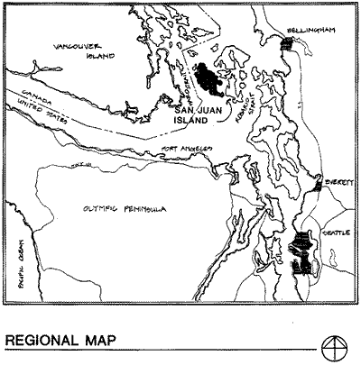
The San Juan archipelago lies north of the Strait of Juan de Fuca, between the southern tip of Vancouver Island, British Columbia, and the United States mainland. The park is located on San Juan Island, the second largest in the chain and home to Friday Harbor, the San Juan County seat. The island is accessible through the Washington State ferry system or commercial and private plane and boat.
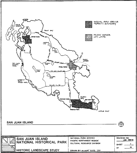
The park is comprised of three separate units: American Camp, 1,223 acres on the southern tip of the island; English Camp, [1] A 529 acres on the northwestern corner of the island; and the General Services Administration (GSA) leased administrative office and visitor contact space located on Spring Street in Friday Harbor. The park has a variety of resources, ranging from historic structures to public beach to archaeological collections.
|
| Vicinity map from the 1986 Historic Landscape Study by Cathy Gilbert, NPS Seattle Office. |
|
| San Juan Island map from the 1986 Historic Landscape Study by Cathy Gilbert, NPS Seattle Office. |
American Camp, with views across the Strait of Juan de Fuca and Griffin Bay, contains two restored historic structures from the period of military occupation: one Officers' Quarters and one Laundress' Quarters. The site is a mixture of driftwood-filled beach, rocky coves, windswept prairie, and forest. Standing near Eagle Cove, one can look west and see the tip of Vancouver Island, south to the Olympic range, and east to the mainland. The European rabbit abounds, providing prey for bald eagles and other raptors. Other wildlife includes deer and the occasional fox. Orcas (killer whales) can sometimes be seen from the shore. Archaeological resources include the sites of several other U.S. Army structures and camp features, the site of a mid-19th century Hudson's Bay Company farm, and prehistoric American Indian seasonal village sites.
At English Camp, located on the shore of Garrison Bay, four restored structures from the period of military encampment still remain: the Blockhouse, the Barracks, the Commissary, and the Hospital. In addition, stone foundation remnants of other camp housing can be located on the hillside overlooking the camp. An early twentieth century house overlooks the camp; the only reminder left of the Crook family homestead. Young Hill stands to the east of the camp, where a British Royal Marine cemetery is the final resting place for 7 marines and one civilian. To the north of the camp are Bell Point and Westcott Bay. The waterfronts along Westcott and Garrison bays are prime clam habitat, while the surrounding forests are home to a variety of wildlife, including deer. Guss Island located several hundred yards off shore in Garrison Bay, holds sacred importance to the Lummi Indians. Prehistoric ceremonial and seasonal village sites are located within the camp boundary and on the small island.
Purpose of Study
This history is intended to give the reader a general understanding of the park: the events it commemorates, the movement to recognize and preserve its historic sites, and the development, research, and planning that has occurred at the park since its inception. By providing a historical context for past management decisions, current and future park staff will have a better understanding of how the park was created and reached its current level of operation. This understanding will, in turn, assist park staff in making informed decisions as they guide the park into its next decade.
In 1995, the author completed an assessment of park files for the creation of the park's administrative archive. This included a search of regional repositories, regional NPS files, and the National Archives and Records Center. Unfortunately, the all-too-often-heard story of files being thrown out to save space applies to San Juan Island National Historical Park. Large gaps in the written record of park management have left some management decisions unexplained.
| <<< Previous | <<< Contents>>> | Next >>> |
sajh/adhi/chap1.htm
Last Updated: 19-Jan-2003