|
San Juan Island
Administrative History |

|
CHAPTER 2:
Historical Background
The history of San Juan Island contains the stuff of good popular history: absconding with livestock, drawing of guns, and angry words. Traditionally, the islands were home to an Indian people, the Central Coast Salish. During the era of exploration by European nations, Spanish, British, French, Russian, and later, Americans, entered the region, making it a part of an international fur trade. By the mid-19th century, the northwest became populated with a new breed: the settler. Nearing the close of the frontier, borderlands like the one shared by England and the United States were the site of power flexing and law breaking as those countries tried to bring these disputed territories under their control.
It is this borderland history that the park represents, the interaction of Salish peoples with Euro-American explorers, traders, and settlers, and the conquest and division of a continent between European and American governments.
Central Coast Salish
The San Juan archipelago is part of the traditional area of the Central Coast Salish, which collectively is made up of five component language groups: Squamish, Halkomelem, Nooksack, Northern Straits, and Clallam. [1] These five groups traditionally occupied the southern end of the Strait of Georgia, the lower Fraser Valley, and lands in and around the Strait of Juan de Fuca, including portions of the Olympic Peninsula and the entire San Juan archipelago. Within those five groups, there are several different associated groups. The Northern Straits, which by the mid-nineteenth century had six identifiable groups, occupied the islands: the Sooke, the Saanich, the Semiahmoo, the Songhees, the Lummi, and the Samish. [2] The Songhees, Saanich, Lummi, and Samish all had winter villages in the islands. Two other groups from the islands are believed to have joined the Lummi during the period of European settlement: the Klalakamish from the north end of San Juan Island and the Swallah from East Sound on Orcas Island. [3]
Northern Straits Salish were semi-sedentary, moving as seasons changed. Subsistence was based on a combination of fishing, hunting, and gathering. Fishing, primarily of salmon varieties, was of particular importance as seasonal runs provided numbers of fish, which were dried for winter stores. Hunting on sea included seals and porpoise, and on land, deer, elk, black bear, beaver, and in some cases mountain goats were taken. Gathering included a variety of mollusks, crabs, and sea urchins, as well as over 40 different seasonal plants, which provided food, medicines, and materials for crafts. Camas was of particular importance to the Straits Salish, who maintained camas beds utilizing reseeding and burning methods, and preserved their harvest for year round use. [4]
Salish groups had established winter villages, which consisted of one or more longhouses. These structures had a permanent framework of posts and beams with removable roof and wall planks. Summer homes were huts, with slabs of cedar bark. Northern Straits tradition during the early nineteenth century indicates that villages began developing defensive structures and designs into village construction, including trenching and wall building around the entire village. [5]
The basic social structure for the Salish was the household, which usually was composed of several related families. Kinship was bilateral rather than lineal, with both maternal and paternal relations holding similar status in terms of social organization and kinship. On a larger level, one household with several dependent households formed a local group or community. Individuals were identified by the group they resided with; the primary bond in local groups was a shared culture and language, not a unified political structure. [6] The concept of tribe would not come into being until relations with non-Indian settlers and the United States and Canadian governments necessitated such political entities. Conflict among villages was common, usually precipitating raids on the offending village.
The Salish relied heavily on canoes for transportation and subsistence activities. Carved from large cedar logs, the Salish constructed at least five different canoe styles. The Salish also engaged in various forms of art, mostly carving of house posts, grave monuments, tools, and ceremonial masks. The Salish also produced several types of basketry: burden baskets with an open lattice style for gathering shellfish and roots; tightly coiled berry baskets; and flexible cattail bags for dried fish. [7] Blankets were woven from wool of mountain goats or a breed of wool dog (now extinct) or from fireweed cotton. Salish also wove cedar mats for house construction, mattresses, and canoe mats.
Local groups were divided among worthy people, worthless people, and slaves. [8] The Salish participated in forehead flattening at early ages, with the exception of children born of slaves. Life ceremonies were celebrated around signs of puberty (menstruation or voice change) and marriages were negotiated. Feasts and potlatches were held around major life events or crises, usually held by all the houses of a village who invited villages from around the area. Special ceremonies were held for the first salmon, the spirit dance, cleansing ceremonies, and, in some villages, for secret societies. [9] At death, Salish were wrapped and placed in a raised canoe or box, with rituals held years later in which the body was re-wrapped and given a display of hereditary privileges, after which the deceased's name could again be spoken. [10]
The Lummi belief system places special importance on San Juan Island, particularly on a small island located in Garrison Bay called Guss Island. The Lummi believe this small island to be their place of origin into this world. This site holds sacred value that still remains with the tribe today.
Explorers, Traders, and Settlers
The Northwest coast area was "discovered" through sea-faring and overland expeditions by explorers and fur traders. Charles Barkley discovered the Strait of Juan de Fuca in 1787. In 1791-92, Spanish expeditions led by Manuel Quimper and Francisco de Eliza entered the region. George Vancouver's British expedition charted the region in 1792, and was followed by other Spanish explorers. After the turn of the century, traders began arriving from the east. In 1808, Simon Fraser of the Northwest Fur Company discovered the Fraser River Valley. In the extended trade patterns of the Northwest Indian groups, the Salish of the region already possessed European goods by the time of the explorer's arrival. Trade goods were not the only thing that arrived ahead of their purveyors: disease had already made its appearance. The first smallpox epidemic among the Central Coast Salish probably occurred as early as the 1770s. [11]
Between 1824 and 1845, the Hudson's Bay Company (HBC) began establishing settlements in the Northwest region, including Fort Langley on the Fraser River, Fort Vancouver on the Columbia River, and, in 1843, Fort Victoria at the southern tip of Vancouver Island. Until the late 1840s, the region's non-Indian population had remained small, born of the international fur trade. However, the discovery of gold in British Columbia changed the nature of the area for good. Gold seekers, mostly Americans, came in droves, and when they did not find their fortune they began to settle the region and look for a different means of making a living.
As the frontier began shrinking the issue of territorial ownership consumed the United States. In April 1846, the U.S. declared war on Mexico over Texas and the southwest borderlands. Diplomatic relations with England over the Pacific Northwest were considerably different than relations with Mexico. Peaceful negotiations for settling the division of the Oregon Country were already underway. England originally offered the Columbia River drainage basin as the boundary between the U.S. and Canada, which would have given them approximately half of present day Washington State. American settlers in the Pacific Northwest rallied for the U.S. to claim all of the Oregon Territory, to the 54° 40' parallel. But policy makers in Washington, D.C. were dealing with more pressing issues. Advocates for Texas annexation believed conflict with England over Oregon would weaken American defenses against Mexico. This applied also to those rallying for annexation of California. Northern merchants were interested in maintaining good trade relations with England, which they held more valuable than the disputed portion of Oregon Country. [12]
The deciding factor in the boundary settlement debate was President James Polk. Polk had previously offered the 49th parallel as the boundary line, but the British had refused. The Hudson's Bay Company's (HBC) northwest headquarters, Fort Vancouver, lay well below the 49th parallel on the Columbia River. Following the English refusal, Polk revoked the offer and renewed claim to the whole of Oregon, clear to the 54° 40' parallel. Congress, after pressure from Polk and much debate, passed a resolution demanding that the British vacate all of the Oregon Country in one year.
Polk's actions forced the British hand. England was also unwilling to go to war and offered a draft treaty in June 1846, setting the boundary at the 49th parallel. Maintaining good relations with the United States was of far more interest to the British government than a small portion of their remote North American landholdings. The HBC had also anticipated the loss of Fort Vancouver, establishing Fort Victoria in 1843 to replace Vancouver as their Northwest headquarters. Polk had said that the only way to beat "John Bull" was to look him straight in the eye and his calculations were right.
While agreeing to the 49th parallel, both sides agreed that all of Vancouver Island would remain British and that a water boundary would need to be established since the island dipped below the 49th. This process would throw the islands into a "no-man's land" of ownership. Only the HBC seemed to be particularly worried about the fate of the San Juan Islands in establishing a water boundary. HBC Governor J.H. Pelly wrote to Foreign Secretary of State Earl of Aberdeen regarding British possession of the islands, advising him to negotiate the Rosario Strait as the water boundary line. Despite this advice, negotiators used vague language with two plausible interpretations. The negotiators were interested in concluding and signing a treaty, allowing small details like the islands to be worked out later. [13] For that reason, the treaty determined the boundary between the United States and British Columbia as the 49th parallel, turning south at the middle of the channel separating Vancouver Island from the continent, then heading west down the middle of the Strait of Juan de Fuca to the Pacific Ocean. There are, however, two straits that could be interpreted as the dividing line: the Haro and the Rosario.
During the 1840s, development by British citizens on Vancouver Island extended to the San Juans. In July 1845, HBC officials from Victoria erected a wooden tablet near the southeast point of San Juan Island proclaiming British possession of the island. [14] HBC officials were well aware that the islands would end up disputed if Great Britain did not firmly proclaim their intentions with the islands, but during the 1840s the HBC concentrated their efforts establishing a presence on Vancouver Island. By 1850 or 1851, HBC officials established a seasonal fishing station on the southern end of San Juan Island. From 1845 onward, British authorities treated the islands as British territory.
In 1853, HBC officials began more permanent settlement on San Juan Island by sending Charles Griffin to develop a sheep farm. Livestock shipped to the island included 1,369 sheep, three horses, some cows, and one boar. [15] Construction started with a headquarters building and a house for his residence. Griffin was accompanied by at least two men to assist completion of construction plans. By spring of 1854, he had established a garden. In response to the threat of Americans, he erected a flagpole to fly the British flag. Griffin named the farm Bellevue.
Over the next several years, Griffin continued to develop Bellevue Farm. When the boundary commission appraised the HBC's operations in 1859, employees numbered eleven at Bellevue, with twelve to fourteen employees located elsewhere on the island. The farm had seven small houses, a barn, outhouse and shed, and about forty-six acres of land under cultivation. Griffin reported to having 4,000 sheep, 40 cattle, and a few horses. [16] In six years, the operation had grown substantially. American tax assessors, considering the islands part of their jurisdiction, estimated the size and value of the HBC operation much higher than Griffin's reports.
In the meantime, following the treaty of 1846, Americans considered the islands a part of the United States. Organized in 1848, the Territory of Oregon delineated counties incorporating the San Juan Islands into Island County. Five years later, when the new territory of Washington was created, the islands were incorporated into Whatcom County. In May 1854, Whatcom County officials began to assert authority over San Juan Island. The existence of Bellevue Farm spurred the county to try and establish a legal authority by placing a U.S. customs official on the island.
In April of that year, Griffin received word that the Americans were coming to seize the island. Upon reporting this to the Governor of British Columbia, James Douglas, Griffin was instructed to fly the British flag along the Strait of Juan de Fuca. On May Day, Douglas himself visited in a show of authority. With Douglas was British customs official James Sangster, who Douglas left stationed at Bellevue Farm in order to establish a legal authority.
On May 3, U.S. customs collector Isaac Ebey arrived on the island with Henry Webber and three men. [17] Ebey and Webber paid Griffin and Sangster a visit the following day and informed them that Webber would be the U.S. customs official for the island. Sangster replied that he would have to arrest Webber; Ebey merely remarked that he hoped the English treated him well. This began a series of moves and countermoves of political maneuvering, but no serious action.
On May 6, Ebey and Webber again visited Griffin. At this point, Ebey demanded an inventory of livestock from Griffin, who refused to give such information. The following day, Sangster tried to serve a summons for arrest on Webber. When the accompanying constable, a Mr. Holland, attempted to seize him, Webber drew a revolver and pointed it squarely at Holland's head. [18] The group was unarmed, and upon requesting arms to take Webber, Griffin refused. Thus the summons went unserved. The next day, Webber and Sangster both left for their respective headquarters to report the incident and request new instructions. Webber returned in two days with instructions to stay, but Sangster did not return. Griffin had requested Gov. Douglas send an official back only if he felt it was absolutely necessary. He was anxious to avoid a conflict, and so was Douglas. Douglas instructed Griffin to treat Webber as though he was a "private person, living under the protection of Her Majesty's Government." [19] Webber and Griffin developed a cordial relationship, and Webber depended on Griffin and the HBC farm for security from Indian raids.
Things remained relatively quiet until the following October when Whatcom County Sheriff Ellis Barnes visited the island, sent by Whatcom County Commissioners. He arrived at Bellevue Farm on the 19th and presented Griffin with a tax bill of $80.33. Griffin refused to pay. Three weeks later, Barnes returned and attempted to collect a second time. When Griffin again refused, he was informed that notices for a livestock sale at the farm had been posted and that Barnes intended to liquidate enough sheep to collect the $80.33.
Barnes returned on December 9th and informed Griffin that the sale had been postponed. On December 24, he again renewed his intent to sell at auction some of the farm's sheep, but again did not carry out his threat. Griffin and Douglas continued operations and in January, they began plans to expand the farm's pasture and crops. Douglas' confidence grew when Washington Territorial Governor Stevens visited him in Victoria to state his position that the island dispute was best left to their respective national governments for settlement.
However, on March 30, 1855, Barnes again arrived at Bellevue Farm and demanded payment. When Griffin refused again, Barnes set about finding and confiscating HBC sheep. The next morning, Griffin was summoned by one of his men and arrived in time to see Barnes and his men leaving with some of his livestock. Tallying up the damage, Griffin established that Barnes took 34 rams and 410 ewes and lambs, valued at 1,400 British pounds. After factoring in loss of production, labor costs to round up their remaining livestock, and added security measures, Griffin estimated the whole affair cost the HBC 2,990 pounds, roughly $15,000 U.S. dollars. [20] The U.S. Congress rejected Griffin's estimate as exaggerated.
At this point, U.S. Secretary of State William Marcy became aware of the political struggle going on in the region and gave Territorial Governor Stevens explicit instructions that local officials were not to commit any act that deliberately created conflict. Marcy believed that the dispute over the islands was a legitimate one that would require future arbitration between England and the United States. Stevens followed Marcy's orders, letting the issue go until arbitration was available.
The discovery of gold on British Columbia's Fraser River, like all gold strikes, brought a huge influx of people to the region. Many arrived seeking their fortunes, but few usually found it. Those who did not either left the region or began looking for another means of making a living. Many took homestead claims to try their hand at farming. That is how several Americans, including one Lyman Cutlar, came to settle and farm on San Juan Island.
Following the posturing of 1854-55, Great Britain and the U.S. established a joint boundary commission to survey the 49th parallel, from the Rocky Mountains to the Pacific for the purpose of clearing up any discrepancies in the treaty, including the placement of the water boundary. The U.S. assigned Archibald Campbell; the British assigned Lt. Col. John S. Hawkins, Royal Engineers, and Capt. James C. Prevost, Royal Navy. The commission players would later play a role in Pig War events and settlement.
From 1856 to 1859, no altercations developed on San Juan, although no one forgot for a minute that nothing had been settled. Douglas was consumed with matters on the mainland and Vancouver Island, dealing with the influx of miners and traders seeking to sell to the miners. Douglas attempted to enforce a license system for all miners and traders. Victoria had become a city overnight and was brimming with Americans. [21] At Douglas' request, detachments from the Royal Navy and Royal Engineers were sent to the area to provide additional law enforcement.
While the joint commission surveyed and completed its reports, the HBC continued its operations as normal. However, the American population around them was growing, much to Griffin's dismay. American surveyors made trips to the island to lay out claims for settlement. [22] Under Douglas' order, Griffin continued to treat them with respect and as settlers under the British flag. By June 1859, there were between 18 and 25 Americans living on San Juan Island. With an increase in American homestead claims on the island, Bellevue began to lose acreage to "squatters." The farm would continue to operate, but began losing its production value as settlement of the island's prime grazing land increased. In 1862, Robert Firth, Sr. succeeded Griffin as the manager of the farm, and shortly thereafter the farm was leased to Firth and ceased operations for the HBC. [23]
The previous years of tension and words between the English and Americans were a contributing factor to the Pig War, although it wasn't really a war at all. This is said very lightly and with hindsight, for the forces and firepower of the troops involved was considerable, and the situation could very well have ended with considerable damage and loss of life. Other contributing factors included Douglas' attitude towards American settlement and British policy. He felt that the British government had been weak in the face of American settlement and it had cost a significant portion of the Oregon Country. He regarded Americans settling in the area very unfavorably and as a continued threat to British possessions.
In return, the Americans mistrusted and disliked the HBC and British government, which they considered to be one and the same. Despite evidence to the contrary, popular belief held that the HBC instigated Indian raids on Americans in the Puget Sound. Americans following the gold rush into British Columbia were not appreciative of the restrictions placed on them by Douglas, including not allowing trade without a license from the HBC. While later revoked, the restrictions placed on Americans in competition with the HBC furthered the belief that the HBC operated as one with the British government.
Tensions that developed over legal authority and taxes, the attitudes of Douglas and American settlers in the region, and the fact that the boundary commission by 1859 had reached no agreement all laid the foundation for conflict. All that was needed was a reason for action and someone to make the first move.
On the morning of June 15, 1859, Lyman Cutlar, who had homesteaded near the Bellevue farm, found an HBC pig in his potato patch. Having previously seen the animal and warned Griffin to keep his animals off his property, Cutlar shot and killed the pig. Cutlar went directly to Griffin and informed him of his actions, and offered to pay the cost of the animal. Griffin then stated the cost of the pig to be $100, which Cutlar found to be unreasonable and refused to pay.
Later that same day, the chief factor of the HBC territory, A.G. Dallas, arrived aboard the steamship Beaver. Griffin informed him of the loss and a party consisting of Dallas, Griffin, and others sought Cutlar out. From this point forward, British and American stories diverge. Misinformation and exaggeration would aid in creating a conflict where none existed. Cutlar insisted that Dallas had demanded $100 for the pig and threatened to arrest him. Dallas claimed to have threatened nothing of the sort, that he had treated Cutlar with the patience the HBC had always shown squatters and had not demanded any money from him. [24]
Soon the story became more harrowing, as told by the U.S. customs collector, Paul Hubbs. According to his version, Dallas arrived on a British warship, and threatened to return with more warships as well as having Northern Indians raid the island and run the Americans off. According to Dallas, Cutlar saved himself only by threatening to open fire on them.
The British had no such intentions. The only effect the story had on Governor Douglas was to prompt him to assign a civil magistrate, John de Courcy, to the island to judge the incident and deal with American trespassing. Following June 15, nothing much happened. The feelings between the Americans and the HBC remained the same. On July 4th, the settlers raised the American flag in defiance of their British neighbors. This would prove a very fateful move.
General William Harney, commanding officer of the Department of Oregon, U.S. Army, was touring the area and stopped on the island when he saw the American flag. Harney would provide the main impetus for the military response to the situation. Speculation about Harney's actions during this time period range greatly, from political motivations to dumbwittedness. His conduct during the Mexican War showed a propensity for cavalier behavior that put him into insubordination situations and even a court-martial. Whatever Harney's reasons and motivations, his reaction to American settlers' version of events led to the landing of American troops.
Harney was livid at the settlers' story; of course, he was getting Paul Hubbs' exaggerated version. The settlers requested protection from any retaliation by the British and Northern Indians and Harney directed them to submit a written request to him for an army detachment for protection. Upon receiving the petition on July 11, Harney assigned Captain George Pickett and Company D, 9th infantry, currently stationed at Fort Bellingham, to go to the island and establish a military presence. Pickett's orders were to keep all Indians off the island and protect American settlers from them. He also briefed Pickett in the Cutlar affair and ordered him to resist all attempts by British officials to fine, arrest, or prosecute Cutlar in the matter. [25]
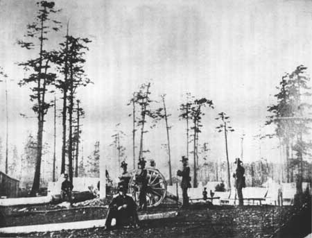
|
| 3rd Artillery, Camp Pickett, 1859 |
Of course, Harney sent these troops as a message to the British. On July 27, Pickett landed at the southern end of the island. Griffin visited the camp to try to ascertain Pickett's motives; it was clear to him that the American captain intended to stay and he sent word immediately to Douglas. Later the same day the HMS Satellite arrived carrying Magistrate de Courcy, who confronted Pickett and ordered him to leave the island. Pickett responded that he was following his commander's orders and would not leave. He also introduced Henry R. Crosbie, who had been assigned to the island as the American civil magistrate. The two magistrates realized the potential consequences of the situation and resolved to wait for word from their superiors. [26]
For Governor Douglas, there was one important question for which he did not know the answer. Had the governments of the U.S. and Britain solved the ownership issue and word from his government not yet reached him? American mail reached the Washington territory much faster than British mail was reaching Victoria, and it was possible that Pickett was on orders from Washington, D.C. The Satellite, armed with 21 guns, remained off shore of the American's camp. Douglas sent Captain Geoffrey Hornby, commanding the HMS Tribune, to relieve the Satellite. Douglas ordered Hornby not to interfere with Pickett and the troops already landed, but not to allow any other U.S. forces to land.
Despite orders from Harney and Douglas, the players actually on San Juan prevented an escalation to violence by properly assessing the situation. The British forces in Griffin Bay could have blown Pickett and his infantry to smithereens. Pickett's force consisted of 60 men, one 6-pound cannon, and three howitzers. The English combined force was 64 large caliber guns and 650 men. Pickett requested reinforcements and an additional company arrived on July 31.
Despite outnumbering the Americans, Captain Richards of the boundary commission and de Courcy advised Douglas not to force a confrontation; Douglas remanded his previous orders and did not confront the American reinforcements. The Legislative Council of British Columbia agreed not to attempt to force Pickett off the island. But Douglas could not accept American troops stationed on the island, viewing the offense as an insult to the British. Although he had agreed not to confront the Americans, he sent the HMS Plumper to the island with a detachment of Royal Marines. Douglas ordered Captain Hornby to land the marines and establish a joint occupation of the island to protect British subjects' claims and honor. [27]
The island became an area of great interest locally. Papers around the region proclaimed pro-American or pro-British sentiments and as many as 500 people visited the island.
Hornby met with Pickett to try and ascertain his orders, try and persuade him to leave, and to inform him of his intent to land and form a joint occupation. The two met on August 3. Pickett replied to Hornby's line of questioning by stating he was merely a subordinate following the orders of his general; he did not know on whose orders the general was acting, he could only assume that it was from Washington. Regarding a joint occupation, Pickett stated that he was in no position to make such a decision and would therefore resist any attempt by the Marines to land.
Hornby left the meeting without an agreement for joint occupation. Despite seriously outnumbering the Americans, Hornby had decided before meeting Pickett that he would not land his troops, feeling the situation did not warrant an armed conflict. Pickett, in the mean time, was trying to figure out what authority Harney had acted under and he admired Hornby's restraint in trying to ascertain clearly the situation, knowing that he could do very little if Hornby tried to land his troops. Pickett wrote to the general to inform him of the day's events and request further orders.
Harney, after dispatching Pickett, began a series of correspondence with the War Department to legitimize his decision. His letters were gravely exaggerated, trying to make the HBC the villain. Harney ordered Pickett not to allow any joint occupation of the island. In addition, Harney sent Lt. Col. Casey with his command, raising the number of American troops to 461. The Massachusetts arrived and three of the ship's guns were brought on the island and placed on an earthen fortification.
On August 5, Admiral Robert Baynes, commander of the British Pacific Fleet, arrived in Esquimalt on the 84-gun HMS Ganges. Baynes agreed with Hornby's decision not to force Pickett off. Douglas was in an increasingly untenable position, having no word from authorities in London to guide his action. The Legislative Assembly demanded at least some kind of action to assert British authority. But Baynes was not about to allow any kind of armed conflict and reduced the navy's presence. He ordered two of the ships in Griffin Bay to depart, leaving only the Tribune to watch the American activities.
Meanwhile, Douglas received a letter from Harney explaining the landing. Douglas learned not only why the landing occurred but also that Harney was acting on behalf of American settlers and not under the authority of the U.S. government. Douglas immediately wrote to Lord Lyons, British Ambassador in Washington, and informed him of Harney's actions and the island situation. Lyons had already heard of the incident through the papers and approached the Secretary of State. [28] No one in Washington, including President Buchanan, was pleased with Harney's actions. To remedy the situation, the president assured Lyons that the U.S. was not attempting to force a boundary settlement and sent General Winfield Scott to settle the matter.
Not only was it a blow to Harney to have his situation seen as a liability to be corrected, it was further insulting that Scott was sent to correct it. Scott and Harney had a history together, one that involved Harney's court-martial during the Mexican-American War. Previous letters to Harney from the war department informed him that he would be within the rights of the U.S. government to block attempts by the British to enforce jurisdiction over the island.
From late October into November, Scott and Governor Douglas negotiated a withdrawal of reinforcements and a joint military occupation of the island until their respective governments could settle the water boundary through arbitration. Although Douglas was reluctant to agree to a military occupation and had offered a joint civil occupation, he finally agreed to the military occupation. The agreement allowed each country to have no more than one hundred men encamped on the island. Captain L.C. Hunt was left in charge of Company A, 4th infantry and Pickett was ordered back to Bellingham.
Scott's agreement was not popular with residents of Washington Territory, who felt he had sold out American possession of the island, but officials in Washington, D.C. were pleased with the compromise. England believed that by allowing British troops to land, the United States was concurring that the sovereignty of the islands was still in question. They, too, were agreeable to the terms negotiated by Scott and Douglas.
One hundred of Her Majesty's Royal Marines, under the command of Captain George Bazelgette, landed on San Juan Island on March 21, 1860. They chose a site on the shore of Garrison Bay, on the northwestern corner of the island, to build a camp. General Harney, who had not been reprimanded or removed from his command as Scott thought he should, made another rash move. Angry over the landing of the Royal Marines, Harney ordered Pickett back to the island to replace Captain Hunt. He instructed Pickett to show Bazelgette his orders, which stated that because Scott left no orders with him to allow British troops to land, the agreement was not valid and he would allow them to stay only because Douglas agreed not to try and remove American troops. In addition, Harney's orders declared the islands a part of Washington Territory and the British would be subject to the laws of the territory, having no authority themselves, and that cases involving British citizens would be remanded to Admiral Baynes and Governor Douglas. Hunt immediately wrote to General Scott informing him of Harney's actions and declaration that the British had no authority on the island.
At the same time, Douglas and Admiral Baynes sent word to Lord Lyons in Washington regarding the actions, which violated the 1859 agreement. Harney had pushed the limits of tolerance for his actions. President Polk and Buchanan had previously managed to save face with the British without undermining Harney's position or removing him from his command. This later attempt to enforce American jurisdiction following the negotiated temporary settlement would not be so easy to explain. General Harney was relieved of his command and ordered back to Washington, and his orders to Pickett rescinded. Then the agreement negotiated between Scott and Douglas proceeded. General Scott concluded that the only reason war had not erupted over the island was the "forbearance of British authorities." [29]
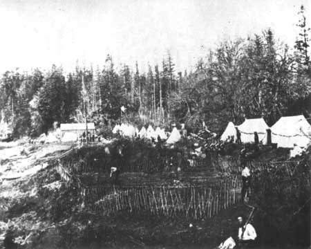
|
| English Camp, c. 1860 |
During the conflict, the island became a hot destination, first by tourists looking to witness any action, but then by more settlers and entrepreneurs. With two military encampments on the island, the population of San Juan Town (or San Juan Village as it is sometimes called), located on the edge of Griffin Bay next to American Camp, grew. With the lack of a formal civil authority and both military camps concerned more with each other, illegal activity in the form of liquor trade and prostitution abounded. Captain Hunt had very little success in controlling this activity, and both commanders wanted to limit the involvement of their troops in undesirable activities.
When planning the joint occupation, neither side probably anticipated that it would take 12 years to settle the water boundary question and that there would be a need for some kind of civil magistrate system. In order to deal with any lawlessness occurring on the island, the British and American commanders agreed to a joint military rule of the island, with British citizens coming under British laws and Americans under American law. Under this arrangement the commanders ruled the island in somewhat of a military state until 1872, each having jurisdiction over both their country's settlers. A great deal of cooperation and social interaction occurred between the two camps, including several social functions at English Camp that brought socialites over from nearby Vancouver Island. [30]
When the Royal Marines established camp, they erected tents and began construction of a storehouse for their supplies, a garden, and a small cookhouse. More formal construction at the site began later that summer, when requests for supplies and permission to build winter quarters were granted. That September, bids were let for construction of an early barracks building and a utility building for storage and bathing, which were completed near the end of October. [31] Work also began on officers' quarters and a formal cooking building, which was also completed that fall. In October, they established a lime kiln near Roche Harbor.
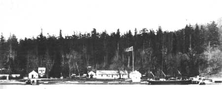
|
| English Camp, c. 1870 |
No further construction is recorded until 1867, when Bazelgette began complaining that the current living quarters had outlived their temporary nature. After a survey by the regional senior officer, it was agreed to let construction on a new quarters for the camp captain. Bazelgette would transfer before the new quarters were constructed. His replacement, Captain William Delacombe, arrived at Garrison Bay with his wife and three children. As the officers' family needs changed, so did construction needs at the camp. Following building of the quarters for Delacombe and his family, work began on quarters for one of the junior officers, who had married and whose family was also with him. Both contracts were let to area builders.
Between 1860 and 1867, many other structures were completed, including the blockhouse (guardhouse), the hospital, the commissary, a blacksmith shop, a stable, library/schoolroom, wharf and pier, flagpole, formal garden, sentry boxes, the cemetery, and wells. For a complete listing and identification of sites, refer to the historic base map for English Camp on page 85 and 110.
When Captain Pickett first landed American troops on the island in 1859, they set up a tent camp on the edge of Griffin Bay, near the Hudson's Bay Company wharf. Later, around July 30, Pickett moved the camp to the south side of the peninsula, next to a spring and away from the direct line of fire of the British naval guns in Griffin Bay.
Around August, the army began erecting some wooden structures at the camp, all constructed from materials taken from buildings dismantled at Fort Bellingham. [32] These structures included a barracks and hospital. With the arrival of Colonel Casey and more troops, the camp was moved again. Casey believed the site at the spring was too exposed to the wind and weather, and chose to move the camp to the north slope of the ridge above the HBC Company farm. Here there was a small stand of trees that would shelter the companies from the weather and provide a location on the ridge for the six guns brought off the Massachusetts.
On August 25, the army began construction of a fortification for the emplacement of eight 32-pound guns. The Redoubt, as it would later be called, provided coverage of water access to the southern tip of the island. [33] However, when General Scott arrived and the joint occupation was negotiated, Scott ordered a halt on construction of the Redoubt. The guns were placed back on the Massachusetts, and the army forces were reduced to one company. Five gun platforms constructed on the ridge now lay empty. The army men began calling it "Robert's gopher hole" after the army engineer who designed and supervised its construction, Lt. Henry M. Robert. [34]
No formal construction plans exist for Pickett's construction at the third and final site, but the written record indicates that officers' quarters, laundress' quarters, and a mess room and kitchen were constructed and a flagpole erected. [35] After Pickett's removal and the start of the American Civil War, construction plans were not a high priority. In 1865, buildings were freshly painted and a new arch constructed over the military cemetery.
In 1867, the same year that construction of more solid structures took place at English Camp, the U.S. Army began building better and more permanent structures. In 1859 when the joint occupation was negotiated and the detachments began construction of facilities, neither group realized that their stay would last so long. Both camps had built temporary structures and after six years were in need of improvements if troops were to remain.
To that end, the U.S. Army brought over more dismantled structures and materials from the now abandoned Fort Bellingham for use at American Camp. In all, two sets of officers' quarters, an adjuntant's office, noncommissioned officers' mess, a set of laundress' quarters, a new hospital, quartermaster storehouse, commissary storehouse, blacksmith shop, a two-story barn and stable, a granary, mess hall, and additions to other buildings were completed. [36]
Research indicates that the army built no less than 34 structures. Structures included the blockhouse/guardhouse, enlisted and officers' quarters, a bake house, barracks, messroom and kitchen, two hospitals, storehouses, a blacksmith shop, granary, carpenter shop, school and reading room, bath house, telegraph office, shoemaker shop, cemetery, roothouses, the flagstaff, and the Redoubt, among others. [37] For a complete listing and identification of sites, refer to the historic base map for American Camp on page 84 and 106.
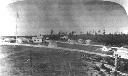
|
| American Camp, c. 1870. Photograph courtesy of the Provincial Archives, HP015273/A-05967. |
The water boundary issue was eventually placed in the hands of the Emperor of Germany for arbitration, along with other claims issues generated from the Civil War. Both countries were allowed to plead their case and on October 21, 1872, the emperor declared in favor of the Haro Strait and the United States. On November 23, the British marines evacuated the island. Not having specific orders regarding disposition of the buildings at the camp, the British commander turned all structures and lands over to the commander of American Camp. The army placed a small detachment of men on site for a guard and protection until 1874, when the American troops were recalled. English Camp lands were vacated when the army reduced its landholdings in 1875. [38] This would coincide with the arrival of a settler named William Crook, who moved his family into one of the officers' quarters and took up residence, receiving homestead certification from the U.S. government in 1883.
British citizens on the island requested assistance in settling land claims; most did not want to leave their homes. President Grant issued a proclamation forbidding land sales until all British claims had been settled. [39] In 1873, 72 Britons had requested American citizenship in order to keep their homes.
Of the decision, the retired James Douglas felt great disappointment: the islands he wanted to fight for so badly had indeed slipped through the British grasp and into American hands.
| <<< Previous | <<< Contents>>> | Next >>> |
sajh/adhi/chap2.htm
Last Updated: 19-Jan-2003