|
Payette National Forest |
|
RECREATIONAL VALUES AND USES
Lavishly endowed with the beauties of nature, the Payette Forest offers varied opportunities for pleasure and recreation. Here, far away from the stress and strain of modern living, one may relax beside quiet, cool streams, among green trees. Or from the mountaintop he may enjoy the scenic grandeur of vast expanses of wooded hills and majestic mountain ranges.
Beyond good motor roads, which run throughout the forest, are out-of-the-way places for those who yearn for undeveloped areas off the beaten track, where the beauty and splendor of the forest, its atmosphere of peace and quiet, its irresistible appeal, and glimpses of wildlife may be enjoyed without interruption. Three hundred and fifty miles of excellent mountain roads, built by the Forest Service, penetrate the forest and are open to public use.
Freedom of action on the part of visitors is interfered with as little as possible by restrictive rules. True, a forest guest will find it necessary to be careful with fire because of the dry condition of the forest fuel during the vacation season. He will be expected to leave a clean camp; refrain from damaging green trees and signs or other improvements; and observe the necessary rules of sanitation.
Located along practically all the forest roads are camping facilities which supplement the unusual scenic attractions of the Payette Forest. Except in periods of extreme fire danger, there are no restrictions on public camping anywhere on the forest.
A list of campgrounds, developed by the Forest Service for public use, and other accommodations follows.
|
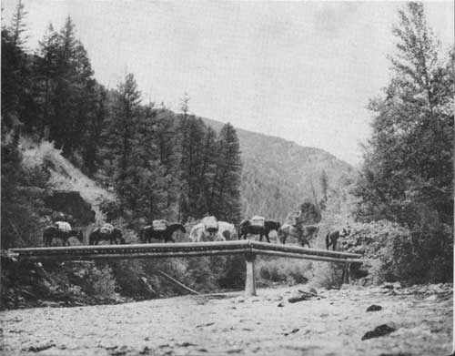
| PACK AND SADDLE HORSES ARE THE ONLY FEASIBLE MEANS OF TRAVEL OVER MUCH OF THE PAYETTE FOR THE FOREST RANGER, FOREST USERS, AND VISITORS. F—363522 |
CAMPGROUNDS:
WARM LAKE (Valley County).—27 miles east of Cascade. Improved forest road, piped water supply. Season—May to October; attractive lake, boats, tackle, fishing, and hunting.
TRAIL CREEK (Valley County).—18 miles north of Garden Valley on Middle Fork of Payette River road. Improved forest road, spring water supply. Season—May to October, fishing and hunting.
HARDSCRABBLE (Valley County).—13 miles north of Garden Valley on Middle Fork of Payette River. Good water supply. Season—May to October, hunting and pack trails.
BOILING SPRING (Valley County).—At Boiling Spring guard station, 36 miles north of Garden Valley. Improved forest road, piped water. Season—May to October; fishing, hunting, and pack trails.
BIG EDDY (Boise County).—On Idaho 15, 8 miles south of Smiths Ferry; nearest post office Cascade—26 miles. Pressure water system. Season—May to October, fishing and hunting.
HOT SPRING (Boise County).—18 miles east of Banks on Banks-Lowman forest road; nearest post office Garden Valley—6 miles. Improved forest road, spring water. Season—May to October, fishing and hunting.
PINE CREEK (Boise County).—East on Idaho 21 for 13 miles from Garden Valley to Junction, thence north 5 miles on Deadwood Reservoir forest road. Nearest post office Garden Valley. Spring water. Season—May to October, fishing and hunting.
PINE FLAT (Boise County).—6 miles west of Lowman on Idaho 21. Pressure water system. Season—May to October, fishing and hunting.
SWINGING BRIDGE (Boise County).—56 miles north of Boise on Idaho 15, 10 miles north of Banks on North Fork of Payette. Pressure water system. Season—April to December, fishing and hunting.
|
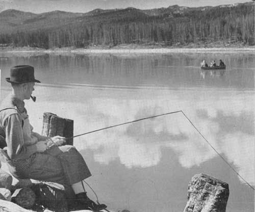
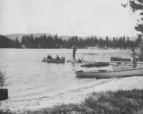
| FISHERMEN BY THE HUNDRED VISIT DEADWOOD RESERVOIR FOR BOAT AND OFF-SHORE FISHING. F—369520 |
OTHER ACCOMMODATIONS:
KNOX.—26 miles east of Cascade. Meals, lodging, gasoline, saddle horses.
WARM LAKE.—28 miles east of Cascade. Meals, lodging, cabins, gasoline, groceries, boats.
COX'S RANCH.—53 miles east of Cascade and 10 miles above Yellow Pine. Meals, lodging, gasoline, saddle horses, guide service.
JOHNSON'S RANCH.—45 miles east of Cascade on Pistol Creek Summit. Saddle and pack horses.
YELLOW PINE.—63 miles from Cascade. Meals, lodging, gasoline, groceries, general merchandise.
BEAR VALLEY DUDE RANCH.—80 miles from Cascade. Meals, cabins, saddle horses, gasoline.
|
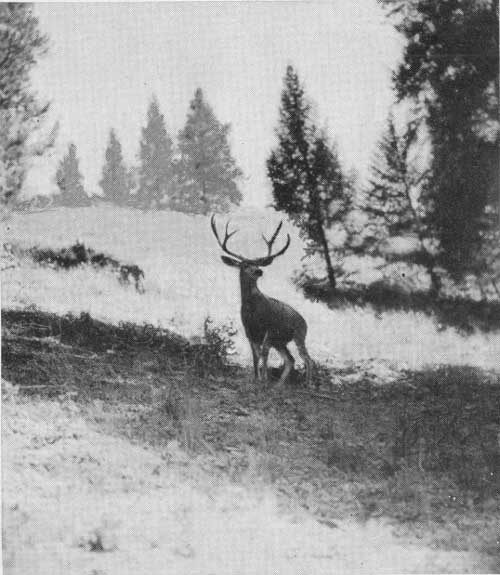
| POISED FOR FLIGHT. THIS HANDSOME BUCK IS ONE OF THE MANY THOUSANDS OF DEER THAT ROAM THE WILDERNESS OF THE PAYETTE FOREST. F—363508 |
Warm Lake Recreation Area.
From Cascade, the hub of the forest, the road leads east and north through dense stands of ponderosa and lodgepole pine and fir along Big Creek, up and over Big Creek Summit, and into Knox and the Warm Lake Recreation Area.
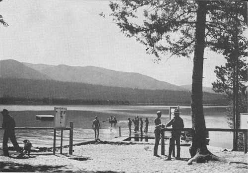
Warm Lake, which derives its name from the mineralized springs nearby, is the center of the largest recreation development on the Payette Forest and one of the most popular in southern Idaho. Here one may camp, picnic, swim, and boat in surroundings of great natural beauty. The playground contains many well-equipped camps, a public swimming pool, ball park, and boat landing. For those not wishing to camp, other good accommodations are available.
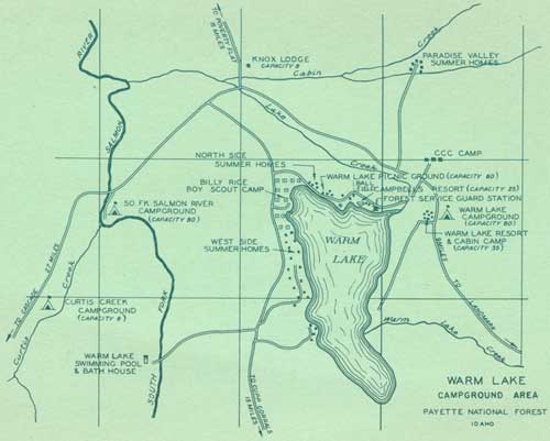
Seeking a cool haven from the intense heat of the summer months and indulging the American yearning for outdoor life, many residents of the Boise and Payette Valleys have leased from the Forest Service, at a nominal fee, sites along the lake on which they have erected summer homes.
Boy and Girl Scouts have also leased sites near the lake, where for a time each summer they make first-hand acquaintance with nature.
The outdoor swimming pool, fed from a mineralized hot spring, comes as a surprise when first seen in its sylvan setting of virgin pines and attractive rock outcroppings. Dressing rooms have been provided here for the convenience of swimmers.
Many other forest campgrounds have been and are being developed near this area, and its scenic features and excellent fishing insure its continued heavy use.
|
| PEACE AND SILENCE OVER WARM LAKE AS THE SHADOWS LENGTHEN. F—390005 |
|
| BILLY RICE BOY SCOUT CAMP AT WARM LAKE. HUNDREDS OF IDAHO AND OREGON BOYS VACATION HERE. F—389986 |
Visitors going to the North Fork area of the Payette travel an oiled highway through a beautiful canyon. The road runs beside a scenic river which rushes in cascading haste, with dense evergreen growth carpeting its banks to the water's edge. Once the scene of turbulent log drives manned by white-water rivermen from the eastern lumber regions, there now remains only a silent marker near the highway in memory of those who lost their lives in this perilous enterprise.
Cool, pleasant, attractive campgrounds, constructed and maintained by the Forest Service, lure passing travelers to pause and enjoy themselves among the colorful creations of nature. For the noncamper there are accommodations at several places along the canyon.
The scenic area along the South Fork of the Payette River affords an awe-inspiring trip. It is reached by turning right at Banks from Idaho 15 to Idaho 21 leading into Garden Valley. The road penetrates the enormous wilderness adjacent and lying south and west of the famed Idaho Primitive Area. At Crouch a road branches off up the Middle Fork of the Payette River and makes an interesting trip for those who wish to camp at the road's end and go by trail to streams at the upper reaches of the river.
Continuing east the road goes to Lowman through a rugged and picturesque canyon. Hot springs abound, and along the road a few miles past the Garden Valley Ranger Station, one of them provides a bathhouse with mineralized hot water. This is open to the public and is part of a campground which overlooks the river.
|
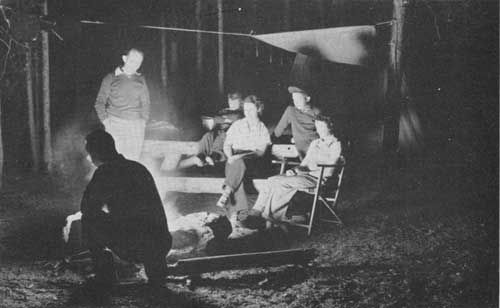
| ENJOYING THE CAMPFIRE AFTER THE DAY'S ACTIVITIES. F—389994 |
At Pine Creek, the Scott Mountain Motorway leads off to Deadwood Dam. Two excellent campgrounds located on this stretch of road tempt visitors to tarry and try their angler's luck. The dam, a concrete arch structure 160 feet high and 700 feet wide, impounds a maximum of 106,000 acre-feet of water. Boats are for hire here, and devotees of lake fishing usually make a good catch.
Two forest lookouts, Scott Mountain and Deadwood, are reached by roads which branch off from this motorway. Scott Mountain Lookout, at an altitude of 8,268 feet, affords an awesome panorama of jumbled mountainous terrain.
From Lowman, the road leads through a portion of the Boise Forest along Clear Creek and again enters the Payette Forest to continue through Bear Valley and on to the Stanley Lake region on the Sawtooth National Forest. Along this route new vistas open constantly before the fascinated gaze of the traveler.
For the lover of nature in its pristine form, untouched and unchanged by the works of man, there is the Idaho Primitive Area, which includes a million and a quarter acres of the Payette, Idaho, Challis, and Salmon National Forests. The Payette is the principal gateway to this vast undeveloped area, which may be entered from Landmark or Bear Valley, jumping-off points from developed roads and modern methods of transportation.
The wilderness unit has no automobile roads, and the only practicable means of access is by trail with saddle horse and pack outfit. It is designated by the Forest Service to remain as nearly as possible in its natural condition, unmarred by modern structures or conveniences, save those necessary for administration and protection. It is recommended that competent guides be employed for wilderness trips.
|
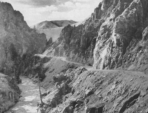
| ROADS LEADING INTO THE BACK COUNTRY TAKE ONE THROUGH SCENIC AND ROCK-BOUND GORGES LIKE THE SOUTH FORK OF THE PAYETTE RIVER. F—369497 |
Throughout this vast, wild, undisturbed empire flows the Middle Fork of the Salmon River, a mighty stream in itself and the mecca of fishermen from all parts of the Nation. The Middle Fork was originally called "The River of No Return," because its rapid, turbulent waters which dash over a boulder-strewn bed make it impossible to navigate a craft upstream. This name is now applied to the main stream of the Salmon River.
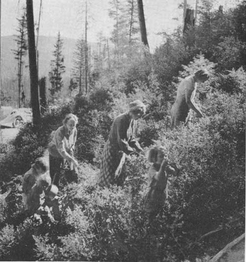
HUCKLEBERRYING IS GREAT SPORT
A minor but delightful resource of the Payette Forest is its abundant yield of wild mountain huckleberries. During the last of July and early August, thousands of gallons of this delicious fruit are picked, to be made into delectable pies and jams. Huckleberry time is the signal for many people to pack their troubles and duffle and hike to the hills on berry-picking expeditions.
Some of the best berry patches are in the following areas:
Along the foot of West Mountain, from a point southwest from Cascade and north of Brush Creek the entire length of Long Valley to a point opposite the village of Donnelly. Some years when the late frosts do not kill them, good berries are found along the north side of Beaver Creek, about 5 miles northwest of Cascade.
An area which lies south and east of the old town of Cabarton, and known as Grassy Flat on Fawn Creek, is the camping site for scores of berry pickers during August nearly every year.
|
| WHEN IT'S HUCKLEBERRY TIME ON THE PAYETTE FOREST, HUNDREDS OF FAMILIES FROM THE VALLEYS MIGRATE TO THE HIGHLANDS IN SEARCH OF RECREATION AND THIS LUSCIOUS FRUIT. F—398399 |
|
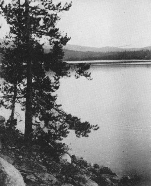
| WARM LAKE—A SPOT OF RARE BEAUTY—OFFERS ALL KINDS OP OUTDOOR RECREATION TO A GROWING NUMBER OF VISITORS. F—389999 |
The famous mountain berry also grows on the east side of South Fork of the Salmon from Knox ranch north to the forest boundary; on Lone Mountain, due west of Warm Lake and east of South Fork of the Salmon; also between the mouth of Trout Creek and Rustican Creek on the east side of the Landmark-Yellow Pine road.
It is possible to stop at good improved campgrounds along the Middle Fork of the Payette and Silver Creek and scout the environs for easily accessible berry patches.
| <<< Previous | <<< Contents>>> | Next >>> |
|
handbooks/payette/sec3.htm Last Updated: 19-Nov-2010 |