|
Payette National Forest |
|
Fire Number One Forest Enemy
FIRE IS THE FOREST'S arch enemy. It can destroy the growth of a century in a few minutes. Lightning fires, which cannot be prevented, account for 6o percent of the fires on the Payette Forest each year; the other 40 percent are the result of human carelessness in discarding lighted cigarettes, cigars, and pipe heels, and by leaving campfires unextinguished. Causing a fire through carelessness is a crime against all citizens.
The war on fire demands quick detection and rapid attack. The construction of lookout stations, telephone lines, roads, and trails; the development of fire-fighting equipment; the transportation, feeding, and care of fire fighters; and the tactics of fire fighting require the ranger's most determined study, preparation, and performance. No quarter is given in this fight.
Fire hazard is always high on the Payette Forest between June 1 and October 15. All visitors are requested to carry a shovel, ax, and water bag, at least during the most critical periods in July and August.
The forest maintains about 450 miles of grounded or single-wire telephone lines for fire communications and administrative purposes. Telephones are located at all ranger and guard stations and lookout houses; also, at a number of private cabins and other places scattered over the forest. They are available to the public for reporting fires and other urgent use.
LOOKOUTS ACCESSIBLE
Four lookouts on the Payette National Forest can be reached by automobile. Scott Mountain and Deadwood Lookouts are on the Scott Mountain Motorway, a road branching off from the South Fork of the Payette road at Big Pine Creek. Silver Creek Lookout may be reached by driving north from the Garden Valley store for 30 miles up the Middle Fork of the Payette River and Silver Creek. Gold Fork Lookout is reached by a road which takes off from the Cascade-Knox road at Johnson Creek, 15 miles from Cascade.
In addition to the Payette Forest lookouts, the South Idaho Timber Protective Association has two well-developed lookout stations, accessible by road. East Mountain Lookout may be reached by turning east about 7 miles south of Cascade on the main highway; and Packer John by turning off the main highway at Smiths Ferry, crossing the river, and turning south at the loading corrals.
|
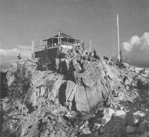
| SCOTT MOUNTAIN LOOKOUT—ATOP A GRANITE CRAG—A HOUSE OF MANY WINDOWS SHELTERS THE LOOKOUT MAN WHO IN CONSTANT VIGILANCE SCANS THE VAST TIMBERLANDS BELOW. F—369506 |
LANDING FIELDS PROVIDED
Several landing fields have been developed for use of airplanes, principally for delivery of men and supplies in case of fire and for service to isolated ranches and mining camps.
Fields have been located on the Middle Fork of the Salmon River at the mouths of Mahoney and Indian Creeks and opposite the Hood Ranch; in Pen Basin, about 2 miles from Landmark; at Yellow Pine; the Yellow Pine Mines Syndicate on Meadow Creek; at Bryant Ranch on Johnson Creek, 4 miles above Yellow Pine; and at Oberbillig's mine near the Bryant Ranch. These flying fields are usually small and not recommended for general use, since special equipment and experience are required. Flying service is available at Cascade.
| <<< Previous | <<< Contents>>> | Next >>> |
|
handbooks/payette/sec4.htm Last Updated: 19-Nov-2010 |