|
The Early Days: A Sourcebook of Southwestern Region History — Book 1 |
|
SHORT HISTORIES
In 1926, at the dedication of the Coronado Trail road, Mr. John D. Guthrie presented the following paper:
Over Historic Ground
By John D. Guthrie, U.S. Forest Service
One day in the last part of May 17 years ago, there started out from Clifton, Arizona, a party of three men. They were headed for Springerville, about 126 miles to the north. They rode over the famous old trial up Chase Creek to Metcalf. The purpose of their trip was to find, if possible, a feasible route for a road over the Blue Range and the White Mountains — from Clifton to Springerville. Only one of the three had ever seen the country through which they were to go. The three were District Engineer Jones of the Forest Service office in Albuquerque, Forest Ranger David Rudd of the Apache National Forest, and the writer, who had just been appointed Forest Supervisor of the Apache National Forest the previous November.
Jones knew nothing of the country, having come into Clifton by train; my knowledge was limited to what I had been able to see from the bottom of the Canyon of the Blue, which wasn't much to worry about. Only David Rudd was familiar with the region through which we were to go. He had accidentally shot himself through the side about a year previously, and not having recovered, it was decided not to take a pack outfit on this trip, but to stop at what ranches or cow camps there might be encountered; we encountered none!
From all possible sources of information about the country and from what maps were then available (and these were few and poor), the most likely route seemed to be to follow the old Mitchell Road out of Metcalf and then keep on the divide between Blue River and Eagle Creek, to the top of the Blue Range, that was to be a problem.
That seeded the route later, but when we started we didn't know just where we'd land, nor where we'd stop for the nights. Dave could not tell for he did not know whether we'd go up Eagle Creek, up the Blue, or up the divide.
Anyway, we started out, 3 men, 3 horses, 3 saddles, and 1 canteen and 3 small lunches. The first night out from Metcalf I well recall. It was somewhere on the south side of Grey's Peak. There was a spring with watercress in it; there were pine trees and pine needles, and only Arizona's blue sky overhead for a cover.
No bedding, no chuck, except the dried remains of a lunch we had had put up at Metcalf. We sure slept out. Somehow we put in the night. I wonder if the new road goes by the spot? The Spanish Captains of Coronado's caravan may have camped in that spot on their way from Mexico to Zuni in May 1540. Who knows?
The Captains may have known as little about the country as we did but they did have 600 pack animals and provisions. Our caravan of 1909, 369 years later, certainly was traveling lighter. Their record speaks of big pines, watercress and fish in the streams, and wild game. That first camp of ours was Spartan in its simplicity. We just stopped, threw off our saddles, hobbled the horses, built a fire (merely for social purposes), and somehow the night wore away.
The next morning Dave Rudd did something I never saw done before. He had an old-style army canteen, the kind with the laced canvas cover. Dave had some ground coffee along, but there was no pot, no cups, no cooking outfit. There wasn't even an old tin can left by some former camper.
Coronado must have left a clean camp and a dead fire. May all his followers over this trail do likewise. Dave's ranger ingenuity came to the front. He ripped off the cover of the canteen, filled it with water, set it upright between two rocks, and built a small fire around it. When boiling well, he lifted it from the fire, poured in a lot of coffee — and, after seeping and cooling, we took turns at the breakfast coffee urn. The coffee was strong — mucho huerte, as the local saying is, but it was our life-saver. That was our breakfast and coffee never tasted more wonderful. Perhaps Coronado's men quenched their thirst in a heavy Spanish wine, but it could not have tasted better than our canteen coffee that May morning in 1909.
I don't think the Engineer cared for the camp nor the coffee particularly, especially since he was wearing on this trip a stiff white collar.
We were simply looking over the country to see if a road were feasible, on not too heavy a grade, and at not too prohibitive a cost, from the copper towns of the south to the cool, green forests to the north with the fish, watercress, pine trees, and wildlife of Coronado's day.
We followed as best we could the divide between the Blue and Eagle drainages, through Pine Flat, circling Grey's Peak and Rose Peak, and struck the rim of the Blue Range, climbing it over a trail that went nowhere but up.
That was the third day out from Clifton. Dave supplied the knowledge of the country that could not be seen; the Engineer (in a collar now not quite so white) took many "sights" with his level and made notes, and we climbed to Hannagan Meadow and rested there the third night. The snowdrifts were plentiful and deep.
The Engineer still wore his stiff collar, now past all semblance of its former self. There was neither fence nor cabin at Hannagan Meadow (not Hannagan's Meadow). Two deer came out in the Meadow early next morning to feed. A grouse whirred away from the spruce tree under which we slept. There was white frost on the aspen poles around the spring when I went down for a drink. Across our trail down to Black River that morning stalked a flock of wild turkey.
That day we rode into Springerville from Hannagan Meadow, a right nice little ride, via the Slaughter Ranch, Big Lake, Pat Knoll, and Water Canyon, with big appetites and tired horses, and one dark-brown, still a collar, on the neck of the Engineer.
The conclusion at that time — and that was in 1909 — was that such a road could be built, with a fairly good grade, but that it would be expensive. Somewhere in the Government files are Engineer Jones's report and maps covering that reconnaissance for a road from Clifton in Greenlee County to Springerville in Apache County. The next year (1910), another Government Engineer (Howard B. Waha) made another reconnaissance, but his route ran up Eagle Creek, through the Indian Reservation, and around the west end of the Blue Range.
This is now 1926. It has taken 17 years to build that road. Governments move slowly and cautiously. That looking over the country for a road in May 1909, was the very beginning of the Clifton-Springerville Road. Coronado went over it, but he was looking for gold and treasure, not roads.
His historian, Casteneda, did set down what are destined to become treasures of the region, perhaps as valuable as the mythical gold Coronado sought — the tall pines, the fish, the watercress, the wild flowers, and the wild game.
Now people will again come up over this route from the South, as Coronado and his Captains came, seeking something. I wonder if the Spaniard put out his camp fires, if he left camps clean. With 600 pack animals and 1000 men he must have had many camp fires gleaming in the pines along the route from the "Red House" to Zuni. Being a soldier, I suspect he had order in his camps. I suspect he left his campfires safe; he must have left some fish, some game, some watercress, and the oak, pine and spruce trees, for they are still to be found along his old trail.
* * * * * * * * * *
A memorandum to the files that deserves to be quoted:
| 00 | ||
| Apache-Fire | Memo | January 23, 1912 |
Mr. Becker told me on January 20 that prior to 1881 few if any stock of any kind ranged on the White Mountains, and that up to that time fires ran over the Mountains each spring, that from about May 15 until the summer rains the Mountains were smoking from fires set by Indians on the Reservation, that from that time (1881) on, stock were driven on the Mountains and the fires began to be stopped, and the young timber began to start, that most of the young growth has started since 1880. Fires used to burn down into the foothills and he was caught in Water Canyon once with a team of oxen, in a fire trap, and just escaped unhurt. He said that people here used to go up on the Mountains to camp and the grass on the cienogas was very thick and matted, (having escaped the fires by being moist) and they used to roll down their beds on this heavy mat of grass.
John D. Guthrie, Forest Supervisor
* * * * * * * * * *
The following brief history of the Datil National Forest, New Mexico, July 1910 to May 1913, while undated and unsigned, is believed to be accurate.
History of Datil National Forest, New Mexico,
July 1910 to May 1913.
Headquarters: Magdalena, New Mexico. Area: July 1910 - 2,957,801 acres. Staff, July 1910: Forest Supervisor, William H. Goddard; Forest Ranger at Large, A. H. Douglas: Forest Assistant, R. L. Deering: Chief Clerk, H. L. Stevens; Assistant Clerks, Mrs. Verna H. Seeley and Miss Isabel H. Mordy. Rangers in Charge: Water Canyon R. S., L. G. Haynes; Rosedale R. S., R. F. Rhinehart; Monica R. S., J. J. Bruton; Red Rock R. S., Walter M. Barnes; Jewett R. S., John F. Russell: Luna R. S., Amasa Reynolds; Tularosa R. S., M. D. Loveless; Negrito R. S., W. M. Griswell; Hood R. S., R. S. Blatchford: Baldwin R. S., D. F. Wells; Chloride R. S., B. F. Hooton. Forest Guards: S. Q. Garst, Cy Shank, R. M. Atkins.
In 1910, the Datil National Forest was in a decidedly undeveloped state as far as transportation facilities were concerned. Its three million acres bordered for the most part the edges of the immense San Augustine Plains. It consisted of several widely separated units that ran all of the way from the Water Canyon country east of Magdalena to the very western edge of the State where it joined the Apache National Forest in Arizona. It had the Gila Forest as its neighbor on the South. Slow, main routes of transportation, absolutely devoid of directional signs, existed in the shape of rough, dirt wagon roads, with stretches of heavy sand in places on the Plains, that linked the main centers of population.
The Forest owned a team of roan horses named "Blueberry" and "Strawberry." They were so wild when they were first acquired that it was said to have taken from three to four men to hitch them up in the stable before the doors were opened. When this happened, the horses made a wild dash for the open air, with the light buggy to which they were hitched sailing along over the ground. Blueberry, though large, was an excellent and gentle saddle horse, but Strawberry was a powerful bucker when the mood struck him to act up, as it often did. Later on the team developed a bad habit of balking in the morning when they were supposed to be ready to start a trip which made the initial stages rather low in mileage. The team was disposed about 1912. None of the Forest Officers had automobiles but most of the rangers had large strings of good saddle horses that they rode hard with frequent changes in mounts.
Representative trips that were taken on horseback or less frequently with the official team and buggy were Magdalena to Rosedale, 35 miles, 8 hours; Magdalena to Durfee Wells, 21 miles, 5 hours; Durfee Wells across the Plains to C-N Ranch, 35 miles, all day; Magdalena to Tularosa Ranger Station, 85 miles, 2-1/2 days; Magdalena to Hood Ranger Station, Reserve, 115 miles, 3-1/2 days.
Frontier conditions obtained throughout the Forest in 1910, and the residents of one of the principal creeks were said by one of the Washington Inspectors to be as hard a lot as existed on any Forest in the Nation.
While conditions in Magdalena at this time were not quite as lively as they were in the old days when the cowboys were said to have run their horses up and down the board sidewalks of the main street and jumped them off the high end near the Santa Fe branch railway station, occasionally shooting into the air, or perhaps putting bullets through the walls of the few houses that bordered the street; still in the fall when some 100,000 head of cattle and sheep were handled through the corrals, things were decidedly brisk and the saloons and brothels did a heavy business.
The main stores that were in operation in Magdalena at the time were Becker-McTavish and the Ranch Supply Company, which were the sources of supply for the Forest and communities. The major timber sales were those to the above two mercantile outfits, to W. H. Hughes and to Montague Stevens. The largest cattlemen using the gramma grass ranges of the Forest were V+T, J. W. Medley, Grossmans, C. C. Cooper, Chas. McCarty, J. W. Mayberry, Bill Jones, J. S. Ward, and Ray Morley. The larger sheep outfits were Frank Hubbell, Solomon Luna and his sister Mrs. Bergere, and Holm O. Bursum.
W. H. (Bert) Goddard, Forest Supervisor, was a fine type of man for the Forest Chief at this stage of its development. He was a thoroughly practical cowman who not only could lay down the law to the users but could do it in such a way that they took it with reasonable liking. He was very fair-minded. He gave the younger men who broke in under him lots of help but also believed in giving them room to show what they could do. He was quite a practical joker and was generally well liked, not only by the permittees but also by his Forest force.
Douglas, Barnes, Russell, Reynolds, Criswell and Wells were thoroughly dependable men of broad experience. Haynes was a graduate of Kansas State and really built the first extensive telephone lines on the Forest. He was assigned to a District in the winter.
In the summer of 1910, Assistant District Forester, T. S. Woolsey Jr., of the Branch of Silviculture of the District Forester's Office in Albuquerque, made a general inspection of the Forest. From a sample check he made of the pasture permits, he decided that these must be so inaccurate that all of the uses of this kind must be checked by compass and chain with corrected permits to be issued where areas under fence were found to be 20 acres or over in error. The job of making the check was assigned to Forest Assistant Deering, who practically finished the job by the end of the year with the assistance of the Rangers in charge of the different Districts. Most of the pastures were found to be materially larger than the permits called for, and corrected permits were issued for all cases needing such action.
In 1910 and 1911 the Montague Stevens sawmill west of Reserve was operating about as effectively as it ever did. Mr. Stevens was an extremely well educated Englishman who was said to have lost his right arm some years before in an argument with a bear. His wife was supposed to have been a member of a fine English family. Stevens was very fond of animals and had several cats and dogs seated around his dining table in chairs. These were alternated with his human guests. His wife was a charming woman of catholic tastes. The family was supposed to have lost a lot of money in the old days in fraudulent stock deals. A sign over the door read, "The more I see of men, the better I like dogs," and when this was taken into account along with reports of pigs and chickens in the kitchen, an invitation to a meal at the Stevens was something to be avoided if at all possible.
On September 19, 1910, the Forest had a Ranger Meeting in Ranger Rhinehart's District near the Becker-MacTavish sawmill in the San Mateo Mountains. This meeting took up timber estimating, marking, check-scaling, brush piling, June 11 homestead examinations, pasture and other surveying. The meeting continued through September 24. Associate Forester Earle H. Clapp and Paul P. Pitchlynn from the District Office were in attendance.
In the latter part of October 1910, Assistant Ranger M. D. Loveless, Tularosa R. S. caught some 34 Indians with pack animals loaded down with illegally secured venison jerkey. After a trial, the Indians left the country sadder but wiser, pretty well stripped of anything they could dispose of to help meet their fines.
On December 1, 1910, a group of District Office men visited the Forest under the direction of Harrison D. Burrall and established some permanent sample plots in the cut-over areas in the north end of the San Mateo Mountains.
On February 4, 1911, a very sad incident occurred when Assistant Rangers J. D. Jones and Clinton Hodges, after accepting deputization by the Sheriff, shot and killed John Latham on the J. W. Medley range a few miles west of Magdalena. Latham was caught by the Rangers, assisted by Mr. Medley, owner of one of the large cattle outfits, in the very act of burning offal remaining from the carcass of an animal belonging to Mr. Medley which Latham had butchered illegally the previous day. The Rangers, armed with 30-30s, were within a very few feet of the man who tried to seize his "long Tom" as Mr. Medley sought to disarm him. He was so nearly successful in getting his gun out of the holster that it fell free as he dropped to the ground, shot through the body. Both shots fired hit him and he died instantly. The Rangers were completely exonerated after a hearing in the Spring of 1911.
In March 1911, Supervisor Goddard assigned Deering, with the help of Engineer H. B. Webs from Albuquerque, to examine the West end of the Forest, recommend eliminations where needed, and post the boundary on its final line. This work continued until June 10 when it was closed down and covered all of the country from the New Mexico West Line clear around through the Lueras Division. The Lueras Division at least had never been posted before and many new corners were found along its line. The work was done with team, saddle horses, and afoot. Assisting in the work were ex-Ranger Walter Musick, Ross Atkins, Guard Miller and Juan Carrejo, later Ranger. From time to time District Rangers also helped on work done on their districts.
On September 23, 1911, Secretary of War Stimson and General Leonard Wood visited Magdalene. They were on a tour of the Army Posts and went over the Plains West from Magdalena.
In 1910, 1911, and 1912 there was a great deal of activity on Forest Homestead applications. The Rangers, often assisted by Deering and alone, examined and reported on many such claims. They were called June 11 applications because of the date of the authorizing Law, June 11, 1906.
On June 14, 1911, Assistant District Forester J. K. Campbell, from the District Office of Grazing, visited the Forest and made a grazing inspection trip on the Western part. He and Supervisor Goddard drove the Government team and visited Tularosa Ranger Station where Ranger Bunton, formerly in charge of the maintenance work in the Albuquerque Office, was then located. Bunton knew Campbell very well from his previous office association and warned him the Supervisor was quite a practical joker, so if he tried to get Campbell to ride a certain one of the Government team, he should insist that he wanted to ride the other one. This was explained as a ruse to get Mr. Campbell on the horse that bucked. When Mr. Goddard tried to get Mr. Campbell to ride "Blue", the gentle horse, he insisted on riding the other one. Mr. Goddard reluctantly consented after a warning that the horse was rather a rough actor. Thinking all was well, Mr. Campbell sank his spurs into his horse at the start, with the result the horse downed his head and did his best to throw his rider. Because of the latter's skill as a horseman, he was not unseated, but later learned that the real joker was Bunton and not the Supervisor.
On May 2, 1912, the first reference is found in the diaries of the time to the use of the automobile on official work when Deering, Ranger Bunton, Frank and James Hubbell, sheepmen, rode in a car to some allotment boundary posting work.
On May 7, 1915 (?) The Forest lost one of its most valiant supporters when Solomon Luna, one of the largest sheep permittees, was accidentally drowned in the night in a sheep dipping vat at Horse Springs.
In the spring of 1912, because of a general belief that the stockmen in the Tularosa country were running more stock than they were paying on, Supervisor Goddard decided that a roundup and count of several outfits was desirable. Authority for such action and funds to carry it out were secured. The Stockmen were notified to get ready to assist in the count. Chas. McCarty, one of the men whose permit was considered to be most out of line, objected strenuously to such action. However, after securing some wise legal advice, he came into the office in Magdalena on June 13, 1912 and said in a doleful tone, "I will agree to the count." He signed a written statement to this effect and soon after the work began.
It ran through most of the summer under the general supervision of Ranger W. S. Day. Three experienced cow hands were hired and the work was carried on by these men assisted by the Rangers, who were assigned to it from time to time. The riders and the permittees whose cattle were being counted also helped. The stock of Bill Jones, Chas. McCarty, J. K. P. May, C. C. Cooper and several others were counted. Excesses were found, the largest, as was suspected, in the McCarty outfit. The cattle were rounded up and after being counted were daubed with a splash of paint on their hind quarters. This was to prevent their being tallied more than once. Black paint was found to be the best color for the Datil herds. The job of applying the paint on a hot day in a dusty corral proved to be rather a trying one.
On September 26, 1912, Stanton G. Smith came out of the District Office to look over some of the Forest, with the object of checking the need for boundary changes. He, Supervisor Goddard and Deering drove in a new car belonging to Dr. McCreery of Magdalena to the North Star country. The expedition ended in disaster as the Doctor carelessly tore out the transmission of his car and Deering had to make a ride under forced draft clear to town in the night from the rather isolated V+T headquarters for new parts for the car.
On October 13, 1912, through October 18, 1912, a joint Ranger Meeting was held with the officers of the Gila and Apache Forests west of Reserve. Chief of Operation A. O. Waha represented the District Office. A serious break in the transmission of the EMF car that was taking Mr. Waha back to Magdalena with a few of the members of the Supervisor's staff a day or two before the meeting ended occasioned a 7-hour stop in the middle of the road while the driver repaired the car and a bitter cold drive over the Plains in the middle of the night. Neither the cars of the time nor the condition of the roads themselves were conducive to travel with speed and safety in automobiles.
* * * * * * * * *
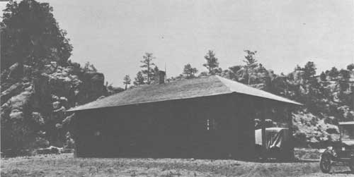
|
| Figure 33. New Beaverhead Ranger Station Datil National Forest June 1923. Photo by John D. Jones |
In 1926. Fred Croxen was a Forest Ranger on the Tonto National Forest. He prepared a paper entitled. "History of Grazing on the Tonto", and presented it at the Tonto Grazing Conference held in Phoenix on November 4 - 5, 1926. This paper was reissued to the Tonto personnel in 1944 by F. Lee Kirby, then Forest Supervisor. Mr. Kirby's memorandum of transmittal and Mr. Croxen's paper of 1926 are quoted in full:
|
History of Grazing on Tonto
The history of grazing on the Tonto Forest from the time of early settlement to the present is the subject that has been assigned to me. This covers so much that a book could be written on it and makes me wish that I had the ability to do so.
The few old-timers from whom I have secured my data are among the first settlers on the Tonto, and while their dates may not always be correct and they may not agree in some regards among themselves, I feel that all are reliable men and the information secured from them as to conditions in the past is reliable. They are men who have seen this range at its best, have seen the stock industry rise to the peak and descend to its present condition. Stories told by these old men while I have been with them, sound like fairy tales, for everything differed so much in those days from what we see of the ragged end of it all at the present time.
Arizona had been traversed in the northern and southern parts for several decades before white men ventured to any extent into the part now covered by the Tonto Forest, for the early California gold rush was on and the greater part of the people had eyes only for that. There was little trading to be done with the Indians of these parts, as they were treacherous and warlike, and travelers were only too glad to stay to the main routes of travel and let this, then, little known, country alone.
Shortly after the Civil War, the government began to renew interest in this remote and arid country and established a few army posts throughout the Territory, most of which were poorly manned. The troops made scouting trips throughout the country in the late '60s and '70s. A few prospectors, traders, packers and other venturous characters accompanied the troops, found indications of the precious metals in the mountains and took out stories of the fine grasses and ideal climate to others of their kind who were interested. The cattlemen, always anxious to spread out and find newer and better ranges for their cattle soon brought small herds to these mountains, growing these herds into larger ones, while larger herds were driven in at later dates.
Florance C. Packard, probably the oldest living man to settle in Tonto Basin, came from California to the Salt River Valley in 1874, where he was told of the Greenback Valley by an Army officer. He came to Greenback, liked it and settled there in 1875. He came as a professional lion hunter, for the territory paid a bounty of $20 at that time, and was a keen observer. He tells of Blackfoot and Crowfoot Gramma grass that touched one's stirrups when riding through it, where no Gramma grass grows at present. The Pine Bunch grass grows all over the Sierra Anchas in the pine type and lower down than the pine timber on the north slopes. There were perennial grasses on the mesas along Tonto Creek where only brush grows at the present time. Mr. Packard says that Tonto Creek was timbered with the local creek bottom type of timber from bluff to bluff, the water seeped rather than flowed down through a series of sloughs, and fish over a foot in length could be caught with little trouble. Today, this same creek bottom is little more than a gravel bar from bluff to bluff. Most of the old trees are gone, some have been cut for fuel, many others cut down for the cattle during drouths and the winters when the feed was scarce on the range, and many have washed away during the floods that have rushed down this stream nearly every year since the range started to deplete. The same condition applies to practically every stream of any size on the Tonto. The first real flood to come down Tonto Creek was in 1891 after it had rained steadily for 12 days and nights. At this time the country was fully stocked, the ground had been trampled hard, much of the grass was short, or gone, gullies had started and the water came rushing down. This flood took a good deal of the agricultural land from the ranches along the creek and was so high that it filled the gorge where it entered Salt River at the present site of the Roosevelt Dam and backed a house up Salt River about a mile.
E. M. (Chub) Watkins, whose father, Captain W. C. Watkins, settled on Tonto Creek in 1882 at which is now known as the H4 Ranch, tells about the same story of early conditions as Mr. Packard. He says Curley Mesquite grass covered the foothills but did not extend to so low an elevation as at present, these lower elevations having been covered by grams and other grasses now gone. His people came from Indian Territory and brought the finest horses that ever came to this part of the State, if not the entire State, owned a bunch of greyhounds as well, and used to run jackrabbits all over the mesas along Tonto Creek from the box to the mouth. There were no washes at all in those days, where at present arroyos many feet deep are found and at places cannot be crossed.
Cliff C. Griffin, the present owner of the 76 Quarter Circle Ranch on Tonto at the mouth of the Wild Rye Creek, came to Salt River and settled in 1884 on some of the part now covered by the Roosevelt Reservoir. He says the principal grass was Black Grama and a species of Sage. The Black Grams used to cover the slopes on each side of the river. In those days this came up in bunches, approximately 5 inches at the base, grew to a height of two to two and a half feet, when a sheaf-like spread of two to two and a half. This was very nutritious, making the finest kind of feed for cattle. He says in early days the settlers used to chop this grass for hay, using heavy hoes for chopping and with a hoe, rake and fork he could fill a wagon in two hours' time with this grass.
Mr. Griffing told of a George Allen who had a ranch and bunch of cattle opposite the mouth of Tonto Creek, who milked Devon cows and sold butter in Globe for $.75 per pound. He put up Alfilaris hay for those cows, by pushing a kind of rake or sweep across the mesas and collecting it in windrows, it grew so rank. This was in 1886 and alfilaris was not in Arizona until after the advent of the sheep from California. Florance Packard says he first saw a little of it in Sunflower Valley about 1880. While mentioning the Allen Ranch, Mr. Griffing said that Mr. Allen told him he was going to get $5,000 for it some day, as he had a reservoir site, meaning the present site of the Roosevelt Dam. This was in 1886 and Mr. McCormick, former State Historian, claims to have been one of the party who discovered it in 1889.
William Craig, at present a resident of Payson, later settling on Weber Creek, on the Pine District with his partner Paul Vogel, a Frenchman, came to old Marysville, a small mining camp three miles west of the present site of Payson February 10, 1881. He says Black and Crowfoot covered the ridges and foothills at that time and Curley Mesquite was mostly along the draws. This speaks well for the Mesquite grass and bears out the statement of lots of stockmen that, "if it wasn't for the Curley Mesquite, there wouldn't be any grass."
Mr. Craig says Big Green Valley, which is now the Chas. E. Chilson Ranch; Long Valley, where the present town of Payson is located; and Little Green Valley, 14 miles northeast of Payson, were waist-high in grass and certainly pretty to look at. He says the Pine Bunch grass in the pine timber under the Rim was three feet high and stood in great bunches. The cattle and horses that grazed on it ate only the heads. Sheepmen first set fire to the Pine Bunch grass under the Rim when passing through, so they would have young tender feed for their sheep the next trip. Those sheepmen were from New Mexico and Daggs Brothers and others from the Little Colorado slope. The influx of Texans, Colonel Jess W. Ellison, on Ellison Creek, Walter Moore on Moore Creek a little west of Ellison Creek; Sam Haught, Sr., who settled on the head of the East Verde with his sons, Sam Jr. and Fred, and others killed lots of Pine grass by following their former methods of the plains by burning the old mature grass. The roots of the Pine grass are very close to the top of the ground, so it was soon killed out in this way. There is little of this grass to be found under the Rim at present.
Revilo Fuller, a resident of the Pine settlement, first came to Tonto Basin in 1877. He says, "on Hardscrabble Mesa there was a red-topped grass that had a good head and grew to a height of about 16 inches. This was not a bunch grass but grew on stems, similar to Blue Stem." There is none of this grass to be found now.
All the men interviewed state that there was little brush in the country at the time stock was first brought in, and it was possible to drive a wagon nearly anywhere one desired. The little that there was, was only on some of the mountains and some of the slopes. Chub Watkins stated that nearly all the north slope of Mt. Ord was a Pine Bunch grass country. At present (1926) this is one of the brushiest pieces of range on the Tonto, as anyone will agree who has been unfortunate enough to have come in contact with it.
Such was the condition of the country, the streams and the grasses at the advent of white men with their herds of cattle, horses and sheep. It is little wonder they flocked to this stockman's Paradise with its fine grasses, well-watered ranges, and ideal climate.
One thing that was of assistance to new settlers coming into the Tonto Basin country was the roads that were built by the Army under the regime of General Stoneman. It was he who first built the road from Camp McDowell on the Verde River to Fort Reno in Tonto Basin, and from Fort Reno up through the Basin and connected with the military road he built from Camp Verde to Fort Apache. Both of these roads were used by the incoming early settlers. Stoneman Lake on the Coconino Forest is named after General Stoneman.
As I have already mentioned, the stockmen soon came in after the Apaches were somewhat overcome by the soldiers, they having heard such glowing accounts of the Tonto Basin from these soldiers, scouts, prospectors, and packers. To show just how rapidly it was settled, I shall name some of the outfits, the dates they came in, and the herds they had or acquired, and how they increased or decreased as Fortune favored them in their efforts.
The early influx was from California and Oregon, while some came from the Mormon settlements in Utah; later settlers came from Texas and New Mexico.
According to Florance Packard, the first cattle to be brought to Tonto Creek were by John Meadows, in 1876. There were 50 head of these, mixed Red Durham cows, and they were brought from California.
Christopher Cline and his five sons drove a herd in the same year and settled on lower Tonto. There were 400 head in this herd, so far as I can learn. These were also driven from California, coming from the vicinity of San Diego. Christopher Cline was the grandfather of all the Cline boys now grazing permittees on the Tonto.
A.A. Ward stocked the Sunflower Ranch on the west side of the Mazatzals about 1880, but I do not know how many cattle he had.
Along the Verde River were the Ashurs, the Sears, and the Menards, all bringing cattle in from California in the early '80s. Charley Mullen, now a resident of Tempe, once told me that he and his brother had cattle at the Club Ranch high up on the west side of the Mazatzals in 1882. He said this was the finest grass country he had ever seen, and it must have been for it is still one of the best ranges on the Tonto although it has been heavily stocked for as long as any on the Tonto.
The first cattle to be driven to the Payson country was in 1877, by William Burch and William McDonald, two old bachelors, who drove their cattle, about 50 head, from the Walapai Mts, in Mojave County to Tonto Basin, coming through the Verde Valley, then up over the Camp Verde - Ft. Apache Military Road to what is now known locally as Calf Pen Draw and down Nash Point to Strawberry Valley, and on to where they settled in Big Green Valley. They had a mule team and light wagon, a saddle horse and pack mule. This outfit allowed them to travel where their fancy suited. These men later married two of the Hazelton sisters, relatives of the Hazelton family now living in the Buckeye country on the Gila. Wm. Burch was the father of Haze Burch, the Phoenix policeman killed by two outlaws while trying to arrest them in February 1925. They also had the first sawmill in Payson and hired Vi Fuller of Pine to haul it from Maricopa for them in 1879 or '80. Many of the old stumps are still standing on the area logged by this mill. When Wm. Craig came to Payson in 1881, the herd of Burch and McDonald had increased to about 100 head.
Houston Brothers were located at Star Valley, 6 miles northeast of the present town of Payson, at the time he came in. They had about 300 head of cattle and had driven them from Tulare County, California. They branded the U Bar, which is still in existence and is run by the Clear Creek Cattle Co. above the Rim.
O. C. Felton, father of George A. Felton who resides on Tonto Creek, and his son-in-law, Brody, a half-breed Cherokee, came from Oregon and California in the late '70s, spent one winter on Lower Oak Creek in the Verde Valley and then came to Tonto Basin, bringing cattle and horses with them and settled on Tonto at the mouth of Rye Creek.
Marion Derrick settled at what is now the Indian Garden Ranger Station in 1882. His brother-in-law, Levi Berger, settled Little Green Valley in 1883. Derrick has 180 head of improved Mexican cows and Durham and Devon bulls. The bulls were purchased on the Verde River and one of them was an improved Devon bull from England.
Derrick hired Paul Vogel, now living in Payson, to build the log fences still to be seen at Indian Garden. In 1883, he and other settlers built the old log house, still standing, as a protection against the Indians. Derrick is said to have been a good man for the country, but unfortunately went broke through his expenditures for improvements. etc.
Wm. Craig built the adobe at Little Green Valley in 1884, which is the main room in the present house.
John H. Hise, from Chicago, formerly a merchant of Globe, purchased Little Green Valley from Berger and later sold it to the Allen Brothers.
Wm. Craig and Paul Vogel, the first a mule skinner and wagon-master for government contractors in the Southwest and the latter a Civil War veteran and bull whacker for contractors across the Great Plains, settled the Spade Ranch on Weber Creek on the Pine District in 1883. The mines on Weber Creek were discovered the same spring and were considerable of an aid to them. They set out an orchard in the spring of 1884, getting the trees from Hirtsville, Alabama. This grew to be one of the very best orchards in the country and at one time had 1200 bearing trees, all well cared for.
They started in the cattle business with one cow and calf, later buying five more. Their increase the first few years was 80 to 90% and one year was 100%. It never was below 70% all the time they were in the cattle business. Mr. Craig always kept his cattle broke to salt and to come at the call. They first secured salt from the mine at Camp Verde of very poor quality, but after a few years were able to purchase salt from the Mormons who freighted it from Salt Lake, New Mexico.
Mr. Craig says the salting of salt was a great handicap and many did not do it, losing many cattle as a result. He says while at the Zuni mine on Wild Rye Creek, in the early days, he has ridden the length of it and not been out of the odor of dead cattle and they were dying in grass knee-high — for the want of salt.
Wm. O. St. John, one of the original locators of the Oxbow mine, came to Tonto Basin in 1878. He located on what is known as the St. John's Place, four miles south of Payson and maintained his headquarters camp there for himself and others, mostly Army men. Al Seiber, Crook's Chief of Indian Scouts, who was accidentally killed on the Roosevelt Road in 1907, and Sam Hill, an Army packer, still residing south of Payson, were two of St. John's compadres and hung out at his ranch.
Mr. St. John started with a few milk cows and grew a small herd, later disposing of them and acquiring Pyeatt's herd of goats about 1885, building them up to about 5000 head. He disposed of these to Max Bonne, at one time owner of the H Bar outfit, who wanted the brush range for winter range for his cattle.
Colonel Jess W. Ellison, an old-time Texas cowman and trail driver, shipped a herd of something like 200 head of cattle and a large remuda of fine horses from Texas to Bowie, Arizona, unloaded at that point and trailed to Tonto basin, settling with his family on what is now known as Ellison Creek, directly under the Big Rim, in 1886. Owing to these cattle not being used to this climate and not knowing where to drift to a warmer range, about one-third were lost the first winter, snows being heavy and the grass covered up. Like most of the early settlers, Mr. Ellison planted fruit trees, setting out an orchard of 3000 trees at this place. A great many of these trees are still standing and bearing fruit.
Walter Moore brought in 700 head of cattle in 1886 and settled on what is now called Moore Creek, about two and a half or three miles west of Ellison Creek. From all accounts, these cattle met with about the same hardships as the Ellison herd and due to other negligence in handling them, did not pay, so his brother who had staked him had the remnant gathered and taken out.
Sam Haught, Sr. and his sons, Sam, Jr. and Fred, the former son now living on Walnut Creek on the Pleasant Valley District and the latter on his mining claims on Spring Creek, trailed 700 head of cattle from Texas and settled on the upper East Verde in 1886 or '87. At least a part of these cattle were driven to the mountain in the summer and held in the vicinity of General Springs Canyon. The ruins of the Old Fred Haught cabin is still to be seen about a mile below the General Springs Fireman Camp.
According to Mr. Craig, a Mr. Stinson was the first man to put cattle in the Pleasant Valley country. These were brought from the Mormons in the late '70s in the colonies around Snowflake and St. Johns.
The Tewksburys' came into Pleasant Valley from northern California in the early '80s. He was a Scotchman and his wife a California Indian. They brought their stock with them.
The Grahams came from Iowa, brought stock, but I do not know from where or how many.
These two families were the leaders in the famous Graham-Tewksbury War, sometimes called the Pleasant Valley War.
Tom Hazelwood trailed 5000 head of cattle from Texas and settled in Pleasant Valley in 1885 or '86. He was warned by the warring factions not to come in, so wintered in Luna Valley, New Mexico, and came on in the next spring.
W. T. McFadden, father of Pecos McFadden, trailed the MO brand of cattle from Texas in the early '80s, settling on Spring Creek at the place now resided on by Jim-Sam Haught. I did not learn how many cattle were in this herd, but there were several hundred head.
Mr. Haigler, owner of the Bar X Ranch northwest of Young Post Office, used to buy steers from the Salt River outfits as yearlings, grow them out at his ranch and drove them to the railroad at Holbrook for shipment.
According to Mr. Craig, a good many bulls were purchased from the Murphy Bros, of Tulare County, California, from herds they trailed through to their holding in Old Mexico. They hired only Mexican punchers and it was easy to arrange to have good cattle dropped out of the herd by them. The last herd driven through were all sold out on the San Pedro River, so many having been taken out that they knew all would be lost before they could be gotten through.
Cliff C. Griffin, the present owner of the 76 Quarter Circle Ranch on Tonto Creek, with headquarters at the mouth of the Wild Rye Creek, came to Salt River March 1st, 1884. He purchased Devon cattle that year from Jim Hazard on Salt River and has either owned cattle or been interested in them in a financial way ever since. I have already given an account of the range conditions as seen by him at that time.
There were several farming and stock ranches on the river at that time. Simon Kenton, a descendant of the old Kenton family of Indian Scouts on the west side of the Allegheny Mts. was one of the first settlers, coming in 1876 from Oregon with Roan Durham cattle and settled on Salt River just above the mouth of Pinto Creek. He had two bulls that weighed a ton each. At one time he butchered two 3-year-old steers that dressed 1300 pounds each.
Henry Armer, the father of the Armer boys, brought Red Durham cattle from Oregon and settled on Salt River about 1876. At one time he bought a yearling steer from Simon Kenton that dressed 500 pounds.
Jim Hazard ran an outfit for Welbridge and Fisk on shares, with headquarters on Salt River opposite the mouth of Pinto Creek. This outfit had about 400 head of Devon cattle, which was a big outfit for that part of the country in those days.
Mr. Griffin says that cattle did not drift up as far as Walnut Springs when he came to Arizona in 1884, but grazed in the valley and along the lower foothills.
While conversing with Mr. Griffin in regard to early range conditions, he mentioned that he has butchered 18-month-old steers that dressed 472 pounds, and he once sold a 2-year-old steer that dressed 630 pounds. Pete Bacon butchered a 2-year steer in the vicinity of Reynolds Creek Ranger Station that dressed 700 pounds. Steaks were cut from the outside of the ribs of this steer. These cattle were all raised and fattened on grass only, which proves that there was real grass in those days. Compare the cattle of today that graze on the same ranges. Cows calved every month in the year and raised calves every year, and cows bred and raised calves until they were 20 years old and older. Mr. Griffing said that after the stockmen got to trailing their cattle to Holbrook they were herded during the roundups instead of being held in pastures, which caused them to become footsore. A good percent had to be turned out as they could not be driven up the hill out of Salt River on the Holbrook drive.
Mr. Griffin said that in 1884, he and J. H. Baker, who was a resident of Salt River, went up on Aztec Mt. This country was not known to settlers of that date but they found a log cabin and a white man's grave at what is now the Peterson Ranch. Baker raised 22 tons of potatoes at this place that year and packed them across the Pinal Mts. to Silver King, building his own trail to get them across, and sold them for one-half cent per pound.
He also mentioned that Glen Reynolds, at one time Sheriff of Gila County, who was killed by the Apache Kid while taking him and other Indians to the State Prison, first located the present site of the Reynolds Creek Ranger Station, and built the old log house now on the place.
At first, the mining camp of Globe and a few small surrounding camps was the market these cattlemen had to depend on, but there was nothing regular about it. The average price was $25.00 for yearling steers.
The early settlers on Salt River raised what was known as Egyptian Corn, which was similar to Milo Maize but had a larger head that hung down from its own weight. They had to discontinue raising this product on account of the damage done to it by the birds.
My information as to the Mormon Settlements of Pine on Pine Creek, Mazatzal City on the East Verde, and Gisela on Tonto Creek, was secured from Vi Fuller, one of the original locators on the East Verde. His story is that in 1877 a party of six men with pack animals started out from the Mormon Settlement of St. George, Utah, consisting of his oldest brother, Wid Fuller, Woodward Freeman, Thomas Clark, John Willis, Alfred Randall, and himself. They crossed the Colorado River at Pierce's Ferry, below the Grand Canyon. After looking around they decided to locate on the East Verde River, in the Tonto Basin.
The party gave a man by the name of Jim Samuels $75.00 for his claim and divided it among the six of them. They returned to Utah next year and started with their families and stock to their new home. Vi Fuller and Alfred Randall, the father of the Randall boys at Pine, each had some cattle and then took what they called a cooperative herd from Wid Fuller for three years on shares. Their stock was too footsore to make the trip across the Mogollons, so they spent the winter of 1878 - 79 at Black Falls on the Little Colorado River and came to the new settlement next spring. They arrived with about 80 head of regular Utah cattle and had three Durham bulls, all sired by an $800, Durham bull.
The first year the cattle did not do very well. Due to the trip and the poor condition of the cows, they got only a crop of 10 or 12 calves. The next year they got salt from the salt mine at Camp Verde, and the cattle did better. Those cattle gradually increased and they brought a Durham bull in occasionally to breed up the herd.
After the Indian scare of 1883, at which time the band of Indians broke out from San Carlos and were later about all killed on Battle Ground Ridge on the Coconino Forest, Mr. Fuller and the other settlers on the East Verde moved up to Pine, where they could secure better protection in case of any more outbreaks.
Mr. Fuller says their principal market was Phoenix and Camp McDowell. One drive was made to San Carlos Agency in the early '80s. Only aged steers and some old cows were sold. One drive to Phoenix was sold for $45.00 per head as they came, and the butcher buying then estimated the bunch would dress 500 pounds per animal.
Another of the early markets for cattle was the then thriving mining camp of Silver King, near what is now called the Superior. At that time Superior was called Queen Creek. Frank Mayer was the butcher at Silver King and came up to the settlements, bought the cattle himself and stayed with them until they were delivered. Mr. Fuller says he certainly took to anyone that he saw crowd or hit one of those beef cattle. Mayer later bought the NB Ranch on the East Verde at the mouth of Pine Creek, and it was run for him by George Cole, who married the oldest sister of Wash Gibson, a resident of Payson at the present time.
The old Mormon Settlement of Gisela was settled in 1881. Davy Gowan, who is credited with discovering the Natural Bridge, had a claim at Giesela and Mart and John Sanders bought this claim from him, giving him a span of mules, harness and wagon and a buckskin horse in trade. Vi Fuller later sold these mules for $500.00 in gold. This settlement thrived for a number of years, but was later given up by the Mormons and none live there at present.
Mr. Fuller says that a man by the name of Ike Lothian, a Missourian, was settled in Strawberry Valley when his party came through there in 1877. He had no cattle, but had two mules and a saddle horse. He farmed about 20 acres of land at the lower end of the valley, raised corn, fed it to the hogs he raised, butchered them, cured the meat and packed it to the Army post at Camp Verde and elsewhere. Mr. Lothian was the first settler in Strawberry Valley.
Mr. Fuller says droughts came at different periods but there was sufficient grass and browse to carry them over until the range became overstocked and overgrazed.
He says there were beaver in the streams in Tonto Basin in the early days but they were not trapped by white men. The floods caused by the denuding of the ranges finally washed them out. There was an occasional wolf in the late '70s and the early '80s, and quite a few lions, but the lions did not bother the stock as deer were very plentiful, deer being the natural animal for them to prey on, He says one could ride from Pine to the East Verde settlement and see deer on every point.
It is interesting to hear Mr. Fuller recite his early experiences, he being one of the very few real old-timers left in the country. He came to Utah with the first Mormon settlers in 1846, was a freighter along the line of the old Pony Express through Nevada and Utah in the early '60s, was with his father in Los Angeles in '61, at which time he saw his father pay $2.50 for a fat 2-year-old steer, $.60 per hundred for barley, and $.40 per sack of corn. When they returned in '62, everything had gone up and they paid $80.00 per ton for the poorest kind of hay and everything else was in proportion. He made one trip from Salt Lake City to Platte City, Nebraska, the farthest western point of the Union Pacific at that time, with a mule team for freight and returned with a load of reapers, at the rate of $16.00 per hundred. This trip in the early '60s took about three months.
Horses: The Tonto Basin was never much of a horse country. The stockmen and settlers usually raised their own horses but not in large numbers. The country taken as a whole is too rough and not the type adapted to the successful raising of horses. Lions have always been a handicap to the industry, getting many of the colts as well as aged animals.
Mr. Art Sanders, who lives in Globe, told me that he and his brother John bought 1089 head on Wild Rye Creek and the vicinity of Payson in 1905, paying $3.00 to $5.00 per head for them. These were an accumulation of the range horses owned by everybody. They were sold to Senator Hayfield and Nail, and shipped to South Carolina and Alabama.
There were a good many horses in the Pleasant Valley country in the early days. The big cow outfits used to drive their remudas lower down in the winter and hold them on the grassy ridges and foothills along Tonto.
Sheep: The first sheep were brought into Tonto Basin by Fred Powers, in 1876, and were held on Tonto Creek. These were brought from California to Mojave County in 1875, and on to Tonto in 1876. Davy Gowan was the herder of this band. Powers ran sheep until the varmints got so bad he had to go out of the business.
Old settlers say there were not coyotes in this part of the country until stock were brought in, and that there were no skunks in Tonto Basin until after the old Fort Reno was established, after which they followed the soldiers across the Mazatzals from Camp McDowell and the Verde country.
The sheepmen from the higher country and from New Mexico got to driving their herds into the Tonto country and on the west slope of the Mazatzals to winter on the grass and to lamb in the spring. This country had already been fully stocked by the cattlemen and it only worked a hardship on them to have these sheep wintered on their range. Considerable hard feeling was the result, the cattlemen oftentimes drove the sheep out of the country and one man, Gene Packard, a brother of Florance Packard. A range war was about to open when the Tonto Forest was created, which put a stop to the sheep wintering on the Forest. I was told by Cliff Griffin that he once heard Al DeSpain remark that had he known the Forest Service was coming in and control the sheep and goats, he would not have sold his holdings on Wild Rye Creek in the finest of gamma grass country, but would willingly have paid $2.00 per head for the protection alone.
One fall George Scott, one of the present users of the Heber-Reno Driveway, came on Hardscrabble Mesa west of Pine with four bands of sheep and heavily armed herders and tenders. Seventeen cattlemen took them unaware and disarmed the outfit, threw the bands together, shoved them off into Fossil Creek and told them not to come back. Scott camped away from the bands to save his own hide and could not be found by the cattlemen.
Another incident happened to George Wilbur, another present user of the Heber-Reno Driveway, when he drove into the Sombrero County and started to lamb. The cattlemen, on whose ranges he was, dropped so many bullets around the outfit that they were glad to leave and promised never to come back, which they didn't.
Charley Edwards, a cattleman on Tonto Creek, stood them off for a number of years to save his range with most of the time little support from his neighbors. He finally had to shoot a camp to pieces and the next morning this band was clear on the west side of the Mazatzals and came back no more.
The above incidents are mentioned to show the condition of affairs at the time the Forest Service took over the area within the Tonto Basin. All this occurred on ranges that were already overstocked with cattle.
Goats - The first goats were brought in by Andrew Pyeatt, father of Benton and Walter, who are residents of Payson, in 1882, and was only a small band used for meat. These were later sold to William O. St. Johns as has already been mentioned.
John Holder is the first man who brought goats to Tonto Basin in any quantity, bringing about 3000 head in from New Mexico about 1896. He brought several thousand more in later. He ranged his goats principally on the East Verde, but also had some of them at Gisela for a time.
J. H. Fuller at one time had goats and ran them in the vicinity of the Diamond Gap Rim and had a camp at the present ranch owned by Arthur L. Neal, on Lion Creek. He also ran those goats on top of the Rim at what is locally known as "The Goat Corral", on the head of Cracker Box Canyon west of General Springs.
The Neals and Booths had goats at Gisela and Ira Hickcox had a bunch on Wild Rye Creek at his ranch just above the present Boss Chilson ranch.
The Crabtrees and Hughes Ward had goats in the Ram Valley and Sunflower country for a number of years, and John Gilliland had goats at Sugar Loaf Butte on Sycamore Creek, four miles northeast of the present Rio Verde Ranger Station. Some of these outfits went out of business of their own accord, but the Forest Service required all who had goats on the range at the time the Forest was created to remove them.
Hogs - The first hogs in the Tonto Basin country that I could learn of, and I believe they were the first, were a bunch that Jim Samuels, a Scotchman, and Sam Hill, an Englishman, both from Prescott, turned loose along the foot of the Mazatzals in 1876. These hogs did little good on account of the varmints getting them. I presume these were intended to produce meat for the miners who were coming in at that time, the mining boom being at its best from 1875 to 1881. The Dougherty was then in existence on Rock Creek at the east foot of the Mazatzals, now owned by Bert Cullum, and a two-step mill was installed there in 1878.
A good many of the ranchers had a few hogs, but mainly for their own consumption. These hogs were turned out to live and fatten on the mast usually and there has always been a heavy loss from varmints.
Early in the '70s, a fence law was passed against turning stock loose where it would damage other settlers. This was passed because there were very few settlers in the Salt River Valley that had their farming ranches under fence and the crops had to be protected. This law, of course, covered the entire State and it was not very profitable to turn hogs loose on the range, the ranchers and stockmen shooting hogs where they would not shoot other classes of stock. This fence law is still in existence.
All the old-timers consulted agree that the range was fully stocked about 1890, as many herds had been brought in by that time and cattle increased faster in those days than they do now. All agree that the peak was reached about 1900 and say there were from 15 to 20 head of cattle on the range at that time where there is only one at present. Florance Packard and Chub Watkins say that along Tonto Creek where now 150 head of cattle is considered a good roundup for one day, they used to round up at least 2000 head, and it took two days to work the bunch. This was the case all over the country. There was little sale for cattle and those sold went for a low price. Nobody wanted them. As a result the stockmen kept on branding their calves and letting their herds increase.
The range was not only grazed out, but was trampled out as well. Moisture did not go down to the remaining grass roots and the cow trails were fast becoming gullies which drained the country like a tin roof. Sheet erosion started in many places, especially on the steep slopes and the thin soil was soon washed away and only rocks were left.
Cliff Griffin says that from 1894 to 1904, after the great herds of cattle had grazed over the Salt River country, there was no rooted grass, only browse and annuals remaining. And this was only 30 years after the first cattle had been placed on the range. Then from 1904 to 1910, the seasons were good, cattle not so plentiful, and the grasses started to come back and he says there is more grass on the slopes of Salt River now than there was from 1894 to 1904.
About 1890, a man named Ramer contracted 10,000 steers to be delivered in Holbrook at $15, $18, and $21. For the next 10 or 12 years the cattle business boomed. The drought of 1904, the worst since the coming of white men to these parts, at which time it failed to rain for 18 months, hit the range country; and cattle on the overstocked and depleted ranges died in bunches. Since that time there has never been nearly as many cattle as there was prior to that time — and there never will be. To quote the last words of Florance Packard when he finished telling me of old-time conditions, "The range is not overstocked at present: it is just worn out and gone." And such is the case. White man, the most destructive of animals, brought his herds to a virgin range only 50 short years ago, and abused it in every way he could. We see the result today. Much of it is worthless, ruined beyond recovery; some will come back. It is up to us, the Forest Service employees, to whom this great area, this cattle range, a part of the watershed of the greatest irrigation system in the world, has been entrusted, to take and to do what we can as Forest employees, as servants of this great commonwealth. Can we do it? This remains to be seen. This grazing conference has been called by the Supervisor of the Tonto for the purpose of conferring on this subject and deciding on better and surer methods of furthering our ends.
It is true that some of the grazing permittees on this area are not in favor of Forest supervision, but would rather continue to exploit the country as was done when all of it was open to him who could hold it, but this is not the case with the majority. All the old-timers I talked with are very glad Government supervision came at last, but it came too late — Let us do our part to save and improve what is left.
(The above paper was presented by Senior Forest Ranger Fred W. Croxen at the Tonto Grazing Conference in Phoenix, Arizona, November 4-5, 1926.)
| <<< Previous | <<< Contents>>> | Next >>> |
|
region/3/early_days/1/sec8.htm Last Updated: 15-Feb-2011 |