|
A History of the Six Rivers National Forest... Commemorating the First 50 Years |
|
Appendix 1
Time Markers
| 1905 |
Transfer Act moves what would soon be named the US Forest Service from the Department of Interior to the Department of Agriculture. | |||||||||||||||
| 1906 |
June 11. Forest Homestead Act (34 Stat. 233) authorizes the Secretary of Agriculture to list with the Secretary of Interior, for homestead entry, lands within national forests chiefly valuable for agriculture and not needed for public purposes and which would not injure the national forests. (See 1912.) | |||||||||||||||
| 1908 |
US Forest Service is authorized to return 25 percent of all national forest receipts to the counties in which the forests are located and from which the receipts emanated. This money is to be used exclusively for schools and roads. | |||||||||||||||
| 1910 |
June 25. Allotment Act (36 Stat. 863) provides for Indian allotments of lands within the national forests. | |||||||||||||||
| 1911 |
March 1. Weeks Act (amended in 1924) authorizes purchase of lands for protection of watersheds of navigable streams and for timber production. It became the instrument through which most of the National Forest land in the East would be purchased. | |||||||||||||||
| 1912 |
August 10. Congress directs (37 Stat. 269) the Secretary of Agriculture to select, classify and segregate all lands within the boundaries of national forests that should be open to settlement and entry under the homestead laws applicable to national forests. Agricultural lands opened under this law were not to exceed 160 acres. Lists of agricultural lands open to entry under this law were to be posted in the local land offices and published in a local newspaper. National Forest lands purchased under provision of the Weeks Act were not subject to entry under the homestead laws, nor were they open to settlement under the homestead law unless they had been formally listed and declared open to entry (USDA, FS Manual c. 1927: 42-L). | |||||||||||||||
| 1924 |
John P. Harrington, linguist and ethnologist, visits the New River area to work with Sally Noble, self-identified as a New River person and identified by others as speaking a Chimariko dialect. Harrington, however, traced the origin of her language to those spoken in Alaska; others have believed the Lower New River Indians to be Chimalakwe (The Union 7-7-77: 17). | |||||||||||||||
| 1926 |
US 199 opened. | |||||||||||||||
| 1933 |
December 9. After 13 years in the Ferry Building, Region 5's headquarters moves to 85 Second Street at Second and Mission in San Francisco. Need for the larger space was precipitated by the additional workloads from administering CCC, NIRA, and CWA (Civil Works Administration) projects. Engineering took-up about 52 percent of the increased space (CR 12-1-33). December 11. "Uncle Sam's Forest Rangers," a radio program on the Western Farm and Home Hour, was discontinued. The story centered around Ranger Jim Robbins, his assistant Jerry Quick, Mrs. Bess Robbins, and Jerry's sweetheart, Mary, who all worked at the Pine Cone Ranger Station. The portrayal was based on actual incidents in Forest Service life and did much to popularize the agency and its work. The broadcast was from Chicago and San Francisco and hit a weekly audience of seven million people. California stations that aired the program were KGO, KFI, and KSFD. It returned to the airwaves in April 1934. California's mountain lion population is decreasing; State Fish & Game Commission pays bounties on only 269 lions this year, contrasted with 325 in 1932. Since 1930, 54 percent of the lion scalps turned in were from female lions. ". . . [T]he mountain lion is the most powerful enemy of the deer. The Chief of the Bureau of Game Refuge estimated that 269 lions would kill almost 15,000 deer in a year, besides sheep, cattle, and other domestic animals" (CR 2-2-34). | |||||||||||||||
| 1934 |
April 1. Delivery begins of 175 ready-cut buildings prepared by the Tilden Lumber Company of Oakland and the American Builders Inc. of Seattle. These Forest Service administrative buildings are to be constructed primarily by the Civilian Conservation Corps. The contractors furnish everything except plumbing supplies, cement, and electrical fixtures (CR 1-19-34). Paul G. Redington becomes Director of the US Biological Survey. Nicknamed "The Tall Pine of the Siskiyou," he had been Region 5's District (Regional) Forester in 1919. He held positions in the Forest Service in California from 1911 through 1926, except for three years in Region 3 (CR 2-16-34). The pay scale for Junior Forester now ranges from $2,000 to $2,600 per year. | |||||||||||||||
| 1935 |
Congress authorizes the Forest Service to acquire land within a Northern Redwood Purchase Unit (NRPU) in Northwestern California in order to create a national forest that would assure productive second growth of redwood. Between 1939 and 1945, the federal government would acquire 14,567 acres of redwood land within the NRPU boundary. | |||||||||||||||
| 1936 |
Humboldt State College Ski Club forms and pushes to develop skiing at Grouse Mountain. Between 1938 and 1941, the club would build a ski lodge on Grouse Mountain on land donated by Humboldt County Sheriff Art Ross. | |||||||||||||||
| 1937 |
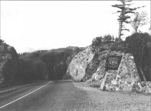
May 28. (See photo on following page.) CCC enrollees from Camp Gasquet complete the portal to the west boundary of what was then the Siskiyou National Forest, on Highway 199. Forty-four years later, a note stuffed in a Listerine bottle was found in the top cap of the portal monument; it read:
| |||||||||||||||
| 1938 |
Red Cap Fire on the Orleans District (Klamath NF) burns over 16,000 acres (Jarvi 8-8-52: 2). | |||||||||||||||
| 1939 |
September 1. Germany invades Poland precipitating the second World War. | |||||||||||||||
| 1940 |
Part of the High Prairie Creek watershed is approved as an experimental forest under administration of the California Forest and Range Experiment Station. Subsequently named the Yurok Redwood Experimental Forest. | |||||||||||||||
| 1941 |
CCC begins construction of the first 0.5 mile of the High Prairie Creek utilization road, beginning at the Yurok Redwood Experimental Forest headquarters. Survey is underway for the next 1.5 mile of the road. US enters World War II. Nation-wide, logging is stepped-up to meet war demands.
| |||||||||||||||
| 1942 |
November. Regional Foresters from regions 5 (primarily California) and 6 (primarily Washington and Oregon) discuss transferring Region 6's Gasquet Ranger District (part of the Siskiyou National Forest) to Region 5. | |||||||||||||||
| 1944 |
Red Rock Fire on the Mad River District (Trinity National Forest) burns over 10,000 acres (Jarvi 8-8-52: 2). California reaches a peak output of all types of lumber, cutting 2,468,943,000 board feet processed by 413 sawmills (DNT 1-25-46). | |||||||||||||||
| 1945 |
August 14. Japan surrenders; World War II ends. | |||||||||||||||
| 1946 |
January 1. Under provisions of California's Forest Practice Act, timber operators are now required to register with the State Forester. The Act divides California into four forest districts: Redwood, North Sierra Pine, South Sierra Pine, and Coast Range Pine and Fir. Registration is required for all operators cutting and removing forest products for commercial purposes; registration cost is $1.00 per year, and "[a]ny operator who fails to register shall be prohibited from cutting or removing forest products for commercial purposes from the forest lands" (DNT 1-25-46). U.S. Senator Sheridan Downey urges legislature to increase its $1,500,000 appropriation for construction of timber access roads in California national forests, and to include forest road appropriations specifically for Trinity County. Senator Downey notes that wartime timber harvesting had depleted accessible timber in Washington and Oregon and that California should look to Trinity County and other state areas to supply lumber (WTJ 1-17-46: 1). Arcata Chamber of Commerce forms a coalition committee of representatives from Arcata, Eureka, Blue Lake and Willow Creek to work on improving the western end of US 299 to prevent continued diversion of Humboldt County timber from the county to mills and plants in the Sacramento Valley and elsewhere. Between Willow Creek and US 101, Highway 299 is narrow, crooked, and has light surfacing (HT 3-21-46). Trinity and Shasta county representatives appear before the Collier Committee—the Senate committee studying the state highways, county roads and bridges of California. They plead for immediate allocation of funds for substantial improvements to US 299 from Redding to Arcata. Representatives cite the tremendous increase in heavy logging and lumber traffic that was rapidly making it a "menace to all other traffic on the road" (HT 6-13-46). Substantial improvements to the Hyampom to Hayfork Road are promoted. A petition to supervisors and planning commissioners for Trinity County note that improvements are crucial because of the "pressing need for a sufficiently improved highway capable of permitting logs and lumber to be hauled from this area." In June, Regional Forester S. B. Show met with local Forest Service officials to decide on roads necessary for future timber development in Trinity County. The Forest Service is looking at the possibility of improving the Hayfork Hyampom Road or a road from Grouse Creek to the coast (WTJ 6-6-46). February. Chief of the Forest Service, Lyle F. Watts, approves transfer of Gasquet Ranger District to Region 5. U.S. Representative Helen Gahagan Douglas introduces H.R. 6201, proposing creation of the Roosevelt Memorial Redwood National Forest. Confusion develops between the Douglas Bill, the NRPU, and the proposed national forest to be created from existing pieces of the Siskiyou, Klamath, and Trinity national forests. Transfer of Gasquet Ranger District made contingent upon creation of what would later be called the Six Rivers National Forest, rather than temporarily attaching it to the Klamath National Forest. September. Region 5's Brandeberry Report recommends final boundaries for the new national forest in Northwest California. October. Office space is leased for the new national forest in Northwest California. The office is on the third and fourth floors of the Bank of America Building at 350 E Street, on the corner of 4th and E streets in downtown Eureka. Region 5's Regional Forester, S. B. Show, issues a press release announcing establishment of this new, still unnamed, national forest to be headquartered in Eureka. November. "Six Rivers," as suggested by author Peter Kyne, is (finally!) chosen as the name for the new national forest. December. William F. Fischer is assigned to the Six Rivers as its first forest supervisor. He arrives on the job the 15th. | |||||||||||||||
| 1947 |
February. State Board of Forestry adopts forest practice rules for the Redwood Forest District (HT 3-23-47). Forest practice rules for the Coast Range Pine and Fir district become effective April 10. The California Wool Growers' Association, an organization which strongly opposes creation of additional national forest system lands, accuses the Forest Service of sponsoring the Douglas Bill. Supervisor Fischer told the organization that the agency was neutral on the bill (CR 5-7-47; HT 4-20-47). May 8. Senator Quinn of Eureka introduces a resolution in the State Senate memorializing Congress to defeat the Douglas Bill on the grounds it would decrease, by over half, the taxable areas within Del Norte, Humboldt, and Mendocino counties, plus eliminate about 85,000 acres from the taxable land base in Sonoma County (CR 5-14-47). May 22. State Legislature sends its Joint Resolution to Congress protesting the Roosevelt Memorial Redwood Forest bill (CR 5-28-47). June 3. President Harry S. Truman signs Proclamation 2733, establishing the Six Rivers National Forest, consolidating "certain portions of the Siskiyou, Klamath, and Trinity National Forests...." July. Six Rivers releases its report: "Forest Situation in Humboldt and Del Norte Counties, 1947." This report set the context for policies and practices for the forest's inaugural years. P.G. & E. begins its project to provide electricity to the Trinity River Valley—from Del Loma to Orleans—including Burnt Ranch, Willow Creek, Salyer, Hoopa, and Weitchpec. Klamath River Conservation Club circulates a petition to put an initiative on the ballot to regulate the dumping of mining debris in the Trinity and Klamath rivers. In 1924, Californians had passed an initiative creating the Klamath Recreational area, barring electric power dams and other obstructions. The impetus was to protect the tourism and fishing trade. (In Redwood Empire Labor Journal: the official publication for all American Federation of Labor Unions in Northwest California. Cf. 7-3-47, Vol. VII, No. 17, p. 1.) A survey by "Log and Saw" finds that, for 1947, employment in the lumber industry is at an all-time high in Humboldt County. However, they also note that some of the smaller operations were having difficulty paying their employees on-time. Demand for skilled workers in the industry is high, but there are fears that at least 40 percent of the 161 existing mills in the county will be defunct within three years and that jobs will be increasingly scarce. Wages have dropped about 10 percent from the all-time high in 1946. Lack of housing for new workers is a severe problem. Labor strikes are ongoing at many mills, though most of them are "humming" at or near capacity because of scab crews (HT 10-17-47). | |||||||||||||||
| 1948 |
Six Rivers' Supervisor's Office moves from the Bank of America Building to Third Street, between B and C streets, on the floor above what is Lenzi's Restaurant. The SO will remain at this location for about one year. | |||||||||||||||
| 1949 |
Some blister rust is detected on the Six Rivers, but no control work is planned because sugar pine is not sufficiently important to this forest (Cronemiller and Kern 1949: 20). | |||||||||||||||
| 1949 |
Allowable annual cut for 1949, including 11,000,000 board feet from the NRPU, is 150,000,000 (Fischer 6-16-49). Range values compose less than 20 percent of the Six Rivers' land area. There are 28 grazing allotments on the forest capable of 18,000 animal months; there are 48 permits in effect. Rates for grazing are figured in relation to meat prices and are currently running from 50 to 60 cents per animal per month (HT 3-13-49; Cronemiller & Kern 1949: 1, 30; Fischer 1950: 23). | |||||||||||||||
| 1950 |
Eighteen sawmills are operating within the Six Rivers administrative boundary with an annual capacity of 71,000,000 board feet (HT 3-13-49; Cronemiller & Kern 1949:1, 30; Fischer 1950: 23). The Six Rivers' SO moves to 23 Fifth St. It is located in a converted residence that looks very much like the neighboring building that will later become Kwan's Cafe. Spring. A joint Klamath-Six Rivers analysis looks into whether the huge, 585,000-acre Happy Camp Ranger District should be divided and another district added and headquartered at Somes Bar, or whether part of the Happy Camp District should go to the Orleans District. Given the first scenario, Somes Bar was seen as the only possible location on the Klamath, but it was nearly on the Six Rivers boundary line and only eight miles from Orleans (Cronemiller and Kern 1949: 32). | |||||||||||||||
| 1951 |
Six Rivers' receipts for the fiscal year are $152,471 from timber sales, $14,448 in grazing permits, $8,189 in other land use permits, and $335 in power permits. | |||||||||||||||
| 1952 |
Supervisor's Office moves to Fourth and J streets; this office is the first built especially for the Six Rivers. Six Rivers' allowable annual cut, including 12,000,000 from the NRPU's Requa working circle, is 138,604,000 board feet. Six Rivers' policy for Douglas fir in small, even-aged groups is to selectively harvest "with a view toward converting to the practice of clear cutting in blocks... in the minimum number of cutting cycles.... Stands with the highest proportion of over-mature and decadent volume normally will be scheduled for cutting first. Good risk mature and immature elements will be withheld from cutting whenever practicable, economic, and silviculturally desirable. Sales during the first cutting cycle will be directed toward the most rapid development of the primary transportation system, consistent with the allowable annual rate of cutting.... Short term sales (under three years) will be preferred. Sales will be programmed to dispose of the full allowable cut annually with 25 percent excess permissible in any one year provided the total of five-year periods does not exceed five times the annual allowable cut" (Bluff Creek Working Circle 1-31-52: 7,11). The basis for computing the annual allowable cut is a rotation of 150 years. Congress looks favorably upon construction of forest access roads during the 1950s. Working in cooperation with the California State Division of Highways and the Public Road Administration, the Forest Service takes a lead role in developing forest road projects. The Six Rivers, viewed as a virtually untapped timber resource due to a dearth of roads, becomes the recipient of Congress largess; with the implied message to produce timber sales accordingly. For example, a seven-mile stretch of two-lane road near Weitchpec, where the Trinity flows into the Klamath River, is earmarked by Congress to receive $1,000,000 for realignment and widening. Congress also designates $3,000,000 to partially realign and re-construct twelve miles of Highway 299 between Berry Summit and Willow Creek. Another forest road between Korbel and Hyampom is slated for construction in order to substantially reduce the 200 circuitous miles that separate Hyampom from Eureka (HT 3-5-52 and 3-5-52). Six Rivers receipts for the fiscal year total $236,268, "an all-time high." Fifty-five percent above the previous year's receipts, it marks the first time since its creation that the Six Rivers was financially "self-sustaining." Additionally, receipts from the Northern Redwood Purchase Unit total $50,252, also a record-breaker. The increase is directly traced to substantial increases in the cost of timber. The Six Rivers has collected $221,255 from its timber sales, $10,329 from grazing permits, $4,340 in other land use permits, and $343 in power permits. Twenty-five percent of these receipts are apportioned to the counties (HT 7-10-52: 1). Patrols by contract aircraft are used over the forest's Blue Creek area in cooperation with state forestry and the timber industry. Six Rivers personnel question its value, compared with fire lookouts, "because of the short period of actual detection obtained per day." Reconnaissance planes are used routinely after lightning storms (Jarvi 8-8-52: 16). The abandoned Bluff Creek Guard Station on Orleans Ranger District, consisting of an old two room cabin and a one car garage/storeroom, is no longer used. Regional Office inspectors recommend that the structures be "high graded for any salvageable material and the remains demolished and burned to make room for additional campground development. Any future needs for quarters in this vicinity should be made available at the Adorni Place." The Adorni Place was described as a tract of land recently acquired by the Forest Service, on the highway, about one mile below Bluff Creek. It had three or four acres of flat open land with a small orchard and meadow, and plenty of water. The improvements were described as "a good summer home type of dwelling and a 2 or 3 car garage" (Williams 1952: 3). RO inspector notes that, at Salyer Bar Ranger Station: "The conversion of the old school house building into a two room cabin is progressing OK... [and the] old shed and outside toilet on the schoolhouse site should be done away with." The inspector also notes that the residence on the station site and used by the dispatcher was "not owned by the Forest Service... it was constructed at the time and expense of the dispatcher." Also noted was that the old ranger station building at the mouth of Southfork, "although old and not well located, is in fair condition and is badly needed to help out the present acute housing situation. It is now being used by Timber sale men, but water must be hauled in [because the spring on the hill above the house had dried up]" (Williams 1952: 3-5). Mad River Rock Lookout—a standard 14' x 14' building on a large high rock, accessible only by a 120-step wooden stairway—is used infrequently. Because of limited local visibility from the lookout, it is recommended that the site be evaluated for elimination if the "new Trinity [National Forest] lookout tower for Pickett Peak can be placed on the point to the northwest of its present location" (Williams 1952: 3-5). | |||||||||||||||
| 1953 |
A diary analysis for the Orleans District Ranger, Yates, and his Assistant Ranger and Fire Control Assistant, indicate that the district's most serious problems are: 1. Keeping-up with boundary survey checks for trespass when private operators cut next to National Forest boundaries. 2. Failure of timber operators to complete contracts under specified time constraints. 3. Fraudulent mining claims. 4. Securing Forest Service rights-of-way. 5. Establishing special use residence tracts. 6. Inadequate campgrounds along the Klamath. 7. Lack of stream measuring devices. 8. Inadequate trail betterment. 9. Lack of progress with actualizing the station development plan. 10. Lack of a fireman station for the Doctor Rock lookout. 11. Lack of adherence to fire prevention. 12. Inadequate initial attack force at Orleans drawn from the local population; a request had yielded only 10 men under the age of 60 (Yates 3-19-53). The Six Rivers' actual cut for the fiscal year is only 30,000,000 board feet (Payne 1-20-54: 1). August. Lightning touches-off over 70 fires on the Six Rivers; 11 of them large enough or in places that are problematic. Lower Trinity and Mad River districts are hardest hit; the temperature hit 110-degrees on 12 August, making nerves even more jittery (HT 8-14-53: 1) | |||||||||||||||
| 1954 |
California's Governor Knight urges the Forest Service to step-up its road construction in the "Trinity timber area," which included some of the eastern fringe of the Six Rivers National Forest. Pointing to "over-ripe" timber that is "infested with forest parasites," he advocated pushing roads to access the timber heretofore economically unreachable. He supported harvest of decadent timber, believing it would promote growth of new trees and meaningfully contribute to the well-being of the region (HT 1954: unk.). | |||||||||||||||
| 1955 |
"The transportation bite out of the total forest budget is still running at about 20 percent" (West 1-12-56: 2). Arcata Redwood Company ceases clear cutting practices on its property (ARC 1973: 8). | |||||||||||||||
| 1956 |
Richmond-San Rafael Bridge completed. East Bay afforded much more convenient accessibility to the North Coast area. | |||||||||||||||
| 1957 |
A business recession begins and persists through 1958. It "affected not only the production of lumber, as shown by trade association figures, but also the number of sawmills operating in California. Twenty percent fewer mills were active in 1957 than in 1956—572 mills against 695, according to figures just compiled by the Experiment Station.... Comparison of the two sets of figures [1956 and 1957] shows that the smaller the size-class of mill in 1956, the lower the proportion of mills operating during 1957...
In spite of the shut-down of some active mills and the elimination of some operable mills, 63 new mills were operated in 1957, two-thirds of them in the Redwood Region. However, the 63 fell far short of replacing the 203 active in 1956 which became idle or non-existent in 1957 [at least in terms of numbers of mills]." Of the 669 mills existing at the end of 1957, the Pine Region claimed 290, and 379 were in the Redwood Region (USDA, FS, CF&RES 1957). | |||||||||||||||
| 1959 |
Newton Drury retires as Chief of the State Division of Parks and Beaches. At least since the 1920s, he had been very active in the Save-the-Redwoods League and had held office in that organization for many years. | |||||||||||||||
| 1960 |
June 12. Congress passes the Multiple Use-Sustained Yield Act. It declares: "The National Forests are established and shall be administered for outdoor recreation, range, timber, watershed, and wildlife and fish purposes." MUSY directs the Secretary of Agriculture "to develop and administer the renewable surface resources of the national Forests for multiple use and sustained yield of the several products and services obtained therefrom." | |||||||||||||||
| 1960 |
After experimenting with the clear-cutting practices applied to company property prior to 1955, Arcata Redwood Company deems that clear cutting "best fits the tree species, terrain, soil, weather and other conditions existing on the property the company owns and manages." Further, company officials conclude that the best practice is to immediately follow clear cutting with spot burning to substantially reduce the fire threat, and that "exposure of mineral soil during logging and spot burning has developed highly effective seedbeds for new crops." They also report that helicopter reseeding after logging "has produced the desired species mix on company property" and that "streams and water quality can be effectively protected under clear cutting as well as under any other logging method" (ARC 1973: 8-9). Nationally, Forest Service timber sales reach an all-time high of 12.2 billion board feet. From 1950 to 1960, National Forest timber harvest increases 2.7 times and cash receipts 4.8 times. In the same period, National Forest recreation more than triples to a record number of 92.5 million visits (USDA, FS 1960: 5-6). | |||||||||||||||
| 1962 |
May 1. Harvest on the NRPU lands of the Turwar Ridge Sale commences; it is completed June 21 and burned October 1. The sale was on nine acres with a 65 percent average slope; 800 mbf were harvested with a 20 percent cull. | |||||||||||||||
| 1963 |
May 10. Harvest begins on the Mypaw Sale, on NRPU lands. Cutting is completed August 15 and burned October 7. Sale area average slope was 60 to 70 percent; 1.246 mbf were harvested. | |||||||||||||||
| 1964 |
September 3. The Wilderness Act becomes law. Under provisions of the Act, about 10,000,000 acres in 60 areas managed by the Forest Service were set aside as wilderness. The Act also directs the agency to study 35 additional Primitive Areas and to make recommendations as to each area's suitability for inclusion in the national Wilderness Preservation System. The Salmon Trinity Alps Primitive Area with parts of it on the Shasta-Trinity, Klamath, and Six Rivers national forests was one of the study areas. It had been established as a Primitive Area in 1932. (Cf. "A Wilderness Reclassification Study, Salmon Trinity Alps," California Region pamphlet, n.d.) | |||||||||||||||
| 1966 |
In about this year, the Supervisor's Office is moved to 710 E Street at the corner of 7th and E streets in Eureka. This building is built expressly for occupation by the Six Rivers National Forest. Congress passes the National Historic Preservation Act. | |||||||||||||||
| 1969 |
Congress passes the National Environmental Policy Act. | |||||||||||||||
| 1971 |
April 5, CBS reporter Richard Threlkeld broadcasts a story on Walter Cronkite's Evening News, one of the most watched news programs on television. Threlkeld strongly criticizes Forest Service management, particularly on the Six Rivers National Forest. Among other statements in the story, he comments: "On the backroads of the Six Rivers Forest whole mountain sides of virgin timber have been cut away leaving nothing but rocks and dirt." Regional Forester Douglas Leisz hotly argues the story with CBS President Richard S. Salant, contending that Threlkeld had chosen an area predominantly on private land and that, moreover, the statement was false. Salant countered that Threlkeld and his crew had not filmed "a single scene from any area which was privately owned or logged during private ownership." Further Salant said that Threlkeld had sought unsuccessfully on the Six Rivers to "find a single young growing tree even of pencil size" on clear-cut areas. Salant closed by saying that "Mr. Threlkeld has traveled through dozens of national forests and he informs me that he has never seen one that suffered from the neglect and the evidence of man's encroachment that is represented by the Six Rivers area" (Salant 5-5-71). Further incensed, Leisz—who had earlier in his career served as Ranger on the Lower Trinity District—persuaded Threlkeld to revisit the Six Rivers and other northern national forests. Accepting the invitation, the four day trip started September 27. While on the Six Rivers, they visited the unit on the Little Jones Sale that had prompted the reported lack of restocking after clear-cut. The California Log reported that the group "found that the block previously chosen by Threlkeld... had a stocking level of 1,000 trees per acre." Threlkeld, after noting the land lines in the field trip, also said that, indeed, private land had been included in the film. The group discussed soil stabilization problems associated with clear cutting on steep areas (CL 10-25-71). Though the written communication from Threlkeld following the trip was not in file, an October 22, 1971 letter from Doug Leisz to Mr. Salant praised Threlkeld for his objectivity on the second trip, noting that the group and seen some of the bad as well as the good. He lamented that the broadcast on the Cronkite show had misinformed the public but was heartened by the latter "open exchange of views and searching out of facts" (Leisz 10-22-71). | |||||||||||||||
| 1973 |
California's Z'berg-Nejedly Forest Practices Act becomes law, increasing public regulation of private logging. | |||||||||||||||
| 1974 |
Six Rivers ranks fifth in Region 5, both in total collections and in timber receipts out of the total of 17 national forests, behind: 1. Lassen, 2. Shasta-Trinity, 3. Plumas, and 4. Klamath. Sierra Club appeals the Six Rivers' contract to construct the Dillon-Flint Section of the Gasquet-Orleans Road. Sierra Club contends that the 6 to 8-mile road extension intrudes into roadless land, is a major Federal action under the National Environmental Policy Act, and therefore, should have been covered by an Environmental Statement rather than the analysis that was done; also contends that the Six Rivers' analysis documentation did not meet requirements of the Multiple Use Sustained - Yield Act. | |||||||||||||||
| 1975 |
Wintu and Wailacki descendants living in Hettenshaw Valley area oppose Forest Service proposed road construction in the vicinity, contending that the timber road would violate an Indian burial ground, squander fishing resources, and open the area to further vandalism and depredations (Wassaja 10-75). The Six Rivers attempts to address Native American opposition to construction of the Gasquet-Orleans Road by proposing designation of the entire area as a National Historic District, with preservation of the major ceremonial sites protected by a half-mile radius buffer. November. Sierra Club and Forest Service settle a suit regarding the adequacy of the Final Environmental Impact Statement for the Fox Planning Unit on Jones and Hurdygurdy creeks near the South Fork Smith River. The FS agreed to undertake various detailed studies and long-term monitoring programs to determine the environmental effects of the proposed timber harvest units. There was a resulting five-volume report. Forest Service engineers, Farrington and Savina comment that: "Landslides associated with clear cutting alone can also produce downslope effects, but our observations suggest that individual slide volumes from vegetation removal are one to two orders of magnitude less than slides associated with roads." | |||||||||||||||
| 1976 |
National Forest Management Act directs forests to develop plans that guide all management for 10 to 15 year periods. | |||||||||||||||
| 1979 |
The Six Rivers commissions an ethnographic, historical, and archaeological study of the Gasquet-Orleans Road area; the results lead to a recommendation that road construction and log hauling in the area be ceased. The Forest Service, however, argues that national economic interests should take precedence over Indian cultural interests and continued to pursue the G-O Road completion. | |||||||||||||||
| 1980 |
Six Rivers Forest Supervisor Joe Harn appeals to the County Board of Supervisors to do what it can to help protect Forest Service employees in the Orleans area. He notes that employees' lives are filled with intimidation and harassment. He says two federal special agents have been assigned to the area because of the growing friction in the community. Harn believes part of the blame resides with the local marijuana industry. One Supervisor believes part of the problem has to do with people who are against the Forest Service's use of herbicides. Harn notes that about 40 percent of the forestry positions in Orleans have gone unfilled "because of the reputation the area has as a bad place to work" (TS 9-3-80). An arsonist starts several fires on Gasquet RD, including a 109-acre fire behind the Patrick Creek Lodge. Sierra Club proposes designating a 171,500 acre area in the Siskiyou Mountains for wilderness, including portions of the Siskiyou National Forest in Region 6, and the Klamath and Six Rivers national forests in Region 5. Within what is termed the Siskiyou Study Area, inventories will be made of the area's wilderness, recreation, wildlife, water, forage, timber, minerals, and soils resources as well as inventories of existing land uses and the anticipated social effects of various alternatives (USDA, FS 1968). Department of Interior's Heritage Conservation and Recreation Service makes available for public review its Draft Environmental Impact Statement for including the Klamath, Trinity, Smith, Eel, and lower American rivers into the National Wild and Scenic Rivers system. Totaling 4,000 miles, these rivers are already included in the California Wild and Scenic Rivers system. | |||||||||||||||
| 1982 |
A coalition of environmentalists, most notably the Sierra Club, joins with Indian individuals and organizations to bring suit against the Forest Service for its planned construction of the Gasquet-Orleans Road on the grounds of religious freedom as well as on the grounds of environmental issues. | |||||||||||||||
| 1983 |
May. Judge Stanley Weigel of the Federal District Court of Northern California rules on the Northwest Indian Cemetery Protective Association v. Peterson. His decision said that construction of the Gasquet-Orleans Road through public land held sacred by the Yurok, Karuk, and Tolowa would seriously undermine the Indians' right to free exercise of religion. It is a groundbreaking decision that affirms protection of Indian sacred sites on public land under the First Amendment. The G-O Road runs about 50 miles over the Siskiyou Mountains; on completion of a seven mile connection near the center of the route, it was to provide a key transportation link for that quadrant of northwestern California. Though early on, some Native Americans objected to completion of the G-O Road, administrative appeals and legal suits against the project were initially filed by environmentalists on the basis of environmental issues. The religious use is largely meditational and hinges on the near-natural condition of the surrounding environment. When the case reached District Court, Judge Weigel linked environmental issues with Indian religious freedom... ruling that essential environmental components were key elements in Indian religious freedom. He also found no national interests sufficient to override the plaintiffs' First Amendment rights (Buckley 1983: n.p). | |||||||||||||||
| 1984 |
About 128,000 acres is designated as wilderness on the Six Rivers National Forest under provisions of the Wilderness Act. | |||||||||||||||
| 1987 |
Six Rivers National Forest releases its Draft Land and Resource Management Plan in accord with the National Forest Management Act. | |||||||||||||||
| 1990 |
Smith River National Recreation Area Act passes to preserve, protect, and enhance recreation values of the Smith River area. The northern spotted owl is listed as a threatened species. In a resultant law suit related to Forest Service management of the owl, the Forest Service is enjoined from logging any suitable northern spotted owl habitat in the Pacific Northwest until an environmental assessment is completed under the National Environmental Policy Act. This injunction immediately drops logging levels to record lows throughout the Pacific Northwest, including the Six Rivers National Forest. Six Rivers withdraws its Draft Land and Resource Management Plan as a result of establishment of the Smith River National Recreation Area and listing of the northern spotted owl as a threatened species. | |||||||||||||||
| 1992 |
Long term price trend per thousand board feet of lumber for the Six Rivers spirals from below $50 in the early 1970s to over $350 in FY 1992. American Fisheries Society identifies 214 stocks of anadromous salmonids in need of special consideration because of low or declining numbers. Twelve of these stocks are found in habitat managed by the Six Rivers National Forest. This leads to the eventual listing of steelhead and coho salmon as threatened species in 1997. Marbled murrelet, whose habitat includes portions of the Six Rivers, is listed as a threatened species. | |||||||||||||||
| 1993 |
April 2. President Clinton convenes the Forest Conference in Portland, Oregon to "stop the train wreck" and address the "human and environmental needs served by the federal forests of the Pacific Northwest and Northern California." Clinton directs his Cabinet to develop a long-term policy for federal forest lands in this region. | |||||||||||||||
| 1994 |
The Northwest Forest Plan is released in response to direction provided by President Clinton in the 1993 Forest Conference. The plan also resolves the 1990 lawsuit regarding management of the northern spotted owl. The plan is the first large scale, inter-agency effort in ecosystem management; it addresses the needs of a wide range of species dependent on late-successional and old-growth habitat, including the northern spotted owl and the marbled murrelet. The plan includes social and economic strategies in its ecosystem approach in order to provide for human communities hardest hit by plummeting timber harvest levels. | |||||||||||||||
| 1995 |
Six Rivers releases its Land and Resource Management Plan. The plan incorporates direction from The Northwest Forest Plan and reflects the shift in Forest Service policy away from maximization of timber yields and toward ecosystem management. |
| <<< Previous | <<< Contents>>> | Next >>> |
|
5/six-rivers/history/app1.htm Last Updated: 14-Dec-2009 |