|
The Land We Cared For... A History of the Forest Service's Eastern Region |
|
CHAPTER VI
THE GREAT DEPRESSION AND NEW DIRECTIONS
The Great Depression with all of its tragic consequences hit rural America quickly after the stock market crash of late October 1929. Rural areas, which had not really shared in the high-flying prosperity of the 1920's, now found themselves in deep depression. Farmers, who were already in a recession caused by overproduction and low prices, were now faced with mortgages they could not hope to pay and farm prices which were less than the cost of production. The lumber industry suffered the same woes. Mining, particularly coal, had gone into a depression in the mid-1920's because of declining use of coal and overproduction. When the Great Depression struck, many coal towns in Pennsylvania, West Virginia, and Illinois became what the New Dealers euphemistically called "stranded." Things were so bad that there were no jobs and nowhere else to go. In some of the coal counties of southern Illinois unemployment reached 75%. [1]
The impact on local communities and economies was disastrous. Banks closed and depositors could not withdraw their money. City and county governments could not meet their obligations because people could no longer pay their taxes. School districts paid their teachers in script and postdated warrants. Business failures and farm foreclosures were the order of the day, and a whole new class had been created in the country—the new poor.
The coming of the Great Depression changed America's way of thinking. The people had to come face to face with harsh realities. Politicians and intellectuals alike had to recognize that America was no longer the promised land and that something had to be done immediately about the problems of unemployment, business collapse, hunger, and poverty.
Naturally, in the atmosphere of desperation and disillusionment of the 1930's, political leaders had to offer new reforms, not only to help those who could not help themselves, but to remake the old system so that such a depression would never happen again. The New Deal of President Franklin D. Roosevelt, which began with the Hundred Days Legislation of early 1933, set the nation on a new course toward federal responsibility for the economy and the welfare of the citizens.
Some of the most important reforms of the New Deal came in agriculture, and several of them had an impact on the Forest Service and the National Forest System. A series of Agricultural Adjustment and Soil Conservation Acts passed in the New Deal years were aimed at eliminating agricultural overproduction by drastically reducing farm acreage in production. Farmers contracted to not cultivate up to 40% of their land, and these Agricultural Adjustment Act (AAA) programs, combined with price supports, saved many farmers from failure and foreclosure and kept much farm land in production. [2]
While the AAA programs had little direct effect on the National Forest System, several other New Deal programs certainly carried secondary implications. The Norris-Doxey Cooperative Farm Forestry Act of 1937 provided technical aid to farmers to manage their woodlands. [3] The Bankhead-Jones Farm Tenant Act of the same year, with its primary goal of alleviating farm tenancy, began several new programs which allowed the federal government to acquire wasted lands, some of which ended up in National Forests. [4]
The Resettlement Administration had a program of relocation and land acquisition which began in 1935 and continued under the Farm Security Administration (FSA) after 1937. [5] A 1937 report by Chequamegon National Forest Supervisor, Chester L. Van Giesen, explained the predicament of numerous families, particularly in Bayfield County, Wisconsin, trying to farm submarginal farm lands. As their farms were purchased by the Farm Security Administration and the Forest Service, the families were moved to an 800 acre site near Drummond, Wisconsin, where they received individual 20 acre farms. The farms had homes, barns, garages, running water, and baths. The plan was to provide the men part-time forest work on a permanent basis. This stable, trained work force would aid the Forest Service, by working 180 days in various jobs. But the lure of better jobs or the draft of World War II brought an end to this resettlement community. [6]
The FSA had a land program that worked in conjunction with the Forest Service, exchanging lands back and forth to meet the needs of the two federal agencies. In some of the same ways, the Federal Emergency Relief Administration had land programs which allowed destitute farmers to take up subsistence homesteads on government land. These programs eventually led to exchanges of land with the Forest Service. [7]
There were two New Deal programs which dealt directly with the National Forest System, both of which began in 1933. One was the Civilian Conservation Corps (CCC), which will be discussed in Chapter VII. The other was a far-reaching expansion of the National Forest System, especially in the East. This momentous policy change was given its direction by "National Plan for American Forestry," a master plan developed by the Forest Service and submitted to Congress as an Omnibus Forestry Bill. Even though the Washington Office staff and leaders of the Forest Service did everything they legitimately could to encourage its passage, the Plan never made it through Congress. It was, nevertheless, a profoundly influential document in the Forest Service for years to come. [8]
The Plan had two goals: a large extension of public ownership of forest lands and more intensive management on all forest lands. [9] When these general principles became firmly fixed in Forest Service thinking, the wheels were set in motion for the creation of eight new National Forests in the Region. Since the new land acquisition program was directly connected to the land ownership problems of the Great Depression, the Forest Service became part of a major New Deal effort to aid American farmers.
The hope was that the purchase of submarginal land by the Forest Service and other government agencies would put money in the hands of farmers so they could survive the Depression. In the process, the Forest Service now found itself dealing with a whole new class of people. Instead of large landowners such as lumber companies and railroads, it was now dealing with distressed and bankrupt farmers, tenants, and squatters. The Service was now involved in a completely new role—one of trying to help solve the social and economic problems of the individual landowners of the most depressed areas of the country.
When the Forest Service began acquiring land that had once been in private hands, it faced a new kind of land management problem. Formerly, most National Forests had been created out of government owned land or wasted and cut-over land purchased from lumber companies, large private owners and land jobbers. Now the Depression had created a new situation. Because of the agricultural depression, land was so cheap to buy that the government could purchase small tracts, in effect the farms of failed farmers, if such lands qualified under the Weeks and Clarke-McNary Acts.
Tragically, the Great Depression had brought an agricultural disaster never before seen. By 1930 or 1931, many farmers who once had been reasonably successful were facing ruin. Debts for operating expenses, new equipment, and expansion made in the 1920's were now insurmountable. Throughout rural America, the story was the same: hundreds of thousands of farmers losing their farms and falling into tenancy, sharecropping, or being completely displaced from the land. The situation was particularly bad for upland farmers whose lands were less productive. Government benefits from the AAA programs were based on previous production, so upland farmers received less help than bottom land and prairie farmers. [10]
In many of the upland areas such as the Ozark Highlands of southern Missouri, the Green Mountains of Vermont, and the hill country of southern Illinois and Indiana, farmers and other landowners lost their lands to banks and mortgage companies in wholesale amounts. Often, the land became so worthless on the local market that the owners did not pay the minimal local taxes, and large tracts of land could be purchased from the counties. The Depression was so severe in many parts of Regions 7 and 9, that literally millions of acres could easily be bought at prices from two to five dollars per acre. [11]
This situation was in the minds of those who formulated the plans for development of new National Forests in the areas where so much inexpensive land was available. For Congress, the land purchases were more of an anti-depression measure. For the Roosevelt Administration, the purchases were a visible sign of its willingness to help the "forgotten man". For the leaders of the Forest Service, land purchases were a golden opportunity. Chief Ferdinand L. Silcox exhorted the Service Committee and indeed the entire Service to make an extraordinary effort to take advantage of the situation. If ever there was time to act to complete the National Forest System, it was now. [12]
Regional Forester Joseph C. Kircher took up the cause immediately. In the Courier, he pointed out that the Forest Service and Region 7 were both growing rapidly during this eventful period. On October 30, 1933, an additional 823,737 acres of forest land was acquired by the Region, bringing the net acreage of the Region to 6,528,851. This was an increase in size of 22% in six months, yet the Regional Forester predicted that the growth would be even faster in the next six months if the Region lived up to his expectations. He believed that the Region should be at 10 million acres by July of the coming year. Such growth would not simply happen. It would require "a lot of hustling and a lot of teamwork." The Region would have to become "acquisition minded." Kircher told the Region: "It is a golden opportunity to consolidate, to build up real National Forests. It cannot be done from my office, nor can the special acquisition men do all of it. It is a job for every one of us, and the administrative men who have most to gain should be active in this field."
To illustrate the full extent of the opportunity, the Regional Forester pointed out that there was, "enough money" to create better National Forests and to develop those already established. Also, the CCC was available to do the needed work and the Roosevelt Administration strongly supported the effort. "Never before," said Kircher, "have we had a better chance for public service, and I know we are grasping it." [13] Subsequently, as a reaction to the agricultural depression and not as a conscious decision to do so by Congress or the architects of the New Deal, the federal government entered a massive program of buying land as a relief and conservation measure. Regional Forester Kircher had been right. It was a golden opportunity for the Forest Service. It is altogether possible that without the Great Depression, many National Forests would never have been created and millions and millions of acres of land would have remained in private hands to this day.
To understand the anti-Depression motivations of the government, it is necessary to look into the economics of the Great Depression. The most serious problem of the time was a critical shortage of money, not only in the general economy but in local economies. The New Deal solution for this problem was injection of money into the economies by various emergency relief measures. Forest Service purchase of land from distressed farmers would, so the theory went, not only put money in the hands of consumers but also provide money to circulate in local economies. An extension of the same argument was used to justify the creation of new National Forests. This would not only put money into circulation through the purchase of land but would create jobs and, in the long run, broaden the economic base by restoring the timber resource.
Depression Purchase Units
Throughout all of the purchase procedure and in the assumption of control, no coercion was used by the Forest Service. The policy was always to find willing sellers. The "power of condemnation" was never exercised. There were, expectably, some mishandlings and injustices as there always are in such massive operations.
Because they were now buying land from smaller landowners, the purchase agents were not able to put together large, solid blocks of land. Instead, the purchase units of this period looked like crazy quilts. Often, the government was able to acquire no more than half of the land in a purchase unit. The problem here was that although farmers and landowners were depressed, they had not lost their senses. They tended to sell to the government the less productive land and keep for themselves the better land. Government land purchases were an opportunity for landowners to sell their less productive lands. In addition, quite a few landowners had the foresight to retain the mineral rights to the land they sold. Unfortunately for the future management of these lands, the Forest Service was under such pressure to buy land that it purchased surface without mineral rights.
Resigned to the reality that they could not acquire large blocks of land without private owners retaining some of the land, the National Forest managers had to strive for ownership patterns which protected the Forest resources, permitted reasonable public recreational use, and was, at the same time, efficiently manageable. Since a large part of the land within a National Forest (often as much as half) was still being used for some private purpose, whether agricultural or recreational, the Forest Service had to be concerned with how its management of the land affected the private owners and the local economies, including the communities within or near the National Forest. It soon became clear that federal ownership could not be a static condition and it would have to adjust to changing regional social and economic needs. What the Forest Service prefers to call "land ownership adjustment" was, and is, a never-ending process. [14]
Managing the Depression Forests
A new management problem the Forest Service now faced was dealing with the people who were left on the land after the government had bought it. They could be the actual landowners who had sold in desperation but who really had no place else to go. They also could be tenants on the land who had no part in the sale but had lost tenure on the land by the sale. They could even be squatters who had no legal rights at all but who also had no place else to go. The Forest Service had to deal carefully with these situations. The Service could not afford to be in the position of forcibly evicting families from the land and turning them out into the nearly hopeless economy. A group of evicted tenant farmers in the Missouri Bootheel staged a demonstration by camping along a federal highway in 1937. They attracted enough national attention that the Roosevelt Administration was forced to act. The New Deal was sympathetic to those the liberal press called "the disinherited" and the leaders of the Forest Service had enough political awareness to position the Service accordingly.
The most sensitive cases dealt with tenants and squatters. The Forest Service needed great patience and forbearance with some of these cases, and occasionally the situation required a certain amount of courage on the part of field personnel. When the Forest Service purchased large tracts of land from timber companies, as was the case in the Mark Twain National Forest, there were often squatters who had lived on the land for years, even generations. If they were old, they were often allowed to live out their lives on the land as tenants with the understanding that when they died their cabins would be razed. If the family was younger, they were offered temporary permits. In some rare instances where the land was still suitable for farming, the Forest Service constructed new houses, out buildings, and outdoor privies. In the Ozarks of the 1930's, privies were considered a new fangled luxury by many rural people.
Most of the land acquired by purchase was too exhausted or cut-over to be used for farming, so the District Rangers had to try to move the squatters off the land or place them under permit. Either way, the squatters looked upon it as unwarranted government interference in their lives. [15] It was not unheard of for a squatter or tenant to meet the threat of eviction with a rifle in his hand. Even a visit by Forest Service personnel could evoke a violent response. To ease the transition from private to public land and the squatter-tenant problems, the Forest Service developed a policy that was lenient toward people still occupying the land. In effect, the Service became a landlord by granting to such people special use permits, sometimes for the payment of a small fee and sometimes free. In 1934, the Service established a policy that anyone could continue to occupy National Forest land by obtaining a special use permit and paying a fee, usually slightly less than the taxes would have been if they were still being paid. Even with this liberal policy there were problems. As landlord, the Forest Service now had to make the tenants obey rules and regulations intended to control timber cutting, prevent fires, and dispose of trash. Former landowners who had always decided such things themselves resented these controls. [16]
After several years of dealing with squatter-tenant problems, Region 7 had not handled matters to the complete satisfaction of two Washington Office inspectors. The inspectors visited the George Washington and Jefferson National Forest in Virginia and became concerned that Region 7 was "not doing enough" for the poverty-stricken Appalachian people who had sold their land to the Forest Service and still remained on it as tenants. On these two National Forests, the inspectors thought Region 7 had done too much in developing recreational resources. They seemed to believe that a better balance should be struck between these expenditures and money spent on upgrading the property occupied by tenants. [17]
Impact on Local Economies
The conversion of close to 500,000 acres of agricultural and timber land into National Forests had important effects on the local economies. There was fear in some localities that the coming of federal management would bring new controls on the lives of locals and limit their use of the woods. There were local organizations which resisted the change, but there were also local civic and political groups which encouraged it. One problem which emerged was the decline in tax collections by counties which had thousands of acres of land taken off their tax rolls when the federal government purchased it. [18]
There were also new types of problems in dealing with the small landowners who were left as in-holders within the National Forests. Their boundaries and acreage were not known exactly and often had to be surveyed. Occasionally, there were law suits which had to be settled in court. Land title problems were complex for lands which had been patented as many as 200 years earlier. Often, the property had changed hands many times over the years, and each transaction had to be verifiable in court or else the title was not clear. [19]
Forest game management in the new National Forest areas was an immediate problem. Since frontier times, local people had hunted and fished freely in certain areas which were now in the National Forests. Now, to hunt and fish legally, they had to obtain state licenses and were sometimes restricted from hunting in wildlife reserves. Where there were Indians in the locality or where Indian lands were involved in the creation of the National Forest, as was the case on the Chippewa National Forest, there were special treaty rights problems. [20]
In 1940, the Manistee National Forest conducted a study to determine the effects on the local economy of "woods work," that is, the manufacture and distribution of forest products, and work relief in the forest such as CCC and WPA. Also included in the study were people living within the boundaries of the Manistee who were on relief. The study, as reported by Supervisor Wellington I. "Bob" White, found that 6,000 residents of the Manistee were dependent on woods work for their livelihood. It also showed that agriculture and industry supported only 60% of the Manistee's total population of about 15,000 people. Of the 3,147 families living on farms within the Forest, only 1,392, or 44% gained their primary living from farming. Of the others, 27% obtained part of their living from agriculture, and 29% received no appreciable support from their farms and were therefore dependent on forest work or relief.
The Manistee study attempted to determine why farm families were living on the farm but not really farming it and concluded that these were farms where the land was so poor that no living could be made from it in the depressed agricultural economy of 1940. The report concluded that if all of the poor land not being farmed could be planted to trees, either by individuals or by the state, local, or federal government, the tree crop would eventually provide a local living for a great many more people and reduce the relief load in the area. [21]
The New Forest Ranger
The role of Forest Ranger in the Eastern Region evolved into something quite different from his or her western counterpart. In the Eastern Region, Rangers were more likely to live in the very communities which were most affected by the National Forest instead of in Ranger compounds as was the practice in the West. As a result, eastern Rangers became more involved in their communities and more visible to the public. They had new types of problems to face—those of acquisition, boundary, mineral rights, tenants, wildlife restoration, and intentional fire setting by locals. In addition, timber thievery was more common and easier to do in the Eastern Region because of the patchwork pattern of ownership. In general, the new breed of Forest Ranger in the Eastern Region spent less time riding the range and more time in the office doing paperwork and dealing with people. The Ranger's basic responsibilities remained the same, but the way of going about the job had changed. [22]
Even if the role of Forest Ranger had become a bit more prosaic, the Forest Service still had a romantic image with the public. One sign of this was a letter written in 1940 by Bill Wood, a 14 year old boy of Peoria, Illinois, who wrote to Region 9 asking for authority to form a junior version of the Forest Service. The new organization would be made up of boys clad in forest green uniforms and meeting regularly at a public recreation center. There would be two categories of members—12 to 16 year olds and 9 to 12 year old boys. Young Bill asked also for a book from the Forest Service which would explain what the Forest Service did. "I have decided," he wrote, "with the help of our board of directors, that this book should be studied and learned enough to pass a test on it." Regional Forester Jay H. Price answered that he had no authority to authorize a new branch of the Forest Service, but he did not want to discourage young Bill and his efforts. He offered his help in any way possible, and he immediately sent the books which Bill had requested. [23]
A good example of a role model for the new Forest Ranger in the East was Jack Horner, the District Ranger for the Washburn District, Chequamegon National Forest. Horner, whose curious name was enough to attract attention, carried on a steady campaign to improve relations between the Forest Service and the local community. He wrote a series of articles for the Daily Press of Ashland, Wisconsin, entitled "Beauties of Our U.S. Forest Areas." While the articles could certainly pass for good nature writing, they also did much to explain what the Forest Service had done in the past and aimed to do in the future. [24]
Among Ranger Horner's other tactics were organizing tours for local leaders and newspaper editors and speaking at service clubs. After getting Horner's treatment, one editor wrote the following: "Northern Wisconsin is most fortunate that the U.S. Forestry Department is on the job. Not only do they replant trees in a gigantic reforestation project, they prevent forest fires and quench them when they do start. They improve beauty spots, make safe, comfortable, all weather roads from one beauty spot to another. We take our hats off to that governmental department so well represented locally by Jack Horner." [25]
Sometimes a little good humor would go a long way toward solving the problems of dealing with local people. J. P. Campbell, editor of the Prospect News of Doniphan, Missouri, had been an ardent critic in his editorials of the Forest Service and many of the actions of the Clark National Forest, currently the Mark Twain National Forest. Campbell was also a leader of a group of residents of the Fristoe Ranger District who had organized to bring a grievance against the Forest Service for the inauguration of a range management program on the Clark.
One Sunday in 1940, while hiking in the Clark, Campbell came upon a lookout tower and decided to climb it. When he reached the top, he found a young man named Ed Cunningham, the Towerman, who showed him the sights. Before Campbell left, Cunningham asked him to sign the guest book which he kept because he had so many visitors on Sundays. He then gave Campbell a card and a certificate which made him an official member of the "Ancient and Honorable Order of Squirrels." The certificate like the whole Squirrel Order, was Cunningham's own invention. It read as follows: "This certifies that on May 30, 1940 Mr. J. P. Campbell climbed the Briar Lookout Tower guarding the Clark National Forest against fire. He is therefore recognized as a member of the Ancient and Honorable Order of Squirrels." (signed) Cunningham, E. Towerman. In signing as a member of the Order of Squirrels, Campbell pledged to "be careful for the fire in the woods as I work, as I walk, as I ride." The pledge ended with, "As I so subscribe, I am therefore a squirrel." Campbell was so amused by all of this that he published an account of it in his newspaper, including the Squirrel Pledge. He remarked that his attitude toward the Forest Service had been greatly improved by the experience, and his criticism was thereafter considerably blunted. [26] The cards were still being issued as late as 1970.
Forest Histories
The National Forests created under the special conditions of the Great Depression in the Lake States Region, (Region 9) and which came to be a part of the new Eastern Region, (Region 9) were as follows: the Ottawa, Green Mountain, Nicolet, Chequamegon, Wayne-Hoosier, Manistee, Shawnee, Mark Twain and Clark.
Ottawa National Forest
The Ottawa National Forest lies between Lake Superior and Lake Michigan, which were known to the Native Americans of the region as "gitche guam" and "mitche guam," big waters and small waters. [27] One of three National Forests in Michigan, the Ottawa was established in 1931 out of the Keweenaw Purchase Unit administered from Munising, Michigan. Munising was the headquarters for the Michigan National Forest which had been established in 1909. Between 1924 and 1928, W. W. Ashe from the Chiefs Office had made general reconnaissances of the Lake States area for additional lands suitable for National Forest purchase. By 1928 enough prospective acreage was found, mainly in Houghton and Iron Counties located in the far western portion of the Upper Peninsula, to establish the Keweenaw Purchase Unit. [28]
Much of this land was bought from timber companies who were eager to sell. Even before the Keweenaw Purchase Unit was approved by President Herbert C. Hoover, the Forest Service received from the Von Platen-Fox Company an offer to sell approximately 35,000 acres for $1.50 an acre. The same price was asked for 12,000 acres offered by the Weidman Lumber Company. [29]
Between 1928 and 1931, some 80,000 acres were acquired for the Keweenaw, comprising mostly cut-over and burned lands. In May of 1930 the Chief's Office suggested the possibility of proclaiming the three Purchase Units: the Marquette, Mackinac, and Keweenaw, separate Forests and solicited suggestions for names. The proposed names were: Hiawatha, Ojibwa, De Soto, and the favorite, Ottawa. The Ottawa were an Algonquian tribe who in the preceding century had been pushed north by the Iroquois.
Establishment of the three National Forests came about only through the cooperative effort of the Forest Service and the citizens of the Upper Peninsula Development Board, particularly George E. Bishop. [30] The dedication of the three forests: the Marquette, Hiawatha and Ottawa, took place on September 20 and 21, 1931. By this time the Forest occupied land in four Michigan counties: Ontonagon, Houghton, Gogebic, and Iron. Two huge land additions were made in 1933, totaling 464,500 acres in the original four counties and Baraga County. [31] Active promoters of these additions were Ex-Congressman Frank E. Hook of Ironwood; W. C. Janson, former editor of the Daily Globe; Donald R. Cotton, a large landowner of the Lake Gogebic area; and Linwood I. Noyes of Ironwood and publisher of the Daily Globe. [32]
An additional million acres were proposed to the National Forest Reservation Commission for approval as the Lake Gogebic Unit in 1935. Regional Forester Earl W. Tinker argued before the Commission for the establishment of this purchase area, informing them that it was the necessary step to halting the process of "economic desperation." Tinker explained that the 20,000 inhabitants who were dependent on wood-using industries would join the half of the population already on relief rolls if sustained yield management of the Forest was not enacted quickly. Even those land owners who practice sustained yield forestry programs, Tinker argued, were in dire straits financially because their larger trees were taxed as virgin timber, a situation they could not afford. After some further discussion of the proposed costs of purchases in the Lake Gogebic Unit (between $9 and $10 million), the motion was carried to approve its establishment. [33] This area was included in the Ottawa National Forest in 1935.
Also in 1935 the James W. Toumey Nursery was established at Watersmeet. Toumey was Professor of Forestry at Yale University. In 1981 the Toumey Nursery furnished seedlings to the Ottawa, Hiawatha, and Huron-Manistee National Forests in Michigan, the Nicolet and Chequamegon in Wisconsin, and the Superior and Chippewa in Minnesota. The Ottawa National Forest is unique in that it is the only National Forest with a Great Lakes harbor—Black River Harbor on Lake Superior. The Sylvania Recreation Area, purchased in 1966, is another outstanding asset of this National Forest. This beautiful 20,626 acre area is comprised of hardwoods. [34]
Green Mountain National Forest
The Green Mountain National Forest runs north and south in south-central Vermont, enclosing the rocky backbone of the Green Mountains. When settlers first arrived in Vermont, the entire landscape was covered with trees—huge, 250 feet tall trees, great white pines, as well as fir, spruce, hemlock, beech, birch, maple, oak and ash. The largest straightest pines, those up to five feet in diameter, were harvested and carried to England to be used by the Royal Navy of Great Britain for ship masts.
After the Revolution, Americans needed wood of all kinds for boats, wagons, tools, containers, fences, charcoal, and fuel. As the population increased, the loggers went higher up Vermont's mountain slopes. A century ago "the port of Burlington was third in the entire nation as a wholesale lumber market." It has been stated by some that nowhere were forests removed and soils exhausted faster than on the flanks of the Green Mountains. [35]
One famous Vermonter who had enough insight to recognize the danger and also had the courage and eloquence to write well about it was George Perkins Marsh. His Man in Nature, published in 1864 was an indictment of America's greedy and wasteful habits. Although the book was an international best seller, and Marsh's voice was as true and commanding as any ever was heard on the subject, alone it was not enough.
Other Vermonters, Joseph Battell and Marshall J. Hapgood, appealed to the state legislature and the Theodore Roosevelt Administration. Battell is quoted as saying, "Buy up the mountaintops before they're skinned alive." [36] U.S. Senator Redfield Proctor, R-VT., became an ally to the conservation cause, having himself hiked the Vermont woodlands. Proctor was one of the Congressmen who in 1905 proposed the transfer of Forest Reserves to the Department of Agriculture, the first step in the creation of the Forest Service.
The Vermont Legislature had passed its own act in 1909, creating the position of State Forester, and allowing for the purchase of state forests. But the act neglected to allocate the necessary funds for land purchasing. In 1925 Vermont finally turned to the federal government to establish a National Forest in their state. But not until a disaster with severe economic consequences were the conservationists' voices finally heard. In November 1927, great rains on barren hillsides flooded into the rivers, sweeping away roads, bridges, and whole towns. The flood cost the state more than $35 million. This was an incredible amount for 1927 and a price that finally could be translated in terms that no one could dismiss easily—$100 per Vermonter. [37]
The few voices became a general clamor, and a year later in December 1928, the National Forest Reservation Commission authorized a National Forest in Vermont. The initial tract of 1,842 acres near Peru, was purchased from the estate of Marshall J. Hapgood. By the end of 1931 an area of 89,400 acres comprised the Green Mountain Purchase Unit. On April 25, 1932 the Green Mountain National Forest was created, but actually consisted of only about 32,000 acres. During the Depression many small landowners were eager to sell, the average purchase price being $11.02 per acre. A number of large landowners sold land as well, including the International Paper Company, the Emporium Forestry Company, and the Bellows Falls Ice Company. Several large tracts came from individuals such as Silas Griffith and Peggy Beckwith. [38]
In its earliest years, the Green Mountain National Forest shared headquarters with its older sister, the White Mountain National Forest (established in 1918 in Laconia, New Hampshire). In 1935, the Green Mountain staff moved into an independent office in Rutland, Vermont where it has remained ever since. In 1937 Franklin D. Roosevelt approved another area of 580,520 acres for inclusion in the Forest. This land embraced the present Middlebury and Rochester Ranger Districts. [39]
During the Depression there were four CCC camps on the Forest—at Danby, Peru, Rochester, and Weston. The CCC used the local men as foremen of work crews which built roads, maintained the Long Trail, laid out ski trails at Breadloaf and Bromley, and improved timber stands and stream flow. They built the Greendale Recreation Area north of Weston, the White Rocks Picnic Area east of Wallingford, and the picnic areas at Texas Falls and Hapgood Pond.
When the Hapgood Pond was completed in 1936, a Vermont writer, Vrest Orton, related in a newspaper column the CCC improvements done on this small relatively unused weedy site. He described the building of a dam to raise the water level, the sand and gravel brought in, the bath house and pavilion that were built. As a result, he wrote, "the people of Vermont now have a lovely pond and beach surrounded by well-kept green slopes in the midst of a beautiful forest." Orton then asks in his column a question many were smart enough to ask during and since the CCC years: "what kind of place would this little pond have been had some promoter bought it, sold out concessions and opened the place for profit?" [40] If any one person can be attributed to establishing the Green Mountain National Forest, it should be Gerald S. Wheeler. Gerald S. Wheeler was instrumental in the development of Hapgood Pond. Today the Green Mountain National Forest embraces 630,000 acres, less than half under federal ownership. [41]
Nicolet National Forest
The Nicolet National Forest in northeastern Wisconsin is named for a brave and intelligent French explorer of the 17th century, Jean Nicolet. Nicolet first came to America at age 20 with Samuel D. Champlain. These Frenchmen found several tribes settled in northern Wisconsin: Chippewas, Potawatomies, Menominees, and Brothertons. Nicolet made a peace treaty with the Winnebago Indians and eventually settled in Canada with the Nippissing tribe, learning their language and acting as interpreter for them with the French. He never learned to swim and he drowned during a storm on the St. Lawrence River.
Other explorers, fur traders, and eventually settlers claimed Wisconsin land, either killing or driving most of the Indians westward. The French and Indian War and the War of 1812 finally established the area as a territory of the United States. It was a land rich in quality furs: bear, wolf, beaver, otter, fisher, marten, and mink. Within a short time, however, the fur-bearing animals had nearly been hunted to extinction. Next to be extracted was the timber. "By 1866, all the pine timber located close to streams and lakes had been cut." [42]
Railroad companies laid tracks through the middle of the present-day Nicolet National Forest to haul out the huge loads of logs and lumber. The lumber was cut at the mill towns which developed along the tracks. By the last decades of the 1800's, all the principal rivers and tributaries draining the current Nicolet Forest area were filled each spring with rafts of pine logs headed for the mills at Oshkosh, Oconto, Green Bay, Menominee, and Marinette. "Lumbering reached its peak in 1899, thanks to the railroads. In that year, Wisconsin produced more than three billion board feet of lumber. The timber industry continued at a high level until the early 1900's, when the great stands of pine, which many people thought were inexhaustible, disappeared." Quickly though, pulp and paper mills encouraged new, more transient sawmills to be built on the riverbanks. [43]
During the lumbering era, many logging firms operated within the boundaries of today's Nicolet National Forest. The Thunder Lake Lumber Co. headquartered at Rhinelander; the Holt Lumber Co. at Oconto; the Connor Lumber Co. at Laona; the Goodman Lumber Co. at Goodman; the Christensen Lumber Co. at Phelps; the Menominee Bay Shore Co. at Soperton; the Hiles Lumber Co. at Hiles; the Menasha Wooden Ware at Menasha; the Oconto Co. at Oconto; the Minor Brothers at Carter; the G. W. Jones Lumber Co. at Blackwell; the Siever Anderson at Mountain; and the Peter Lundquist at Mountain. [44] The Menominee Bay Shore Mill is considered one of the most destructive to have ever operated in northern Wisconsin. Its slash and burn policy left the land devastated and unsellable to prospective farmers. [45] Not only unsellable but dangerous, these vast areas of slash were an explosive timber box. It was a combination of heavy slash, drought, and windy conditions that led to the disastrous Pestigo Fire in 1871. [46]
As fires continued to periodically destroy resources and damage the land up through the 1920's, numerous land speculators began to purchase the devastated lands at very low prices from the lumber companies. They then falsely advertised plots to unwary buyers who ended up abandoning them because they could not even make enough on the land to pay taxes. The land then fell into the hands of the county or state governments. Out of these scarred, infertile scraps of land, the Nicolet National Forest was pieced together. [47]
On December 12, 1928, the National Forest Reservation Commission approved the Oneida Purchase Unit, consisting of 151,680 acres in Oneida, Forest and Vilas counties. The first lands were purchased from the Thunder Lake Lumber Company. In 1929, a Forest Service office was organized in Park Falls. The chief duties of the Ranger and his assistants were to control fire and prevent the illegal cutting of timber on the Purchase Unit. A total of 68,000 acres was added to the Oneida Purchase Unit in 1932, and the 204,800 acre Oconto Purchase Unit was established as well. A year later, on March 2, 1933, the Oneida Unit became the Nicolet National Forest with its headquarters to be established in July of that year at Rhinelander. S. Duval Anderson was the first Supervisor of Forest Service activities in the Nicolet National Forest area, serving from 1928 to 1932. Raymond Harmon served in 1932, and Paul Wohlen in 1934.
During these first years, fire continued to be a great threat. On April 18, 1931, the town of Tipler, Wisconsin, was burned by a fire that raged with 80 mile-per-hour winds behind it. Later the same year, a fire raged at Hiles, Wisconsin. But the fighting of this fire was a turning point in Wisconsin Forest Service history. It was the first time the federal, state, and county agencies cooperated to suppress a fire and to pay the costs. This cooperation in the Depression years allowed for the regeneration of the forests in the Nicolet and throughout the Eastern Region. [48]
Chequamegon National Forest
The Chequamegon National Forest in northern Wisconsin was created by Presidential Proclamation Number 2061 on November 13, 1933. The name Chequamegon came from the Chequamegon Bay of Lake Superior, which in the Ojibwa language meant "place of shallow water" (pronounced "Sho-wah-mo-gon"). Earlier that year, when the neighboring Nicolet Forest was established, two of its original divisions, the Flambeau and Moquah Purchase Units, were transferred to the proposed Chequamegon National Forest which consisted of the Mondeau and the Chequamegon Purchase Units.
The forests that became the Chequamegon were several purchase areas that were created by the efforts of many conservation minded citizens and organizations in Wisconsin. In 1933, when the Purchase Units in the counties of Bayfield, Taylor, Ashland, Sawyer, and Price were combined, the total gross area of the proposed National Forest was 630,279. [49]
The trees in this forest were mixed hardwoods, pine, birch and spruce. The entire area had been logged for pine. Fires followed, then maple, birch, aspen, and spruce naturally restocked much of the area, but it was estimated in 1932 that at least 25,000 acres in the Mondeaux Purchase Unit of Taylor County, for example, would require replanting. Because of infertile soil and the limited growing season—under 100 days—the land was considered valueless for agricultural purposes. Tax delinquency on these tracts was so severe that the states and counties concluded that no further revenue could be obtained from taxing the land. The largest landowner of the Moquah Purchase Unit in Bayfield County was the county government. The price paid for the land did not exceed $2.00 per acre.
The planting of trees on federal lands in the area began in 1930. One local resident later remarked in a letter to the Forest Service that "it looks like the Moquah bear will soon have a place to hide." In 1931, Regional Forester Earl W. Tinker gave the principal address at the dedication in Taylor County of the George Washington Memorial Forest, a tract of 120 acres of newly seeded Norway and white pine. The whole project is significant in that it was a cooperative project between the county, state, and the Forest Service. It was fitting that the first tree planted in this Memorial Forest was placed in the ground by E. L. Urquhurt, an 85 year old logger who had been cutting timber in Wisconsin for 50 years.
Wayne-Hoosier National Forest
The Wayne-Hoosier National Forest was a consolidated Forest created in 1951 out of Ohio's Purchase Units and Indiana's Purchase Units. Establishment of federal forest land in Ohio was considered as early as 1919 but a bill authorizing lands to be sold to the federal government was not enacted until 1934. In those difficult economic times, the Roosevelt Administration established many new purchase units and authorized additions to many others already existing. For example, at the January 21, 1935 meeting of the National Forest Reservation Commission (NFRC), 39 new units or additions, with a gross area of over 12 million acres, were approved. [50] Within a year of these large purchases, it became obvious to the NFRC that such large amounts of funds for purchasing land would not be available to them in the future. Reluctantly, in January 1936, the Commission adopted the 20% limitation rule that approval for specific purchases would not be given unless at least 20% of the total purchasable area was under federal control. This temporarily stopped most purchasing in the five Ohio units since so little land had been purchased there. In 1939 this limitation was abrogated and purchasing resumed. [51]
In 1949 the consolidation of the Ohio and Indiana Purchase Units was completed. Combining the two administrative staffs was part of an effort toward increased efficiency and cost effectiveness. Also in that year the federal government disposed of some 38,000 acres in three land utilization projects it had cooperatively administered with the Ohio Agricultural Experiment Station. The projects had been part of a Depression Era agricultural relief program which had long since ended. Some of the lands in these projects bordered the Wayne Purchase Units and were administered by the Regional Forester. In 1957 the deeds for these lands were delivered to the State's Director of Natural Resources. [52]
Another 778,279 acres of the Wayne were recommended for elimination from the legislative boundary in 1953 but no formal action has been taken. In 1962 the Forest Service actually administered 108,822 acres in the Wayne National Forest. The Wayne National Forest was named for "Mad" Anthony Wayne, a fearless American soldier chosen in 1792 to rid the Ohio and Indiana frontiers of the Indian tribes in order to open the area for American settlement.
Indiana is primarily known to Americans as an agricultural and industrial state. However, just as in Illinois, there is located in the south central part of the state a triangular-shaped unglaciated area. This area contains the most rugged topography of the state, featuring long narrow valleys up to 400 feet deep. Pioneers found the area covered with quality deciduous trees. They logged the forest, cleared the stumps, and witnessed uncontrollable fires that ravaged remaining timber. When first cultivated, the soils produced good yields, but soon overcropping and erosion had severely damaged the farm and pasture lands. In this abused state, the land was purchased by the Forest Service in 1935. These Purchase Units in the counties of Brown, Jackson, Monroe, Lawrence, Martin, Dubois, Orange, Crawford, and Perry Counties, were declared the Hoosier National Forest in 1951. [53] The Wayne and the Hoosier were consolidated in 1951 into the Wayne-Hoosier National Forest, administered from Bedford, Indiana. (In 1994, the Forests separated into two administrative units, the Wayne National Forest and the Hoosier National Forest.)
Manistee National Forest
The Manistee National Forest was a product of the Depression Era. Funds were made available to purchase land and to establish Civilian Conservation Corps camps within the Purchase Units or Forests. The Manistee area, on the west side of Michigan, was first examined in 1933. The land acquired in the Manistee Purchase Unit included the very poorest lands which were often tax delinquent, abandoned farms, burned-over areas, logged-over areas, and sand blows. [54] From 1933 to 1939, the young men in the 25 camps on the Manistee National Forest planted trees, fought forest fires and grasshoppers, constructed roads, lodges and ski areas. The CCC essentially built the Manistee National Forest, as they did many others. [55]
In 1934 suggestions were requested for naming this new Forest in Michigan. The names, Joliet and Wolverine, were both considered, but the chosen one, Manistee, seemed to the majority the most eloquent. The major river drainage in the area is the Manistee and this portion of Michigan has become known as the Manistee River Country. The Indian meaning of the word, Manistee, is "the whispering of the wind thru the pines." [56]
On July 1, 1945, the Huron National Forest consolidated with the Manistee National Forest to form the Lower Michigan National Forest with the Supervisor's Office located at Cadillac, Michigan. In 1945 the Forest was renamed the Huron-Manistee National Forest.
Shawnee National Forest
The Shawnee National Forest, located in 10 counties across the entire width of southern Illinois, is an excellent example of a "Depression Forest." The Forest was created in 1933 when many southern Illinois communities had greater than 60% unemployment and the coal counties of Williamson and Saline had the highest unemployment rates in the country. The Shawnee National Forest was made up of abused hill land considered by most as "wasteland." [57]
Before European settlement in the last decades of the 18th century, southern Illinois was covered in timber. The forests of southern Illinois were a mixture of bottom land and upland tree species: willow, cottonwood, red and silver maple, elm, sycamore, ash, gum, pecan, black walnut, honeylocust, boxelder, catalpa, river birch, oaks of many varieties, cypress, and yellow poplar in the bottom lands. In the uplands could be found butternut, hickory, ironwood, oak, elm, hackberry, mulberry, pawpaw, sassafras, red and black gum, black cherry, honeylocust, sugar maple, buckeye, basswood, persimmon, and white ash. [58] The area was a logger's and lumber company's dream; individual acres of bottom land hardwoods yielded 25,000 board feet compared with an average bottom land forest of the state at 9,000 board feet. [59] The annual growing season in southern Illinois averages 193 days and the area enjoys approximately 41 inches of rainfall each year. [60]
This land between the rivers had been for centuries a rich hunting ground for the peaceful Illini and the Shawnee. In the early 19th century, the area still abounded in wildlife as well as huge forests, but within 100 years of the first Europeans' settlement, the game and the forests were all but gone. Between 1880 and the 1920's, southern Illinois was at its height in the production of lumber and wood products. During those years, it held a national role in timber production, much of it distributed through the rivers out of Cairo, Illinois.
As a consequence of the reckless clearing, intensive logging, and the local practice of annually burning off the woods, southern Illinois hill-land was severely eroded or badly damaged by 1930. In 1931, the Regional Office of the Forest Service at Milwaukee sent William L. Barker, Jr. to make a report on the Illini Purchase Unit of southern Illinois. His report describes the dismal conditions he found there: "The general region has been farmed for 100 years and much of the farm soil is worn out. Many farms have been abandoned on account of worn out soil and erosion. A large percentage of these are on soil which should not have been cleared of timber. It was suitable only for tree crops. Practically the whole region has been logged from one to ten times. . . . Many abandoned farms are being reforested naturally." [61]
The Chicago Tribune deserves credit for being among the first to bring attention to the need for National Forests in Illinois. [62] In 1925, a National Forest, the Bellevue-Savanna, had been established in Jo Daviess and Carroll counties of northwestern Illinois. Its entire 10,710 acres was within the Savanna Proving Grounds Military Reservation and was the joint responsibility of the Secretary of War and the Secretary of Agriculture. It was abandoned as a National Forest in 1954. [63]
Civic groups, such as the Izaak Walton League, took up the cry first voiced by the Chicago Tribune. They were partially satisfied soon thereafter when two purchase units were established in far-southern Illinois: the Illini with a gross area of 307,840 acres in Jackson, Union, and Alexander counties, and the Shawnee with 291,392 acres in Gallatin, Saline, Pope, and Hardin counties.
The land within the Shawnee Purchase Unit, had eroded into deep gullies running into streams full of silt and debris. Only 5% of the western area was under active cultivation in 1931 and was available for procurement by the Forest Service in more consolidated larger tracts. Even though the purchase units existed, land could not be purchased until the National Forest was formally established. The Depression Era economics caused the project to remain unapproved for two years. [64] Success required the efforts of many civic groups and private persons sending advice and pleas to Congressmen and the National Forest Reservation Commission (NFRC). Representative Claude V. Parsons urged the Forest Service Chief and the Commission to give approval to the Illinois units. Finally, on August 30, 1933 appropriations were earmarked by the NFRC for the Illinois units. [65]
Meetings were held throughout the region at which local boosters, University of Illinois extension agents, county Farm Bureau agents, and Forest Service representatives pushed for quick land sales which would mean the establishment of a National Forest, thereby bringing Civilian Conservation Corps camps and the promise of much needed jobs to the distressed area. [66] John O. Wernham, the first Acquisitions Chief, and his staff traveled in October 1933 to a land of eroded soils and poverty-stricken people. Wernham, William Barker, and L. E. Sawyer drove over 265 miles the first week of October. They spoke several times a day to explain the policies and needs of the Forest Service to hundreds of farmers. In the first year of operation, 1933-1934, a total of 40,888 acres in options was approved on 263 tracts at an estimated cost of $4.59 per acre. By 1939, the Forest had 183,446 acres purchased or optioned, and on September 6, President Roosevelt proclaimed the purchase units as the Shawnee National Forest. [67]
Mark Twain National Forest
In 1926, Charles F. Hatfield, General Manager of the St. Louis (Missouri) Convention, Publicity, and Tourist Bureau, journeyed to Washington, D.C., to look into the possibilities of establishing two National Parks in the Missouri Ozarks. In Washington he talked with Park Service and Forest Service officials and soon learned that the best possibilities were with the Forest Service under the provisions of the Weeks Act. There were many areas in the Ozarks which had been cut over and many watershed areas that needed protection. Hatfield learned also that an enabling act needed to be passed in Missouri to allow the Weeks Act to be applied there.
Hatfield returned to St. Louis and began a publicity campaign to have two National Forests created in Missouri. He asked the Governor of Missouri and several legislators to begin action on passing an enabling act. Hatfield's actions set in motion what the Forest Service had been trying to accomplish for years. In 1914, Forest Service land experts had recommended the purchase of two large tracts of land in the Ozarks, but it was not done because of the lack of an enabling act. [68] For some time, the Forest Service had endeavored to have an adequate state forestry program going in Missouri. Assistant Chief Forester Edward A. Sherman in a speech delivered in St. Louis, told the people of Missouri that with better forestry they could end the importation of $8 million worth of lumber each year. Toward that end, Sherman said, "the federal government is ready and willing to help." [69] Sherman urged the Missouri legislature to pass an enabling act giving consent to the acquisition of land by the federal government.
This began years of debate on the "National Forest Question in Missouri." There was strong opposition to federal interference in what were considered the internal affairs of the state, much of it led by State Forester Frederick Dunlap. Why Dunlap opposed Weeks Act purchases in Missouri was a mystery to Forest Service officials in Washington because he never expressed his reasons to them in writing. Even Chief Forester Greeley was aware of Dunlap's unbending attitude. In an effort to prevent the State Forester's negativism from stopping the development of better federal state forestry programs in Missouri, Greeley wrote Dunlap outlining the programs and reminding him of an understanding the two had that: "the organization of state forestry work should come first, that it should not by any chance be delayed through the interjection of the National Forest question, and that the letter should wait until the advisability of Federal purchases could be worked out in cooperation with the State Forestry Department." [70]
Regional Forester Earl W. Tinker of Region 9 had been working for some time to establish federal cooperative forestry programs in Missouri and to have Missouri included in Region 9. In 1931 the inclusion was accomplished, and Chief Greeley wrote to Dunlap that in time the action would be "justified in many ways".
It was 1929 before the Missouri legislature passed the Consent Act enabling use of the Weeks Act in the state. Even then the Act was extremely restrictive. No tract of land of more than 25 acres could be purchased and no more than 2,000 acres could be purchased in any county. This was practically useless to the Forest Service, so the limits were raised to 25,000 acres per county by an amendment to the Consent Act in 1933. A year later the limit was raised to 100,000, and in 1935 acreage limitations, both for tracts and counties, were eliminated altogether. [71] All of these actions indicate that Dunlap's and others' opposition to federal land purchase in Missouri were being overcome by the strong economic pressures of the Great Depression. The situation had changed enough by 1933 that Region 9 was able to begin the processes of creating eight purchase units in Missouri. [72]
In 1937, the Chief's Office instructed Region 9 to establish two National Forests from the eight purchase units in Missouri and asked for suggestions for names. For the four units in southwestern Missouri, the Washington Office preferred the name "Mozark," but the Regional Office wanted "Pershing National Forest" in honor of World War I hero General John Joseph Pershing. The Chief's Office turned that down and asked for a name taken from some outstanding geographical feature. Apparently there was some lack of understanding because the Region now came back with the name "Mark Twain National Forest," after Missouri's famous literary figure.
The Mark Twain National Forest was established by Presidential Proclamation on September 11, 1939. [73] It was made up of the Gasconade, Pond Fork, Table Rock, and Gardner Purchase Units. Headquarters for the Forest were originally at Rolla, Missouri, but because of the heavy volume of reforestation and CCC programs, a new headquarters was established at Springfield in 1935. The Supervisor's Office remained there until 1952 when an economy move brought it back to Rolla to be combined with the Clark National Forest, the other Forest in Missouri.
In 1960, a report by the Chief's Office indicated the need to separate the two Missouri Forests, and the Mark Twain headquarters moved again to Springfield in 1962. The Headquarters administered the Pond Fork, Gardner, and Table Rock Purchase Units, and the Mark Twain and the Fristoe Purchase Unit of the Clark. It probably came as no surprise to the personnel of the Supervisor's Office when the Headquarters was moved once again back to Rolla in 1969. It has remained there ever since. [74]
A serious problem on the Mark Twain in the early years was forest fires. The Ozark natives had practiced intentional fire setting for generations in the belief that it eliminated insects and pests and cleared out underbrush so cattle and hogs could feed in the forest. A big job of District Rangers was fighting forest fires during the season and trying to convince the locals that they could not continue setting fires on National Forest lands. [75] The Forest Supervisors and their staffs throughout the 1930's mounted numerous fire prevention programs and the work of the CCC did much to alleviate the problem. [76] But in the end, it was World War II that stopped fire setting by taking most of the young men away to the War. Many never came back to the Ozarks and forest fires have not been such a problem ever since. [77]
In 1968 Congress designated the beautiful Eleven Point River of south central Missouri as a Wild and Scenic River. Under the National Land and Water Conservation Fund Act, the Mark Twain National Forest has been able to acquire much of the Eleven Point River Valley. In 1972, an interdisciplinary planning team of the Mark Twain prepared a plan of management designed to protect and preserve the natural features, including the water, air, vegetation, wildlife, fish, and soil of the valley. The team based its planning on the assumption that without protection, the public would soon destroy the values which classified the Eleven Point as a Scenic River in the Wild and Scenic River System. The management plan, therefore, was aimed more at people than nature.
The Eleven Point Wild and Scenic River Plan contains elaborate and strict rules about how the public may use the River environment. The rules are designed to allow users to experience the River without doing damage to the environment. Its implementation has succeeded in protecting the River and in certain instances, has probably restored some of the wild and scenic qualities. [78]
As a part of the National Forest management planning process of the 1980's, the Mark Twain found it necessary to develop a comprehensive system of terrestrial ecological land classifications. In order to plan the management of multiple resources in a widely diverse environment, it was necessary to develop units of land common to all resources and on which total land capabilities could be based. This process was explained in a 1981 study published by the Mark Twain. The system was useful to other Eastern Region National Forests in preparing their forest plans. [79]
Clark National Forest
Originally, the rocky slopes and ridges of the Ozarks in southeastern Missouri were covered with oak-hickory forest mixed with pines. The narrow valleys of streams such as the Current and Eleven Point Rivers contained a wealth of pineries. After railroads made their way into the Ozarks in the 1890's, large lumber companies began harvesting the forests so intensely that during the first two decades of the 20th century lumber companies such as the Ozark Lumber and Mining Company supplied much of the lumber used to build houses in the entire Midwest. Other companies produced railroad ties for the nation from the hardwoods of the area. Around Potosi, lead mining had been carried on since the 18th century when the first French miners worked the region. Charcoal making to supply numerous iron furnaces in the Ozarks had made use of the hardwood forests. All of these activities left the rocky soils of the area exhausted and eroded and the accessible forests cut.
When the lumber and mining operations had finished in the Ozarks, large tracts of land for which there was little use were left in the hands of the companies. Since such lands qualified eminently for purchase under both the Weeks and Clarke-McNary Acts, the process began in the mid-1930's. By 1938 several purchase units had been established in southeastern Missouri. The units were administered by the Shawnee National Forest. The lands acquired were not only cut-over and eroded but also farm land worn-out by small farmers and adjacent forests burned-over by the frequent forest fires in the region. Quite often, large sales of land were handled by local land jobbers who put together package deals for the Forest Service to purchase. The profits made by the land jobbers were not excessive and the Forest Service land agents appreciated their efforts and worked closely with them. [80]
In 1939, the Clark National Forest was established by Presidential Proclamation. Headquarters Forest Supervisor's Office for the new Forest was in St. Louis, Missouri. [81] Later, the Headquarters was moved to Ironton and then Rolla, Missouri. From the beginning, the Clark was plagued with forest fire problems. Rangers on the Potosi, Van Buren, Poplar Bluff, and Doniphan Districts found themselves in almost constant battle with fires. The problem of fire setting became so severe that Forest Supervisor Paul D. Kelleter decided to prosecute a test case and publicize it widely in order to discourage other fire setters.
The test case was that of Lynn Crocker who was caught in April of 1936 in the act of setting a fire by a Forest Service Fire Guard. His case was complicated by the fact that he had fought with the Fire Guard who arrested him, breaking two of the Guard's ribs. Crocker received a sentence of six months in jail in a federal court with an additional one year probation for attacking the Guard. The Supervisor's Office in St. Louis issued a statement that Crocker's case had been brought by the Forest Service "as a part of its effort to put a stop to the setting of promiscuous fires in the woods." [82]
By 1938 the fire protection efforts of the Clark were beginning to pay off. The severity of forest fires had been greatly reduced in 1937 compared to 1936. There were 645 fires on the Clark over 15,921 acres, but this was 1,049 less fires and 56,371 acres less than in 1936. The reasons for these amazing reductions were, according to Supervisor Kelleter, the growing awareness on the part of the people living on and around the National Forest of the benefits to be gained from protecting the forest land from fire. The Supervisor preferred to put it this way in order to encourage public awareness, but actually, as a National Forest Service study that same year showed, other factors such as the work of the CCC and improvements in fire fighting technology were also quite important in the greatly improved fire record. [83]
In 1939, the Clark National Forest, as part of a cooperative program with the Missouri Conservation Commission and the U.S. Biological Survey, established three wildlife refuges totaling 35,000 acres in size in Oregon and Reynolds Counties in an area known as the Irish Wilderness. The area was so untouched by settlement that deer, wild turkeys, wolves, and wildcats still lived there. The purpose of the program was to provide an area for the study and demonstration of wild turkeys, natural foods, responses to planted food patches, effects of predators, and effectiveness of management practices. These refuge areas were managed by Paul Kihlmire, District Ranger of the Forest Service station at Doniphan. [84]
In 1969 the Clark National Forest ceased to exist when it became a part of the Mark Twain National Forest. The Forest Supervisor's Office of the Mark Twain was moved from Springfield, Missouri to Rolla. This reorganization was done to achieve greater administrative efficiency.
Summary
The Great Depression set the North Central (Region 9) and Eastern (Region 7) Regions on new directions. Depressed economic conditions in many areas made it possible to establish new National Forests. Not only were land prices low enough for the Forest Service to purchase millions of acres of eroded and cut-over land, but it was a definite boost to local economies to do so. The infusion of money from land sales helped but so did the reforestation, conservation, and construction work necessary to build National Forests. Ten new "Depression Forests" were added to the two Regions during the Depression years. It is unlikely that more than one or two new National Forests would have been possible in normal times. The two Regions, especially the North Central (Region 9), made good use of what the Chief called "a golden opportunity" to expand and improve the National Forest System.
Reference Notes
1. Conrad and Glen Jones, "Town Life in Southern Illinois During the Great Depression, "IcarbS, Vol. I, No. 2 (Spring-Summer, 1974), pp. 390-415.
2. David E. Conrad, The Forgotten Farmers, The Story of Sharecropper and the New Deal (Urbana: University of Illinois Press, 1964), pp. 19-36.
3. Norris-Doxey Cooperative Farm Forestry Act, 50 Stat. 188.
4. Bankhead-Jones Farm Tenant Act, 50 Stat. 52.
5. David E. Conrad, The Forgotten Farmers, p. 126; and Sidney Baldwin, Poverty and Politics: The Rise and Decline of the Family Farm Security Administration (Chapel Hill: University of North Carolina Press, 1968).
6. "Chequamegon: The Making", pp. 8-9.
8. Harold K. Steen, U.S. Forest Service: A History (Seattle: University of Washington Press, 1976), p. 204.
10. David E. Conrad, Forgotten Farmers, passim.
11. Land Acquisition Records, Supervisor's Office, Mark Twain National Forest.
12. "Minutes of the Service Committee," 1933, NA RG.
13. The Courier, November 6, 1933, NA RG 95.
14. William E. Shands and Robert G. Healy, The Lands Nobody Wanted (Washington: The Conservation Foundation, 1977), pp. 199-207.
15. Elliot Zimmerman, Manuscript, p. 28.
16. Shelley Smith Mastran and Nan Lowerre, Mountaineers and Rangers, A History of Federal Forest Management in the Southern Appalachians, 1900-81 (Washington: Forest Service, n.d), pp. 60-65.
17. General Integrating Inspection Report, Region 7, 1938, GII Files, NA RG 95.
18. Shelley Smith Mastran and Nan Lowerre, Mountaineers and Rangers, p. 54-57.
19. William E. Shands and Robert G. Healy, The Lands Nobody Wanted, pp. 201-203.
21. Daily Contact, June 8, 1940, Region 9 History File, NA RG 95.
23. "News Bulletin," Region 9 Headquarters, March 25, 1940, Regional Publications File, Region 9, NA RG 95.
24. Daily Contact, July 11, 1940.
25. Ashland Daily Press, July 29, 1940, as quoted in Daily Contact, August 1940.
26. Daily Contact, June 20, 1940.
27. "The Bulletin," North Central Region, Upper Michigan Number, Vol. 6, No. 11, November 1934, p. 23.
28. Historical Summary of Land Adjustment and Classification, Ottawa National Forest, 1931-1962, p. 1 (hereafter referred to as Ottawa Historical Summary), Regional Office Files.
30. "Ottawa National Forest 25th Anniversary," Ontonagon (Michigan) Herald, June 12, 1954.
31. Ottawa Historical Summary, p. 4.
32. "Ottawa National Forest, 1954."
33. Ottawa Historical Summary, pp. 6, 9-10.
34. Press release from the Forest Service to the Daily Globe (Vermont), September 16, 1981.
35. Ronald Rood, "The Beginning of the National Forest, Green Mountain National Forest Supplement to the Sunday Rutland (Vermont) Herald and Sunday Times Argus, June 20, 1982 p. 2A.
39. Harold P. McConnell, "The History of Land Adjustment and Classification, Green Mountain National Forest," 1963, p. 2, Regional Office.
40. Ronald Rood, "The C's Were Like the Army," Green Mountain National Forest Supplement, Rutland Herald and Sunday Times Argus, June 20, 1982, p. 6A.
41. Jon Vara, "Vermont's National Forest is More Than Trees," Vermont Life XXXVI, No. 4 (Summer 1982), p. 19.
42. Kennell M. Elliott, History of the Nicolet National Forest 1928-1976, Forest Service publication, p. 9.
49. Harold P. McConnell, "Historical Summaries of the Nicolet and Chequamegon National Forests," Regional Office Files.
50. Historical Classification and Land Adjustment, Wayne National Forest, 1962, p. 5, Regional Office.
53. Howard C. Cook, Forest Supervisor, "The Hoosier National Forest," The Northeastern Logger, January, 1961, pp. 10-11.
54. "CCC Accomplishments on the. Huron-Manistee National Forests," Human News (Newsletter of the Huron-Manistee National Forests), June 1983, p. 2.
56. Branching Out, Issue 4 (August 1986), p. 4.
57. David E. Conrad and Glen Jones, "Town Life in Southern Illinois," pp. 122-124.
58. Clarence Teleford, "Third Report on a Forest Survey of Illinois," Natural History Survey Bulletin, XVI, Article 1, March 1926, pp. 3-4.
60. Fred Soady, Jr., "The Making of the Shawnee," Forest History, a publication of the Forest History Society, Yale University, Vol. 9, No. 2, July 1965, p. 4.
61. William L. Barker, Jr., "Preliminary Report on Illini National Forest Purchase Unit, March 6, 1931," pp. 4-5, 9, Regional Office History Files.
62. Chicago Tribune, June 16, 1930, see also: May 21, 25, June 5, 1930.
63. Harold P. McConnell, "Historical Summary of Land Adjustment and Classification, Shawnee National Forest 1930-1962," January 1963, pp. 15-16, Regional Office Files.
65. Fred Soady, Jr., "The Making of the Shawnee," p. 6.
68. The St. Louis Star, February 7, 1922.
69. Quoted by Harold P. McConnell, "The History of Land Adjustment and Classification, Mark Twain National Forest" (Eastern Region, 1963), Regional Office Files.
70. Quoted by Harold P. McConnell, "Mark Twain National Forest."
73. Establishment . . . of National Forests, p. 75.
74. Harold P. McConnell, "Mark Twain National Forest."
75. Elliot Zimmerman, "The Forest Remembered," unpublished ms.
77. Bill Emerson, Interview, August 12, 1985.
78. Mark Twain National Forest, "Eleven Point National Scenic River Unit Plan" (Milwaukee: Eastern Region, 1973).
79. USDA Forest Service, Resource Planning and Management, Ecological Land Classification Terrestrial Subsystem, A Basic Inventory System for Planning and Management on the Mark Twain National Forest (Rolla, Missouri: Eastern Region, 1981).
80. Land Acquisition Records, Supervisors Office, Mark Twain National Forest.
81. Establishment and Modification of National Forest Boundaries, 75.
82. Press Release, "Office of the Forest Supervisor," St. Louis, Missouri, October 31, 1938, Region 9 Press Release File, NA RG 95.
|
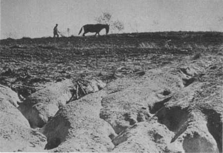
| Eroded lands which became part of the Shawnee National Forest, Illinois, 1930's. |
| <<< Previous | <<< Contents>>> | Next >>> |
region/9/history/chap6.htm
Last Updated: 28-Jan-2008