|
POSSIBILITIES OF SHELTERBELT PLANTING IN THE PLAINS REGION
|
|
Section 14.—GROUND-WATER CONDITIONS OF THE SHELTERBELT ZONE
By G. E. CONDRA, Dean, Conservation and Survey Division, and State Geologist, University of Nebraska
CONTENTS
Ground-water relations
Water-bearing horizons
Ground-water regions
North Dakota
Surface features
Areal bedrock map
Ground-water horizons
Lowering the water table
Replenishment of ground water in the bedrock formation
Spring water
Artesian wells
Ground-water regions
South Dakota
Surface features
Topographic regions
Structural conditions
Bedrock map
Ground-water horizons
Artesian water
Spring water
Ground-water regions
Nebraska
Ground-water regions
Kansas
Surface features
Structural conditions
Ground-water horizons
Ground-water regions
Oklahoma-Texas Ground-water horizons Ground-water regions
Bibliography
The amount of ground water within the shelterbelt zone, not including the soil and subsoil moisture, is far greater than that of the surface water, and considerably greater than the volume of an annual rainfall. It has important economic relations in supplying well water, subirrigation water, and springs.
In some places where the ground water is shallow, it contributes directly to the growth of plants. There are in the shelterbelt zone a number of such areas, often sandy in character, whose boundaries are shown on the accompanying water-region maps which accompany the report. A knowledge of the location of areas in which the water table lies at depths of 5 to 20 feet is invaluable, because such localities offer the best possibilities in the shelterbelt zone for tree planting, from the point of view of growth and longevity. Such localities probably occupy, altogether, some 5 or 6 percent of the total area of the zone. It is entirely reasonable to assume that in these same areas in drought years, recently established plantations could be irrigated by systems of temporary wells and portable power pumps.
Over the remainder of the area the water table is beyond the reach of tree roots, but information as to the depth, quantity, and quality of the water is of interest especially in deciding the location of forest nurseries. A plentiful source of good water at a practical depth is an important factor in influencing the cost of production of the nursery stock. The quality of the water is of prime importance because a water of high mineral content will eventually destroy the usefulness of the soil for nursery production.
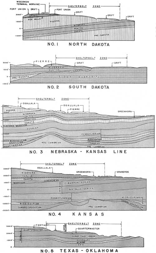
The following description of ground-water conditions in the shelterbelt zone is accompanied by areal geologic maps, geologic cross sections, and State water-region maps. The principal facts considered are the geologic occurrence of ground water, its source of replenishment, accessibility, quality, and quantity.
The data presented come from the writer's investigations and experience and from conference with the following State geologists: H. E. Simpson, North Dakota; E. P. Rothrock, South Dakota; R. C. Moore, Kansas; C. N. Gould, Oklahoma; and E. H. Sellards, Texas.
GROUND-WATER RELATIONS
The source of ground water in this area is precipitation, local and distant. Part of the run-off of rain and snowfall is trapped in porous soil, porous mantle rock, and along the out-crop areas of porous bedrock formations. The water so trapped is in slow motion by percolation downward and laterally through the contained beds from its source or sources of replenishment to places where it is lost by evaporation, transpiration, leakage, or through wells.
Some close-textured soils, as shales in the hilly lands, pass much of the rainfall at once to surface run-off, whereas the thick, open-textured, sandy formations, whether flat or rough, absorb the maximum of rainfall and pass it to ground storage, from which it later emerges through the deeper drainage ways. Certain porous bedrock formations which dip for long distances beneath impervious beds carry water under pressure (artesian).
The close relation that exists between the rainfall, ground-water intake, surface run-off, and subsurface drainage should not be overlooked. The ground water recharged from rainfall in shallow, porous formations lying upon impervious platforms in dissected areas contributes ultimately to surface run-off as streams, which, during their high stages, pass water into alluvial land storage. This reservoir of alluvial water becomes comparatively static, but its return flow to the streams during their low stages, as during dry years and drought, has a stabilizing effect on their discharge.
The sandy uplands of the shelterbelt zone absorb and store a considerable part of the rainfall as ground water, from which the subsurface drainage to the valleys and streams heading in them is comparatively uniform. Similarly, the less sandy lands having a vegetative cover of prairie or forest pass relatively large amounts of the rainfall to ground storage but with little or no underflow. Vegetative cover retards the erosion and release of sediment from the uplands. It also furthers the absorption of ground water and stabilizes the local run-off and the discharge of streams. In other words, the cover stores some water, retards the surface run-off, and passes relatively large amounts of water to ground storage, from which the movement to the surface is very slow and uniform as compared with the direct surface run-off. It may not, however, increase the total long-time run-off of an area. Only the form, stabilization, and beneficial use of this run-off are affected by such cover. In contrast to the conditions just noted, the hilly, shaly lands without a protective cover develop a minimum of ground-water storage, have little underflow to streams, and shed the rainfall as erratic surface run-off.
Geological conditions vary greatly in the shelterbelt zone (fig. 95). In places the land is deeply covered with loose mantle rock, such as alluvium, glacial drift, sand and gravel wash, loess, or dune sand. There are also large areas in the zone where bedrock of shale, chalk rock, limestone, or sandstone is at the surface and extends downward for many feet. The nature and occurrence of the geological formations influence the behavior of ground water. They also influence the mineralization of the water and the volume and condition of its storage.
Open-textured mantle rock absorbs and stores relatively large amounts of the rainfall, and its water becomes medium hard to hard. Shale and chalk rock formations carry little available ground water, and it is usually of poor quality. In contrast, the sands, gravels, and sandstone are the principal water-carrying formations of the belt, and certain persistent limestones that are porous and jointed contain hard water.
Places exist within the shelterbelt zone which are practically without ground water except at great depth, and there are other places with abundant water of good quality at various depths. This section outlines both the favorable and unfavorable ground-water conditions in the shelterbelt zone and explains them on a geologic basis.
WATER-BEARING HORIZONS
Ground-water survey is closely related to stratigraphic and areal geology. Its purpose, in the beginning, is to determine and describe the occurrences of water by geologic horizons, so as to assist in locating, developing, and improving water supplies. The leading aquifers (ground-water horizons) in the shelterbelt zone, as a whole, are as follows:
1. Alluvial bottom lands.
2. Sand and gravel deposits in, between, and otherwise associated with the till sheets (glacial deposits).
3. Sand and gravel deposits bordering drift deposits, as in central Nebraska.
4. Sand and gravel formations of Tertiary age, known as the "Ogallala and Fort Union formations."
5. Sandy layers in the Fox Hills formation (Cretaceous) of North Dakota and South Dakota.
6. The Dakota group of sandstones, which underlie extensive areas. These are at the base of the Cretaceous in North Dakota, South Dakota, Nebraska, and a considerable part of Kansas.
7. Certain Permian and Pennsylvanian sandstones and limestones in Oklahoma and Texas.
8. Various bedrock horizons too deep to be tapped for use by the shelterbelt project.
NOTE.—Except the Dakota sandstones and the sandy beds of the Laramie and Fox Hills, practically none of the Cretaceous formations in the shelterbelt zone yield ground water. These non-water-bearing formations are the Graneros Shale, Carlile shale, Niobrara chalk, and Pierre shale, all widely distributed and quite thick. At places in Nebraska and Kansas, however, the massive basal part of the Niobrara does afford some well water and springs. The Brule clay at the base of the Tertiary in small areas of the shelterbelt zone in South Dakota and Nebraska carries a little water, and large areas of the red beds of Oklahoma contain small amounts of available water.
The distribution of the water-bearing and non-water-bearing formations of the shelterbelt zone is shown by the accompanying areal geologic maps and cross sections and is explained in connection with the discussion of the water regions of the States.
GROUND-WATER REGIONS
During the past few years some attempt has been made to delimit and describe the ground-water resources by natural regions or provinces. Thus far, however, no uniform basis has been agreed upon among water geologists for the description, correlation, and naming of these regions, many of which cross State lines. Most of the ground-water regions now recognized were delimited and named from surface features of the land rather than from the geological conditions. Others were described with reference to the nature and occurrence of the water, whether scant, abundant, shallow, deep, artesian, soft, alkaline, hard, or highly mineralized, and some were named from their geographic position. It seems, therefore, that there is need for the revision of the nomenclature relating to water regions. In the following discussion the water region names now in use are recognized, but with some revision due to correlation that must be made between the States.
The ground-water conditions are now described regionally by States.
NORTH DAKOTA
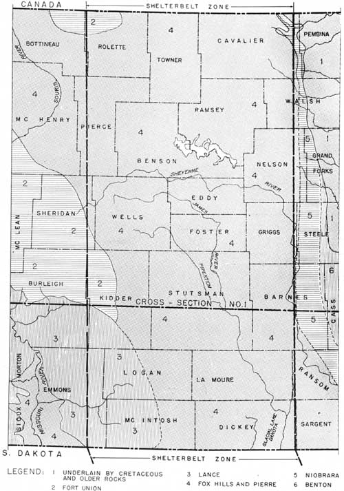
The late A. G. Leonard,51 Simpson,52 and others have described the geology and ground waters of North Dakota, and their reports have supplied most of the data herein compiled. The conditions are mapped in cross section no. 1, figure 95, and figures 96 and 97. The geologic column is described in table 24.
51In Geology and Natural Resources of North Dakota. See Bibliography at end of section.
52In Geology and Ground-water Resources of North Dakota. See Bibliography at end of section.
|
| FIGURE 95.—Typical geological cross sections of the shelterbelt zone by States. (click on image for a PDF version) |
TABLE 24.—Geologic column in the shelterbelt zone of North Dakota
| Age | Name of formation | Thickness | Lithologic character |
| Feet | |||
| Recent and Pleistocene. | Alluvium | 1-250 | Silt, sand, gravel. |
| Lake silt. | 1-100 | Silt and some sand. | |
| Do | Till and associated deposits. | 10-450 | Till; clay with sand, gravel and boulders; coarse morainic materials; outwash deposits. |
| Eocene and Tertiary. | Fort Union formation. | 1,200 but less where eroded. | Beds of light-colored clays, friable sandstones and lignite. |
| Tertiary (?) Cretaceous (?) | Lance formation | Maximum where not removed by erosion about 900. | Gray sandstone, clay, and lignite beds. |
| Cretaceous | Fox Hills formation | 125 or less | Soft massive yellow to gray sandstone. |
| Do | Pierre shale formation. | 300-1,100 | Largely dark-gray shale. |
| Do | Niobrara formation | About 270 | Light-gray shaly chalk. |
| Do | Benton shales, equivalent of Carlile, Greenhorn, and Graneros. | About 500-600 | Dark-colored shales; the Greenhorn limestone not reported. |
| Do | Dakota group | 400-500 | Friable sandstones; and shales. |
| Jurassic | Probably absent. | ||
| Triassic | Probably absent. | ||
| Paleozoic | Reached in few wells; not differentiated. | ||
SURFACE FEATURES
The following description is by Leonard:
In traveling from east to west across the State one crosses three plains rising one above another. The lowest of those is the broad Red River Valley, with an elevation of from 800 to 1,000 feet above sea level.
The remarkably level plain known as the Red River Valley stretches along the eastern border of the State and extends from 30 to 40 miles west of the river. Near the southern end, at Wahpeton, the valley has an elevation of 965 feet; at Fargo it is 905 feet; at Grand Forks, 830 feet; and at Pembina, near the Canadian line, 789 feet above sea level, the slope toward the north being only about one foot to the mile. . .
West of the Red River Valley, and lying between that and the Missouri Plateau, is a plain intermediate in elevation between the surface on either side. Since it is everywhere covered with glacial drift, it may be called the Drift Plain, though the drift-covered portion of North Dakota is not confined to this plain, and the deposits of the ice sheet are also found on the Missouri Plateau. . .
Bordering the Drift Plain on the west is an escarpment even more prominent than that forming its eastern margin. This escarpment marks the eastern edge of the Missouri Plateau, which stretches westward to the Rocky Mountains. . .
The surface features of North Dakota have been formed by various processes, but in general they have originated in one of three ways, namely, (1) through the agency of continental glaciers or ice sheets, (2) through the erosion of streams and running water, and (3) through the agency of lakes. There are thus three types or kinds of land surface within the State which differ widely in origin and are strikingly unlike in general appearance. These are the level lacustrine plains of the Red River Valley and the Mouse River region in Bottineau and McHenry counties; the wide stretching, gently rolling to rough Drift Plain with its in numerable lakes, its comparatively few rivers and imperfect drainage, occupying nearly two-thirds of the State; and the plateau area. . .
Both the Red River Valley and the Mouse River53 district are old lake plains or the bottoms of former lakes. The sediment carried into these was spread far and wide over the floor of the lakes to form the remarkably level lacustrine plains of Lake Agassiz and Lake Souris. The broad depression of the Red River Valley, which during the Glacial Period was occupied by Lake Agassiz, was eroded to a depth of 800 to 900 feel in the Cretaceous and older rocks of eastern North Dakota and adjoining parts of Minnesota by a large northward-flowing river. Later, during the Glacial Period and before the advent of Lake Agassiz, this old valley was filled to a depth of 200 to 300 feet and over with drift left by the continental ice sheet when it invaded the region. The old valley floor is thus deeply buried beneath this mantle of glacial debris, and is only reached in deep wells which have penetrated the drift and entered the underlying bedrock, the latter being in many places granite. Lake Agassiz was formed through the damming of this ancient northward-sloping valley by the ice sheet which covered the country to the north and formed a thick ice barrier to the north and northeast, while higher land held in its waters on the other sides of the basin. During the time the lake was in existence, sediment carried in by rivers was spread over the bottom to a depth of 20 to 50 feet, covering the drift in most places. . .
53The Mouse River District is the Souris River Basin.
Gravel and sand beaches were built up by the waves about the shores of Lake Agassiz, and the rivers entering the lake carried sediment which accumulated to form deltas. The best-developed beach ridges, which commonly rise 10 to 20 feet above the adjoining surface on the side toward the former lake, vary in width from 10 to 30 rods, and are composed of gravel inter-stratified with sand. The development of these beaches varies greatly from place to place, depending apparently upon the abundance and character of the materials within reach of the waves.
Three deltas were formed in that portion of the lake included within North Dakota. The largest, that of the Sheyenne River, lies mostly in Richland and Ramsey counties, covering an area of not far from 800 square miles. The sand has been heaped by the wind into dunes, and a large tract of the delta is covered by these sandhills. The Pembina River formed a delta having an average thickness of 150 feet, and Larimore is built on another such deposit which extends from McCanna south to Mayville and Portland. The stream which formed this latter delta is no longer in existence.
The surface features of the Drift Plain are due to the irregular and uneven deposition of drift, which is heaped up more in some places than in others, so that its surface is gently rolling to rough. It thus presents a marked contrast to the erosional topography of the region west of the Missouri River, and to the level areas of the lacustrine plains. The ice sheet which invaded North Dakota from a center of movement west of Hudson Bay has been by far the most important factor in moulding the surface areas of over two-thirds of the State. Even the lacustrine plains are indirectly the result of the ice invasion, since the lakes which formed them had their origin in the blocking of the drainage by the glacier. The preglacial surface had undergone great erosion during the long Tertiary period, so that it was doubtless quite uneven and rough and cut by many stream valleys, probably resembling somewhat the area west of the Missouri River as it appears today. The ice sheet modified all this and tended to level the region by wearing down the hills and ridges and filling the valleys with glacial debris. As it withdrew it left behind the heavy mantle of drift which conceals from view the preglacial surface. The drift is commonly from 150 to 300 feet thick. It is this deposit which has determined largely the surface features of the Drift Plain.
During its recession the ice sheet halted again and again and thus built a series of moraines. Some of these halts were brief and resulting moraines poorly defined; others were of much longer duration, as shown by the great amount of material deposited and the large size of the hills and ridges. By far the best developed of these morainic belts is the Altamont moraine, marking the limit reached by the Wisconsin ice sheet. * * * It stretches across the State from northwest to southeast and extends without interruption for many hundreds of miles. This remarkably well developed moraine forms a very rough belt of massive hills and ridges which in places has a width of 20 miles and over and throughout most of its extent in North Dakota probably averages at least 12 to 15 miles in width. Many of the hollows and undrained depressions which occur in such large numbers among the hills are occupied by lakes, ponds, and marshes. But while lakes are more numerous in the morainic areas they are also common elsewhere on the Drift Plain. They are in fact very characteristic of the Drift Plain as a whole, dotting the surface by the score and hundred and adding beauty and variety to the landscape. The largest is Devils Lake, which owes its existence to the partial filling with glacial drift of an old river valley and its tributaries, the unfilled portion of the valley being occupied, by the lake.
The small number of rivers is another notable feature of the Drift Plain. Besides the Missouri River, which may be considered as forming the western boundary of the drift-covered plain, the Mouse, James, and Sheyenne are the only streams of any importance, and even these have few tributaries. There are entire counties, such as Kidder, Logan, and McIntosh, which are without a single river. This scarcity of streams and abundance of lakes indicates a young land surface on which rivers have not yet had time to erode valleys and whose lakes have not been drained or filled. * * *
So recent is it geologically since the last ice sheet withdrew from North Dakota, and since Lake Agassiz and Lake Souris were drained, that the surface of the Drift Plain and the lake beds have been but slightly affected by erosion and are still much as they were left at the close of the Glacial Period.
As has already been pointed out, much of the Missouri Plateau, or that portion lying east of the river, is covered by a thick deposit of glacial drift and thus has the topography of a drift plain. * * *
AREAL BEDROCK MAP
The map (fig. 96) shows what bedrock formations lie immediately below the mantle rock, i. e., where they would appear at the surface in the shelterbelt zone if the mantling beds were removed. The Fox Hills, Pierre, and Niobrara formations outcrop at few places in the zone, and the Fort Union and Lance outcrop more prominently.
|
| FIGURE 96.—Geological bedrock map of shelterbelt zone in North Dakota. (click on image for a PDF version) |
It should be observed in this connection that the area (4) designated as Fox Hills-Pierre has been delimited largely from well logs. Undoubtedly the Pierre is the topmost bedrock formation in most of this occurrence, especially to the east and south, but without much doubt it is thinly covered by lower beds of the Fox Hills at places to the west and north, as evidenced by the logs of wells and the quality of well water obtained.
GROUND-WATER HORIZONS
Much of the ground-water supply of North Dakota is obtained by shallow wells in the mantle rock, in the alluvial, lacustrine, and drift deposits. The water-bearing horizons in the bedrock are in the Fort Union, Lance, Fox Hills, and Dakota formations. Those of the older formations lie too deep for economic production.
LOWERING THE WATER TABLE
Evidently the water table stood high in the shelterbelt zone in the mantle rock deposits when the last glacier (Wisconsin) retreated from North Dakota, but it has since lowered in the areas adjacent to the main valleys, owing to their erosion. It also has fluctuated upward and downward in response to seasonal evaporation and rainfall and to periods of wet and dry years. The retreat of the ice dam from the Red River and from the Souris River Basin caused lowering of ponded lakes in these areas, followed by a drop of the ground-water level, first in the border lands and later in the beds of the basins that had been occupied by the lakes.
The water level still stands relatively near the surface in most of the shelterbelt zone of North Dakota, approximately where it may be expected to remain in response to replenishment from rainfall, the slow depletion by underdrainage, and the poorly established surface drainage.
REPLENISHMENT OF GROUND WATER IN THE BEDROCK FORMATION
Although the mantle rock of North Dakota generally rests upon an eroded, impervious bedrock platform, there are local zones of replenishment extending into the bedrock horizons. The drift cover on the Fort Union and Lance formations loses some water by percolation and through joints to the Fort Union and Lance formations, and some of the underflow in the lower sands and gravels of the drift and alluvial deposits passes into the impervious horizons of the Fort Union, Lance, and Fox Hills formations and moves along the dip to greater depths.
The intake of the Dakota group, according to most geologists, is thought to be along the flanks of the Black Hills and other mountains to the west, yet there are some who maintain that this source of replenishment is not accountable for all the water in the Dakota sandstones, in the broad areas east of the mountains. The dissenters point to certain areas in which the replenishment is plainly local and to certain other places where it is largely from along the flanks of old high lands east of the broad Dakota basin, as the Sioux Falls "high" and the Laurentian Highlands. It seems, therefore, that the water of the Dakota sandstones in North Dakota may come in considerable part from the east side of the basin rather than from the more distant sources to the west.
SPRING WATER
The leakage of ground water from the shallow aquifers lying above the impervious beds in rock escarpments and along the deeper valleys of the shelterbelt zone develops numerous springs. Some of the springs issuing from small catchment areas are reduced during droughts, even to no discharge. Others are permanent.
ARTESIAN WELLS
According to Leonard, there are 6,000 or more artesian wells in North Dakota, and apparently most of them are in the shelterbelt zone. The artesian wells within the zone range between 100 and 1,800 feet in depth. The shallower ones, in small drift basins, have weak flows. Those tapping the Fort Union and Lance formations are 200 to 400 feet or more in depth, and those of the Fox Hills still deeper.
The water in the Dakota sandstones at first, second, or third horizons is under heavy hydrostatic pressure and gives strong flows. Its depth ranges from about 400 feet along the east border of the zone to 1,800 feet or more along the west border, where it is not economically feasible to drill wells to reach it.
According to Dr. Simpson, the hydrostatic pressure of the Dakota waters in North Dakota has been greatly reduced as a result of the number of wells that have been drilled to them and the wastage of water from such wells. The State has enacted legislation for the control of artesian wells and has assigned the duty of enforcing the terms of the act to the State Geological Survey.
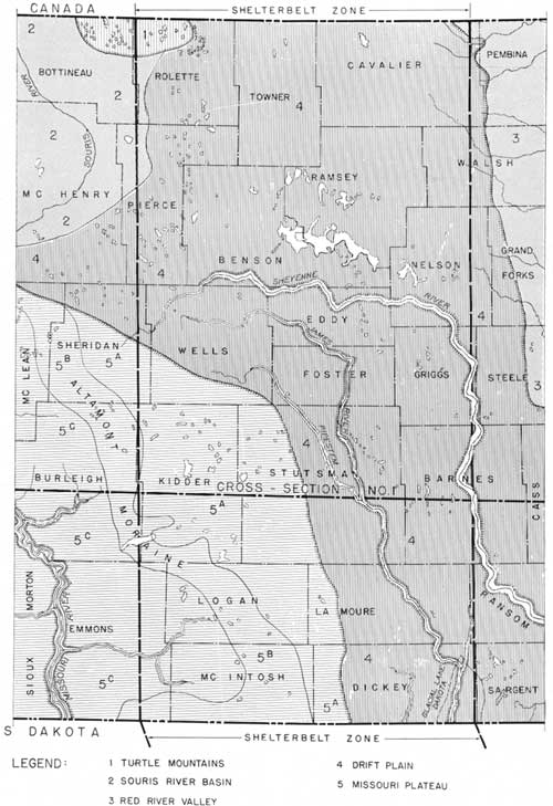
GROUND-WATER REGIONS
The ground-water regions, according to Leonard and Simpson, coincide quite closely with the topographic provinces, and are here described under the names Turtle Mountains, Souris River Basin, Red River Valley, Drift Plain, and Missouri Plateau. Their distribution in the shelterbelt zone of North Dakota is shown by figure 97.
|
| FIGURE 97.—Ground-water regions of shelterbelt zone in North Dakota. (click on image for a PDF version) |
TURTLE MOUNTAINS
The Fort Union formation caps this region. It is overlain by drift which stores the rainfall as ground water, some of which percolates into the sandy beds below and leaks out over impervious layers in the escarpment as springs, making small live streams. This region, being sparsely settled, has few wells, most of which are shallow and reach only the drift. The water is medium hard.
According to Simpson, the Turtle Mountains formerly were thickly wooded and the springs there were stronger than they have been since much of the forest was removed. If such deduction is correct, here is a good example of the relation of forest cover to ground-water storage and the indirect run-off. At any rate, this is an ideal region for reforestation and the demonstration of what changes may result from it.
SOURIS RIVER BASIN
The Souris River Basin lies to the west and southwest of the Turtle Mountains and extends only a short distance into the shelterbelt zone. Its shallow water-supply conditions are similar to those of the Red River Valley, which is described later. The deeper waters here are similar to those along the west border of the Drift Plain.
RED RIVER VALLEY
This and the following descriptions of ground water regions are quoted from Simpson (Water-Supply Paper 598):
In the Red River Valley water is obtained from shallow wells in the beach and delta deposits and in the lake silt and from deeper wells in the Wisconsin drift and the sedimentary bedrock beneath. Much of the water in the sandy layers of the drift and the bedrock is under sufficient artesian pressure to produce flows in wells of moderate depths. The lake silt supplies some shallow wells with a small amount of water, much of which is "alkaline", and the sandy beaches and deltas on the western margin yield to shallow wells some of the best water in the State. The deeper artesian waters are generally highly mineralized, especially those that come from the bedrock.
Drift Plain—In the Drift Prairie water is obtained from the alluvium in the valleys, from the glacial drift, and from the underlying rock. The drift is so thick that it is the most generally utilized formation in the State. The sand and gravel at the base of the drift, immediately above the shale, form a common source of supply.
The deposits of sand and gravel under the broad floors of the principal valleys, particularly those of the Sheyenne and the James, yield ample supplies for cities of several thousand people. The waters are commonly obtained by wells fitted with drive points and strainers. Many wells penetrate the shale that underlies the drift and draw from the few sandy layers found in it a moderate supply of slightly mineralized water.
In the southern parts of this province many wells are drilled to the Dakota sandstone and obtain strong flows of higher mineral character. The area of artesian flow of this sandstone constitutes an important subdivision of the Drift Prairie province and occupies all of its southern and central portion.
Missouri Plateau—In the glaciated part of the Missouri Plateau the water is commonly obtained from the drift, as in the Drift Prairie province. In the nonglaciated part the water is obtained from the alluvium of the valleys, the residual soils that cover the surface to considerable depths on the uplands, and the layers of lignite and sandstone in the upper part of the bedrock. In some of the larger valleys shallow wells draw an abundance of good water from the alluvial gravel and sand. These materials were largely washed out from the front of the Wisconsin ice sheet when it occupied its most advanced position along the Altamont moraine. In this region springs from the lignite and other outcropping rocks of the valley sides are so numerous that they greatly decrease the number of wells necessary. All the deeper wells enter the bedrock sandstone and lignite, and some that are located in the deeper valleys yield weak flows.
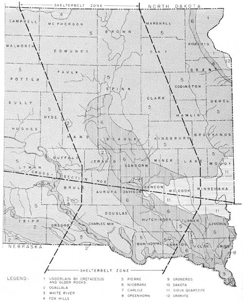
SOUTH DAKOTA
Refer to figures 98 and 99; cross section no. 2, figure 95.
|
| FIGURE 98.—Geological bedrock map of shelterbelt zone in South Dakota. (click on image for a PDF version) |
|
| FIGURE 99.—Ground-water regions of shelterbelt zone in South Dakota. (click on image for a PDF version) |
SURFACE FEATURES
The altitude of the shelterbelt zone in South Dakota ranges between 1,250 feet on the Missouri River bottom land to about 2,050 feet in the northwest part, giving a relief of about 800 feet.
Most of the belt is essentially a plain mantled with drift deposits—smooth to hilly—and trenched by the Missouri, James, and other valleys, bordering which the bedrock formations are exposed, forming rough lands. All of the belt in this State has been glaciated, much of it two or more times.
The surface drainage generally is better developed than in North Dakota but is of the same general type, with moraines, gravelly terraces, and lake basins resulting from glaciation. The glacial Lake Dakota basin (22, fig. 99) is the largest and best-defined upland plain. Some of the basins and abandoned drainage ways are occupied by lakes, most of which are intermittent.
TOPOGRAPHIC REGIONS
The topographic regions of the shelterbelt zone in South Dakota are the Missouri Plateau, which is poorly defined; the Drift Plain; the Sioux Falls area; and the Missouri River lowland.
STRUCTURAL CONDITIONS
The bedrock formations of this zone in South Dakota lie nearly level in much of their occurrence, modified by a low westward dip and by steeper inclines bordering the Sioux Falls high against which the Dakota beds thin out. The higher Cretaceous formations, if ever deposited on the Sioux Falls high, have been eroded away.
Apparently there has been some uplift of the bedrock in a northwest-southeast trend in the area northwest of the western end of the Sioux Falls high. This probably accounts for the high position of the Niobrara formation here.
The cross section (fig. 95), after Darton, passing through the Sioux Falls high and westward, shows the geological sequence of formations in that part of the shelterbelt zone. The geologic column is given in table 25.
TABLE 25.—Geologic column of the shelterbelt zone, South Dakota
| Age | Name of formation | Thickness | Lithologic character |
| Feet | |||
| Recent and Pleistocene. | Alluvium | 0-100 | Silt, sand, gravel. |
| Loess | 0-20 | Largely silt. | |
| Drift deposits | 0-300 | Till, silt, sand, gravel, boulders. | |
| Pliocene | Ogallala | 0-100 | Sandstone, silt, sand, gravel. |
| Cretaceous | Fox Hills | 40 | Shale, sandstone, coal seams. |
| Pierre | 0-700 | Dark-gray shale. | |
| Niobrara | 200-250 | Shaly chalk above; sandy lime or limy sandstone at base. | |
| Carlile | 1 200 | Dark shale, some sandstone. | |
| Greenhorn | 24 | Thin limestone and shales; thins out northeastward. | |
| Dakota group | 0-400 | Sandstones and shales, some coal. | |
| Marked unconformity on older formations. | |||
| Paleozoic | Probably under portions of zone. | ||
| Pre-Cambrian | Sioux | 0-500 | Quartzite and sandstone. |
1About. | |||
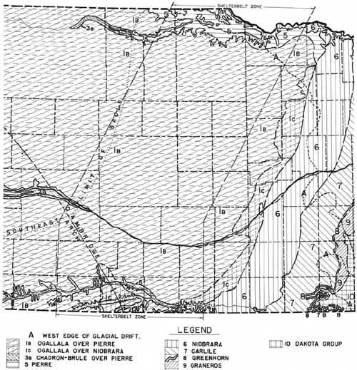
BEDROCK MAP
Figure 98 shows where and what bedrock formations would appear at the surface in the shelterbelt zone of South Dakota, if the drift, lacustrine, and alluvial deposits were removed. Data used in the compilation of this map were obtained from the South Dakota Geological Survey, Todd's Bulletin 158, United States Geological Survey, Darton's Water Supply Paper 227, United States Geological Survey, Geologic Atlases 96, 99, 100, United States Geological Survey, and other sources. The map also shows the distribution of the bedrock formations in areas adjacent to the shelterbelt zone.
GROUND-WATER HORIZONS
Ground-water horizons are in (1) the alluvium, (2) drift and associated deposits, (3) Ogallala formation, (4) Fox Hills formation, (5) Niobrara formation, basal portion, (6) Greenhorn limestone, (7) Dakota sandstones, (8) Sioux formation (quartzite).
The water-supply reports on South Dakota refer to ground-water horizons at the top and near the base of the Carlile. This study of the water horizons in northern Nebraska, however, shows quite conclusively that the Fort Hayes base of the Niobrara there is quite sandy and an aquifer of some importance, and also that the Greenhorn produces water in some wells. It seems, therefore, that these horizons may persist to and through the South Dakota section, and that they may be correlative with the upper and lower Carlile horizons of Darton and others.
ARTESIAN WATER
Water under pressure. occurs immediately beneath the drift deposits, in small areas; in the sandy basal member of the Niobrara, more generally; in the Greenhorn at some points; and in the Dakota throughout the zone, except at upper parts of the Sioux Falls high. The flowing wells in the drift are shallow, yielding medium-hard water. Those reaching the basal Niobrara and the Greenhorn are considerably deeper, yielding soft to medium-hard water. The Dakota wells range from about 250 to 1,000 feet in depth, and their water is quite highly mineralized but usually potable.
SPRING WATER
The springs in the shelterbelt zone of South Dakota are numerous, but most of them are affected by heavy rainfalls and drought. They occur largely on the sides of valleys, where water is released from the drift deposits along the contact with impervious shales, and at the borders of the tableland outliers.
GROUND-WATER REGIONS
The six ground-water regions in the shelterbelt zone of South Dakota are the poorly defined Missouri Plateau, the Drift Plain, the Sioux Falls region, the Pierre-Niobrara region, the tableland region, and the Missouri River lowland region (fig. 99).
MISSOURI PLATEAU
The Missouri Plateau, as noted above, is well shown at places in North Dakota, but its occurrence in South Dakota is limited and poorly defined, i. e., not well set off from the Drift Plain. Evidently, however, there is a small area of the Fox Hills in the northwestern part of the shelterbelt zone in this State. It is mantled generally with drift, from which water percolates to the sands below. The water in the drift is drawn upon through shallow wells, and the deeper water of the Fox Hills is tapped by a few deeper wells which produce hard or alkaline water (not very desirable for drinking).
The region is underlain by the Pierre shale and the regular succession of Cretaceous formations down to and including the Dakota which is quite deep.
DRIFT PLAIN
The drift plain presents about the same features here as in North Dakota, but has been trenched more by rivers, with resulting greater leakage from the shallow waters. Its broad interstream areas are modified by moraines and depressional areas, of which the fossil Lake Dakota basin is the largest. There are also extensive alluvial lands in the James Valley and its tributaries and in certain interglacial valleys that are filled or nearly filled with coarse sediments.
The writer is in doubt regarding just what glaciations and deglaciations were enacted here. Todd54 maps the Altamont and other moraines of this belt and seems to infer that the narrow strip of drift south of his Altamont moraine may be the Kansan. Then, in an area not far east of this belt, Leverett and Sardeson55 map the Altamont moraine, also the Wisconsin, Iowan, and Kansan drifts. Their Altamont moraine seems to correlate with the Altamont of Todd.
54In The Moraines of Southeastern South Dakota and Their Attendant Deposits; see Bibliography at end of section.
55In Quaternary Geology of Minnesota and Parts of Adjacent states; see Bibliography at end of section.
A personal study of the drift sheets in Nebraska just south of the shelterbelt zone of South Dakota has shown that both the Nebraskan and Kansan tills occur there, the first named being the thicker and separated from the latter by sands and gravels of Aftonian age. It seems, therefore, that both the Nebraskan and Kansan ice sheets must have advanced over at least part of the shelterbelt zone in South Dakota, and that their tills probably were deposited there and should be found there now unless they have been removed by erosion.
The Kansan till sheet is high in the uplands in the eastern part of the shelterbelt zone of Nebraska, where it has been eroded through locally and entirely removed in places. This means that if erosion has been as active north of the river, all the Kansan till may have been eroded away there and its former western border effaced eastward beyond the shelterbelt zone. In this event, the Nebraskan may be Todd's old drift located just south of the Altamont moraine in the shelterbelt of South Dakota, and it may or may not be the Kansan in the area mapped by Leverett and Sardeson. At any rate, the Nebraskan invasion probably crossed South Dakota as far westward as west of Yankton.
Finally, although it is generally supposed that all the drift back of the Altamont moraine, as mapped by Todd, is the Wisconsin, it is believed that the Kansan or the Nebraskan or both of these, and probably the Iowan, may occur beneath the Wisconsin at places in that area. The occurrence, age, and correlation of the drift deposits in this part of South Dakota will require close study in all of the area between Iowa. Minnesota, and Montana. Such an investigation, if made, should be of the kind that has been made the past few years by Leverett and Sardeson in Minnesota and southeastern South Dakota, by Kay in Iowa, and by Alden in northeastern Montana.
Unfortunately the drift deposits in the shelterbelt zone of South Dakota and North Dakota are too little known to give the necessary guidance in ground-water investigation, but it can be said that the drift mantle in these States is quite thick, that it consists of several forms of accumulation and types of sediment, and that it occurs generally except where it has been removed by erosion.
The drift is the principal water horizon in the Drift Plain region of South Dakota. Its wells are driven, dug, bored, or drilled. There are also many deeper wells in this section, reaching the base of the Niobrara, the Greenhorn, or, more generally, the Dakota.
The depth of the Dakota sandstone wells increases with distance from the flanks of the Sioux Falls high, and also westward and northwestward across the region. Thousands of artesian wells have been drilled here.
There are a few disconnected areas of tablelands in the western part of the Drift Plain region, as at the Bijou Hills, where they are capped by firm Ogallala sandstone and underlain by silt, sand, and some gravel. Their ground water is of good quality.
SIOUX FALLS HIGH
There are some outcrops of the Sioux quartzite in this region, hence the name. The surface of the region is further modified by deposits of drift and alluvium. The water supply is drawn from the mantle rock deposits and also from the Sioux quartzite at depths of 150 to 300 feet. Water in this hard bedrock occurs principally in fissures and cracks, and at places in the voids of the rock, The water is of good quality.
PIERRE-NIOBRARA REGION
The Pierre-Niobrara part of the shelterbelt zone of South Dakota and Nebraska consists of bluffs, hills, and small plains developed on the Pierre and Niobrara formations. It is broken into disconnected areas or subregions which collectively are the southeastward extensions of the large Pierre Plains region lying west of the shelterbelt zone in South Dakota. The occurrence of this general region in South Dakota is shown by 51 and 52 in figure 99. The ground-water conditions in it are described under the heading of Nebraska.
TABLELAND REGION
Along the west border of the shelterbelt zone at the boundary between South Dakota and Nebraska are tablelands in which the ground water is of better quality than that found in the Missouri Plateau in the northern part of South Dakota. It occurs in the sands and gravels of the Ogallala formation, small outliers of which are found in the Bijou Hills and similar elevations east of the Missouri. The ground water conditions in the areas capped by the Ogallala in the shelterbelt zone of South Dakota and Nebraska are further discussed under the Nebraska heading.
MISSOURI RIVER LOWLAND
The Missouri River lowland lies along the Nebraska-South Dakota line. It is comparatively narrow here, but much broader farther east. The ground water here occurs in the deep alluvial lands along the river and in the bedrock horizons. There are a number of flowing wells in this part of the region, some of which are allowed to waste the water. The alluvial water, though potable, is not very desirable for drinking, and that of the Dakota sandstones is quite heavily mineralized.
NEBRASKA
Refer to figures 100 to 103; cross section no. 3, figure 95.
|
| FIGURE 100.—Geological bedrock map of shelterbelt zone in Nebraska. (click on image for a PDF version) |
|
| FIGURE 101.—Ground-water regions of sheltebelt zone in Nebraska. (click on image for a PDF version) |
|
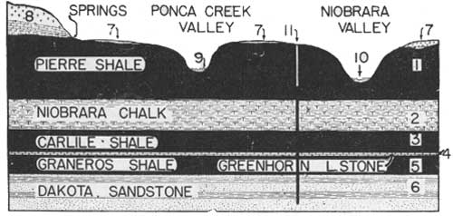
| FIGURE 102.—Cross section of eastern Boyd County and the Niobrara valley, showing the geological formations and the water horizons. The region is underlain by the Pierre shale and other shaly and chalky formations, and quite deeply by the Dakota sandstone. There is no available water in the shales and chalk. The areas where the shale is at the surface carry little or no well water. The sandy, silty surface formations to the north (8) absorb considerable rainfall and store it above the impervious shale. This condition affords well water and springs. The thin surface sand (7) stores small amounts of rainfall from which limited water supplies are obtained during wet years, but the water is depleted by underdrainage, evaporation, and use during dry years. The run-off from the uplands stores water in the alluvial bottom lands (9 and 10), which are the most dependable sources of well water, except where the alluvium is thin and its water is not recharged during drought. However, the Niobrara alluvium is supplied quite uniformly by water coming from the sand hills. The last resort in obtaining water on the shaly land of the area represented by this cross section, and at similar points farther east, is to make deep wells to the Dakota sandstone, from which, owing to artesian pressure, the water is lifted near the surface, as shown by the well at (11). |
|
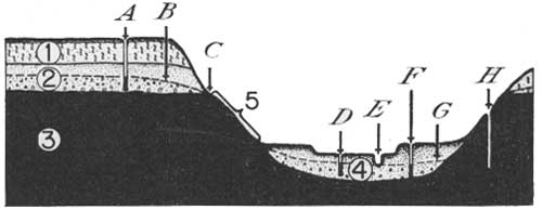
| FIGURE 103,—Cross section of the Republican valley in Webster County. Note the dry, shaly land belts along the valley sides (5) on shale (3). Observe the location of the thick, upland sands and gravels (2) in which there is a strong underflow from the Platte valley with the water table at B. There is water-bearing alluvial land in the Republican valley (4). The dependable water supplies here during drought are obtained from the underflow along the Republican and from the sands that are recharged from the Platte valley. Elsewhere in the area of the cross section there is little water except that found in the Dakota sandstone at a depth of 400 feet or more on the valley floor and at greater depths in the uplands. The location of the river is at E; a bottom-land well is at D and a terrace well at F, whereas a dry well is in the shaly land at H. The water-table level is shown by G. |
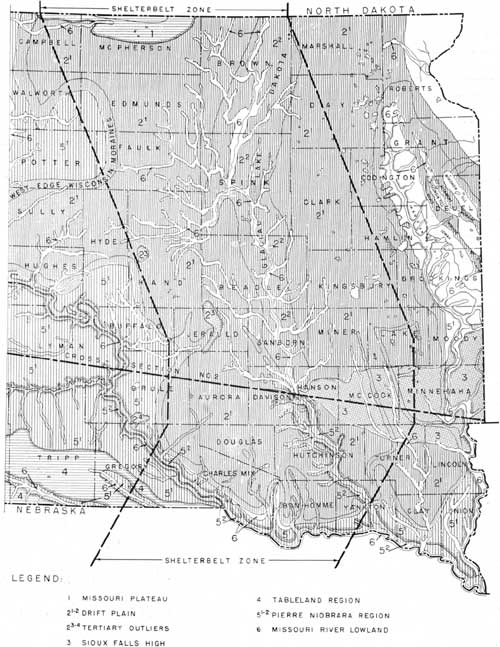
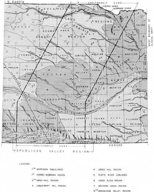
Of the 14 ground-water regions in Nebraska, 9 extend into the shelterbelt zone and are known by topographic names as follows: Missouri River Lowlands, Northern Tablelands, Pierre-Niobrara region, Sand-hill region, Loess-Drift Hills, Loess Hills, Platte River Lowland, Loess Plain, and the Republican Valley region. Physiographically the Northern Tablelands are comparable to the Turtle Mountains and the Missouri Plateau. The Missouri Lowlands are common to South Dakota, Iowa, Nebraska, and some other States. The Pierre-Niobrara region is best developed west of the shelterbelt zone and is quite well shown in Nebraska; the Loess-Drift Hills region is a continuation of the Drift Plain of the Dakotas, but in Nebraska it is more eroded and is capped with two loess formations.
Except in two regions, the shelterbelt zone in Nebraska is deeply mantled with alluvium, dune sand, loess, or thick sheets of fluvio-glacial sands and gravels, and, in a small area, by glacial drift. Parts of it are underlain at or near the surface by loosely consolidated Tertiary deposits.
The impervious bedrock platform on which the water-bearing mantle-rock formations rest is largely shales and chalk rock, and the zone is underlain at a greater depth by the well-known sandstones of the Dakota group, in which the artesian-water pressure is sufficient to cause a flow in wells located along certain bottom lands. There are places on the slope lands bordering the valleys in the Pierre-Niobrara region and the Republican Valley region where the impervious bedrock is exposed and where there is little or no ground-water storage. Aside from these places, there is an abundance of ground water in the zone, usually of good quality. The geologic column is given in table 26.
TABLE 26.—Geologic column in the shelterbelt zone of Nebraska
| Age | Name of formation | Thickness | Lithologic character |
| Feet | |||
| Recent and Pleistocene. | Alluvium | 0-90 | Silt, clay, dust, sand, and gravel. |
| Dune sand | 0-150 | Dune sand and wind-blown dust, silt, and clay. | |
| Peorian loess | 0-200 | ||
| Loveland loess: | |||
| Loess phase | 0-135 | Red eolian silt, clay, and fine sand. | |
| Valley phase | 0-35 | Red sand and silt, some fine gravel. | |
| Upland formation | 0-35 | Greenish-gray silt and clay—gumbotil. | |
| Kansan gumbotil | 0-3 | ||
| Grand Island sand and gravel | 40-100 | Sand and gravel; boulder clay. | |
| Kansan till | 0-100 | ||
| Fullerton formation | 20-85 | Silt and clay (Fullerton); sand and gravel, and gumbotil. | |
| Intertill sand and gravel | 0-50 | ||
| Nebraskan gumbotil | 0-6 | ||
| Holdrege formation: | 50-100 | ||
| Nebraskan till | 0-100 | Sand and gravel; boulder clay. | |
| David City formation. | 30 | Sand and gravel. | |
| Erosional unconformity on bedrock formations. | |||
| Pliocene | Ogallala | 0-127 | Sand, sandstone, gravel, and clay. |
| Cretaceous | Pierre shale | 0-700 | Dark-gray shale, some bentonite seams. |
| Niobrara chalk | 280-510 | Gray chalk; sandy lime at base. | |
| Carlile shale | 155-280 | Dark shale, concretions. | |
| Greenhorn limestone | 25-40 | Thin limes and shales. | |
| Graneros shale | 80-90 | Dark shale, sandy at base. | |
| Dakota group | 400-600 | Sandstone, shales; thin coals. | |
Pre-Cretaceous (many formations, but not tapped for water in shelterbelt zone in Nebraska). | |||
GROUND-WATER REGIONS
A review of the ground-water conditions of the various regions of the shelterbelt zone in Nebraska follows. The numbered locations refer to figure 101.
NORTHERN TABLELANDS (11-14)
These are the high uplands principally in Boyd and Holt Counties, and as noted before, they extend into South Dakota (subregion 5). They are erosional remnants of a former large tableland, formed on the Ogalalla beds of Tertiary age, which rest upon Brule clay to the west and upon the Pierre shale to the east. Much of the rainfall here passes to ground-water storage, from which springs issue along the deeper drainage ways at the contact with the impervious bedrock platform.
The wells of this general region range between 75 and 100 feet or more in depth. Their water is medium hard and potable. The only weak wells are those located near the edge of the tablelands adjacent to the shaly lands, where little water remains in storage, owing to leakage.
PIERRE-NIOBRARA REGION (15)
The Pierre-Niobrara region occupies central Boyd County and narrow belts along the Keyapaha, Niobrara, and Missouri Valleys. It is a continuation southward of subregion 41 and 42 of South Dakota. The surface—flat, rolling, hilly, or rough—was largely developed on the Pierre shale and Niobrara chalk. Direct surface run-off is relatively high, except from small areas of sandy land along the valleys and small, scattered tracts on the uplands.
Much of this region is not well supplied with shallow ground water and suffers from drought. Use is made of the springs issuing from the tablelands bordering the region. Shallow wells tap the storage in alluvial and other sandy areas. The creeks and rivers are sources of supply. Surface run-off is ponded at many places, mainly for stock water. The last recourse for a ground-water supply is the Dakota sandstone, at depths varying from about 400 feet on the Missouri River bottom land at the east border of the zone to 1,000 feet or more on the uplands westward. Several artesian wells have been drilled in the Missouri and Ponca Creek Valleys, and deeper wells in which there is no flow have been drilled on the upland.
The water from the Dakota is potable but considerably mineralized. That from the local areas of sandy land is suited for drinking purposes.
SANDHILL REGION (21-24)
The sand hills of the shelterbelt area were formed by wind, principally of materials from the fluvio-glacial and Ogallala formations. They mantle to various depths the lower zones of the formations from which they were derived and are deeply underlain by impervious beds. Since they are open-textured, most of the rainfall becomes ground water, with underflow to the Niobrara, Elkhorn, Loup, and other rivers. The water table is high, being exposed in the basins and valleys as marshes and lakes. In places where the water table is at or near the surface, it is lowered by evaporation, transpiration, and natural and artificial drainage. It is elevated by underflow from the extensive storage grounds, and by local rainfalls.
There is a vast amount of water in the sand hill region, usually of good quality and soft to medium-hard. Its mineralization runs 60 to 100 parts per million. Some of the lakes and lake basins are heavily alkalinized, but deeper beneath them is good potable water. Well water can generally be obtained at shallow depths in the region, most wells being driven. Windmills are largely used for pumping.
The drought of the past few years did not cause much lowering of the water table in this region, although there was a drop of 2 to 4 feet in some valleys, causing many of the lakes to lower and disappear. The rivers that head in the sand hills showed no marked reduction in discharge, but their discharges were reduced somewhat in their courses outside the region, owing mainly to excessive evaporation and to transpiration.
The prairie-plains (22) subregion of the sand hills is a nearly flat prairie land, dotted with few sand hills proper. Much of its soil is sandy, and the water table is shallow. This area, like the hay flats in the sand hills proper, is favorable for forestation.
The sand hills constitute Nebraska's most important water-storage ground. The main ground-water problems here relate to the regulation of artificial drainage, and the prevention of the wastage of artesian water. There are many flowing wells in the shelterbelt zone of the sand hill region with depths of 80 feet or more. They tap horizons in the Pleistocene and Tertiary formations.
LOESS-DRIFT HILL REGION (3)
The Loess-Drift Hill region occupies much of northeastern Nebraska, extending a short distance into the shelterbelt zone, in Knox County. The region is characterized by the presence of two sheets of glacial drift, known as the Nebraskan (lower) and the Kansan (upper). They are composed of till, some sand, and boulders. They carry only small quantities of available water, but are separated at many points by the Aftonian sands and gravels, which supply well water at places where the storage is not lost through drainage to the valleys. Locally, there are irregular and often discontinuous deposits of sand and gravel below the Nebraskan drift. This horizon also affords some well water in parts of the region.
In the shelterbelt zone the sands and gravels next below the Nebraskan drift are irregular in occurrence; the Nebraskan sheet is well defined; the Aftonian is quite thick, and the Kansan has been largely eroded, becoming thin to the west. Water occurs in the Aftonian where drainage and drought have not depleted it, and some water is found in the subglacial sands and gravels, which rest upon the eroded Cretaceous formations.
In places where sufficient water is not found in the sands associated with the drift sheets, wells are located on alluvial lands, if possible. Where there are no alluvial lands and the sands mentioned above are dry or absent, deep wells are sunk to the Dakota beds, at depths ranging between 400 feet and about 800 feet, the depth increasing with surface elevation westward and with the dip of the Dakota in that direction. It should be noted in this connection that the Niobrara formation in this distribution contains some potable water in its basal member, which is known as the "Fort Hayes limestone", and that several wells tap this horizon, making it unnecessary to drill through the Carlile, Greenhorn, and Graneros formations to the Dakota beds.
The water in the alluvial and glacial sands is medium hard, and that of the Dakota in this part of the Loess-Drift region is not too highly mineralized for drinking.
LOESS HILL REGION (4)
The surface of the Loess Hill region is occupied by hills and small upland plains developed on the Ogallala formation, Pleistocene sands, and the Peorian and Loveland loesses. It is trenched from northwest to southeast by the Elkhorn Valley and branches of the Loup River and is further modified by numerous small drainage ways tributary to the major valleys. The loess mantle is thick and not very pervious. It rests upon fluvio-glacial formations (Grand Island and Holdrege) in much of that part of the region which lies in the shelterbelt zone, and upon the Ogallala formation at the west border of the zone. The large valleys are intrenched through the loess deposits and for some distance into the Pleistocene and Tertiary formations, which rest uncomformably upon the impervious Cretaceous floor.
Much of the rainfall of this region becomes direct run-off because of the deep, close-textured mantle rock. This condition causes soil erosion and gullying. Some of the run-off is absorbed by the sandy lands of the valley floors. Generally, however, the ground water of this region is replenished directly by underflow and indirectly by surface discharge coming from the sand-hill region. The direction of underflow is for the most part southeastward through Pleistocene and Ogallala deposits. Its movement is differential, being greatest in old buried channels.
The water table in the uplands is quite deep and not directly affected by drought. In the bottom lands, where the water table is shallow, there is some response to drought. The loss of water by evaporation and transpiration causes the discharge of these rivers to dwindle to some extent during summer.
The thickness of the water-filled zone above the impervious floor in this region varies from about 50 feet to more than 250 feet, averaging 125 feet or more. The ground water is medium hard and uniformly of good quality. Tubular wells are installed on the uplands and at places in the lowlands, where driven wells are common. Windmills are used generally.
PLATTE RIVER LOWLANDS (5)
The well-defined Platte River lowlands consist of first bottoms, terraces, and colluvial slopes. Water storage is in recent alluvium, the Grand Island and Holdrege formations, and the Ogallala formation, all underlain by an impervium platform of Brule clay to the west and Pierre shale and Niobrara chalk farther east. There is a vast storage in this region, in sands and gravels extending from near the surface to depths of 80 to 290 feet.
Much of the ground water of the middle course of the Platte Valley within the shelterbelt zone is in the Grand Island and Holdrege sands and at places in the Ogallala formation. It is replenished from rainfall and in part by underflow from the regions northwest, and also by the return flow and normal discharge of the North Platte and South Platte Valleys.
Much well water is used in the middle course of the Platte Valley for irrigation. This use of water tends to lower the water table at places during the irrigation season. Elsewhere, and generally in the region, the water level is lowered somewhat by plant growth and evaporation. Some water is lost by underflow southeastward to and through the Loess Plain region. Apparently, as shown by observations at many wells, the water table in the Platte Valley was lowered only a few feet during the recent drought. So long as there is rainfall and the other sources of replenishment continue in season, the water-bearing beds of this region may be expected to recharge as in the past. Much of the region is well suited to forest growing, as evidenced by results that have been obtained. Trees seem to grow best on the sandy soils where the water table fluctuates least and is not too deep.
LOESS PLAIN REGION (6)
The Loess Plain region extends about half-way across the shelterbelt zone, entering from the east. It is a flat upland thickly mantled with loess deposits and underlain by the Grand Island and Holdrege sands and gravels in a thickness of 100 to 200 feet. The latter deposits rest upon the Ogallala formation to the west and upon the Pierre and Niobrara farther east. The Holdrege and Grand Island formations are important aquifers. They carry underflow southeastward to the Republican and Blue Rivers.
Except in a few small sandy areas, the ground water replenishment from rainfall is comparatively small. The marked feature here is the underflow from the Platte Valley to the Big Blue, Little Blue, and Republican Valleys. This insures a dependable well-water supply in this belt at a depth of 125 feet or more. The wells here are of the tubular type and, except in lifting water for towns, windmills are used generally. The water is medium hard and of good quality.
WESTERN LOESS REGION (7)
The ground-water conditions in the Western Loess region are similar to those of the Loess Hill region, except that the Holdrege and Grand Island sands are absent at most points, and the storage is largely in the Ogallala formation. The surface of the region is developed on the Peorian and Loveland loesses and, locally, on the Ogallala formation. It is composed of small plains cut by numerous canyons. The main streams are permanent, owing to the water they receive from the sand-hill areas to the north and northwest.
The underflow in this region is southeastward in the Ogallala sands and gravels, which rest upon the uneven surface of the Pierre shale and, locally, upon the Niobrara, as along the Cambridge Arch. Except in the valleys, the wells are 100 feet to 300 feet in depth and are tubular. Windmills are used generally. Strong wells prevail, and the water is soft to medium hard and of good quality.
REPUBLICAN VALLEY REGION (8)
The ground-water conditions of the Republican Valley region are complicated. The Republican River and its tributaries have eroded through the upland water-bearing formations and into the Pierre shale and Niobrara chalk, exposing them in the valley sides. This condition causes the leakage of ground water from the aquifers of the uplands to the alluvial bottom lands, as in the Pierre-Niobrara region. There is practically no water in the Pierre slopes of this region and very little surface water where the Niobrara outcrops. The areas on these formations are dry zones. The Pleistocene sands are thin in parts of the region, especially south of the Republican, where underdrainage is great and the wells go dry during drought, whereas north of the valley, where there is underflow from the Loess Plain, the well-water supply is not affected much by drought. Farther west in the Republican Valley region, that is, on divides between the tributaries south of the river, there are narrow belts of water storage in the Ogallala formation at points back from the valley sides. The alluvial land along the Republican River is not very thick, but it usually carries water up to the level of the river, which lowered to a dry bed during the late drought. Locally, where there is most intake from the north, the alluvial water level in the Republican Valley held to near the normal stage.
Fortunately, the Republican Valley region is traversed by a river which is fed by small live streams, as Buffalo Creek, Rock Creek, Frenchman River, Red Willow Creek, and Medicine Creek, all of which head in sandy land, and by certain creeks farther east which head in the underflow from the Platte. Without the influence of these sandy upland aquifers the alluvial recharge would not be very dependable during drought. Fortunately, also, regions 6 and 7 drain ground water to this region as spring-fed streams, which develop storage in the alluvial bottom lands. Figure 102 shows the water conditions along the Republican Valley east of the shelterbelt zone.
Unfortunately the Dakota sands are quite deep in much of the Republican Valley region, the depth ranging from about 400 feet on the east to 2,000 feet or more at the Colorado line. The water of the Dakota here, though potable at some places, is too heavily mineralized with soda and salt at others for domestic use. A well drilled at Beaver City in 1934 reached the Dakota water at a depth of about 1,100 feet. This water is used for the municipal supply.
KANSAS
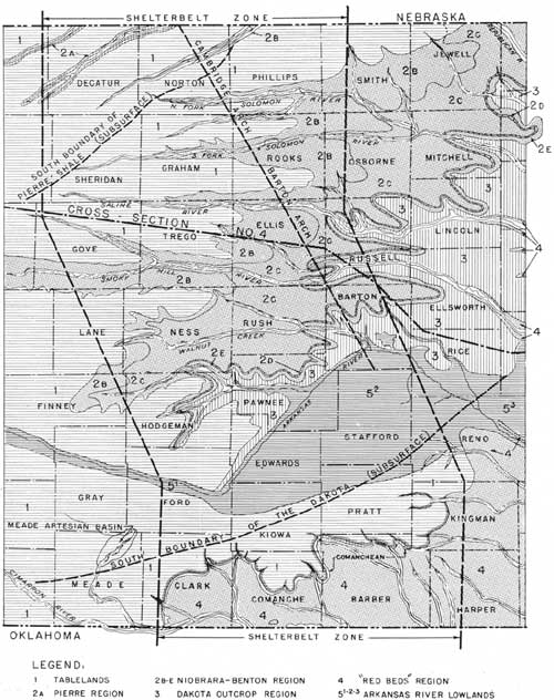
Refer to figure 104, and cross section no. 4, figure 95.
|
| FIGURE 104.—Ground-water regions of shelterbelt zone in Kansas. (click on image for a PDF version) |
The ground-water conditions in the shelterbelt zone of Kansas are quite unlike those that prevail in Nebraska. Except in the Arkansas River lowland, there is much less mantle rock storage than in Nebraska, and relatively more wells are drilled to the bedrock horizons.
SURFACE FEATURES
The surface of the zone in Kansas consists of upland plains separated by low northeast-southwest-trending escarpments and cut across by river valleys leading eastward. Traversing the belt from Barber County northwestward (fig. 104) one finds in succession the escarpment (1) at the north border of the Cimarron "Red Beds", the smooth to rolling Arkansas River lowlands (52), a belt of Dakota sandstone hills (3), a narrow, steep slope on the Graneros shale (2E), which is capped by the Greenhorn limestone (2D), a wide rolling to hilly plain on the Carlile (2C), an escarpment and a plain on the Niobrara (2B), an escarpment on the outcrop of the Ogallala, and a tableland on the Ogallala (1) thinly mantled with loess, The belted occurrence of the surface features of the land is clearly shown.
STRUCTURAL CONDITIONS
The subsurface outlines in figure 104 and table 27 show formations that persist with uniform thickness. These formations lie in regular sequence with a low dip westward and northwestward, modified by minor faulting and some folding in the area designated as the Canibridge or Barton Arch, which includes several small anticlines.
TABLE 27.—Geologic column in the shelterbelt zone of Kansas
| Age | Name of formation | Thickness | Lithologic character |
| Feet | |||
| Recent and Pleistocene. | Alluvium | 0-60 | Silt, sand, gravel. |
| Dune sand (very local) | 0-50 | Fine sand. | |
| Peorian loess (northwest). | 0-30 | Largely silt. | |
| Loveland loess (northwest). | 0-10 | Silt, clay, fine sand. | |
| Grand Island and Holdrege formations (locally at north end of zone). | 0-30 | Sand and gravel. | |
| Pliocene | Ogallala formation | 0-80 | Sand, limy sandstone, gravel. |
| Cretaceous | Pierre shale (thickens westward). | 0-200 | Dark-gray shale. |
| Niobrara (thickens westward). | 400-530 | Shaly chalk; massive sandy lime at base. | |
| Carlile | 190 | Dark shales. | |
| Greenhorn | 30-45 | Thin limes and shales. | |
| Graneros (thickens northward). | 80 | Dark shale, sandy at base. | |
| Dakota group | 300-450 | Sandstones and shales. | |
| (?) Probably correlative with basal Dakota. | Comanche | 150 | Largely shale; Cheyenne sandstone at base. |
| Unconformity | |||
| Cimarron Permian | Several formations | 800-900 | Red shales, sandstones, gypsum. |
| Big Blue Permian | Various formations | 1,000 | Not drilled for water in shelterbelt zone. |
There are unconformities at different horizons in the geologic section, notably at the base of the Cretaceous and lower. The variable thickness of the Dakota is due to the uneven floor upon which it was deposited and to the amount of erosion it has endured on its outcrop.
It should be recognized here that the Cretaceous formations rest one upon another in regular succession westward, each having little variation in thickness throughout the shelterbelt zone. This means that the Niobrara at 2B is underlain in order by the Carlile, Greenhorn, Graneros, and Dakota, and that this succession holds throughout the zone. Similarly, a well drilled on 2C would pass through such thickness of the Carlile as has not been eroded and would penetrate the Greenhorn, Graneros, Dakota, and the yet older beds in the order and thickness in which they occur. This brief statement shows how geologists are able to determine the depth to a bedrock water horizon in an area where the beds are uniform in sequence and thickness.
GROUND-WATER HORIZONS
The ground-water horizons of Kansas, named downward in order of their age, are (1) the alluvium, (2) Pleistocene sands, (3) Ogallala, (4) Fort Hayes limestone at the base of the Niobrara, (5) Greenhorn limestone, (6) Dakota sandstones, (7) sandstones at the base of the Comanche, (8) sandstones in the Permian "Red Beds." In much of the shelterbelt zone no water is tapped below the Dakota.
The basal Niobrara and the Greenhorn yield water in few wells but are sources of some spring water in their outcrop areas. The alluvial and Tertiary waters generally are medium hard to hard and desirable for drinking; locally the shallow, alluvial water is alkaline or saline; that obtained from the Niobrara carries lime and some magnesium sulphate, but is usable; the Dakota water coming from a thin sandstone above a mottled shale is saline, but elsewhere in this group of sandstones the volume of water is large and the quality is not so objectionable. The three formations carrying the most dependable water in the zone are the alluvial lands, the Ogallala, and the Dakota. The shaly lands have little and it is of poor quality.
GROUND-WATER REGIONS
As indicated in figure 104 the ground-water regions are the tablelands (1), Niobrara-Benton region (2B, 2C, 2D, 2E), Dakota Outcrop region (3),"Red Beds" region (4), and the Arkansas River Lowlands (51, 52 53). These regions have been delimited with reference to the quality, quantity, accessibility, and condition of occurrence of their ground-water supplies.
TABLELAND REGION (1)
Here, as in the northern tableland region of Nebraska, the Ogallala formation rests upon an impervious floor. It overlaps in succession, from northwest to southeast, the Pierre, Niobrara, Carlile, Greenhorn, Graneros, Dakota, and Comanche formations. The rainfall builds up storage in its open-textured zones and establishes a water level sloping eastward and southeastward and, locally, to the valleys that have been eroded to the Cretaceous rocks. The wells are largely of the tubular type, and the water supply at most places is adequate for farms and towns.
The valleys shown by 2A and 2B are tributaries of the Republican. Like most other tributaries in the Republican Valley region, they have dry zones along their borders. The Pierre shale underlies the valleys at 2A, and the Niobrara the valleys at 2B. Water from the alluvial horizons is sought at these places.
Some groves on the smooth tablelands of this region are in fair condition, but others have failed, owing in part to lack of protection. There are small, scattered areas of brush growth and trees on the rough escarpment lands.
NIOBRARA-BENTON REGION (2B, 2C, 2D, 2E)
Much of the surface of the Niobrara-Benton region is occupied by the Niobrara and Benton formations, which carry little potable water. The surface-water supply generally is inadequate except in the better developed alluvial lands and in the Dakota sandstones, which lie at a depth ranging from 125 feet or more along the eastern border of the region to a maximum of about 800 feet northwestward. Fortunately there is sufficient pressure in the Dakota horizons to force the water upward to considerable heights in the wells. The deep wells here are of the cased type.
As noted before, some wells in this region draw up on the Fort Hayes and Greenhorn horizons, but in places where these fail and there is no alluvial supply, it is necessary to drill to the Dakota or to pond the surface run-off.
Except on the outcrops of the Fort Hayes and Greenhorn limestone, on the slope land of the Graneros, and on the alluvial valley floors, there is little natural growth of brush or trees in this region. The percentage of survival of trees planted on the smoother upland formed on the Carlile and Niobrara formations has been low.
DAKOTA OUTCROP REGION (3)
The Dakota beds crop out in large areas east of and across the shelterbelt zone. They absorb most of the rainfall, building up local storage from which springs issue and which is tapped successfully by wells of moderate depth. One zone near the middle of the Dakota releases saline water, which, by accumulation on the adjacent lower lands, develops salt flats and marshes of considerable areas in the aggregate. Most of these areas, however, are located east of the shelterbelt zone.
It is quite possible that the underflow in the Dakota from intake in the Rocky Mountain region reaches the Shelterbelt zone in Kansas and Nebraska but does not extend through the Cambridge Arch, at least generally, and that a considerable amount of the Dakota replenishment east of this arch may come from the outcrop within and east of the shelterbelt zone. Just how generally the underflow from the west is blocked in the arch is not known, yet some of the wells drilled on this arch are dry in the Dakota, which lies high in the structure. This explains why the location of the arch is shown on the map.
The soil and water conditions generally in the Dakota outcrop region seem to be favorable to afforestation with trees adapted to the conditions. This conclusion is evidenced by the small areas of natural forest located on the steeper slopes, in ravines, and along the drainage ways.
"RED BED" REGION (4)
At the south end of the zone in Kansas is an area of scant ground-water supply. It is rolling, hilly, or rough, and was developed on the Comanche shales and the Permian "Red Beds." Some water leaks out of a sandstone (Cheyenne) exposed at the north edge of the region, making springs and small streams, and some water occurs in the thin sandstones of the "Red Beds." Generally, however, the water supply is a problem here. The best well water occurs in the alluvial areas at shallow depths and locally in the sandstone at depths of 100 feet or more. At the latter depths some of the water carries salts of calcium and magnesium. A considerable amount of surface run-off is ponded in the region.
Ravines and the escarpment generally at the north border of this region, as well as the alluvial and up land sandy lands elsewhere, seem to be favorable areas for tree growing.
ARKANSAS RIVER LOWLANDS (5)
The Arkansas River Lowlands is the outstanding ground-water region in Kansas. The land is comparatively flat, consisting of the first bottoms along the river and bordered by low terraces, south of which is a plain covered with areas of loamy soil and small tracts of low sand hills. The bedrock is largely Ogallala, Dakota, and Cimarron, deeply underlain with "Red Bed" formations. An enormous storage is built up here from the local rainfall and from the river. The water table is at a depth of 3 to 20 feet in the lowest, poorly drained land, and deeper in the higher areas, where its depth is 50 to 80 feet. Except in the small alkaline and saline areas the water is both potable and suited to irrigation. The wells are driven or drilled, and their flow is usually strong. Few wells are drilled to the Dakota.
This region resembles the prairie-Plains areas and part of the Platte River Lowland of Nebraska. Like in the regions just named, the soil and ground-water conditions are very favorable to tree planting.
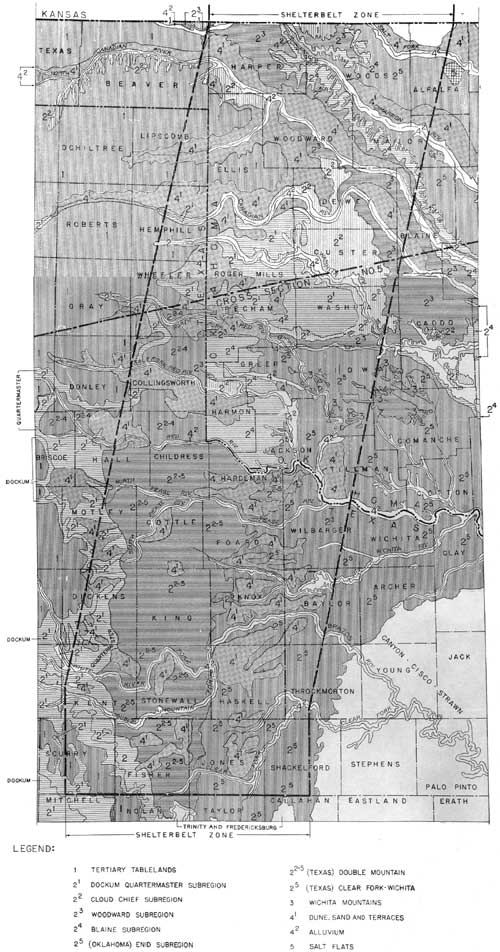
OKLAHOMA-TEXAS
Refer to figure 105, and cross section no. 5, figure 95. The shelterbelt zone in Oklahoma and Texas crosses the "Red Bed" country, bordering the High Plains territory on the west and extending across the lower Permian and upper Pennsylvanian outcrop area on the southeast. The Wichita uplift, in which very old formations are exposed, is the dominant structural feature. The geologic column is given in table 28.
|
| FIGURE 105.—Ground-water regions of shelterbelt zone in Oklahoma and Texas. (click on image for a PDF version) |
TABLE 28.—Geologic column in the shelterbelt zone of Oklahoma and Texas
| Age | Name of formation | Thickness | Lithologic character |
| Feet | |||
| Recent and Pleistocene. | Alluvium | 2-30+ | Silt sand, and gravel. |
| Terrace deposits and dune sand. | 0-100± | Sand and gravel. | |
| Tertiary (late) | "Mortar beds" | 100-300 | Clay, sand, gravel. |
| Triassic | Dockum group | 115-1,000 | Varicolored shales, some sandstones and conglomerates. |
| Permian | Quartermaster | 300± | Soft red sandstones, sandy clays, and shales. |
| Cloud Chief (Greer)1 | 150-300 | Gypsum, red clays, shales, and sandstones. | |
| Woodward1 | 300+± | Red shales, sandstones, and dolomites, | |
| Blaine1 | 75-200 | Red shales, gypsum, thin dolomites. | |
| Enid1 | 1,200-1,500 | Brick-red clay shales with some red and whitish sandstone. | |
| Cambro-Ordovician | Arbuckle | Limestone. | |
| Pre-Cambrian | Wichita Mountain. | Gabbro, granite, porphry and granite. | |
1In Texas the Cloud Chief, Woodward, Blaine, and upper Enid are included in the Double Mountain group (undivided), consisting of red and gray or blue shales and sandstones with dolomites and gypsum, 1,500-2,000 feet thick; the lower Enid is called the Clear Fork group and consists of shale, sandstone, dolomites, and some gypsum, 1,200 feet in thickness. | |||
GROUND-WATER HORIZONS
The surficial deposits of the shelterbelt zone in Oklahoma and Texas which yield ground water are the alluvium of the stream valleys and the dune sand and terrace deposits. Bedrock horizons which are important water sources include the Tertiary sands and gravels; sandstone beds in the Dockum group of Triassic age, and the Quartermaster, Woodward, and Enid formations of Permian age; the limestones of Cambro-Ordovician age; and the pre-Cambrian granite. The Cambro-Ordovician and pre-Cambrian rocks are near the surface only in the vicinity of the Wichita Mountains.
GROUND-WATER REGIONS
The shelterbelt zone in Oklahoma and Texas crosses three main regions, namely, (1) the Tertiary, (2) the "Red Beds," and (3) the Wichita uplift. It includes also groups of scattered areas, namely, (4) the alluvium, terrace, and dune sand areas and (5) the saline flats. No attempt is made here to differentiate the older Permian and the upper Pennsylvanian beds as regions and subregions. Location numbers in the following paragraphs refer to those marked on the map (fig. 105).
TERTIARY REGION (1)
The Tertiary regions consist of clay, sand, and gravel. The rocks appear to be correlative with the Ogallala formation of Kansas and Nebraska. The ground-water conditions are similar to those in the Tertiary region of Kansas. In general, there is a good supply of water at depths of 100 feet or more.
"RED BED" REGIONS (21-25)
The "Red Bed" region, as shown on the map, includes five subregions, as follows:
Subregion 21 is formed on the Dockum group and the Quartermaster formation. The Dockum group is Triassic in age and consists of varicolored shales, with some interbedded sandstones and conglomerates. It overlies the Quartermaster formation unconformably. The Quartermaster formation is made up of soft red sandstones, sandy clays, and shales, and is late Permian (Cimarron) in age. The water from both these horizons is of good quality but often limited in quantity.
Subregion 22, developed on the Cloud Chief or Greer formation, generally yields bad water. The Cloud Chief formation is a series of gypsums, red clays, shales, and sandstones. It is also Cimarron in age.
Subregion 23, on the Woodward formation, consisting of red shales, sandstones, and dolomites, carries good water. The Woodward formation is Permian in age and equivalent to a part of the Cimarron.
Subregion 24, on the Blaine formation, which contains thick beds of gypsum interbedded with red shales and thin dolomites, yields hard water. It is also of Permian (Cimarron) age.
Subregion 25, developed on the red clay shales and sandstones of the Enid formation, has good water with the exception of areas affected by leakage from the overlying Blaine formation. The Enid formation is Permian in age.
The Cloud Chief, Woodward, Blaine, and Enid formations have not been mapped in Texas but are included in the Double Mountain group. It has, therefore, been impossible to trace the various subregions across the State line, although zones similar to those in Oklahoma are known to exist.
The ground water of the "Red Beds" region encountered at shallow depths is generally fair to good; that found at considerable depths is often unsuitable for drinking.
WICHITA UPLIFT REGION (3)
The Wichita Mountains are formed on ancient rocks, as granite, gabbro, and very old limestone. They are flanked by the "Red Bed" formations. The ground water of the granite is said to be soft, and springs are abundant. Water from the heavy lime beds is hard. All told, there is a good water supply in this region.
ALLUVIUM AND DUNE-SAND AREAS (4)
The alluvium and dune-sand areas are in or along the largest valleys of the shelterbelt zone. Generally, they carry a fair grade of water except where there are leakages of highly mineralized water from the overlying gypsiferous and saliferous zones. Most of the water is shallow and soft, medium-hard, or hard.
SALINE AREAS (5)
Salt leakages from the gypsiferous and saliferous upland formations (Cloud Chief or Greer and Blaine) accumulates in flat areas in some of the valleys of the shelterbelt zone in Oklahoma and Texas. These areas are nearly barren.
BIBLIOGRAPHY
The following references were consulted in preparing the descriptions and maps included in the preceding report:
ALDEN, W. C.
1932. PHYSIOGRAPHY AND GLACIAL GEOLOGY OF EASTERN MONTANA AND ADJACENT
AREAS, U. S. Geol. Survey Prof. Paper 174, 133 pp., illus.
BAILEY, E. H. S., with KNERR, E. D., CRANE, W. R., and McFARLAND, D.
F.
1902. SPECIAL REPORT ON MINERAL WATERS. Kans. Univ.
Geol. Survey Rept. v. 7, 343 pp.
BEEDE, J. W., and CHRISTNER, D. D.
1926. THE GEOLOGY OF FOARD COUNTY. Tex. Univ. Bull.
2607: 18-53, illus.
CONDRA, G. E.
1907. GEOLOGY AND WATER RESOURCES OF THE REPUBLICAN RIVER VALLEY AND
ADJACENT AREAS, NEBRASKA.
U. S. Geol. Survey Water-Supply Paper 216, 71 pp., illus.
______
1908. GEOLOGY AND WATER RESOURCES OF A PORTION OF THE MISSOURI RIVER VALLEY
IN NORTHEASTERN NEBRASKA.
U. S. Geol. Survey Water-Supply Paper 215, 59 pp., illus.
______
1930. THE CONSERVATION OF NEBRASKA'S WATER RESOURCES.
Nebr. Univ. Conserv. and Soil Survey Bull. 3,
19 pp.
______
1934. THE RELATION OF DROUTH TO WATER-USE IN NEBRASKA. Nebr. Univ. Conserv.
and Soil Survey Bull. 6, 24 pp., illus.
______
1934. GROUND-WATER RESOURCES OF NEBRASKA. In Report on
Ground-water resources of the Lower Missouri Basin, Natl. Resources Bd.
Rept. 94 pp. [Typewritten.]
______, SCHRAMM, E. F., and LUGN, A. L.
1931. DEEP WELLS OF NEBRASKA. Nebr. Geol. Survey Bull.
4 (Ser. 2), 19 pp., illus.
______ and WAITE, H.
1934. GROUND-WATER RESOURCES OF KANSAS, In Report on Ground-water
Resources of the Lower Missouri Basin. Natl. Resources Bd. Rept. 29 pp.
[Typewritten.]
DARTON, N. H.
1896, PRELIMINARY REPORT ON ARTESIAN WATERS OF A PORTION OF THE
DAKOTAS, U. S. Geol. Survey Ann.
Rept. 17, pt. 2, pp. 603-694, illus.
______
1905. PRELIMINARY REPORT ON THE GEOLOGY AND UNDERGROUND WATER RESOURCES OF
THE CENTRAL GREAT PLAINS. U. S. Geol. Survey Prof. Paper 32, 433
pp., illus.
______
1909. GEOLOGY AND UNDERGROUND WATERS OF SOUTH DAKOTA.
U. S. Geol. Survey Water-Supply Paper 227, 156 pp., illus.
FENNEMAN, N. M.
1923, PHYSIOGRAPHIC PROVINCES AND SECTIONS IN WESTERN OKLAHOMA AND
ADJACENT PARTS OF TEXAS. U. S.
Geol. Survey Bull. 730: 115-139, illus.
FOLGER, A., LEES, J. H., MCQUEEN, H. S., HALL, R. H., BUSH, F. A., and
THWAITES, F. T.
1931. GEOLOGIC CROSS SECTION OF THE CENTRAL UNITED
STAVES. Kans. Geol. Soc. 5th Ann. Field Conf., pp.
64-71, illus.
GORDON, C. H.
1913. GEOLOGY AND UNDERGROUND WATERS OF THE WICHITA
REGION, NORTH-CENTRAL TEXAS, U. S. Geol. Survey
Water-Supply Paper 317, 87 pp., illus.
GOULD, C. N.
1905. GEOLOGY AND WATER RESOURCES OF OKLAHOMA, U. S.
Geol. Survey Water-Supply and Irrig. Paper 148,
178 pp., illus.
HARD, H. A.
1929, GEOLOGY AND WATER RESOURCES OF THE EDGELEY AND LA MOURE
QUADRANGLES, NORTH DAKOTA. U. S.
Geol. Survey Bull, 801, 90 pp., illus.
HAWORTH, E.
1897. UNDERGROUND WATERS OF SOUTHWESTERN KANSAS.
U. S. Geol. Survey Water Supply and Irrig.
Paper 6, 65 pp., illus.
KELLETT, BETTY
1932. GEOLOGIC CROSS SECTION FROM WESTERN MISSOURI TO
WESTERN KANSAS (MAP). Kans. Geol. Soc. 6th Ann Field Conf.
LEONARD, A. G.
1906. STRATIGRAPHY OF NORTH DAKOTA CLAYS. N. Dak.
State Geol. Survey Bien. Rept. 4, pt. 2, pp. 63-94, illus.
______
1916. PLEISTOCENE DRAINAGE CHANGES IN WESTERN NORTH
DAKOTA, Geol. Soc. Amer. Bull. 27: 295-304,
illus.
______
1930. GEOLOGY AND NATURAL RESOURCES CF NORTH DAKOTA.
N. Dak. State Geol. Survey Bull. 9.
LEVERETT, F., and SARDESON F. W.
1932. QUATERNARY GEOLOGY OF MINNESOTA AND PARTS OF
ADJACENT STATES. U. S. Geol. Survey Prof. Paper 161, 149 pp., illus.
MELNZER, O. E., and HARD, H. A.
1925. THE ARTESIAN WATER SUPPLY OF THE DAKOTA SANDSTONE IN NORTH DAKOTA,
WITH SPECIAL REFERENCE TO THE EDGELEY QUADRANGLE. U. S. Geol. Survey
Water-Supply Paper 520, pt. 5, pp. 73-95, illus.
MISER, H. D. (compiler)
1926. GEOLOGIC MAP OF OKLAHOMA. U. S. Geol. Survey,
Geol. Atlas of the U. S.
MOORE, R. C.
1933. GEOLOGICAL MAP OF KANSAS.
______ and HAYNES, W. P.
1917. OIL AND GAS RESOURCES OF KANSAS. Kans. Geol.
Survey Bull. 3, 391 pp., illus.
OKLAHOMA GEOLOGICAL SURVEY.
1930. OIL AND GAS IN OKLAHOMA. Okla. Geol. Survey
Bull. 40, V. 2 and 3, illus.
PARKER, H. N.
1911. QUALITY OF THE WATER SUPPLIES OF KANSAS. U.
S. Geol. Survey Water-Supply Paper 273, 375 pp., illus.
PERRY, E. S.
1934. GROUND-WATER RESOURCES OF UPPER MISSOURI RIVER
BASIN IV, MONTANA, WYOMING, NORTH DAKOTA, AND SOUTH DAKOTA, Rept. to
Howard E. Simpson, Principal Water Geologist, Natl. Resources Bd.
[Typewritten.]
ROTHROCK, E. P
1932. GEOLOGICAL MAP OF SOUTH DAKOTA. S. Dak.
Geol. Survey Pub.
______ and PETSCH, B. C.
1935. A SHALLOW-WATER SUPPLY FOR HURON, SOUTH
DAKOTA. S. Dak. State Geol. Survey, Report of Investigations
24.
SELLARDS, E. H., ADKINS, W. S., and PLUMMER, F. B.
1933. THE GEOLOGY OF TEXAS. V. 1, STRATIGRAPHY,
Tex. Univ. Bull. 3232, 1007 pp., illus.
SIMPSON, H. E.
1929. GEOLOGY AND GROUND-WATER RESOURCES OF NORTH DAKOTA. U. S. Geol.
Survey Water-Supply Paper 598, 312 pp., illus.
______
1932. THE GROUND WATERS OF NORTH DAKOTA, N.Dak. Geol. Survey Bull. 7, 26 pp.,
illus.
SLICHTER, C. S.
1906. THE UNDERLOW IN ARKANSAS VALLEY IN WESTERN
KANSAS. U. S. Geol. Survey Water-Supply Paper
153, 90 pp., illus.
SOUTH DAKOTA GEOLOGICAL SURVEY.
1898. FIRST AND SECOND BIENNIAL REPORTS ON THE GEOLOGY OF SOUTH DAKOTA,
WITH ACCOMPANYING PAPERS. S. Dak. Geol. Survey Bull. (1893-6) 2, 139 pp., illus.
TAFF, J. A.
1904. PRELIMINARY REPORT ON THE GEOLOGY OF THE ARBUCKLE AND
WICHITA MOUNTAINS IN INDIAN TERRITORY AND OKLAHOMA.
U. S. Geol. Survey Prof. Paper 31, 97 pp., illus.
THOMPSON, D. G.
1921. GROUND WATER FOR IRRIGATION NEAR GAGE, ELLIS COUNTY, OKLAHOMA, U.
S. Geol. Survey Water-Supply Paper 500-B: 33-53, illus.
TODD, J. E.
1899. THE MORAINES OF SOUTHEASTERN SOUTH DAKOTA AND THEIR ATTENDANT
DEPOSITS.—U. S. Geol. Survey Bull. 158, 171 pp., illus.
______
1903. MITCHELL FOLIO, SOUTH DAKOTA. U. S. Geol. Survey,
Geol. Atlas of U. S., Folio 99, 7 pp., illus.
Ann. Field Conf.
______
1903. OLIVET FOLIO, SOUTH DAKOTA. U. S. Geol. Survey, Geol. Atlas of U.
S., Folio 96, 6 pp., illus.
______
1903. PARKER FOLIO, SOUTH DAKOTA. U. S. Geol. Survey,
Geol. Atlas of U. S., Folio 97, 6 pp., illus.
______
1904. HURON FOLIO, SOUTH DAKOTA. U. S. Geol. Survey
Geol. Atlas of U. S., Folio 113, 6 pp., illus.
______
1909. ABERDEEN-REDFIELD FOLIO, SOUTH DAKOTA. U. S. Geol.
Survey, Geol. Atlas of U. S., Folio 165, 13 pp., illus.
______ and HALL, C. M.
1903. ALEXANDRIA FOLIO, SOUTH DAKOTA. U. S. Geol. Survey, Geol. Atlas
of U. S., Folio 100, 6 pp., illus.
______ and HALL, C. M.
1904. GEOLOGY AND WATER RESOURCES OP PART OF THE LOWER JAMES RIVER
VALLEY, SOUTH DAKOTA. U. S. Geol. Survey Water-Supply Paper 90, 47 pp., illus.
WILLARD, D. E.
1909. JAMESTOWN-TOWER FOLIO, NORTH DAKOTA. U. S. Geol.
Survey, Geol. Atlas of U. S., Folio 168, 10 pp.,
illus.
WILMARTH, M. GRACE (compiler)
1926-31. TENTATIVE CORRELATION OP THE NAMED GEOLOGIC UNITS OF THE
VARIOUS STATES OF THE UNITED STATES. U. S. Geol. Survey (pub. in
separate sheets).
| <<< Previous | <<< Contents>>> | Next >>> |
|
shelterbelt/sec12.htm Last Updated: 08-Jul-2011 |