|
National Park Service
Confinement and Ethnicity An Overview of World War II Japanese American Relocation Sites |

|
Chapter 11
Rohwer Relocation Center
The Rohwer Relocation Center was located in Desha County, Arkansas, 11 miles north of McGehee and 110 miles southeast of Little Rock. It was one of two relocation centers in Arkansas — 27 miles south was the Jerome Relocation Center. The relocation center was named after the community of Rohwer, which was located one-half mile south.
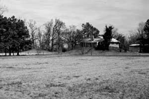 Figure 11.1. Residence south of Rohwer on top of a suspected Indian mound (another Indian mound is to the left of the house). |
Five miles west of the Mississippi River and at an elevation of 140 feet, the relocation center area is intertwined with canals, bayous, creeks, and swampy areas. The forests that once covered the area are now gone, replaced with rice, soybean, and cotton fields and dispersed housing. About 1 mile south of the relocation center, on the east side of State Highway 1, there are Indian mounds, one with a residence on it (Figure 11.1).
Several sources indicate the relocation center reserve encompassed 10,161 acres, but a boundary map for the entire reserve could not be located for this report. However, the central area layout plan includes a vicinity map which may provide clues to the boundary. Twenty full sections and four partial sections around the central area are numbered on the map, whereas the other sections depicted on the map are not numbered. While the total area of these sections exceeds the reported 10,161 acre figure, the relocation center reserve was likely limited to lands within these sections (Figure 11.2).
 Figure 11.2. Rohwer Relocation Center. (click image for larger size (~70K) ) |
According to Bearden (1989), half of the relocation center reserve remained under swampy bayou water during the spring. The reserve was mostly on public land meant for subsistence homesteads under the Farm Security Administration; the balance was purchased from local farmers.
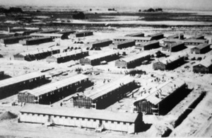 Figure 11.3. Construction underway at the Rohwer Relocation Center. (WRA photograph, National Archives) |
The roughly 500-acre central area of the relocation center was along the west side of State Highway 1 and the adjacent Missouri Pacific Railroad. Construction by the Linebarger-Senne Construction Company of Little Rock, Arkansas, began July 1, 1942, and the center was ready for use on September 18, 1942 (Figure 11.3). The maximum population, reached in November 1942, was 8,475. Evacuees were from California, who endured a three-day train ride from the assembly centers to reach Arkansas. The center closed November 30, 1944.
Rosalie Gould, the former Mayor of McGehee, grew up in the area, and recounts that the Arkansas relocation centers were located in very poverty-stricken areas, probably, she believes, at the insistence of some influential Arkansas senator. In spite of local expectations, the centers did not bring prosperity. Hence, as difficult as conditions were within the relocation center, some local residents envied the evacuees' access to regular meals and health care.
The relocation center at Rohwer was divided into 51 blocks surrounded by a barbed wire fence, a patrol road, and eight watch towers (Figures 11.4 and 11.5). All of the blocks were on a north-south grid. The southern two-thirds of the central area were residential blocks; warehouses were located in the northeast corner just north of the main entrance, which was along the east side. The administration and hospital areas lay to the west of the warehouses, and the military police compound was along the east boundary just south of the main entrance.
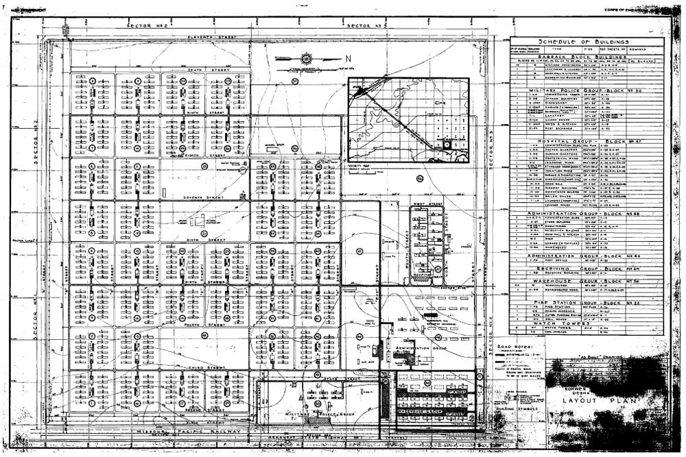 Figure 11.5. Rohwer Relocation Center central area. (click image for larger size (~172K) ) |
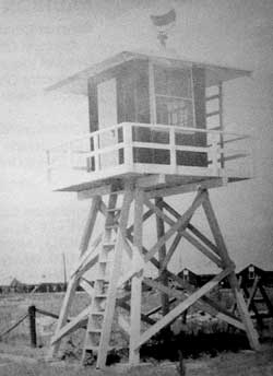 Figure 11.4. Watch tower at Rohwer. (from Rohwer Reunion Committee 1990) |
East-west roads were designated by letters; north-south roads by numbers. "I" Street (also known as "Eye") was the main entrance road, extending west from the entrance and perpendicular to State Highway 1 and the Missouri Pacific Railroad. There was also an entrance along the west side of the central area near the southwest corner, and the warehouse area had two openings through the fence for access to a railroad siding (Figures 11.6 and 11.7).
There were over 620 buildings at the center. The military police compound (designated Block 30), included 12 buildings. Across the road from the military police compound was the receiving building at the main entrance. The administration area (Block 44) also had 12 buildings when first built, but up to 15 staff apartment buildings were later constructed using evacuee labor (Figure 11.8). The warehouse area (Block 50) had 21 buildings, and the hospital area (Block 47) had 17 buildings. An area north of the warehouses was used for coal storage (Block 51). Blocks 44 and 45, along Eye Street, included the post office, a sawmill, a plumbing shop, and three warehouses. There were also three other warehouses along Eye Street in Blocks 30 and 47. A cannery was located north of the hospital.
The 36 residential blocks were located south of the administration area. They lay within a rectangle eight blocks east-west by six blocks north-south. To combat muddy conditions each block was surrounded by a drainage ditch, and gravel and wooden sidewalks were constructed between the barracks (Figures 11.9 and 11.10). The southwest portion of the residential area was an especially low area, which after rains would become flooded even above the level of the wooden sidewalks. Sometimes buildings had to be sandbagged to prevent them from being flooded (Rohwer Reunion Committee 1990).
Each residential block had twelve 20-foot-by-120-foot barracks, a recreation building, a mess hall, and a combined bathroom and laundry building. Many evacuees planted vegetable and flower gardens to beautify their new homes (Figures 11.11 and 11.12). Recreation buildings were used for stores, churches, movies, girl and boy scout meetings, a toy library, YWCA, Judo, boxing, weaving, sewing, and other activities (Rohwer Outpost October 1989). All the standard buildings in residential Blocks 31 and 35 were used for elementary and high schools (Rohwer Outpost 11/7/42), and Block 35 had an extra building built for school use. Well houses were located in Blocks 23 and 38 of the residential area.
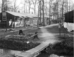 Figure 11.10. Drainage ditch in residential block at Rohwer. (Gretchen Van Tassel photograph, Bancroft Library, University of California, Berkeley) |
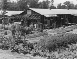 Figure 11.11. Evacuee garden at Rohwer. (Charles E. Mace photograph, Bancroft Library, University of California, Berkeley) |
Some of the residential blocks had special functions and therefore had different configurations of buildings, or no buildings at all. Block 21 had only a school auditorium and school library, Block 36 had a school shop, and Block 22 had a fire house, a pumping station, a reservoir, and an unidentified building. Blocks 18, 37, and 45 were open areas.
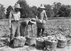 Figure 11.14. Harvesting cucumbers at Rohwer. (Charles E. Mace photograph, Bancroft Library, University of California, Berkeley) |
Outside the fenced central area the evacuees dug ditches and cleared land for farming. The Rohwer and Jerome relocation centers grew 85 percent of their own vegetables (Bearden 1989). In 1943, 610 acres were under cultivation at Rohwer, in 1944, 577 acres (Figures 11.13 and 11.14). The evacuees also raised hogs and chickens for their own consumption. The hog and chicken farm locations are not known, but they likely utilized existing farm buildings within the relocation center reserve.
As at the Jerome Relocation Center, evacuees working outside the fenced area were subject to harassment caused by mistaken identity. Early in the relocation center occupation, evacuee volunteers clearing brush were reportedly taken off to a local jail at gunpoint by local residents who thought they were Japanese paratroopers (Hayashi 1997).
When the relocation center was closed, 120 acres were deeded to the local school district and the rest was sold back to the original farmers or to veterans. The Desha Central High School originally used two of the hospital buildings (Stuart 1979), the high school auditorium, and perhaps other relocation center buildings. However, none of these remain today. Equipment and buildings were also sold to bidders across the country; some barracks are still in use on the Southern Illinois University campus (Hoshiko 1988).
 Figure 11.6. Evacuees unloading boxcar at Rohwer. (Tom Parker photograph, Bancroft Library, University of California, Berkeley) |
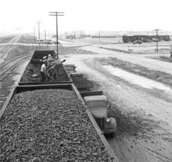 Figure 11.7. Evacuees unloading coal at Rohwer. (Tom Parker photograph, Bancroft Library, University of California, Berkeley) |
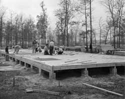 Figure 11.8. Evacuees building staff apartment at Rohwer. (Tom Parker photograph, Bancroft Library, University of California, Berkeley) |
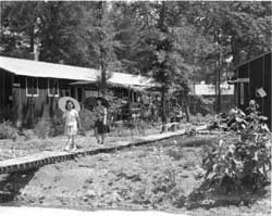 Figure 11.9. Wooden sidwalk at Rohwer. (Charles E. Mace photograph, Bancroft Library, University of California, Berkeley) |
|
Figure 11.10. Drainage ditch in residential block at Rohwer. (Gretchen Van Tassel photograph, Bancroft Library, University of California, Berkeley) |
Figure 11.11. Evacuee garden at Rohwer. (Charles E. Mace photograph, Bancroft Library, University of California, Berkeley) |
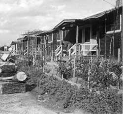 Figure 11.12. Barracks residence at Rohwer. (Gretchen Van Tassel photograph, Bancroft Library, University of California, Berkeley) |
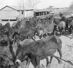 Figure 11.13. Farm mules at Rohwer. (Tom Parker photograph, Bancroft Library, University of California, Berkeley) |
Central (Fenced) Area
Today the relocation center site is partly agricultural fields and partly developed with scattered houses and the Desha Central High School. A few relocation center road segments remain, including portions of Eye, D, F, 6th, and 7th streets. The concrete water reservoir and the hospital boiler room smokestack are the only standing structures.
Hospital, Administration, and Warehouse Areas
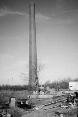 Figure 11.16. Hospital boiler house smokestack. |
The northern third of the central area now includes a residential area and Desha Central High School. Side-by-side near the high school are the foundations from the hospital laundry room and boiler house (Figure 11.15). Adjacent to the boiler house foundation, in apparently stable condition, is a 100-foot-tall red brick smokestack (Figure 11.16). Another intact slab, that of the hospital mess hall, is just behind one of the many buildings of the high school complex (Figure 11.17).
The present high school auditorium, made of yellow concrete block, looks very similar in form to relocation center buildings (Figure 11.18). However, the current building does not date to the relocation center as has been suggested (Hoshiko 1992). The relocation center auditorium was used by the high school following closure of the center, but it was constructed of wood and burned down in the 1950s (Figure 11.19). According to WRA blueprints, the original auditorium was over 2,000 feet south of the present auditorium.
In the administration area there are now numerous homes, a church, and other buildings (Figure 11.20). Only a few features remain. A short concrete drive north of what was once Eye Street appears to be from the relocation center. Just south of the former Eye Street is the slab and concrete vault of the post office (Figure 11.21). Amongst the houses there are also scattered small concrete slabs and an isolated section of sidewalk that may be associated with the relocation center.
In the northeastern portion of the relocation center there are debris and foundation remnants from warehouses. The railroad siding that serviced the relocation center is gone, and the railroad itself has been recently abandoned (Figure 11.22). It is posted at all road crossings as owned by Arkansas State Parks.
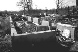 Figure 11.15. Hospital boiler house foundation at Rohwer. |
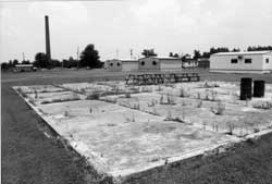 Figure 11.17. Concrete slab of the hospital mess hall at Rohwer. |
 Figure 11.18. Delta Central High School auditorium. |
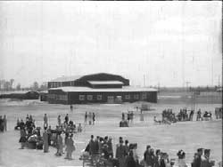 Figure 11.19. High school auditorium at the Rohwer Relocation Center. (from Nakamura 1994) |
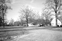 Figure 11.20. Residences within the former administration area at Rohwer. |
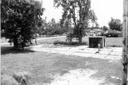 Figure 11.21. Remains of the relocation center post office at Rohwer. |
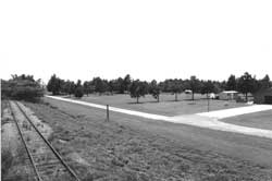 Figure 11.22. Railroad and warehouse area at Rohwer today. |
|
Central (Fenced) Area
Residential Area
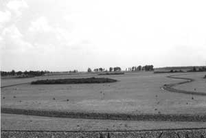 Figure 11.23. Former residential area at Rohwer, now a rice field. Dark vegegation patch is rubble where concrete foundations from the mess hall and bathroom/laundry buildings have been consolidated. |
From "D" Street south, the former residential is under active rice cultivation; from "D" Street north there is currently scrub growth in fallow fields. The concrete slab latrine and mess hall foundations have been broken up and consolidated within each block to increase the area available for crops (Figure 11.23). The consolidated rubble areas are present at all blocks except 9, 10, 24, and 25, and the few remaining relocation center roads help demarcate the location of blocks within the fields. Each rubble area, roughly 100 feet by 300 feet in size, appears to include at least a portion of an intact slab, as well as fragments of cast iron pipe and bricks. All are overgrown by nearly impenetrable brush, trees, and thorny vines. On a few of the slabs are toppled concrete boxes, whose original use is not evident (Figure 11.24).
At Block 21, the rubble mound includes slab foundation debris possibly from the relocation center school auditorium and library. Block 22 is marked by the concrete water reservoir, which is still standing. Measuring 75 feet in diameter by 15 feet tall, it is almost completely hidden by vegetation (Figure 11.25). Just east of the reservoir, at the former location of the relocation center fire station, there is a dense growth of vegetation covering a concrete slab and rubble.
Near the water reservoir, within what was Block 38, there is a well house in the same location as one depicted on WRA blueprints (Figure 11.26). Made of concrete block rather than wood, the building likely rests on the original relocation-center-era concrete slab. According to a local resident, the relocation center water system is still used to supply water for area homes.
Other portions of the relocation center's subsurface utilities remain buried but are currently unused, such as a sewer line exposed by an irrigation ditch (Figure 11.27). The only artifacts seen in the fields were some brick and concrete fragments. No domestic trash dump, or even scattered domestic trash, was observed.
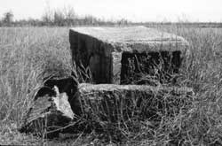 Figure 11.24. Concrete debris on concrete slab in rice field at Rohwer. |
 Figure 11.25. Concrete water reservoir at Rohwer today. |
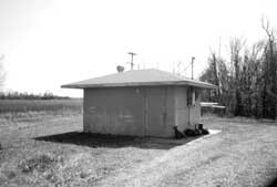 Figure 11.26. Modern well house at the site of a relocation center well (Block 38). |
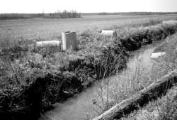 Figure 11.27. Exposed and displaced sewage pipe at Rohwer. |
Security Features
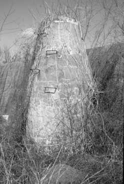 Figure 11.29. Manhole at the Rohwer sewage treatment plant. |
No evidence of the original perimeter fence or watch towers remain. In the former military police compound, there is a residence and a fallow field.
Outlying Areas
No records or maps of any outlying features other than the relocation center cemetery and sewage treatment plant have been found. A cursory inspection of the surrounding area suggests that no features likely remain.
Sewage Treatment Plant
Now surrounded by rice fields, the sewage treatment plant was located west of the southwest corner of the central area. It is similar in design to the plant at the Jerome Relocation Center, but smaller and with no evidence of filter rock beds (Figures 11.28 and 11.29). Access to the sewage treatment plant is via a dirt road that becomes nearly impassably muddy during wet weather.
Cemetery
The relocation center cemetery, enclosed by concrete fence posts, includes 24 uniform cast concrete headstones, two large concrete monuments, a toppled concrete bench, a flagpole, sidewalks, and two concrete entrance markers facing towards the relocation center, all built by the evacuees (Figures 11.30-11.33). Interestingly, the cemetery is not shown on WRA blueprints. The present approach road was probably part of the former "A" Street, which was part of the patrol road that encircled the outside of the barbed wire perimeter fence (Figure 11.34).
One monument, in the shape of a military tank, is to the Japanese Americans in the 100th Battalion and the 442nd Regimental Combat Team who were killed in Italy and France (Figure 11.35). The second monument is to those who died in the relocation center (Figure 11.36). It has both Japanese and English inscriptions. The Japanese translates to: "May the people of Arkansas keep in beauty and reverence forever this ground where our bodies sleep." The English inscription reads: "Erected by the inhabitants of Rohwer Relocation Center October 1944." Two recent monuments at the cemetery are discussed below.
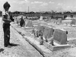 Figure 11.30. Rohwer Relocation Center cemetery in July 1943. (Charles E. Mace photograph, Bancroft Library, University of California, Berkeley) |
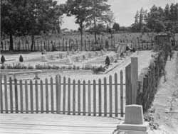 Figure 11.31. Rohwer Relocation Center cemetery in June 1994. (Charles E. Mace photograph, Bancroft Library, University of California, Berkeley) |
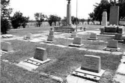 Figure 11.32. Rohwer Relocation Center cemetery today. |
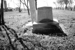 Figure 11.33. Rohwer Relocation Center cemetery. |
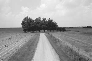 Figure 11.34. Road to Rohwer Memorial cemetery. | |
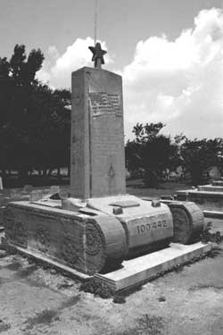 Figure 11.35. Monument to the 100th Battalion and 442nd Regimental Combat Team, erected by evacuees during the wae. |
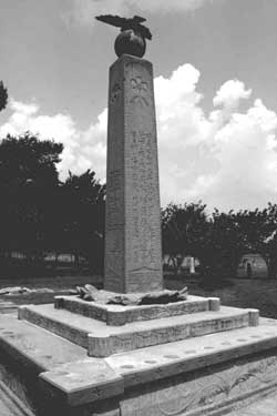 Figure 11.36. Monument to those who died at the Rohwer Relocation Center, erected by evacuees in 1944. |
Interpretation
Signs along State Highway 1 direct passersby to the Rohwer Memorial Cemetery (Figure 11.37). The cemetery area is very neat and well kept, recently weeded, and has a few new concrete fence posts. In addition to the two relocation-center-era concrete monuments at the cemetery, there are two recent granite monuments (Figure 11.38). One honors the 31 Japanese Americans soldiers from Rohwer who were killed during World War II (Figure 11.39). The second, smaller, monument commemorates the relocation center, and indicates the cemetery is a National Historic Landmark (Figure 11.40).
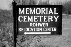 Figure 11.37. Sign along State Highway 1. |
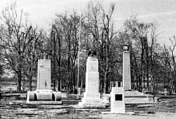 Figure 11.38. Monuments at the Rohwer Cemetery. |
The cemetery area was listed on the National Register of Historic Places in 1974 and designated a National Historic Landmark in 1992, due in large part to the efforts of Rosalie Gould, the former mayor of McGehee, who has been very active in researching and preserving the site. Presently, she is working to create a small museum in McGehee to house the various photographs, newspaper articles, and other materials she has collected about the Rohwer and Jerome relocation centers.
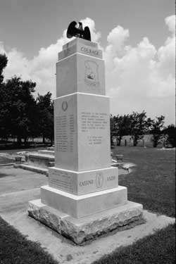 Figure 11.39. Recent monument to Japanese American soldiers from Rohwer killed during World War II. |
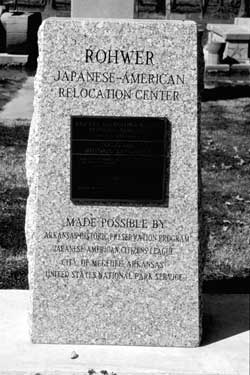 Figure 11.40. National Historic Landmark monument. |

|

|
| <<< Previous | <<< Contents>>> | Next >>> |
wacc/74/chap11.htm
Last Updated: 20-Feb-2004