|
National Park Service
Confinement and Ethnicity An Overview of World War II Japanese American Relocation Sites |

|
Chapter 12
Topaz Relocation Center
The Topaz or Central Utah Relocation Center was located in west-central Utah, in Millard County near the town of Delta, 140 miles southwest of Salt Lake City. The relocation center named after Topaz Mountain, 9 miles northwest. The relocation center was briefly known as the "Abraham Relocation Center," after a nearby settlement (Figure 12.1).
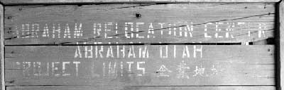
Figure 12.1. Sign at the Great Basin Museum in Delta, Utah.
The extremely flat terrain of the relocation center lies within the Sevier Desert, part of the Basin and Range province that was once covered by Pleistocene Lake Bonneville. An "Old River Bed" depicted on maps less than a mile west of the site drains northward to the Topaz Slough. The most prominent physical landmark in the vicinity is Smelter Knolls, 4 miles west. Elevation at the Topaz Relocation Center is about 4600 feet and the native vegetation consists mainly of high desert brush.
The 19,800-acre relocation center reserve was a mixture of public domain land, farms acquired by the county for non-payment of taxes, and several privately-held parcels purchased for a dollar an acre (Arrington 1962). Construction of the relocation center was begun July 10, 1942, by the California firm Daley Brothers with a crew of 800.
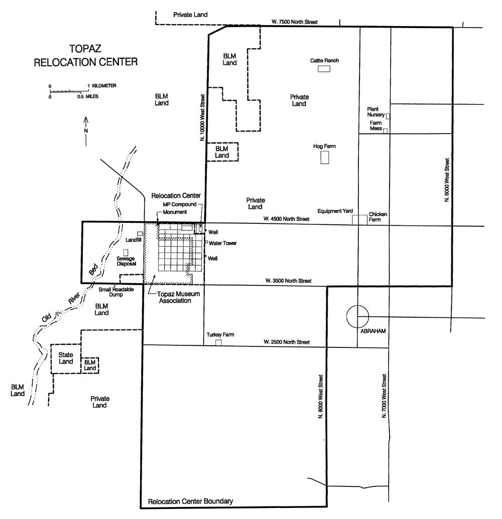
Figure 12.2. Topaz Relocation Center.
(click image for larger size (~64K) )
The relocation center was in operation from September 11, 1942, to October 31, 1945. The maximum population was 8,130; most of the internees were from the San Francisco Bay area. A total of 623 buildings were constructed during the life of the relocation center (Powell 1972). The nucleus of the facility consisted of a one-square-mile area for residents, administrative personnel, and the military police (Figures 12.2-12.5). This "central area" included 42 blocks, eight for administration and 34 for residences. Each residential block had 12 barracks, a mess hall, a recreation hall, and a combination washroom, shower, toilet, and laundry building. The eight administration blocks included office buildings, staff housing, warehouses, a hospital, and a military police compound. Security features at Topaz included a sentry post at the entrance, a perimeter fence, seven watch towers, and a military police compound.
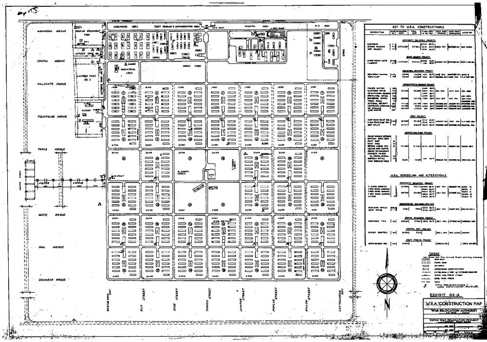
Figure 12.3. Residential and administration area, Topaz Relocation Center.
(National Archives)
(click image for larger size)
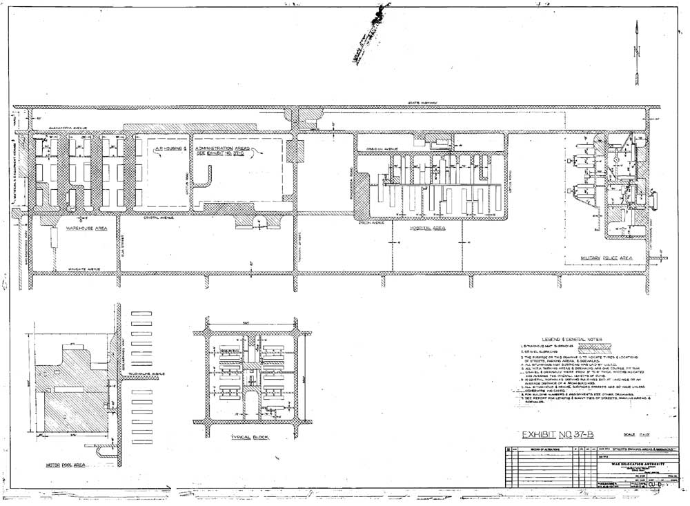
Figure 12.4. Administration area, hospital, and military police compound, Topaz Relocation Center.
(National Archives)
(click image for larger size)
 Figure 12.5. Panorama view of the Topaz Relocation Center. (Francis Stewart photograph, Bancroft Library, University of California, Berkeley) |
Some of the buildings at Topaz were imported, recycled from nearby Civilian Conservation Corps (CCC) camps. For example, two buildings were moved from the Antelope Springs CCC camp to Topaz to be used as the Christian and Buddhist churches, and two garages and other buildings were moved from the Black Rock CCC camp (Kelsey 1996:99). During World War II the headquarters of the Buddhist Church of America was transferred to Topaz from San Francisco (Ulibarri 1972).
In addition to the typical relocation center array of buildings and other developments, there were also sports fields and facilities, evacuee-constructed ponds and ornamental gardens, victory gardens to grow food, and trees and other vegetation. Over 7,500 trees and 10,000 shrubs were planted during the first 9 months, however nearly all died due to the heat, wind, and alkaline soil (Arrington 1962).
A cemetery was built to the southeast of the central area, but was never used. The 144 persons who died at Topaz were instead sent to Salt Lake City for cremation and their ashes were held at the relocation center for burial in the San Francisco area after the war (Arrington 1962).
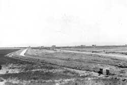 Figure 12.6. Irrigation ditch constructed by evacuees. (Ray T. Woodhull photograph, Bancroft Library, University of California, Berkeley) |
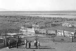 Figure 12.7. Corral at the relocation center hog farm. (Tom Parker photograph, Bancroft Library, University of California, Berkeley) |
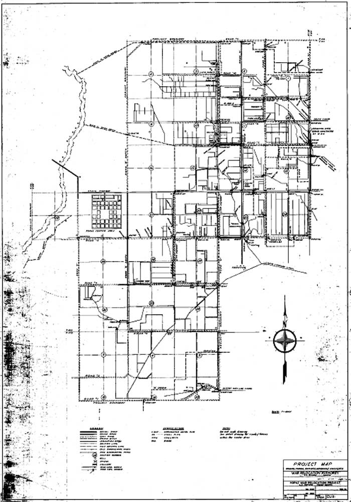 Figure 12.8. Irrigation ditches at the Topaz Relocation Center. (National Archives) (click image for larger size) |
Much of the 19,800-acre relocation center area was devoted to raising food for the center (Figures 12.6-12.8). Beyond the central fenced area were agricultural fields, irrigation ditches, a farm nursery, a chicken farm, a turkey farm, a cattle ranch, a hog farm, a farm equipment storage yard, and a farm workers kitchen, as well as a sanitary landfill and sewage treatment system.
Even further afield, the CCC camp at Antelope Springs, 90 miles west of Topaz, was converted for use as a recreation site. Remains at the Antelope Springs camp are described in Chapter 16. The Deer Creek and Castle Valley mines in central Utah initially supplied coal to the relocation center. Within a short time, however, a group of Japanese American miners was sent from Topaz to operate the Dog Valley Mine south of Emery. Buildings from the Willow Springs CCC camp were moved to the mine to serve as housing for the miners (Geary 1997).
The administration came up with an elaborate address scheme for the evacuees, apparently to give the outside world the impression that Topaz was a normal city. All roads were given names: east-west roads were named after gem stones and north-south streets were named after plants. Each block was then designated by a four digit number (1100-6700) to which the barracks and apartment number was added, which was then appended to the adjacent street. So mail to Apartment A, Barracks 11, Block 39 would instead be addressed to 6411-A Juniper Street, Topaz, Utah.
 Figure 12.9. James Wakasa funeral. (Russell A. Bankson photograph, Bancroft Library, University of California, Berkeley) |
However, Topaz was far from being a normal city. On Sunday, April 11, 1943, 63-year-old James Hatsuaki Wakasa was fatally shot in the chest by a military guard (Figure 12.9). Wakasa was near the perimeter fence about 300 feet from a watch tower and was either distracted or unable to hear or understand the guard's warnings. Guards had fired warning shots at others on eight previous occasions. To avoid further incidents, the administration restricted the military in their use of weapons and access to the relocation center. Nevertheless, a guard fired at a couple strolling too close to the fence, a little more than a month later (Taylor 1993:141).
Central (Fenced) Area
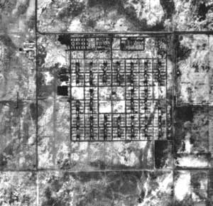 Figure 12.10. Aerial view of the Topaz Relocation Center, 1993. (Bureau of Land Management, Fillmore, Utah) |
Prior to 1998, all of the residential and administrative portions of the relocation center site were owned by a local farmer, Mervin Williams, who lives in a mobile home placed on a concrete slab that was once the Block 28 mess hall foundation. In 1998 the Topaz Museum Board bought 417 acres from Mr. Williams to protect the relocation center site from development. Mr. Williams retained his home in Block 28, trailers and buildings in the adjacent blocks (35 and 42), and other areas along West 4500 North Street.
There are no World War II-era buildings remaining in the central portion of the relocation center, but concrete foundations are present at former latrines, mess halls, and warehouses, and at buildings in the administration area (Figure 12.10). Manholes remain and the internal roads are still evident, with some distinguishable by the original asphalt and others surfaced with gravel cinders (Figures 12.11 and 12.12).
The sentry post location at the main entrance to the relocation center is marked by some building debris and white-washed boulders. The entrance road leads south to a short stone masonry wall which outlines a parking area, with paths leading to the administration building (Figure 12.13). Further south is the fire station slab, a two-bay building with evidence of a shower, toilet, and washroom facilities (Figures 12.14 and 12.15). The only inscriptions seen at Topaz were a few partial names on the concrete entry ramp of the fire station. Numerous other concrete slabs, mostly from warehouses, occur in the administration area, as well as a few small entryway slabs of other building. There is one large concrete slab in the former garage area.
Two concrete slabs remain in the hospital area and there is a concrete coal-storage bin just north of the hospital area (Figure 12.16). From the bin a conveyor fed the coal to the adjacent furnace which generated heat for the hospital buildings. Structural brick and firebrick are still scattered around, and some parts of the conveyor belt system are still present at the bottom of the bin. Nearby, dozens of stove pipe elbows are concentrated in an old gravel parking lot (Figure 12.17). They were likely collected for recycling after the relocation center closed, but never reused.
In the residential blocks there are concrete slabs from the latrines/laundries and the mess halls, some broken, some intact (Figure 12.18). Where the barracks buildings had been there are abundant nails, pieces of tar paper, small boards, stove pipe, brick fragments, and ceramic electrical parts. There are still cooking stoves at several of the mess hall foundations in the eastern portion of the site (Figure 12.19). A concrete wash tub was found, broken and loose, on one of the latrine/laundry slabs (Figure 12.20).
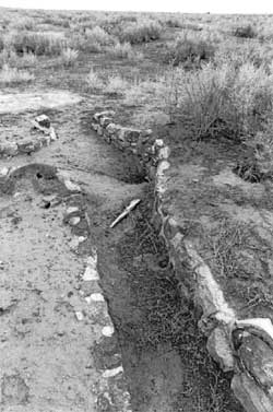 Figure 12.22. Rock-lined ditch and culvert. |
Remnants of raised gravel walkways are common in the barracks area. There was apparently little rock used in landscaping, no doubt due to the paucity of naturally occurring rock in the area. Only a few rock-outlined gardens and one small pond was seen. Other rock work now visible is limited to a rock-lined ditch and culvert at the northwest end of Block 4 (Figure 12.22), and concrete and gravel paths with scattered rocks and boulders at the location of the Buddhist church in Block 17. Much of the details of walkways and paths within the residential area were probably destroyed when the pipes of the water system were dug up for salvage. Other recent ground disturbance has been caused by the construction of ditches to drain surface water.
Very little evidence of athletic fields or other recreational areas was seen. There were no signs of the football field or basketball courts known to have been in Blocks 24 and 25. Baseball backstop remnants were found in Blocks 15, 24, and 25 (Figure 12.23). The area south of Blocks 36 and 37, which contained several baseball fields and other sports facilities, now exhibit only discarded trash and debris.
 Figure 12.11. Overview of the Topaz site. |
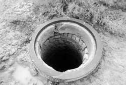 Figure 12.12. Manhole in Block 4 at the Topaz Relocation Center. |
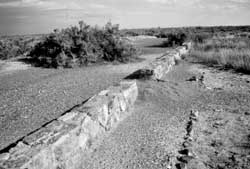 Figure 12.13. Rock wall in the administration area. |
 Figure 12.14. Topaz fire station. (Francis Stewart photograph, Bancroft Library, University of California, Berkeley) |
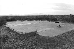 Figure 12.15. Topaz fire station today. |
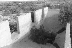 Figure 12.16. Concrete hopper north of the hospital area. |
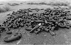 Figure 12.17. stove pipes near the hospital location. |
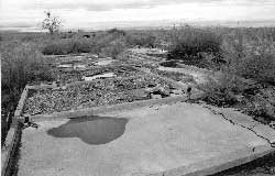 Figure 12.18. Latrine and laundry room slab. |
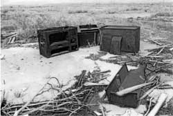 Figure 12.19. Stoves on mess hall slab. |
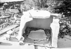 Figure 12.20. Concrete sink on latrine and laundry room slab. |
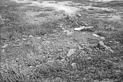 Figure 12.21. Rock work at the location of Barracks I, Block 14. |
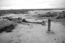 Figure 12.23. Remnants of baseball backstop in Block 15. |
Security Features
Recently constructed ramps in the northeast portion of the central area has caused extensive disturbance to the military police compound. Very little remains there besides three small concrete slabs, one recently modified by a crude rock and concrete wall (Figure 12.24).
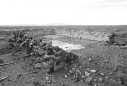 Figure 12.24. Rock and concrete wall at the military police compound. |
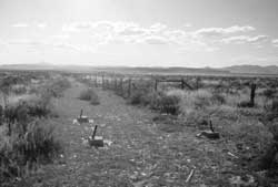 Figure 12.25. Watch tower foundation and intact portion of the western perimeter fence. |
On the west, south, and east sides of the relocation center, portions of the perimeter security fence still remain. Foundations of three of the seven watch towers are still in place (Figure 12.25). At the location of two of the other watch towers, the foundations, though pulled out of place, are nearby. Eight other likely watch tower foundation remnants (large formed-in-place concrete blocks) have been used to make a low wall at the driveway entrance to Mr. Williams's home in Block 28.
Outlying Features
The relocation center landfill is on the west side of the relocation center's residential and administrative area, on federal land currently administered by the Bureau of Land Management. The landfill has suffered extensive vandalism and apparent collecting: there are numerous freshly dug holes, and compared to the other relocation center landfills examined, there are very few Japanese ceramics visible on the surface (Figures 12.26 and 12.27).
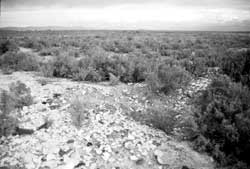 Figure 12.26. Topaz Relocation Center landfill. |
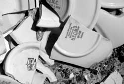 Figure 12.27. Government-issued ceramics at the Topaz Relocation Center landfill. |
Sewage disposal consisted of a large septic system. Besides the remains of a concrete collection box adjacent to Block 22, no tangible remains were observed. From the collection box, sewage was apparently pumped westward to settling ponds.
Many features related to the outlying agricultural facilities, including the chicken, turkey, hog, and cattle farms, the farm kitchen, and an equipment storage area, could be relocated using WRA blueprints (Figure 12.28). The chicken, hog, and cattle farms and possibly the farm kitchen appear to have incorporated structures from pre-re-location center farms. The farm buildings at the hog farm are still in use by the current owner, Mr. Nelson, but the others are abandoned.
 Figure 12.28. Outlying farm buildings, Topaz Relocation Center. (National Archives) (click image for larger size) |
The chicken farm is located 2-1/2 miles east of the residential portion of the relocation center, at the northeast corner of the intersection of 4500 North Street and 7500 West Street. WRA blueprints show a farm house, a bunk house, a generator shed, a feed storage building, a water tank and pump house, eight 22-foot by 45-foot laying houses, and five 22-foot by 100-foot laying houses. The house, bunk house, and some of the laying houses are still standing, although currently not used. The house has a basement and adobe walls with a wire mesh and stucco veneer (Figure 12.29); the bunk house is stucco over wood frame. The laying houses were likely built by the evacuees. Made of adobe block and concrete mortar with wooden roofs, they are in various stages of decay (Figures 12.30-12.32). Located across the road from the chicken farm was an equipment storage area. Currently the area contains some building debris, a possible structure location, and a couple of small trash piles.
The relocation center turkey farm was located on the north side of 2500 North Street, 0.2 mile east of the intersection of 10000 West Street. Remains at the turkey farm include a single low concrete-walled coop 23-1/2 feet by 50 feet in size (Figures 12.33 and 12.34).
The hog farm was located about 2 miles northeast of the residential area, at the northwest corner of 5500 North Street and 8000 West Street. Presently occupied, buildings there include a house (noted as a kitchen and an attached shed on WRA blueprints), a feed bin, and several smaller structures.
The cattle ranch is about 3-1/2 miles northeast of the residential area of the relocation center, at the northwest corner of 7000 North Street and 8000 West Street. Structures remaining at the cattle ranch include a bunkhouse, a feed storage barn, a chicken shed, a well house, and several corrals (Figures 12.35 and 12.36). Three small shacks noted on WRA blueprints are no longer present.
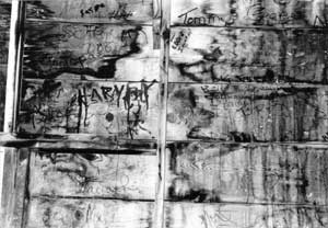 Figure 12.41. Graffiti at the Topaz Farm Kitchen. |
At the farm kitchen, located 0.2 mile west of the intersection of 6000 North Street and 7000 West Street, there is a barn, garage, shed, and well (Figure 12.37 and Figure 12.38). The barn and garage, certainly in place during use of the relocation center, may have been constructed by the evacuees. Both are made of the same kind of lumber as was commonly used at the relocation centers, and the barn has numerous names, dates, home towns, and other graffiti written by the evacuees on the interior of the west wall (Figures 12.39-12.41). In amongst the graffiti there are several undecipherable Japanese characters. The barn is similar in size and design to a relocation center mess hall, and may be the "Farm Kitchen" itself.
The plant nursery location, depicted on the WRA blueprints as about one-quarter mile north of the farm kitchen, is now a cultivated field.
 Figure 12.29. Frm house at the Topaz Chicken Farm. |
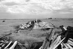 Figure 12.30. Collapsed laying houses at the Topaz Chicken Farm. |
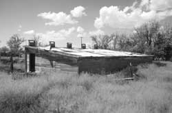 Figure 12.31. Laying house at the Topaz Chicken Farm. |
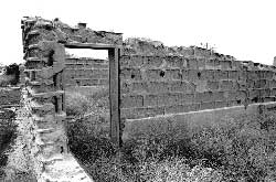 Figure 12.32. Adobe wall at the Topaz Chicken Farm. |
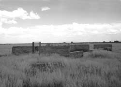 Figure 12.33. Building remains at the Topaz Turkey Farm. |
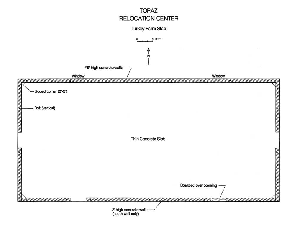 Figure 12.34. Plan map of building remains at the site of the Topaz Turkey Farm. (click image for larger size (~35K) ) |
 Figure 12.35. Farm house at the Topaz Cattle Ranch. |
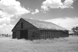 Figure 12.36. Barn at the Topaz Cattle Ranch. |
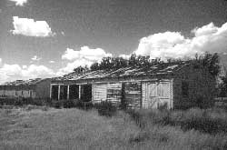 Figure 12.37. Garage at the Topaz Farm Kitchen. |
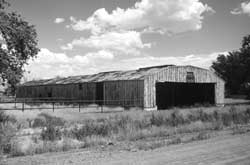 Figure 12.38. Barn at the Topaz Farm Kitchen. |
 Figure 12.39. Graffiti at the Topaz Farm Kitchen. |
 Figure 12.40. Graffiti at the Topaz Farm Kitchen. |
Interpretation
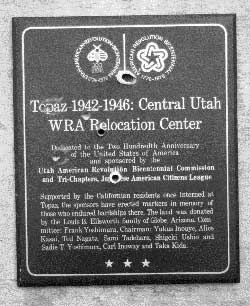 Figure 12.43. Detail of vandalized plaque. |
At the relocation center itself there is a large historic monument and a gravel parking area in what was the northwest portion of the central area. The area is within the former surplus equipment yard, according to WRA blueprints, and is presently part of Mr. Williams's holdings. The monument is a large concrete and rock-veneer block set on a concrete platform (Figure 12.42). Informative interpretative plaques set in the monument contain text describing the history of the relocation center and some historical photographs. Unfortunately, the monument has been vandalized by gunfire, and bullet holes have defaced the photographs (Figures 12.43 and 12.44).
Several barracks that had been sold to homesteading veterans are still in the surrounding vicinity. Some have been extensively remodeled into houses; those that were used as barns retain greater design integrity, but they are generally very deteriorated. In the town of Delta, there is a monument with directions to the relocation center site (Figure 12.45). In addition, the Great Basin Museum in Delta has an extensive display of photographs, artifacts, and other items related to the relocation center, as well as one-third of a barracks from Topaz restored to its original condition (Figure 12.46). Additional relocation center displays are located in the barracks.
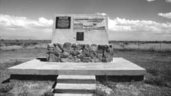 Figure 12.42. Monument at the site of the Topaz Relocation Center. |
 Figure 12.44. Detail of vandalized monument at the site of the Topaz Relocation Center. |
 Figure 12.45. Historical marker in Delta city park. |
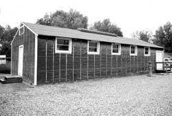 Figure 12.46. Restored partial barracks at the Great Basin Monument in Delta, Utah. |
| <<< Previous | <<< Contents>>> | Next >>> |
wacc/74/chap12.htm
Last Updated: 20-Feb-2004