|
National Park Service
Confinement and Ethnicity An Overview of World War II Japanese American Relocation Sites |

|
Chapter 13
Tule Lake Relocation Center
The Tule Lake Relocation Center is in Modoc County, California, 35 miles southeast of Klamath Falls, Oregon, and about 10 miles from the town of Tulelake. The town is spelled as one word and the relocation center as two. The post office designation for the relocation center was Newell, the name of the post office, general store, and gas station at a nearby crossroads.
The relocation center reserve, which encompassed 7,400 acres, is presently a mix of public, state, and private land (Figures 13.1 and 13.2). Situated in the Klamath Valley, the Tule Lake Relocation Center was located within an underdeveloped federal reclamation district, authorized in 1905. The Modoc Project was begun in the Klamath Reclamation District in 1920 to drain Tule Lake for use as farm land. By 1941, 3,500 acres of former lake bed were under cultivation (Jacoby 1996). Large remnants of Tule Lake, now a National Wildlife Refuge, lie within a few miles of the relocation center site.
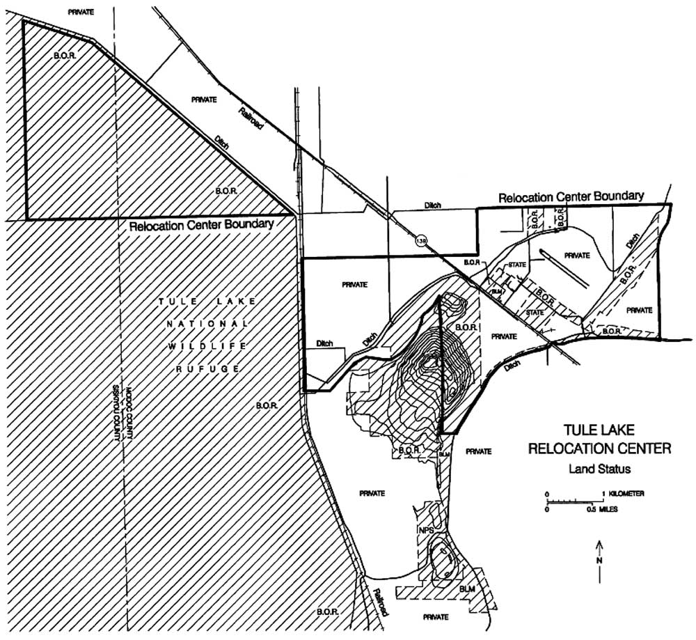
Figure 13.1. Land status, Tule Lake Relocation Center and vicinity.
(click image for larger size)
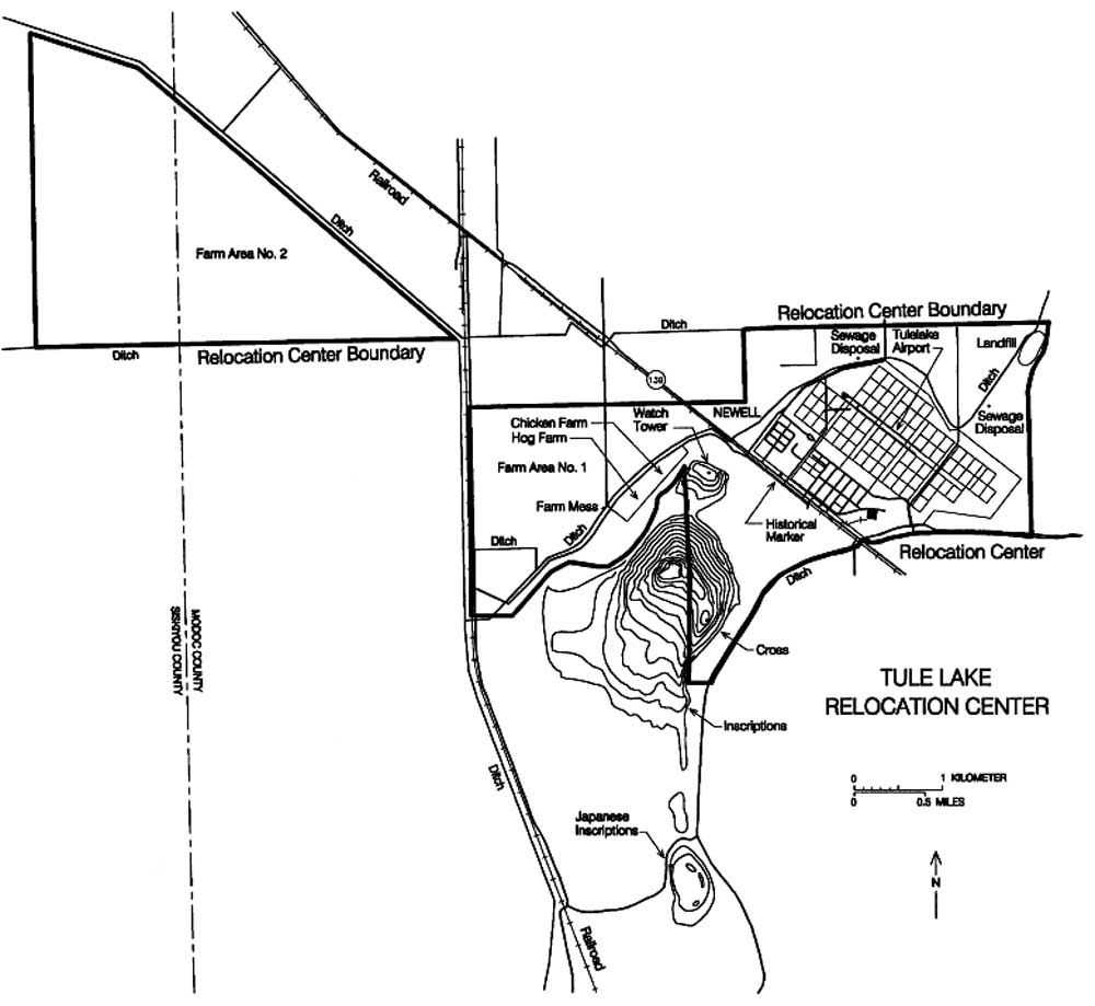
Figure 13.2. Tule Lake Relocation Center.
(click image for larger size)
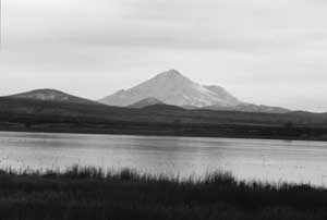 Figure 13.3. Tule Lake and Mt. Shasta. |
The lacustrine geology is evident: the relocation center site and surrounding area is flat and treeless, and the sandy loam soil is interspersed with the abundant remains of freshwater mollusks. To the south and west vulcanism is prominent: Tule Lake was just north of lava flows emanating from the Medicine Lake Highlands, the eastern-most promontory of the Cascade Range. An 800-foot-high bluff, called the Peninsula, is composed of volcanic tuff that was extruded within Pleistocene Tule Lake. The Peninsula lies just south of the developed central area of the relocation center, and there are other smaller bluffs to the north and east. Lava Beds National Monument includes two areas southwest of the relocation center, one just south of the Peninsula and another, much larger area at the northern end of the Medicine Lake Highlands. Fifty miles south on a clear day 14,000 foot Mt. Shasta is visible (Figure 13.3). At an elevation of 4,000 feet, the winters at Tule Lake are long and cold and the summers hot and dry. The vegetation consists of a sparse growth of grass, tules, and sagebrush.
Construction of the Tule Lake Relocation Center began April 15, 1942. On May 25, the first Japanese Americans, 500 volunteers from the Portland and Puyallup Assembly Centers, arrived to help set up the relocation center (Jacoby 1996). When the WRA later decided to send the evacuees at the Portland and Puyallup Assembly Centers to Minidoka rather than Tule Lake, some of these first volunteers decided to stay anyway since being the first to arrive they had good jobs. Most of the evacuees at Tule Lake were from the Marysville, Pinedale, Pomona, Sacramento, and Salinas Assembly Centers. In addition, a large number of evacuees were sent directly to the relocation center from the southern San Joaquin Valley without first going to an assembly center.
From the start, the Tule Lake Relocation Center was plagued by problems and discontent. Within 5 months of its opening there was a mess hall strike to protest inadequate food, a farm strike, and a general strike (Kowta 1976). Additional problems arose when, in response to public and congressional criticism, the WRA decided to segregate the "disloyals" from the "loyals" with a poorly-worded questionnaire. Those who answered "no" to the two loyalty questions were considered "disloyal."
When some 35 Nisei from the same block who had applied for repatriation to Japan failed to answer the questionnaire by an arbitrary deadline, the military police surrounded their block and arrested them. Over the next two months over 100 more evacuees were arrested and housed in nearby jails and an old Civilian Conservation Corps (CCC) camp 5 miles west of the relocation center (see Chapter 15). Measured by the questionnaire results, Tule Lake had the highest proportion of disloyals of all the Relocation Centers. While the average number of "no-no's" at other centers was 10 percent, at Tule Lake 42 percent did not answer the questionnaire at all, or answered no to both loyalty questions.
In the summer of 1943 the Tule Lake Relocation Center was converted into a maximum security segregation facility. One of the camps at Poston was originally chosen, but eventually, the disloyals were segregated to the relocation center at Tule Lake, which already housed the highest number of disloyals. The original evacuees at Tule Lake who answered "yes" to the loyalty questions were supposed to choose another relocation center to make room for more disloyals at Tule Lake. Some 6,000 evacuees did move out, but the 8,500 "old Tuleans" who remained included some 4,000 loyals who did not want to move yet again.
New barracks were constructed to house many of the new arrivals and Tule Lake became the largest of the WRA-run centers. By the spring of 1944, over 18,000 people were interned there (Figure 13.4). Additional troops were assigned to Tule Lake, including eight tanks (Drinnon 1987:110). A lighted 6-foot-high chain link "man-proof" fence, topped with barbed wire, as well as more watch towers were added around the relocation center perimeter. Fences and watch towers were also built around the outlying farm fields of the center.
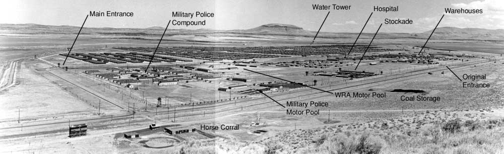
Figure 13.4. Tule Lake Relocation Center, 1946.
(Bureau of Reclamation, Sacramento, California)
(click image for larger size)
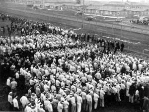 Figure 13.5. Demonstration at Tule Lake. (from Weglyn 1976) |
In October 1943 an evacuee farm worker died in a truck accident. To protest the minuscule compensation offered the victim's widow, agricultural workers went on strike. The administration brought in 234 Japanese Americans from other relocation centers to harvest the crops. For their protection, they were housed at the former CCC camp nearby. But the strikebreakers' presence and the fact they were paid about ten times the standard evacuee wage contributed to general discontent.
On November 1, a large crowd assembled in the administration area to protest the sending of center supplies to the strikebreakers. The military police used jeeps mounted with machine guns and tear gas to disperse the crowd and began the arrest of suspected leaders. Most work at the center stopped, and the evacuees boycotted a WRA-called assembly. On November 14 martial law was declared and the military police took over control of the center from the WRA. A fence and five watch towers were constructed between the administration and evacuee residential areas and a stockade was built to isolate those arrested from the rest of the center population (Figure 13.5 and 13.6).
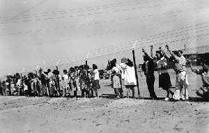 Figure 13.6. Fence between the administration and evacuee residential area. (Special Collections, J. Willard Marriott Library, University of Utah) |
Arrests and unrest continued until over 350 dissident leaders were in the stockade and 1,200 Issei had been sent to Department of Justice internment camps. On January 11 the remaining center residents voted to end the protest. In response to the vote, martial law was lifted on January 15 and the center administration, except for the stockade, was returned to the WRA. On May 23, 1944, control of the stockade was turned over to the WRA. However, tensions still ran high. On May 24, an evacuee was shot and killed during an altercation with a guard, and in June the general manager of the Business Enterprise Association, one of the most stable elements in the evacuee community, was found murdered.
Because many of the evacuees at Tule Lake had renounced their American citizenship, the Tule Lake Center operated until March 20, 1946. At that time the remaining 400 evacuees were transferred to the Crystal City Internment Center in Texas. Custodial administration of the center was transferred to the Bureau of Reclamation on May 5, 1946. The military police compound and one ward of the evacuee residential area were leased to the Tulelake Growers Association for migrant laborer housing (Figure 13.7). The first laborers arrived on May 27. The Growers Association also leased the three large industrial warehouses to store grain.
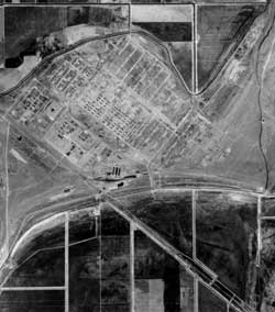 Figure 13.7. 1949 aerial photograph of the Tule Lake Relocation Center, north to the top. (Bureau of Reclamation, Klamath Falls, Oregon) |
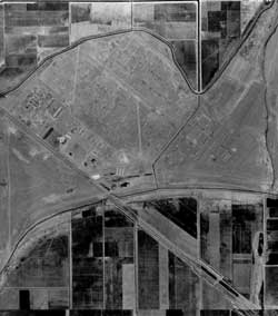 Figure 13.10. 1955 aerial photograph of the Tule Lake Relocation Center, north to top. (Bureau of Reclamation, Klamath Falls, Oregon) |
Some of the buildings and land of the center were distributed to veteran homesteaders and some land was kept by the Bureau of Reclamation. Other buildings were held for later transfer to homesteaders (570 barracks and other buildings), government agencies, and non-profit groups (school and service buildings and over 400 barracks). The remaining buildings were stripped of their furnishings and removed between July 28 and December 9, 1946 (Figures 13.8-13.10). Around 1963, H.A. and Anna Fletcher bought the military police compound and turned it into a subdivision. Many of the original buildings in the compound remain but have been modified, and some have been demolished.
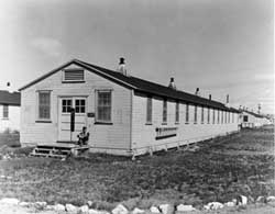 Figure 13.8. Abandoned staff building in the staff area, 1946. (Bureau of Reclamation, Sacramento, California) |
 Figure 13.9. Abandoned evacuee barracks, 1946. (Bureau of Reclamation, Sacramento, California) |
The construction and layout of the Tule Lake Center followed the WRA's general design for the relocation centers. The central developed area was adjacent to the Central Pacific Railroad and California State Highway 139 (Figure 13.11). The relocation center road grid was aligned with the highway, at about 50 degrees from true north. Roads parallel with the highway were designated 1st through 13th Street; roads perpendicular to the highway were designated 1st through 16th Avenue. Four roads west of 1st Avenue, the last constructed during the initial building of the relocation center, were named Modoc, Siskiyou, Klamath, and Shasta, since they did not fit in with the pre-existing numbering system. Later, for the segregation center, 17th, 18th, and 19th Avenues were added to the east (Figure 13.12).
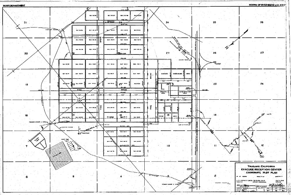
Figure 13.11. Tule Lake Relocation Center central area in 1942.
(Bureau of Reclamation, Klamath Falls, Oregon)
(click image for larger size)

Figure 13.12. Tule Lake Relocation Center central area in 1944.
(Bureau of Reclamation, Klamath Falls, Oregon)
(click image for larger size)
 Figure 13.13. Administration building at Tule Lake. (Francis Stewart photograph, Bancroft Library, University of California, Berkeley) |
From west to east along the south side of the central area was the military police compound (designated Block 1), the administration area and hospital (Block 2), and the warehouse and industrial areas (Block 3). The relocation center entrance was originally directly from the highway into the administration area, in the center of the central area. The administration area included four interconnected administration buildings (Figure 13.13), two other office buildings, a store, a mess hall, the director's residence, three staff houses, two dormitories, a laundry, nine recreation buildings, and three garages. Within the same block designation northeast of the administration area was the hospital. It included 19 buildings interconnected with covered walkways.
To the east of the administration area in the warehouse area there were 71 buildings. Many of these were warehouses, others included ten staff houses, three buildings used for an evacuee furniture factory, a bakery, and a tofu factory. During use of the center seven buildings from the warehouse area were moved to other areas. One was used for a funeral parlor, one for an office, one was split and used for the farm kitchen and a bunk house at one of the sewage treatment plants. Four were moved to the stockade when it was constructed.
East of the warehouse area was the industrial area, which included two railroad spurs, an office, ten warehouses, and a coal shed. Later, a latrine and three large buildings (60 feet by 300 feet) were added. One of the large buildings was a potato warehouse and the other two were to be used for factories, but were instead used for storage.
After Tule Lake was designated a segregation center a new, more secure entrance, a larger military police compound, a motor pool, and other facilities were built to the west of the original military police com-pound, which was converted to staff housing. As staff housing, the former military police compound included 27 staff houses, a dormitory, two latrines, two laundries, a warehouse, three garages, and an office. An elementary school for the children of the Caucasian staff was located in the open area between the staff housing and the highway. Older children of the Caucasian staff went to high school at the town of Tulelake. The relocation center post office was located at the north end of the staff block to allow access from both sides of the security fence built between the administration area and the evacuee housing.
The new WRA motor pool area, constructed between the staff housing and the new military police compound, included two offices, two repair shops, a gas station, a latrine, a wash rack, two grease racks, a storage shed, and a vehicle shed.
The new military police compound, in the west corner of the central area, housed an entire battalion (31 officers and 900 enlisted men; eventually 1,200 soldiers would be assigned to Tule Lake). The compound included a headquarters building, a military jail, a theater/ chapel, a post exchange, a fire station, two classroom buildings, three officers' quarters, an officers' mess hall, an officers' recreation building, 22 enlisted men's barracks, two enlisted men's mess halls, four enlisted men's recreation buildings, five supply rooms, a warehouse, a cold storage building, an ordnance building, and a substation and auxiliary power supply. To the south, the military police motor pool included a gas station, two latrines, a wash rack, a grease rack, two sheds, a motor repair shop, an office, a warehouse, a utility building, and a carpenter and paint shop.
The new entrance to the center was along the northwestern fence between the evacuee area and the new military police compound. Access from the highway was via a road along the outside of the fence. At the new entrance was a vehicle gate, a sentry post, and two pedestrian turnstiles (one on each side of the road). From the gate the road entered the central area and continued east 1,600 feet through a large open area between two security fences to another gate. This inner gate was the farm workers' embarkation area, where there was another sentry post and multiple turnstiles for pedestrians, with gates on either side for vehicles (Figure 13.14), a processing building to one side, and a parcel inspection building on the other.
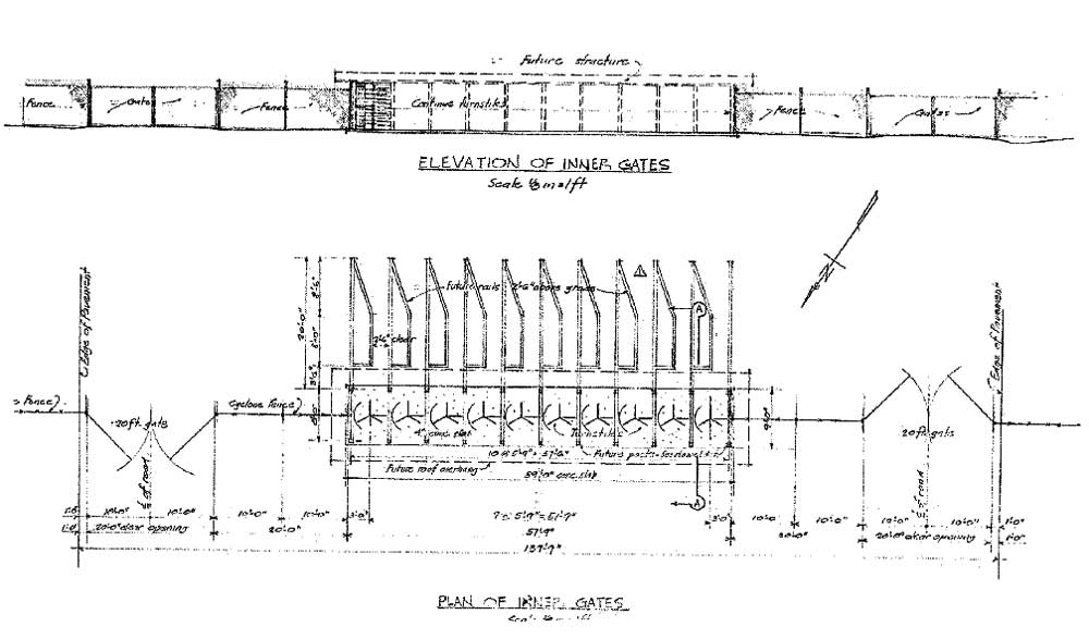
Figure 13.14. Detail of inner gate at Tule Lake.
(National Archives)
(click image for larger size)
There were other gates along the perimeter security fence, some with sentry posts (gate houses): one to each of the two sewage treatment plants, the old main gate, two at the railroad spur, and one from the highway to the military police area. There were also four gates along the fence constructed between the administration and the evacuee residential areas.
Unique features of the Tule Lake center were the stockade, a 250-foot-by-350-foot area enclosed by fences and watch towers, and a jail located to the north of the stockade. The stockade watch towers included one original perimeter tower and three others moved from outlying farm areas. The side of the stockade towards the evacuee housing area was paneled to inhibit communication between those within and outside the stockade. Within the stockade fence there were two to five barracks, a mess hall, and a latrine (Drinnon 1987:111).
Around the perimeter of the relocation center there were originally only six watch towers, but after Tule Lake was converted to a segregation center, there was a total of 19 towers on the perimeter. The newly-constructed towers were of a slightly different design (Figure 13.15). In addition to the lighted 6-foot-high perimeter fence topped with barbed wire, there was a warning fence 50 feet in from the perimeter fence (Figures 13.16 and 13.17). A WRA blueprint depicts the warning fence as about 3-1/2 feet high, constructed of wood posts with wood rails, barbed wire, and warning signs.
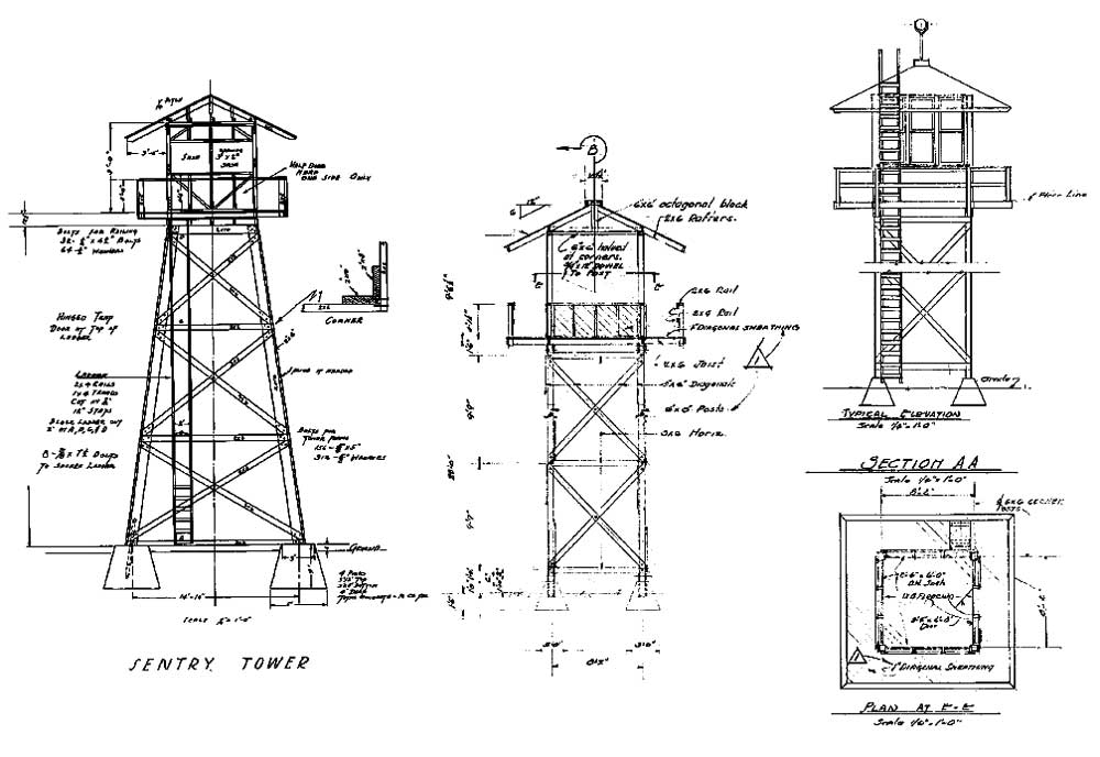
Figure 13.15. Watch tower designs at Tule Lake, left 1942, middle and right 1943.
(National Archives)
(click image for larger size)

Figure 13.16. Details of the perimeter road and security fences at Tule Lake.
(National Archives)
(click image for larger size)
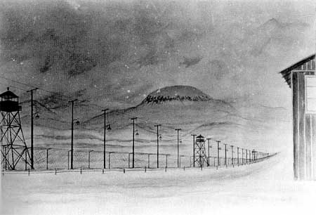 Figure 13.17. Evacuee painting of the lighted perimeter fence at Tule Lake. (Drinnon 1987:95) |
The evacuee residential blocks were located on the northeast side of the central area away from the highway. The evacuee area was separated from the rest of the developed central area by a 400-foot-wide firebreak. The fence that was added between the evacuee residences and the administration areas after the Fall 1943 disturbance was constructed along the south side of the firebreak.
The evacuee residential blocks were divided into eight wards, each bounded on all sides by 200-foot-wide firebreaks. Most wards comprised nine evacuee residential blocks; the exceptions were Ward 6, which had only six blocks, and Ward 8, on the east side, which was composed of 13 blocks. The eastern portion of the evacuee residential area was crossed by a canal.
The 40 earliest-constructed evacuee residential blocks each had thirteen 20-foot-by-100-foot barracks (Figure 13.18), a mess hall, a recreation building, a men's latrine and shower, a women's latrine and shower, a laundry, and an ironing room. Later, another women's latrine and shower building was added to each of these blocks. Sixteen later-constructed blocks had a combination men's and women's latrine and shower building and a combination laundry and ironing room. After segregation ten more of these types of blocks were added, for a total of 66 residential blocks. Blocks were numbered sequentially, likely in the order they were built, but with numbers 55 and 60-65 not used.
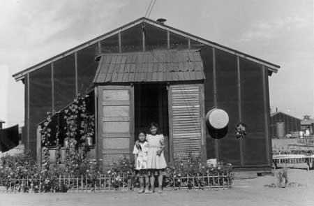 Figure 13.18. Evacuee barracks at Tule Lake. (John D. Cook photograph, Bancroft Library, University of California, Berkeley) |
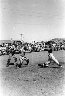 Figure 13.19. Baseball game at Tule Lake. (Special Collections, J. Willard Marriott Library, University of Utah) |
Block recreation buildings were used for offices, six stores, five canteens, a beauty parlor, a barber shop, four judo halls, eight Buddhist churches, a Catholic church, and three other churches. In the firebreaks there were three fire stations, a fish store, an outdoor stage (Tulean Dispatch 4/6/43), and a funeral parlor and cemetery, as well as 31 baseball and softball fields (Tulean Dispatch 5/11/43; Figure 13.19), and a sumo wrestling pit between blocks 18 and 19 (Tulean Dispatch 7/2/43).
New school buildings were planned, but only the high school, located in the firebreak between the hospital and evacuee residential area, was ever completed and then not until February 1944. It included an auditorium/gym, a shop, a science and crafts building, a library, an administration building, and four classroom buildings, connected by covered walks. Two of the classroom buildings at the high school were used for an elementary school.
Domestic water was supplied by seven wells, a water treatment plant, and an elevated 200,000 gallon storage tank to the east of the central area, and two 1 million gallon tanks to the south on the Peninsula. Sewage was treated in two plants, the second added after the relocation center was changed to a segregation center and expanded. Each had a sump pump, Imhoff tank, sludge beds (180 feet by 366 feet), and effluent beds (800 feet by 900 feet). Apparently the first plant did not have enough capacity even for the original relocation center population: WRA blueprints show a large pond for holding untreated sewage near it.
There were two farm areas, Farm Area 1 southwest and north of the central area, and Farm Area 2 three miles west of the central area (Figures 13.20-13.24). After segregation each farm was surrounded by a warning fence, a security fence, and 16 watch towers. Farm Area 1, nearest the central area, also had five searchlights. A WRA blueprint notes that large boulders at the base of an adjacent bluff were removed, probably to eliminate cover for possible escapes. A watch tower shown as on WRA blueprints on the Peninsula overlooking Farm Area 1 and the central area was likely a CCC-built fire lookout. After the disturbance in the Fall of 1943, eight of the watch towers at Farm Area 2 were moved to the central area. Five were placed along the fence constructed between the evacuee barracks and the administration area, and three were placed at the stockade.
Figure 13.20. Outlying farm areas at Tule Lake.
(National Archives)
(click image for larger size)
In 1942, 450 evacuee laborers farmed 837 acres of barley, 570 acres of potatoes, 208 acres of onions, 145 acres of carrots, 152 acres of rutabagas, and other vegetables. The next year, 813 acres in Farm Area 1 west of the relocation center were planted with oats, rye, barley, alfalfa, clover, and mixed vegetables, and 455 acres north of the central area were planted in oats, rye, and alfalfa. In Farm Area 2, over 2,300 acres were planted with barley, mixed vegetables, and potatoes (Tulean Dispatch 6/18/43).
To bring Farm Area 2 under cultivation the evacuees had to build a distribution and drainage system which included 13 miles of canals, 8.5 miles of drains, 180 timber gates and other structures, and two small drainage pumping plants (Hayden 1943). In 1945 the evacuees lined 2,920 feet of canal ("M" Canal) through the relocation center, and began construction of a timber bridge with concrete piers, but work was suspended due to lack of labor as evacuees were released (Bureau of Reclamation 1946).
Farm Area 1 also included a farm kitchen and the hog and chicken farms near the base of the Peninsula (Figures 13.25-13.27). At the chicken farm there were 20 coops, granaries, an office, and a processing plant. The hog farm had 26 hog pens, a slaughter house, a well, and a water tank. The farm kitchen was located across the road from the hog farm. Across the highway south of the central area were a horse corral, a coal unloading and storage area (Figure 13.28), water wells, and two water tanks.

Figure 13.27. Hog and chicken farms at Tule Lake.
(National Archives)
(click image for larger size (~82K) )
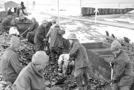
Figure 13.28. Unloading coal at Tule Lake.
(Francis Stewart photograph, Bancroft Library, University of California, Berkeley)
 Figure 13.21. Irrigating crops at Tule Lake. (Francis Stewart photograph, Bancroft Library, University of California, Berkeley) |
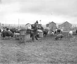 Figure 13.25. Hog farm at Tule Lake. (Francis Stewart photograph, Bancroft Library, University of California, Berkeley) |
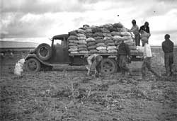 Figure 13.23. Loading potatoes. (Francis Stewart photograph, Bancroft Library, University of California, Berkeley) |
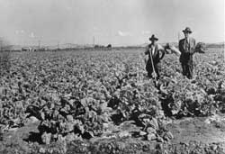 Figure 13.24. Field of Chinese cabbage. (Bureau of Reclamation, Sacramento, California) |
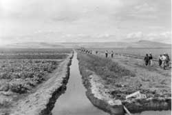 Figure 13.22. Irrigation ditch at Tule Lake. (Francis Stewart photograph, Bancroft Library, University of California, Berkeley) |
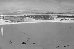 Figure 13.26. Chicken farm at Tule Lake. (Francis Stewart photograph, Bancroft Library, University of California, Berkeley) |
Central Fenced Area
 Figure 13.29. Overview of the central area of the Tule Lake Relocation Center today. |
Along State Highway 139 within the former central area of the relocation center is the present town of Newell. Within the town many buildings from the relocation center remain at their original locations. While most have been extensively remodeled, some appear relatively unchanged. The greatest number of extant buildings is in the military police compound (see Security Features, below).
Outside of the area along the highway nearly all of the central area has been graded to some extent, with most of the concrete slabs either removed or broken up and piled. Some areas are farmed but most of the vicinity is open space apparently used for cattle grazing (Figures 13.29 and 13.30).
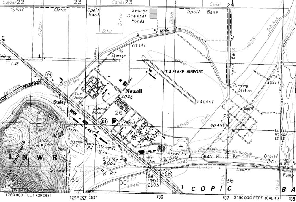
Figure 13.30. Central area at the Tule Lake Relocation Center today.
(adapted from USGS 7.5' maps Newell and Tulelake, California, 1988)
(click image for larger size (~125K) )
Central Fenced Area
Administration, Hospital Area, Staff Housing, and Motor Pool
Areas
Outside the evacuee housing area, most of the relocation center road grid is still in place. The present Newell general store was the staff personnel recreation building. The building, with decorative wood floors and an impressive evacuee-built rock fireplace, is relatively unchanged (Figure 13.31). Another building behind the store dates to the relocation center, but these historic buildings are nearly surrounded by more recent houses. None of the other administration or hospital buildings remain.
No relocation center buildings remains in the staff housing area — the location is now the site of a small housing project and a high school. A Caltrans maintenance facility encompasses the relocation center motor pool, and three relocation center buildings are still in use, along with more modern additions.
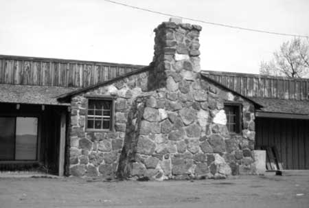
Figure 13.31. Basalt rock chimney at the Newell store.
Central Fenced Area
Warehouse and Industrial Area
Among numerous more recent buildings, three relocation center buildings remain in the warehouse area. There are Japanese inscriptions in pencil on the interior wall of one of the buildings, now privately owned and used as a shop. The writing, some of which is faded, is entirely in phonetic Japanese. The consistent handwriting suggests that one person wrote the entire text, but the lack of organization suggests the writer did not have later readers in mind (Table 13.1; Figure 13.32).
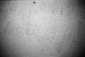
Figure 13.32. Portion of pencilled Japanese text on the wall
of a former relocation center warehouse.
(photograph courtesy of Lava Beds National Monument)
Table 13.1. Translation of Japanese Text on the Interior Wall
of a Former Warehouse at the Tule Lake Relocation Center.
|
The world is not governed fairly. Takahiro (?) Ikeda is a right-winger, is a whit fig. The imitations in ... Kill them (us). Japanized Japanese. Not a land of God, nor of Buddha, nor of the stars. Ever since Hojo came in, Tokugawa and Shimazu rule ... Duke of Simazu. Maeda ... Tokisada Hojo's blood ... God does not live in today's world. Blue. Red. Blue (young) county. Not an Asian. Russia (?) that invaded Japan ... /People of Kagoshima prefecture /People of Nagasaki prefecture /Gandhi of India is ... /Hojo Takashi (?) ... Sumire (?) Tokugawa /from Nikolaevsk. (Hojo, Tokugawa, Shimazu, Maeda, and Ikeda are sur names. The Hojo was a clan which ruled Japan during the late Kamakura period. Simazu, Maeda, and Ikeda were famous lords in the feudal Tokugawa (Edo) period. It is likely that those names are symbolically used to mean something or someone else.) |
|
Japan, the country under the sun. America, the country of stars. Longing for the stars. America. Asia. Usami Hachimangu (a shrine's name). |
Within the former industrial area, five relocation center buildings are currently being used by the Newell Potato Cooperative. These include the three large industrial warehouses and two smaller warehouses; all have some modification, including the addition of metal roofs and siding (Figure 13.33). Northeast of the industrial area there is a large borrow pit.

Figure 13.33. Former industrial warehouses at the
Tule Lake Relocation Center.
Central Fenced Area
Evacuee Residential Area
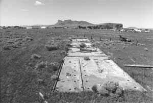 Figure 13.34. Concrete slab foundation of combination men's and women's latrine and shower building in Ward 7. |
In the evacuee residential area, all of the relocation center roads west of the "M" Canal have been obliterated. Most of the evacuee residential area is taken up by the Tule Lake Airport. The vicinity is irrigated and used for grazing and cultivated fields. One area now has a transfer station for recycling waste.
Along a post-relocation center road in the western end of the central area the foundation slabs of some of the communal buildings within two blocks of Ward 7 remain. The size and layout of two of the slabs indicate they were the combined men's and women's latrine and shower building; one of the slabs has been damaged by the new road (Figures 13.34-13.37). Other slabs remain from laundry buildings, and concrete bins for the storage of heating coal are still present (Figure 13.38). Nearby, in a field south of an access road to the airport, there is a segment of basalt and concrete-lined ditch and a culvert from a relocation center road (Figure 13.39).
There are few artifacts in the cleared irrigated areas; these include small intact bottles, jar fragments with 1940s date marks, other glass fragments, a few hotel ware ceramic fragments, abundant coal, lumber fragments, drywall fragments, concrete debris, stove pipe, and animal bone fragments. At the relocation center high school site there are manholes and numerous foundation blocks (Figure 13.40), apparently little disturbed in spite of grazing and other activities in the vicinity.
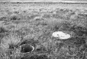 Figure 13.44. Manhole in Ward 8. |
Blocks built to the east of the original evacuee housing when Tule Lake was converted to a segregation center (Ward 8) have not been farmed or irrigated, and the road grid is still marked by red cinder roads (Figure 13.41). Slabs and rubble at latrine locations (Figure 13.42), a standing metal clothesline pole (Figure 13.43), and manholes remain, as well as scattered artifacts from the relocation center use.
 Figure 13.35. Concrete slab foundation of combination men's and women's latrine and shower building in Ward 7. |
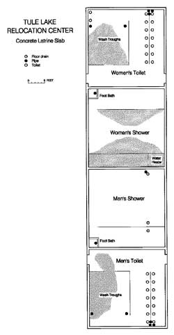 Figure 13.37. Sketch map of combination men's and women's latrine and shower building in Ward 7. (stippling denotes dirt-covered portion of slab) |
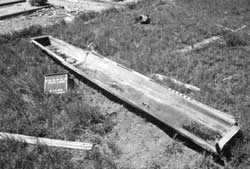 Figure 13.36. Metal trough urinal discarded next to men's latrine foundation. | |
 Figure 13.38. Heating coal storage bin in Ward 7. |
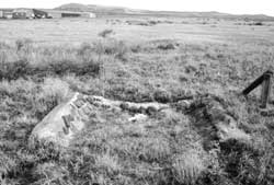 Figure 13.39. Rock and concrete culvert near the present-day Tule Lake Airport. |
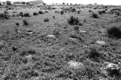 Figure 13.40. Concrete footing blocks at the site of the Tule Lake Relocation Center high school. |
 Figure 13.41. Typical relocation center road in Ward 8. |
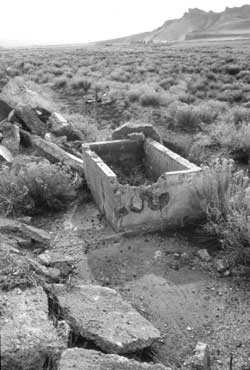 Figure 13.42. Concrete slab and rubble in Ward 8. |
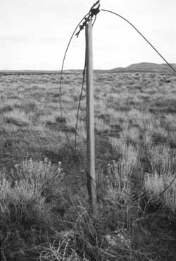 Figure 13.43. Clothesline pole in Ward 8. |
Security Features
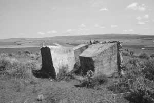 Figure 13.45. Watch tower foundation blocks at Tule Lake. |
Around the edge of the central area there are pulled foundation blocks of a few of the large watch towers built in 1942 (Figures 13.45 and 13.46). No intact watch tower foundations are present around the central area. However, at least one intact 1943 watch tower foundation is present at the hog farm (see Outlying Areas below). The perimeter patrol road on the north and east sides of the central area is still used. Also along the northern perimeter is one of the most poignant features at the site: standing sections of the six-foot- high "man-proof" fence of chain link and barbed wire (Figures 13.47-13.48). The entrance road on the east end of the central area is still in use, and the concrete foundation slabs of the inner and outer sentry buildings and remnants of rock work near the outer sentry post are still present (Figures 13.49-13.51).
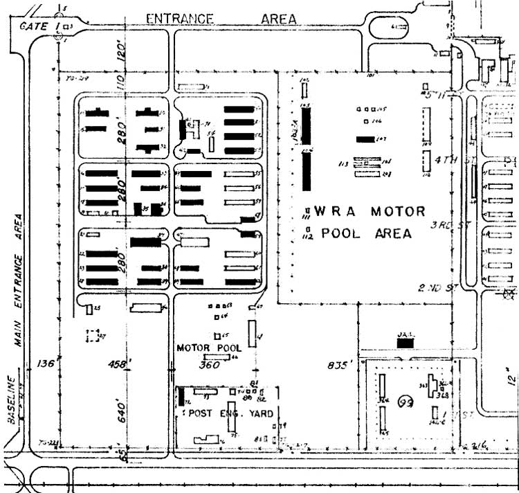 Figure 13.54. World War II-era buildings remaining in the military police compound. (click image for larger size) |
Thirty-three World War II-era buildings in the military police compound are currently used for homes or outbuildings (Figures 13.52-13.54). Many of the buildings have been modified, but others apparently have had very little work done on them since the 1940s. The original functions of these houses and outbuildings include 13 barracks, five recreation buildings, three officers' quarters, three supply buildings, two mess halls, two classroom buildings, half of the administration building, the cold storage building, the fire station, and the post exchange (Figures 13.55-13.60). There is a concrete slab foundation at the theater/chapel location and one additional standing building to the south in the military police motor pool area. The original paved roads of the military police compound are all still used.
East of the military police compound the jail still stands, abandoned. The jail, within a Caltrans maintenance yard and surrounded by a fence with a locked gate, was documented in 1989 by the Historic American Building Survey (HABS Number CA-2279). No remains of the adjacent stockade are apparent.
The one-story concrete jail is made of steel-reinforced concrete walls and a similar flat concrete roof (Figures 13.61 and 13.62). There are six identical cells in the building, four against the northwest wall and two against the southeast wall. Each cell had six bunks, a toilet and a wash basin (Figure 13.63). There is no evidence of electricity in each cell, but the building was wired. Apparently a single cast-iron coal burning stove in the entrance room heated the entire building (Figure 13.64).
There are numerous pencilled inscriptions on the jail cell walls. Many are simply doodles, but others include names, dates, and political statements. Some are in Japanese and some are in English (Table 13.2; Figures 13.65-13.66, cover art). It is apparent that in some cases the writer was lying on his bunk since the writing is 90 degrees from the horizontal.
Table 13.2. Selected Pencilled Inscriptions on the Walls of the Stockade Jail.
| Japanese | "The Great Japanese Empire" (dai nippon teikoku) and the word "window" | Figure 13.65 | ||||||||||||||||
| Japanese | "Down with the United States" | cover art | ||||||||||||||||
| Japanese | "Yoshida" (surname) | |||||||||||||||||
| Japanese | Three times the ideogram for "tadashii;" this is a Japanese/Chinese, way of counting off, as Americans use 1111 and then a diagonal line; the character has five strokes, so a complete character (all of these are complete) counts off "5" | |||||||||||||||||
| Japanese | Right portion of left set reads: "Kaishaku wo tanomu,
meaning "Please he a second when I commit Harakiri." Left portion of left set reads: "Mondai no kaishaku," meaning "Interpretation of problem." Both portions use the word "kaishaku," though they have different meanings. A Chinese translator translated the right portion as "Today was wrongfully accused of disorder problem" and the left portion as "The explanation of the problem." Upper right character not clearly written but seems to be the male first name Akira; other characters in that set are illegible. |
cover art | ||||||||||||||||
| Japanese | Left column: (indistinct) Yamaguchi Terasu (a male
name, Terasu Yamaguchi) Iwakuni City (in Japan), the last character is
"vehicle" which does not seem to fit, or if badly written, "east") Middle column: Kono (or Kawano) Toshisen (a male name, Toshisen Kono or Kawano) 1919 (one more character, illegible) Right column: September 29, 1945 |
Figure 13.66 | ||||||||||||||||
| Japanese | Graffiti with parts of names and words in hiragana (one of the Japanese phonetic systems); legible characters include "center," "loyalty," and "useful lecture" (story, information) | |||||||||||||||||
| English | When the golden sun has sunk beyound the desert horizon and darkness followed, under a dim light casting my lonesome heart | |||||||||||||||||
| English | Show me the way to go to home | cover art | ||||||||||||||||
| English | Large "5" | |||||||||||||||||
| English |
|
|||||||||||||||||
| English | H.T. 5/25/45 MON. |
cover art |
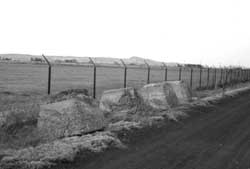 Figure 13.46. Watch tower foundation blocks and perimeter fence at Tule Lake. |
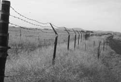 Figure 13.47. Perimeter fence at Tule Lake. |
 Figure 13.48. Perimeter fence at Tule Lake. |
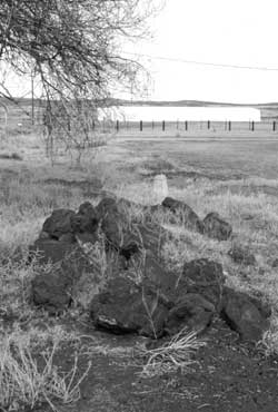 Figure 13.50. Rock work near outer sentry post. |
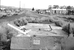 Figure 13.49. Outer sentry post foundation. |
 Figure 13.51. Inner sentry post foundation. |
 Figure 13.52. Overview of military police compound, 1946. (Bureau of Reclamation, Sacramento, California) |
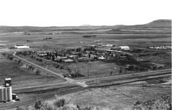 Figure 13.53. Overview of military police compound today. |
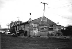 Figure 13.55. Building in MP compound. |
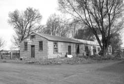 Figure 13.56. Building in MP compound. |
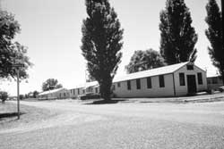 Figure 13.57. Building in MP compound. |
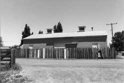 Figure 13.58. Former MP fire station. |
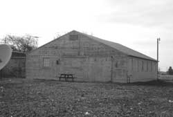 Figure 13.59. Building in MP compound. |
 Figure 13.60. Building in MP compound. |
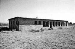 Figure 13.61. Stockade jail at Tule Lake. |
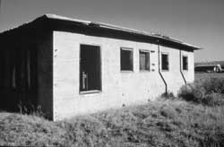 Figure 13.62. Stockade jail at Tule Lake. |
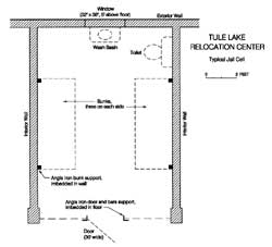 Figure 13.63. Typical jail cell. |
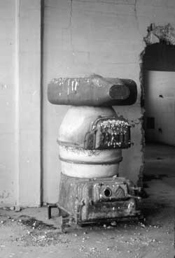 Figure 13.64. Heating stove in the stockage jail. |
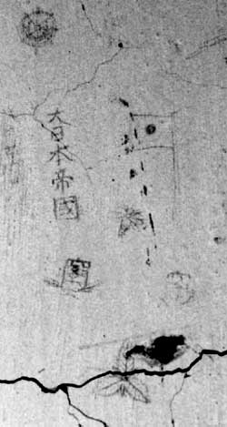 Figure 13.65. Japanese graffiti on the wall of the stockade jail. |
 Figure 13.66. Japanese graffiti on the wall of the stockade jail. |
Outlying Areas
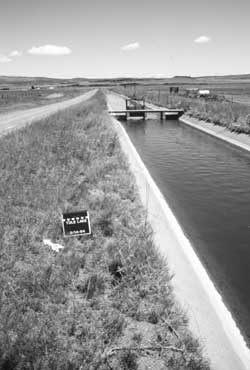 Figure 13.67. M Canal today. |
Many of the outlying features of the relocation center are still evident, including farm fields, irrigation and drainage ditches, the farm kitchen, hog farm, chicken farm, horse corral, landfill, sewage treatment plants, and other features. There are evacuee inscriptions in concrete at the hog farm and in rock at two petroglyph sites.
Farm Fields and Ditches
Around the perimeter and within the central area there are two large concrete-lined irrigation canals, at least one of which ("M" Canal) was lined by the evacuees (Figure 13.67). Other outlying ditches constructed or used by the relocation center are still in use as well. The portion of Farm Area 1 east of the central area is private land still under cultivation; the part of Farm Area 1 north of the central area is apparently used for grazing. Farm Area 2, west of the central area, is now part of the Tule Lake National Wildlife Refuge.
The farm kitchen located within Farm Area 1 is still standing, but abandoned. The building is pretty well overgrown by trees, bushes, and other vegetation (Figure 13.68). Irregular in shape, it appears to be a combination of at least two buildings salvaged and reconstructed at the site. It has a partial concrete slab, an interior bathroom, and an interior door that reads "diet kitchen" (Figure 13.69).
 Figure 13.68. Tule Lake Relocation Center farm kitchen today. |
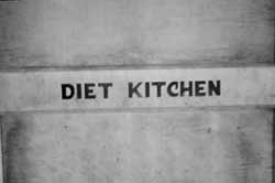 Figure 13.69. Detail of interior door at the Tule Lake Relocation Center farm kitchen. |
Hog and Chicken Farms
The site of the hog and chicken farms is now within the Tule Lake Wildlife Refuge, which limits access during the nesting season. From the Peninsula overlooking the hog and chicken farms, distinctive patterns in the grass are easily visible showing the outlines of former buildings, fences, and roads (Figures 13.70 and 13.71). Most notable is the red cinder road that was once around the perimeter. There are intact manholes at the hog farm, and at the southern end of the hog farm there are the concrete foundations of the slaughterhouse, other structures, and a watch tower (Figures 13.72-13.77). There is also a dilapidated well house (Figure 13.78), with inscriptions in its 5-foot-by-5-foot concrete floor (Table 13.3, Figures 13.79 and 13.80).
Table 13.3. Inscriptions at the Tule Lake Hog Farm (all in English).
|
1943 Charles Kodowaki Pre-Segregation |
Figures 13.79 and 13.80 |
|
TULE LAKE WATER WAGON 200-06 |
Figure 13.80 |
|
George Ohano 8/12/43 |
Figure 13.80 |
|
Ted Ohi 8/12/43 |
Figure 13.80 |
|
Aki Hamasaki 8/12/43 |
Figure 13.80 |
Horse corral
At the horse corral location, across Highway 139 from the central area, there are two badly weathered concrete slabs (Figure 13.81) and several concrete bases with imbedded metal straps which supported the roof columns of the stable. At the southwest end of the corral there are several half-buried, in-line creosoted poles apparently delineating that edge of the corral, surrounded by red cinder gravel used for a road. There are more red cinders at the forage shed location (Figure 13.82).
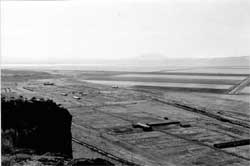 Figure 13.70. Hog and chicken farms in 1943. (National Archives) |
 Figure 13.71. Overview of hog and chicken farm areas today. |
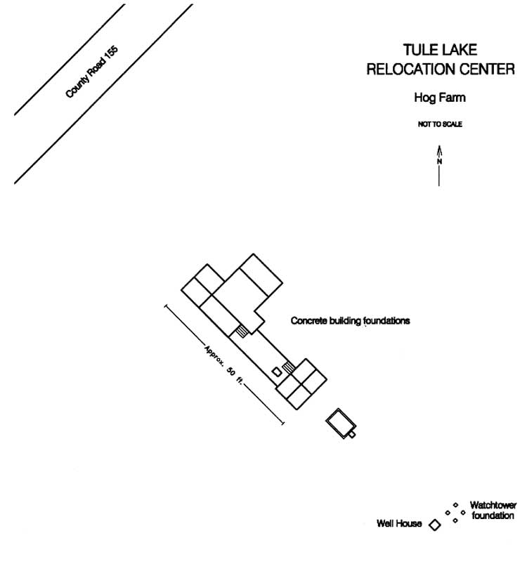 Figure 13.72. Foundation remains at the southern end of the Tule Lake Relocation Center hog farm. (click image for larger size (~24K) ) |
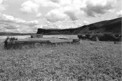 Figure 13.73. Foundation remains at the southern end of the Tule Lake Relocation Center hog farm. |
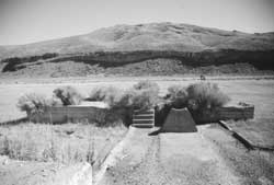 Figure 13.74. Foundation remains at the southern end of the Tule Lake Relocation Center hog farm. |
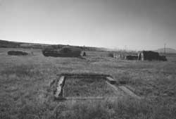 Figure 13.75. Foundation remains at the southern end of the Tule Lake Relocation Center hog farm. |
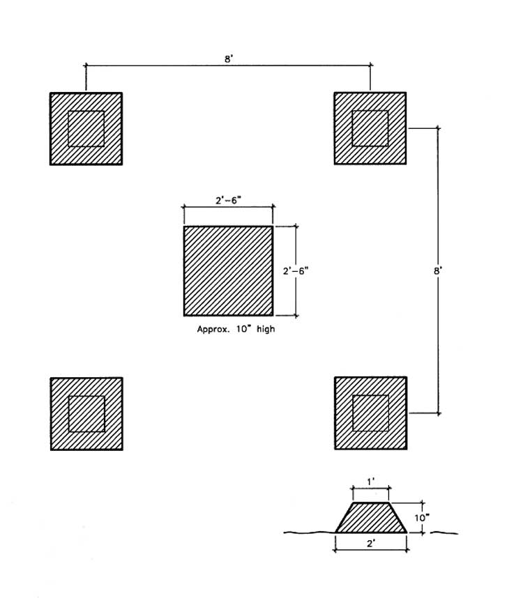 Figure 13.76. Watch tower foundation at the Tule Lake Relocation Center hog farm. (click image for larger size (~39K) ) |
 Figure 13.78. Well house at the Tule Lake Relocation Center hog farm. |
 Figure 13.77. Watch tower foundation at the Tule Lake Relocation Center hog farm. |
 Figure 13.79. Inscription at well house. |
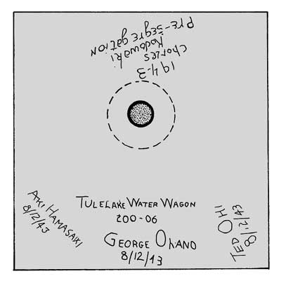 Figure 13.80. Inscriptions in the concrete slab floor of the hog farm well house. | |
Outlying Areas
Horse corral
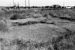 Figure 13.81. Concrete slabs at the horse corral location. |
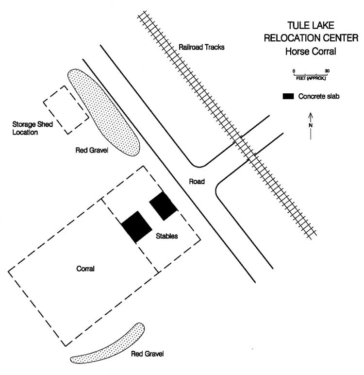 Figure 13.82. Sketch map of the Tule Lake Relocation Center horse corral. (click image for larger size (~44K) ) |
Outlying Areas
Sewage Treatment Plants and Landfill
Both sewage treatment plants contain the remains of the large multi-chambered concrete Imhoff tanks, measuring approximately 54-1/2 feet by 63 feet by 21 feet high (Figures 13.83 and 13.84). The sludge bed location at Plant No. 2 is indicated by a low berm. Plant No. 1, north of the central area, is owned by the Newell County Water District. Plant No. 2 is located east of the central area.
 Figure 13.83. Imhoff tank at Sewage Treatment Plant No. 1. |
 Figure 13.84. Imhoff tank at Sewage Treatment Plant No. 2. |
The relocation center landfill is on Bureau of Reclamation land northeast of Sewage Treatment Plant No. 2. It includes at least six parallel trenches with abundant burned and unburned trash (Figures 13.85-13.87). A wide variety and large number of artifacts include large cow bones, abundant glass fragments (food jars, "Coke" bottle fragments from Pittsburg, CA, Bend, OR, and Klamath Falls, OR, and "Mt. Lassen Soda"); hotel ware ceramics fragments (with "Bauer," "Hall," "tepco," "usqmc," and "V" basemarks), and some Japanese ceramics (Figures 13.88 and 13.89). Northeast of the trenches, a dense concentration of hotel ware ceramic fragments likely marks a disposal pit (Figures 13.90 and 13.91).
The landfill and surrounding area includes abundant post 1940s trash; for example, bottle dates at the landfill range from 1942 to 1952. More post 1950s trash has been dumped and scattered throughout the area to the south and east of the landfill. There are also many concrete chunks to the south, perhaps from relocation center building slabs, in rocky areas not suitable for farming.
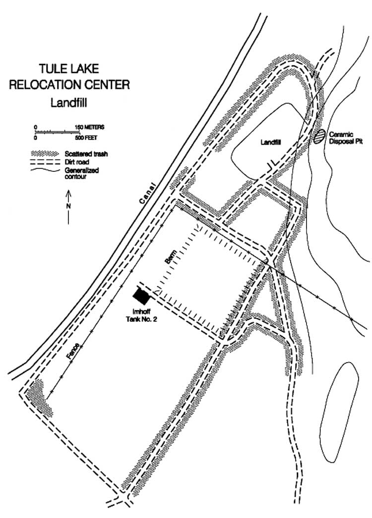
Figure 13.85. Sketch map of the relocation center landfill vicinity.
(click image for larger size (~78K) )
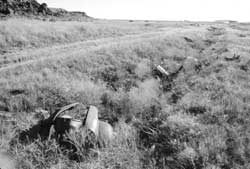 Figure 13.86. Trash-filled trench at the Tule Lake Relocation Center landfill. |
 Figure 13.87. Trash-filled trench at the Tule Lake Relocation Center landfill. |
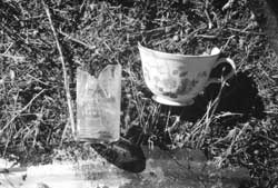 Figure 13.88. Typical artifacts at the Tule Lake Relocation Center landfill. |
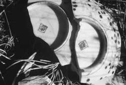 Figure 13.89. Typical artifacts at the Tule Lake Relocation Center landfill. |
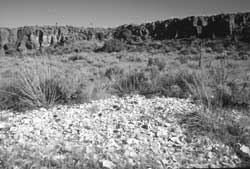 Figure 13.90. Ceramic disposal at the Tule Lake Relocation Center landfill. |
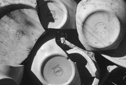 Figure 13.91. Detail of the ceramic disposal area. |
Outlying Areas
Inscriptions
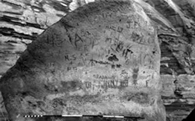
There are two areas south of the developed central area that have carved Japanese-American inscriptions. One area, recorded as site CA-MOD-22, is 2 miles south of the central area on an east-facing cliff of the Peninsula (Figure 13.92). The site was originally recorded for a proposed land exchange, and is now BLM land (Gates 1982). Most of the glyphs at CA-MOD- 22 are prehistoric, but there are many historic inscriptions. The World War II-era inscriptions are within a 100 foot-long area, 5 to 10 feet above the ground. They include Japanese American names, 1942 and 1943 dates, a possible relocation center address, and one glyph reading "Tule Lake WRA Center," (Table 13.4; Figures 13.93 and 13.94). One name looks like it was done with a rotary grinder or similar tool, because the edges are smooth and deep.
Table 13.4. World War II-era Inscriptions at Rock Art Site CA-MOD-22 (all in English).
|
KUROSAWA 1/10/43 |
Figure 13.93 |
|
OKI RP TULE LAKE WRA CENTER 3/31/43 |
Figure 13.94 |
| E... MATSHI... | Figure 13.94 |
|
42 I.S. Nishimito O. ...ona |
Figure 13.94 |
| MASAU M. | Figure 13.94 |
| JACK T | Figure 13.94 |
|
TANKA 9-26-01 |
Figure 13.94 |
The other area with Japanese American inscriptions is at Petroglyph Point (site CA-MOD-1), about 3-1/2 miles south of the central area within a detached portion of Lava Beds National Monument. There are many thousands of glyphs from prehistoric through contemporary on the cliff faces (Figure 13.95). All of the prehistoric glyphs at the site were recorded in 1988 (Lee et al. 1988).
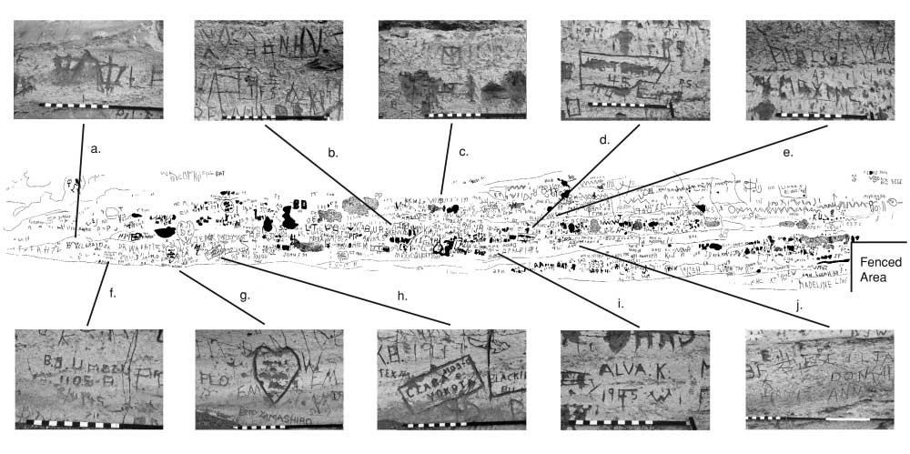
Figure 13.96. Selected World War II-era inscriptions on the cliff face at Petroglyph Point.
(click image for larger size (~78K) )
The main petroglyph area has been fenced since before the relocation center's establishment. To the north of the fenced cliff face there are some prehistoric glyphs and hundreds of modern and historic inscriptions in an area about 75 feet long. Most of the World War II-era inscriptions are located in this area, which corresponds to Panels 29 through 32 in the 1988 recording. The cliff face is so crowed with graffiti and over-writing that many individual inscriptions are difficult to read. But identifiable are a few Japanese characters, Japanese American names, 1940s dates, and relocation center addresses (Table 13.5, Figure 13.96). Some appear to have been deliberately erased.
Table 13.5. Selected Inscriptions at Petroglyph Point, Lava Beds National Monument.
| Main cliff face | ||
| Japanese | "dawn" (?) | Figure 13.96a |
| Japanese | "August" | Figure 13.96b |
| Japanese | "Inoue" (surname) | Figure 13.96b |
| Japanese? | unknown | Figure 13.96c |
| English | ...T ...TA 45 | Figure 13.96d |
| English | 43 MAXINE | Figure 13.96e |
| English | B.S. UMEZU 1105-A 2/11/45 |
Figure 13.96f |
| English | BETTY YAMASHIRO | Figure 13.96g |
| English | CLARO O. YOKOTA 1103-C |
Figure 13.96h |
| English | ALVA 1945 |
Figure 13.96i |
| Japanese | "Oyama" (surname) | Figure 13.96j |
| Japanese | "Iwashita" (surname) | Figure 13.96j |
| English | YFK 1113-D 8/2/... |
|
| English | JO 42 | |
| Detached Boulder | ||
| Japanese | "Japanese Patriot" "Japanese Empire" |
Figure 13.97a |
| Japanese | "patriotism" (color, speak, love, country) | Figure 13.97b |
| Japanese | Last syllable in the word for "Japan." | Figure 13.97c |
Near the north end of the graffiti on the cliff face there are three sets of Japanese inscriptions on a large boulder 25 feet from the cliff face. All appear to echo pro-Japan sentiments (see Table 13.5; Figures 13.97 and 13.98). Some of these inscriptions have been scratched over, as though later visitors attempted to erase them.
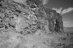 Figure 13.92. Overview of CA-MOD-22. |
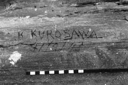 Figure 13.93. World War II-era inscriptions at CA-MOD-22. |
 Figure 13.94. Inscription at CA-MOD-22. |
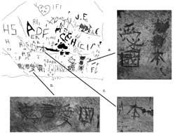 Figure 13.97. Japanese inscriptions on a detach boulder at Petroglyph Point. |
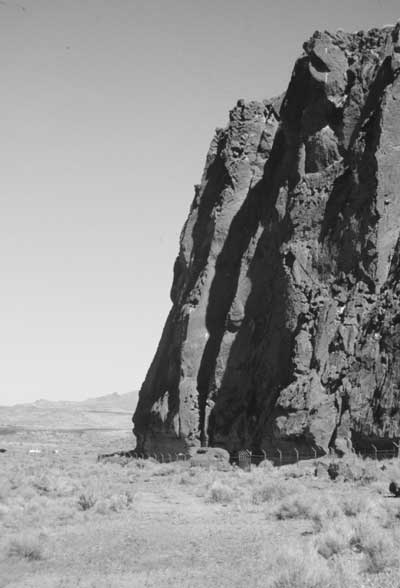 Figure 13.95. Petroglyph Point, Lava Beds National Monument.
| |
Outlying Areas
Other Features
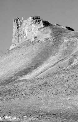 Figure 13.99. Cross on promontory southeast of Newell. |
The relocation center water tanks and most of the wells south of State Highway 139 are still in use. The foundation blocks of the watch tower (CCC fire lookout) on the Peninsula south of Newell are still in place.
Southwest of Newell there is a steel cross on a rock promontory of the Peninsula (Figure 13.99). The original cross of wood was constructed by the evacuees. It deteriorated or was destroyed, and the current cross was placed by the California Japanese Christian Church Federation. A plaque at the base of the cross reads "Tule Lake Christian Ministry Monument — October 2, 1982" and lists the names of the 24 ministers that served the center (Iritani and Iritani 1994).
After Tule Lake was closed the remaining burials at the relocation center cemetery were moved to the Linkville Cemetery in Klamath Falls. There, a small plot contains two grave markers and two other memorials to the Japanese Americans who died at Tule Lake (Figures 13.100-13.104). All are flush to ground. The largest is a brass plaque that is set into a granite slab. It reads: "in memory of deceased internees of tulelake relocation center/flowers faded in the desert wind/(11 names)/dedicated by japanese american citizen league on september 10, 1989." The other memorial is a granite slab that reads: "in memory of deceased/1942-1945/tulelake w.r.a." One of grave markers is a small stone which appears to be a natural boulder on which Japanese and English was inscribed. The English text reads: "dec 6 1942/our baby/j. matsubara." The other grave marker is a shaped concrete piece which contains only Japanese characters translated as "The grave of Kouzo Hamao/Died in June 5th Showa 18(?)/ Sixty-six(?) years old." Both of these grave markers are about 15 inches long. The Matsubara baby is included in the list on the brass plaque, but Kouzo Hamao's name is not.
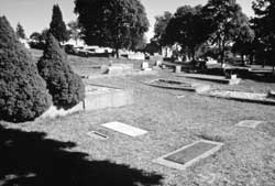 Figure 13.100. Linkville Cemetery, Klamath Falls, Oregon. |
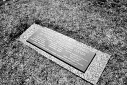 Figure 13.101. Memorial plaque at the Linkville Cemetery. |
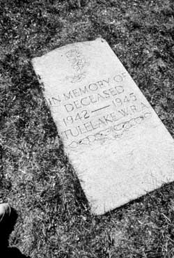 Figure 13.102. Memorial at the Linkville Cemetery. |
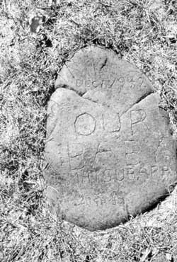 Figure 13.103. Grave marker at the Linkville Cemetery. |
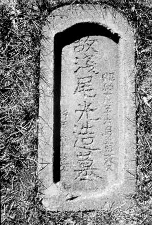 Figure 13.104. Grave marker at the Linkville Cemetery. | |
Interpretation
 Figure 13.107. The Harvey Yoshizuka Sand House at the Caltrans maintenance yard in Newell. |
A large monument of basalt rock and concrete along the north side of State Highway 139 commemorates the relocation center. The monument, dedicated in 1979, incorporates multiple levels of rock walls, a concrete apron, and a state historical marker (Figures 13.105 and 13.106).
In the Caltrans maintenance yard at Newell is the Harvey Yoshizuka Sand House (Figure 13.107). Built in the 1980s, it was named for a young evacuee at the relocation center who is now an engineer working for Caltrans. As an aside, much of the exterior filming of the 1970s television movie "Farewell to Manzanar" was done at Tule Lake.
The Bureau of Reclamation office in Klamath Falls has historical photographs, a large set of blueprints (see Appendices), and other files from the relocation center. They also have a couple of office chairs that were made at the Tule Lake evacuee-operated furniture factory.
There is a small exhibit about the Tule Lake Center at the county fairgrounds museum (Cohen 1994), and Lava Beds National Monument maintains a small collection of ceramics and other artifacts from the relocation center (Figures 13.108 and 13.109). An interesting item in the Lava Beds collection are some metal pieces that would go over the lower end of a roof rafter (the end showing under the eaves) embossed with Japanese characters that translate as "May happiness come here."
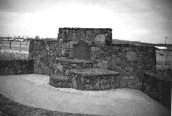 Figure 13.105. Monument along State Highway 139. |
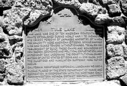 Figure 13.106. Detail of state historic marker. |
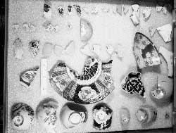 Figure 13.108. Japanese ceramics from the Tule Lake Relocation Center in the Lava Beds National Monument collections. |
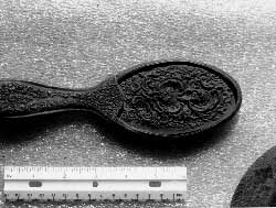 Figure 13.109. Ornate hair brush from the Tule Lake Relocation Center in the Lava Beds National Monument collections. |
| <<< Previous | <<< Contents>>> | Next >>> |
wacc/74/chap13.htm
Last Updated: 20-Feb-2004