|
National Park Service
Confinement and Ethnicity An Overview of World War II Japanese American Relocation Sites |

|
Chapter 16
Assembly Centers
Although Executive Order 9066 authorized the evacuation of all persons of Japanese ancestry from the West Coast, at the time it was signed there was no place for the Japanese Americans to go. When voluntary evacuation proved impractical, the military took over full responsibility for the evacuation: on April 9, 1942, the Wartime Civilian Control Agency (WCCA) was established by the military to coordinate the evacuation to inland relocation centers. However, the relocation centers were far from ready for large influxes of people. For some, there was still contention over the location; for most, their placement in isolated undeveloped areas of the country exacerbated problems of building infrastructure and housing. Since the Japanese Americans who lived in the restricted zone were perceived to be too dangerous to go about their daily business, the military decided it was necessary to find temporary "assembly centers" to house the evacuees until the relocation centers could be completed.
The assembly centers would require open space for housing, the immediate availability of water and power, and a geographic context that would make it easy to confine and separate the evacuees from the general population. In addition, to expedite the evacuation and eventual transfer to the relocation centers, facilities had to be centrally located with access to roads and railroads. Within 28 days, 17 assembly centers were prepared for use. Nine were at fairgrounds, two were at horse racetracks (Santa Anita and Tanforan, California), two were at migrant workers camps (Marysville and Sacramento, California), one was at a livestock exposition hall (Portland, Oregon), one was at a mill site (Pinedale, California), and one was at an abandoned Civilian Conservation Corps camp (Mayer, Arizona). In addition, the "reception centers" under construction near Parker Dam in Arizona (Poston) and in the Owens Valley of eastern California (Manzanar), originally set up to expedite the voluntary evacuation, were also employed as assembly centers. Both would later be designated relocation centers as well.
The assembly centers were surrounded by barbed wire fences. Armed military police, housed in a separate compound, patrolled the perimeter. Existing structures were adapted for use as offices, infirmaries, warehouses, and mess halls. At the racetracks, stables were cleaned out for use as living quarters and at the Portland Assembly Center over 3,800 evacuees were housed under one roof in a livestock pavilion subdivided into apartments. However, housing for the most of the evacuees consisted of hastily constructed "Theater of Operations"-type barracks buildings grouped into blocks with separate communal bathrooms and dining halls.
Most of the barracks were built directly on the ground or supported by wooden foundation blocks; 2- by 4-inch floor joists supported wooden floors. In a few assembly centers, some barracks had concrete or asphalt floors. Walls were made of horizontal boards covered with 30 lb. felt or one-ply roofing paper. Gable roofs (or shed roofs as at the Puyallup Assembly Center) were constructed with 2- by 4-inch rafters sheathed with boards and a single layer of roofing. The barracks buildings were divided into 20 ft by 20 ft rooms with wooden partition walls extending from the floor to the top of the outside wall line, leaving open a space above the interior walls to the roof. Each room had one door and two or more windows (American Red Cross 1942).
Beginning May 26, 1942, some 500 evacuees a day were transferred from the assembly centers to the relocation centers. Slowed by construction delays at the relocation centers and the lack of certain supplies (DeWitt 1943), transfers dragged on over a five-month period and were not completed until October 30, 1942.
Fresno Assembly Center, California
The Fresno Assembly Center was located at the Fresno County Fairgrounds. Occupied from May 6 to October 30, 1942, it was the last assembly center to close. It held a total of 5,344 evacuees (with a maximum of 5,120 at a time) from the central San Joaquin Valley and Amador County. Over 100 barracks served by six sets of communal buildings were located within the infield of the fairgrounds racetrack, and four contiguous blocks with 20 barracks each were located adjacent to the fairgrounds (Figure 16.1).
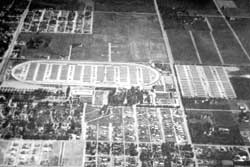 Figure 16.1. Oblique aerial view of the Fresno Assembly Center. (from DeWitt 1943) |
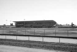 Figure 16.2. Grandstand at the Fresno County Fairgrounds today. |
There are no assembly center remains or any historical marker at the site. Most of the fairgrounds has been changed so extensively from its 1942 appearance that it is difficult to determine whether any fair buildings present during the assembly center use still remain (Figure 16.2).
Marysville Assembly Center, California
The Marysville Assembly Center was located at a migrant workers' camp about 8 miles south of Marysville. It was also known as the Arboga Assembly Center after the nearby small community of the same name. Occupied from May 8 to June 29, the assembly center housed a total of 2,465 evacuees (2,451 maximum at a time) from Placer and Sacramento counties. In July, soldiers occupied the center (Marysville Appeal-Democrat 7/16/1942).
Construction was begun March 27 and the center was considered ready for occupancy by April 16. However, the arrival of the evacuees was delayed: late rains had left pools of water and rough roads necessitating further grading and filling. The assembly center had 160 buildings, including 100 barracks, five dining halls, and two infirmary buildings (Figure 16.3). There were 15 fire hydrants and the military police had their own barracks and headquarters just outside the entrance (Marysville Appeal-Democrat 5/4/1942).
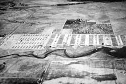 Figure 16.3. Oblique aerial view of the Marysville Assembly Center. (from DeWitt 1943) |
 Figure 16.5. Site of the Marysville Assembly Center today. |
 Figure 16.4. Map of the Marysville Assembly Center today. (click image for larger size (~44K) ) |
Today the assembly center site lies south of Broadway one-quarter mile east of Feather River Boulevard, northwest of the Lake Golf and County Club (Figure 16.4). The area is now privately owned farm fields and residences and there is no historical marker at the site (Figure 16.5). The assembly center site itself lies on two properties, with two separate owners.
Most of the assembly center site is encompassed in the northern parcel along Broadway. On that property there is a single house and associated sheds, none of which appear to be from the World War II era. There is also a silted-over 25- by 30-foot slab of uncertain age and some scattered pipe and concrete in the field area, and exposed pipes and concrete rubble along the bank of Clark Slough on the western edge of the site (Figure 16.6). Frank Makamura of Marysville, who had been interned at the assembly center, indicated that the Japanese American Citizen's League had an interest in placing a plaque on the property but had been unable to get agreement from the owner. The property owner has since passed away, and at the time of this report, the property was for sale.
The 1942 aerial photograph indicates that barracks and other buildings were also located on the second parcel, located to the south. According to that property owner, old water pipes were dug up when he recently built his house (Nathan Mayo, Personal Communication, 1996). Also on the southern property there are small trash scatters likely related to the assembly center. These include a small area adjacent to the slough with about 250 small fragments of white and buff hotel ware ceramics, some of which have the U.S.Q.M.C. base mark indicating army-issue (Figures 16.7 and 16.8). In the dry slough bank just west of the ceramics were noted 30 sanitary seal cans, a rubber boot sole, over 20 amber and clear glass fragments, and a few white glass fragments. Additional trash may be buried and the area may have been the assembly center dump.
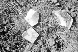 Figure 16.7. Hotel ware ceramics at the site of the Marysville Assembly Center. |
 Figure 16.8. Hotel ware ceramics at the site of the Marysville Assembly Center. |
 Figure 16.6. Concrete rubble at the site of the Marysville Assembly Center. |
Later trash (post-1950) is also present nearby, including over 40 church-key opened steel beverage, sanitary seal, and condensed milk cans, a bed frame, and a clear round whiskey bottle base embossed with a 1951 date code.
The World War II-era deposit is significant in that it is the only known assembly center dump. In fact, it may be the only assembly center dump still extant: the urban setting of most of the assembly centers suggests trash deposits must have been destroyed by later development or the trash may have been originally hauled off to local city dumps. Excavation and analyses may provide interesting comparisons with later relocation center dumps.
Mayer Assembly Center, Arizona
The Mayer Assembly Center, 75 miles northwest of Phoenix, utilized a former Civilian Conservation Corps (CCC) camp identified as Camp F-33-A. With only 245 people, it had the smallest population of any assembly center, and also the shortest occupation, May 7 to June 2. All of the evacuees were from southern Arizona.
 Figure 16.9. Map of the CCC Camp No. F-33-A, Mayer, Arizona, 1939. (Prescott National Forest files) (click image for larger size) |
A July 1941 inventory of the CCC camp lists 26 buildings, including four 50-person barracks, a headquarters, a mess hall, an officers quarters, a recreation hall, two garages, a warehouse, a supply building, a blacksmith shop, a school building, an oil house, a shop, an infirmary, two bath houses, two pit latrines, and a flush toilet (Figures 16.9 and 16.10). Before the CCC camp was built, the land had been previously used for farming.
 Figure 16.10. CCC Camp No. F-33-A, Mayer, Arizona, 1939. (Sharlot Hall Museum Library/Archives, Prescott, Arizona) |
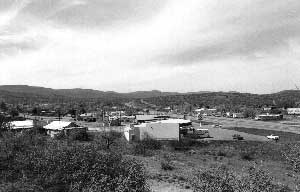 Figure 16.11. Site of the Mayer Assembly Center today. |
All of these buildings were likely still present when the assembly center opened May 7, 1942. A newspaper article reported that the evacuees were "establishing gardening and [a] recreational facility" prior to being transferred to the Poston Relocation Center (Prescott Evening Courier 6/5/42).
Nothing remains of the assembly center today; State Highway 69 from Phoenix to Prescott crosses the site of the assembly center at the current town of Mayer (Figure 16.11). Construction of the highway, along with stores, restaurants, offices, and other businesses, have obliterated all traces of the assembly center. However, local residents confirmed the location of the CCC Camp and that the evacuees did have gardens while they were there.
Merced Assembly Center, California
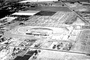 Figure 16.12. Oblique aerial view of the Merced Assembly Center. (from DeWitt 1943) |
The Merced Assembly Center, in the central San Joaquin Valley, was within the town of Merced at the county fairgrounds. Occupied from May 6 to September 15, it housed a total of 4,669 people (with a maximum of 4,508 at one time) from the northern California coast, west Sacramento Valley, and the northern San Joaquin Valley. Historical photographs show about 200 buildings at the assembly center, most located south of the fairgrounds proper (Figure 16.12).
A State of California historical marker is located at the main pedestrian entrance to the fairgrounds (Figure 16.13). Some fair buildings visible on the 1942 aerial photograph may remain, but there have been extensive changes at the site. Behind (south of) the fairgrounds the former barracks area is now a gravel parking lot. Eleven concrete foundations there may be from the assembly center: the slabs are in poor condition, but most measure approximately 20 ft by 100 ft, the standard barracks size (Figures 16.14 and 16.15). Concrete floors for temporary barracks were unusual, if not unique, given the assembly centers' hasty construction. The only relocation center with concrete barracks floors was Granada, where, coincidentally, the internees at Merced were transferred.
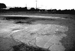 Figure 16.14. Concrete slabs at the Merced County Fairgrounds. |
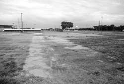 Figure 16.15. Concrete slab at the Merced County Fairgrounds. |
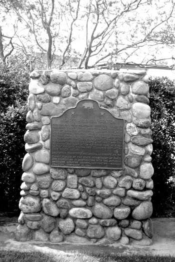 Figure 16.13. Monument at the Merced County Fairgrounds. |
Pinedale Assembly Center, California
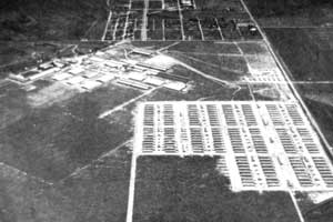 Figure 16.16. Oblique aerial view of the Pinedale Assembly Center. (from DeWitt 1943) |
This assembly center was located 8 miles north of downtown Fresno on vacant land near an existing mill-workers housing area (Figure 16.16). The area is now within the Fresno city limits, north of Herndon Road 1 mile west of Blackstone Avenue.
Occupied from May 7 to July 23, the Pinedale Assembly Center housed a total of 4,823 evacuees, with a maximum of 4,792 at a time. The evacuees were from Sacramento and El Dorado counties, and Oregon and Washington. Ten barracks blocks, each with 26 buildings, were constructed for the evacuees, and a separate block was built for the military police and administration.
The large industrial/warehouse complex visible in the 1942 aerial photograph is still present, which provided confirmation of the assembly center location (Figure 16.17). However, the site of the assembly center is now a subdivision; the architectural style and mature vegetation suggest the housing development dates to the 1950s or 1960s (Figure 16.18). There is no historical marker at the site. Subdivision roads appear to generally follow the assembly center roads.
 Figure 16.17. Warehouses near the site of the Pinedale Assembly Center. |
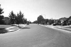 Figure 16.18. Site of the Pinedale Assembly Center. |
Pomona Assembly Center, California
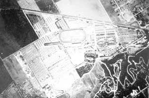 Figure 16.19. 1942 aerial photograph of the Pomona Assembly Center. (from DeWitt 1943) |
The Los Angeles County Fairgrounds (Fairplex) was the site of the Pomona Assembly Center. There is no historical marker at the site. Used from May 7 to August 24, the assembly center held a total of 5,514 persons, with a maximum population of 5,434 at one time.
Evacuees confined at Pomona were from Los Angeles, San Francisco, and Santa Clara counties. Over 300 barracks were constructed at the center, along with eight H-shaped buildings with combined bathroom, shower, and laundry facilities (Figures 16.19 and 16.20). Four baseball fields are visible on the 1942 aerial photograph.
The grandstand and other fair buildings on the 1942 aerial photograph remain (Figure 16.21). The barracks area of the assembly center is now used for the fair midway, other events, and parking. Eight stable buildings are in the same location as on the aerial photograph. Since they are constructed of metal and somewhat modern looking, these may not be the same stables in use at the time of the assembly center. Further, although evacuees were housed in stables at Santa Anita and Tanforan, it is not clear if stables at other assembly centers were used for housing, too. Currently people caring for the horses live in small housing units at the ends of the stables.
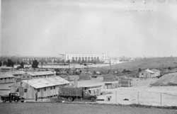 Figure 16.20. Pomona Assembly Center. (National Archives) |
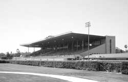 Figure 16.21. Grandstand at the Los Angeles County Fairgrounds (Fairplex) today. |
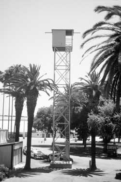 Figure 16.23. Racetrack media tower at the Los Angeles County Fairgrounds (Fairplex). |
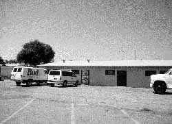 Figure 16.22. Barracks building at the Los Angeles County Fairgrounds (Fairplex). One current building at the fairgrounds looks like those built by the military for the assembly center (Figure 16.22). The 20 foot by 100 foot building was likely moved to its present location from elsewhere within the fairgrounds, since no building is shown in this location on the 1942 aerial photograph. It appears to be only slightly modified. Two towers near the Fairplex racetrack and stables do not appear to be guard towers remaining from the assembly center use. Their great height, small windows, and metal superstructure suggest that if they were they have been greatly modified (Figure 16.23). |
Portland Assembly Center, Oregon
 Figure 16.24. Oblique aerial view of the Portland Assembly Center. (from DeWitt 1943) |
The Portland Assembly Center was centered around the 11-acre Pacific International Livestock Exposition Pavilion. A total of 4,290 people from northeast Oregon and central Washington were interned there between May 2 and September 10, 1942. Over 3,800 evacuees were housed under one roof in the pavilion, which was subdivided into apartments, a kitchen, and dining hall. Outlying buildings included a hospital, a laundry, other support facilities, and the military police compound. The North Portland Harbor, a branch of the Columbia River, is just north of the assembly center (Figure 16.24).
The assembly center site, now the Portland Exposition Center, is in nearly continuous use with trade shows, exhibits, and other events. A memorial plaque in the entrance lobby on the east side of the pavilion describes the role of the center in World War II (Figure 16.25). The front column facade at the original entrance on the north side of the pavilion has been removed. The north entrance is now for emergency use only, since it opens directly onto Marine Drive, a busy multi-lane road (Figures 16.26 and 16.27).
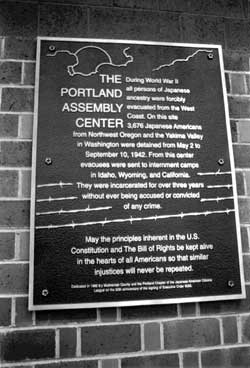 Figure 16.25. Historical marker inside the Portland Exposition Center. |
 Figure 16.26. Portland Assembly Center. (National Archives photograph) |
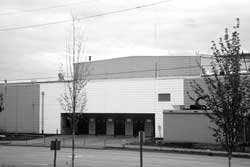 Figure 16.27. Portland Exposition Center today. |
World War II-era photographs of the assembly center dining hall show the current ceiling trusses and columns, which have since been painted black (Figures 16.28 and 16.29). The assembly center buildings surrounding the exposition hall are gone, replaced by asphalt parking lots for exhibitors and the general public. Quonset huts visible in the aerial photograph are gone as well, replaced by more parking lots. Where support buildings once stood, west of Force Avenue, there are now stockyards for farm animal exhibition.
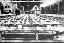 Figure 16.28. Portland Assembly Center. (National Archives photograph) |
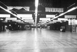 Figure 16.29. Interior of the Portland Exposition Center. |
Puyallup Assembly Center, Washington
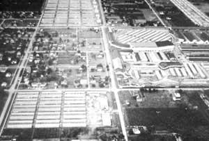 Figure 16.30. Oblique aerial view of the Puyallup Assembly Center. (from DeWitt 1943) |
Used from April 28 to September 12, 1942, the Puyallup Assembly Center was located in a small rural community about 35 miles south of Seattle. Also known as "Camp Harmony," the assembly center was built on the grounds and surrounding acres of the Western Washington State Fairgrounds. In addition to the usual stables, racetrack, and other buildings common at the other assembly centers, there was a rollercoaster (Figure 16.30). The assembly center housed a total of 7,628 Japanese American evacuees from Washington and Alaska, with a maximum of 7,390 at a time.
Construction of the assembly center, which would
effectively double the city's population, was reported as a major event
in the local paper:
"With a suddenness that marks all U.S. military moves these days, construction of housing facilities on a scale large enough to accommodate 8,000 Japanese was begun Saturday morning on the 40 acre parking lot of the Western Washington Fair here, after an order for building the project had been given out by the army officers just a few hours previously. Approximately 1,000 men are now employed on the job, which has been ordered completed within a month. Yesterday afternoon more than 40 of the 15 by 40 foot buildings were nearly completed. According to one source, approximately 165 such structures will be needed to house evacuated Japanese who will be brought here from areas designated by the army." (Puyallup Press, 4/3/42).
Another contemporary observer was not impressed with the quality of construction or design:
"At the Puyallup fairgrounds ... all was a madhouse of swarming carpenters. Boxlike buildings were being thrown together on a large field that was formerly the parking lot. First the grass was scraped off the surface of the field with steam shovels. Then 2 by 4s were laid on the ground and planks nailed onto them. Then walls with one tiny window every twenty feet in the rear wall, no windows on the side, and a small door (no window in it) at the front. Over all a tarpaper roof. There will be approximately 40 rows of these rabbit hutches. Four hutches to a row, six rooms to a hutch. Each room is about 20 feet square and separated from the next room by a partition that runs up part way to the roof. Each room is to house a Japanese family. If there is an average of 5 persons to a family, our arithmetic says 4800 people will be living in these boxes this summer." (Conard 1942).
Barracks filled all available space at the fairgrounds, including beneath the grandstand, within the circle of the racetrack, and in parking lots that extended into adjacent neighborhoods. The assembly center was divided into four distinct and separate areas designated Districts A-D. Movement between the districts, which were divided by fences, was restricted. District A was the first to open and housed about 2,000 people, District B housed 1,200, District C housed 800, and District D, which included the racetrack, administration, and bachelor's barracks, housed 3,000.
 Figure 16.31. Sculpture at the Puyallup Fairgrounds. |
 Figure 16.32. Commemorative plaque at the Puyallup Fairgrounds. |
The assembly center site, still used as a fairgrounds, is in continual use for exhibits, trade shows, and concerts, as well as the annual Puyallup Fair. The fairground administration building is in the same location as in the 1940s, but is apparently recent as the current building is much larger and taller. Sculpture and two plaques in a courtyard outside the fair administration building honor the evacuees (Figures 16.31 and 16.32). The plaques, on a short concrete pedestal, indicate the monument was dedicated by the governor and lists contributors. The sculpture, by George Tsutakawa, is a steel cylinder about 10-foot high which depicts several human figures. Within the fairgrounds the barracks and horse racetrack are gone. The grandstand burned in the 1970s, and was replaced by the present concrete and steel grandstand. The infield now has a covered stage for shows and concerts (Figures 16.33 and 16.34).
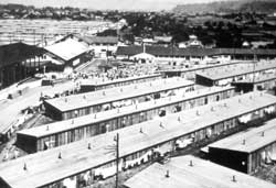 Figure 16.33. View from the grandstand of barracks at the Puyallup Assembly Center. (National Archives photograph) |
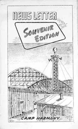 Figure 16.35. Cover of the Souvenier Edition of the Camp Harmony Newsletter. (University of Washington, Special Collections) |
 Figure 16.34. View from the grandstand at the Puyallup Fairground today. |
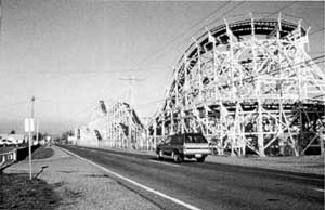 Figure 16.36. Wooden frame roller coaster at the Puyallup Fairground today. |
Other former barracks areas outside the fairgrounds, now parking lots, show no evidence of their former use. The southern end of the original site, where the assembly center hospital was located, is now completely obliterated by State Highway 512. The grading to accommodate this freeway-sized multi-lane road changed the topography completely. The wooden frame roller coaster, along the western boundary of the fairgrounds next to 5th Street, is still in use (Figures 16.35 and 16.36).
Sacramento Assembly Center, California
Constructed at a migrant workers camp 15 miles northeast of downtown Sacramento, this assembly center was also known as Walerga. It was occupied for 52 days, from May 6 to June 26, and held a total of 4,770 persons, with at maximum at one time of 4,739. Evacuees were from Sacramento and San Joaquin counties. Aerial photographs indicate there were 11 blocks with over 225 buildings (Figures 16.37 and 16.38); one block was likely devoted to the military police and administration.
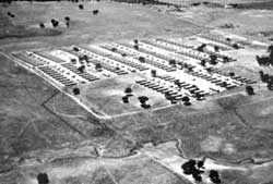 Figure 16.37. Oblique aerial view of the Sacramento Assembly Center. (from DeWitt 1943) |
 Figure 16.38. Sacramento Assembly Center. (National Archives photograph) |
The assembly center area is now bisected by Interstate 80 and covered by recent housing subdivisions in what is now the "Foothill Farms- North Highlands" area of Sacramento. There is a historical marker, a ramada, and a small grove of cherry trees at a small neighborhood park and playground (Walerga Park) at the northwest corner of Palm Avenue and College Oak Drive, within what once was the assembly center (Figure 16.39). The monument incorporates a small concrete slab that may be a remnant assembly center foundation (Figure 16.40).
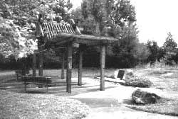 Figure 16.39. Ramada and historical marker at Walerga Park. |
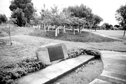 Figure 16.40. Historical marker and grove of cherry trees at Walerga Park. |
Salinas Assembly Center, California
Occupied from April 27 to July 4, the Salinas Assembly Center was built at a fairgrounds at the north end of the town of Salinas. It housed a total of 3,608 evacuees from the Monterey Bay area. The maximum population at one time was 3,594. Over 165 buildings are depicted in the aerial photograph, which shows barracks to the north and east of the fairgrounds proper, six buildings within the racetrack infield, and perimeter guard towers (Figures 16.41 and 16.42).
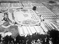 Figure 16.41. Oblique aerial view of the Salinas Assembly Center. (from DeWitt 1943) |
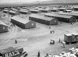 Figure 16.42. Salinas Assembly Center. (Clem Albers photograph, Bancroft Library, University of California, Berkeley) |
The fairgrounds now encompasses the California Rodeo Grounds, a small neighborhood park (Sherwood Park), and the Salinas Community Center. The grandstand and auxiliary buildings present in the 1942 aerial photograph remain, but the main area of assembly center barracks is now a golf course. In the rear courtyard of the Salinas Community Center there is a State of California historical marker commemorating the assembly center and a small fenced Japanese garden (Figures 16.43 and 16.44). Another historical marker indicates that the assembly center was later used to train a Filipino army unit during World War II. The courtyard is perhaps most known for its cowboy hat sculpture "Hat in Three Stages of Landing" (Figure 16.45).
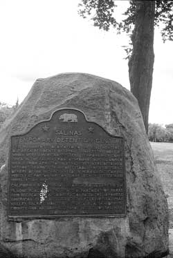 Figure 16.43. Historical marker at the site of the Salinas Assembly Center. |
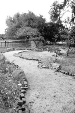 Figure 16.44. Japanese garden in the courtyard of the Salinas Community Center. |
 Figure 16.45. Two of the "Three Hats" in the courtyard of the Salinas Community Center. |
Santa Anita Assembly Center, California
Located at the world-famous Santa Anita Racetrack (Figures 16.46 and 16.47), the Santa Anita Assembly Center was the longest occupied assembly center, used for 215 days, from March 27 to October 27. It was also the largest assembly center, housing a total of 19,348 persons from Los Angeles, San Diego, and Santa Clara counties, with a maximum at one time of 18,719. Those interned lived in hastily constructed barracks and in existing stables, with 8,500 in converted horse stalls (Figures 16.48 and 16.49).
 Figure 16.46. Santa Anita Assembly Center. (National Archives photograph) |
 Figure 16.47. Construction underway at the Santa Anita Assembly Center. (National Archives photograph) |
The assembly center was divided into seven districts: District 1 had 21 stable buildings converted into barracks, District 2 had 20 stable building, District 3 had 19 stable buildings, District 4 had four stable buildings and 113 freshly-built military barracks, District 5 had 161 barracks, District 6 had 160 barracks, and District 7 had 155 barracks (Lehman 1970). Bachelors were housed in the grandstand building. There were six recreation buildings, six showers, six mess halls (referred to by color; Blue, Red, Green, White, Orange, Yellow), a hospital, and a laundry (Figure 16.50; Santa Anita Pacemaker various issues 1942). There was a large warehouse and an automobile storage yard in the racetrack infield and the grandstand seating area was used for a camouflage net factory which employed the Japanese Americans.
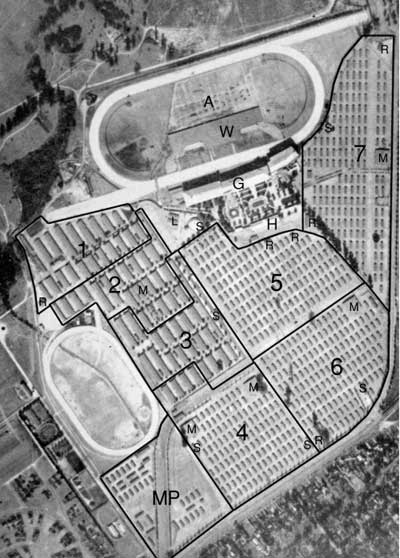 Figure 16.50. 1942 aerial photograph of the Santa Anita Assembly Center; A - automobile storage, G - grandstand (housing), H - hospital, L - laundry, M - mess hall, MP - military police and administration area, R - recreation building, S - showers, W - warehouse, 1-6 - barracks districts. (adapted from DeWitt 1943) |
There is no historical marker at the site. The areas where the assembly center barracks had been (Districts 4-7) are now paved parking lots, and the District 3 and 4 stables and the military police compound are now a large shopping mall (Santa Anita Fashion Park). However, the massive grandstand and other racetrack buildings present in the 1940s remain (Figures 16.51 and 16.52), as do the horse stalls of Districts 1 and 2. The stables, of wood, are the same as in aerial and historical photographs (Figures 16.53 and 16.54). Security personnel at the stables mentioned that Japanese Americans occasionally return to see their former homes. There are presently as many people (stable workers and their families) as horses living in the stall area.
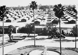 Figure 16.48. Newly-constructed barracks at the Santa Anita Assembly Center. (National Archives photograph) |
 Figure 16.49. Converting horse stalls into housing at the Santa Anita Assembly Center. (National Archives photograph) |
 Figure 16.51. Santa Anita Assembly Center. (National Archives photograph) |
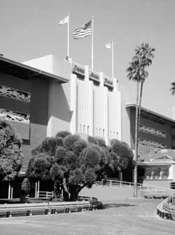 Figure 16.52. Grandstand building at the Santa Anita Racetrack today. |
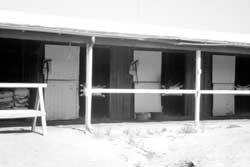 Figure 16.53. Stables at the Santa Anita Racetrack today. |
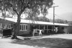 Figure 16.54. Stable residence at the Santa Anita Racetrack today. |
Stockton Assembly Center, California
The Stockton Assembly Center was at the San Joaquin County Fairgrounds. Occupied for 161 days from May 10 to October 17, it held a total of 4,390 evacuees from San Joaquin County, with a maximum population at one time of 4,271. In the racetrack infield there were 125 barracks and another 40 barracks were on the east side of the fairgrounds (Figures 16.55 and 16.56).
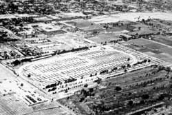 Figure 16.55. Oblique aerial view of the Stockton Assembly Center. (from DeWitt 1943) |
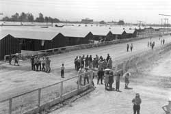 Figure 16.56. Stockton Assembly Center. (National Archives photograph) |
No assembly center or fairground buildings visible in the 1942 aerial photograph remain, but many of the residences and businesses in the vicinity are still present. There is a State of California historical marker at the main pedestrian entrance of the fairgrounds (Figure 16.57).
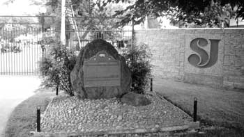 Figure 16.57. Historical marker at the entrance to the San Joaquin County Fairgrounds in Stockton. |
Tanforan Assembly Center, California
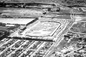 Figure 16.58. Oblique aerial view of the Tanforan Assembly Center. (from DeWitt 1943) |
The Tanforan Assembly Center was located at the Tanforan Racetrack in San Bruno, 12 miles south of San Francisco. Occupied from April 28 to October 13, the assembly center held 8,033 evacuees (with a maximum of 7,816 at a time) from the San Francisco Bay area. The assembly center had about 130 barracks, half within the racetrack infield. In addition, stables were used to house evacuees, as at Santa Anita (Figures 16.58-16.60).
The racetrack, opened in 1899, burned down in 1964 and the area is now a shopping mall (Tanforan Mall). At the southwest entrance of the mall there is a large statue of a racehorse and jockey and a group of historical markers (Figure 16.61). One marker has a brief description of the racetrack and assembly center (Figure 16.62). Other markers commemorate the first airplane flight from a ship, the racehorse Seabiscuit, and an early developer.
 Figure 16.59. Converted horse stalls and barracks at the Tanforan Assembly Center. (National Archives photograph) |
 Figure 16.60. Guard tower at the Tanforan Assembly Center. (National Archives photograph) |
 Figure 16.61. Tanforan Mall. |
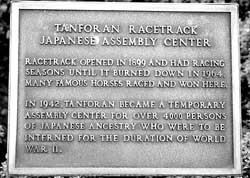 Figure 16.62. Historical marker at the Tanforan Mall. |
Tulare Assembly Center, California
The Tulare Assembly Center was located in the southern San Joaquin Valley in the town of Tulare at the county fairgrounds. Occupied from April 20 to September 4, it housed 5,061 evacuees (with a maximum at one time of 4,978) from Los Angeles and Sacramento counties and the southern California coast. There were about 100 barracks within the fairgrounds proper and another 55 barracks to the south of the fairgrounds adjacent to the county hospital (Figure 16.63). There were eight mess halls and eight sets of communal buildings for bathrooms, showers, and laundries. Administration offices were in the grandstand and surrounding buildings, the assembly center hospital was northwest of the grandstand, and the military police compound was in the northern portion of the fairgrounds.
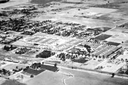 Figure 16.63. Oblique aerial view of the Tulare Assembly Center. (from DeWitt 1943) |
 Figure 16.64. Grandstand at the Tulare Fairgrounds today. |
The grandstand and several buildings in the northeastern corner of the fairgrounds visible in the 1942 aerial photograph are still present (Figure 16.64). The buildings, larger than the barracks, were probably part of the fairgrounds originally. However, a 1942 map (Figure 16.65) confirms they were incorporated into the assembly center. No buildings or features constructed specifically for the assembly center are present, and there is no historical marker at the site.
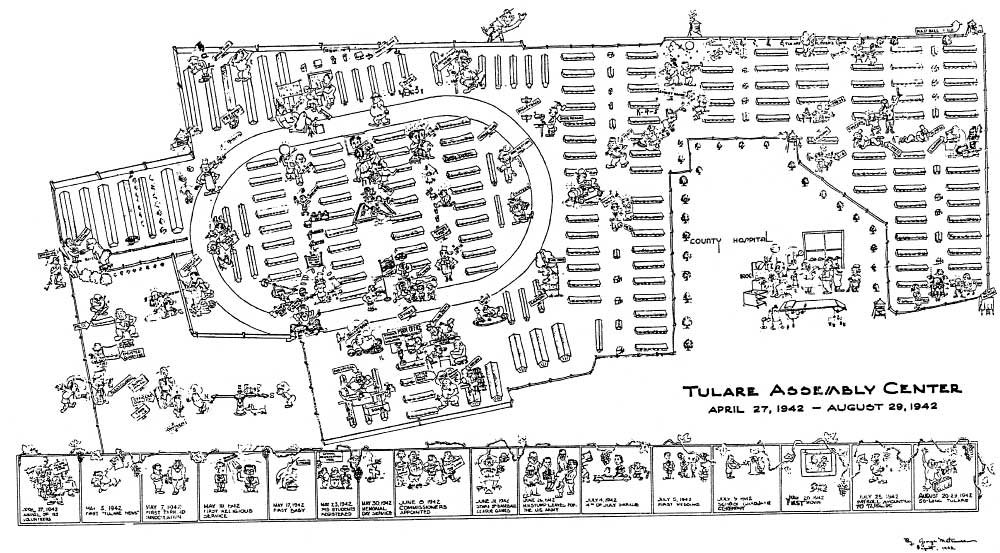 Figure 16.65. Map of the Tulare Assembly Center. (Matsumare 1942) (click image for larger size (~135K) ) |
Turlock Assembly Center, California
The Turlock Assembly Center was at the Stanislaus County Fairgrounds in the town of Turlock. Occupied from April 30 to August 12, it held a total of 3,699 evacuees from the Sacramento River delta and Los Angeles areas. The maximum population at one time was 3,662. After September 14, 1942, the assembly center was used as a U.S. Army Rehabilitation Center where army prisoners received special training and discipline prior to being restored to military duty.
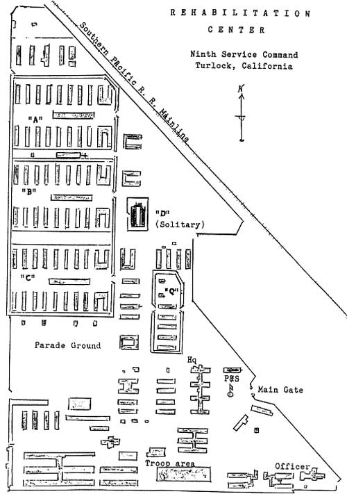 Figure 16.66. Map of the U.S. Army Turlock Rehabilitation Center. (from Santos n.n.) (click image for larger size) |
 Figure 16.67. Oblique aerial view of the Turlock Assembly Center. (from DeWitt 1943) |
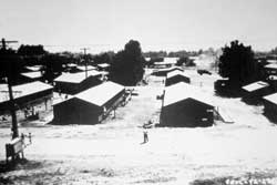 Figure 16.68. Turlock Assembly Center. (National Archives photograph) |
A study of the rehabilitation center lists 150 barracks, 31 latrines, 18 bathhouses, a canteen, an administration building, three hospital buildings, a grandstand, single-pole guard towers, several open sheds, other structures, and a 40-acre victory garden (Figure 16.66; Santos n.d.). The 1942 aerial photograph suggests most of these facilities were also present for the assembly center (Figure 16.67 and 16.68). Oddly enough, the maximum number of army prisoners held at the facility was 1,500. More than twice as many Japanese Americans were confined in the same area, a testament to the crowded and inadequate conditions of the assembly centers.
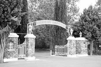 Figure 16.69. Entrance to the Stanislaus County Fairgrounds in Turlock. |
The fair buildings visible in the 1942 aerial photograph remain, but there is no evidence of any assembly center structures, and no historical marker at the site (Figure 16.69). There are a few possible remodeled barracks to the south of the fairgrounds in an adjoining housing development.

|

|
| <<< Previous | <<< Contents>>> | Next >>> |
wacc/74/chap16.htm
Last Updated: 20-Feb-2004