|
MESA VERDE
The Archeological Survey of Wetherill Mesa Mesa Verde National Park—Colorado |

|
A PROLOGUE TO THE PROJECT
DOUGLAS OSBORNE
the broad plan of approach
The report of the archeological survey of Wetherill Mesa by the National Park Service marks the beginning of a series of publications which should formulate reasoned hypotheses, phrase numerous searching questions, and supply some reasonable answers concerning the prehistory of Mesa Verde National Park. The appearance of this report offers me an opportunity to describe the organization and aims of the project. Following this description, I have given a short discussion of the geological and physiographic background of the region, which will serve also for our succeeding publications.
Arthur H. Rohn, Jr., is preparing a monograph on Chapin Mesa, not as part of the Wetherill Mesa Project. The publication of this work will make available two comprehensive surveys within a relatively small area. This done, and the archeological and related studies which are the Wetherill Mesa Archeological Project completed, plus other survey and salvage excavations attendant on the planned expansion of the park, will, when accomplished, altogether make Mesa Verde National Park one of the most intensively studied archeological zones in the world.
The mesa merits such intensive examination, and even more, the entire Four Corners area. It is the Anasazi heartland. The Mesa Verde itself is but a small and perhaps atypical part of the region that supported the bearers of the Mesa Verde cultural style. Furthermore, the single largest excavation program of the past, that of J. Walter Fewkes, of the Smithsonian Institution, which still forms the physical basis for much of the park's interpretive program, has never been adequately reported. The regions around the Mesa Verde, particularly to the west, have not been surveyed. There are notable exceptions in terms of intensive effort but these are lost in vast areas which support a more than liberal sprinkling of Mesa Verde type sites. Literally hundreds of these have been lost during the last two decades because of agricultural expansion. No large problem of northern Anasazi archeology can be settled until Montezuma County is better known. This project, however, is not geared for that task.
The need for a full-scale and intensive research program at Mesa Verde has long been recognized, both as a desirable increase in knowledge and as a practical matter. As the park has become more and more popular, increasing thousands of visitors have come to see its great outdoor museum. As early as the 1930's, perhaps before that, park personnel were talking of expanded offerings or more efficient use of them. The project is, from the point of view of Mesa Verde National Park, part of a larger master plan which will result in a major rearrangement of the park's facilities and in an entirely new plan for accommodating visitors.
Serious consideration of additions or major changes in the park began in the late 1940's or early 1950's. By the late 1950's, during the incumbency of Superintendent Oscar Carlson, the desirability of a major archeological project which would achieve both park expansion and scientific information was accepted locally. By 1957 and 1958 planning was proceeding in earnest, and Carroll Burroughs, then park archeologist, was carrying most of the load for formulating financial estimates, staffing requirements, and organization of general facilities for a large project. By the winter of 1957-58 plans were on the drawing boards; in the spring of 1958 I was asked to supervise the project.
There appears to have been no question that Wetherill Mesa should be selected for the site of the park's new archeological expansion. This small area contained several ruins already famous; one of them, Long House, is the second largest cliff dwelling within the park. Wetherill Mesa was accessible by a rather rough road, constructed originally because of a disastrous fire on and around the northern section of the mesa in 1934.
The first regular staff member to arrive was Alden C. Hayes, who began work as archeologist in August 1958. I arrived early in September, and George S. Cattanach, archeologist, came in late September. Hayes' task was to be the survey, Cattanach's the excavation of Long House. All three of us managed to get into the field for short periods in autumn, when Cattanach did some preliminary clearing and examining of the Long House ruins and Hayes surveyed in the northern part of Wetherill Mesa.
The winter of 1958-59 was spent in organizing and shaping the project. We worked in the small auditorium in the museum building at park headquarters, and an old Civilian Conservation Corps building was given to us as a warehouse. Fortunately the first autumn and spring were remarkably open, and we were able to plan the camp and the excavation program on the ground. The Federal money authorized for the project that year, the fiscal year ending June 30, 1959, was approximately $60,000, of which about a third was set aside for salaries. Circumspection in the purchasing of supplies and materials was in order; the camp had to he built and field and laboratory items acquired. Government surplus property, fortunately rich and varied at that time, provided a large amount of equipment at substantial saving. Gretchen G. Hayes, Richard P. Wheeler, and Arthur H. Rohn, Jr., were recruited in 1959 as secretary, museum curator (or laboratory chief), and archeologist, respectively. Rohn spent his first field season at Long House assisting Cattanach, who at that time was responsible for building the camp as well as excavating the large site.
One of the important tasks in 1959 concerned the project's office and laboratory. The building, prefabricated steel on a concrete slab, 120 feet long by 50 feet wide, was begun in the spring and occupied early in September. In addition to Wheeler as the laboratory chief, the laboratory was staffed with five museum aids, none of whom had experience in anthropological work but all learned rapidly. In a remarkable lack of turnover, four—Ruth E. Chappell, Jean Lee, Sue Waite, and Gisele L. Eberling—have, to this date, been long-term employees, all recruited locally. Lucy P. Wheeler was engaged as a secretary in November of 1961.
Fieldwork started early in the spring of 1959 with two major objectives: the excavation of Long House, and the establishment of the camp and its facilities. Work went on concurrently in the two, and the camp, above and slightly west of Long House, was well established by autumn. A frame and sheet iron laboratory-office was built, 17 tent frames of 4 different sizes were constructed, and a water tank was purchased and set up. The roads in the camp area and cleaning up of the camp were also completed. An engine room and tool shed were built early in the summer; two 15kw diesel-powered generators were installed and the camp was wired.
During this summer Cattanach was in overall charge of the fieldwork and camp building. Rohn assisted in the excavation of Long House, and James A. Lancaster was transferred from the park's maintenance staff to take charge of the stabilization program. Hayes and his survey crew were busy on the talus slopes and cliffs of the mesa.
The winter of 1959-60 began the laboratory work in earnest. The cataloging system in use by the Museums Branch of the National Park Service, for which we were, ultimately, doing the cataloging of the Wetherill Mesa material, was adjusted to a suitable method for application in a research laboratory. The spring of 1960 saw the laboratory staff caught up with the previous year's fieldwork and ready to embark on current material.
During this year the field staff was reorganized to put Hayes, who now had the survey work moving well, in charge of the field operation. Lancaster, made available to the project throughout the entire field season, took over direction of the excavations. Cattanach was able to put in full time at Long House; Rohn was assigned to the new excavation of Mug House. J. Anthony Pomeroy served as seasonal archeologist during the summer, taking series of pollen samples and partially excavating Sites 1205 (a small rock shelter) and 1539 (a terrace and check-dam site).
Frank H. H. Roberts, Jr., Smithsonian Institution; Emil W. Haury, University of Arizona; J. O. Brew, Harvard University; and Robert H. Lister, University of Colorado, had been requested by the Director of the National Park Service to advise him on the conduct and progress of the project. This group held its first meeting at Mesa Verde in May 1960, and has since given valuable assistance and advice on our field and laboratory work. One of the major changes which this advisory group suggested in its first meeting was that a mess be installed in the camp. This suggestion had been discussed and discarded for the first year but the second year's National Park Service appropriation for this project gave us the financial potentiality to set up a kitchen and messhall, and staff it adequately. The mess was open for operation in mid-July 1960, and has since furnished our crews with excellent provender. During fiscal year 1960 the project had an authorization of nearly $81,000 of Federal funds, of which slightly over $52,000 went to salaries and wages.
The archeological survey was completed early in the autumn of 1960; the survey crew had recorded 800 sites and tested several small ones and other isolated manifestations.
The following spring of 1961 Hayes completed excavation of Site 1205 and started work on Site 1452, a mesa-top Pueblo II—Pueblo III ruin. It was named Badger House because of the large numbers of badger holes in the trash dump. Badger House was scheduled for completion during the 1963 season.
Our laboratory staff was augmented in January 1961 by Carolyn M. Osborne, who serves as textile analyst, cataloger and professional assistant. Fred E. Mang, Jr., came in November of the same year as project photographer.
All major excavation and stabilization at Long House and at Mug House were complete at the end of the 1961 season. Robert F. Nichols assisted Cattanach at the former site during the 1961 season. Nichols rejoined the project as archeologist in May 1962. Jervis D. Swannack, Jr., also joined the staff in the same capacity and at the same time.
An interpretive survey was made of the Wetherill Mesa in the summer of 1961 by Jack R. Rudy, assistant park archeologist, Mesa Verde National Park. Rudy examined the areas which appeared to offer the best interpretive possibilities, as recommended by Hayes on the basis of the archeological survey, and submitted alternative suggestions for the interpretive loop. Sites have been chosen which will follow one another along the road and will lead the visitor on a logical trip from the earlier into the later archeological manifestations. Obviously the research value of the individual sites was also considered in setting up the plan for the mesa-top excavations.
Plans for the summer of 1962 included a continuation of the Badger House excavation and the excavation of Basketmaker III pithouses, Site 1644, by Hayes, excavation and stabilization of Step House by Nichols, and excavation of two mesa-top sites, 1595 (Pueblo II—III) and 1645 (Pueblo II) by Swannack. These sites, after excavation and stabilization is complete, will be "moth-balled" to await the time when interpretive needs of the park will call them into use. Major responsibility for planning and controlling excavations and the stabilization of all ruins will rest on the shoulders of Lancaster, as did the work in Long House and Mug House. The summer of 1963 should see the end of all fieldwork on Wetherill Mesa. A single Pueblo I site (1676) will be excavated then. Mopping-up operations and preventive stabilization will complete our work on the mesa. The project will continue laboratory and desk activities until early in 1965.
The National Geographic Society was informed of the development of the Wetherill Mesa Archeological Project by Conrad L. Wirth, Director of the National Park Service, who is also a member of the board of trustees of the National Geographic Society. Early in September 1958 Melville Bell Grosvenor and other officials of the Society came to Wetherill Mesa to examine its possibilities for an extended research effort. Shortly thereafter the National Geographic Society made a grant of $50,000 to the National Park Service to undertake research activities connected with the project that could not be supported by Federal funds (these are specifically for excavation, stabilization, laboratory work, and writing of the archeological reports). There are numerous problems of prehistoric life which every archeologist hopes for an opportunity to explore. The plans of attack on these research problems were worked out and found acceptable to the Society, which made three additional research grants of $50,000 each in 1960, 1961, and 1962.
PUBLICATIONS
The publication program contemplated by the project is a large one. We plan monographic treatment of the survey and of each site excavated, followed by specialized studies of certain aspects of the archeological recovery. These reports will he published in essentially the same manner and format as is this one.
Each of the special aspects of ancillary research supported by the National Geographic Society program—about 32 in all—will either contribute to the site monographs or be published independently. The soil, ecological, and dendrochronological-climatic studies will obviously all require separate treatment; the dendrochronology itself and others will appear with the site reports.
Summary reports covering both aspects of the project's program, together with a concluding study, will close the series. This first report in the Wetherill Mesa series was edited by Margaret A. L. Harrison, of Santa Fe, N. Mex. George A. King, of Denver, Colo., has prepared the maps and charts for the present text.
FUNDING
The project is envisioned as expending some $795,000, by the National Park Service, of Federal money. This figure is supplemented by $250,000 from the National Geographic Society. Fiscal data and the breakdowns which will indicate the uses to which these funds were put will be available to interested investigators at the end of the project. Such a record may be of value to others planning similar programs of coordinated research.
DISCUSSION
I cannot see any useful purpose in discussing the administrative problems involved in starting and maintaining the National Geographic Society program. As in any program, these will vary with the origin of funds, the administrative base, and the problems encountered. A short statement on the history of each aspect of our research will appear in a foreword or introduction to the resulting publications.
On the other hand, the problems attendant on the development of such a research design are worthy of mention and exposition. A catholicity of research tastes must be both consulted and controlled. Too wide or inclusive an approach to programing should be rejected. The amputation of an effort once started, such as the Tanoan oral-tradition study, can be painful. Ordinarily a program is designed and only then the funds are sought, thus bringing a detailed background knowledge to bear on the design. Here, funds were available before the program was considered in any detail. This caused some strain in the planning and some false or incomplete starts. Although research organization difficulties were ironed out readily enough, the problems caused have echoed in the yearly budgets. Thanks to the understanding shown by higher echelons of the National Park Service and by the National Geographic Society Research Committee, budgetary changes have been allowed.
The environmental measurements-dendrochronology-climate aspect of the program is an excellent case in point. The stations first became part of the program because we needed answers to questions concerning local weather variation and because a modern study of ecology must have these data. Their possibilities for correlation of climate with a detailed study of present-day tree growth via the dendrographs and the potentialities of these data for a more detailed interpretation of the past followed soon after.
There can be no doubt that the problems of a program such as ours will have a bearing on the development and handling of future interdisciplinary endeavors, large and small. The project has by no means covered every possibility that exists for bringing the content and methods of other fields to bear on archeology. But it has enlisted the aid of a respectable share of the most obvious ones, and some that are not immediately obvious. Interdisciplinary attacks on a group of discrete problems, as a valued method, have been strongly in the air for some time; and anthropology generally and archeology specifically have not been wholly backward in seeking outside participation. The National Geographic Society-supported program is not the first nor will it be the last of such activities. This increases rather than lessens its responsibilities to the scientific community.
Richard B. Woodbury of the University of Arizona was asked to offer a critique and commentary at the end of the Wetherill Mesa Project's Symposium held at the American Association for the Advancement of Science meetings at Denver in December 1961. I can do no better than to quote, with his permission, his thoughtful remarks on the subject:
But is would be unrealistic to overlook the potential problems that the very scope of the project raises, problems in the relating of each separate research program to the others and in their successful combination when the field work is completed and results are published. It seems to me that we have here a testing ground for the whole future of relationships between archeology and other scientific studies, a relationship that promises much more than has thus far been actually achieved. Three quite crucial questions will ultimately be answerable, on the basis of the work at Wetherill Mesa; and the answers will influence the organization and direction of future archeological research.
The first question is whether archeology can really ask sufficiently significant questions of other disciplines. Will the questions, by and large, be important enough to justify the time, expense, and diversion of attention by specialists in all the diverse fields that are being called on? If the questions are trivial or of too limited a nature, even though meaningful in a technical sense, they will have been unnecessary or even wasteful of scientific resources. Archeologists are thus challenged to frame each inquiry with great care, and in terms of the greatest possible promise for results of major value.
The second question is whether the specialists and the fields they represent can answer the significant questions asked. Doubtless at least a few questions will be unanswerable and a few will get equivocal answers. But most of them must be capable of answers that truly advance archeological understanding and insight, or the joint efforts of archeology and other studies will be unrewarding.
The third question is whether the archeological work can provide data of real value to the cooperating specialists, for work in their own fields. It would be tragic if collaboration of the kind established by the Wetherill Mesa Project could produce only a one-way advantage, archeology receiving help and giving nothing in return. For this pattern of joint endeavor to be followed in the future, benefits must flow in both directions, and the nonarcheological disciplines be advanced approximately as much as they contribute to the advance of archeology.
I can add here only two more points that are, to me, part of the responsibility that the project bears. They are of a slightly different order than those mentioned by Woodbury but they must, I feel, be kept in the foreground during the modeling stage of any project. First, there is the responsibility for diffusing the knowledge and viewpoints we have gained. Presumably specialists will have sufficient access to results and method through the specialized monographs. Whether we like it or not, the ivory tower is vanishing; and the general public must have access to the same results, obviously in a broadened and generalized interpretation. In our case, the National Park Service's interpretive program and the National Geographic Society will handle certain aspects of this interpretation, each in its own way. I believe this project should more than repay the public for the money we have spent, and should insure its interest in spending more for other similar projects. The present-day development of "Big Science" and the potentialities inherent in rapid popularization indicate the nature of our responsibilities along these lines.
The second point is this: a large project can experiment with new techniques and methods whereas a smaller endeavor must ordinarily hew more closely to tried and true lines. I believe that it is a responsibility of any scientific activity to probe and experiment, and that this is especially true of larger and adequately financed ones. True, it is a ticklish business, and temptation to ramify is strong. When properly controlled and reported, ancillary investigations can contribute markedly to scholarly advance, through actual increase of knowledge or improvement of method, or through elimination of unprofitable approaches. Time will tell whether or not the choices made here were the right ones.
|
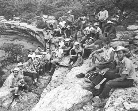
| Field crew—1959, on ledge above Long House. |
| <<< Previous | <<< Contents>>> | Next >>> |
archeology/7a/prologue.htm
Last Updated: 16-Jan-2007