|
MESA VERDE
The Archeological Survey of Wetherill Mesa Mesa Verde National Park—Colorado |

|
THE ARCHEOLOGICAL SURVEY OF WETHERILL MESA (continued)
miscellaneous observations
Many random bits of data and items of material culture were collected during the course of the survey that were not of a sufficient volume to warrant a separate discussion but should be recorded here.
CEREMONIAL SITES
Isolated ceremonial sites were mentioned in the discussion of the Mesa Verde Phase. Fourteen were found consisting of one or more kivas, a tower, or a kiva-tower association, but these were without attached living quarters.
Seven of these fourteen can be associated with nearby sites. The probable association of Sites 1207 and 1209 has been mentioned above (p. 101). Site 1167 is a kiva in a cave immediately below the cliff edge in the head of Long Canyon and probably served one or both of the unit pueblos (Sites 1168 and 1176) on the mesa above it. Site 1201, three kivas in a cave south of Long House, and the single kiva in Site 1295 may have been used by occupants of Long House. The lone kivas in small caves, Site 1317, 300 feet southeast of Kodak House, and Site 1387, about 500 feet south of Double House, were possibly associated with those two cliff dwellings. Site 1364, consisting of three kivas and a tower at the base of a butte at the end of the long ridge between Bobcat and Long Canyons, was probably the ceremonial complex for Site 1368 on top of the butte.
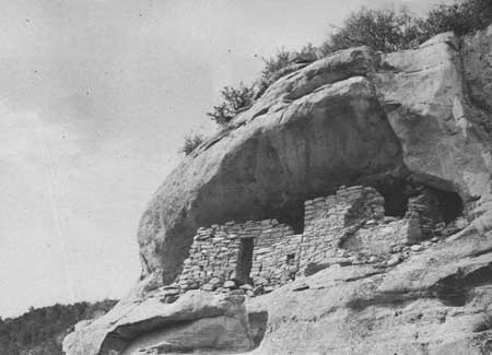
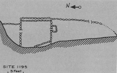
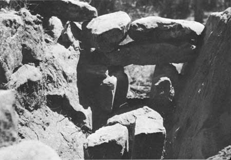
Several sites with a solely religious function were so far removed from habitations that associations cannot be suggested. The kiva and square tower, Site 1253 in Rock Canyon, have been discussed. Also falling into this category are isolated kivas, Site 1135 in the bottom of Rock Canyon and Site 1814 on the ridge east of Bobcat Canyon. A cave in Long Canyon, Site 1195, contains an unusual structure illustrated in figures 95 and 96. Here a rectangular room, 9 by 10 feet, was built from cave floor to roof. A door or window measuring 10 by 20 inches placed 3 feet above the floor leads into a small room which fills the remaining cave area to the north of the large rectangular room. In the south wall of the latter, at floor level, is an opening barred with sticks set in the masonry. On the outside of the wall the opening is enclosed in a masonry wall, 1 foot high and open at the top. This seems to have served as a ventilator. Low, narrow masonry benches were built along the east and west walls. A niche, 6 by 6 inches, is incorporated in the east bench and a larger one, 12 by 15 inches, is located in the south wall, 2 feet off the floor between the west bench and the ventilator. At some later date the east wall was refaced on the outside with classic masonry and the remaining area of the cave to the south of the kiva, which is what it seems to be, was walled in, making a single room 21 feet long. This last wall was pierced by two doors, the northernmost was partly filled still later to reduce it to the size of a small window. The remaining door, the largest noted on the survey, was 5.5 feet high.
|
| Figure 95—Site 1195 in Long Canyon. Room at right is square kiva. Note unusually high doorway at left. |
|
| Figure 96—Sketch map of Site 1195. |
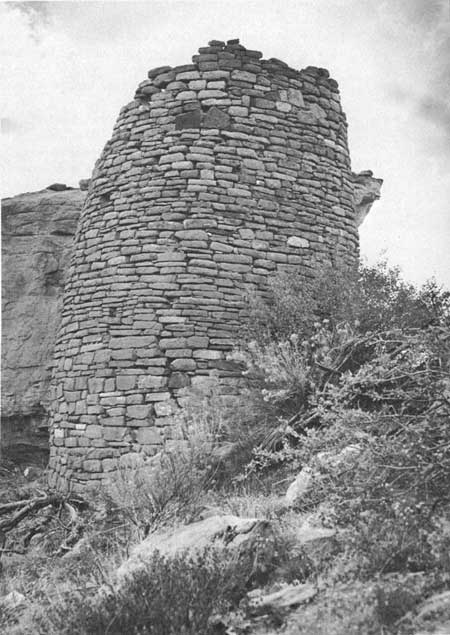
Site 1275, on the narrow ridge east of Rock Springs Canyon, is a circular tower 20 feet in diameter built of pecked rock. The maximum wall height at present is 4 feet; from the amount of rubble at its base one would guess that it was never over 6 or 7 feet high. There is no other structure in the vicinity. Site 1601, a small circular structure on the point to the north of the Long House rincon, may be the remains of a Pueblo II tower. The site was excavated by the survey crew to reveal a hard-packed adobe floor 5.5 feet in diameter. The masonry wall, for a third of the circumference, is based on upright slabs of chipped-edge rock. Present wall height averages 1 foot. There is not enough fallen rock on the mound to raise the height more than another 2 or 3 feet. Either the structure was low or was robbed of stone by later builders. One more site classed by the survey as a possible tower may have had another use. Site 1782, on the ridge east of Bobcat Canyon, is built against a low sandstone outcrop. It is 9 feet in diameter, circular, and built of coursed masonry, too weathered to reveal the technique used in shaping the stone. The wall still stands to the height of 2 feet, and it is doubtful if it was ever more than 4. Slabs of sandstone 2 to 3 feet broad lying in the center may have been a roof covering at one time supported by timbers.
|
| Tower at Site 1138. |
SHRINES
Just as artifacts of unknown use are often called "ceremonial objects," so is there a tendency to ascribe an esoteric function to architectural forms that do not fit an understood pattern. The sites that I have called shrines are of two types: the first, a monument of carefully stacked stones, and the second a more complex walled-in area.
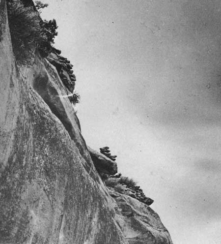
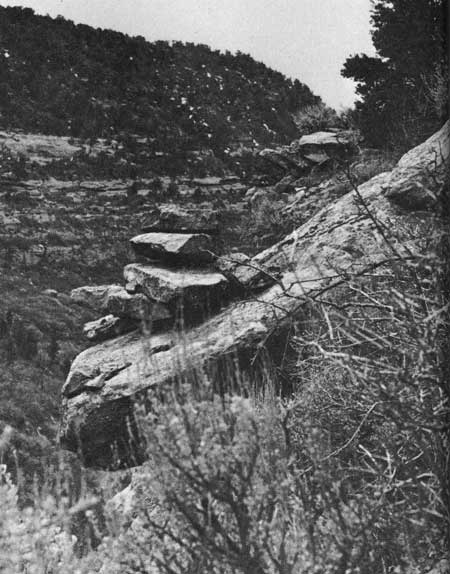
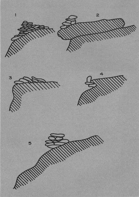
In the first category, Site 1213 is a series of five monuments on the extreme outer edge of the cliff facing Long Canyon above the caves containing Sites 1199 and 1217 (figs. 97, 98). From north to south the first four monuments average 28 feet apart, but only 15 feet separate the fourth and fifth. As can be seen in figure 99, considerable care was taken in laying up the stone to hold the monuments to precarious perches. A similar pile of stones was built on the rounded cliff edge immediately above the three-room cliff dwelling, Site 1236, on the east side of Wildhorse Mesa.
|
| Figure 97—Stone monuments on cliff edge. Site 1213. |
|
| Figure 98—Two of five monuments on cliff edge. Site 1213. |
|
| Figure 99—Sketch of stone monuments, numbered from north to south. Site 1213. |
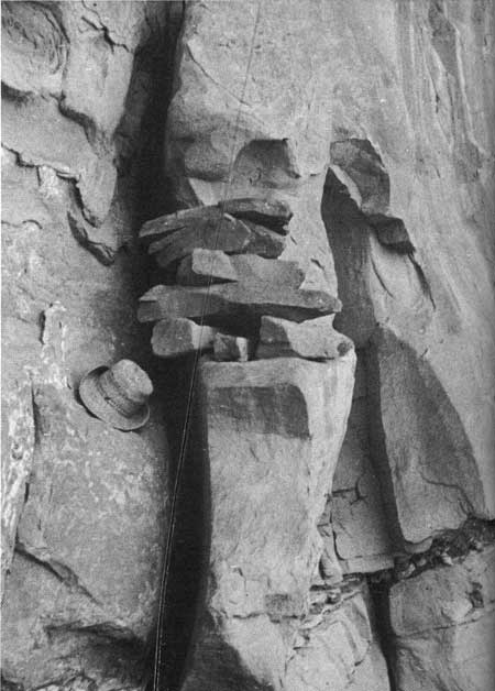
Site 1422 is a monument, seven courses high, on a small projecting ledge 5 feet above the base of a sheer cliff in Long Canyon near the south end of the mesa (fig. 100). Dorsey (1902, p1. CIV) illustrates a monument similar to those described above at Mishongnovi, one that was at that time used as a shrine in connection with the Snake Dance ceremonies.
|
| Figure 100—Rock monument on cliff ledge in Long Canyon, isolated from any habitation. Site 1422. |
The second type of shrine is represented on Wetherill by only two sites, which are so classified by default. Neither seems to fit any more mundane purpose. Site 1146 is at the tip of the long ridge between Long Canyon and its West Fork, built on a low ledge which breaks off sharply into Long Canyon. Two double walls of scabbled masonry, 12 to 15 feet long, parallel each other about 3 feet apart. The walls are joined at one end by a low terrace wall which curves below them on the steeper slope. Site 1214 is in a similar situation on more level ground on the point of the short ridge between the eastern and middle tributaries to the head of Long Canyon; it looks down on a bench to the southeast that was thickly populated during the McElmo Phase. Here two low double walls form an ell with legs 5 to 7 feet long. The open angle is partially enclosed by a low curving simple wall, one stone wide. None of the walls in either of the sites appears to have enough stone to raise them over 2 or 3 feet.
Historic shrines at Mishongnovi (Dorsey, 1902), Oraibi (Voth, 1901), and Zuni (Stevenson, 1904) assume several shapes but the most common is a three-sided masonry structure 3 to 4 feet high and about as wide, covered with slabs. It is possible that Sites 1146 and 1214 were similar and served the same purpose.
Two other sites which may have had some ceremonial or religious significance have to stand in classes by themselves. Site 1545, on top of a narrow ridge west of the draw which goes into Rock Canyon over Jug House, is a walled enclosure 15 feet square. Masonry of large stones now stands 2 feet high with enough rubble present to indicate that it was originally of normal room height. There are no signs of cross walls, and the span from wall to wall is greater than that of an average room; it would be difficult to roof without additional support. A depression in the center indicates a floor level lower than the surrounding ground surface.
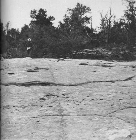
The bottom of the watercourse draining into the rincon north of Long House is, for a considerable distance, a broad expanse of exposed bedrock. At a point about 400 feet above the pouroff is Site 1588. Here a channel has been pecked into the rock for a distance of 100 feet down the middle of the wash. At its upper end it starts just below a 2-foot ledge in the bedrock, travels down the middle of the arroyo bed rather than following the lowest levels of the stream channel, and in the last 30 feet descends a steeper grade to end in a narrow basin (fig. 101). The groove averages about 2 inches wide and 1 inch deep. It could have served no purpose in collecting water.
|
| Figure 101—Long groove pecked into bedrock of water course. Site 1588. |
FIREBOXES
Thirteen slab-lined fireboxes or firepits were surveyed; all but three were isolated from any habitation and could hardly have been used for ordinary cooking. Those that were surveyed as part of a house site were also somewhat removed from the house itself. Site 1110 is a McElmo Phase pueblo on the mesa. A slab firebox 2 feet long is 100 feet to the south below the toe of the trash mound. A similar slab box is built against a large boulder, which forms its fourth side, on the talus near the south end of the mesa. It sits only 20 feet from a one-room house, Site 1528. A D-shaped slab-lined pit 7 feet across is situated 15 feet north of a one-room Ackmen Phase house at Site 1459. All others surveyed were located at considerable distances from any house.
Nine of the 13 were rectangular, ranging from 12 to 30 inches wide and from 24 to 40 inches long and averaging 22 by 31 inches. The remaining four had curving or partly curving outlines with two circular, one D-shaped, and one elliptical. These averaged 7 feet long. The consistently smaller size of the rectangular fireboxes suggest a possibly different function of the two shapes. Excavation of five of the boxes, however, showed more similarity than difference.
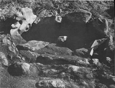
Site 1231, northeast of Rock Springs, is in the bottom of a shallow draw with a gentle slope, 42 feet below a check dam (Site 1116). It is built of nine vertical slabs, and is almost square with an inside measurement of 31 by 33 inches. This was the first of the type found on the survey, and because of its position in the bottom of an intermittent stream channel and proximity to an agricultural terrace, it was thought to be a shrine—and, of course, I do not know that it was not. Because of it, the crew referred to the canyon which evolves from this draw as Shrine Canyon. The box was originally included under the number of the series of terraces, but a return trip was made 6 months later to excavate it, and at that time it was assigned a site number of its own.
A floor of flat pieces of burned sandstone was found 12 to 16 inches below the top of the upright slabs (fig. 102). Beneath the floor was a shallow layer of 1 to 2 inches of charcoal which lay on a subfloor of flagstones set into subsoil.
|
| Figure 102—Slab-lined firebox, showing upper layer of flat burned stones in the bottom. Site 1231. |
Site 1800 was a partially destroyed or eroded firepit on the east edge of the ridge east of Bobcat Canyon and was several hundred feet from the nearest ruin. Only one corner and two sides remained of the slab box which had original dimensions of 15 inches wide and over 25 inches long. It was cleaned out to reveal three flat slabs of burned rock lying on subsoil in a thin stratum of charcoal.
On the Long Canyon edge of the mesa almost due east of Rock Springs is Site 1459, a D-shaped enclosure, 7 feet in length, outlined with slabs on edge. The slabs are heavily oxidized by fire. A trowel exposed quantities of broken burnt rock and charcoal at a depth of 8 inches below the top of the upright slabs. There seemed to have been more fire than could be accounted for by a burning house, and more charcoal than one would expect from anything but a jacal wall. The latter should also have produced burnt adobe, which was not found. No rubble of rock indicated the presence of a masonry structure above the slabs. The small Ackmen Phase house 15 feet to the southeast may or may not have had a temporal association, but it was included under the same site number.
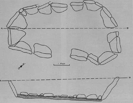
Site 1695 is a circular firepit located on the tip of the point west of the Kodak House rincon. Four burned slabs arranged in a semicircle are all that show from the surface. If the arc were continued, the area enclosed would be 10 to 12 feet across. Pitting with a trowel uncovered flat, burned slabs 6 inches below the surface. Under the slabs was a layer of fine charcoal 3 inches deep. On the point west of Long House rincon, at the edge of the project's camp, were two upright slabs thought to indicate another of the small rectangular fireboxes. A pit there was completely excavated to reveal a somewhat elliptical "tub" 6.5 feet long by 3 feet wide (fig. 103). The slabs outlining the structure were not perpendicular but sloped outward at an angle of about 30°, thus the dimensions of the bottom of the pit were less than on the surface. A foot below the surface was a "floor" of rough, unshaped rocks showing no evidence of fire. They lay on 1 to 3 inches of charcoal on fire-hardened adobe floor. Some of the larger pieces of charcoal were identified as juniper.
|
| Figure 103—Firebox. Upper figure, a ground plan of box lined with upright slabs; lower figure, a cross section showing layer of charcoal on floor and paving of burned, rough rock. Site 1871. |
The 13 sites share enough features to suggest a common function. All are lined with upright slabs; none show any evidence of a superstructure. All were shallow pits averaging 8.3 inches from the top of slab to the stones in the bottom, with a range of 6 to 15 inches. All but two, Sites 1118 and 1528, both unexcavated, show signs of fire. All but the three mentioned earlier are far removed from a house site, and the temporal association of those three with the houses near them is not known. All five that were excavated or tested have charcoal on the floor and all have stone either in or just above the charcoal. In none of the pits was there any cultural material which would be helpful in dating. The slabs of the box at Site 1528 had chipped edges, which suggest the Mancos Phase or later.
The size of the structures, both lateral and in depth, eliminates the possibility that they were houses. A few are large enough for sweat houses but the evidence of fire inside and the lack of a pile of burned rocks outside obviate that likelihood. The relative isolation does not suggest an ordinary cooking fire for the preparation of meals, but the possibility of field cooking remains. Cushing (1920, p. 204) has described the baking of corn in the husk in deep bottlenecked ovens dug at the fields near Zuni, and identical ovens have been found in archeological sites (Morris, 1939, p. 111; Kidder, 1958, p. 92). Though different in character than the bell-shaped underground pit, the Wetherill Mesa fireboxes could have served as bake ovens. If fires were built in the pits and after burning down were covered with stones, corn in the husk laid on the stones and covered with stalks and earth should be well cooked in 8 to 12 hours. After the overburden and the corn were removed, only the rocks and charcoal would remain. But our pits are far too small to handle more than a few ears, and most of the sites are farther from the best corn land than they are from habitations.
Cushing (1920, p. 257) also describes small ovens built of sandstone slabs which were used at Zuni for baking unleavened cornmeal cakes by placing alternate layers of cake and hot sandstone slab in the preheated oven. These appear to be similar to the small vented, subterranean ovens used in the Hopi towns for baking mush (Mindeleff, 1891, p. 163). The small Zuni and Hopi ovens are located immediately outside their houses and require the use of ground meal. There would seem to be little purpose in leaving home to do the baking.
The fact that charcoal rather than ash is found in these pits indicates that the fires in them were smothered while still burning. The flat stones on top of the charcoal probably caused or helped to cause the smothering of the fires.
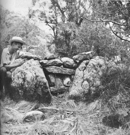
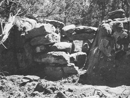
One more site remains to be discussed in connection with the fireboxes. Because of some differences in construction it was separated from the 13, but perhaps it should fall into the same category. On a level bench midway on the talus slope in Long Canyon, and 50 feet north of a 10-room Mancos Phase pueblo, Site 1426; was a crack in a large boulder walled in at each end. The structure was assigned site number 1427. The rock, colluvial detritus from the cliff above, had maximum measurements of 4 feet in height and 13 feet in length. It had split vertically, forming a V-shaped crack 10 feet long, 2 to 4 feet deep, and averaging 2 feet wide at the top (fig. 104). Each end was walled in with large, scabbled rock—the north end completely and the south end leaving an aperture 0.6 to 0.9 foot. The chamber thus formed, with an inside length of 7 feet, was covered with large slabs of rock (fig. 105).
|
| Figure 104—Vault made by walling in ends of crack in colluvial boulder. Site 1427. |
|
| Figure 105—Site 1427 after excavation. Walls at each end are visible. |
The site was excavated in September 1959. The rock on the interior was fire-reddened, and 0.4 foot of fine charcoal covered the floor. A few small fragments of unbroken charcoal appeared to be of sagebrush. On the floor, protruding above the charcoal and just inside the aperture in the southern wall, were three more or less cube-shaped rocks 0.7 foot high (fig. 106). The structure may have been a corncrib which suffered an accidental fire or may have been used as an oven with the opening in the south wall serving as a vent.
|
| Figure 106—Interior view of vault and three stones on floor, after removal of charcoal. Site 1427. |
STEPS
A common architectural manifestation on Mesa Verde, where much of the travel was across sloping rock, is a series of steps. No such series were accorded survey numbers or described separately, but were usually recorded when they occurred in or near habitation sites. Many occurrences were noted at sections of cliff far from a cliff dwelling but were not recorded. Though no systematic collection of data was made, it should be noted here that they exist.
Steps on Wetherill can be classified as of three types. By far the most common is the shallow, cup-shaped "toe- and handhold" pecked into the rock. These are found from few to dozens at or near almost every cliff dwelling. Notable examples negotiate the cliff at each side of the small rincon at Double House.
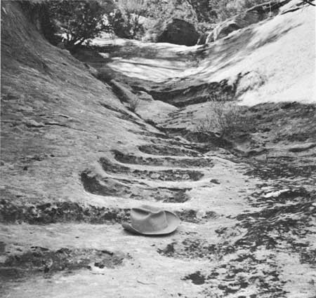
More elaborate and less numerous is the type shown in figure 107. The series of 10 steps illustrated, part of a flight of 50 in the bottom of the steep gulch below Jug House, made easier passage to the spring on the talus below. Broad, level treads and vertical risers have been laboriously cut into the living rock with a pecking stone. Other examples of the type are found in a series of 11 steps cut into the cliff face immediately under the cave at Site 1187. The lower end of this stairway ends in midair and was probably reached by a 10- to 20-foot ladder from a foot of the rock. Several well-made steps are found at the top of the cliff at the head of a chimney leading down to the talus north of Ruin 16.
|
| Figure 107—Steps carved in bedrock in wash below Jug House. |
The third type of stairs is made by setting broad slabs of stone into the earth. The long flight which gave its name to Step House is the only good example of this on Wetherill Mesa, although there is a suggestion of such construction at two or three other sites. Their eroded condition made exact designations uncertain.
PICTOGRAPHS
Pictographs were recorded at 27 sites. Only one, Site 1341, was of pictographs alone; the others were found at or near a cliff dwelling. The majority were placed on a smooth section of cliff face or on a collapsed piece of it, a few were on cave ceilings, and still fewer on masonry walls. As the sandstone is easily scored with a sharp chert fragment, most of the pictographs were scratched or engraved into the rock, but many were pecked—with loss of line control. Figures were also painted on stone or plaster; probably more of this was done than the evidence now indicates. In several locations flecks of red, white, or yellow paint were found on cliff walls, remains of a larger figure now eroded away. A pictograph in charcoal was found at only one site.
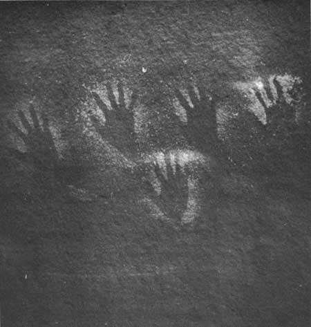
The symbol, or picture, appearing most frequently, both in individual occurrence and in the number of sites where it is found, is the imprint or outline of a human hand. Most of these were made by placing the hand in a slurry of wet plaster and slapping it on the smooth rock. At Site 1364 the shapes of three hands are pecked into the rock; at Sites 1341 and 1882 hands are outlined in negative design, possibly by a mouthful of thin adobe soup (fig. 108). Stevenson (1904) reports many negative handprints at a Zuni shrine 6 or 7 miles south of the pueblo.
|
| Figure 108—Handprints in negative design on cliff face at Site 1341, south of Kodak House in Rock Canyon. |
The next most common element is a bird track. People from Acoma, Santa Ana, and Zia pueblos who observed identical designs on pottery in the project laboratory referred to them as turkey tracks.
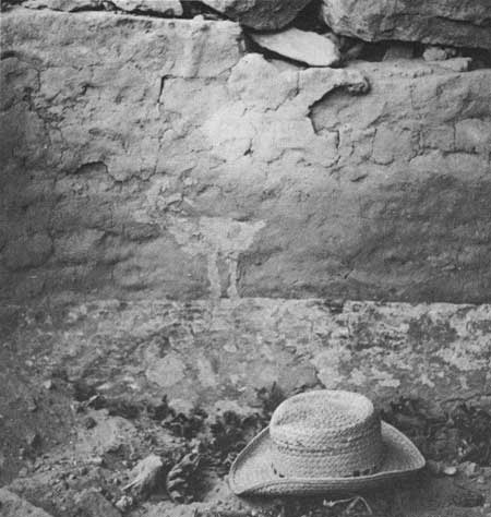
Next in numbers but found at only three sites are animal figures. Several horned quadrupeds, probably bighorn, appear on the cliff below Ruin 12 cave, and a sheep is painted in white over red plaster on a kiva pilaster at Double House (fig. 109). A series of doglike animals were placed on the rocks at Site 1882, a cliff dwelling on Wildhorse Mesa.
|
| Figure 109—Mountain sheep in white on red background painted on plaster. Kiva pilasters in Double House. |
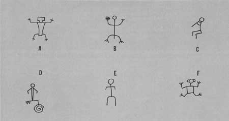
Anthropomorphic figures were fewer in numbers than those of animals but were found at six sites. Figure 110 shows typical examples.
|
| Figure 110—Anthropomorphic pictographs. A, from Site 1320; B, C, from Site 1890 on Wildhorse Mesa; D, from Site 1527; E, from Site 1450; F, from Site 1370. |
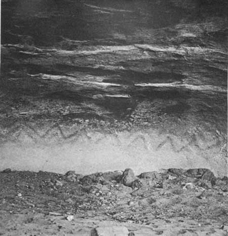
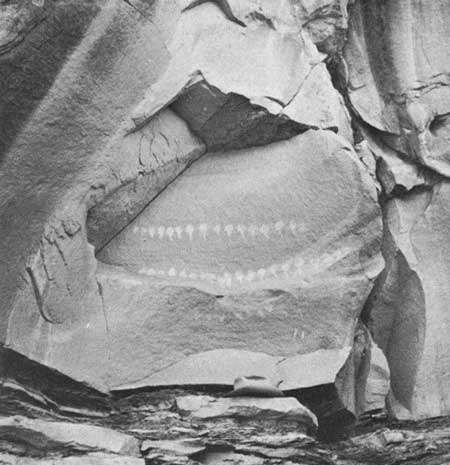
Observed at five sites were nested or concentric circles or rectangles, and at four sites a tight spiral. A zigzag snake or lightning design was also found at five sites; that at Site 1227 (fig. 111) was painted in red at the back of the cave. At Site 1341 was a series of 30 or more "tadpoles" in mud on the smooth cliff face (fig. 112). Perhaps the two taus, with the same outline as the T shaped doorway, which appear on a fallen rock at Site 1421, should be placed in the same category. The tau was found by the Coltons near Willow Spring in the Hopi country. According to their informant, it symbolized a cloud, the mark of the Cloud clan, which also used a tadpole or rainbow as a clan symbol (Colton, 1931).
|
| Figure 111—Zigzag pattern painted on rear wall of cave. |
|
| Figure 112—"Tadpoles" in mud on cliff face. Site 134. Site 1227, north of Mug House. |
Recent petroglyphs include the names or initials of 28 individuals and two cattle brands (the Wetherills' Open A Diamond is one). The historical value of some of these inscriptions was mentioned in the chapter on the history of the archeology on Wetherill Mesa. The majority of names have been identified as those of explorers of 50 years ago and more.
RECENT SITES
Six aboriginal sites of the recent period were recorded. All can be attributed to Navajos. Site 1234 near the bottom of Rock Canyon west of Rock Springs is an unfinished five-sided log hogan. Only the first course of what was apparently to be a typical cribbed structure was laid. Twenty-five poles cut and stacked nearby were never put in place.
Site 1803, in the drainage of Bobcat Canyon above the pouroff, is a brush-covered, five-sided lean-to, made by running poles between supporting trees. A firepit was placed in the approximate center.
Site 1581 is a brush-covered hogan built on a forked stick framework, and was occupied by Navajo workmen employed by Nusbaum during his excavations in Step House cave.
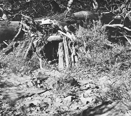
The remaining three sites, 1467, 1476, 1479, are the remains of small sweat lodges; all built with the door to the east and fronted by piles of burned sandstone (fig. 113).
|
| Figure 113—Recent Navajo sweat lodge built against a fallen tree near Rock Springs. Site 1476. |
All these recent sites probably date within the past 70 years, and were likely built either by Navajo workmen employed at the park or as sheepherders for the Utes.
| <<< Previous | <<< Contents>>> | Next >>> |
archeology/7a/survey7.htm
Last Updated: 16-Jan-2007