|
MESA VERDE
The Archeological Survey of Wetherill Mesa Mesa Verde National Park—Colorado |

|
THE ARCHEOLOGICAL SURVEY OF WETHERILL MESA (continued)
phase development
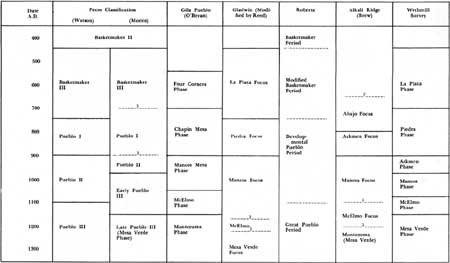
While collecting data from sites, I made at the same time an attempt to relate pottery types with architectural forms and to form tentative categories. Some. labels were needed, when still in the field, in order to separate groupings of related data. I was not yet familiar enough with the material to make the fine distinctions required by the phase system proposed by Gila Pueblo and Deric O'Bryan, yet I hoped for greater definition than that afforded by Roberts' rather general classification (1935). The Pecos classification, familiar to all of us, in spite of its limitations, provided a series of pigeonholes that could be modified or abandoned with the least amount of confusion after all the material had been studied.
The Pecos classification, or a modification of it, is useful for field sorting, but for accurate description of cultural growth it has several drawbacks. The system was conceived at a time when stratigraphic excavation in the Southwest was just beginning, and some of the period descriptions were based on speculation which was not supported by later excavation. Like Morris (1939, p. 34), I learned that early concepts of Pueblo II tried to cover too much ground in accounting for all developments from pithouse to complex pueblo and included much of Pueblo III by classifying Prudden-type unit pueblos as typical Pueblo II. In recent years the Pecos classification has often been so tied to a rigid chronology that its value in ordering cultural stages has been largely lost. Within the Anasazi Province some people were living in subterranean pithouses while others were building great pueblos.

|
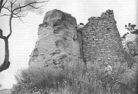
| Site 1454 in Horse Canyon. |
As used here, the Pecos classification refers to general periods applicable to the Anasazi culture area. The stages of development in the specific Mesa Verde subarea will be defined as phases applicable only to this area.
The first attempt to establish a system of phases descriptive of the Mesa Verde Branch and to correlate that system with the Pecos classification was made by Harold Gladwin (1934, p. 28), who proposed a La Plata Phase for Basketmaker III and Pueblo I, a Mancos Mesa Phase equivalent to Pueblo II, and McElmo and Montezuma Phases for early and late Pueblo III. As a result of Gila Pueblo's excavation on Chapin Mesa in 1948-49, O'Bryan (1950, p. 103) was able to separate Basketmaker III, which he named the Four Corners Phase, from Pueblo I, his Chapin Mesa Phase. In working up his material from Mancos Canyon, Reed (1958, p. 160) found Gladwin's original phase system usable by retaining the La Plata Phase of Gladwin to represent Basketmaker III and by giving the name Piedra Phase to the Pueblo I period in the Mesa Verde area.
Excluding agricultural terraces and historic sites from consideration, I felt reasonably sure in fitting 70 percent of the remaining sites into the phase system. Some of these designations are admittedly forced and are indicated with a question mark in table 10 at the back. With such a large body of material a few bad guesses will probably be absorbed in the averages.
Table 6 shows a correlation of the systems describing the succession of cultural periods as used by O'Bryan and Reed, the adaptations of the Pecos classification to Mesa Verde by Watson (1950) and by Morris, with Roberts' general classification for the Anasazi and Brew's phases for Alkali Ridge, and the modifications of the Gladwin-Reed system suggested by the survey material. The dates in the stub of table 6 are approximate.
TABLE 6.—Correlation of various period and
phase systems devised for the Mesa Verde area
(click
to see an enlargement in a new window)
It was one of the hopes of the survey that we could push back in time the record of occupation of the Mesa Verde. Evidences of sedentary pottery-making farmers are plentiful. The environment of the mesa would seem to be as suitable for their precursors as that of Butler Wash, 65 miles west, or of Durango, 40 miles to the east, where preceramic Basketmakers have been found. In this hope we were disappointed, and the suggestions of earlier occupation can be disposed of in short order.
That ancient hunters knew the area is suggested by the find of a projectile point of the Milnesand type. The point, of gray quartzite, measures 52.5 by 21 by 7 mm., weighs 9.5 gm., and is lanceolate with slightly convex base. It is horizontally flaked and has ground sides (fig. 121, third from the right, top row). Unfortunately the point was found on the surface of the arroyo bed in the bottom of Rock Canyon with 5 square miles of drainage area above it.
A suggestion of a Basketmaker II occupation is found in Site 1205, a small cave at the northern end of the mesa near the head of the West Fork of Long Canyon. Here a test trench into trash and alluvium in front of the cave revealed that the bottom 4 feet of the refuse contained charcoal and chert rejects but no pottery. This deep layer was topped by several strata bearing Piedra through Mesa Verde Phase material. No structure relating to the preceramic trash was found. Further testing is planned for the site.
LA PLATA PHASE
Surface evidence of Basketmaker III sites is slight or nonexistent. Although the material is known and common on Mesa Verde, discovery of sites has usually been through prospecting with probe and shovel or through accidental discovery, the result of pipeline or other construction, or by finding a pithouse underlying other structures during the excavation of later sites. On the theory that surface remains are more likely those of a later period, the survey recorded only nine La Plata Phase sites on Wetherill Mesa—two were caves excavated by Nusbaum, three more were caves tested by the survey crew. The frequency with which they have been found on Chapin Mesa implies a similar occurrence on Wetherill. Unquestionably excavation or testing in many of the sites reported as Pueblo I, Piedra Phase, will reveal La Plata Phase structures.
The trait list for the phase includes domestication of turkeys, cultivation of corn and beans, troughed metates, basally notched projectile points, undeformed skulls, and pottery of Chapin Gray and La Plata Black-on-white. Dwellings were shallow pithouses, circular to roughly rectangular, with four roof-support posts, a bench support for sloping wall poles, a firepit often intersected by a low partition wall, and a ventilator that is sometimes narrow but more often a widened antechamber. Houses are oriented with ventilator-entrance to the south or southeast and may be backed by small storage huts on the surface of the ground. The majority of known sites have been on the top of the mesa, but two on Wetherill, Step House and Site 1291 (Nusbaum's excavations), are in caves. Two small caves, Sites 1165 and 1493, showing no traces of occupation except smoke deposit on the ceiling, were tested by trenching. The trenches did not intersect any structural remains but under considerable fill uncovered charcoal, burnt adobe, and Chapin Gray sherds, evidence of use during the La Plata or possibly the Piedra Phase. Probably other cave sites exist under houses of later phases.
Estimated dates run from A.D. 450-550 for the beginning to A.D. 700-750 for the end of the phase. Actual tree-ring dates from La Plata Phase sites on Chapin Mesa run from A.D. 574 to 700.
Excavated examples of representative sites are First and Second Pithouses (Lancaster and Watson, 1954), Pithouses B and C (Lancaster and Watson, 1942), Pit house 1 (Smiley, 1949), Site 145 (O'Bryan, 1950), and Site 1060 (Hayes and Lancaster, 1962), all on Chapin Mesa, and Site 2 in the Ackmen-Lowry area (Martin, 1939). Site 1285 in Step House Cave on Wetherill Mesa should be included, but a report has not yet been published (Nusbaum, n.d.).
The few sites on Whetherill Mesa which could be as signed to the La Plata Phase with some confidence are map 5): 1165, 1285, 1291, 1491?, 1493?, 1506, 1542, 1544,1705.
PIEDRA PHASE
The Piedra Phase marks the transition from year-round residence in semisubterranean pithouses to life in substantial houses above ground. The villages representative of this period are crescentic rows of contiguous rooms of jacal and adobe, often slab based, from one to three rows deep. They are fronted by one or several deep pithouses, sometimes circular and more often rectangular, with rounded corners and narrow ventilator shafts. Both the pithouses and some of those on the surface show signs of having been lived in whereas some of the surface structures seem to have been purely for storage. It has been suggested that the combination of houses may have been for seasonal use, the pits serving as winter shelter, the people moving into the surface rooms in the summer and using the pits for family prayer meetings. The term "proto-kiva" as used by Morris is apt.
The pottery of the preceding phase continued to be used, La Plata Black-on-white giving way sometime during the period to Piedra Black-on-white, though for a time the types were contemporary. Chapin Gray remained the principal utility pottery but banded-neck vessels were introduced. Abajo Red-on-orange occurs in small percentages. The troughed metate and basally notched arrowpoint were still used. The practice of lambdoidal skull deformation started during the Piedra Phase and was continued throughout the time the Anasazi lived in the region.
Excavated and published examples of this phase in the area include O'Bryan's Sites 1 and 102 on Chapin Mesa (1950), Martin's Site 1 in the Ackmen-Lowry vicinity (1938), and Morris' Building I, Site 23, in the La Plata drainage (1939).
The ruins of Piedra Phase houses are indicated on Wetherill by long, narrow, sometimes slightly curving lines of small burnt sandstone spalls and occasional fragments of burnt adobe. The average line of rooms is 50 to 60 feet long by about 10 feet wide and has a depth of only a few inches. The trash, with few exceptions, is thin and scattered toward the front of the houses, which face somewhere in the range of the south half of the compass. Only rarely does a slight depression in front of the mound suggest the presence of a pithouse. Four Pueblo I sites south of Mug House between two washes tributary to Rock Canyon are representative. Site 1552, near the center of the mesa, is a mound less than a foot deep of small burnt sandstone spalls and pieces of burnt adobe. The mound is 35 feet long, 5 to 10 feet wide, and lies along the axis of the ridge. The sherd count was 32 Chapin Gray, 2 Piedra Black-on-white, 1 corrugated, and 3 Mancos Black-on-white. Trash was thin and scattered toward the south.
Site 1553 is a somewhat curved mound 135 feet long, 120 feet down the ridge to the south. An artificial-looking flat area to the south may be the location of several pithouses. In this area a test with a soil auger brought up flecks of charcoal from a depth of 4 feet. To the south of the level ground is a trash mound about 18 inches deep. The sherds collected included 66 Chapin Gray, 10 Moccasin Gray, 1 Chapin Black-on-white, 5 Piedra Black-on-white, and 35 San Juan Redware. Several Pueblo II sherds and rooms of rough masonry at the east end of the house mound indicate a later occupation on part of the mound. Site 1554, a scattering of burnt spalls and adobe, of no depth and about 20 feet long, is 105 feet farther down the same ridge. No trash mound is present, but sherds are spread for 75 feet down the slope below. They were 38 Chapin Gray, 2 Chapin Black-on-white, 2 Piedra Black-on-white, and 1 obviously stray Mesa Verde Black-on-white.
Still farther toward Rock Canyon on the same high ground is Site 1555, very similar to 1553. It is a some what curved mound 65 feet long and of the same composition as the others. A few upright slabs are exposed at one end. A well-defined trash area produced 77 Chapin Gray, 4 Moccasin Gray, 5 each of Chapin and Piedra Black-on-white, and 16 San Juan Redware sherds. The two larger sites were not typical in the depth of trash and in the high percentage of red sherds found.
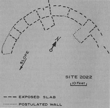
From the surface, Pueblo I sites on Wetherill Mesa are amorphous. Wall outlines, when visible at all, show for only a few feet. A ground plan of any could indicate only the area of the mound. Site 2022 on the east side of the park was surveyed by project personnel in the fall of 1959. It is a Pueblo I site on the ridge between East Canyon and Morfield Canyon, and the overburden has been removed by erosion in such a way as to reveal the outline of slab-based walls as shown in figure 73. The sherds collected at Site 2022 were all Chapin or Moccasin Gray and La Plata or Piedra Black-on-white.
|
| Figure 73—Sketch map of Site 2022, a Piedra Phase site near Morfield Canyon. |
One hundred and thirty-eight Piedra Phase sites, or sites containing Piedra material, were found on Wetherill Mesa. They range from the 7,900-foot contour down to 6,500 feet (a cave site in Navajo Canyon), but 83 percent of these sites are concentrated between the 7,300-foot contour above Mug House (Site 1229) and 7,000 feet near Ruin 13 (Site 1320). This territory comprises the broadest, most level part of the mesa and the area of deepest soil. In the center of the area, east of Long House (Site 1200), the sites are nearly continuous along the main crest of the mesa, running so close together that it is difficult to separate them. Houses and trash that could be distinguished were surveyed as separate sites, but many of these were probably parts of a single community such as the great complex of Site 13 on Alkali Ridge (Brew, 1946). At least two, Sites 1664 and 1676, are definitely of that type. The latter is made up of two lines of house mound, the longer being a 350-foot curving line of rooms. An exceptional trash mound, 60 feet wide and 3 feet deep, fronts this ruin.
The flat top of the mesa was the preferred ground for building, 91 percent of the sites surveyed being located there. One was found on a talus slope, two in the canyon bottoms, and nine in caves. There was probably more use of caves than the survey figures indicate. A pithouse found in the recent excavations in Long House was not suggested by any surface features or by the original sherd collections.
With 7 feet as the average length of a Pueblo I room in excavated sites, the 41 pure Piedra Phase sites gave an estimate of 8 rooms in the average site of this period. By multiplying the total number of sites we reach a figure of 1,104 rooms. From the ephemeral nature of the flimsy structures, from the period's span of 150 to 200 years, and from the fact that nearly all sites show evidence of burning, we can suppose that not all rooms were occupied simultaneously. The negative factor is probably outweighed, however, by the equally valid supposition that a greater number of Piedra sites were missed by the surveyors than were those of any subsequent phase. The archeological remains are usually comparatively insignificant, they are frequently covered by brush or duff, and the sites were often reused and concealed by later builders.
Dates for this phase of development are estimated from A.D. 700 to 900.
I have followed Reed in using the name Piedra for the phase because the predominant decorated pottery seems to have been strongly influenced from the southeast. From architecture and village plan, the Piedra Phase of Mesa Verde might equally well take its name from the contemporary Abajo Phase of Alkali Ridge (Brew, 1946), where the decorated ware is Abajo Red-on-orange. In speaking of the Pueblo I villages he excavated on Chapin Mesa, O'Bryan (1950, p. 105) wrote that they "appear to be a convincing blend of the characteristics of the Abajo Phase to the northwest, and the La Plata Phase to the southeast." I assume that by "La Plata Phase" he here referred to the Pueblo I sites excavated by Morris in the drainage of the La Plata River. On the basis of the blend, he proposed that the local material be assigned to the Chapin Mesa Phase.
Mesa Verde does appear to have been on the fringes of two hearth areas at this time, to have been marginally both Piedra and Abajo. According to pottery the balance is in favor of the Piedra Phase, but it is likely that sites can be found on the mesa which could be logically assigned to the Abajo focus. Site 1553, a Pueblo I site of an estimated 20 rooms west of Step House, has, on the surface of the trash mound, more Abajo Red-on-orange than black-on-white types. It is atypical but it is there. Until it can be demonstrated by more excavation that the Pueblo I villages of Mesa Verde represent a cultural entity markedly different from those to the east and west, there is little justification in assigning them to a phase or focus distinctive of Mesa Verde.
Piedra Phase sites recorded on Wetherill Mesa are (map 5):
1109
1112
1117
1178
1200
1205
1279
1303
1331
1391?
1452
1458
1464
1466
1470?
1472
1473?
1487?
1502
1544
1548
1549
1552
1553
1554
15551556
1557
1559
1562
1563
1565
1566
1571
1572
1578?
1582
1583
1584
1590
1591
1596
1598
1609
1610
1613
1614
1615
1616
1617
1619
1620
1621
1623
1624
1626
1627
1628
1629
1630
1631
1632
1633
1634?
1635
1638
1639
1642
1643
1644
1646
1647
1648
1649
1650
1651
1653
1655
1656
1657
1664
1665
1666
1667
16681672
1673
1675
1676
1685
1688
1697?
1705?
1717
1723
1724
1725
1733
1756
1762
1770
1772
1777
1778
1781
1785
1786
1790
1793
1795
1796
1797
17981805
1808
1809
1820
1821
1822
1823
1824
1825
1827
1833
1843
1844
1845
1846
1847
1849
1850
1851
1855
1863
1864
1867
1869
1900
ACKMEN PHASE
The Pueblo II period has always been the most hazily defined, or has covered the widest range of architectural types and has involved a long span of time in the Pueblo area. Various students have included in the period all developments from conversion of the pithouse to a true kiva and residence in small surface pueblos of rough masonry to and through life in the compact unit pueblos described by Prudden (1905). Morris in 1939 demonstrated that the Prudden-type house was late and was contemporary with the finest of the great pueblos of Pueblo III times. What is left between Pueblo I and Pueblo III after the removal of unit pueblos still consists of considerable development and change in material culture which, under the Gladwin system, has been labeled the Mancos Phase. Morris, dealing with the same material as that described for the Mancos Phase but using the Pecos classification, divides the phase, defining as Pueblo II the beginning of the true kiva, the earliest crude masonry, and the beginning of indented corrugated pottery. Most of the Mancos Phase of Gladwin, O'Bryan, and Reed, by Morris' definition would be Pueblo III. It is Morris' Pueblo II, a short but distinctive period, that is here defined as the Ackmen Phase. It is composed of the first century of the old Mancos Phase, or the earlier half of Pueblo II as defined by Watson (1950), and should date roughly from A.D. 900 to 975 or 1000. It equates culturally with the Red Mesa Phase of the Chaco area.
Brew (1946, p. 94) first suggested the division and the name on the basis of Martin's Site 1 in the Ackmen-Lowry region (Martin, 1938). The small house at Site 1 is of rough, slab-based masonry. A kiva with no southern recess has its roof supported by posts rather than pilasters of masonry. A trough metate and much Cortez Black-on-white and squiggle-hachured Mancos Black-on white pottery was found at the site. Tree-ring dates of 855 to 872 were published for the site (Martin, 1939). I suspect that those dates will prove to be a little early for the phase. Site 4 in the vicinity exhibited like traits.
A typical site of the phase on Wetherill Mesa consists of a few contiguous rooms in a straight line, constructed of posts and adobe or more often of a crude masonry of unshaped rock. To quote Morris (1939, p. 34): "Previously mud had been regarded as the mass, and such stones as were tucked into it were more or less fortuitous additions to its bulk. Now, however, stone came to be regarded as the substance and mud only as a filler." The kiva is circular and equipped either with post roof supports or masonry pilasters, is not always masonry lined to the full height of the wall, and lacks the southern recess of later phases. It is placed well to the front (in a southerly direction) of the rooms and does not form an integral part of the house. Trash mounds are usually well-defined areas to the south of the kiva in distinction to the sheet trash of earlier times.
Ackmen Phase pottery is distinguished by the first manufacture of Mancos Corrugated ware in the form of wide mouthed jars, often equipped with vertical loop handles. Mancos Gray forms a smaller percentage of the utility ware but was manufactured during this phase only. Cortez Black-on-white, the predominant decorated ware, is also almost exclusively confined to the phase. Mancos Black-on-white appears in its earlier design styles: squiggle hachure, pendant triangles, and checkerboards. Bowls are deep with straight sides; dippers have strap or half-gourd handles; pitchers are more common than jars. La Plata Black-on-red forms a small percentage of the decorated ware.
Other items of material culture are apparently unchanged. Trough metates are still in use. Skull deformation, which had its inception in the preceding phase, is now universally practiced.
The earliest house at Site 16 on Chapin Mesa, excavated by Lancaster and Pinkley (1954), is an example of an Ackmen Phase site. The first house, a post-and-adobe structure, was associated with an unlined kiva with four posts used as roof support. The excavators estimated its date as about A.D. 900. A subsequent occupation was in a small Mancos Phase pueblo. The association of sherds with a specific structure was impossible because of the nature of the site, but much of what was later described as Cortez Black-on-white was found at the site and illustrated. I would expect that it was derived mostly from the post-and-adobe village, an early Ackmen Phase site.
Another excavated example of an Ackmen Phase house on Chapin Mesa is Site 102 (O'Bryan, 1950). A two-room house of a combination of crude masonry, slabs, adobe and wattle-and-daub is associated with an unlined kiva with masonry pilasters but no southern recess. A date of 947 was obtained from the kiva. The sherds from the sites were identified as Mancos Black-on-white, but many of the Mancos sherds illustrated in the report are Cortez Black-on-white, a type not previously described.
Morris (1939) excavated no Pueblo II sites completely, but beneath Building I, Site 39, at the confluence of Barker Arroyo and the La Plata River, he found the remains of walls of cobble masonry of undetermined extent. The walls were apparently associated with a kiva, lined with rough cobble masonry but again with no southern recess. Four of the five vessels pertaining to this early occupation of the site were Cortez Black-on-white; the fifth, unclassifiable, could be either Cortez or Mancos. This is one of the few sites which Morris was willing to attribute to Pueblo II times. It could well be classified as an Ackmen Phase dwelling as described here.
On Wetherill Mesa 208 sites of the Ackmen Phase were surveyed. The sites are smaller than those of the Piedra Phase and more widely distributed. They average an estimated six rooms in size, by the method of arriving at a figure described above for the Piedra Phase. Only 68 percent of the sites fall in the area of mesa-top concentration between Mug House and Ruin 13. Nine of the sites were in caves; 27, or 13 percent, occupied positions on the talus slopes or in the canyon bottoms.
Surface characteristics of an Ackmen Phase site on Wetherill Mesa often differ little from those of the Piedra Phase. When the building was of jacal or adobe, only the pottery will indicate the later phase. More often, however, the rock that appears as small spalls on the earlier mound is, in the Ackmen Phase, larger, fist-sized fragments—remains of masonry walls, not stone inclusions in adobe. The house mounds tend to be deeper and, if occupied for any length of time, are fronted by a mounded concentration of trash. A faint depression marking the presence of a kiva is sometimes apparent but more often lacking. A pit unlined with masonry probably will collapse more readily and rapidly fill to a level surface. Rarely does a house mound reach 2 feet in depth or show traceable wall outlines. Examples given below are exceptional in that respect and are probably larger than the average site.
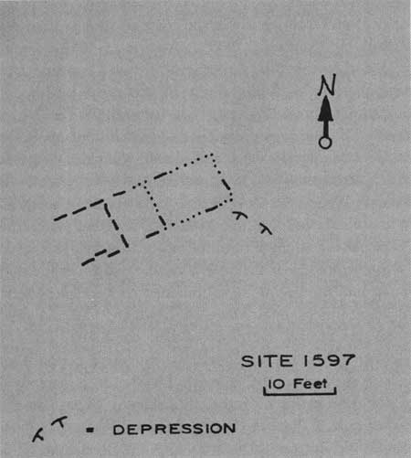
Site 1597, on the mesa between Long House and Jug House, was a three- or four-room house of slab-based masonry of small unshaped stone. A shallow depression may mark the site of a kiva. Sherds from the trash mound include Mancos Black-on-white, Cortez Black-on-white, Mancos Corrugated, and Mancos Gray (fig. 74).
|
| Figure 74—Sketch map of Site 1597, an Ackmen Phase pueblo on Wetherill Mesa top between Long House and Jug House. |
Site 1399, a pueblo of about eight rooms, is built around large fallen boulders, sections of collapsed cliff wall, on the talus slope in Bobcat Canyon (fig. 75). Walls are of slab-based rough masonry. Mancos Corrugated and Mancos Black-and-white sherds predominate; Cortez Black-on-white and Mancos Gray are present.

|
| Figure 75—Sketch map of Site 1399, an Ackmen Phase site on talus slope in Bobcat Canyon. |
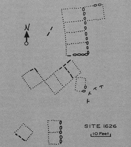
Site 1626 is an irregular arrangement of about 15 rooms on the east side of the mesa south of Step House. It was built of rough masonry, some of it based on slabs. A kiva depression is faintly visible at the southeast side of the house. Trash is extensive but scattered (fig. 76).
|
| Figure 76—Sketch map of Site 1626, an Ackmen Phase pueblo near Step House. |
Ackmen Phase sites on Wetherill Mesa are (map 6):
1102
1104
1107
1123
1125
1130
1134
1151
1153
1154
1157
1158
1159
1160
1162
1163
1172
1176
1177
1178
1179
1181
1182?
1205
1229
1243
1244
1254
1303
1306
1320
1330
1331
1334
1337
1391
1399
1403
1412
14131416
1417
1426
1428
1432?
1436
1452
1453
1458
1459
1464
1466
1471
1478
1505
1520
1522
1523?
1525?
1531?
1533
1541
1547?
1548
1552
1553
1557?
1558
1561
1562
1563
1565?
1566
1569?
1570?
1571
1572
1573
1577?
1582
1583
15841590
1591
1595
1596
1597
1603
1604
1605
1606?
1607?
1609
1610
1611
1616
1617
1619
1620
1623
1624
1626
1627
1628
1629
1630
1631
1632
1633
1637?
1639
1642
1643
1645
1649
1650
1651
1653
1654
1655
1658
1659
1661
16621667
1668
1672
1673
1676
1678
1679
1682
1684
1685
1686
1687
1688
1689
1691
1693
1694
1698
1700
1720
1723
1724
1725
1733
1739?
1744
1746
1748?
1749?
1750?
1751?
1752
1753
1754
1755
1756
1757
1760
1762
1764?
1766?
17691770
1771
1774
1775
1776
1779?
1780
1781
1785
1786
1789
1790?
1791
1792
1795
1796
1798
1810
1815
1817
1818
1821
1822
1826
1827
1828
1830
1831
1832
1838
1842
1844
1845
1846
1847
1852
1854
1860
1862
1870
1875
1879
MANCOS PHASE
After the crude masonry of unshaped rocks of the Ackmen Phase, improvement in masonry and elaboration of building techniques were rapid. In the Mancos Phase some houses were still built of unshaped stone—once a technique was learned it was not forgotten, as we find poor masonry and wattle-and-daub in late Pueblo III construction—but generally walls were better built. Rock was selected with more concern for uniformity and was laid in courses rather than at random. Blocks were often given a rough shaping with a hammerstone, a common practice being to work the four sides of a flat rock by spalling back the edges to get a beveled or wedge cross section like that on a bifacially flaked chopper or scraper. Some walls were based on large upright slabs, heavier and more massive than those of the earlier phases, as the walls they supported became thicker. The first limited use was made at this stage of compound and double walls, sometimes rubble cored or rubble filled and capable of carrying greater weight than the earlier simple wall. The size and shape of the houses were little changed. They were still of one story and usually were a single or double row of up to 12 rooms laid in a straight line, though a short ell was built onto the end of some houses. Kivas were still in front of the houses but were drawn closer, not yet part of the house but immediately adjacent. They were equipped with masonry pilasters, and were usually lined with masonry from floor to banquette level if not all the way to the roof.
An addition to the list of architectural traits in the Mancos Phase may be the circular, surface structure known locally as a tower. Towers were usually adjacent to a kiva and were seemingly of an esoteric nature. In this phase they were probably never more than one story.
Mancos Black-on-white is the decorated pottery of the phase, with emphasis on the use of straight-line hachure between parallel lines. Cortez Black-on-white is no longer made. The wide-mouthed, straight- or slightly flared-rimmed Mancos Corrugated is the culinary ware. The troughed metate is replaced with the slab metate used in a bin, a type which remained unchanged through later phases. The side-notched projectile point was introduced (Lancaster and Pinkley, 1954, p. 42).
The phase dates from A.D. 975-1000 to 1050-1075.
No purely Mancos Phase site, uncomplicated by occupation during other phases, has been excavated in the Mesa Verde area. Unit Pueblo I at Site 16 on Chapin Mesa (Lancaster and Pinkley, 1954), partly overlying the post-and-adobe Ackmen Phase site referred to above, is a typical Mancos Phase house. A three-room house of chipped-edge masonry lies 3 feet behind a six-pilaster kiva, which is lined with masonry from floor to the top of the banquette.
Two of the buildings excavated at Site 41 by Morris on the La Plata River contained Mancos Phase components (Morris, 1939). Under Building III lay thin walls of rough masonry associated with a partially lined, four-pilaster kiva. Pottery associated with the older house was Mancos Black-on-white and Mancos Corrugated. The original seven-room nucleus of Building VII, also at Site 41, was of cobble masonry fronted by a kiva which was unexcavated. Associated pottery was "early Pueblo III, pre-Mesa Verde sherds."
At Lowry Ruin, Martin (1936) reckoned the four rooms which were first in construction, and around which the larger Pueblo III pueblo was constructed, to have been a Pueblo II house. The masonry is good and Chaco like. Five beams supplied a cutting date of A.D. 1090, but Martin believed they represented a later remodeling and estimated the original construction date to have been closer to 1050. This early house might well fit into the Mancos Phase, but unfortunately the pottery associated with its first occupation is impossible to determine.
In surface appearance the smaller Mancos Phase sites on Wetherill Mesa can often be distinguished from those of other phases only when there is a considerable quantity of pottery. The presence of Mancos Black-on-white and the absence of Cortez or Mesa Verde types are good indications. Typically there is more depth of house mound than on earlier sites with often enough walls standing in the rubble to enable one to trace outlines. Coursed masonry of scabbled rocks is often exposed for a few courses and even when fallen the chipping on individual rocks is apparent. Kiva depressions are more frequently visible than on Ackmen Phase sites. Trash mounds, even in front of two- or three-room houses, are often well concentrated and of some depth. The sites have the same average size—six rooms—as in the preceding phase but are fewer and still more widely scattered. Surveyed sites containing a Mancos component numbered 185 in all, and 166 on Wetherill Mesa with 59 of that phase alone.
An increased use of caves and talus slopes is shown. Sixteen percent of the sites were caves and 36 percent were located on the talus below the cliffs. Because of subsequent use it is certain that there are many caves with a Mancos Phase occupation which were not so noted. Current excavations in Mug House reveal a Pueblo II stratum in the trash not indicated on the surface.
Four representative Mancos Phase sites on Wetherill Mesa will be discussed briefly. Site 1633 (fig. 77) on the ridge east of Bobcat Canyon in a characteristic L-shaped pueblo of seven or eight rooms and a kiva. The masonry is of chipped-edge stone. Sherds in the scattered refuse run from Piedra Phase types through Mancos Black-on-white and Mancos Corrugated.
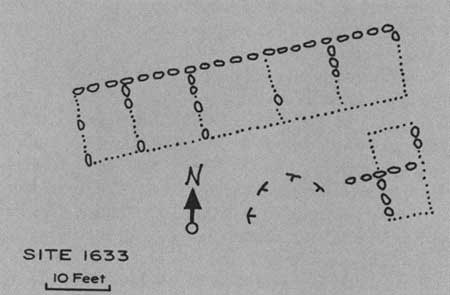
|
| Figure 77—Sketch map of Site 1633, a Mancos Phase pueblo on top of mesa south of Step House. |
Site 1141 (fig. 78) consists of terracing or retaining walls about a kiva on the talus in upper Rock Canyon. Such walls are common from the Ackmen through McElmo Phases and may have been built to support level soil on which to build jacal structures. The kiva and considerable trash indicate a permanently occupied site and not a seasonal farmhouse. Sherds are predominantly Mancos Black-on-white and Mancos Corrugated. Two axes and a plain gray seed jar were also picked up on the surface. Site 1734 is in a similar location on the talus in Long Canyon near the south end of the mesa. It is built of chipped-edge masonry, some of it slab-based, around large boulders, and it consisted of perhaps three rooms but no kiva (fig. 79). One of the rooms was built on top of a boulder; the others were at its base. The same Mancos Phase types of sherds were present.

|
| Figure 78—Sketch map of Site 1 141, a Mancos Phase site on talus slope in Rock Canyon. |

|
| Figure 79—Sketch map of Site 1734, a small Mancos Phase house on talus near south end of mesa. |
A three- or four-room cliff house, Site 1706, is built on two sides of a piece of collapsed cave ceiling in a small cave in Rock Canyon near the south end of the mesa (figs. 80, 81). The masonry, some of it double wall, is of carefully selected split rock. All sherds were of Mancos Corrugated or Mancos Black-on-white.
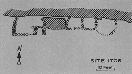
|
| Figure 80—Sketch map of Site 1706, a Mancos Phase cliff dwelling on Rock Canyon side of Wetherill Mesa. |
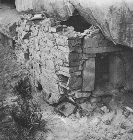
|
| Figure 81—Room at west end of Site 1706. |
Kiva-associated towers were found at two pueblos showing no materials representative of a later phase. Site 1101, on the narrow ridge between Long Canyon and its West Fork, is a shapeless agglomeration of 15 rooms built of coursed masonry in which the stones have had some primary shaping. One room at the east side is of large, upright slabs. A large rock-lined kiva sits close to the house with rooms adjacent to two sides. At the southwest side of the kiva—the side away from the house—is a circular structure of small slabs; part of its wall is formed by a section of kiva wall. The proximity of the kiva to the house is the only suggestion of a McElmo Phase trait. The pottery is Mancos Black-on-white and Mancos Corrugated. It seems to be a late Mancos Phase house with an incipient one-story tower. Site 1573 is a pueblo of scabbled masonry on the mesa above Step House. About 12 rooms are built in a single line with a kiva depression in front of one end. The walls of a tower are outlined between the kiva and the west end of the house and touching both. A well-defined trash mound lies downslope; a large collection of sherds is mostly Mancos Black-on-white and Mancos Corrugated.
|
| MAP SEVEN |
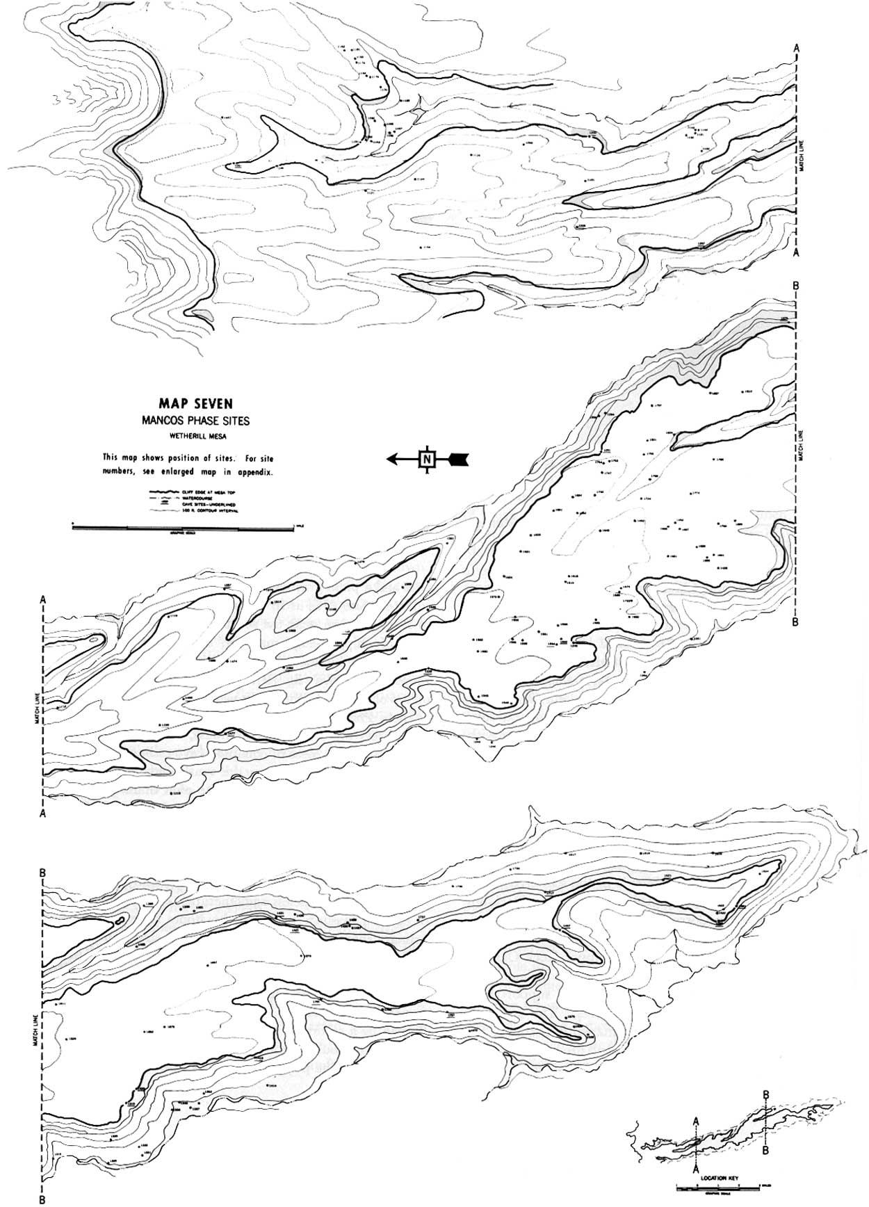
Mancos Phase sites surveyed on Wetherill Mesa are (map 7):
1101
1104
1113
1119
1121
1124
1126?
1130
1131
1132?
1141
1143
1144?
1146?
1149
1150
1151
1153
1154
1157
1158
1159
1160
1162
1163
1164
1169
1170?
1176
1177
1181
1191
1202
12051207
1210
1220
1229
1243
1244
1249
1251
1254
1257
1270
1281
1282
1291
1294?
1306
1315
1319
1320
1329?
1331
1332
1336?
1337
1338?
1339
1340?
1344
1353?
1369
1375
1391
14011405
1414?
1421
1426
1428
1430
1431?
1436
1437
1447
1452
1453
1468
1474?
1477
1490
1492
1499
1500
1503
1504
1509
1514
1517
1518
1519
1521
1523
1524
1528?
1529
1536?
1538?
15401545?
1546?
1550?
1551
1560
1573
1579?
1582
1589
1590
1591
1593?
1594
1595
1596
1599?
1600
1603
1610
1618?
1624
1631
1633
1645
1651
1652
1654
1681?
1685
1687
1689
1690
1691
16991700
1701?
1703
1706
1707?
1717
1722
1724
1732?
1734
1735
1737
1747?
1753
1754
1758
1765?
1774
1780
1797
1801
1804
1807?
1810
1811
1826
1852
1857
1872
1875
1876?
1878?
McELMO PHASE
In the late 11th century the long cultural development north of the San Juan, through accumulated impetus, reached a stage of comparative architectural sophistication. The small but substantial pueblos and the development of coursed masonry of shaped rock during the Mancos Phase provided the basis to evolve the larger and more complex pueblos of the McElmo. The kiva, now completely lined and equipped with the enlarged southern recess of the typical Mesa Verde keyhole-shaped kiva, was made an integral part of the house. The kiva roof and the area immediately around it became a patio by surrounding it on two or more sides by rooms or by wing walls. Towers were more common and often of two stories. Compound walls of shaped rock with both surfaces faced became the rule, particularly in pueblos exposed to the weather. Additional treatment of stone appearing during this phase was the finishing of the exposed surface by dimpling with a hammer or pecking stone. Though most houses were of a single story, some were multistoried structures; communities of 30 or more rooms were built, though pueblos of 10 to 15 rooms were more common.
The McElmo Phase ushers in the true Pueblo III period in the area. The Pecos classification defines Pueblo III as the period of large communities. Settlements were certainly larger than in preceding phases, but it would be an error to think of such compact communities as Aztec, Yucca House, and Pueblo del Arroyo as being typical housing for the times. Large pueblos were not developed before Pueblo III times but were still exceptional. Many more sites contain only one or two kivas and a dozen or so rooms, and even smaller sites were not uncommon. But the tendency for kiva groups to cluster into one pueblo had started.
Other changes from the Mancos Phase are confined to the pottery. Mancos Black-on-white is still the dominant decorated ware on McElmo Phase sites with the addition of the carbon-paint variety discussed earlier as Wetherill Black-on-white. McElmo Black-on-white appears in both of its variations but in minimal quantities. Mancos Corrugated jars with wide mouths and a slight flare to the rim are still manufactured.
Gladwin used One Clan House on Chapin Mesa as the type site for his first definition of the McElmo Phase. One Clan House is a small unit of 10 to 12 rooms on three sides of a kiva, which was enclosed on the south side by a low wall. The site was excavated by Fewkes, who disposes of it in two brief paragraphs (Fewkes, 1923). A collection of sherds from the site made by Lancaster, in the course of the archeological survey of Chapin Mesa, contains classic Mesa Verde Black-on-white—in fact, nearly half the decorated sherds collected. Though the architecture is right for the McElmo Phase, the site was occupied into the Mesa Verde Phase. Pipe Shrine House nearby, also excavated by Fewkes in 1922, is as representative of the phase architecturally as One Clan House, and is recorded in a little more detail. Mancos Corrugated and Wetherill Black-on-white pottery are illustrated as coming from the house and the trash in front of it (Fewkes, 1923.)
O'Bryan (1950) enriched the description of the phase after his excavation of Site 34. The pueblo is a large compound of five kivas, a tower, and about 50 rooms, at the head of Soda Canyon just east of Chapin Mesa. Several accretions to the original structure had been made, with its final use in the Mesa Verde Phase.
Lowry Ruin (Martin, 1936), with its long occupation, contained much McElmo Phase material. Much of the pottery illustrated from its rooms appears to be Wetherill and McElmo Black-on-white. But this large ruin, too, was also occupied in the later Mesa Verde Phase and probably received its ultimate additions and remodeling at that time.
On the La Plata at Site 41 (Morris, 1939) Buildings V and VII are late Pueblo III structures which, like Lowry Ruin and Site 34 on Mesa Verde, contain earlier material that could be attributed to the McElmo Phase. Two mounds at the same site, Buildings XII and XIV, however, appear to have had their last occupation during the McElmo Phase. Wetherill and McElmo Black-on-white sherds and vessels predominated; no classic Mesa Verde pottery was found in the ruins except accompanying the burials. The excavator believed the latter to have been placed there by occupants of later buildings nearby after the abondonment of the sites in question. The two buildings had been used as a source of construction stone during late Pueblo III, and had been badly torn up by pothunters. They were only partially excavated by Morris.
Except for the incomplete record of Buildings XII and XIV in the La Plata Valley we have no excavated site in the area in which the final construction was during the McElmo Phase and which can serve as an adequate type site. Such ruins do exist, I believe, and occur in greater numbers on the Mesa Verde, where most of the subsequent population was living in caves, than in the surrounding valleys where the same sites were more often used continuously until the area was evacuated. There are several likely prospects on Wetherill Mesa. Typical examples are illustrated by rough sketches in figure 82, and will be described briefly.

|
| Figure 82—McElmo Phase sites. |
Site 1801, approximately a half-mile east of Long House, is built on the crest of a gently sloping ridge. The house is a small block of perhaps eight rooms with a single kiva in front. The masonry is of large, blocklike scabbled stone. The kiva is partially enclosed by a wall built along the east and south sides. Pottery from the site included Wetherill and McElmo sherds but nothing more recent. The pottery from this site has been covered in more detail under the discussion of McElmo Black-on-white. Reference may be made to table 10 for a complete count of identifiable sherds. A few Cortez Black-on-white sherds, a large trough metate, and a trash mound 2 feet in depth and measuring 40 by 60 feet indicate a fairly long occupation culminating during the McElmo Phase.
In the center of the mesa top between Step House and Long House. lies Site 1610, a larger pueblo of an estimated 25 rooms, possibly with some of two stories at the rear. The two kivas are built in close to the house with one joined to the rooms to the east. A trace of a low wall to the south suggests that the kivas were fully enclosed in a plaza. Wetherill Black-on-white sherds were picked up on the deep trash mound just south of the front wall along with the slightly everted rims of late Mancos Corrugated.
Site 1753 near the east edge of the mesa south of Step House has an unusual crescentic arc at the rear, or north side, of the building. This shape, common in Chaco Canyon and occurring in Building IV of Site 33 near Johnson Canyon about 12 miles to the southeast, is found at only one other site on Wetherill Mesa built after the Piedra Phase, Site 1654, a Pueblo II structure. Nine rooms of chipped-edge masonry nearly surround a single kiva. The sherds again include Mancos Corrugated, Wetherill and McElmo Black-on-white but no Classic Mesa Verde.
A three-kiva unit of 25 to 30 rooms, Site 1595, lies to the southwest of Step House near the west edge of the mesa. The mound is about 3 feet deep, of irregular E-shape. The masonry is of well-shaped rock, some stones possibly finished by pecking, The same sherd assemblage was present.
Site 1780 presents a similar combination of architecture and pottery. The masonry is of finished rock, and the unit includes a low tower at the southwest corner adjacent to the kiva. Each of the above sites was settled prior to the McElmo Phase but shows no evidence of subsequent use. Large concentrations of refuse lie before all sites but one. Site 1780, the last mentioned, is located on a small point above a sharp pitch of ground; sheet erosion has carried away and scattered the trash.
Though the unit pueblos are the distinctive architectural feature of the phase, the movement into caves which started during the Mancos Phase increased, with 30 percent of the McElmo sites on Wetherill Mesa located in the cliffs. The small houses built around large boulders on the talus are still common, and a new site location used during this period is at the foot of the upper cliff at the top of the talus. Here houses were built against the bluff but without the protection of an overhang. Examples of this occur at Site 1230 at the north point of the Mug House rincon and at the north end of Double House (Site 1385).
Sites recorded for the McElmo Phase are fewer and somewhat larger. Eighty-eight surveyed sites, with an average of nine rooms, could be attributed to the phase; of these 60 were on Wetherill Mesa. The low number of sites probably reflects some drop in population but is also accounted for in part by the probability that many of the McElmo sites were not recognized as such. The distinctive pottery types were not the dominant wares; in a 50-sherd collection from a small talus site consisting of Mancos Black-on-white the site might be typed Mancos Phase, whereas a 75-sherd sample might include a couple of Wetherill Black-on-white. The presence of McElmo Black-on-white is to be expected in the Mesa Verde Phase cliff dwellings, and the earlier occupation is often concealed.
O'Bryan has suggested dates of about A.D. 1050 to 1150 for the phase.
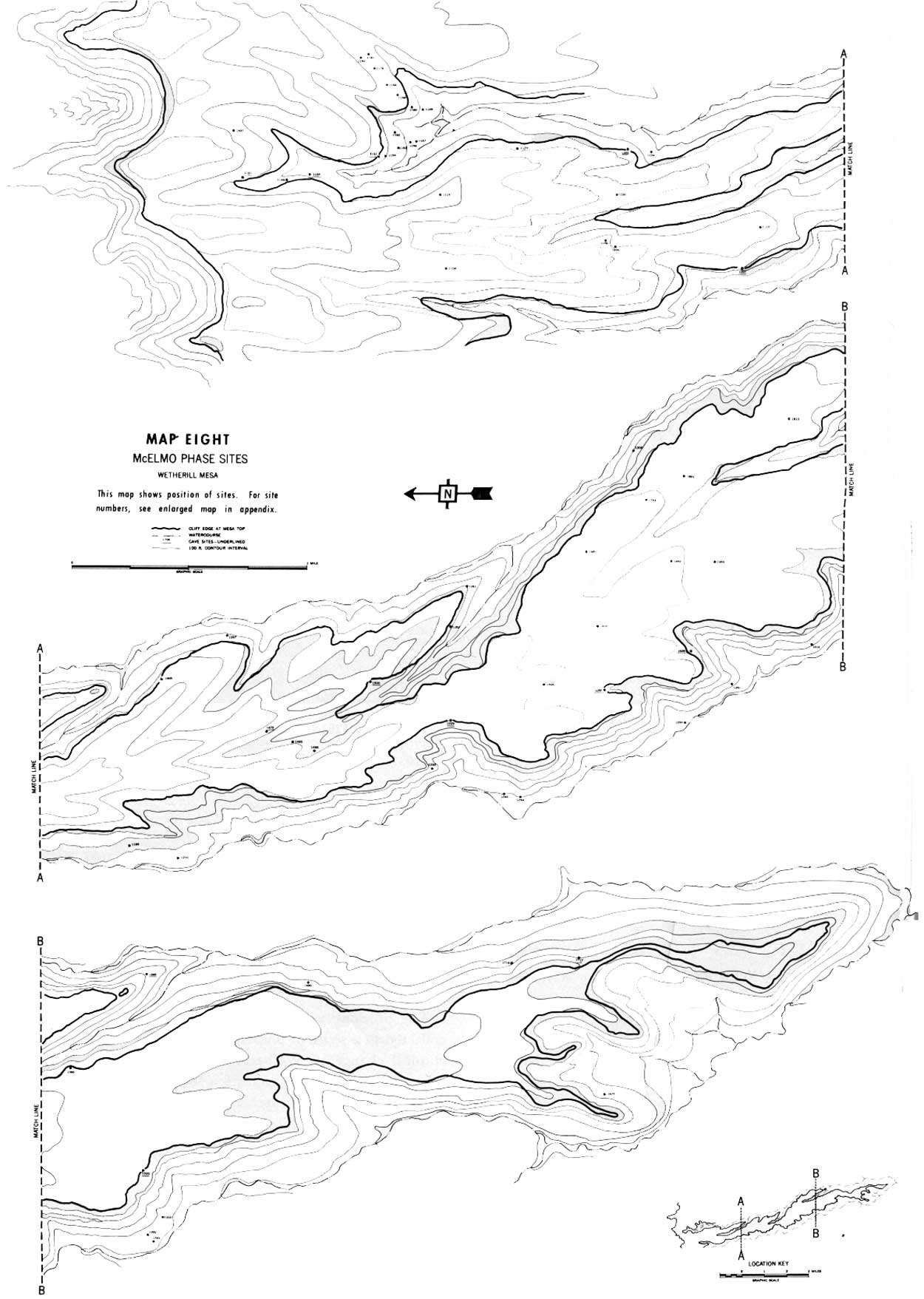
McElmo Phase sites on Wetherill Mesa are (map 8):
1100
1104
1106
1110
1124
1149
1151
1153
1154
1155?
1157
1158
1160
1162?
1164
11681169
1173
1174
1176
1180
1181
1189
1191
1202
1205
1207
1210
1229
12301243?
1244
1249
1251
1254
1257
1281
1282
1293
1306
1313?
1320
1331
13321333
1369?
1385
1391
1430
1437
1452
1453
1475?
1495
1496?
1500
15951610
1651
1681
1714?
1717
1724
1753
1780
1801
1810
1875
1905
MESA VERDE PHASE
The most notable innovation in living accommodations since the pithouse became a kiva was made in the McElmo Phase with the construction of unit pueblos and the use of finished rock in masonry. Little was added to the architecture in the Mesa Verde Phase. Some of the unit pueblos constructed earlier were added to and made larger, although in many cases it was only the "ruin" that was larger, since earlier rooms were often abandoned and filled with trash and a new wing added. It would be difficult to prove that the larger Mesa Verde ruin had ever held more people than the smaller one of a hundred years earlier. Nearly all the larger five- and six-kiva-unit pueblos in the area, however, show evidence of a late occupation. If any changes in masonry occurred, they were more a matter of degree than of style. More of the rock exhibits the technique of pecking, and more double walls were used in the later sites. I have observed no ground surfaces on building stone except in Mesa Verde Phase sites, but it is not common even then (figs. 22, 23).
The chief difference in dwellings was in their location. By this time the majority of the sites were in caves, where the limitations imposed by the configuration of the rock were frequently a more important factor in the village plan than were the inherited notions of the builder. Where the size of the cave permitted some adaptation of the unit pueblo, the grouping of domiciles about a kiva was usually followed. The placement of the kiva to the south of the house, a plan rigidly adhered to up to this time and still followed in the surface or exposed sites of the phase, was no longer so important. The shape of the cave often made it easier to place the kiva to the front of the cave regardless of the direction it faced. Perhaps this practice conditioned the builders to be less concerned about where a kiva was built, because in seven cliff dwellings encountered by the Wetherill Survey (Sites 1217, 1280, 1365, 1370, 1442, 1446, 1882) the kiva was placed north of the houses; in none of these did the conditions at the site prevent the use of the more conventional location.
Adaptation of the architecture to caves led to other small changes. Because of the protection from the weather afforded by the overhanging rock many rooms were not roofed with timbers but were built to the cave roof, which served as a ceiling, or were sometimes left open at the top of the wall. Much of the masonry in cliff sites, where there was no need to support extra stories, is not of high quality, and the need to conserve space in the cramped locations was probably responsible for the building of smaller rooms: Again it may have been the factor of space that led to the development of the square kiva. Six sites (1195, 1217, 1293, 1448, 1449, 1885) contained rectangular kivas.
The towers that appeared with the Mancos Phase as low structures were often of two or three stories in the Mesa Verde Phase (figs. 83, 84). Most are part of a house unit, usually near a kiva and frequently connected to it by a passageway or tunnel, but many towers occur alone or with a kiva in a location isolated from any dwellings. Site 1253 in the bottom of Rock Canyon is remarkable in having the only square tower found by the survey (fig. 85). This site consists of a structure 10 feet square of double-walled, finished masonry, still standing to the height of 8 feet. The amount of rubble at its foot suggests a building of at least two stories. The tower stands at the northwest side of a kiva depression 23 feet in diameter. A low retaining wall below the kiva is the only other construction in the vicinity.
|
| Figure 83—A three-story tower. Site 1138. |
|
| Figure 84—Tower at small pueblo. Site 1139. |
|
| Figure 85—Remains of a square tower associated with a kiva. Site 1253 in the bottom of Rock Canyon. |
The pottery of the phase underwent distinct changes. McElmo Black-on-white was carried over from the McElmo Phase but Wetherill was not. Mesa Verde Corrugated, with its small mouth and everted rim shape, is diagnostic of the phase, and the shapes of the earlier Mancos Corrugated were discontinued. The easily recognized and beautifully decorated Mesa Verde Black-on-white is symbolic of this last period of pueblo occupation north of the San Juan.
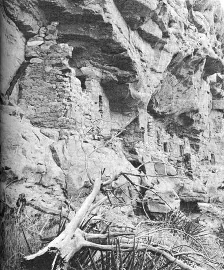
Excavated Mesa Verde Phase sites in the park itself are numerous but unfortunately are not so well recorded as we would wish; the preserved sites themselves perhaps reveal more than written records of the investigations. Nordenskiold's (1893) notes on cliff dwellings on Wetherill and Chapin Mesas afford some material. J. W. Fewkes did more work on Mesa Verde than any other archeologist; he reported on his first excavation, Spruce Tree House, in 1909, and on Cliff Palace in 1911. The Far View House excavation was treated briefly in 1917. Site 34 (O'Bryan, 1950) in Soda Canyon and Sun Point Pueblo (Lancaster and Van Cleave, 1954) are the only well reported excavations. These five ruins, though larger than the average for the period, may be considered illustrative of the phase, though the smaller Eagle Nest House in Lion Canyon across the Mancos River from the park is a more typical cliff dwelling (Morris, 191 9a).
Among the many late Pueblo III ruins excavated on the La Plata by Morris (1939), Buildings, V, VII, XV, and XVI at Site 41 are good examples of Mesa Verde Phase pueblos, as is the final construction at Lowry Ruin (Martin, 1936). Site 4 in Mancos Canyon (Reed, 1958) is more typical in size. The great pueblo of Aztec (Morris 1919b, 1924a,b, 1928) was, at least in its last occupation, a Mesa Verde Phase site. Up to Pueblo III times Aztec had been on the southern periphery of the Mesa Verde area but during this period, if not earlier, during the McElmo Phase, the realm was extended south to Chaco Canyon, where a Mesa Verde Phase occupation is found at Pueblo del Arroyo (Judd, 1959), Pueblo Bonito (Judd, 1954), and Leyit Kin (Dutton, 1938). Reconnaissance conducted by Emma Lou Davis for the Wetherill Mesa Project indicates that, as pointed out long ago by H. P. Mera (1935), this range may be extended to the east and west flanks of Mount Taylor.
The survey tabulated 153 Mesa Verde Phase sites on Wetherill Mesa, of which 100 (66 percent) are placed in the cliffs. The average number of rooms for all sites is 9, with those in the caves averaging 10 rooms and being somewhat larger than those in the open which have a 7-room average. The ratio of rooms to kivas in open sites is 1 kiva to 12 rooms, and in the cliffs is 1 to 10. Such averages may be useful, but the actual settlement picture covers a great range from the many caves containing 1 room to Long House with about 150. Over half the cliff sites contain no kiva; some have several kivas and no rooms, or very few, which may not have been secular. Site 1209 containing a tower and a kiva is several hundred feet removed from Site 1207 (fig. 86), a 15 to 20-room pueblo with no kiva; the former probably served as the ceremonial center for the community. There are other similar combinations. Sites 1218 and 1221 (figs. 87, 88), caves in the bottom of the West Fork of Long Canyon, are of 30 and 35 rooms with only 1 kiva each, whereas Ruin 12 (Site 1321) has a ratio of only 4 rooms to a kiva (fig. 89).
|
| Figure 86—Site 1207, Mancos through Mesa Verde Phases, a cliff dwelling in Rock Canyon. |

|
| Figure 87—Mesa Verde Phase cliff dwelling in the bottom of West Fork of Long Canyon. Site 1218. |
|
| Figure 88—Mesa Verde Phase cliff dwelling in bottom of West Fork of Long Canyon. Site 1221. |
|
| Figure 89—Site 1321, Nordenskiold's Ruin 12, on west side of Wetherill Mesa. |
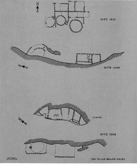
Ground plans of three representative Wetherill Mesa sites are shown in figure 90. Site 1810 is a pueblo near the end of the long ridge between Bobcat and Long Canyons. The outlines of at least nine rooms are discernible with a depth of mound suggesting that some of the rear rooms may have been of two stories. A tower is placed between two kivas, and all three structures are definitely part of the house. Masonry is of shaped rock with some chipped edge, characteristic of the Mancos Phase. Mesa Verde Black-on-white sherds are present, but many earlier sherds indicate long site occupation.
|
| Figure 90—Three Mesa Verde Phase sites. |
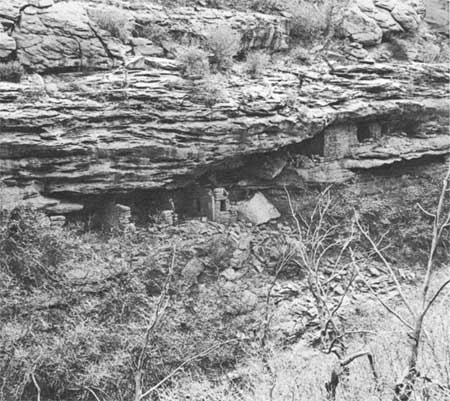
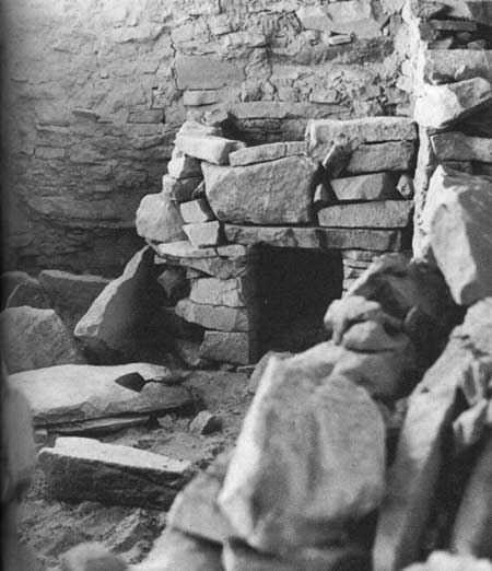
A small cliff house, Site 1446 (see also fig. 91), situated high in the upper cliff above Long Canyon, can be reached only by rope or ladder from the mesa top. The house consists of three rooms, the long one to the rear probably for storage. The largest room contains two mealing bins of upright slabs and a small, low-walled storage bin (fig. 92). The D-shaped kiva employs the cliff face for its rear wall. The masonry is substantial but of unfinished stone. The ceiling timbers and the metates had been removed, probably by other builders of the same general period. The few decorated sherds found were all Mesa Verde Black-on-white.

|
| Figure 91—Site 1446. Cliff dwelling in Long Canyon. |
|
| Figure 92—Storage bin in room corner. Bin was originally roofed with sticks. Site 1446. |
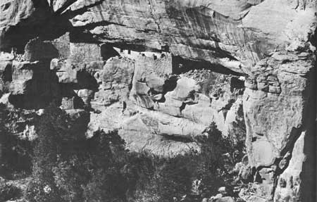
Site 1365 is in the cliff directly across Bobcat Canyon from Double House (Site 1385). The site consists of six rooms completely filling a small cave 40 feet above the talus plus a kiva and mound of house rubble immediately below built against the cliff and on the talus. Entry to the cave is now made by swinging in from the top of the cliff but when in use may have been via a ladder from the top of a two-story house on the talus. Split-level living was common. Many cliff sites are built on several small ledges within a cave or are scattered through several small adjacent caves.
Figure 93 shows a type of construction not uncommon in caves. Two juniper poles remain of the several that were laid across a notch in the cave floor near the lip to serve as floor joists. The outer timber was a sill that supported the outer wall of the room. The joists were covered with rock slabs and adobe flooring. The same technique was employed at Ruin 12 (Site 1321; fig. 94) and Daniels House (Site 1448) on Long Mesa; the logs still carry the weight of unbroken walls and floors. Masonry in the cave was mediocre and of rough-shaped stone. Two Mesa Verde Black-on-white bowls and two Mesa Verde Corrugated jars were found on the cave floor. All sherds from the slope below were of the same types.

|
| Figure 93—Timber joists laid across crack in cave floor to support floor and wall. Site 1365. |

|
| Figure 94—Timber still supporting outer wall over irregularity in cave floor. Site 1321. |
The phase dates from about A.D. 1150 to 1300.
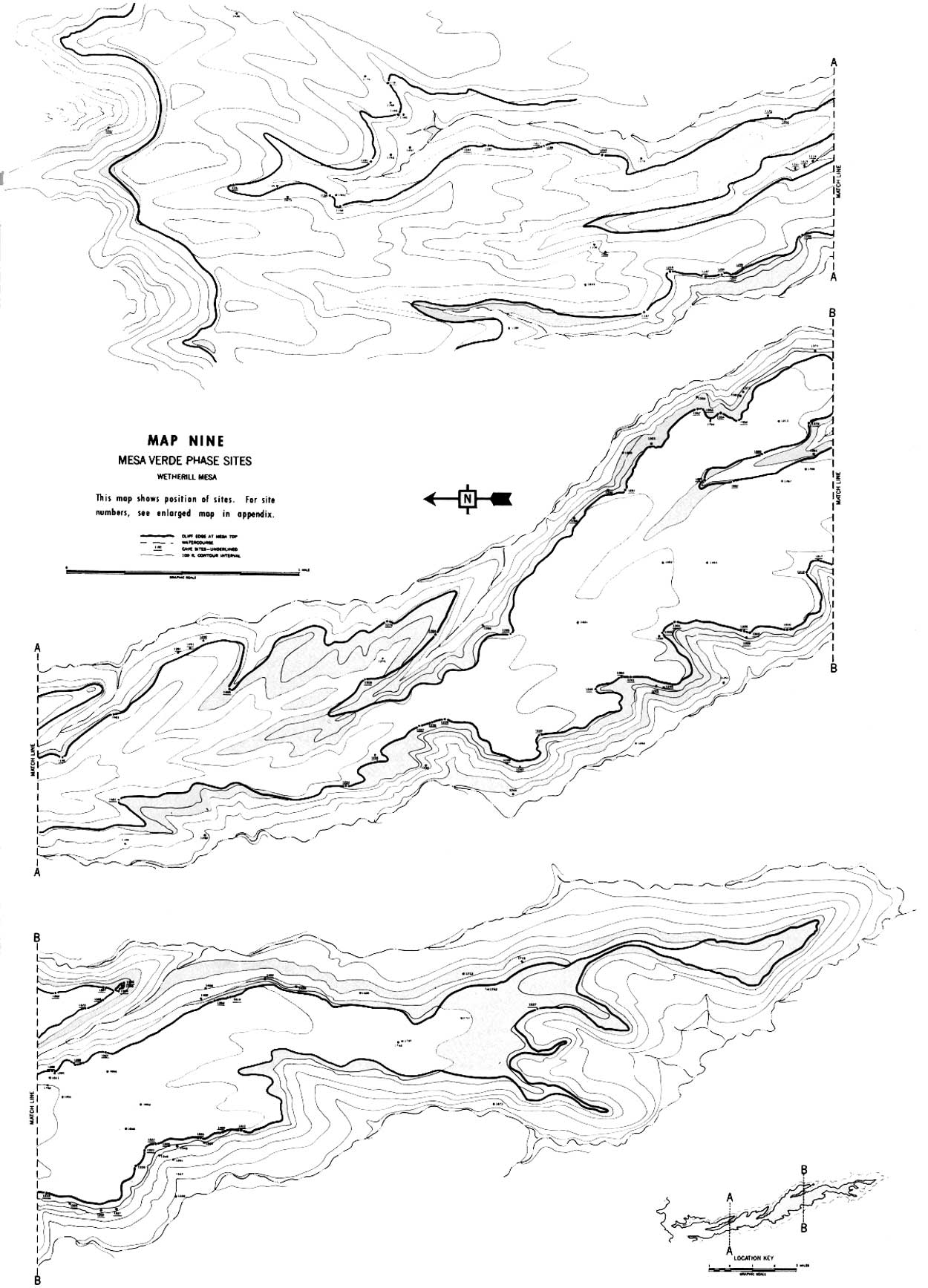
Mesa Verde Phase sites surveyed on Wetherill Mesa area (map 9):
1106
1142
1148
1149
1151
1153
1156
1157
1166
1167
1168
1174
1175
1176
1180
1187
1189
1191?
1193?
1194
1195
1199
1200
1201
1203?
1204?
1205
1206
1207
1208?
1209
1212
1213?
12161217
1218
1219
1221
1222
1224
1226
1227
1229
1230
1232
1233
1239?
1240
1241
1244
1245
1246
1249
1251
1253
1254
1260
1261
1262
1274
1275
1284
1285
1286
1288
1290
1291
1293
12951301
1302
1303
1306
1307
1308
1309
1310
1317?
1318
1320
1321
1322
1323
1325
1326
1327
1335
1343
1345
1347?
1349
1350
1351?
1354
1356
1357
1359?
1362
1363
1364
1365
1366
1367
13681370
1372
1373
1374
1381
1384
1385
1387?
1388
1390?
1391?
1396
1402?
1403
1409
1411
1419
1425
1429?
1433
1438
1439
1446
1451
1452
1453
1465
1482
1483
1500
1505
15271621
1628
1681
1712
1715
1726
1727
1728?
1729
1730
1731
1741
1742
1743
1745
1787?
1788
1792
1794
1810
1811
1833
1848
1866
1872
1874
1880
1881?
1882
1883
1901
1902
SUMMARY
The previous section related the data and materials collected to a series of phases outlining the sequences of cultural change on Wetherill Mesa. A review of the data and phase outline pictures a settlement pattern by phase and strongly indicates changes in population numbers. Little can be said at this point of a preceramic occupation except that the excavations in Site 1205 suggest that there probably was one. On the basis of the survey we cannot say much about the La Plata Phase except that it is unquestionably represented and that use probably was made of both caves and the mesa top for homesite location.
|
| MAP EIGHT |
|
| MAP NINE |
Evidence of Piedra Phase occupation is plentiful; the period may have seen the peak of population on the mesa, or very near it. A total of 147 sites with an estimated 1,176 surface rooms was recorded. The individual sites average eight rooms in size but it seems probable, as we have observed above, that frequently two or more site numbers were assigned to what was, in reality, a large community of several houses. Map 5, showing the occurrence of Piedra Phase sites, also shows a significant preference for the area of greatest width to the mesa top. It is this part of the mesa, between Mug House and Ruin 13, where the relatively level ground has the deepest deposit of red loess soil. It was the choice dry-farming area on Wetherill Mesa, and 83 percent of the Piedra Phase sites were located here. From the density of sites on this favored ground we can assume that practically all the available space in this area got some use. It was saturated from end to end.
Changes in site distribution were made during the next two centuries. If the maximum population figure had not been reached earlier, it had reached its peak with the Ackmen Phase. The 208 sites recorded with an estimated number of 1,248 rooms may not indicate an increased population but merely that more of them were found, but it seems certain that numbers diminished in subsequent phases.
Two trends are noted: a reduction in the size of house and a more scattered distribution of settlements (map 6). The average Ackmen Phase site having no subsequent occupation was of six rooms, considerably smaller than in the preceding phase, particularly if we are right in assuming that the six-room Piedra house is actually part of a larger village. No such grouping of houses is apparent in Ackmen times. The mesa top still carries most of the sites, but they are more spread out with use made of the narrow, stony ridges. The broad central section of the mesa is still the preferred area but the percentage of sites located there has dropped from 83 to 68. Pioneers not only settled the outlying edges of the mesa but, in equal numbers, built on the talus slopes. By the close of the Ackmen Phase there had been a concentrated use, by relatively high numbers of people for about 300 years, of the choice location. Generations of firewood cutting, of clearing for planting, and of cultivating must have resulted in denuded and eroded ground. Relief from population pressure and a search for new soil led some to settle in apparently less desirable locations.
The reduced number of sites found representing the Mancos Phase must certainly reflect an actual reduction in numbers of people. It is likely that a greater percentage of the substantial masonry houses were found by the survey crew than of the earlier Pueblo II houses, many of which were of wattle and daub. The spreading out, which began in the Ackmen Phase, continued with greatly increased settlement on the talus and in caves, leaving only 32 percent of the sites in the formerly choice part of the mesa, with fewer than half the houses on the entire mesa top (map 7). The development of terrace farming, in this phase or earlier, must have been a valuable addition to farming practice—check dams on the talus slope enabled a man to trap his topsoil after it was eroded from the higher ground—but the evidence of a smaller population suggests that it may not have been enough. It will be interesting to see if a study of survey material from areas adjacent to the Mesa Verde area will support a theory of the beginnings of an exodus in the Mancos Phase.
The McElmo Phase marks a reversal of the fragmentation started in the Ackmen Phase with the breaking up of the large communities. The average site contains nine rooms with many much larger. Kiva units were grouped, a tendency which continued through the last phase. The other trends, away from the mesa top and onto the talus slopes and into the cliffs, continued. The Piedra Phase hearth area on the wide section of the mesa was populated by only 10 percent of the total number of McElmo Phase sites. Over two-thirds of the houses are now in the cliffs or below them. The most popular type of settlement was a unit pueblo on the talus slope or in the canyon bottom. Most of these were on broad benches at the canyon heads or were built at the top of the talus against the cliff (map 8). Population seems to be still lower in numbers.
During the Mesa Verde Phase the drift off the mesa top continued; only 25 percent of the sites were located there, and the use of the broad, flat area had dropped to 9 percent. The use of caves climbed sharply with a correspondingly diminishing use of the talus (map 9). The Mesa Verde Phase material in the majority of mesa-top ruins is scanty and gives the impression that it was the result of short-term use of few rooms in an older pueblo or possibly even was confined to ceremonial use. The pattern shown in tables 7 and 8 of changing preferences for homesites, however, is not duplicated in site numbers and room count. The sites number more than in the previous phase, and the room count more than for any phase. I nevertheless believe that we can postulate a continued drop in population.
TABLE 7.—Changing preference percentage
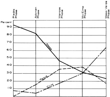
TABLE 8—Sites by phase and location, with estimated room numbers
| Phase | Total number of sites |
Mesa sites (%) |
Talus and canyon sites (%) |
Cliff sites (%) |
Estimated number of rooms |
Number of rooms in average site |
| La Plata and Piedra | 147 | 91 | 2 | 7 | 1,166 | 8 |
| Ackmen | 208 | 82 | 14 | 4 | 1,248 | 6 |
| Mancos | 166 | 47 | 37 | 16 | 996 | 6 |
| McElmo | 60 | 31 | 39 | 30 | 540 | 9 |
| Mesa Verde | 168 | 25 | 19 | 66 | 1,512 | 9 |
Because most of the sites were in protected caves, and because the country was thereafter abandoned with no further plundering for building material, the survey party could obviously make a much more complete count. We know from current excavation that Long House and Mug House had been used before the Mesa Verde Phase, although the fact was not evident as a result of the survey. It is altogether probable that in other caves the same situation exists. The figures given for the preceding phases, therefore, are probably distinctly lower than they should be. We know that caves were used in the McElmo Phase, and the material culture of the phase is difficult to distinguish if mixed with Mesa Verde trash.
Since the room count for this phase is most likely to be fairly accurate, we have for the first time some basis for a population estimate involving actual numbers rather than relative gain or loss. We know that not all the 1,512 rooms were used simultaneously. Large numbers of the rooms in the count had been robbed of roof timbers for reuse elsewhere. In many sites only a hard-packed adobe floor and scattered adobe mortar remain of an entire room razed for the salvage of building material. Others have a fill of Pueblo III trash. An estimate of 1,000 rooms with concurrent use would probably be generous. In seven representative cliff dwellings on Wetherill Mesa an average of 27 percent of the rooms are small cubbyholes thought to have been for storage. If we apply the same percentage to the estimated number of rooms of contemporary use, we are left with 730 rooms to provide sleeping quarters. We have no reliable data on which to base an estimate of the size of a family. The birth rate may have been high, but it is certain that the infant mortality rate was high also. A family might have two to four children under the wing at a time but some rooms were probably occupied by a widow, widower, or surviving couple whose children had set up housekeeping for themselves. The size of the rooms would preclude a large number of recumbent bodies unless sleeping was in shifts. If we allow an average of 1 or 2 to a room, our figures run from 730 to 1,460. I feel that the lower figure would be a safer estimate, and even this figure represents a heavy population for an area of 10 sections of marginal land.
The Chapin Mesa Survey and a survey of a smaller area between White's and Morfield Canyons on the east side of the park revealed a site density comparable to that on Wetherill Mesa, as did Reed's survey in Mancos Canyon (Reed, 1958). A reconnaissance of the southern half of Wildhorse Mesa and more casual inspection of the rest of the mesa would indicate that sites are not unusually thickly concentrated on Wetherill. The Wetherill survey covered a little less than a tenth of Mesa Verde north of the Mancos River. If a population of 730 for Wetherill Mesa is hard to accept, a projected figure of 7,300 for the Mesa Verde leaves one even more dubious.
Of course, the results of the survey can only speak for events within the area surveyed. Arthur Rohn's analysis of the Chapin Mesa Survey will afford comparative data, but the Mesa Verde is, again, but a small part of the cultural area to which it gave its name. The entire area from the La Plata River to the Abajo Mountains and from the San Juan to the Dolores is generously sprinkled with Pueblo III ruins. Mesa Verde Phase Indians in the Montezuma Valley at the northern foot of the mesa were living in unit pueblos and had no caves to go to. Whether the population decline, from the Ackmen Phase onward, that occurred on Wetherill Mesa was duplicated in surrounding sections of the Mesa Verde area may be shown by future surveys.
| <<< Previous | <<< Contents>>> | Next >>> |
archeology/7a/survey6.htm
Last Updated: 16-Jan-2007