On the completion of the work of excavation and
repair of Cliff Palace, in the Mesa Verde National Park, in southern
Colorado, in charge of the writer, under the Secretary of the Interior,
he was instructed by Mr. W. H. Holmes, then Chief of the Bureau of
American Ethnology, to make an archeologic reconnaissance of the
northern part of Arizona, where a tract of land containing important
prehistoric ruins had been reserved by the President under the name
Navaho National Monument. In the following pages are considered some of
the results of that trip, a more detailed account of the ruins being
deferred to a future report, after a more extended examination shall
have been made.a Mention is made of a few objects collected, and
recommendations are submitted for future excavation and repair work on
these remarkable ruins to preserve them for examination by students and
tourists. As will appear later, a scientific study of them is important,
for they are connected with Hopi pueblos still inhabited, in which are
preserved traditions concerning the ruins and their ancient
inhabitants.
aThe author's first visit to these ruins was made in
September, 1909, and he returned to the work in the following May. A few
notes made on the latter trip on rums not observed during the former are
incorporated in this report.
The present population of Walpi, a Hopi pueblo, is
made up of descendants of various clans, whose ancestors once lived in
distant villages, now ruins, situated in various directions from its
site on the East mesa. One of the problems before the student of the
Pueblos is to locate accurately the ancestral villages, where these
clans lived in prehistoric times. From an examination of the
architecture of these villages and a study of the character of secular
and cult objects found in them, the culture of the clans that inhabited
these dwellings could be roughly determined. The culture at any epoch in
the history of the clan being known, data are available that may make
possible comparison and correlation with that which is still more
ancient: in other words, that may add a chapter to our knowledge of the
migrations of the Hopi Indians in prehistoric times.

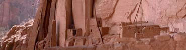
Plate 2. INSCRIPTION HOUSE (from a photograph
by William B. Douglas)
|
The writer has already identified some of the ancient
houses of those Hopi clans that claim to have dwelt formerly south of
Walpi, on the Little Colorado near Winslow, but has not investigated the
ruins to the north, in which once lived the Snake, Horn, and Flute
clans. An investigation of the origin and migrations of this contingent
is instructive because it is claimed that these clans were among the
first to arrive at Walpi, or that they united with the previously
existing Bear clan, forming the nucleus of the population of that
pueblo.
A preliminary step in the investigation of the
culture of the clans that played a most important part in founding Walpi
and giving rise to the Hopi people would be the identification of the
houses (now ruins) of the Snake, Horn, and Flute clans, the existence of
which in the region north of Walpi is known with a greater or less
degree of certainty from Hopi legends. An archeologic study of these
ruins and of cult objects found in them would reveal some of the
prehistoric features of the culture of the ancient Snake clans. "The
ancient home of my ancestors," said the old Snake chief to the writer,
"was called Tokonabi,a which is situated not far from Navaho
mountain. If you go there, you will find ruins of their former houses."
In previous years the writer had often looked with longing eyes to the
mountains that formed the Hopi horizon on the north where these
mysterious homes of the Snake and Flute clans were said to be situated,
but had never been able to explore them. In 1909 the opportunity came to
visit this region, and while some of the ruins found may not be
identifiable with Tokonabi, they were abodes of people almost identical
in culture with the ancient Snake, Horn, and Flute clans of the
Hopi.
aThe exact situation of Tokonabi has never been identified
by archeologists. Ruins are called by the Navaho nasazi bogondi,
"houses of the nasazi." The name Tokonabi may be derived from
Navaho to, "water;" ko, contraction of bokho,
"canyon;" and the Hopi locative obi, "place of." The derivation
from Navaho boko, "coal oil," is rejected, since it is very
modern.
References to the northern ruins occur frequently in
Hopi legends of the Snake and Flute clans, and even accounts of the
great natural bridges lately seen for the first time by white people
were given years ago by Hopi familiar with legends of these families.
The writer heard the Hopi tell of their former homes among the "high
rocks" in the north and at Navaho mountain, fifteen years ago, at which
time they offered to guide him to them. The stories of the great
cave-ruins to the north were heard even earlier from the lips of the
Hopi priests by another observer. Mr. A. M. Stephen, the pioneer in Hopi
studies, informed the writer that he had learned of great ruins in the
north as far back as 1885, and Mr. Cosmos Mindeleff, aided by Mr.
Stephen, published the names of the clans which, according to the Hopi,
inhabited them.
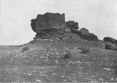
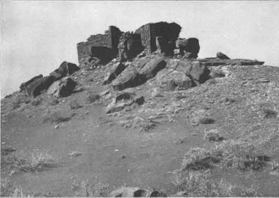
Plate 3. WUKOKI RUIN AT BLACK FALLS (a.
from the south (top); b. from the north (bottom))
|
Victor Mindeleffa summarizes the Hopi
traditions concerning Tokonabi still preserved by the Horn and Flute
clans of Walpi:
The Horn people, to which the Lenbaki [Flute]
belonged, have a legend of coming from a mountain range in the east.
Its peaks were always snow covered, and the trees
were always green. From the hillside the plains were seen, over which
roamed the deer, the antelope, and the bison, feeding on never-failing
grasses. [Possibly the Horn people were so called from an ancient home
where horned animals abounded.] Twining through these plains were
streams of bright water, beautiful to look upon. A place where none but
those who were of our people ever gained access.
This description suggests some region of the
headwaters of the Rio Grande. Like the Snake people, they tell of a
protracted migration, not of continuous travel, for they remained for
many seasons in one place, where they would plant and build permanent
houses. One of these halting places is described as a canyon with high,
steep walls, in which was a flowing stream; this, it is said, was the
Tsegi (the Navajo name for Canyon de Chelly).b Here they built a
large house in a cavernous recess, high up in the canyon wall. They tell
of devoting two years to ladder making and cutting and pecking shallow
holes up the steep rocky side by which to mount to the cavern, and three
years more were employed in building the house. . . .
The legend goes on to tell that after they had lived
there for a long time a stranger happened to stray in their vicinity,
who proved to be a Hopituh [Hopi], and said that he lived in the south.
After some stay he left and was accompanied by a party of the "Horn"
[clan], who were to visit the land occupied by their kindred Hopituh and
return with an account of them; but they never came back. After waiting
a long time another band was sent, who returned and said that the first
emissaries had found wives and had built houses on the brink of a
beautiful canyon, not far from the other Hopituh dwellings. After this
many of the Horns grew dissatisfied with their cavern home, dissensions
arose, they left their home and finally they reached Tusayan.
The early legends of the Snake clans tell how bags
containing their ancestors were dropped from a rainbow in the
neighborhood of Navaho mountain. They recount how they built a
pentagonal home and how one of their young men married a Snake girl who
gave birth to reptiles, which bit the children and compelled the people
to migrate. They left their canyon homes and went southward, building
houses at the stopping-places all the way from Navaho mountain to Walpi.
Some of these houses, probably referring to their kivas and
kihus, legends declare, were roundc and others square.
aSee A Study of Pueblo Architecture, Tusayan and Cibola, in
Eighth Annual Report of the Bureau of Ethnology. The legend was
obtained by Mr. A. M. Stephen.
bEvidently a mistake in identification of localities.
Although the Navaho name Tsegi has persisted as the designation of
Canyon de Chelly, Arizona, there is little doubt that when the Hopi gave
to Stephen the tradition of their former life in "Tsegi," they did not
refer, as he interpreted the narration, to what is now called Canyon de
Chelly, but to Laguna canyon, likewise bordered by high cliffs, which
the Navaho also designate Tsegi. The designation Canyon de Chelly was
used by Simpson in 1810 (Sen. Ex. Doc, no. 64, 31st Cong., 1st sess.),
who wrote (p. 69, footnote): "The orthography of this word I got from
Senor Donaciano Vigil, secretary of the province, who informs me that it
is of Indian origin. Its pronunciation is chay-e."—J. W. F.
cThe circular type disappeared before they arrived in the
valley below Walpi. Legends declare that the original Snake kivas were
circular, and there are references, in legends of clans other than those
that formerly lived in the north, to circular kivas formerly used by the
Hopi.
Some of the ruins here mentioned have been known to
white men for many years. There is evidence that they have been
repeatedly visited by soldiers, prospectors, and relic hunters. The
earliest white visitor of whom there is any record was Lieutenant Bell,
of the 2d (?) Infantry, U. S. A.,a whose name, with the date
1859, is still to be seen cut on a stone in a wall of ruin A.
aProbably Lieut. William Hemphill Bell, of the Third
Infantry, United States Army.
A few years ago information was obtained from Navaho
by Richard and John Wetherill of the existence of some of the large
cliff-houses on Laguna creek and its branches; the latter has guided
several parties to them. Among other visitors in 1909 may be mentioned
Dr. Edgar L. Hewett, director of the School of American Archaeology of
the Archaeological Institute of America. A partyb from the
University of Utah, under direction of Prof. Byron Cummings, has dug
extensively in the ruins and obtained a considerable collection.
b Since the writer's return to Washington this party has
spent several months at Betatakin.
The sites of several ruins in the Navaho National
Monument,c which was created on his recommendation, have been
indicated by Mr. William B. Douglass, United States Examiner of Surveys,
General Land Office, on a map accompanying the President's proclamation
and also on a recent map issued by the General Land Office. Although his
report has not yet been published, he has collected considerable data,
including photographs of Betatakin, Kitsiel (Keetseel), and the ruin
called Inscription House, situated in the Nitsi (Neetsee) canyon. While
Mr. Douglass does not claim to be the discoverer of these ruins, credit
is due him for directing the attention of the Interior Department to the
antiquities of this region and the desirability of preserving them.
cMr. Douglass has furnished the writer the following data
from his report regarding the positions of the most important ruins in
the Navaho National Monument:
| LATITUDE | LONGITUDE |
| Kitsiel, 36° 45' 33" north. | 110° 31' 40" west. |
| Betatakin, 36° 40' 57" north. | 110° 34' 01" west. |
| Inscription House, 36° 40' 14" north. | 110° 51' 32" west. |
The two ruinsd in Nitsi (Neetsee),e
West canyon, are not yet included in the Navaho Monument, but according
to Mr. Douglass these are large ones, being 300 and 350 feet long,
respectively,f and promise a rich field for investigation. That
these ruins will yield large collections is indicated by the fact that
the several specimens of minor antiquities in a collection presented to
the Smithsonian Institution by Mr. Janus, the best of which are here
figured (pls. 15-18), came from this neighborhood, possibly from one of
these ruins.
dOne of these is designated Inscription House on Mr.
Douglass's map (p1. 22).
eAccording to one Navaho the meaning of this word is
"antelope drive," referring to the resemblance of the canyon to such a
structure.
fFor photographs of Kitsiel (p1. 1) and of Inscription House
(here p1. 2). published by courtesy in advance of Mr. Douglass's report,
the writer is indebted to the General Land Office. Acknowledgment is
made to the same office for ground plans of Kitsiel and Betatakin, which
were taken from Mr. Douglass's report.
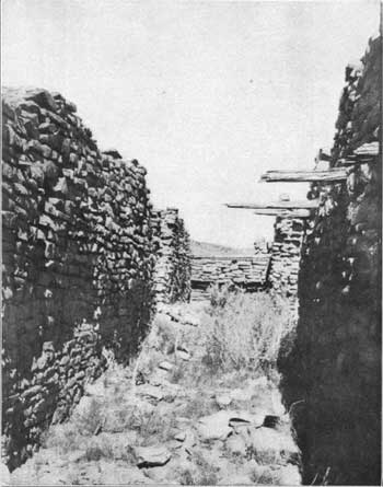
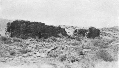
Plate 4. RUIN A, SOUTHWEST OF MARCH PASS
(a. interior (top), b. exterior (bottom))
|
The ruins in West canyon (p1. 2) are particularly
interesting from the fact that the walls of some of the rooms are built
of elongated cylinders of clay shaped like a Vienna loaf of bread. These
"bricks" consist of a bundle of twigs enveloped in red clay, which forms
a superficial covering, the "brick" being flattened on two faces. These
unusual adobes were laid like bricks, and so tenaciously were they held
together by clay mortar that in one instance the corner of a room, on
account of undermining, had fallen as a single mass. The use of
straw-strengthened adobe blocks is unknown in the construction of other
cliff-houses, although the author's investigations at Cliff Palace in
Mesa Verde National Park revealed the use of cubical clay blocks not
having the central core of twigs or sticks, and true adobes are found in
the Chelly canyon and at Awatobi. The ruins in West canyon can be
visited from either Bekishibito or Shanto, the approach from both of
these places being not difficult. There is good drinking water in West
canyon, where may be found also small areas of pasturage owned by a few
Navaho who inhabit this region. The trail by which one descends from the
rim of West canyon to the valley is steep and difficult.
One of the most interesting discoveries in West
canyon is the grove of peach trees in the valley a short distance from
the canyon wall. The existence of these trees indicates Spanish
influence. Peach trees were introduced into the Hopi country and the
Canyon de Chelly in historic times either by Spanish priests or by
refugees from the Rio Grande pueblos. They were observed in the Chelly
canyon by Simpson in 1850.
The geographical position of these ruins in relation
to Navaho mountaina leads the writer to believe that they might
have been built by the Snake clans in their migration south and west
from Tokonabi to Wukoki, but he has not yet been able to identify them
by Hopi traditions.
aHopi legends ascribe the former home of the Snake clan to
the vicinity of this mountain.
But little has appeared in print on the ruins near
Marsh pass. In former times an old government road, now seldom used, ran
through Marsh pass, and those who traveled over it had a good view of
some of these ruins. Situated far from civilization, this region has
attracted but slight attention, although it is one of the most
important, archeologically speaking, in our Southwest. Much of this part
of Arizona is covered with ruins, some of which, as "Tecolote,"b
are indicated on the United States Engineers' map of 1877. In his
excellent articlec on this region Dr. T. Mitchell Prudden gives
us no description of the interesting cliff-dwellings in or near Marsh
pass, though he writes of the ruins in the neighboring canyon: "There
are numerous small valley sites, several cliff houses, and a few
pictographs in the canyon of the Towanache,d which enters Marsh
pass from the northwest." As indicated on his map, Doctor Prudden's
route did not pass the large ruins west and south of this canyon or
those on the road to Red Lake and Tuba.
bThe Mexican Spanish name for the ground-owl, from Nahuatl
tecolotl.
cIn American Anthroplogist, N. S., V, no. 2,
1903.
dThe word bokho ("canyon") is applied by the Navaho to this
canyon; tsegi ("high rocks") is used to designate the cliffs that hem it
in.
Manifestly, the purpose of a national monument is the
preservation of important objects contained therein, and a primary
object of archeological work should be to attract to it as many visitors
and students as possible. As the country in which the Navaho National
Monument is situated is one of the least known parts of Arizona first
place will be given to a brief account of one of the routes by which the
important ruins included in the reserve may be reached.