Three routes to the Monument have been used by
visitors, namely:
(1) that from Bluff, Utah, by way of Oljato or
Moonwater canyon; (2) that from Gallup, New Mexico, via the Chin Lee
valley, and (3) that from Flagstaff, via Tuba and the Moenkopi wash. The
disadvantages of the first route, that used by most visitors, are the
isolation of Bluff from railroads, the treacherous character of the San
Juan river, which must be crossed, and the rugged country near Marsh
pass. From the Gallup road it would be possible to go through the Canyon
de Chelly in full view of many of its greatest cliff-dwellings, and
while facilities for outfitting and purchasing supplies along the route
are not of the best, this route has its advantages.
The writer outfitted at Flagstaff, Arizona, and,
following the "Tuba road," forded the Little Colorado at Tanners
crossing, and continued on to Tuba, a Navaho Indian agency situated near
the Moenkopi wash, where there is a trading place at which provisions
can be had. The road from Flagstaff to Tuba is well traveled, its sole
draw back being the ford of the river, the bottom of which at times is
treacherous. Immediately after leaving Flagstaff this route passes
through a pine forest, which offers many attractive camping places and
where water can always be obtained. For the greater part of the distance
Sunset and O'Leary peaks are in full view and the beautiful San
Francisco mountains are likewise conspicuous. After crossing Deadmans
flat the road descends to Indian Tanks, situated near the lower limit of
the cedar trees; here is a fairly good camping place where water is
generally available. From this camp to Halfway Housea one crosses
a semiarid desert, where wood and water are hard to find.
aA two-room stone house erected by the Indian Bureau for use
of employees.
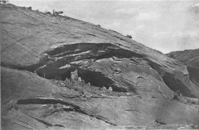
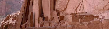
Plate 5. RUIN B AT MARSH PASS
|
One of the most interesting landmarks visible from
the road, after leaving Indian Tanks, is called Superstition mountain,
an elevation situated to the north. According to Navaho stories, phantom
fires are sometimes seen on this mountain on dark nights, recalling an
incident, mentioned in the Snake legend, which occurred when the Snake
clans came south in their early migration from Tokonabi. This legend
states that all this land once belonged to their Fire God, Masauu, who
was likewise god of the surface of the earth. Lights moving around the
mesas are said to have been seen by these ancient inhabitants much as
they are now ascribed to Superstition mountain.
The traveler over the recent lava beds and cinder
plains in the neighborhood of the San Francisco mountains can readily
accept the statement that the early Hopi saw flames issuing from the
earth or the glow of hot lava, which gave substance to the legend still
preserved among this people. It was so natural for them to regard such a
country as the property of their Fire God that their legends state they
inherited the land from him.
The legends of the Snake clans recount also that when
their ancestors migrated from Tokonabi they went south and west until
they reached the Little Colorado river, where they built many houses of
stone. They remained there several years, but later left these houses
and continued in an easterly direction to Walpi. Where are the ruins of
these ancient houses of the Snake clans on the Little Colorado? There
are several Little Colorado ruins, as Homolobi near Winslow, but Hopi
traditions affirm these were built by people who came from the south.
Lower down the river at the Great Falls are other ruins, but these
likewise are ascribed to southern clans. The cluster of stone buildings
near the Black Falls conforms in position and direction from Walpi to
Hopi legends of the site of Wuk´ki, the Great Houses built by Snake
clans before they went to Walpi. In their migration from Tokonabi,
probably the Snake people tarried here and built houses, and then went
on to the Bear settlements or the Hopi pueblos, where their descendants
now live. More extensive archeologic work on these ruins may shed
additional light on this identification, and it is interesting to
compare in point of architecture the buildings at Black Fallsa
with those of extreme northern Arizona.
aFor plates representing ruins at Black Falls, see
Twenty-second Annual Report of the Bureau of American Ethnology.
Plate 3 (hitherto unpublished) of the present report represents one of
the characteristic Black Falls ruins, which closely resembles several of
the characteristic ruins standing on low hills near the road to Marsh
pass, beyond Red Lake.
The architecture of the ruins on the Little Colorado
near Black Falls resembles that of the open ruins, especially Ruin A,
and those near the road from Bekishibito to Marsh pass. While great
weight can not be given to this resemblance, since we find much
uniformity in stone ruins everywhere in the Southwest, it is interesting
to take in connection with this fact the close likeness in minor objects
from the Laguna Creek ruins and the Black Falls cluster. The prevailing
ware from both is the gray pottery with black geometrical ornamentation
and red ware with black or brown decoration. The red ware and the yellow
ware, so abundant higher up the river, are not the prevailing kinds. The
pottery of the Black Falls ruins is essentially the same type as that of
the San Juan and its tributaries.
An obscure trail branches from the Tuba road to the
Black Falls ruins just beyond the cedars below Indian Tanks, and the
black walls of the so-called "citadel" of this cluster are conspicuous
for a considerable distance before one leaves the main road. The ruin
here figured is some distance beyond the "citadel" and is hidden from
view by intervening hills and mesas, but from the time the traveler
crosses the valley of the Little Colorado and goes down into the
Moenkopi wash he follows approximately the old trail the Snake people
took in their southerly migration from Tokonabi.
Near Tanners crossing on the left bank, a short
distance down the river, Mr. Janusa has cemented a small basin
above the highest level of the flood, into which always flows pure
water. The road from the river to Moenkopi wash passes through a region
where there is very little wood for camping and no water. The distance
from Flagstaff to Tuba, about 90 miles, may be traveled in two days by
taking the midday meal of the first day at Indian Tanks and camping the
first night at Halfway House, where there is water for horses.
aMr. Stephen Janus, agent of the Northwestern Navaho, to
whom the author is indebted for many kindnesess, joined him at Tuba and
made the trip to Marsh pass and the neighboring ruins with his
party.
The pueblo settlement of Moenkopi ("place of the
running water"), which lies not far from Tuba, will give the visitor a
fair idea of a small Hopi pueblo. This settlement is said to be
comparatively modern and to have been made by colonists from Oraibi, but
there are reasons to believe that it dates back to the middle of the
eighteenth century. The pueblo is inhabited mainly by Pakab (Reed)
clans, a people of late advent in the Hopi country, whose arrival
therein was subsequent, at all events, to that of the Snake clans. The
houses of Moenkopi are arranged in rows, and it has one ceremonial room,
or kiva, not unlike the kivas of Walpi. None of the great nine-days
ceremonies of the Hopi is performed at Moenkopi; such dances as exist,
called katcinas, are conducted by masked participants. Possibly
the presence of Pakab clans in this pueblo is accounted for by need of
warriors in its exposed position, for the chief of the Hopi Warrior
society (at Walpi) belongs to the Pakab clan. The ruins about Moenkopi
are small and inconspicuous, but those between this pueblo and Oraibi
are of considerable size.
Beyond Tuba the road is rough, running over upturned
strata of rocks and extending along sandy stretches of plain and hills
to Red Lake, where there is an Indian trading store owned by well-known
merchants of Flagstaff.b Here also provisions may be obtained for
the trip and abundant water for stock. The road now becomes more
difficult. Just after leaving Red Lake there may be noticed to the left
two great pinnacles of rock called Elephant Legs, not unlike those in
Monument canyon, Utah, and far to the north the cliffs are fantastically
eroded. The White Mesa natural bridge, visible from Red Lake, is one of
the scenic features of this locality. There are prehistoric burials in
the sands near Red Lake, from which have been obtained several beautiful
specimens of pottery resembling in the main those from the Navaho
National Monument and from the Black Falls ruins.
bThe presence of excellent traders' stores at Tuba and Red
Lake renders it unnecessary to carry groceries or fodder from
Flagstaff.
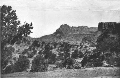
Plate 6. VIEW INTO LAGUNA CANYON FROM MARSH PASS
|
The road continues from Red Lake to Bekishibito (Cow
Spring),a where the water issues from under a low cliff,
spreading in the wet season over the adjacent plain and forming a
shallow lake several miles long, whose bottom is somewhat dangerous on
account of quicksands. When there is water a rich mantle of grass—a
boon to travelers in this dusty land—covers the plain, making an
attractive camping place. This stretch of the road, not more than 20
miles in length, is fairly good and easily traversed by wagons.
aSpanish; vaca, "cow"; Navaho, shi, "her";
to, "water".
After leaving Bekishibito, the road to Marsh pass,
although on the whole not bad, becomes more and more obscure. The
traveler now enters the region of ruins, and passes several mounds
indicating former habitations, some of which still have standing walls.
Several pools of water, reduced to little more than mudholes, are found
along the road, but a constant supply of potable water is found at the
sand hills in the Black mesa opposite the butte called by the Navaho
Saunee, 30 to 40 miles distant from Cow Spring. The distance from Red
Lake to this camp is a good day's journey with a heavily loaded
buckboard, noon camp being made at Bekishibito. From Saunee one can
easily reach Marsh pass in another day, making in all five "sleeps" from
Flagstaff to Marsh pass. The only serious difficulties on the route are
encountered as one ascends the pass, but a few weeks' work here would
make the whole road from Tuba to Marsh pass as good as that from
Flagstaff to Tuba, which is considered one of the best in this part of
Arizona.
A large ruin with high walls is visible on a
promontory of the Sethlagini plateau westward from this camp. This ruin,
as well as another near the road, about halfway from the sand hills to
Bekishibito, was not studied; the latter, which lies only a short
distance from the road, on a low rocky hill, was visited and found to be
the remains of a small pueblo, more or less dilapidated but with
standing walls. The fragments of pottery in this vicinity are not unlike
those found at the Black Falls ruins, and the masonry of the ruin is
almost identical in character. At the time of the writer's visit there
was a pool of water, not very inviting even to horses, a few hundred
feet from this ancient habitation. Numerous sheep pasturing in the
neighborhood befoul this pool, so that it can not be depended on to
supply the needs of either men or horses. The road (plate 2) follows the
valley west of the great Sethlagini mesa, over a hill and finally down
again to a Navaho cornfield, the owner of which served as a guide to the
large ruin A.