|
ICE AGE
Geology of Ice Age National Scientific Reserve of Wisconsin NPS Scientific Monograph No. 2 |

|
CHAPTER 8:
Mill Bluff Pinnacles
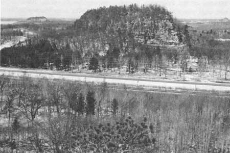
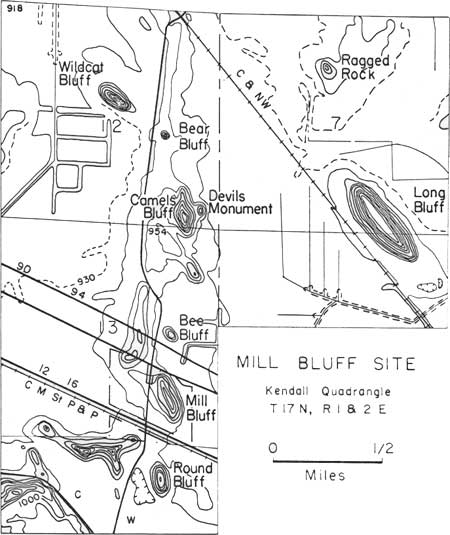
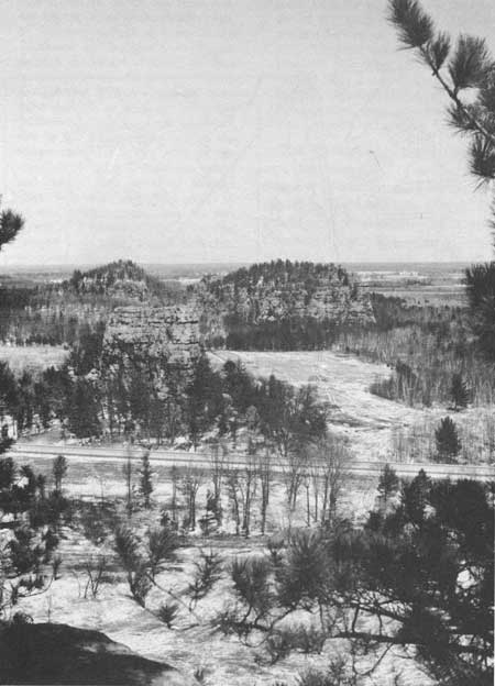
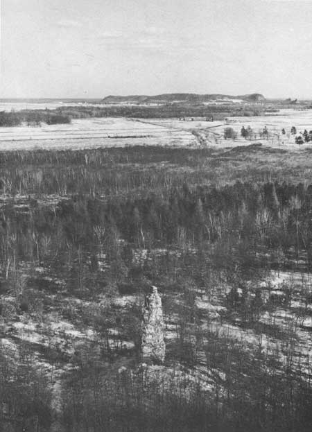
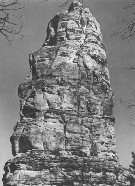
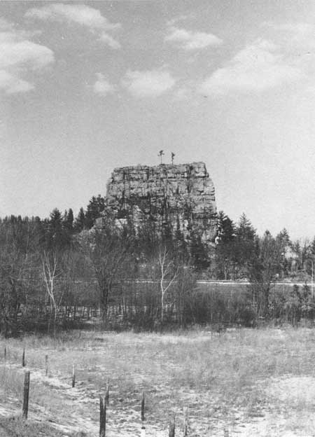
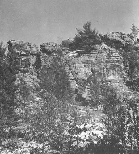
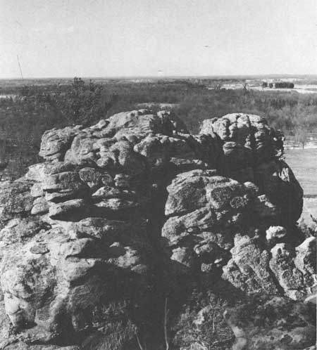
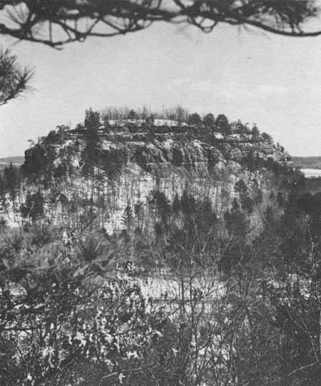
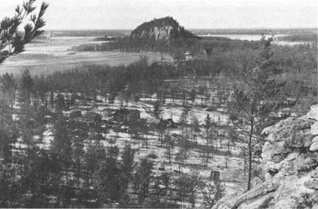
Mill Bluff (Fig. 84), currently a state park, is the locus of a number of "Bluffs" with appropriate names (Figs. 1, 2, 3, 46, 85). Each, whether called Bluff, Monument, or Rock (Fig. 85), generally has had a similar origin and is composed of the same Upper Cambrian sandstone (the Ironton Member of the Franconia Formation caps many and the Galesville Member of the Dresbach Group forms the base). They are striking features because they rise so abruptly from such a flat surface (Fig. 86), and because their yellowish sandstone contrasts with the green vegetation that surrounds and partly covers them. Some are pinnacles in the sense of being a tall, slender, pointed mass (Figs. 87, 88). More resemble the buttes of western United States (Figs. 89-91). Others are rounded (Figs. 92, 93) or irregular, like Ragged Rock and the unnamed ridge west of Round Bluff (Fig. 85). Genetically the geologist would call them "stacks" for their precipitous sides have been carved by wave and current action in Glacial Lake Wisconsin, where they stood as isolated islands during one or more ice advances of Woodfordian age into central Wisconsin. They are "outliers" of the Franconia cuesta, the Upper Cambrian sandstone that to the southwest and south comprises a continuous upland surface at and slightly above the level attained by the pinnacles. The sandstone lies unconformably on the Precambrian shield rocks from which weathering and erosion is stripping it away (Fig. 3).
|
| Fig. 84. Mill Bluff, looking northward from Round Bluff. See Fig. 85. |
|
| Fig. 85. Topographic map of the Mill Bluff area. After the U.S. Geological Survey Topographic Quadrangle—Kendall. |
|
| Fig. 86. Bee, Camels, and Wildcat Bluffs looking northward from Mill Bluff. See Fig. 85. |
|
| Fig. 87. View southeastward from Camels Bluff toward Camp Douglas. Spire, about 40 ft high, is here called Devils Needle. |
|
| Fig. 88. Detail of Devils Needle, immediately south of Devils Monument. |
|
| Fig. 89. Bee Bluff, looking northeastward from County Highway W overpass at I-90. See Fig. 85. |
|
| Fig. 90. Camels Bluff, looking eastward toward the northern part. See Fig. 85. |
|
| Fig. 91. Camels Bluff, at the north end, looking north-northeastward at part of the upper Cambrian sandstone and the plain of Glacial Lake Wisconsin. |
|
| Fig. 92. Round Bluff, looking east-southeastward from the ridge to the west. See Fig. 85. |
|
| Fig. 93. Wildcat Bluff, looking northwestward from the north end of Camels Bluff. See Fig. 85. |
The state park is a very restricted area encompassing Mill Bluff only (Fig. 84). In order to insure an uncluttered view and the preservation of a representative sample of the pinnacles the present park should be expanded to include all shown in Fig. 85. Although the sandstone comprising them is generally of little commercial value, it is soft and easily modified by man's use. Protection by inclusion in the Reserve is mandatory for their future best use.
Martin (1932:317) succinctly described some of the pinnacles and states their value:
If a traveler, on his way from eastern United States to the Pacific coast, be fortunate enough to cross central Wisconsin by daylight he will pass through the village of Camp Douglas or the village of Merrillan. At Camp Douglas and Merrillan, and for many miles nearby, he may see landscape features totally unlike those anywhere else in the United States east of the Mississippi River. The hills of the region near Camp Douglas are buttes and mesas. They have the straight lines, steep cliffs, and sharp angles of an arid country rather than the soft curves of a humid region. . . . The features to be seen . . . are (a) isolated, rocky hills which resemble ruined castles, (b) grostesque towers and crags of sandstone along a line of bold, irregular bluffs, and (c) an unusually flat plain, which stretches away beyond the northern and eastern horizons. The bluffs and steep slopes on the west and south form the escarpment at the border of the Western Upland [Southwestern Upland of Black 1964b:171-177]. The level country is the Central Plain of Wisconsin. Not all of the Central Plain is exactly like the Camp Douglas Country. This, however, is a representative part, and one of the most beautiful and striking.
The flat-topped buttes in this area owe their angularity of outline to the selective cementation of certain horizons in the Dresbach Group and Franconia Formation of Upper Cambrian age. The cement commonly is ferric oxide, but silica seems almost equally abundant or important. These "case harden" the rock, making it more resistant to normal weathering and erosion which then must attack joints. By breaking the rock along joints and bedding planes, especially through frost action, the angularity of the buttes is preserved. As. soon as the cemented horizons are removed, however, and particularly in the Galesville Member of the Dresbach Group, the lack of cement shows up by a general rounding of outcrops and the transition of the angular buttes to conical hills.
The selective cementation has not been studied in detail. Presumably it came about by ground water activity and is not restricted to any particular horizon over a broad area. Banding of zones of dark red iron oxide contrasts markedly with white to yellow quartz sandstone locally in what is called "zebra rock." The iron-cemented zones in pipes, layers, bands, and the like, in places only a fraction of an inch in size, stand out on weathered surfaces as resistant nodes. In places the zones emphasize cross stratification, ripple marks, and fossils; in other places the iron oxide zones cut across them. Where the sandstone is free of iron oxides, it can usually be removed easily with one's fingers.
The grotesquely weathered forms are considered by Martin (1932:329) to have originated prior to glaciation and elsewhere to have been removed by the ice except in the Driftless Area. However, Weidman (1907:602) stated flatly that their picturesque forms clearly were acquired after early ice invasions. I recognize that the various pinnacles, monuments, and buttes are not common in areas covered by the late Woodfordian ice, but they are common and well-developed in areas covered by the much earlier Rockian (late Altonian) ice. However, local conditions may be more important than time in the formation of such features. Certainly wave action in Glacial Lake Wisconsin accelerated erosion there, and similar features are seen today being produced along the south shore of Lake Superior.
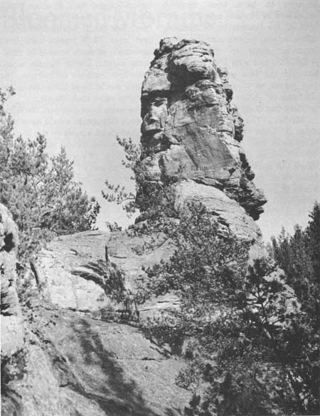
The area of Footville Monument (Frye et al. 1965:43-61) in southern Wisconsin and many other pinnacles (Fig. 94) of sandstone are known to have been covered with ice as late as 30,000 years B.P., and the bizarre forms evolved since. This is not a surprising or unusual rate of erosion when one sees how soft the rock actually is. One castellated spur in southern Wisconsin (Frye et al. 1965:43-61) is reported to have "grown" from a sandstone ridge during the lifetime of the local residents. It too was formerly glaciated. The larger buttes and mesas generally require more time than the smaller pinnacles and monuments.
|
| Fig. 94. Pinnacle, 30 ft high above left shoulder, at the north end of Bruce Mound, 2 miles east of Merrillan, Clark County. The pinnacle is at an elevation of about 1240 ft, well above the level of Glacial Lake Wisconsin but several miles within the boundary of the older drift. It is believed to have formed since glaciation of the mound. |
Locally the sandstone is sufficiently cemented to retain glacial polish and striations such as may be seen on one of the stone steps in the trail to the top of Mill Bluff. (The possibility that the surface was produced by faulting cannot be ruled out entirely.) Its quarry site has not been located, but surely is nearby. To the north the nearest prominent moraine of the older drift lies near the north boundary of Jackson County, and that of the late Woodfordian ice lies to the east in Adams and Waushara counties. However, Akers (1964) reports in detail on glacial drift and other phenomena related to glaciation west and southwest of Tomah. That study, done in part by me and under my supervision, is considered indisputable proof of glaciation of the area 30,000 or more years B.P. Much of that story still remains to be told.
Glacial Lake Wisconsin at one or more times probably was joined with Glacial Lake Baraboo in a huge lake covering most of Juneau County and large parts of the adjoining counties (Figs. 1, 2). It formed in front of the Cary ice, and probably other advances during Woodfordian and earlier times, being trapped by the higher land to south, west, and north. So long as the present valley of the Wisconsin River around the east nose of the Baraboo Range was filled with ice, water in the Central Plains was backed up to the level of the lowest divide across the Southwestern Uplands——about 1000 ft in the vast swamp between the Black River drainage to the Mississippi River and that of the Lemonweir and Yellow rivers, now tributary to the Wisconsin River. The divide is thought to have been centered northwest of Mather, near the junction of the boundaries of Jackson, Monroe, and Juneau counties. Topographic maps on the scale of 1:250,000 and with 100-ft contours are still the best available and do not permit us to alter the original findings of Alden (1918:223) regarding that divide.
Martin (1932:340) believed that Glacial Lake Wisconsin merged with water west of the Black River divide, whose outlet was westward down the East Fork of Black River from Scranton, Wood County, to Hatfield, Jackson County and thence southward down Black River. Near Pray and Hatfield the stream has a broad valley—presumably oversized for the present stream. Martin attributes its granite and greenstone boulders to be erratics from Glacial Lake Wisconsin, but I have found moraine with many igneous erratics south of that stream.
Alden (1918:223) found erratics in the Lake Baraboo basin to an elevation of 980 ft. The moraine at the north end of the West Bluff of Devils Lake is firmly plastered against the rock at an elevation of 1060 ft, leaving little doubt that the level of Black River divide must have been reached. The level of the plain shown in Fig. 85 is about 920-940 ft.
Assuming Glacial Lake Wisconsin attained a level of about 1000 ft, and ignoring any isostatic effects of the weight of water and ice on the land, the Mill Bluff area should have been a lake 60-80 ft deep. The top of Ragged Rock at about 990 ft would have almost reached the surface; Bee Bluff, Devils Monument, and Bear Bluff would have been essentially at water level at its maximum height; Devils Needle would have been entirely submerged. The others would have risen above the water as small rock islands.
As water level dropped, the flanks of each monument would have been washed clean almost to the level of the plain—the former lake bed with a thin layer of postglacial sand and organic matter on it. The upper few feet of debris may be seen in road cuts in the vicinity. Many tens of feet of deposits are known over an area of almost 2000 mile2. The coarser deposits are in the north and east, close to the ice fronts; red silts characterize the southern part. Only brief study of the sediments has been made (Harloff 1942).
Alden (1918:225-226) reports on sediments deposited in Glacial Lake Baraboo that suggest more than one stage of filling separated by an accumulation of marsh muck. Squier (1916) reported crystalline rocks in rounded gravel and a buried log at a depth of 100 ft in the lacustrine deposits 6 miles northeast of Tomah. We know a lake occupied much of the Central Plains, at least once. The tremendous volume of material, breaks in stratigraphy, and our understanding of glacial fluctuations in Wisconsin suggest it existed several times. However, much study is needed to define the extent of the former lake, its sediments, and former history.
| <<< Previous | <<< Contents >>> | Next >>> |
chap8.htm
Last Updated: 1-Apr-2005