 | ||
 | ||
 | ||
 | ||
 | ||
 | ||
 | ||
 | ||
 | ||
 | ||
 | ||
 | ||
 | ||
 | ||
 | ||
 | ||
 | ||
 |
 |
 |
Yosemite Roads and Bridges
Yosemite National Park, California
MODERN ROADS FOR MODERN TIMES
In 1925 the National Park Service signed an agreement with the Bureau of Public Roads, U.S. Department of Agriculture, under which the BPR (later, the Public Roads Administration) would be responsible for upgrading and reconstructing roads within the National Park System. The BPR immediately commenced road work in Yosemite National Park, beginning with the paving of the Valley road system in 1926 to eliminate the choking dust that irritated so many visitors.
The BPR then planned a new "high gear" highway to replace the 1875 Wawona Road between the park's south entrance and Yosemite Valley. Construction began in 1932. The Park Service insisted that the new road should not adversely affect the park's scenic qualities. To preserve the beauty of the Valley landscape, a 4,230' tunnel was bored below Turtleback Dome. The new $2 million Wawona Road was completed in 1933, and in 1934-35 the spur road to Glacier Point was rebuilt. Motorists could now enjoy some of the park's most outstanding views.
Work followed on rerouting the Big Oak Flat Road. again employing tunnels and stone retaining walls for concealment. The new road offered stunning views of the Big Meadow area and the Crane Creek valley. The section between Crane Flat and the Valley floor opened in 1940, and the remaining part from Crane Flat to the north entrance was built in 1969. While Big Oak Flat Road was being rebuilt, work began on the east and west ends of Tioga Road: the central section, blasted through the landscape at Olmsted Point. was completed in 1961.
[Visitors may still drive on a portion of the old Big Oak Flat Road through the Tuolumne Grove of Giant Sequoias; on Tioga Road along the access road to Yosemite Creek Campground and along a short section at the May Lake turnoff.]
Another modern highway project, Hetch Hetchy Road, used a railroad right of way, built by the City of San Francisco in 1916 during the construction of Hetch Hetchy Reservoir. The City converted it into a park motor road in 1925.

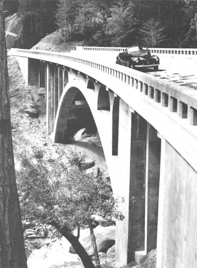
Wildcat Creek Bridge, 1939, marked a transition from the Rustic Style to a streamlined highway design. YRL |
CARING FOR THE LANDSCAPE
The National Park Service and the Bureau of Public Roads showed great care in constructing a modern road network through the incomparable scenery of Yosemite. Preservation of the park's natural beauty was the planners' chief concern, and every modification of the landscape was subjected to careful scrutiny. The roads were designed not only to carry heavy traffic loads, but to integrate into their natural settings.
To minimize the effect of roads through the landscape, tunnels were bored to avoid unsightly scarring of the granite cliffs. Stone retaining walls were employed to conceal road cuts, and bridges faced in natural materials were used at highly visible stream crossings. Telephone and power lines were located away from the roadside and out of the visitors' view. Road margins were reseeded with native plants by the park's landscape division, and in some cases by the Civilian Conservation Corps. The special Rustic Style designs and landscaping help the roads blend into their natural surroundings and make a drive through the park a wondrous experience.
| Introduction | Acadia | Blue Ridge Parkway | Chickamauga and Chattanooga | Colonial Parkway | Generals Highway | George Washington Memorial Parkway | Great Smoky Mountains | Mount Rainier | Rock Creek and Potomac Parkway | Shenandoah's Skyline Drive | Southwest Circle Tour | Vicksburg | Yellowstone | Yosemite |
