|
Abraham Lincoln Birthplace
Historic Resource Study |

|
Introduction:
DESCRIPTION OF THE ABRAHAM LINCOLN BIRTHPLACE NATIONAL HISTORIC SITE
CONTEMPORARY DESCRIPTION
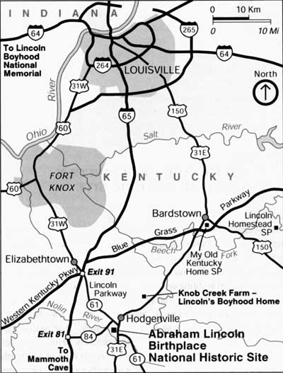
Abraham Lincoln Birthplace National Historic Site (Site) commemorates the birthplace of Abraham Lincoln, sixteenth president of the United States. The Site contains 116.5 acres, representing approximately one-third of a 348.5-acre farm along the South Fork of Nolin Creek that was purchased by Lincoln's father, Thomas Lincoln, in 1808. [1] On the Site is a Beaux-Arts classical granite and marble memorial building containing the traditional Lincoln birth cabin. A notable natural feature on the Site is a spring that emerges from a rock ledge and flows into a deep sinkhole. The spring is adjacent to the knoll on which the Memorial Building is located. Roughly triangular in shape, the Site is located in the rolling hill country of LaRue County, Kentucky, three miles south of Hodgenville, the county seat, and approximately 50 miles south of Louisville (see Figure 1). [2] U.S. Highway 31E/Kentucky Highway 61 bisects the Site on a north-south axis.
|
| Figure 1: Abraham Lincoln Birthplace National Historic Site vicinity map, 1999 |
The Site lies in the extreme eastern portion of the Pennyroyal, an approximately 8,000-square-mile physiographic region in west-central Kentucky. The Pennyroyal is part of the Highland Rim section of the Interior Low Plateau physiographic province. The Pennyroyal is a karst region, the topography of which is produced by the dissolution of soluble limestone by water and characterized by underground streams and caves, sinkholes (dolines), small ponds, long valleys, rolling hills, and occasional steep ridges and stone escarpments. Approximately seven miles east of the Site, Muldraugh's Hill, a large limestone escarpment, marks the eastern boundary both of the Pennyroyal and the karst region. Soil fertility varies considerably with the terrain. The most fertile LaRue County areas are the watershed of the Nolin River and the bottomlands of the Rolling Fork River, which forms the county's eastern boundary. LaRue County retains a predominantly rural character; farms of fewer than two hundred acres raising crops of wheat, tobacco, soybeans, and corn are typical. The northeastern and southeastern portions of the county are heavily forested. [3]
HISTORIC DESCRIPTION AND DEVELOPMENTAL CHRONOLOGY OF THE ABRAHAM
LINCOLN BIRTHPLACE. NATIONAL HISTORIC SITE
The farm Thomas Lincoln and his wife Nancy moved to in 1808 was just within the borders of "the Barrens," a four-hundred-square-mile subregion of the Pennyroyal that Native Americans had burned repeatedly to create grazing land for game. Tall grasses dominated the Barrens, with scattered trees present only along stream courses. Locally known as the Sinking Spring Farm, the Lincoln property contained a large spring that flowed through a limestone channel, dropped into a sinkhole, and disappeared into the earth. On high ground close to the spring, the elder Lincoln constructed a log cabin, where his son Abraham was born on February 12, 1809. []4 The young Lincoln lived on the Sinking Spring Farm for only two years; in 1811, after a legal dispute centering on land patents, the Lincolns moved to a 230-acre farm on Knob Creek, approximately ten miles northeast. [5]
The idea for a memorial at Lincoln's birthplace was established by the Lincoln Farm Association (LFA), a nonprofit organization formed by Robert Collier, publisher of Collier's Weekly. In 1905, the LFA purchased a 110-acre portion of the original Lincoln Sinking Spring Farm intending to create a national memorial to Lincoln. The LFA also purchased a set of logs identified by some local residents as coming from the original Lincoln birth cabin. The birth cabin had been dismantled sometime prior to 1865, and a local tradition held that some of the logs were removed and used to construct a nearby house. By 1905, the logs associated with the Lincoln birth cabin were in storage in New York. [6]
|
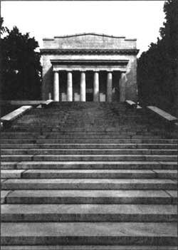
| Figure 2: Memorial Building and Steps, 1987 |
The LFA commissioned architect John Russell Pope to design a memorial building on the knoll near the spring, identified by some as the site of the birth cabin. The Memorial Building, completed in 1911, was carefully sited within a formal, designed landscape that featured a terraced approach leading from a court. Upon the building's completion, the LFA removed the logs from storage, moved them into the Memorial Building, and erected them into a cabin which in their view approximated the appearance of the original Lincoln birth cabin. In 1916, the LFA donated the cabin, Memorial Building, and surrounding 110 acres to the Federal government, which established the Abraham Lincoln National Park. The War Department administered the park until August 10, 1933, when it was transferred to the National Park Service (NPS). The park was designated a national historical park August 11, 1939, and was renamed the Abraham Lincoln Birthplace National Historic Site on September 8, 1959. The NPS expanded the park's boundaries with the purchase of approximately 5.25 acres, authorized May 27, 1949, and another addition, authorized April 11, 1972. [7] In 1998, Congress authorized the Secretary of the Interior to acquire the approximately 228 acres of land and the cultural and natural resources of the historic Knob Creek Farm.
Development of the Site after 1916 focused on areas other than the Memorial Building and terraces. In the late 1920s, the War Department constructed limestone steps and walls at the Sinking Spring, built a parking area, and created a formal, rectangular plaza in place of the unpaved court. The current appearance of the memorial landscape thus partially reflects the original 1911 design, as well as later War Department alterations intended to improve visitor access and give the court a more finished appearance. Some historic materials have been replaced—notably, the tree species flanking the terraces and the flagstone pavers of the plaza, but the formal, ceremonial aspects of the approach to the Memorial Building are unchanged. Beyond the immediate area of the Memorial Building, secondary growth forest covers about half the Site, with the rest consisting of expansive mowed lawns. The Site also includes a 1959 Mission 66 visitor center and two employee residences, two small stone maintenance buildings constructed by the War Department, and a maintenance garage. The visitor center contains interpretive exhibits on the Lincoln family, including Thomas and Nancy Lincoln's Bible. Southwest of the Memorial Building is the former site of the Boundary Oak, a large white oak frequently cited in land surveys. In 1949, NPS acquired six acres surrounding the Boundary Oak, which died in 1976. [8] East of U.S. 31E lie park recreational facilities, including a picnic area with a restroom building and pavilion, several forest trails, and an environmental study area. Some commercial development, including motels and a convenience store, has occurred north of the park, and the potential exists for further development both north and south of the park boundary.
SCOPE AND PURPOSE OF HISTORIC RESOURCE STUDY
The Historic Resource Study (HRS) identifies and evaluates, using National Register criteria, the historic resources within the park. The study establishes and documents historic contexts associated with the park and evaluates the extent to which the historic resources represent those contexts. The completed HRS will serve as a tool for future Site planning, resource management, and the continuing development of interpretive programs at the park.
The Abraham Lincoln Birthplace National Historic Site was entered on the National Register of Historic Places October 15, 1966. National Register documentation for the Site was accepted December 17, 1977. Currently, the National Register boundary encompasses the entire Site. National Register additional documentation that will be prepared from this HRS will retain the Site boundary as the National Register district boundary. The Memorial Building, terraces, court, stone walls and paths, and Sinking Spring, developed by the LFA and the War Department between 1909 and 1933, constitute the core of the memorial landscape, but the Site itself was all part of the historic Thomas Lincoln farm. The goal of the LFA was to set aside the entire Site as a memorial to Lincoln, although only a portion of it was given a more formal treatment. In the 1950s, NPS removed a number of buildings—the Creal House, a picnic pavilion, and a comfort station—from the Site and reconfigured parking areas to accommodate a new visitor center.
SUMMARY OF IDENTIFICATION AND EVALUATION METHODS
Survey Methodology
Goals of the historic resource survey of the park are to 1) update the List of Classified Structures (LCS) database for the park for use by park management; 2) prepare a Historic Resource Study for the park; 3) update the park's National Register documentation; and 4) assemble a comprehensive structural survey consisting of completed Kentucky State Heritage Council survey forms, when applicable, and a photographic record for each structure built prior to 1950 and considered eligible for listing in the National Register. This will be used in complying with Sections 106 and 110 of the National Historic Preservation Act of 1966.
Initially, the survey team examined building files, maintenance records, historic research compiled by the park staff, and maps located at the park headquarters. The field survey of the park yielded information on the present condition of the historic resources. Additionally, the team reviewed archival materials at the Southeast Regional Office of the National Park Service. Research with primary and secondary sources was conducted at the park library and research libraries to obtain information relating to Lincoln's life and legacy and the creation and development of the Site.
DETERMINATION OF HISTORIC CONTEXTS
This study assesses eligibility and evaluates historic integrity of the Site's historic resources within two historic contexts identified and refined by the survey team. These contexts relate to historic themes identified by the National Park Service and the Kentucky Heritage Council. The thematic framework of the NPS is outlined in Revision of the National Park Service's Thematic Framework 1996. Kentucky historic contexts are developed within an overall framework that employs three elements: geographic area, time period, and theme. The NPS thematic framework uses similar historical building blocks: people, time, and place, in addition to eight overlapping themes and associated topics, several of which are relevant to this HRS. The following four chapters form this study:
Chapter One: The Importance of Abraham Lincoln and his Birthplace
Chapter Two: Lincoln Commemoration and the Creation and Development of the Abraham Lincoln Birthplace National Historic Site, 1865-1935
Chapter Three: The American Public Memorial and the Design and Construction of the Lincoln Birthplace Memorial, 1906-1911
Chapter Four: Management Recommendations
Because Abraham Lincoln is one of America's most famous historic figures, Chapter One serves as an overview of his life, his national significance, and how each relates to his Kentucky birthplace; it is not a historic context in itself Chapter Two and Chapter Three represent the two historic contexts noted above. Chapter Two relates to NPS theme II "Creating Social Institutions and Movements," specifically, that theme's topic of "clubs and organizations." The topic of "recreational activities" is also addressed in the chapter. Chapter Three relates to NPS theme III "Expressing Cultural Values," and addresses the topics of "architecture, landscape architecture, and urban design," "educational and intellectual currents," and "popular and traditional culture." Chapter Two begins in 1865, the year of Lincoln's death, when commemorative activity began, and ends in 1935, which marked the completion of major development activity at the Site during the historic period. Chapter Three begins in 1906, the year the Lincoln Farm Association was formed, and ends in 1911, the year of dedication of the Memorial Building. Within the Kentucky historic context framework, the two contexts developed for the HRS relate to the geographic area of the Pennyroyal. Chapter Two relates to the time periods 1865-1918 (Kentucky in the Age of Industrialization) and 1918-1945 (Between the Wars), while Chapter Three relates to the 1865-1918 period only. Kentucky has not identified commemoration as a general theme; aspects of Chapter Two relate to the broad Kentucky themes of commerce and transportation. Chapter Three relates to the Kentucky themes of architecture and landscape.
Four historic contexts developed for a National Register nomination for the LaRue County Multiple Resource Area also proved useful in developing contexts for the HRS. These contexts are The Growth and Development of LaRue County, ca. 1780-1865; The Growth and Development of LaRue County, 1865-1940; The Growth and Development of Hodgenville, 1865-1940; and Lincoln Iconography, 1909-1940. [9]
HISTORICAL BASE MAP DISCUSSION
The Historical Base Map depicts the existing contributing and noncontributing resources of the park, as well as roads, trails, parking areas, and visitor facilities. The boundary of the park corresponds with that of the National Register District. The original National Register nomination addressed only the Traditional Birthplace Cabin and the Memorial Building. Future updates of National Register documentation should address the other park features noted in the HRS, especially the Memorial Building landscape. The park's Mission 66-era structures should also be addressed in any future cultural resource documentation.
NOTES
1. Benjamin P. Thomas, Abraham Lincoln: A Biography (New York: Modern Library, 1968), 7; Louis A. Warren, Lincoln's Parenthood and Childhood (New York: Century Co., 1926), 75; The National Parks: index 1991 (Washington, D.C.: National Park Service, Office of Public Affairs and Division of Publications, 1991), 41. As is noted in Chapter One of this study, Thomas Lincoln never held clear title to the Sinking Spring Farm.
2. LaRue County was created in 1843 from a portion of Hardin County (Philip Thomason, "LaRue County Multiple Resource Area," Draft National Register of Historic Places Documentation Form, November 19, 1990, E3).
3. Federal Writers' Project, Kentucky: A Guide to the Bluegrass State, American Guide Series, sponsored by the University of Kentucky and the Works Project Administration (New York: Harcourt, Brace and Co., 1939), 10-11; Thomason, E1-E3; Albert J. Beveridge, Abraham Lincoln: 1809-1858, vol. I (Boston: Houghton Mifflin, 1928), 26-27.
4. Thomas, 7; Warren, 87; Beveridge, vol. I, 3-4, 23-25.
5. Mark E. Neely, Jr., The Abraham Lincoln Encyclopedia (New York: McGraw-Hill, 1982), 188; Warren, 11-12. Thomas Lincoln leased a portion of the Knob Creek farm only in 1815, but county commissioners' tax books indicate that he occupied the farm as a renter beginning in 1811 (Warren, 109-11).
6. Gloria Peterson, An Administrative History of Abraham Lincoln Birthplace National Historic Site (Washington, D.C.: National Park Service, Division of History, 1968), 19-23; Roy Hays, "Is the Abraham Lincoln Birthplace Cabin Authentic?" The Abraham Lincoln Quarterly 5 (September 1948): 152-53.
7. Peterson, 30, 33-4; The National Parks: Index 1991, 41.
8. "Statement for Management, Abraham Lincoln Birthplace National Park" (National Park Service, Hodgenville, Kentucky, April 25, 1989, Typescript), 10-11.
| <<< Previous | <<< Contents >>> | Next >>> |
abli/hrs/introduction.htm
Last Updated: 22-Jan-2003