|
Buffalo National River Arkansas |
|
 NPS photo | |
A River Nestled in the Arkansas Ozarks
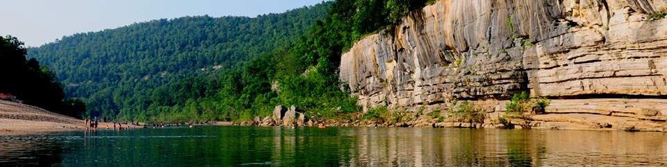
How did this river escape impoundment, impairment, and massive change? To preserve the Buffalo River as a free-flowing stream, Congress designated it as America's first national river in 1972. It nestles in the Arkansas Ozark Plateau, which is bounded on the north, east, and south by the Missouri, Mississippi, and Arkansas rivers. Earliest maps called this the "Buffaloe Fork of the White River," no doubt for now-extinct woodland bison. Originating high in the Boston Mountains, the Buffalo drops steadily to its confluence with the White 151 miles to the east. The gradient is steeper and the water faster on the upper river, but the river levels out and slows down over its course. Long, quiet pools between rapids disguise its vertical fall.
Side trips to hollows flanking the river dramatize this land's wildness and isolation. Some of the many prehistoric and historic cultural sites are 8,000 years old. There are village sites on river terraces, seasonal bluff shelters of prehistoric hunters and gatherers, and farmsteads of the Mississippian people who raised corn on floodplains or of ancestral Osage Indians who hunted along the Buffalo in historic times. Remains of ear!y settlers' cabins abound. In Boxley Valley you can see traditional farming. Other places—like Parker-Hickman Farmstead in Erbie, the 1920s Collier Homestead at Tyler Bend, and Rush Mining District and Civilian Conservation Corps structures at Buffalo Point—illustrate conspicuous events or the threads of Buffalo River history.
Scenic Landscape Formations
The Ozark's highest river bluffs—up to 500 feet high—are sandstone, limestone, and dolomite. Centuries of erosion sculpted multicolored cliffs to accent the Buffalo River and its setting within wild mountain beauty. Its caves, cliffs, sinkholes, waterfalls, springs, and often intriguing rock formations typify Arkansas Ozarks geology.
Nature Along the River
Plant and animal species of the Southwest, Northeast, and Southeast coexist in the Ozarks. Armadillos, roadrunners, and tarantulas live with lichens found in arctic tundra too. The range of elevations (375 to 2,385 feet), moisture, exposure, and soil types support over 1,500 plant species. The river boasts 74 species of clearwater fish. White-tailed deer, raccoon, and opossum are frequently seen, but the bobcat, mink, bear, otter, and beaver are more elusive.
Elk on the Buffalo River
In the 1980s the Arkansas Game and Fish Commission introduced Rocky Mountain elk to Newton County. Elk were not released in the park, but they quickly moved into its maintained hayfields and remote woods along the Buffalo River. Now the growing herd (estimated at 500 elk) is both a tourist attraction and a park management concern. Elk-viewing is popular in October and November in Boxley Valley. Be alert then to heavy pedestrian and vehicle traffic.
Hunting and Fishing
Arkansas hunting and fishing licenses are required, and state regulations apply. Find regulations specific to the Buffalo River at a park contact station or at www.agfc.com, the Arkansas Game and Fish Commission website. Respect the rights of the private property owners with homes and livestock in the park.
Hunting Non-developed park areas are open to hunting—mostly deer and turkey. Various hunting seasons may occur from early September to April and mid-May to mid-June (squirrel only). Anyone in the woods in hunting season must use caution and wear bright clothing-hunter orange is recommended-especially in November's gun deer season and spring turkey season. All nongame species are protected.
Fishing The Buffalo River is a favorite with anglers. Long pools and shallow riffles offer excellent fishing. The Buffalo and its tributaries are among the nation's richest waters in number of fish species. Anglers favor small mouth bass, catfish, Ozark bass, and a variety of panfish. Most people fish from the bank or a boat. Float fishing is common on the river's lower, eastern half. Catch-and-release of small mouth bass—with artificial lures, barbless hooks, and careful handling—is encouraged.
Experience Ozark Vistas, River Float Trips, Wilderness Walks, and More
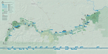 (click for larger map) |
Getting Here Use US 65 or AR 7, 14, or 21. Little Rock, AR, Fayetteville, AR, and Springfield, MO, are two- or three-hour drives from here.
Accommodations Harrison, Jasper, Yellville, Marshall, and elsewhere offer food and lodging. In the park, Buffalo Point has rental cabins and a restaurant open seasonally. Contact Buffalo Point Concessions, 2261 Hwy. 268E, Yellville, AR 72687, or www.buffalopoint.net.
Camping Eleven campgrounds nearby are first-come, first-served. You can reserve some Buffalo Point campsites. Tyler Bend and Buffalo Point campgrounds offer restrooms, showers, and trailer dump stations seasonally. Most Buffalo Point sites have water and electrical hookups. Most campgrounds charge fees, and a reservation is recommended mid-March through mid-November. Services at Tyler Bend and Buffalo Point are limited November through March {dates vary). Camping limit is 14 consecutive days. You must reserve park group sites or pavilions. Make reservations at www.recreation.gov. Campgrounds from Steel Creek to Rush Landing are excellent for beginning or ending float trips. All have toilets. The steep roads to Steel Creek and Kyles Landing are not recommended for trailers, buses, or motor homes. Campground quiet hours are 10 pm to 6 am. Use generators only in developed areas 8 am to 8 pm.
Hiking The park offers hiking year-round. Be cautious in winter when ice/snow may be hazardous and summer when temperatures can be extremely high. Check the weather forecast prior to your arrival and plan accordingly. Hike with a trail map, available at the visitor center, visitor contact stations, and the park website.
Short day-use trails are at Lost Valley, Erbie, Pruitt, Tyler Bend, Buffalo Point, and Rush. More difficult trails are in the Ponca and Lower Buffalo Wilderness areas. Hunting is allowed in the park, so use caution and wear bright clothing when hiking.
Leashed pets are allowed in campgrounds and parking areas, along roads, and on the river and gravel bars. Pets are not allowed in the backcountry or on trails except for Mill Creek Trail and the trai ls surrounding the Buffalo Point Campground (Overlook, Campground, and Forest). Pets must be leashed and/or under physical control at all times. Do not attach your pet to your canoe while floating or leave an unattended pet tied to an object.
Horseback Riding Horseback riding is permitted on many park trails. In the Lower Buffalo Wilderness the trail loop from Hathaway Horse Camp to Cow Creek, from Cow Creek along Buffalo River to Cook Hollow, and then back to Hathaway Horse Camp is a special-use zone. Horses are restricted to established trails there and in the Ponca Wilderness. Elsewhere, horse and stock use is allowed on abandoned roads, gravel bars, old traces, backcountry trails, and shoulders of roads open to motor vehicles. Horses and pack animals are not allowed on front country trails or in areas closed to horses. Primitive camping facilities near Steel Creek, near Erbie, and at Woolum can accommodate trailers.
Interpretive Programs Events in spring and summer at Buffalo Point, Tyler Bend, Pruitt, Ozark, and elsewhere include campfire programs, guided walks and hikes, guided canoe floats, and Ozark folk music. Schedules are at park information stations.
For a Safe Visit Use common sense in this hazardous natural area. • Cell phone coverage in the river corridor is spotty. • Never swim alone or when the river level is high. There are no life-guarded swimming areas. • Diving is extremely dangerous; rocks and logs lie unseen below the surface. • Loose, crumbly rocks or winter ice can make climbing riverside bluffs hazardous. A fall from a bluff is certain injury; getting medical help is difficult and dangerous and may take hours. • Boil all water that does not come from approved sources. • Bury all human waste at least 100 feet from water. Pack out all garbage. • ATV use is prohibited in the park. • Park firearm regulations conform to Arkansas regulations; firearms are prohibited in public buildings. For firearms regulations check the park website. • Consult the Superintendent's Compendium on the park website for any special regulations or restrictions.
To Enrich Your Visit River guides, topographic maps, and books are sold at the visitor center and ranger stations. Purchase Access, Senior, and Annual passes at park headquarters.
Accessibility We strive to make our facilities, services, and programs accessible to all. For information, go to a visitor center, ask a ranger, call, or check our website.
Floating the Buffalo River
Few experiences can compare to a float trip down the Buffalo. Clean waters, high rocky bluffs, wooded hillsides, and myriad wildflowers in season restore the nature enthusiast. Rent canoes nearby. Beginners can float slow-moving sections of the river.
Check with a ranger about river conditions before you set out.
The Buffalo River offers a near-wilderness experience between Carver and Woolum and downstream of Rush Landing. Choose a half-day, 10-day, or 120-mile float or anything in between. Boat motors under 10 hp are allowed only up to the Erbie boat launch.
Before Setting Out
Upstream from Pruitt
whitewater is usually floatable in winter and spring only. Downstream
when the water level is low, Pruitt has riffles, calm pools, and
occasionally fast water. Between Ponca and Kyles Landing use is high,
especially on weekends. Canoe or kayak experience is highly
recommended.
On the lower Buffalo, Rush Landing is the last takeout before entering the Lower Buffalo Wilderness. View the Buffalo National River Services and River Level Guide at www.ar.water.usgs.gov/buffaloriver for river conditions.
Concessioners Park-approved concessioners (see park website) rent canoes, kayaks, rafts, and johnboats and provide all trip needs except personal gear and food. Their brief talks get you and their equipment safely over rapids and down the river, so listen carefully. They also offer shuttle services for both floaters and hikers. Guided johnboat fishing trips serve the middle and lower river. Gear and food can be provided.
River Safety Observe all river warning signs and water safety regulations. • US Coast Guard-approved life jacket required for all vessel occupants and must be worn by children under 13. • Glass containers are prohibited on and near the river. • Keep gear in waterproof containers; stow them low and balanced in your canoe. • If you capsize, stay on the upstream side of the canoe so you do not get pinned between it and river obstacles. • Stay off the river during floodwaters. If rising water threatens, camp where you can move to higher ground—and pull your canoe well out of the water. River rises of a foot or more per hour are common.
Source: NPS Brochure (2018)
|
Establishment Buffalo National River — March 1, 1972 |
For More Information Please Visit The  OFFICIAL NPS WEBSITE |
Documents
A Geospatial Analysis of Safety and Risk Perception in the Buffalo National River (©Julie Nicole Terhune, Master's Thesis University of Arkansas, December 2019)
A Herpetofaunal Inventory of Buffalo National River (Raymond L. Wiggs and Diana Rose Angelo, September 30, 2003)
Accessibility and Self-Evaluation and Transition Plan, Buffalo National River, Arkansas Draft (March 2024)
An Archeological Survey of 18 Miles of Buffalo River Trails, a Parking Lot and Ditch Clean-Out, Searcy and Newton Counties, Arkansas SPEARS Report 90-13 (Carol S. Spears and Teresa A. Turk, February 1991)
An Archeological Survey of the Proposed Buffalo River Trail, Hemmed-in-Hollow, Ponca Area, Newton County, Arkansas and a Reconnaissance of the Henderson Farm Historic Site (Robert D. Jones and Skip Abernathy, September 1979)
Aquatic Invertebrate Monitoring at Buffalo National River, 2005-2013 (David E. Bowles, September 2015)
Archeological Assessment of the Buffalo National River (Daniel Wolfman, May 1979)
Archeological Investigation for Construction of Proposed Skip Emmett Access Road and Survey of Proposed Trailheads and Trail Sections: Buffalo National River, Arkansas (Roger Coleman and Myra Dec, 1988)
Archeological Investigation of the Gilbert Trailhead, Buffalo National River, Arkansas (Roger E. Coleman, 1989)
Archeological Investigations at 3MR80-Area D in the Rush Development Area, Buffalo National River, Arkansas, Vol. I Southwest Cultural Resources Center Professional Report No. 38 (George Sabo III, Randall L. Guendling, W. Fredrick Limp, Margaret J. Guccione, Susan L. Scott, Gayle J. Fritz and Pamela A. Smith, 1990)
Archeological Investigations at 3MR80-Area D in the Rush Development Area, Buffalo National River, Arkansas, Vol. II Southwest Cultural Resources Center Professional Report No. 50 (Randall L. Guendling, George Sabo III, Margaret J. Guccione, Sandra L. Dunavan and Susan L. Scott, December 1992)
Archeological Investigations of the Proposed Pruitt and Tyler Bend Development Areas, Buffalo National River, Arkansas (Jim Bradford, April 1979)
Archeological Prospection Investigations of the Yarborough Open Site #4 (3NW303) at the Steel Creek Horse Camp in Buffalo National River, Newton County, Arkansas Midwest Archeological Center Technical Report Series No. 115 (Steven L. DeVore, and Robert K. Nickel, Caven Clark, Chuck Bitting and Jay Sturdevant, 2008)
Archeological Reconnaissance of the Casey-Clark Tract and Survey of Proposed Trail Segments, Buffalo National River, Newton County, Arkansas (Roger E. Coleman, 1986)
Archeological Significance and Testing at Sites 3NW16 and 3NW41 near Carver Bridge, Newton County, Arkansas, in the Buffalo National River MCRA Report No. 86-6 (Michael C. Sierzchula and Robert H. Lafferty III, April 1987)
Archeological Survey of 13 Acres and Testing in the Boxley Area of the Buffalo National River, Newton County, Arkansas MCRA Report No. 85-9 (Carol S. Spears and Robert H. Lafferty III, November 1985)
Archeological Survey of the Proposed Tyler Bend Access Road, Buffalo National River, Searcy County, Arkansas (Roger E. Coleman, 1987)
Boxley Grist Mill: Reduced Copies of Measured Drawings HAER No. AR-3 (c1986)
Boxley Valley Comprehensive Area Plan, Final Draft Environmental Assessment, Buffalo National River, Arkansas (February 2020)
Buffalo National River Ecosystems: Part I University of Arkansas Water Resources Research Center Publication No. 34 (R.E. Babcock and H.C. MacDonald, 1975)
Buffalo National River Ecosystems: Part IV, Final Report: An Interdisciplinary Study University of Arkansas Water Resources Research Center Publication No. 58 (E.E. Dale, R.L. Meyer, D.G. Parker, E.G. Smith and M.D. Springer, 1978)
Buffalo River Watershed-Based Management Plan (Draft) (FTN Associates, Ltd., December 15, 2017)
Buffalo River Watershed-Based Management Plan (Final) (FTN Associates, Ltd., May 22, 2018)
Carver Bridge: Cultural resources survey of a proposed campground facility at Carver Bridge, Buffalo National River, Newton County, Arkansas Historic Preservation Associates Reports 86-2 (Timothy C. Kingler and Kathleen A. Hinkle, March 1986)
Cultural Affiliation Statement, Buffalo National River (María Nieves Zedeño and Nicholas Laluk, June 1, 2008)
Cultural Landscape Report: Erbie Rural Historic District, Buffalo National River (March 2024)
Cultural Landscape Report and Environmental Assessment, Rush Historic District, Buffalo National River Pubic Review Draft (September 21, 2018)
Cultural Landscapes Inventory: Boxley Valley, Buffalo National River (2010)
Cultural Landscapes Inventory: Collier Homestead, Buffalo National River (1999)
Cultural Landscapes Inventory: Erbie Area, Buffalo National River (2010)
Cultural Landscapes Inventory: Parker-Hickman Log Cabin & Farm (1999)
Cultural Landscapes Inventory: Rush Historic District, Buffalo National River (2012)
Cultural Landscapes Inventory: Valley Y Ranch at Steel Creek, Buffalo National River (2009)
Development Concept Plan: Buffalo Point, Buffalo National River, Arkansas (March 1981)
Development Concept Plan: Buffalo Point, Proposal/Assessment, Buffalo National River, Arkansas (January 1980)
Development Concept Plan: Pruitt, Buffalo National River, Arkansas (March 1981)
Development Concept Plan: Pruitt, Proposal/Assessment, Buffalo National River, Arkansas (January 1980)
Development Concept Plan: Tyler Bend, Buffalo National River, Arkansas (March 1981)
Development Concept Plan: Tyler Bend, Proposal/Assessment, Buffalo National River, Arkansas (January 1980)
Development Concept Plan: Steel Creek-Lost Valley, Buffalo National River, Arkansas (December 1983)
Development Plan/Cultural Landscape Report: Erbie Area, Buffalo National River, Arkansas (May 1986)
Draft Land Protection Plan, Buffalo National River (January 1984)
Elk Management Plan/Environmental Assessment, Buffalo National River, Arkansas (2019)
Fish Community Monitoring at Buffalo National River: 2006 – 2007 Status Report NPS Natural Resource Technical Report NPS/HTLN/NRTR—2009/185 (Hope R. Dodd, March 2009)
Five-Year Review and Recommendations for Revision of Aquatic Sampling Protocols at Buffalo National River and Ozark National Scenic Riverways NPS Natural Resource Report NPS/HTLN/NRR—2012/563 (M.D. DeBacker, D. E. Bowles, H. R. Dodd and L. W. Morrison, August 2012)
Foundation Document, Buffalo National River, Arkansas (October 2018)
Foundation Document Overview, Buffalo National River, Arkansas (October 2018)
Foundation Statement for Buffalo National River, Arkansas (June 2014)
Geologic Map of Buffalo National River: Sheet 1 of 5 (June 2022)
Geologic Map of Buffalo National River: Sheet 2 of 5 (June 2022)
Geologic Map of Buffalo National River: Sheet 3 of 5 (June 2022)
Geologic Map of Buffalo National River: Sheet 4 of 5 (June 2022)
Geologic Map of Buffalo National River: Sheet 5 of 5 (June 2022)
Geologic Resources Inventory Report, Buffalo National River NPS Natural Resource Report NPS/NRSS/GRD/NRR-2022/2413 (Trista Thornberry-Ehrlich, June 2022)
Hicks Hotel and Store: Written Historical and Descriptive Data HALS No. AR-6 (Kimball Erdman, July 2016)
Historic Properties Survey along various Buffalo River Trails, Buffalo National River, in the Ozark Mountain-Arkansas River-Ouachita Mountain Region,, Marion, Newton and Searcy counties, Arkansas Historic Preservation Associates Reports 90-2 (Timothy C. Kingler, Lawrence L. Ayres and James W. Smith, October 1990)
Historic Resource Documentation: Morning Star Mines Interpretive Area, Rush Historic District (Suzanne Rogers, Christopher J. Huggard, Christopher Stratton, Floyd Mansberger and Burnetta Hinterthuer, 2006)
Historic Structures Report: Boxley Grist Mill — Physical History and Analysis Section Final Draft Copy (Thomas Vitanza, ed., November 1991)
If Walls Could Talk: the Story of the Hicks Property, Rush Historic District, Buffalo National River, Arkansas (Kimball Erdman, Angie Payne, Brian Culpepper, Jordan Pitts and Addison Warren, c2016)
Land Acquisition Plan, Buffalo National River Draft (October 15, 1979)
Land Use Plan/Cultural Landscape Report: Boxley Valley, Buffalo National River, Arkansas (June 1985)
Let The River Be: A History of the Ozark's Buffalo River (HTML edition) (Dwight T. Pitcaithley, 1989)
Life, Leisure, and Hardship along the Buffalo National River, Historic Resource Study (Theodore Catton, 2008)
Long-Range Interpretive Plan, Buffalo National River (November 2015)
Master Plan: Buffalo National River, Arkansas (1974)
Methods for Monitoring Fish Communities of Buffalo National River and Ozark National Scenic Riverways in the Ozark Plateaus of Arkansas and Missouri, Version 2.0 NPS Natural Resource Report NPS/HTLN/NRR—2018/1633 (Hope R. Dodd, James C. Petersen, B. G. Justus, David E. Bowles, Gareth Rowell, Lloyd Morrison, Janice A. Hinsey and Jeffrey M. Williams, May 2018)
National Register of Historic Places Nomination Forms
Big Buffalo Valley Historic District (Michael H. Bureman and Craig Frazier, March 1985)
Buffalo River State Park (Jane E. Scott, Dwight T. Pitcaithley and Sandra Taylor-Smith, March 1977, August 1988)
Parker-Hickman Farm Historic District (Jere L. Krakow, February 3, 1987)
Rush Historic District (Suzanne D. Rogers, August 29, 1986)
Park Newspaper (Currents): 2012-2013 • 2016-2017
River Access Study, Buffalo National River, Arkansas Final Report (October 2002)
Proposed Buffalo National River, Arkansas (1968)
Significance Testing of Prehistoric Components at the Edgmon (3NW661), The Luallen (3NW662), and the Sattler Sites (3NW663) in Boxley Valley, Buffalo National River, Newton County, Arkansas SPEARS Report No. 89-6 (Carol S. Spears, Robert A. Taylor and Margaret J. Guccione, July 1989)
Special History Report: Preliminary Survey of Historic Structures, Part I, Buffalo National River, Arkansas (Richard West Sellars, 1973)
Species Abundance, Buffalo National River (by Taxonomy) (undated)
Survey of Prehistoric Cultural Materials of Certain Areas within Buffalo National River, Arkansas (Texas Tech University, May 1975)
The VanDeven Exchange Tract: Cultural Resources Survey and Assessment of the 40 Acre VanDeven Exchange Tract in the Buffalo National River, Newton County, Arkansas Historic Preservation Associates Reports 82-3 (Timothy C. Kingler, August 1982)
Tyler Bend: National Register Assessment of 3SE64, 3SE95, 3SE150 and 3SE188 within the Proposed Tyler Bend Development Area, Buffalo National River, Searcy County, Arkansas Historic Preservation Associates Reports 87-6 (Timothy C. Kingler and Lawrence L. Ayres, March 1987)
Water Quality at the Buffalo National River, Arkansas, 1991-2001 (K.L. White, B.E. Haggard and I. Chaubey, extract from Transactions of the ASAE, Vol. 47 Issue 2, 2004, ©American Society of Agricultural Engineers)
Water Quality Monitoring Plan, Buffalo National River (February 1985)
Wilderness Recommendation, Buffalo National River, Arkansas (March 1975)
Wilderness Recommendation: Draft Environmental Statement, Buffalo National River, Arkansas (1977)
Wilderness Study: Environmental Assessment, Buffalo National River, Arkansas (October 1974)
Boxley Mill Tour (NPS, Duration: 9:53)
Parker-Hickman Farmstead Tour (NPS, Duration: 21:14)
Tales of the Trails: Historic Uses of the Trails at Buffalo National River (Linsey Hughes, Duration: 19:10)
buff/index.htm
Last Updated: 19-Feb-2025