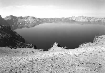

View of the lake from a point on the rim above Grotto Cove.
|
|
Postwar Changes
World War II effectively delayed the full
completion of Rim Drive until the Mission 66 years of park development,
largely because budgets at Crater Lake and elsewhere in the National
Park System remained at barely custodial levels until 1957. At that
point an infusion of project funding began to come as part of preparing
for the fiftieth anniversary of the NPS (to be celebrated in 1966) that
also corresponded to greater annual visitation that drove the need for
new facilities as well as the redesign of existing ones. NPS officials
cited Rim Drive as an outstanding example of past collaboration with BPR
at the beginning of "Mission 66," and they even singled out the park's
road system as illustrating the type of control exerted by the NPS
planning process. Master plans and related documents supposedly guarded
against "whims of opinion or varying methods of development" brought by
changes in personnel.
The "progression of work and revision" guided
by the park's master plan for the most part centered on building new
employee housing at Park Headquarters and developing a campground near
Annie Spring, though a number of smaller projects were also funded by
Mission 66. As for changes along Rim Drive during this period, only the
parking and trail to the lake at Cleetwood Cove merited attention
through revision of the master plan. By the end of Mission 66, however,
the master plans once prepared by resident landscape architects and then
approved by the superintendent and personnel in central offices had
largely given way to sporadic site plans and other assistance supplied
by professional staff stationed away from the park.
Much of the Rim Drive became a one-way system
oriented clockwise beginning in 1971 in response to a management
objective that arose from concern on the part of some in the NPS that
the road between Rim Village and the Diamond Lake Junction had become
too congested. As the greatest change to circulation around the rim
since adoption of the "combination line" between Kerr Notch and Park
Headquarters, the one-way system seemed to create more problems than it
solved. NPS planners stationed in Denver observed that it generated a
greater number of traffic accidents (due to higher vehicle speeds in the
absence of opposing traffic) and many complaints over the sixteen
summers that it remained in force. The supposedly problematic road
segment 7-A opened for two-way traffic again in 1976, so that discussion
of widening that portion of Rim Drive gained momentum. Previous
development at the Watchman Overlook and subsequent reconfiguration of
the Diamond Lake Junction, however, had greater impact on the road as
originally designed and built.
Segment 7-A (Rim Village to Diamond
Lake Junction)
The most pervasive addition of the Mission 66
period along this portion of Rim Drive came in the form of interpretive
panels mounted on bases composed of stone masonry to match the
guardrails. The panels were intended to help make the circuit a
self-guided tour, serving the dual purpose of enhancing visitor
understanding and dispersing use over a wider area away from Rim
Village. Six of the thirteen locations initially chosen for these
devices on Rim Drive fell within this road segment, including the most
elaborate development associated with wayside exhibits, a cluster of
five panels installed during the summer of 1959 at the Diamond Lake
Overlook. More typical were the single panels on bases incorporated
into the masonry guardrails at the Discovery Point parking area, the
Union Peak Overlook, and the Diamond Lake Junction where glacial
scratches can be seen.
Construction of stone bases for the wayside
exhibits began in 1958 under a contract, with work taking place
intermittently through the next four seasons. The five bases built at
the Diamond Lake Overlook were freestanding at first, filling the gaps
originally left for placing boulders between the log barriers. A new
masonry parapet was built to incorporate the bases at this site by 1963,
but it and another section of guardrail added over the following decade
failed to match the original masonry guardrail constructed elsewhere
along Rim Drive.
The interpretive panels proved to be the most
problematic part of wayside exhibits since the routed plastic could not
hold up to direct sun, windblown pumice, moisture, and vandalism.
Routed aluminum soon became the favored material in some locations, but
the NPS began replacing panels with the more durable metalphoto plaques
by 1966. The latter type of interpretive marker lasted for more than
two decades before these were replaced by a new set of fiberglass
exhibit panels beginning in 1987. Neither generation of wayside exhibit
panels, however, achieved the thematic unity in their content as
envisioned by the interpretive concept statement composed for the park's
master plan in 1972.
Initial discussions about adding picnic areas
along Rim Drive took place before the war, during the season of 1939,
when park visitation reached a new high of 225,100 that year. With
attendance steadily increasing, especially during the summer season, to
360,000 by 1956, the onset of Mission 66 represented an opportunity to
go forward with one of the secondary park priorities listed in the
master plan. Day labor leveled and then surfaced six areas around the
rim in 1957, with one located in segment 7-A. It became known as the
Discovery Point Picnic Area once pit toilets and tables built with
concrete ends and redwood lumber had been installed during the summer of
1958. Subsequent development at this picnic area consisted of paving
the parking lot and delineating it with boulders as a control device, in
addition to the inevitable replacement of tables, toilets, and garbage
cans.
The Mission 66 prospectus drafted in 1956
critiqued the parking overlooks and turnouts, particularly those along
segment 7-A, as being too few in number and insufficient in size. As a
means to draw people away from Rim Village, these stopping places needed
increased parking space, especially where views had been enhanced
through the addition of wayside exhibits. This enthusiasm for altering
the size and number of viewpoints along Rim Drive eventually faded, as
the master plan approved in April 1965 restricted its call for
additional parking to the Diamond Lake Junction. Planners from the NPS
service center in San Francisco nevertheless proposed a site study for
the Watchman Overlook after one of them observed its "hazardous
condition" in August 1966. They recommended more formalized parking and
extending the masonry guardrail from the road margin to provide a
measure of safety for visitors who walked to an adjacent ledge for a
view of the lake. A site plan produced several months later thus called
for slight realignment of the road on additional fill so as to
accommodate thirty-nine cars. It also called for "hardening" the
viewpoint with a colored asphalt walk, one whose outer edge would be
bordered by a wall consisting of stone veneer and a concrete
core.
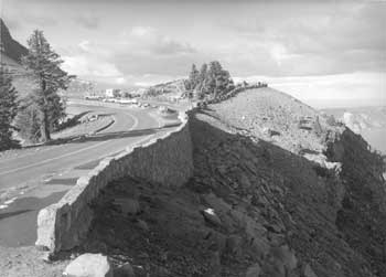
Watchman Overlook.
|
With construction funds in relatively short
supply when compared to the Mission 66 program of just a few years
earlier, the project at Watchman Overlook remained on hold until the
early months of 1971. At that point another site plan suggested
dropping the realignment and reworked the design to yield parking for
thirty cars that could be oriented diagonally in line with the
implementation of a one-way road system. The revised site plan included
new features to Rim Drive such as bituminous curb, contrived rock
"outcrops," and masonry piers linked by pressure treated wood pealer
cores as a safety barrier. Construction at the Watchman Overlook thus
began in 1972, though completion of all items in the contract took
another two summers. As a cue for visitors to stop, the separated
parking and conspicuous design features at the Watchman Overlook quickly
made it the most popular stopping place on Rim Drive, even if most park
employees expressed little hesitation in referring to the locality by
its resulting nickname of the "corrals."
With the resumption of two-way traffic along
segment 7-A, park officials wanted to widen the paved surface of Rim
Drive from 18' to 22', and then 24'. As they explained to engineers
from the Federal Highway Administration (formerly known as the BPR), the
narrow roadway and numerous steep slopes made traveling along this
two-way section hazardous for modern recreational vehicles. The NPS
wanted to keep excavation and the building of new embankments to an
absolute minimum due to costs involved, though this meant widening into
ditches and slopes as steep as 2:1. Realigning the road just south of
the Diamond Lake Junction constituted another aim for the project, one
where the parking areas could be placed along the masonry guardrails so
that visitors would no longer have to walk across Rim Drive from two
parking areas in order to view the lake.
The widening project began in August 1978,
with the first phase covering 2.5 miles over two summers. A second
phase commenced at Station 118 (near the Union Peak Overlook) in 1982
and ran some 3.4 miles north to the Diamond Lake Junction, but excluded
the newly constructed section at the Watchman Overlook. Contractors
realigned the two parking areas, but the "widening" consisted of simply
paving to the edge of existing road shoulders so that vehicle lanes
could be 11' wide. Subsequent striping included the addition of "fog
lines," a feature aimed at providing better visibility for motorists
driving at night or during bad weather.
Realignment of the Diamond Lake Junction came
as part of rehabilitating the North Entrance Road in 1985-87. A new "T"
intersection replaced the original road wye and the new alignment gave
precedence to a through route over continuation of the circuit. It also
came with a new parking area intended to relieve pressure on the parking
areas further south that consistently ranked second in popularity among
all of the viewpoints on Rim Drive. According to NPS justification for
this project, the new parking area was to serve as part of a development
that included hard surfaced walkways allowing for handicapped access to
a pair of overlooks. The design, though still largely conceptual,
called for exhibits and masonry guardrail at the pedestrian viewpoints.
What planners hailed as possessing the
potential to become the most popular stop along Rim Drive soon showed
unsightly wear because the NPS failed to construct the walkways and view
points. Safety concerns led to erection of wood rail fence at the most
conspicuous overlook in 1995, but snow loading dictated an almost annual
replacement of the horizontal members. With little else in place to
restrict visitor impact to this site, overuse had destroyed much of the
vegetation between the parking lot and the rim.
Other changes along segment 7-A also affected
related original designed features in the form of trails, buildings, and
signs. Funding from Mission 66 allowed for contractors to repair parts
of the Discovery Point Trail (a project that included adding masonry
wall near the parking area) and to pave the path leading from an
unsurfaced parking area near the Devil's Backbone to the top of that
volcanic dike. The most ambitious trail project along the west Rim
Drive, however, took place in 1994. It aimed to provide hikers on the
Pacific Crest Trail with an alternative to a route through the park that
followed a series of fire roads and lacked any view of Crater Lake. By
connecting the Discovery Point Trail with pieces of the old Rim Road,
this alternative route required volunteers and day labor to build 2.5
miles of new tread in order for hikers to reach the Diamond Lake
Junction on a trail.
The Sinnott Memorial maintained its
orientation function through the Mission 66 period and beyond, mainly
because the park lacked a permanent visitor center. Such a facility
remained as a top priority on the master plan and its successor, the
general management plan, for the next four decades. The Sinnott
Memorial underwent rehabilitation in 1963 and again in 2001, with a
primary aim of the latter project being to reopen the enclosed museum
that had lapsed into disuse after 1986.
At the Watchman Lookout, meanwhile, the
exhibits in its trailside museum remained in place for only thirteen
years. Removal of the exhibits in 1975 appeared to be triggered by
approval of the interpretive prospectus as part of the master plan three
years earlier, which saw no real need for them. The authors of the next
prospectus in 1980 called for the restoration of the exhibits.
Restoring the lookout begun under the Fee Demonstration Program in 1999
aimed to restore the building's original appearance and initially
included an exhibit component in its scope of work, but cost overruns
after two seasons put the partially completed project on indefinite
hold. The Fee Demonstration program also provided funding for a vault
toilet at the Watchman Overlook in 2001, one of several such facilities
around the park to be faced with stone and topped by a roof
structure.
While the Sinnott Memorial and Watchman
Lookout were maintained (and in some respects, enhanced) for
interpretive use during Mission 66, park employees removed both the
North House and the adjacent checking kiosk at the Diamond Lake Junction
in May 1959. A small parking area next to the site of the North House
remained until the intersection was realigned in 1985, but without a
short trail to the rim. Large boulders eventually took the place of
treated logs to line the island in the road wye, while wood routed signs
indicated direction for motorists instead of the customized markers
built and installed by the CCC. The wood routed signs eventually gave
way in 1995 to brown metal Unicor markers with standardized white
lettering at this and other road junctions throughout the park.
Previously, motorists had to rely on maps and the wayside exhibits to
furnish reference points to find their location on Rim Drive, because
most of the signs that had once marked various localities on the circuit
had disappeared.
Segment 7-B (Diamond Lake Junction to
Grotto Cove)
Even if wayside exhibits seemed to be the most
ubiquitous addition resulting from Mission 66 to Rim Drive, they
remained scarcely in evidence along the northern part of the circuit.
One of these interpretive devices could be seen at the so-called
Cleetwood "backflow," in the masonry guardrail, across from where wind
erosion on the cut slope created during rough grading had resulted in
chronic raveling. The other wayside exhibit attempted to convey the
"story" of soil at Palisade Point, but in a somewhat secluded location
below the masonry guardrail.
Both picnic areas in segment 7-B followed a
standardized road loop designed by the resident landscape architect,
John S. Adams, in March 1957. These sites were placed just over a mile
apart that summer, with another five tables installed down slope of the
parking lot for Cleetwood Cove in 1966. The latter possessed the
largest number of tables at any picnic area on Rim Drive, even though it
remained the most difficult one for visitors to use. In addition to the
walk needed for amenities like toilets and garbage cans situated at the
parking area, the site lacked surfaced paths and shade during the midday
hours.
Development of a new trail to the lakeshore
at Cleetwood Cove with associated parking came in response to the
difficulties associated with an existing trail from Rim Village. In
addition to the existing trail beginning some 900' above the water,
increased annual visitation to the park after World War II made parking
for boat trips and other activities on Crater Lake an additional source
of congestion at Rim Village. Cleetwood Cove, by contrast, offered a
southern exposure (thereby eliminating much of the hand shoveling
required to open a path to the water each spring) and a potential
trailhead only 700' above the lake. Construction of a new trail began in
July 1958 so that it became passable the following summer, but regrading
of steep sections and other work delayed full completion of this day
labor project until September 1962.
Parking at the Cleetwood Cove trailhead
initially consisted of simply widening the road shoulders, but this
solution quickly became inadequate. The resident landscape architect,
Joseph T. Clark, produced a site plan in July 1961 that called for a
parking lot holding 100 cars. He proposed an assembly area at the
trailhead, one to be separated from the road by metal guardrail. The
plan also called for an elongated parking area across Rim Drive from the
trailhead, oriented perpendicular to the road instead of parallel. With
an adequate entranceway, the parking lot site would also be large enough
to allow development of a picnic area with some thirty tables or even a
campground. The initial plan called for a plumbed restroom (comfort
station) and septic system, though this facility and the proposed
drinking fountains depended upon locating a supply of water. In the
absence of springs or other sources, contractors began drilling a well
in 1962. It remained dry even after a second attempt at locating a
potable water supply three years later.
Grading the lot above Cleetwood Cove began in
the fall of 1961, but lack of water effectively limited development of
amenities other than parking to portable toilets and five picnic tables.
These facilities became inadequate as the number of boat tours
increased over the next two decades, so landscape architect Joe Dunstan
sketched several alternatives aimed at relieving poor circulation and
overcrowding in 1991, primarily as a starting point in design. Little
in the way of changes resulted from this effort, with the only
additional development at the site resulting from a spillage problem
associated with fuel delivery to the tour boats. The Fee Demonstration
Program thus funded construction of a fuel transfer building situated
between the parking lot and Rim Drive in 1998.
Segments 7-C and 7-C1 (Grotto Cove to
Kerr Notch)
Placement of wayside exhibits and other
interpretive markers more closely corresponded to the earlier list of
stations and substations in these two road segments than elsewhere on
Rim Drive. All but two substations located between the Wineglass and
Kerr Notch received some type of marker, though in one case (the Grotto
Cove Nature Trail) this type of interpretation persisted for only a
decade. Established in 1968 to promote handicapped accessibility, the
trail made use of small metalphoto plaques mounted on posts along a
masonry guardrail in order to identify plants along a paved walk
originally built as part of the parking overlook. Panels on stone bases
appeared at five other points along segments 7-C and 7-C1 during Mission
66, with the only divergence from this type of marker being a wood
routed signboard placed near the road loop on Cloudcap.
Funding from Mission 66 also brought about
construction of two picnic areas in segment 7-C. One of them, the site
near Skell Head, appeared largely as an afterthought in a dense thicket
of lodgepole pine and thus received little use in comparison to the
other six sites on Rim Drive. Visitors could, by contrast, obtain an
impressive view of Mount Scott and the landscape beyond it from the
other picnic area. Located just one-tenth of a mile from the Mount
Scott trailhead, the name for this picnic area came from the whitebark
pines that provided shade for three tables.
Paving of segment 7-C1 (along with 7-D and
7-E) during Mission 66 in some ways represented belated completion of
the road construction begun more than twenty-five years earlier. In the
interim, the BPR helped the NPS address slides at Anderson Point that
periodically closed the roads, which was the most persistent maintenance
problem on Rim Drive over the first decade or so of the road's
existence. Through a minor change in alignment and measures aimed at
slope stabilization, BPR engineers supervised laborers hired by the NPS
so as to reduce the incidence of future slides at this location over the
summer of 1952. Roughly 100 lineal feet of masonry guardrail replaced
an earlier stone barrier along this section the following year in order
to complete the project.
Segment 7-D (Kerr Notch to Sun
Notch)
Aside from the belated paving of this road
segment in 1960, only one project during the Mission 66 period took
place in this road segment. It came in response to rockfall that
repeatedly damaged, and in some cases, destroyed masonry guardrail along
a section of road along Dutton Cliff in 7-D1. After considering
construction of "rock sheds" to alleviate this problem during the first
part of Mission 66, the NPS let a contract in 1966 to repair some of the
guardrail and retaining wall, in conjunction with establishing some
additional cross drainage in this section of road. Work also involved
replacing damaged sections of the original guardrail with removable
metal posts, a measure dependent upon annual installation by maintenance
crews and one destined to last no more than a few years.
On the other side of Dutton Cliff, along
7-D2, continual slides and rock fall resulted in an attempt to cut the
slope back similar to Anderson Point in the early 1970s. Repairing and
rebuilding masonry guardrail along this so-called "Sun Grade" section
followed in 1985. The park employed day labor rather than contractors
for the latter job, which included rebuilding portions of guardrail that
were located across the road from the slopes composed of glacial
material. Cuts made as part of the original grading contract remained
subject to erosion and raveling, particularly where the slope face
remained wet.
Segment 7-E (Sun Notch to Park
Headquarters)
Aside from one road realignment near the
intersection where Rim Drive terminated at Park Headquarters, virtually
all of the postwar changes in this road segment took place in the
vicinity of Vidae Falls. Development of the Mazama Campground as a major
Mission 66 project turned the attention of park officials away from
overnight facilities below Vidae Falls, though grading for a picnic area
took place in 1958 where the campground road built in concert with
segment 7-E met the old Rim Road. Lack of adequate cross drainage for
the loop road at this picnic area eventually led to rehabilitation of
the site in 2001, a project that included placement of a vault toilet
and new tables. At that point the trailhead for the route to Crater
Peak also became part of the picnic area, largely because parking for
hikers had previously been situated on a blind curve near Tututni Pass.
|
