|
Death Valley
Historic Resource Study A History of Mining |

|
SECTION II:
EARLY MINING DISTRICTS IN THE OWENS AND PANAMINT VALLEYS (continued)
The following is a very brief summary of the development of the mining industry in the Owens and Panamint valley areas west of Death Valley. Although this region is outside the boundaries of the national monument, the districts and camps that once thrived here were precursors of the mining ventures in Death Valley and involved many of the same individuals, both prospectors and investors, who moved freely throughout southern Inyo County. Through the years the growth of these districts were reflections of the same market trends that determined and guided the fortunes of the Death Valley camps. A fuller discussion of Panamint, the first Death Valley-vicinity bonanza town, and of the Panamint Mining District that evolved from it and embraced the first large-scale mining activity within Death Valley proper will follow. This synopsis by no means includes all the early mining districts in the Owens and Panamint valley areas, but deals with the major ones that were contemporaneous, or nearly so, with prospecting efforts in the Panamint and Amargosa ranges.
The first strikes in the Owens and Panamint valleys were made in the early to mid-1860s and centered mostly around the extraction of silver, although lead and gold also appeared in promising amounts. High transportation costs, low yields, expensive machinery unsuited for the job at hand, and falling lead and silver prices soon contributed to the demise of these enterprises. By the late 1870s the earliest southern Inyo camps were already collapsing. Even the arrival of the narrow-gauge Carson and Colorado Railroad at Keeler in 1883, enabling tower freight rates for the Inyo County mines, could not stave off oblivion. In the early 1900s, however, a revival of the mining industry occurred, and old mines were reopened and new prospects were further developed. By 1908 districts in the region all the way from Mazourka Canyon, east of Independence, south were showing explosive activity. The development of electric power in the Sierras, the extension of the standard-gauge Southern Pacific Railroad north from Mojave, and the dawning realization of Inyo County's varied wealth in metals and nonmetals, including gold, silver, lead, copper, zinc, sulphur, graphite, borax, soda, salt, soapstone, talc, magnesium, tungsten, molybdenum, and marble, were all contributing to a growing optimism within the mining community. In the postwar years these valuable commodities could be mined even more profitably by improved processing equipment, which has added stability and certain success to this facet of Inyo County industry.
A. Coso, Russ Telescope Peak and Argus Mining
Districts
1. Darwin French Expedition
The experiences of the '49ers in Death Valley, though made even more horrifying in the retelling, nonetheless served to stimulate the interest of prospectors and miners in Death Valley, the Panamint and Owens valleys, and the Argus and Slate ranges. The tantalizing possibility of relocating the fabulous "Gunsight Lead" not only attracted the ever-inquisitive desert prospector, but also prompted some noteworthy early exploration by organized expeditions.
In the early summer of 1860 Dr. Darwin French and companions, entering from the west, initiated exploration of the Coso Springs and Darwin Wash areas, ultimately penetrating as far east in Death Valley as Furnace Creek Wash, which they are credited with naming. Among the other accomplishments of this group was the discovery of ore near Coso, the creation in the spring of 1860 of the Coso Mining District, and the formation by some of the French party of the Coso Gold and Silver Mining Company. [1]
2. S. G. George and New World Mining and Exploration Company Expeditions
In this same year a group of men led by Dr. S. G. George met and united with the New World Mining and Exploration Company expedition headed by Colonel H. P. Russ, and the two detachments entered the Owens Valley region together. The Union lode was discovered at this time, incorporating the Union, Eclipse, and Ida claims, arid while Russ undertook to organize the Russ Mining District (hailed by one writer as "the first semblance of any form of civil government in the territory now included in Inyo County") [2] and name the Inyo Mountain Range, a subdivision of the George party traveled further east from the Owens Lake area to explore the Panamints.
In the course of their trek they discovered and named Telescope Peak and Wildrose Canyon and explored in the Slate Range. The Christmas Gift antimony mine was discovered in the Wildrose Canyon area, and the Telescope Mining District was also organized at this time. Little actual mining work was done, however. The year 1860 also saw the formation of the Argus District by unknown parties.
3. Indian Depredations and Crude Mining Methods Hinder Development
The further development of any of the mines found during these early forays was hindered by the constant threat of attacks by hostile Piutes who were resentful of the encroachment upon their lands by miners arid settlers in the Owens and Panamint valleys. The frequency and ferocity of their attacks led to the establishment of Camp Independence in the Owens River Valley on 4 July 1862. This action did not deter the Indians, however, who continued to raid and prey on small groups of settlers and miners. Severe retaliation by soldiers and citizens alike culminated in 1865 in the slaughter and drowning of about 100 Indians at the mouth of Owens River. This act broke the resistance of the Piutes, and the way into these fertile and mineral-rich lands was opened for settlers, farmers, and miners. [3]
Before long, however, it was clear that other factors would impose even more detrimental effects on the rapid development of the region: crude mining methods and/or lack of adequate facilities forced the miners to attempt working their ore without roasting it first, and the resulting poor production levels led to the conclusion that the ores in the area were too base to be profitably worked. This, coupled with the isolation, lack of a nearby supply depot, exorbitant transportation charges, and the need for expensive machinery whose acquisition was impossible because of a lack of capital, precipitated an exodus of miners from Inyo County, which lasted until the fabulously-productive Cerro Gordo Mine provided a hint of the vast mineral wealth of the area that was obtainable by more refined and systematic mining methods.
B. Lone Pine Mining District
1. Rise and Fall of Cerro Gordo
Cerro Gordo, on the western slope of the Inyo Mountains about seven miles east of Keeler and thirty miles south of Independence, was the first major silver strike in Owens Valley. Originally a small-scale operation worked by Mexicans between 1862 and 1866, the mine was included in the Lone Pine Mining District organized in April 1866. Three years later Americans took over the property and ultimately turned it into the largest producer of silver and lead in California, yielding ores that assayed at least as high as $300 per ton. [4] In the early 1870s two smelters were erected at Cerro Gordo and one on Owens Lake near the rival town of Swansea. Contributing to Cerro Gordo's commercial success was the fact that this was an excellent area for smelting works: water and wood were abundant, good fire-clay was available, and because of the wide variety of ores in the district, necessary fluxes were obtainable. Productive mines of the area were the historic Union Mine, and the later Cerro Gordo, Cerro Gordo Extension, Estelle, Silver Reef, and Santa Rosa mines. [5] Mule teams transported the ore to Los Angeles, 275 miles away, necessitating high-class ore and bullion in order to make a profit. In 1875 Cerro Gordo suffered a series of setbacks, necessitating the shutdown of its furnaces. These problems resulted from a scarcity of ore in the mine, which had lasted for several months, and the temporary drying up of its water supply; no small factor in the slowdown of production was the litigation that had been initiated in 1870 over ownership of the Union lode. [6] This latter question was finally settled, and on 13 January 1876 the Union Consolidated Mining Company of Cerro Gordo was created and preparations made to return to full-scale production. The revival was not destined to last, however, and by late 1876 and early 1877 the Union Mine appeared to be played out. A fire that raged through some of the mine buildings and the Union shaft was the final straw; the furnaces were closed the following February. A more lethal blow was dealt by falling lead and silver prices, effectively ending this era of activity at Cerro Gordo.
2. Reopening of Cerro Gordo
By 1905 mining activity was reviving in the Panamint region, and hope was seen for many of the old productive mines. Cerro Gordo was purchased by the Great Western Ore Purchasing and Reduction Company, which envisioned building a 100-ton smelter for custom work and also to process ore left on the Cerro Gordo dumps, earlier considered too low grade for the technological methods then in use. By modern methods the ore could be worked profitably. [7]
By 1907 high-grade zinc was found in the old Cerro Gordo stopes, and ore shipments were begun. [8] In 1912 the Cerro Gordo group, whose property now consisted of tunnels and shafts and an aerial tramway connecting the mine with the narrow-gauge Southern Pacific Railroad at Keeler, which had absorbed the old Carson & Colorado, was acquired by Utah mining men. Shipping 1,000 tons of ore daily, Cerro Gordo now became the largest producer of zinc carbonates in the United States. [9] In 1920 about ten men were still employed by the Cerro Gordo mines company and silver-lead ore was being shipped. A few years later, in 1924, silver-lead ore on the old dumps was to be worked by concentration and flotation after five concentrators were installed in the Keeler mill. [10] Gross production of the Cerro Gordo camp from its early profitable years up until 1938 was probably around $17 million. [11] As a sidelight to this story, the old Swansea Mining District, seven miles southeast of Lone Pine and a competitor of Cerro Gordo in the 1860s, was also producing again in 1924 as its old dumps were slowly sampled.
C. Panamint Mining District
1. Panamint City
As if to keep up morale among the mining community in the Panamint Valley, immediately on the heels of the strike at Cerro Gordo erupted the loudest, wildest, most frenzied boom ever to be seen on the west slope of the Panamint Range. It began in January 1873 with the discovery of copper-silver ore in Surprise Canyon. Silver samples assayed as high as $3,000 per ton, with the probable average value of metal-bearing ore being at least $125 a ton. [12] By August 1874 a road had been completed through Panamint Valley and up Surprise Canyon, providing contact with Los Angeles for freighting and supply purposes. The boom lasted only until about 1876 when the two major mines were depleted, but while it lasted memories and legends were created that ensured its place in the history of this region. A more complete narrative concerning Panamint City and the Panamint Mining District follows later in this report.
2. Ballarat
Around 1897 another town in the vicinity of Panamint rose to prominence. This was Ballarat, named for an important Australian gold camp near Melbourne. It was located one-half mile north of Post Office Spring, which had served as a communications center and overnight stop for prospectors during the Panamint boom. The main mine, the Radcliffe, produced 15,000 tons or more of ore from 1898 to 1903. From 1927 to 1942 its tailings were cyanided with a reported recovery value of one quarter of a million dollars in gold. [13] In 1941 the Ballarat Mining and Milling Corporation, a Nevada company, bought property in the Slate and Panamint ranges in San Bernardino and Inyo counties. A Los Angeles company intended to make exhaustive metallurgical tests, paving the way for a projected modern fifty-ton reduction mill south of town to perform custom work. An assay office and metallurgical laboratory were to be part of the complex, [14] and once again Ballarat would see a resurgence of mining activity.
D. New Coso Mining District
1. Darwin
Around 1870 gold, silver, and lead deposits were again discovered in the Coso Range, resulting in formation of the New Coso Mining District circa 1874. Darwin was the main commercial center, and the Defiance the principal mine of the district. Other producers were the Argus-Sterling, Christmas Gift, Lucky Jim, Custer, Independence, Keystone, Thompson, and Wonder. During the period 1870 to 1877 three smelters were erected and water was piped in from the Coso Mountains. By the end of 1875 the town boasted two smelters, twenty working mines, 200 frame houses, seventy-eight business establishments, and a population of 700. [15] In the late 1870s, as was happening in other Inyo County camps, Darwin began to falter in production. The Defiance furnace was shut down in August 1876; all it took to completely depopulate the town were strikes in Bodie and Mammoth City around 1878, and the remaining miners took off for these promising new frontiers.
|
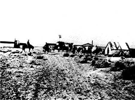
| Illustration 2. Ballarat in 1913, a typical desert mining community. Photo courtesy of Death Valley National Monument. |
|
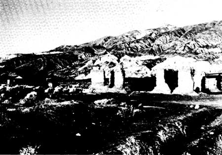
| Illustration 3. Ballarat in November 1973, its adobe ruins slowly sinking back into the sandy desert floor. Photo courtesy of G. William Fiero, University of Nevada at Las Vegas. |
2. Revitalization of the Darwin District
Darwin's rebirth also occurred during the revival of industry in southern Inyo County around 1906. Earlier left on the dumps or not mined because it was considered worthless, copper was now a valuable metal and copper mining was showing unprecedented profits. In 1907 Senator Tasker L. Oddie of Nevada bought nine claims in the Darwin area, while Nixon and Wingfield of Goldfield Consolidated fame also took over some property there. [16] That Darwin had caught the fancy of miners again is evidenced by the statement of one Greenwater miner who said that Darwin's showing of copper was even more promising than that of the famous bonanza town in which he currently lived. [17] Also by 1907 the Lucky Jim Mine was shipping lead-silver ore to Salt Lake smelters. In June 1919 the Darwin District, especially the Lucky Jim and Christmas Gift mines, was still going strong, given impetus by an advance in the price of silver. It was showing up so well, in fact, that in 1920 the stock of the Lucky Jim was placed on the New York Stock Exchange. [18]
By 1927 the Darwin District's future seemed assured, for the area was found to contain ores of nearly all the metallic minerals: silver, lead, gold, tungsten, and copper. Production for the area from 1870 to October 1938 reached approximately $3 to $5 million, [19] some estimates being as high as $7 million by 1945. In that year the Anaconda Copper Mining Company purchased the principal mines and took over operations there. Darwin became the chief source of lead in California, producing two-thirds of all that commodity used in the state. The total value of all lead, silver, and zinc produced has been put at $15 million. [20]
|
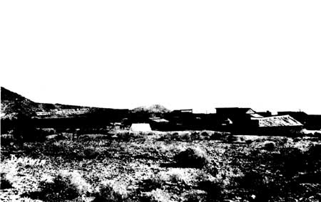
| Illustration 4. Darwin, probably about 1908. This picture might have been taken on the Death Valley Expedition by Veager and Woodward. Photo courtesy of DEVA NM. |
E. Lookout and Modoc Mining
Districts
1. Short Existence of Lookout
While Darwin was flourishing, silver strikes were erupting all over in various areas, notably in the Waucoba District opposite Big Pine in the Inyo Range, in Wildrose Canyon in the Panamint Range, and in the Lee District between Owens Lake and Death Valley. In May 1875 the Lookout District was formed, whose main camp of Lookout consisted only of rock and wood buildings, some general stores, and the ever-present saloons. The Lookout District peaked in 1877 and production soon began to fade.
2. Modoc District Supported by George C. Hearst
From this initial effort, however, the Modoc District was born between 1880 and 1890 on the east slope of the Argus Range, fifteen miles southeast of Darwin. Producing mines were the Minietta and Modoc, the latter, along with the Lookout smelters, having been bought in 1876 by George C. Hearst and other capitalists who proceeded to form the Modoc Consolidated Mines Co. of San Francisco. At first the Modoc, Lookout, and Minietta ores were reduced in the Surprise Valley mill at Panamint City, but in the fall of 1876 Hearst had two thirty-ton furnaces built at the Modoc Mine. Remi Nadeau, freighter for Cerro Gordo and Panamint City, built a road up the Panamint Valley from the foot of the Slate Range to the Modoc and Minietta mines and soon was hauling charcoal by wagons and muleback to the Modoc furnaces from the ten charcoal kilns in Wildrose Canyon.
The Minietta operated on and off until 1915. In 1924 this silver-lead-gold mine was reopened and the Modoc Mine was leased. [21] Their slag piles and dumps were reworked, yielding gold, silver, copper, lead, and zinc. In the mid-1930s the Minietta was leased and refinanced and a mill and modern equipment were to be installed. If gold and silver prices held, the future of the mine seemed bright. [22] By 1938 the Modoc Mine had produced $1,900,000 worth of ore and the Minietta $1,000,000. [23]
F. Summation
These were the principal mining towns and districts of the Owens and Panamint valley regions in the 1800s, none of which had any more exciting and robust a growth than Panamint City. A multitude of books and articles, many listed in the bibliography of this report, have exposed the hardships, dreams, and disappointments experienced by miners and promoters alike in this rip-roaring camp at the head of narrow Surprise Canyon, and it is not the writer's intention to rehash any of this. A brief narrative on the town, however, and the resultant Panamint Mining District, and especially a history of some of its principal mines, many of which bore names similar to later claims in Death Valley, may help clear up some confusion created by this duplication, as well as help determine which properties were located outside the monument boundaries and which were within. (Note: The Panamint Mining District also included the Gold Hill area, immediately northeast of Butte Valley. The history and sites of this region will be treated separately, however, since they are of major importance to this study.)
|
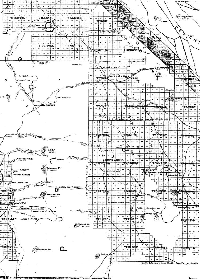
| Illustration 5. "Map of Inyo County Cal." (Segment.) (San Francisco: C.F. Weber & Co., 1914). Courtesy of Bancroft Library, University of California, Berkeley. (click on image for an enlargement in a new window) |
| <<< Previous | <<< Contents >>> | Next >>> |
deva/hrs/section2.htm
Last Updated: 22-Dec-2003