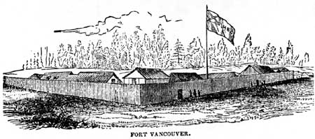
Fort Vancouver
Historic Structures Report
|

|
PLATES

|
|
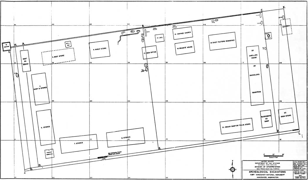
Plate I. Summary Sheet, Archeological Excavations,
Fort Vancouver National Monument, [1947-1952]. (From Louis R.
Caywood, Final Report, Fort Vancouver Excavations, Map No.
11.) (click on image for an enlargement in a new window)
|
|
|
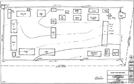
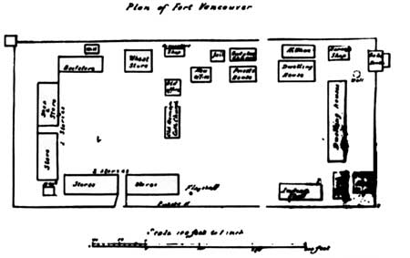
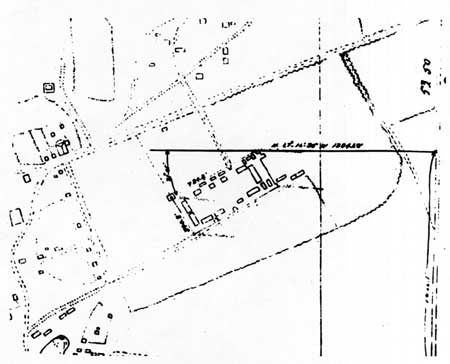
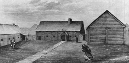
Plate II. Site Plan, Historic Fort Area, Historic
Structures Report, Fort Vancouver National Historic Site, July, 1965.
(National Park Service Drawing No. NHS-VAN) (click on image for an
enlargement in a new window)
|
|
|
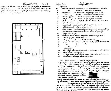
Plate III. Ground Plan of Fort Vancouver, drawn by
George Foster Emmons, July 25, 1841. (From George Foster Emmons,
Journal, MS, III, courtesy Beinecke Rare Book and Manuscript Library,
Yale University)
|
|
|
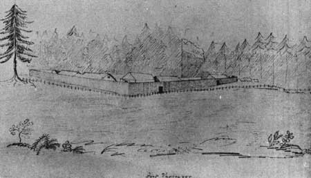
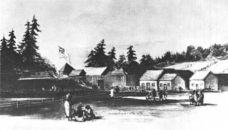
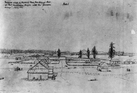
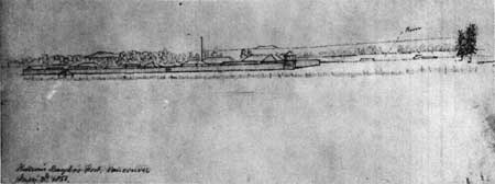
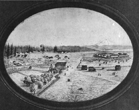
Plate IV. Fort Vancouver from the Southwest, 1841,
drawn by Henry Eld. (From Henry Eld, Journal Statistics, &c, in
Oregon and California, MS; courtesy Beinecke Rare Book and Manuscript
Library, Yale University)
|
|
|
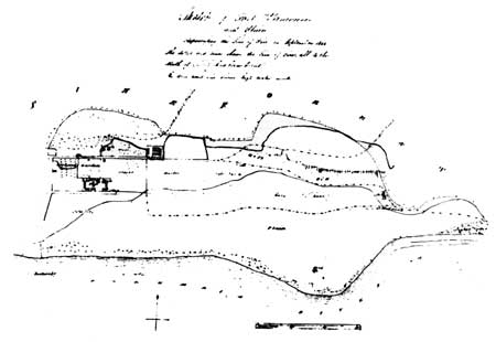
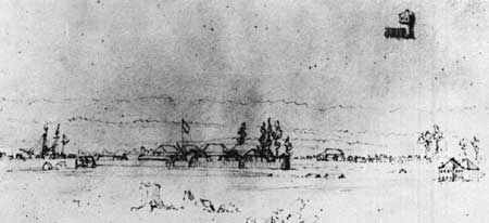
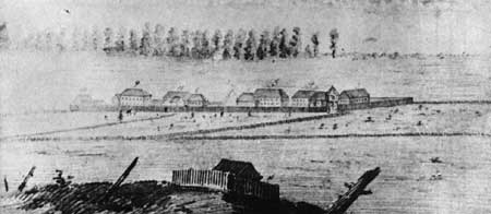
Plate V. Sketch of Fort Vancouver and Plain,
representing the Line of Fire in September, 1844. (From the original
map in the Hudson's Bay Company Archives; reproduced by permission of
the Hudson's Bay Company)
|
|
|
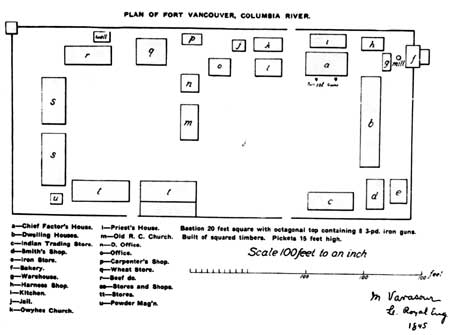
Plate VI. Plan of Fort Vancouver, an inset in "Sketch
of Fort Vancouver and Adjacent Plains," 1845, drawn by M. Vavasour.
(Courtesy of Mr. Howard J. Burnham, of Vancouver,
Washington)
|
|
|
Plate VIII. Version of Vavasour's Plan of Fort
Vancouver, 1845, as redrawn for publication in Oregon Historical
Quarterly. (From Quarterly of the Oregon Historical
Society, X (March, 1909), opposite, p. 100)
|
|
|
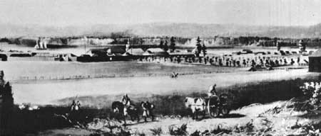
Plate IX. Fort Vancouver from the southeast, 1845,
lithograph based on drawings by Henry J. Warre. (From Henry J.
Warre, Sketches in North America and the Oregon Territory,
[London, 1848])
|
|
|
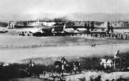
Plate X. Water color sketch of Fort Vancouver, 1845,
by Henry J. Warre. (From the original wash drawing in the Public
Archives of Canada)
|
|
Plate XI. Photograph of an original water color sketch
of Fort Vancouver by Lieutenant T. P. Coode, of H.M.S. Modeste,
probably between June 18, 1846, and May 3, 1847.
This photograph was made in 1928 from the original painting then in
possession of Lieut. (later Vice-Admiral) Coode's son, Rear-Admiral C.
P. R. Coode. The photograph is now in the Hudson's Bay Company
Archives, London. The present location of the original water color is
not known.
(Reproduced by permission of the Hudson's Bay Company)
|
|
Plate XII. Water color copy of Lieutenant T. P.
Coode's water color sketch of Fort Vancouver, 1846-1847.
In 1928 Rear-Admiral C. P. R. Coode lent to the Governor of the Hudson's
Bay Company a water color sketch of Fort Vancouver made by Admiral
Coode's father, Lieutenant T. P. Coode, probably between June 18, 1846
and May 3, 1847. A water color copy of the sketch was made by a Mr.
Kashnor of London, and it is now in the Archives of the Hudson's Bay
Company.
(Reproduced by permission of the Hudson's Bay Company)
|
|
|
Plate VII. Plan of Fort Vancouver, 1845, drawn by M.
Vavasour. (From the original in the Public Record Office, London,
copy courtesy of Mr. Thomas Vaughan)
|
|
|
Plate XIII. Map of Fort Vancouver and Village in 1846,
drawn by R. Covington. (From the original in the Archives of the
Hudson's Bay Company. Reproduced by permission of the Hudson's Bay
Company)
|
|
|
Plate XIV. Pencil sketch of Fort Vancouver from the
northeast, drawn by Paul Kane between December, 1846, and July, 1847.
(From the original sketch in the Ethnology Department, Royal Ontario
Museum)
|
|
|
Plate XV. View of Fort Vancouver from the Northeast,
Painted by an Unknown Artist, Probably about 1847 or 1848. (From the
original painting in the Beinecke Rare Book and Manuscript Library, Yale
University)
|
|
|
Plate XVI. Enlarged Section of Painting of Fort
Vancouver from the Northeast by an Unknown Artist, c. 1847 or 1848.
(From the original painting in the Beinecke Rare Book and Manuscript
Library, Yale University.)
|
|
|
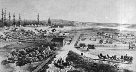
Plate XVII. Fort Vancouver and the Village from the
West, July, 1851. Drawn by George Gibbs. (Smithsonian Institution
National Anthropological Archives, Neg. No. 2854-F-14.)
|
|
|
Plate XVIII. Fort Vancouver from the Northwest, July
2, 1851. Drawn by George Gibbs. (Smithsonian Institution National
Anthropological Archives, Neg. No. 2854-F-15.)
|
|
|
Plate XIX. Section of Plan of Survey of Fort Vancouver
Military Reservation, made in 1854 by Lieut. Col. B. L. E. Bonneville.
(From a photostat in the possession of Mr. Howard J. Burnham,
Vancouver, Washington.)
|
|
|
Plate XX. View of Fort Vancouver from the Northwest,
by an unknown Artist, c. 1854. (Courtesy of Provincial Archives of
British Columbia, Victoria, B. C.)
|
|
|
Plate XXI. Fort Vancouver from the Northwest, 1854.
Drawn by Gustavus Sohon. (From United States, War Department,
Reports of Explorations and Surveys, to Ascertain the Most
Practicable and Economical Route for a Railroad from the Mississippi
River to the Pacific Ocean, vol. XII, plate XLIV.)
|
|
|
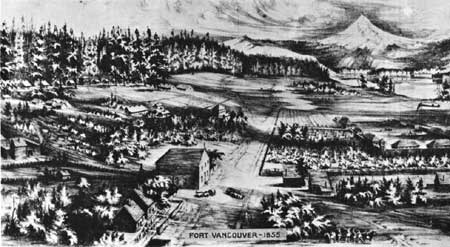
Plate XXII. View of Fort Vancouver from the Northwest,
1855. Drawn by F. Covington. (From photostat in possession of Mr.
Howard J. Burnham, Vancouver, Washington.)
|
|
|
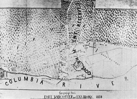
Plate XXIII. Topographical Sketch of Fort Vancouver
and Environs, 1855. (From photostat in possession of Mr. Howard J.
Burnham, Vancouver, Washington.)
|
|
|
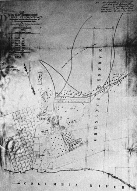
Plate XXIV. Map of the Military Reservation at Fort
Vancouver W. T., Surveyed under the Direction of Capt. Geo. Thom...by
Order of Brig. Gen. W. S. Harney, 1859. (From General Land Office
Records, Abandoned Military Reservation Series, Ft. Vancouver,
Washington, Box 100, in the National Archives.)
|
|
|
Plate XXV. Water Color Sketch of Fort Vancouver from
the North. Painted by J. M. Alden, c. 1859-1860. (From the original
painting in the Beinecke Rare Book and Manuscript Library, Yale
University.)
|
|
|
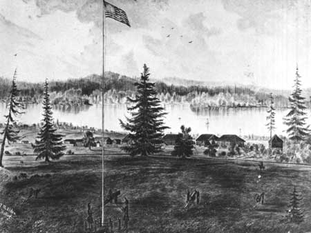
Plate XXVI. Sketch of Fort Vancouver from the
Northwest, c. 1860, by Lieut. John W. Hopkins. (Reproduced, with
permission, from the original ink and wash drawing in the Oregon
Historical Society.)
|
|
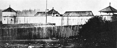
Plate XXVII. Fort Vancouver Courtyard, View toward
Northeast Corner, Photographed by British Boundary Commission Party,
May, 1860.
The buildings visible are, left to right, the Priests' House, the Big
House, and the Bachelors' Quarters. The belfrey is in the center
foreground.
(Courtesy of the Provincial Archives of British Columbia, Victoria,
B. C.)
|
|
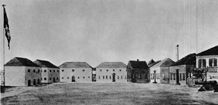
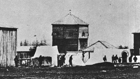
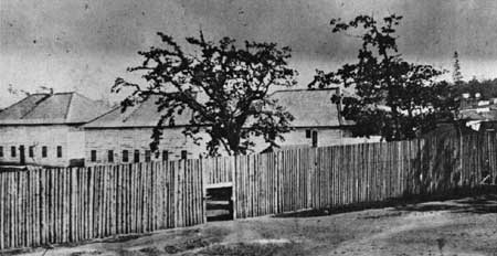
Plate XXVIII. Fort Vancouver Courtyard, View toward
Northwest Corner, Photographed by British Boundary Commission Party,
May, 1860.
The buildings visible are, left to right, the New Store, the sale shop,
an unidentified structure, the root house (with gable roof sloping to
ground level), the bastion, the granary, and the New Office.
(Courtesy of the Provincial Archives of British Columbia, Victoria,
B. C.)
|
|
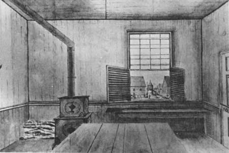
Plate XXIX. The Big House or Chief Factor's Residence,
Fort Vancouver, Photographed by British Boundary Commission Party, May,
1860.
The north and east palisade walls show flat-topped pickets; a
shed-roofed outhouse is visible to the right of the Big House.
(Courtesy Royal Engineers Archives, Brampton Barracks, Kent,
England.)
|
|
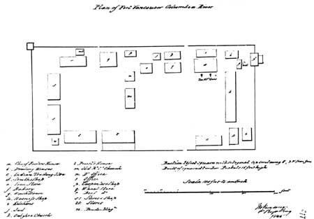
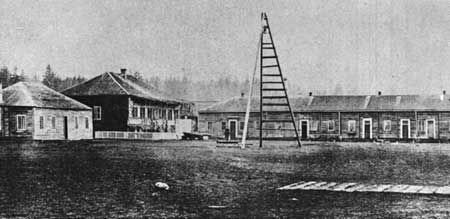
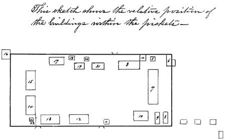
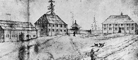
Plate XXX. Ground Plan of Fort Vancouver, June 15,
1860, Drawn by a Board of Army Officers which Evaluated the Buildings
Abandoned by the Hudson's Bay Company on the Previous Day.
The numbered structures were as follows:
3. Governor's House
4. Kitchen (Governor's House)
5. Butcher Shop &c.
6. Bakehouse
7. Quarters for employees
8. Small storehouse
9. Blacksmith shop
10. Fur house
11. Porter's lodge
|
12,13,14. Three large storehouses
15. H. B. Company's store
16. Bastion
17. Granary
18. Carpenter & wheelwright shop
19. Company's office
20. Guard house
21. Dwelling house (formerly Grahame's)
22. Magazine
|
(From Proceedings of a Board of Officers, Fort
Vancouver, W. T., June 15, 1860 MS in A. G. O., Oregon Department,
Document Pile, 212-S-1860, in War Records Division, the National
Archives.)
|
|
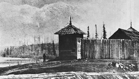
Plate XXXI. Bastion and Stockade at Fort Langley,
British Columbia, 1862.
The stockade pickets are clearly shown with flat tops. They also appear
to be peeled.
(Courtesy of the Provincial Archives of British Columbia,
Victoria.)
|
|
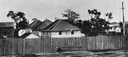
Plate XXXII. Stockade and Buildings of Fort Victoria,
British Columbia, 1858.
The pickets have flat tops and appear to be peeled.
(Courtesy of the Provincial Archives of British Columbia,
Victoria.)
|
|
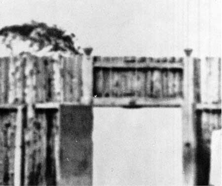
Plate XXXIII. Enlarged Section of Photograph of Fort
Victoria, showing Palisade and Gate Construction.
Notable features include flat-topped pickets, apparently peeled logs,
king posts, and single girth.
(Courtesy of the Provincial Archives of British Columbia,
Victoria.)
|
|
Plate XXXIV. Enlarged Section of 1860 Photograph of
Northwest Stockade Angle, Fort Vancouver, 1860.
The stockade pickets vary in height (compare wall just north of the sale
shop on the left with that between bastion and granary on the right);
posts appear to be flat-topped; king posts seem to be behind pickets
(?); one row of girths.
(Courtesy of Provincial Archives of British Columbia,
Victoria.)
|
|
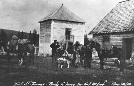
Plate XXXV. Drawing of Fort St. James, British
Columbia, c. 1864-1867, by George Albert Frost.
The palisade posts clearly were pointed at this Hudson's Bay Company
post.
(Courtesy of the Glenbow-Alberta Institute, Calgary,
Alberta.)
|
|
Plate XXXVI. Photograph of Hudson's Bay Company Post,
Fort Rupert, British Columbia.
Outer pickets definitely were pointed; main stockade was topped by a
horizontal timber cap.
(Courtesy of the Provincial Archives of British Columbia,
Victoria.)
|
|
|
Plate XXXVII. Sketch of Fort Langley, 1858, by E. Mallandaine.
(Courtesy of the Provincial Archives of British Columbia, Victoria.)
|
|
|
Plate XXXVIII. Fort Victoria, c.1858, Showing Stockage Exterior
and Gate Entrance. (Courtesy of the Provincial Archives of British Columbia,
Victoria.)
|
|
|
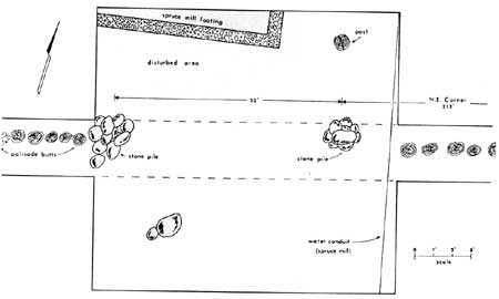
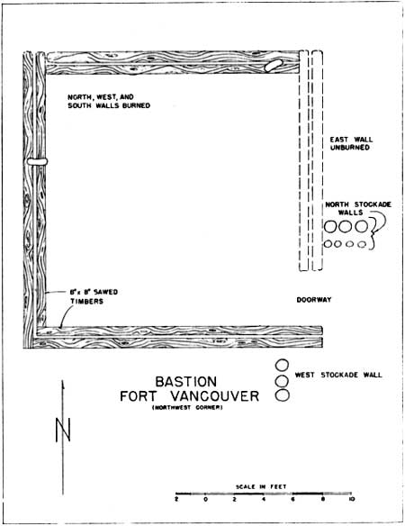
Plate XXXIX. Diagram of North Gate Foundations, Fort Vancouver,
as Excavated in 1966. (From John D. Combes, A Report of the Fort Vancouver Archaeological
Excavations of the North Wall, figure 4.)
|
|
Plate XL. Gate at Fort York, Canada, After
Restoration.
Fort York was a military post, but its gates appear to have been much
like those at Hudson's Bay Company forts in the present British
Columbia.
(From The Beaver, Outfit 265, No. 2 (September, 1934),
56.)
|
|
|
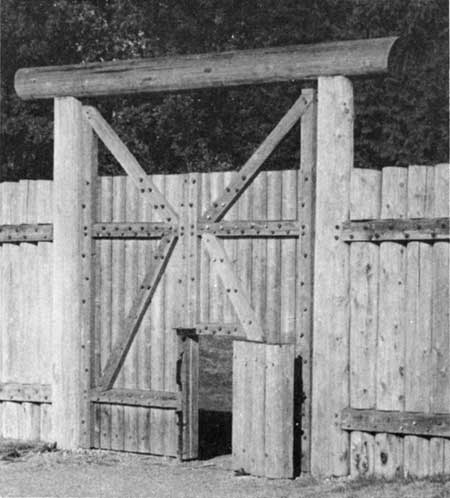
Plate XLI. Reconstructed Gate at Fort Langley, British
Columbia. (National Park Service photograph, by J. A. Hussey, Sept.
9, 1967.)
|
|
|
Plate XLII. Reconstructed Gate at Fort Carlton,
Saskatchewan. (National Park Service photograph by J. A. Hussey,
Sept. 15, 1967.)
|
|
|
Plate XLIII. Plan of Foundation Timbers, Fort
Vancouver Bastion, As Excavated in 1947. (From Louis F. Caywood,
Exploratory Excavations at Fort Vancouver, plate 4.)
|
|
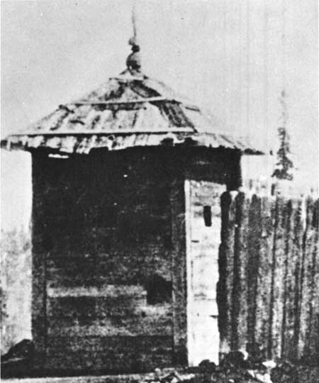
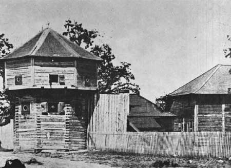
Plate XLIV. Bastion at Fort Langley, British
Columbia.
(Enlarged portion of Photograph NA-1141-1 in the Glenbow-Alberta
Institute, Calgary; reproduced through the courtesy of the
Glenbow-Alberta Institute.)
|
|
Plate XLV. Bastion at Fort Victoria, British
Columbia.
The gun slits are observable as dark lines above each cannon port and
about midway between the lower cannon ports and the ground.
(Courtesy of the Provincial Archives of British Columbia,
Victoria.)
|
|
|
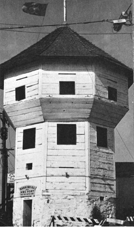
Plate XLVI. Fort Nanaimo Bastion, British Columbia,
1971. (National Park Service photograph by J. A. Hussey, September,
1971.)
|
|
|
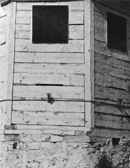
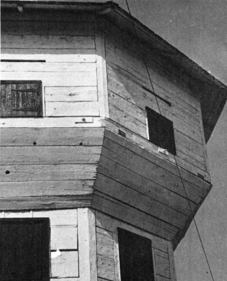
Plate XLVII. Construction Details, Fort Nanaimo
Bastion. (National Park Service photograph by J. A. Hussey,
September, 1971.)
|
|
|
Plate XLVIII. Shutter Details, Fort Nanaimo Bastion.
(National Park Service photograph by J. A. Hussey, September,
1971.)
|
|
Plate XLIX. Fort St. James, British Columbia,
1914.
The structure in the center is the fish store.
(Courtesy of the Provincial Archives of British Columbia,
Victoria.)
|
|
|
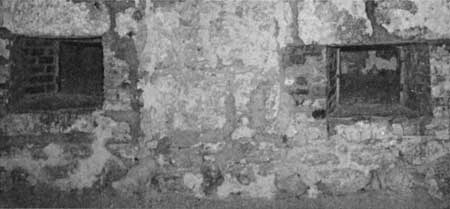
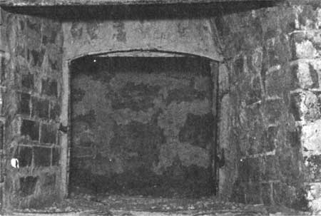
Plate L. Bake Ovens in Bastion, Lower Fort Gerry,
Manitoba. (National Park Service photograph by A. L. Koue, September,
1967.)
|
|
|
Plate LI. Oven Door Detail, Lower Fort Gerry Bakery.
(National Park Service photograph by A. L. Koue, September,
1967.)
|
|
|
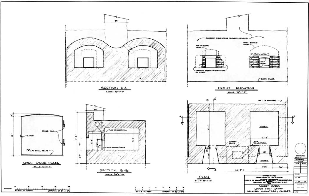
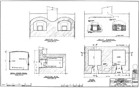
Plate LII. Plan of Bakery Ovens, Lower Fort Gerry.
(National Park Service Drawing by Architect Richard Mehring.)
(click on image for an enlargement in a new window)
|
|
|
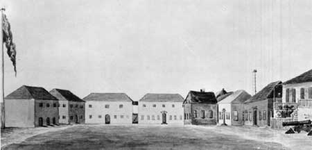
Plate LIII. View of Fort Vancouver from the
Southwest, 1841. (From Charles Wilkes, Narrative of the United
States Exploring Expedition..., IV, 327.)
|
|
|
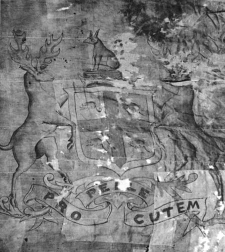
Plate LIV. Hudson's Bay Company House Flag, said to
have flown at Fort Vancouver as early as 1849. (National Park Service
photograph courtesy of Fort Vancouver National Historic Site.)
|
|
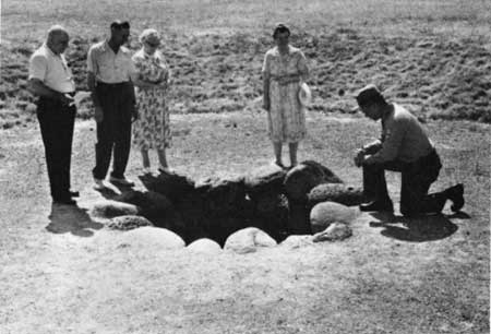
Plate LV. Well No. 2, Fort Vancouver.
This round, boulder-lined well was constructed early in 1845 near the
fort bakery.
(National Park Service photograph, courtesy of Fort Vancouver
National Historic Site.)
|

|
|
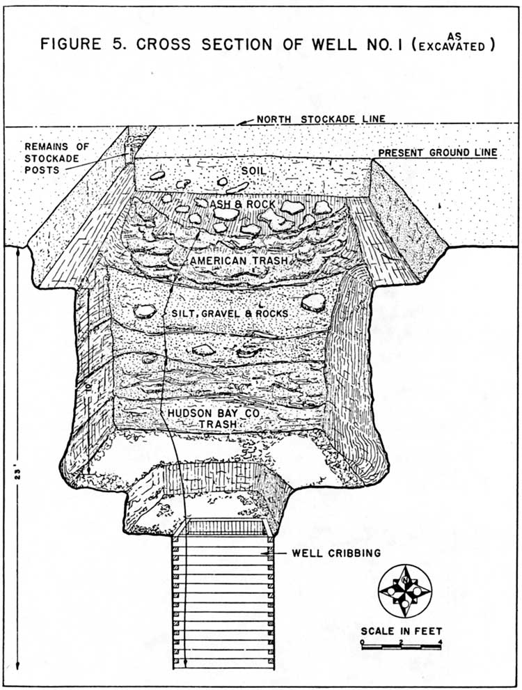
Plate LVI. Cross Section of Well No. 1, Fort
Vancouver, As Revealed by Archeological Excavations in 1952. (From
Louis F. Caywood, Final Report, figure 5.) (click on image for an
enlargement in a new window)
|
|
Plate LVII. Fort Colvile, photographed by the British
Boundary Commission Party, 1860.
The manager's house is the hipped-roof structure to the left.
(Courtesy of the Public Archives of Canada, Ottawa. No. C
19132.)
|
|
Plate LVIII. Jasper House, H. B. C. Post,
1872.
This photograph of a small Hudson's Bay Company structure well
illustrates the technique of applying roof boards.
(Courtesy of the Glenbow-Alberta Institute, Calgary,
Alberta.)
|
|
|
Plate LIX. Roof Detail, Reconstructed Rocky Mountain
House, Heritage Park, Calgary, Alberta. (National Park Service
Photograph by J. A. Hussey, September 24, 1967.)
|
|
|
Plate LX. Weatherboards and Corner Boards, Archway
Warehouse, Norway House. (Photograph courtesy of Mr. Terence B.
Smythe, National Historic Sites Service, Canada.)
|
|
|
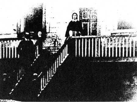
Plate LXI. Front Stairway and Entrance, Officers'
Quarters, Fort Langley, c.1858-1874. (From The Beaver, Outfit
289 (Autumn, 1958), 36.)
|
|
|
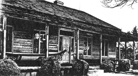
Plate LXII. Restored Factor's House, Fort Nisqually.
(From The Beaver, Outfit 292 (Summer, 1961), 15.)
|
|
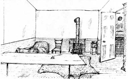
Plate LXIII. Room in the Great Hall, Fort William,
1816.
This drawing is said to have been made by Lord Selkirk shortly after he
captured the North West Company's great depot in 1816. Dr. McLoughlin
served the North West Company at that post and undoubtedly ideas
absorbed there concerning con struction methods were later employed at
Fort Vancouver.
(Courtesy of Public Archives of Ontario, Toronto, from Selkirk
Papers, Pkg. 21, #126. Photograph lent for this study by Mr. Erwin N.
Thompson.)
|
|
|
Plate LXIV. Sitting Room Interior, Staff House, Moose
Factory, Hudson Bay. (Courtesy of Library, Hudson's Bay Company,
Winnipeg; reproduced with permission of the Hudson's Bay
Company.)
|
|
|
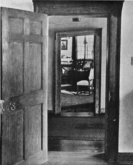
Plate LXV. Interior Doorways, Governor's House, Lower
Fort Garry, c.1935. (From The Beaver, Outfit 266, No. 3
(December, 1935), [34].)
|
|
|
Plate LXVI. Moose Factory, 1878. (From The
Beaver, Outfit 277 (June, 1946), [26].)
|
|
|
Plate LXVII. View of a Room, Presumably in Upper or
Lower Port Garry, c.1846-1848, Drawn by George B. Finley. (Courtesy
of the Glenbow-Alberta Institute, Calgary, Alberta. Fig.
58.24.75.)
|
|
|
Plate LXVIII. Blacksmith Shop, Moose Factory, c.1946.
(Courtesy of Library, Hudson's Bay Company, Winnipeg; reproduced with
permission of the Hudson's Bay Company.)
|
|
|
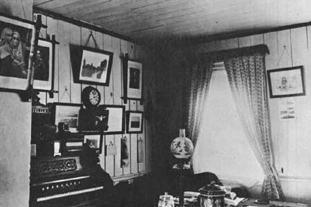
Plate LXIX. Drawing Room, Governor's House, Lower Fort
Garry, c.1935. (From The Beaver, Outfit 266, No. 3 (December,
1935), 37.)
|
|
|
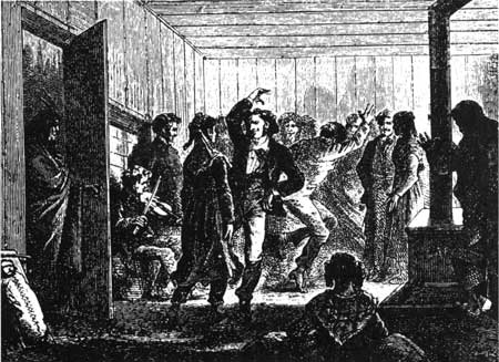
Plate LXX. Christmas Dance in Bachelors' Hall, York
Factory, 1840's. (From R. M. Ballantyne, Hudson Bay.)
|
|
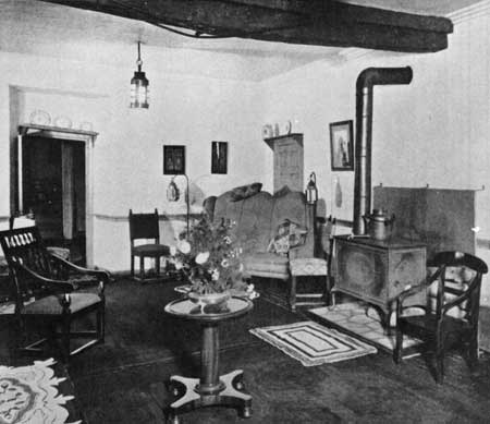
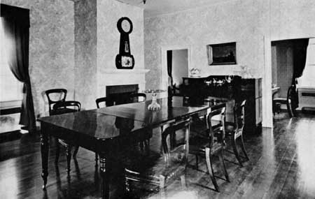
Plate LXXI. Dining Room, McLoughlin House National
Historic Site, 1941.
The dining table and chairs are said to have belonged to Dr. John
McLoughlin at Fort Vancouver.
(National Park Service photograph by Baychuck Studio, Portland,
Oregon.)
|
|
|
|
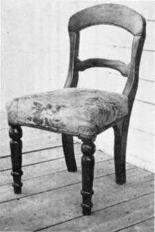
Plate LXXII. "Country Made" Chair, Front View, Moose
Factory. (Courtesy of Library, Hudson's Bay Company, Winnipeg;
reproduced with permission of the Hudson's Bay Company.)
|
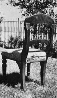
Plate LXXIII. "Country Made" Chair, Rear View, Moose
Factory. (Courtesy of Library, Hudson's Bay Company, Winnipeg;
reproduced with permission of the Hudson's Bay Company.)
|
|
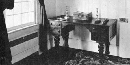
Plate LXXIV. "Dr. McLoughlin's Desk," McLoughlin House
National Historic Site, 1941.
This desk is said to have been used by Dr. John McLoughlin at Fort
Vancouver.
(National Park Service photograph, by George Grant.)
|
|
|
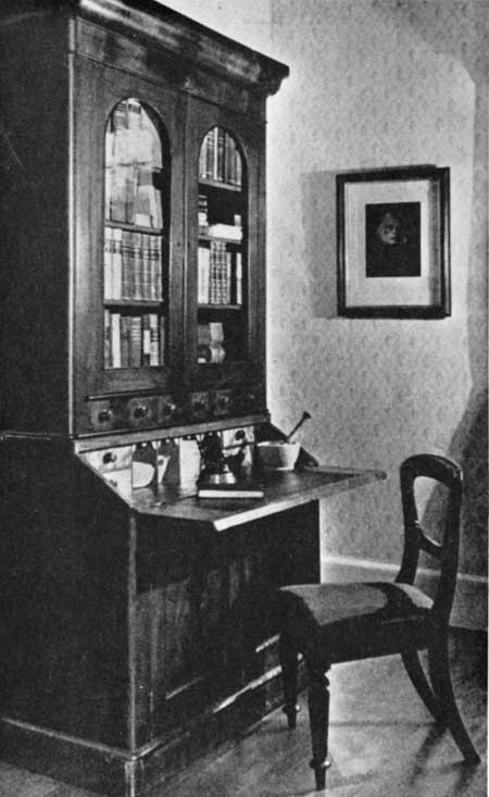
Plate LXXV. Secretary "from Fort Vancouver,"
McLoughlin House National Historic Site, 1941. (From The
Beaver, Outfit 272 (September, 1941), 33.)
|
|
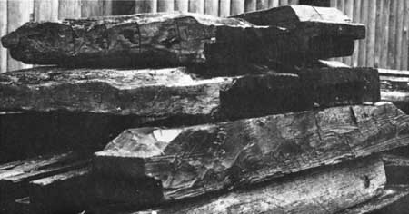
Plate LXXVI. Assorted Timbers from Original Fort
Victoria Cook House, Fort Victoria Museum, 1967.
A grooved corner post is clearly visible in the center of the picture.
The thinner "filler" timbers are ranged to the left.
(National Park Service photograph by J. A. Hussey, October,
1967.)
|
|
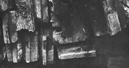
Plate LXXVII. Horizontal "Filler" Timbers from
Original Fort Victoria Cook House, Fort Victoria Museum, 1967.
The shape and finish of these timbers are characteristic of Hudson's Bay
Company construction across the continent. The right-angled side of the
tenon faced the outside of the wall; the beveled side was toward the
inside of the structure.
(National Park Service photograph by J. A. Hussey, October,
1967.)
|
|
|
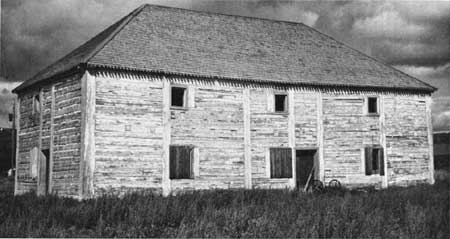
Plate LXXVIII. British Columbia. Old Hudson's Bay
Company Warehouse, Fort St. James, (National Park Service photograph
by J. A. Hussey, September, 1967.)
|
|
|
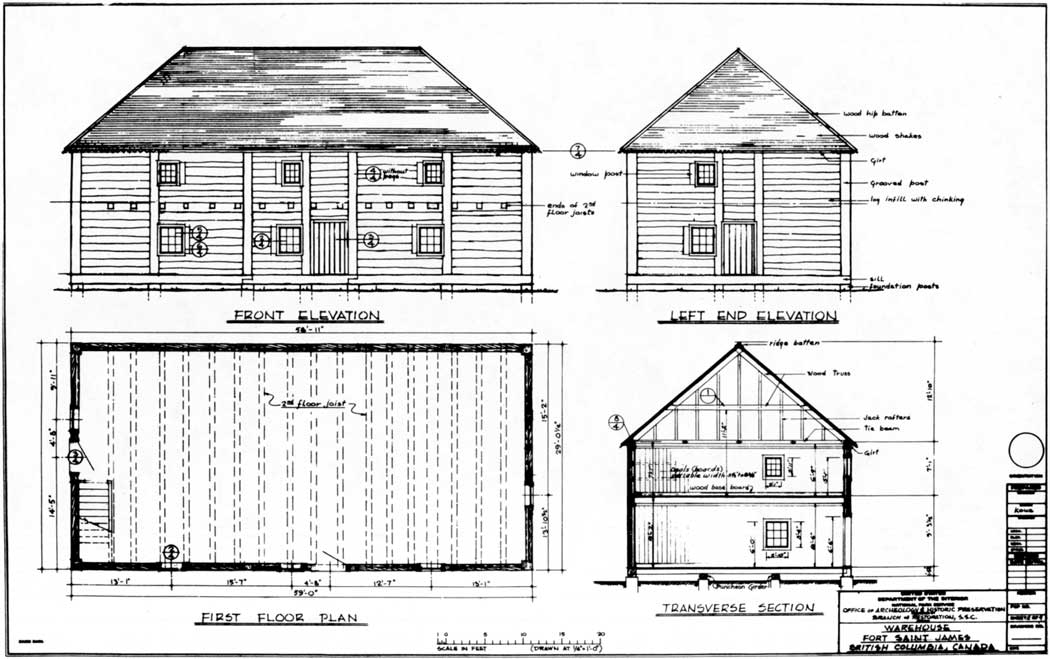
Plate LXXIX. Measured Drawings, H. B. C.
Warehouse, Fort St. James, Sheet 2. (National Park Service drawing by
Historic Architect A. L. Koue.) (click on image for an enlargement in a
new window)
|
|
|
Plate LXXX. Measured Drawings, H. B. C. Warehouse,
Fort St. James, Sheet 3. (National Park Service drawing by Historic
Architect A. L. Koue.) (click on image for an enlargement in a new
window)
|
|
|
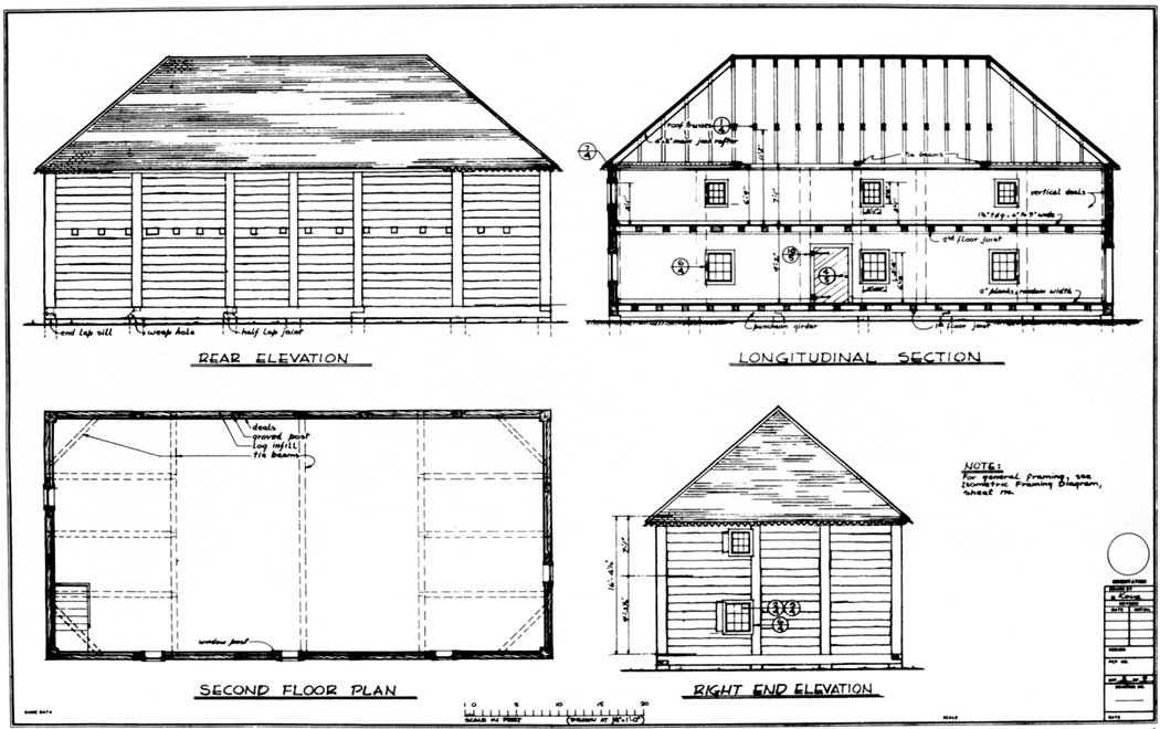
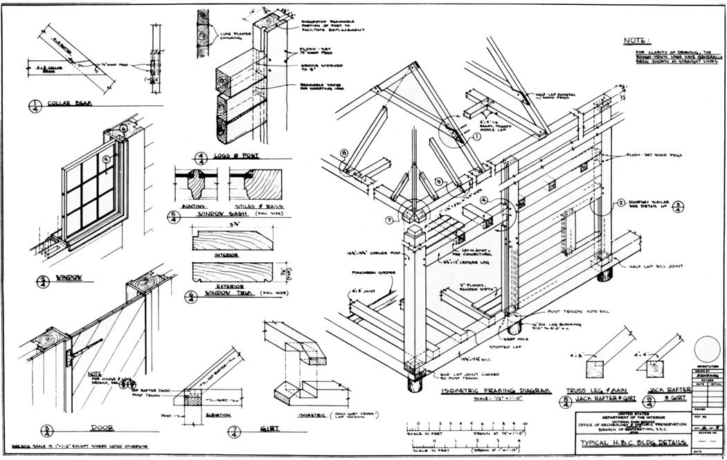
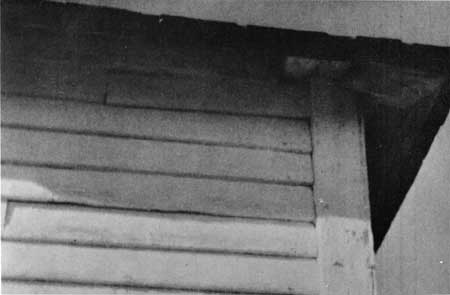
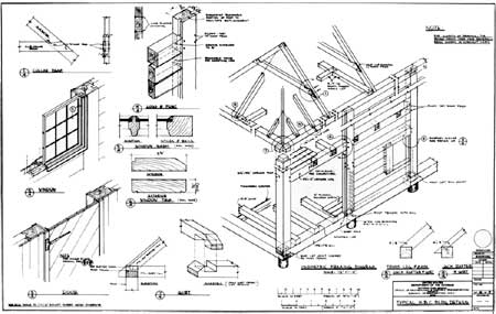
Plate LXXXI. Typical H. B. C. Building Details,
Warehouse, Fort St. James, Sheet 4. (National Park Service drawing by
Architect F. Mehring, based on measurements by A. L. Koue, September,
1967.) (click on image for an enlargement in a new window)
|
|
|
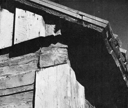
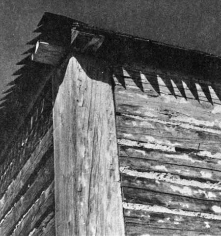
Plate LXXXII. Eaves Detail, Warehouse, Fort St.
James. (National Park Service photograph by J. A. Hussey,
September, 1967.)
|
|
|
|
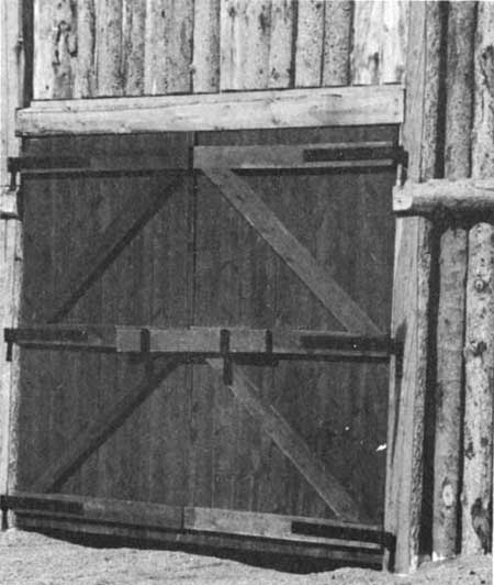
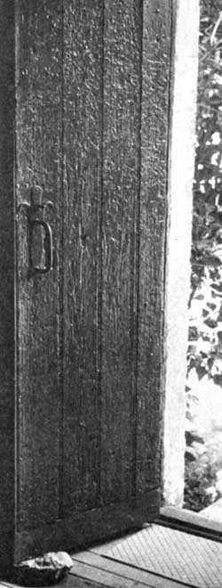
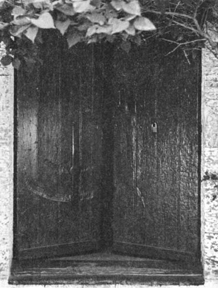
Plate LXXXIII. One-Half of Trade Shop Double Door, Lower Fort Garry, Manitoba.
(National Park Service photograph by J. A. Hussey,
September, 1967.)
|
|
|
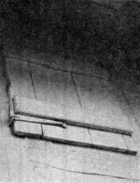
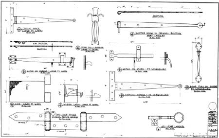
Plate LXXXVI. Shutter on Upper Story Window on Only
Surviving H. B. C. Building, Fort Langley, B. C. (National Park
Service photograph by A. L. Koue, September, 1967.)
|
Plate LXXXVII. Shutter on Lower Story Window,
Surviving Original H. B. C. Structure, Fort Langley.
The hinges are 13-1/2 inches long overall.
(National Park Service photograph by J. A. Hussey, September,
1967.)
|
|
|
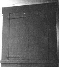
Plate LXXXIV. Main Door, H. B. C. Warehouse, Fort St.
James. (National Park Service photograph by J. A. Hussety, September,
1967.)
|
|
|
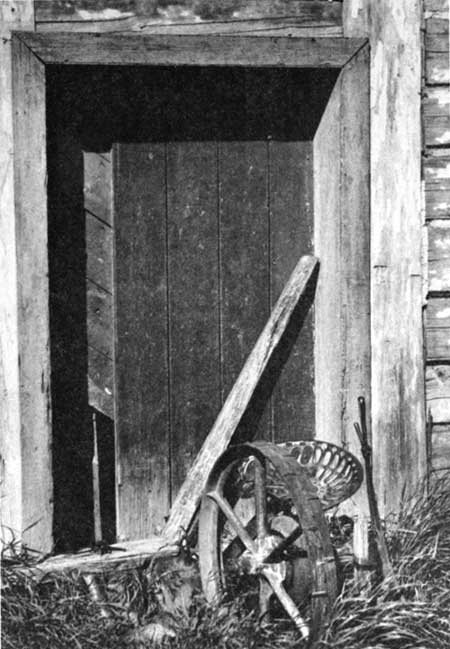
Plate LXXXV. Double Door, H. B. C. Warehouse, Lower
Fort Garry. (National Park Service photograph by J. A. Hussey,
September, 1967.)
|
|
Plate LXXXVIII. "Athabasca Building," H. B. C.
Warehouse, Port Edmonton, Alberta, c.1900 (?).
(Alberta Government Photograph, from the Ernest Brown Collection,
Department of Industry and Development, Edmonton, Alberta. Neg. No.
B1062.)
|
|
|
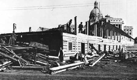
Plate LXXXIX. Tearing Down the "Athabasca Building,"
Fort Edmonton, October 14, 1915. (Courtesy of the Glenbow-Alberta
Institute, Calgary, Alberta. File No. NC-6-1544.)
|
|
|
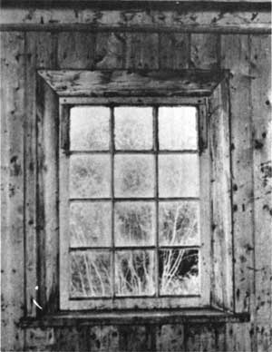
Plate XC. Warehouse Window, York Factory, c.1970.
(Courtesy of Technical Services Branch, Department of Indian Affairs
and Northern Development, Ottawa.)
|
|
|
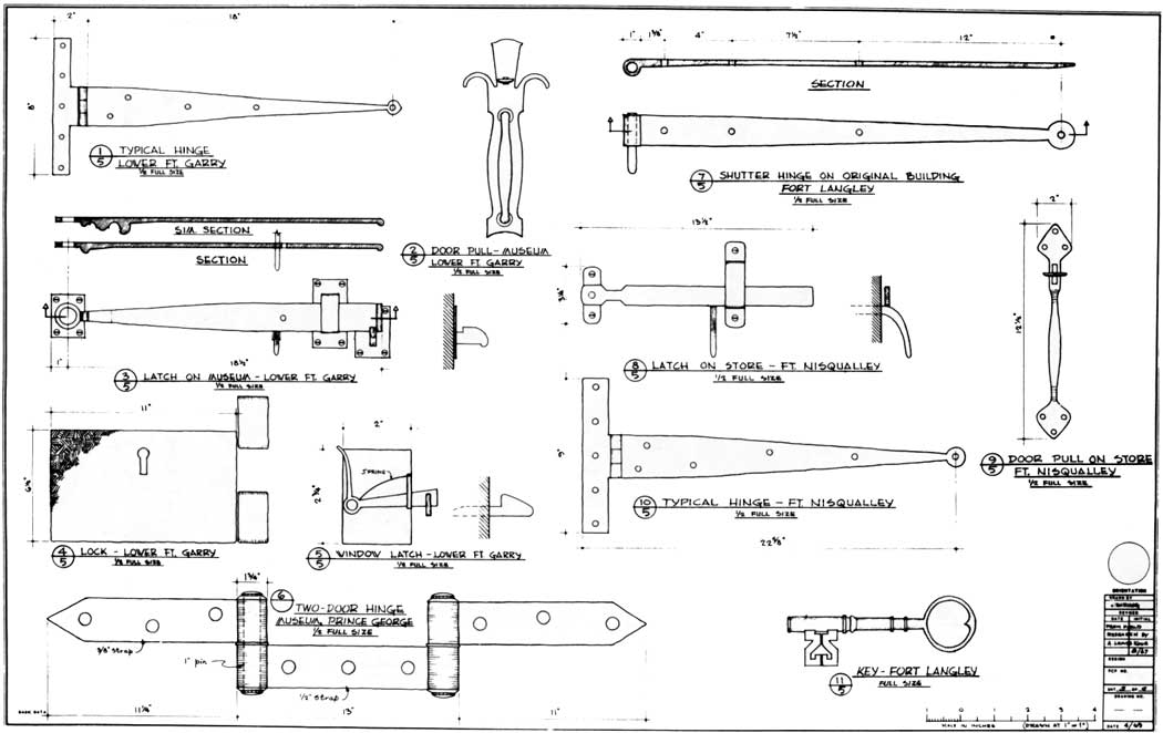
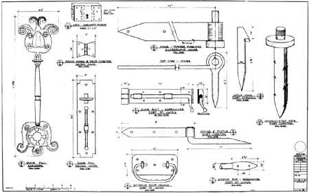
Plate XCI. Typical Hardware, H. B. C. Structures,
Sheet 5. (National Park Service drawing by F. Mehring, based on field
data by A. L. Koue, April, 1969.) (click on image for an enlargement in
a new window)
|
|
|
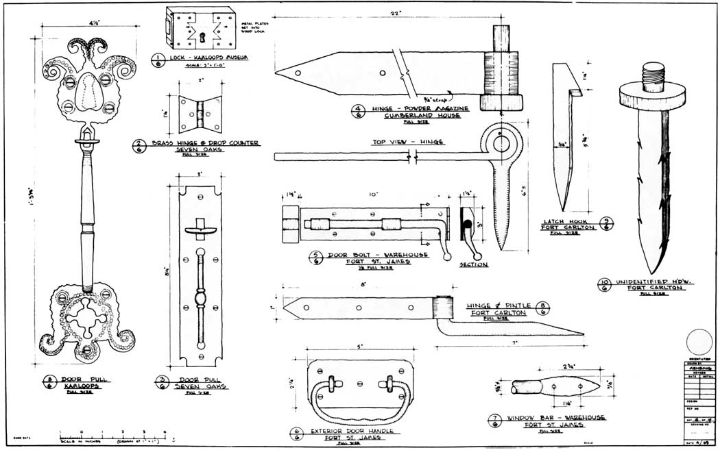
Plate XCII. Typical Hardware, H. B. C. Structures,
Sheet 6. (National Park Service drawing by R. Mehring, based on field
data by A. L. Koue, April, 1969.) (click on image for an enlargement in
a new window)
|
|
|
|
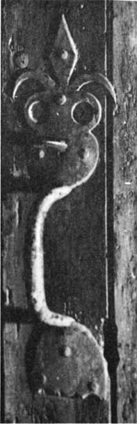
Plate XCIII. Latch on Warehouse Door, York Factory,
Hudson Bay, c.1970. (Courtesy of Technical Services Branch,
Department of Indian Affairs and Northern Development, Ottawa.)
|
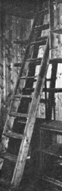
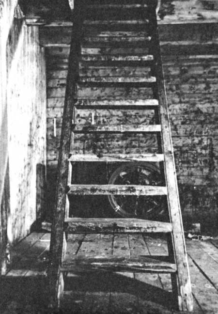
Plate XCVII. Shelves and Ladder in Shop or Warehouse,
York Factory, c.1970. (Courtesy of Technical Services Branch,
Department of Indian Affairs and Northern Development, Ottawa.)
|
|
|
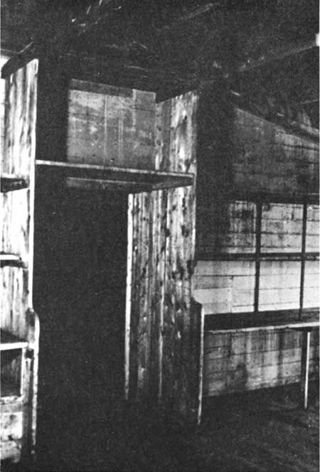
Plate XCIV. Stairway in Warehouse, York Factory,
c.1970. (Courtesy of Technical Services Branch, Department of Indian
Affairs and Northern Development, Ottawa.)
|
|
|
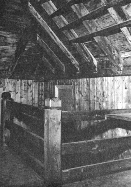
Plate XCV. Protective Railing Around Stairway Opening
on Second Floor of Warehouse, York Factory, c.1970. (Courtesy of
Technical Services Branch, Department of Indian Affairs and Northern
Development, Ottawa.)
|
|
|
Plate XCVI. Shelves in an Old Structure at York
Factory, c.1970. (Courtesy of Technical Services Branch, Department
of Indian Affairs and Northern Development, Ottawa.)
|
|
|
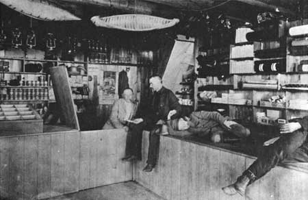
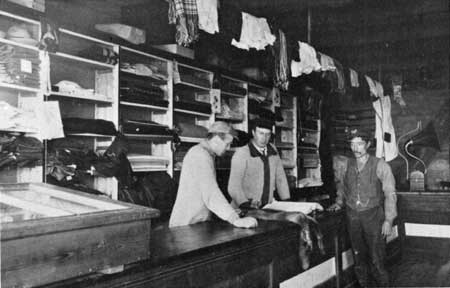
Plate XCVIII. Interior of an Unidentified H. B. C.
Trading Store. ( Courtesy of Library, Hudson's Bay Company, Winnipeg;
reproduced with permission of the Hudson's Bay Company.)
|
|
|
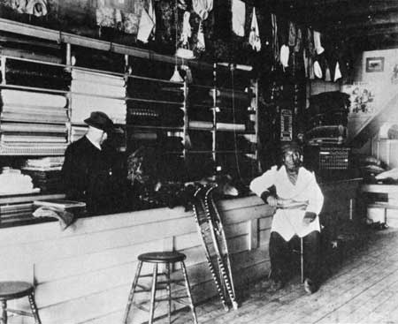
Plate XCIX. Hudson's Bay Company Trade Shop at Fort
Resolution. (Courtesy of Library, Hudson's Bay Company, Winnipeg;
reproduced with permission of the Hudson's Bay Company.)
|
|
|
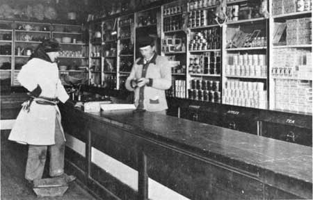
Plate C. Interior of Trade Shop, Fort Resolution.
(Courtesy of Library, Hudson's Bay Company, Winnipeg; reproduced with
permission of the Hudson's Bay Company.)
|
|
|
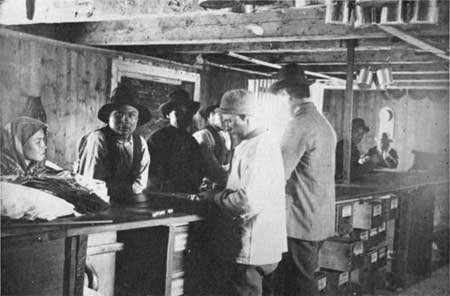
Plate CI. Interior of Hudson's Bay Company Store,
Fort Vermilion, c. 1910. (Courtesy of the Glenbow-Alberta Institute,
Calgary, Alberta. File No. NA-1315-27.) (click on image for an
enlargement in a new window)
|
|
|
Plate CII. Interior of H. B. C. Store at Lac Seul,
Ontario, Early 20th Century. (Courtesy of Library, Hudson's Bay
Company, Winnipeg; reproduced with permission of the Hudson's Bay
Company.) (click on image for an enlargement in a new window)
|
|
|
Plate CIII. Interior of H. B. C. Trading Store,
Albany, Hudson Bay, c.1905. (Courtesy of Library, Hudson's Bay
Company, Winnipeg; reproduced with permission of the Hudson's Bay
Company.)
|
|
|
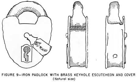
Plate CIV. Iron Padlock Excavated at Fort Vancouver.
(From Caywood, Final Report, Figure 9.)
|
|
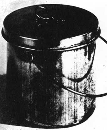
Plate CV. A "Covered Copper Kettle" of the Type Sold
at Hudson's Bay Company Shops During the Nineteenth Century.
Photograph of a specimen formerly in the Company's museum.
(From The Beaver, Outfit 287 (Summer, 1956), 50.)
|
|
|
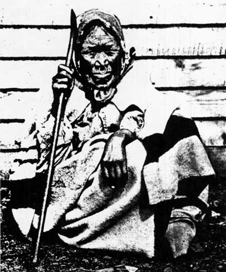
Plate CVI. Haida Woman Wearing a Hudson's Bay Company
"Point" Blanket, 1880's. (From The Beaver, Outfit 287 (Summer,
1956), 51.)
|

|
Plate CVII. Tobacco for the Fur Trade.
The items illustrated are, from left to right, a one-pound twist, a
one-pound carrot, and a three-pound carrot.
(From The Beaver, Outfit 274 (March, 1944), 36.)
|
|
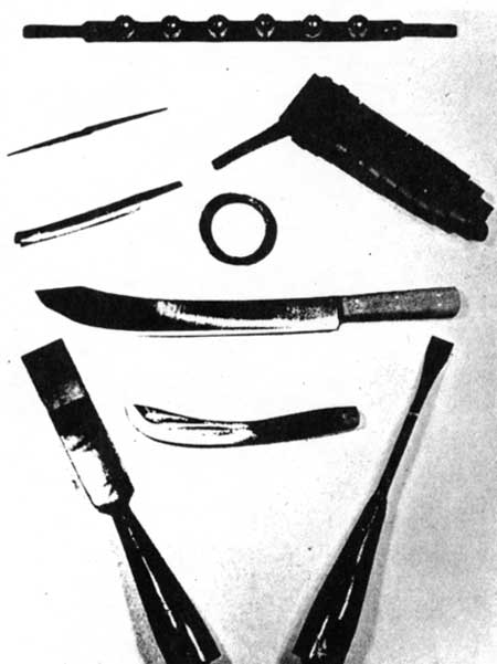
Plate CVIII. Sales Items Long Carried at H. B. C.
Sales Shops Across the Continent.
The objects shown, front left to right, are dogbells, canoe awl, crooked
knife, tumpline, snare wire, snow knife, skinning knife, and ice
chisels.
(From The Beaver, Outfit 274 (March, 1944), [33].)
|
|
|
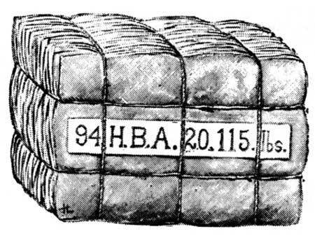
Plate CIX. An H. B. C. Fur Pack, 1895. From Casper
Whitney, On Snow-Shoes to the Barren Grounds, 295; photograph
courtesy of the Glenbow-Alberta Institute, Calgary, Alberta. File No.
NA-1185-14.)
|
|
|
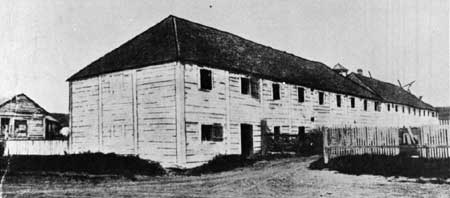
Plate CXI. Original H. B. C. Granary, Fort Nisqually,
Washington. (Courtesy Photographic Records Office, The National
Archives.)
|
|
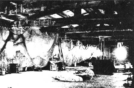
Plate CXII. The Great Store Room on the Second Floor
Back of the Depot at York Factory, 1923.
This building was constructed during the 1840's.
(Photograph by Martin Bovey, from The Beaver, Outfit 288
(Winter, 1957), 16.)
|
fova/hsr/plates-1.htm
Last Updated: 10-Apr-2003
|