![]()
MENU
![]() Navajo
Navajo
|
Glimpses of Our National Monuments NAVAJO NATIONAL MONUMENT |
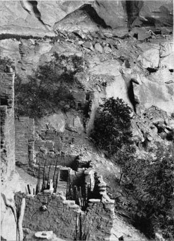
Part of Betatakin ruin before excavation.
The Navajo National Monument is in northeastern Arizona, with in the great but little known Navajo Indian Reservation. It was created March 20, 1909, and the area reduced by presidential proclamation of March 14, 1912, to three small areas totaling about 360 acres. Each separate tract contains the ruins of a remarkable pre-historic cave pueblo or cliff dwelling in good state of preservation. These are known as Betatakin, a Navajo name meaning sidehill house, Kitsil (meaning broken pottery), and Inscription House. The latter ruin derives its name from an inscription scratched into the clay plaster of a wall. It reads, "S—hapeiro Ano Dom 1661." An intrepid early Spanish explorer or missionary, probably on his way to or from the Colorado River, must have entered the canyon in which this ruin is located and paused at the long-abandoned pueblo to scratch a record of his visit. So far as recorded it was not visited again until June, 1909.
Betatakin, the only ruin in the monument which has been excavated and restored, was discovered by Prof. Byron Cummings in 1909. It is situated at an elevation of 7,000 feet, in a great cave 450 feet long with a maximum depth of 150 feet, in the side of a soft, red sandstone cliff which forms the north wall of a most picturesque and beautiful canyon. The cave roof projects far out over the village, which originally contained more than 130 ground-floor rooms and occupied every foot of available building space. Sand storms had piled among the central rooms an accumulation in which oaks 4 inches in diameter and varied shrubbery had taken root. In the canyon fronting Betatakin are tall, slender quaking aspen, alder, and birch; pines deck the talus slopes; cedar and pinon cap the bordering cliffs. Betatakin was restored for the Interior Department in the spring of 1917 by Neil M. Judd, of the Smithsonian Institution.
Kitsil, the largest of the three cave pueblos, is appropriately named, as the open spaces between the apartments are strewn with broken pottery of the finest type produced by the ancient cliff dwellers. The village completely filled a cave 350 feet long and 50 feet deep and included over 250 rooms. Several circular ceremonial chambers or kivas at the front of the cave and below the general building level indicate the clans occupying it differed from those living at Betatakin, as in the latter ceremonial rooms are square or rectangular. Kitsil is situated in a wooded canyon, the walls of which are warmly colored. The rich greens of the foliage and bright flowers create a picturesque setting in an atmosphere of peace and simplicity. Within recent years, however, floods have so eroded the canyon that the horseback trip to Kitsil from Kayenta should be made only under guidance of one thoroughly familiar with the trail and its quicksands.
Nitsie Canyon, in which Inscription House is located, is formed by a series of deep-cut canyons, whose courses zigzag in every direction like the tentacles of some huge devilfish, their rounded points and sides shimmering in the sunlight as though pulsating with life. At the rim one pauses in astonishment at this riot of color and form spread out below.
Just below the cave in which Betatakin is located is a spring of excellent water, rediscovered in 1917 and now used by all visitors to the ruin.
The Navajo Monument is reached from Flagstaff, Ariz., on the Santa Fe Railroad and National Old Trails Highway, by a fair dirt road running northeasterly and crossing the Little Colorado River on a suspension bridge into the Navajo Indian Reservation. Just before the bridge crossing, a new road from the left comes from Grand Canyon National Park, which is now also a point of departure. The Navajo Indian School at Tuba City and the near-by Hopi pueblo of Moencopi are reached 80 miles from Flagstaff and about the same distance from Grand Canyon Village. Sixty-five miles farther takes one to Marsh Pass and 18 miles farther to Kayenta, a post office and trading post, which is an outfitting point for the saddle and pack horse trip to the monument. John Wetherill, of Kayenta, is custodian of the monument and a reliable outfitter. Indian guides are engaged for the trips. Betatakin ruin is 8 miles north of Marsh Pass; Kitsil is about 7 miles from Betatakin; and Inscription House, in Nitsie Canyon, about 40 miles to the west of Kitsil.
The Navajo Monument ruins are more recent than those of the Mesa Verde National Park and Chaco Canyon National Monument.
 Top
Top|
|
Last Modified: Thurs, Oct 19 2000 10:00:00 pm PDT
glimpses2/glimpses21.htm