|
Grant-Kohrs Ranch
Ranchers to Rangers An Administrative History of Grant-Kohrs Ranch National Historic Site |

|
Chapter Two:
WORKING RANCH AND WORKING PARK: PLANNING
When the National Park Service acquired Grant-Kohrs Ranch it faced several problems that were unprecedented in its experience. Even though Lyndon B. Johnson Ranch (LBJ) in Texas and Theodore Roosevelt National Park in North Dakota each had an element of the cattle industry in its respective story, neither had been set aside principally for that purpose. Rather, the two parks memorialized the individuals reflected in their respective titles. Cattle raising at LBJ, for instance, was an incidental aspect of President Johnson's heritage, while Roosevelt's Elk Horn Ranch, which remained undeveloped by the Park Service, exemplified his dedication to conservation, as well as encompassing outstanding examples of Northern Plains Badlands geology. Grant-Kohrs Ranch NHS, on the other hand, was identified specifically for its direct relationship with the range cattle industry, as personified in two of the West's great cattle barons, and for the opportunity it afforded to graphically represent that sub-theme within the larger context of westward expansion.
The agency possessed a wealth of experience in planning many types of parks, but re-configuring a working ranch into a public historic site posed new challenges. Some of these had been foreseen when Historian Aubrey C. Haines had prepared a brief feasibility report in 1966. Haines, on the staff at Yellowstone National Park, was sent to Deer Lodge to examine the ranch and to offer his opinions as to whether it retained enough integrity to be further considered for inclusion in the Park System. Following on Haines's positive recommendation, two professionals, Merrill J. Mattes and John Calef, from the San Francisco Planning and Service Center inspected the ranch the next year. Mattes, a distinguished historian in his own right, saw potential for the ranch in relation to the burgeoning "living history" movement then sweeping the nation. "If we are indeed going to 'go into the cattle business,' "Mattes wrote, "we should do so with imagination, and on a scale that will make federal participation significant far beyond the preservation of objects and buildings." Mattes thus defined the long-term management direction for Grant-Kohrs Ranch.
However, the acquisition of too little property might constrain the presentation to hardly more than a historic house museum. Mattes predicted that this would present "the awkward problem of just how to segregate the historic features from the working ranch," meaning Con Warren's Hereford operation just across the railroad from the original headquarters ranch. Mattes argued that if the proposed park boundaries were expanded to include the core of the active ranch as well, it would provide greater latitude, but at the same time it would be incumbent on the Park Service to perpetuate that operation. He admitted that, "the operation of a live hay and cattle ranch would pose problems," yet he did not consider them to be insurmountable. Mattes cautioned that the Service should only enter into such an obligation with a complete understanding and acceptance of the premise that the ranching operation would continue. [1]
That Mattes's remarks were heeded was reflected in the agreement signed between Con Warren and the National Park Foundation upon its purchase of the historic ranch in 1970. This Historic Use Agreement specified that the site was, "to be managed as a living ranch . . . for the inspiration and benefit of the American people." [2] Warren initially wanted to sell only two small parcels of land, one of about 35 acres upon which were the Grant-Kohrs Ranch buildings, and another of about ten acres bordering the north side of the Deer Lodge city limit, west of Highway 10. At that time, he and his wife Nell were opposed to selling a larger area and accepting a life estate for themselves on the Warren Ranch proper. During negotiations during the spring and summer of 1970 Park Service and Foundation staff convinced the Warrens of the necessity for acquiring a larger holding for historic site purposes. In the end, the Warrens agreed to the life estate provision on five acres surrounding their home. [3]
 |
|
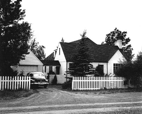
Warren Ranch House, c. 1945. (Courtesy Grant-Kohrs Ranch NHS) |
Once the Foundation had acquired Grant-Kohrs Ranch, Acting Regional Director Robert L. Giles informed Director Hartzog that ". . . we must move forward on the master plan." for the ranch. [4] Master plans, more recently termed general management plans, served as a basic planning framework for all national park units and were an essential step in the process of initially authorizing parks. Such documents varied somewhat from park to park, according to circumstances, and they could be updated periodically to address current needs and issues. Nevertheless, the first plan for any park was particularly important for outlining the basic resources, as well as management objectives. Most plans for small historic sites addressed concepts for preservation, visitor use, and land acquisition. These equated to estimated costs for lands, development, staffing, and operation.
A serious effort to prepare a master plan for the ranch had been launched early in 1971, prior to the acquisition of the site Although Montana Senator Lee Metcalf had been eager to introduce legislation to authorize the site as a unit of the System, the a bill could not be drafted until NPS was able to articulate in more detail its plans and needs for the area. Writing to Metcalf in January, NPS Assistant Director for Legislation Joe Holt informed the senator that some of the concepts for the area had changed with the acquisition of more lands than originally anticipated. The uses and benefits of the additional acreage would have to be evaluated with regard to the overall development concept for the site. [5]
A planning directive was prepared and approved by mid-March. The team, led by Landscape Architect John B. Sage from the Denver Service Center (DSC), included Yellowstone Park Superintendent Jack Anderson. Historian Edwin C. Bearss, and John Douglass, by then the assistant chief interpreter at Rocky Mountain National Park. The members rendezvoused at Deer Lodge early in May 1971. [6] The pressure was on to develop a master plan as quickly as possible to be ready for the Congressional hearings.
To no one's surprise, the team focused most of its attention on the proposed boundary for the site, addressing in particular a means of convenient public access. Deliberations began with the team's acceptance of the premise that the ranch house (HS-1) would be used as the primary visitor contact station. The most direct entrance to the Grant-Kohrs house led past Con Warren's residence, but in accordance with Con's request, this was designated as a service road only for park staff. He did, however, offer to donate an easement north of his house, passing in front of the big red barn, on which the Service could and later did construct an alternate access road. [7] The railroad, however, was opposed to a public crossing through their right-of-way at that point because of safety considerations.Therefore, an alternative entrance had to be found.
The area acquired by the Park Foundation included a small parcel of land, approximately 10 acres (designated as Tract E), lying between the Highway 10 and the railroad tracks, south of the Warren residence. Preliminary discussions between the NPS and Warren envisioned visitor parking and other facilities being located on this tract, but it, too, involved getting the public safely over the railroad tracks. [8]
The team, however, largely ignored this suggestion, preferring instead to bring visitors into the site from the south, through a small adjoining city park. This would be "a transitional zone where the existing diverse scenes can blend." Driving through the park along a tree-lined approach lane, the visitor would make a transition from the modern world to the days of the Kohrs and Bielenberg Ranch. A compelling consideration for the team's recommendation of this site as the park entrance stemmed from the inherent safety hazards associated with moving visitors across two sets of railroad tracks within the site. This location would route visitors from U. S. 10 (Main Street) west on Milwaukee Avenue and across the tracks outside the park boundary. The visitor entrance to Grant-Kohrs NHS, accordingly, would be via Park Street, which could be extended north from Milwaukee through the city park. Starting at the park boundary, a meandering low-key road would traverse the Stuart Meadow. A parking lot for 75 cars would be established on high ground, west of the tracks, a few hundred yards south of the historic buildings. The proposal also would "consolidate the relationship between city interests and historic ranch interests." Since the main park entrance would lie immediately west of downtown Deer Lodge, the potential benefit to the town "would be mutually beneficial." [9]
The planners considered a vehicular right-of-way to be the minimal NPS interest in the city park, labeled Parcel "S" on their map. "However," the team reported, "the potential to develop and protect this key area . . . is too important an issue to resolve without a cooperative approach to the question." City planners were interested in constructing a picnic area on joint-use acreage, though the team's comment suggests that the Park Service perceived a larger threat of commercial development at the front door of the historic site. [10]
|
|
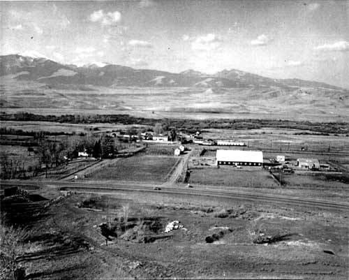
Aerial view of Grant-Kohrs Ranch, with
Warren Ranch in middle ground. (Courtesy Grant-Kohrs Ranch NHS) |
An initial draft of the master plan called for the visitor and support facilities to be on the west side of the still actively-used railroad tracks, so that staff would be readily available in the event of an emergency. Trains sometimes paused in this area for periods of up to half an hour. After reviewing the plan, however, Vein Hennesay wrote a note to Superintendent Anderson objecting to this element because, "without support facilities on the east side of the tracks, that small track [sic] of land is useless to us." [11] Subsequent versions of the plan placed park administrative buildings on Tract E, adjacent to Highway 10.
The master plan addressed several other important land considerations. Among these were the Deer Lodge sewerage lagoon north of the ranch, the two railroad rights-of way running through the property from north to south, bisecting the property; and three irrigation ditches. There were also utilities corridors across the lands. Although the Park Service expressed no intention of altering the use of these improvements, the team determined that action would be necessary to clarify and resolve the varied legal aspects relating to the interests. [12]
Beyond the land issues, this early plan outlined the initial management objectives that would serve as priorities for guiding the activities of interim and permanent staff over the next several years. It is worth noting that Grant-Kohrs Ranch NHS was intended initially to be a satellite area administered under Yellowstone National Park, and supervised on-site by a management assistant. [13] That the five-member team included Superintendent Anderson may have influenced this recommendation. However, until a congressional appropriation for the area was forthcoming, Assistant Superintendent Hennesay would continue to be key man for the new site.
Facilities at the site would be minimal and designed to be compatible with the historic setting of the ranch. The team proposed that park housing be constructed for some, but not all, of the staff for the sake of night-time security. Of course, public rest rooms and improved utilities connected with the City of Deer Lodge would have to be installed before the area could be opened to visitors.
The planners concluded by making general recommendations for additional studies, principally a historic structures report and an interpretive prospectus. Both would generate basic data essential to informed management of the resources, particularly the buildings in the defined historic zone encompassing the "old" ranch west of the railroads. Even though it might have been appropriate to include a historic resource study at the same time, the need for such a report was not identified until later. The team did, however, include the suggestion that living history be considered as an appropriate means of interpretation for the site. [14] The final master plan was issued early in 1973.
Key man Vein Hennesay met with regional office staff in Omaha on January 30, 1973 to discuss plans and short-term operations for the ranch. A crucial need was that of conducting a professional assessment of the structures so that a preservation plan could be developed. It was decided that a historical architect should be sent to the area as soon as possible to begin this process. Likewise, a staff curator should visit the ranch to inspect the collections with a view to improving environmental conditions and to train the resident seasonal ranger in cataloging techniques. [15] The condition of the Grant Kohrs house (HS-1), especially the roof, was a major concern on both counts.
The citizens of Deer Lodge, like most residents near newly-designated parks, found it difficult to understand the delays in bringing a unit to an operational level. The greatest impediment was, of course, the lack of funding. Until the beginning of fiscal year 1973, Yellowstone National Park had been bearing most of the costs for Grant-Kohrs. The NPS predicted that Congress would appropriate an operating program of $103,000.00, but the actual amount came to only $88,000. Still, it was a beginning. This modest budget at least would cover basic staffing and office equipment costs, along with the development of an alternative road by which Con Warren could access his ranch lands without going through the historic zone. [16]
The most sensitive planning issue at this early stage continued to be public access to the area. Hennesay and the others attending the January 1973 meeting agreed that it was not yet feasible to allow the public onto the ranch grounds, and that formal establishment should be delayed for an indefinite time. The question of where to put the park entrance "is the major thing holding us up," Hennesay later told the Silver State Post. "Once we get that decided we can proceed with other developments." [17] He predicted, prophetically as it turned out, that even though the staff was discouraging visitation, it would only be a matter of time until interested groups would pressure the NPS to open the ranch. Hennesay was able to evade the issue at the local level until September, when Chamber of Commerce Secretary Ted J. Mannix attempted to force a definitive answer by planning a celebration in conjunction with a grand opening. Hennesay was candid in admitting that the Service "was not in a position . . . to even guess when we might be able to have a dedication . . . ." [18]
Months passed, but Park Service officials could claim virtually no meaningful progress at the site. The temper of the local community, already on a short fuse, began to sizzle anew when it discovered that the NPS had not requested development funds for that year. The Service understood that planning had to precede any work on the ground, but it seems that no one had clarified this in the minds of Deer Lodge residents. On March 15, 1974 the local newspaper unleashed a front-page diatribe accusing the NPS of masking the facts "in bureaucratic confusion" resulting in the "unjustified and unnatural death" of Grant-Kohrs Ranch. [19] At a meeting the very next week, Chamber of Commerce members opened fire on Hennesay with a barrage of questions about the lack of activity, pointing especially to NPS failure to appoint a local manager who could devote full-attention to the site. One person in the audience offered the opinion that this was a principal reason things were in such disarray. The beleaguered key man agreed, but could only respond that his request had been "waiting in the personnel office in Washington since November." Hennesay unintentionally fueled the smoldering mood of the audience by predicting that no major allocation of money would be scheduled for the ranch until 1979. "This is a real sad thing," one audience member lamented, "We feel we have been shuffled aside and we won't be around long enough to see the project." At that point, Congressman Dick Shoup's representative, also present, waded into the fray declaring that, "We will bring pressures to bring this into fruition earlier." [20]
The Chamber and the Silver State Post were not the only ones concerned about the apparent lack of development at the historic site. Con Warren stirred his own political waves with the Montana delegation to find out what, if anything, the NPS was doing toward opening the ranch to the public. Responding to Warren's inquiry, Deputy Assistant Secretary of the Interior Douglas P. Wheeler expressed his regret that of the seventeen projects requested for Grant-Kohrs in fiscal year 1974 (beginning July 1, 1973), none had been funded. Included among these were the construction of an entrance road, water and sewer systems, restoration, and other facilities. The ranch, he confessed, had been upstaged by "commitments to Bicentennial projects" in celebration of the nation's 200th anniversary upcoming in 1976. [21] Warren probably found little comfort in Wheeler's comment informing him that the process of Service-wide priorities required two or three years to integrate new area projects into the funding program. [22]
Con remained unconvinced. Moreover, he was fuming over the NPS announcement of its preference for yet another proposed park entrance. According to this plan, Rainbow Avenue, running west from Main to a dead-end at the railroads, would be extended via an underpass beneath the tracks to connect with the park boundary. [23] Actually, this proposal had been a topic of discussion between NPS officials and the Deer Lodge City Council during the previous year. Vern Hennesay had expressed his view to the regional director that the Milwaukee entrance would route visitors "through one of the more undesirable parts of the city: namely the city utility yard." (This lay immediately north of the city park) Of even greater concern was the high potential for traffic to be blocked and backed-up for lengthy periods by train switching and refueling operations.
He pointed out that the railroad crossing on Milwaukee was the only route available to Deer Lodge's west side residents, thus the already high volume of traffic on this street. The Rainbow alternative would be somewhat shorter and would access the park directly on the east side, circumventing the Milwaukee Avenue problems, as well as the city park. [24]
The revised concepts of developing an approach road outside the park boundary rankled Con Warren. In recent years, Con had become somewhat distanced from the Deer Lodge community, probably as a result of his wife's chronic illness and his own change of lifestyle. [25] He resented the fact that the townspeople had not supported his six-year struggle to attract the government's attention to the historic ranch. These new plans, if adopted, would necessitate constructing a costly underpass, either on Rainbow Avenue or farther downtown on west-bound Milwaukee Avenue, to avoid traffic delays at the railroads. Warren saw this as being unnecessarily complicated with regard to opening the park. Venting his exasperation in a letter to Regional Director Lynn Thompson, heading the new Denver-based Rocky Mountain Region, Warren exclaimed, "The Powell County [Deer Lodge] Chamber of Commerce, the City Council, and the people of west Deer Lodge have long wanted an overpass of the railroads . . . They are using the Historic Site an excuse to get this overpass at the expense of the National Park Service." Firm in his denouncement, Con declared, "I do not intend to stand by and see these people use the Site for their own gain." [26]
Warren reminded NPS officials that their original understanding had been to install an access directly from Highway 10. Visitor facilities would be located east of the Burlington Northern tracks on Tract E, the parcel of land south of his house, ostensibly acquired by the Park Service for that purpose. Early concepts, in fact, envisioned a pedestrian underpass on a foot trail leading from a parking lot to the ranch proper. The Rainbow Avenue approach, he maintained, would permit unrestricted public access directly to the historic site and would infringe on his easement over the Stuart Meadow, west of the railroad. He particularly resented Congressman Shoup's demand that the Park Service "get this thing going, even if we can't go inside the building . . . [visitors can] peer in the windows . . . ." Warren demonstrated a keen grasp of park priorities by rejecting this as "ridiculous" because "it would only open the door for vandalism and pilferage, something we have been able to avoid so far." [27] He wanted the historic site developed, to be sure, but in an orderly, well-thought-out sequence. Warren, like most rural westerners, was accustomed to doing business on his word. If the NPS was not going to abide by its commitments to restore and preserve the ranch buildings first, and instead launch "into an ambitious and vastly expensive project such as the Rainbow Street overpass . . . [he] would not be interested in any further contributions...." [28] Con had drawn the line. It was high noon at the ranch.
He was not facing down the Park Service and Shoup alone, however. He had enlisted his friends, Montana Senators Mansfield and Metcalf, to back him up. Against these odds, Shoup quickly blinked, saying that he did "not mean for them to do a hurried job on the Ranch," only that the NPS should "start work on their planning and development phase ." [29] Predictably, the confrontation sparked a gust of letters throughout the halls of the Park Service, all of which were crafted to reassure Warren that preserving the integrity of the ranch was paramount. As further assurance to the ranch's benefactor, Rocky Mountain Regional Director Thompson arranged to come to the ranch to discuss the issues personally. [30]
Congressman Shoup used his influence to lever the chair of the House Appropriations Committee for Interior to advance the funding schedule for Grant-Kohrs Ranch. He announced in mid-July 1974 that the funding had been jumped up in priorities by one full year, at the same time criticizing the NPS for previously requesting planning money in the same year with development funds. Shoup secured promises of $30,000.00 for planning, plus an additional $100,000.00 for construction of the entrance road, parking lot, and a picnic area to be included in the 1974-75 appropriation. "I have been assured by the Park Service," said Shoup, "that they have no objection to this request and that if such moneys [sic] are appropriated in fiscal year 75 budget, this site would be available for public use in the summer of 1975." [31] At last, everyone seemed to be satisfied that the new park was on-track.
The serenity did not last long. But, it also became someone else's problem. Vern Hennesay, who had served as the coordinator for Grant-Kohrs for four and one-half years, was probably somewhat relieved to announce in July 1974 that a permanent manager had been selected for the site. During his seven years with NPS, Richard R. Peterson had followed a career path in administration from Rocky Mountain National Park, to Redwoods, to doing a stint as an urban trainee in Washington, D. C. He was serving as administrative officer for Mather Training Center at Harpers Ferry, West Virginia when he was tapped for the Grant-Kohrs Ranch job. His previous experience would serve him well in bringing to the site a sense of order and a thorough understanding of the NPS fiscal system. [32]
|
|
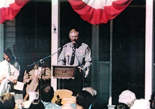
Superintendent Richard R. Peterson speaking
at park dedication, July 16, 1977. (Courtesy Grant-Kohrs Ranch NHS) |
Peterson was faced with myriad details in getting the fledgling park operation on a solid footing, challenge enough in itself, but the most pressing matter was the access issue. The community "was very anxious for something to happen," he would later recall in a 1996 interview. [33] This question had to be resolved, and with both public relations and those with Con Warren at stake, it had to be done diplomatically. Soon after his arrival, Peterson met with regional office staff in Denver, after which he had the unenviable duty of informing the press that, "the $130,000.00 did not include money for planing the access road," and "you can't build a road without planning." He added that the master plan would be re-done, with all of the proposed alternatives back on the table. Like his predecessor, Peterson still had no way of knowing when the park might open. Just what happened to the planning money Shoup had promised is uncertain, but it may have fallen victim to a mix-up in labeling during the appropriations process, and once branded, could not be reversed. Peterson assured everyone, however, that he and regional officials were working together to find the necessary funds. [34]
This news prompted a fresh campaign of letters to the Montana delegation, to which NPS Director Ronald H. Walker replied that the 1975 fiscal year Interior appropriation did in fact include $135,000.00 for Grant-Kohrs Ranch NHS. Part of this, he said, was earmarked for planning the entrance, while the lion's share would go to constructing the access and parking. He attempted to appease the citizens by expressing his confidence that the park still could be open to the public by summer 1975. [35] While Walker's announcement played well in the press, it is doubtful that his prediction was taken very seriously by anyone in the Denver Service Center.
In his first Superintendent's Report, Peterson acknowledged that much of his time during those first few months had been devoted to trying to "improve local relationships and work out ways to open the site." [36] He also was granted greater authority and latitude in leading the park effort when the area was declared an independent park, thus severing it from oversight by Yellowstone, effective December 8, 1974.3 [37]
|
Superintendent Peterson got things moving by working with regional and service center staff to prepare an environmental assessment to evaluate the various proposals and their potential impacts on resources. Included was a presentation of the three alternatives for developing the public entrance to the site. Peterson scheduled a public meeting at the court house in Deer Lodge for March 26, 1975, to afford local residents an opportunity to express their views. When it came time to discuss the now touchy issue of where to construct the park entrance, members of the Deer Lodge Chamber of Commerce quickly proved the truth of Con Warren's suspicions. Spokesman Ben Bailey readily concurred that the plan "providing for a walkway underpass at the railroad tracks is the most economical and much the fastest to accomplish." But, he went on to explain the town's need for the vehicular underpass preferably on Milwaukee Avenue, or father north on Rainbow Avenue, largely ignoring the real issue at hand -- the park's requirements. Revealing the true motive, Bailey concluded by offering the opinion "that the Rainbow underpass is the most practical," adding that it was the Chamber's intention "to make every effort to bring this about to the benefit of all in our community." A second Chamber member echoed this opinion, saying that, "The overpass at the Milwaukee is the one we'd all like to have. [38]
Two other individuals then spoke up, revealing that the Chamber did not necessarily speak for the entire community. One person representing the Friends of the Earth, an environmental group, offered the candid opinion that the town's need for such an overpass had existed long before the arrival of the National Park Service and that the agency should not be in the business of building roads for municipalities. "I personally don't think the Park Service should have to pay for the road," echoed another westside resident. ".... the town has had a need for the access for a long time and if the town hasn't come up with it yet it is not the Park Service's fault." [39]
Peterson proceeded to make a determination shortly thereafter. On April 28 he notified Regional Director Lynn Thompson that despite the urgings of the Chamber of Commerce, "We must select alternative D.3" [the Highway 10 access]. He based his decision on several practical reasons. First among these was the exceedingly remote chance that the Service could obtain, much less justify, the estimated $2 million for the town underpass. Additionally, the highway entrance would be easier for visitors to find, and it would have the least impact on both the ranch and its ecological integrity. As Peterson put it, this was "the only feasible route if we are to have any chance of opening this season." [40]
On May 15, 1975 the Park Service announced its choice to the public, softening the town's disappointment with the assurance that every effort would be made to open the ranch by late in the summer. The new entrance would include a visitor contact station and a parking lot east of the tracks, and a quarter-mile pathway to the ranch complex, via a pedestrian underpass. [41] Much remained to be done, though. Further planning and design, archeological assessments, and other park development needs to provide for public visitation, would in fact delay the opening of the site for two more years. (Those aspects are addressed in later chapters.)
Superintendent Peterson appreciated the delicate position the Service was in and knew that visible progress had to be demonstrated at the park. The community was restless and growing ever more pessimistic over the seemingly endless delays with getting the park on an operational footing. Nevertheless, Peterson used the media and local club meetings to skillfully articulate the Service's dual mandate for "making areas available to the public for its use and at the same time preserving the sites for the future." [42] In the weeks following the public meeting, he demonstrated good faith by following through on commitments to coordinate with the Denver Service Center (DSC) to prepare plans and specifications for a parking lot. Working along parallel lines, the Rocky Mountain Regional Office backed him with procurement support in letting a contract for the construction of the entrance. [43]
Back at Deer Lodge, Peterson and DSC Historical Architect Peter Snell located and purchased two old ranch buildings that would have to suffice for a visitor contact station and rest room facility until permanent buildings could be funded. All of these facilities, in fact, were considered to be temporary, since further planning would be necessary to determine long-term staffing and visitor needs for the park. [44]
|
|
Visitor contact station (left) and restrooms
(right) during construction. (Courtesy Grant-Kohrs Ranch NHS) |
Temporary or not, it was progress. Peterson's common sense strategy of relating well with the community and doing his best with what little he had effectively stifled the public criticism of the Service. Through his efforts, the townspeople came to better appreciate the enormous challenges the park faced and became much more understanding of the NPS position. "It's been a typical year in the life of a new and growing Park Service area," Peterson reported at the end of 1975. "We have been short of everything and at times things looked impossible . . . We will get into operation soon and will start to reap some of the rewards of Park Service work to accompany the sweat and frustrations [of] getting there." [45]
With the selection of an entrance site on Tract E, opposite the Powell County Fair Grounds, Superintendent Peterson faced an urgent need to re-evaluate the initial development concepts for the ranch. An access on the southern boundary of the site between the railroad and Clark Fork, as originally envisioned, called for visitor parking on the west side of the railroad right-of-way. Now, placing the main gate on the east side of the park demanded a means of getting visitors safely across two parallel sets of railroad tracks. A pedestrian underpass already seemed a foregone conclusion, yet this was contingent upon permission being granted by both the Milwaukee and Burlington Northern railroads. Peterson's skills as a negotiator would be put to the test in surmounting this hurdle, one that would further postpone public visitation to the site.
A second planning team assembled at Deer Lodge in May, 1976. Team leader Jim Massey, on the DSC staff, wanted to meet at the site to allow close concert with the park staff, which by this time Peterson had succeeded in expanding to include interpretation, maintenance, and administration components. This new planning effort would be founded on more realistic conditions now that the park was actually gearing up.
Likewise, the new General Management Plan (GMP) format adopted by the NPS took a comprehensive approach intended to "provide the . . . very best management action document which will serve the short and long range needs of the park, while guiding preservation and use." [46] To do this, Massey put together an interdisciplinary group including the park staff, as well as DSC Research Historian John Albright, and Nan Rickey, a DSC specialist in historic furnishings and curatorial management.
This new team re-shaped the interpretive premise upon which planning would rest. Whereas the first master plan had defined the objective in terms of recreating "the historic mood and way of life . . . of this early cattle ranch," and gave only a nod to the story of the cattle industry, the 1976 team placed great emphasis on providing the visitor with "an understanding of the evolution of American cattle ranching, from open range to early farm-ranch cattle raising . . . ." This change in direction undoubtedly stemmed from the team's composition, a group heavily weighted with trained historians. The new plan also would be based on a decision not to restore the site to historic times, because the era of active operations extended from the mid-nineteenth to the mid-twentieth centuries. It was thought that the various types of buildings and architectural styles would benefit the interpretation of evolving cattle operations. The team did, however, recognize that the open range era could not be adequately addressed at the site because the home ranch was only the headquarters of an operation that extended over a vast area of Montana and Idaho. Therefore, that part of the story would be dealt with through audio visual presentations and exhibits. [47]
Although the first master plan had generally outlined classifications for land use within the boundaries of the site, the GMP team subdivided the area into "management zones" dedicated to specified uses. This was intended "to guide future management, use, and development of the park's lands and resources" to avoid conflicts and degradation of the inherent nature of the area. The core zone, of course, was the area immediately surrounding the historic home ranch buildings west of the railroads. A sizable buffer around this encompassed the hay meadows to the north and west. The all-important visitor use sub-zone was delineated in the southeast corner of the property. Significantly, the city park parcel that had so influenced the access issue, was deemed to be of no further use to the park and it was recommended that this 26-acre parcel be excluded by a boundary adjustment. [48]
The plan recognized the temporary nature of the existing contact station moved in by the park staff. It was recommended that these old buildings be replaced as soon as possible by a modest-sized new structure designed for the purpose that would be compatible with the historic ranch buildings. The permanent facility was to be located "near the site of the present temporary facility and parking area." [49] To reduce the visual impacts by development near the park entrance, the team recommended that consideration be given to adaptively restoring the "red barn" still in use by Con Warren. If and when his holdings could be acquired, the barn would provide ample space for the park administrative headquarters and maintenance operations. [50]
The plan also emphasized the continued use of the historic structures. Wherever possible those uses should reflect "the buildings' last useful function" in the ranching operation. This would in turn dictate the period to which individual buildings were to be restored or preserved "in a working condition." The team identified bunkhouse row (HS 2), the thoroughbred barn (HS-15), and the ice house (HS-5) as the major structures to be restored to their 1930s appearances, while the ranch house itself (HS-1) would reflect the zenith of its architectural development and importance as the ranch headquarters during the 1900 - 1920s period. It was also stressed that the grounds around the buildings in the historic zone should not be kept too clean, and therefore out of character with a working ranch. [51]
The need for a suitable curatorial facility where objects could be treated and, if necessary, stored in environmentally stable conditions was an early consideration advanced in this GMP. There was no preferred location expressed in the plan, though it was implied that it would lie within the park boundary. The team was wise enough to recommend that the issue be addressed by professionals in the museum field. [52]
The team concluded its work by recommending that several studies be undertaken to generate basic data useful in guiding future management of Grant-Kohrs. Perhaps the highest priority was for a compilation of historical research data, which resulted in a comprehensive historic resource study authored by John Albright. By the time the study was completed, it had been expanded to include the Kohrs-Bielenberg biographical information and the architectural data research identified by the planning team. Also suggested were a study to evaluate the historic landscape and a ranching operations plan.
As it happened, "Pete" Peterson did not remain at Grant-Kohrs Ranch long enough to see the completion of the plan he had initiated. His steady-hand at the helm of the ranch during trying times had been noticed at higher levels in the NPS. A proven administrator, Peterson was selected for the Departmental Manager Trainee Program and three years, almost to the day, after his arrival Peterson left for a new assignment in Washington, D. C. He did, however, have the pleasure of hosting the official opening of Grant-Kohrs Ranch National Historic Site just prior to his departure.
Despite the compressed schedule outlined for developing the GMP, team leader Massey also left his position, accepting a transfer to another agency shortly after the site visit. A draft was completed in December 1976, but afterwards the plan languished for lack of attention. It was some time before Massey's successor, Benjamin Brandt, took up the reins of the project and became familiar enough with the details to lead the effort to completion. [53] Meantime, a change in superintendents at the park probably contributed to the loss of momentum as well. Consequently, the final GMP was not approved until February 1980.
Thomas G. Vaughan followed Peterson into the superintendency at Grant-Kohrs Ranch NHS, arriving in the latter part of October 1977. Vaughan came from a more traditional ranger background than had his predecessor. A graduate student in anthropology, he had served as a seasonal archeologist-interpreter at Mesa Verde National Park in 1966. He subsequently worked for a private museum in Hawaii before eventually returning for another stint at Mesa Verde. After almost giving up on the possibility of a permanent NPS career, Vaughan was eventually selected as a ranger intake and, after attending basic training, was assigned to City of Refuge National Historical Park, back in Hawaii. He later moved to Haleakala as a district ranger and later still to Point Reyes as assistant chief naturalist. His introduction to park management came with a hitch as superintendent at Hubbell Trading Post NHS on the Navajo Reservation in Arizona. After spending three enjoyable years there, Vaughan applied for the superintendency at Grant-Kohrs and was selected to fill the job. [54]
One of his first challenges was to pick up the reins of the planning effort. Although the approved version of the plan differed little from the draft, it nevertheless reflected Vaughan's varied background, especially with agricultural landscape concerns not unlike those he had encountered at Hubbell. An important aspect common to both was the recommendation that additional lands within the designated boundary be acquired in fee ownership by the NPS. There were two reasons for this. One of the mandates for the area was that it be operated as a working ranch. It became all too apparent that the acreage (216.79) owned by the Service simply was too small for any sort of meaningful stock raising program for public education. In addition, many undesirable uses of the easement lands still held by Warren could not be adequately controlled, despite the covenants provided in the agreements. These were strong motivations for management to work toward purchasing the additional acreage. [55]
| <<< Previous | <<< Contents >>> | Next >>> |
grko/adhi/chap2.htm
Last Updated: 28-Aug-2006