|
Great Sand Dunes National Park and Preserve Colorado |
|
 NPS photo | |
Stone, Sand, and Stream
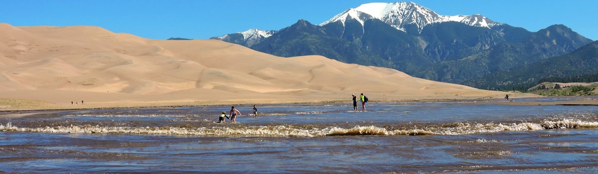
Nestled against the rugged Sangre de Cristo Mountains, the Great Sand Dunes are the focal point of a wild natural system of high mountain peaks, sparkling streams, forceful winds, and billions of sand grains. Here majestic scenery also gives intimate glimpses of life's rich complexity.
These huge dunes—North America's tallest—are about 11 percent of a 330-square-mile deposit of sand. Eroded from mountains, then shattered by freezing and thawing, and tumbled by streams and winds, sand grains cycle through the dunes system. Plants stabilize most sand deposits outside the dunefield, where old dunes, now grass- and shrub-covered, are difficult to recognize.
Medano and Sand creeks edge the dunefield as the dunes system's lifeblood. Swift, shallow, and seasonal, they recycle sand as they water this arid valley. Habitats alongside them host a great deal of life's richness here, its biodiversity. The streams originate in the Sangre de Cristos of Great Sand Dunes National Preserve. High, cold mountains collect and hold snow from October into April, releasing it in icy streams in late-spring warmth. As community builders, the creeks feed the underground aquifers for San Luis Valley residents' wells, local agriculture, and livestock. People have lived here for 11,000 years. In historic times Southern Ute, Jicarilla Apache, Navajo, gold miners, homesteaders, ranchers, and farmers have lived here, and migrant workers labored here. By the 1920s the dunes fed local pride and tourist income, and valley residents pressed for the national monument status under the Antiquities Act finally realized in 1932. The area's expansion in 2000 as a national park and national preserve was driven both by better knowledge of water's many and complex roles here and the American people's desire to protect the dunes system—dunes, mountains, creeks, and wetlands—forever.
The wealth of habitats making life so rich here will enrich your experience. Look beyond the dunes for further adventures among creeks, forests, grasslands, foothills, mountains, and wilderness.
Seven Life Zones of Great Sand Dunes
Life zones are determined by elevation, latitude, climate, and exposure to sunlight. The range of elevations at Great Sand Dunes National Park and Preserve offers you many life zones to explore.
Stone
ALPINE TUNDRA
Treeless alpine tundra occurs above 11,000 feet (3,350 meters), where
winds blast rugged peaks ice-covered up to 10 months per year. Despite
short growing seasons, small plants thrive by growing close to the
ground and between rocks for wind protection. Animal life includes the
American pika, yellow-bellied marmot, and Rocky Mountain bighorn sheep.
In summer, watch for hawks, golden eagles, horned larks, and
white-tailed ptarmigan A warming climate threatens the habitat of pikas,
marmots, and ptarmigan.
SUBALPINE
Subalpine forest (9,500 to 11,500 feet; 2,900 to 3,500 meters) gets
heavy snowfall, making it cold and damp all year. Hardy, stout trees,
including Englemann and blue spruce, withstand heavy snow without
breaking, while flexible subalpine firs bend to shed the snow's weight.
Broad sunny meadows are wet and vibrant with summer wildflowers and
mosquitoes. Watch for mule deer, elk, beaver, black bears, and northern
harriers, gray jays, and Steller's jays.
MONTANE FOREST
Montane forests and piñon-juniper woodlands occupy like elevations
(8,000 to 9,500 feet; 2,440 to 2,900 meters) but prefer different
habitats. Montane species (Douglas fir, aspen, and narrow-leaf
cottonwoods) thrive in wet drainages. Piñon pines and junipers prefer
sunny hillsides. The contrasting habitats and plants attract a wide
variety of wildlife. Black bears forage for insects, berries, and
rodents; bobcats range hillsides in search of rabbits, Abert's
squirrels, and other small animals; pine siskins and juncos feed among
the trees. Short wings and long, rudderlike tails allow the northern
goshawk to fly through dense forest without colliding with branches.
Sand
DUNEFIELD
At a distance dunes look barren, but up close you see how life adapts to
fill every niche. Seven insect species thrive here and nowhere else in
the world, but only one mammal, Ord's kangaroo rat, lives in the
dunefield, although coyotes, mountain lions, and elk wander through
parts of it. Indian rice grass, blowout grass, and scurfpea, common in
sandy dry areas, grow in the swales between dunes, anchored by their
root systems. Here they survive the grit of windblown sands and the high
surface temperatures.
SAND SHEET & GRASSLAND
The vast sand sheet around the dunes makes up about 53 percent of the
sand deposit. Grasses and shrubs, like rabbitbrush, prickly pear, and
yucca, grow over old dunes, stabilizing them with their roots and
reducing wind speeds with their branches and leaves. Many animals
frequent the grasslands and sand sheet—elk, mule deer, pronghorn,
white-tailed jack rabbits, and coyotes. Iridescent caterpillars that
cling to rabbitbrush shrubs in the spring transform into green-striped
rabbitbrush beetles in summer.
SALT-ENCRUSTED PLAIN OR SABKHA
Low-lying salt-encrusted plains, or sabkha, make up 36 percent of the
sand deposit west and south of the dunefield. Wetlands and patches of
white, crusty sand dot this area. Alkaline minerals leached from the
high water table cement the surface as a fragile crust. Few plants, like
saltbush and saltgrass, tolerate this harsh area, although slightly
higher and less alkaline areas nearby may host plants and animals of the
sand sheet. Wetlands in the sabkha attract migratory birds, like the
sandhill crane and American white pelican.
Stream
Exploring the Park from Streams to Summits
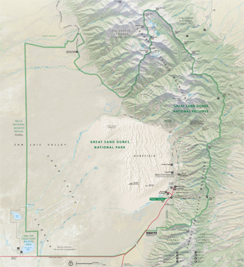 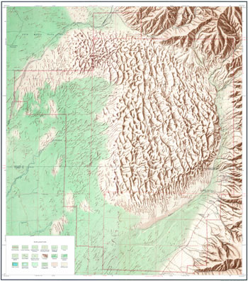 (click for larger maps) |
STREAM SIDES & WETLANDS
Medano and Sand creeks flow seasonally around the dunefield. They carve
sand from its eastern, western, and northern edges and redeposit it to
the south, where wind will recycle it back into the dunefield.
Vegetation alongside creeks creates oases in which cottonwoods, willows,
golden currants, and Wood's roses thrive. Watch for the red and yellow
flash of western tanagers and the bold, black-and-white of magpies.
Subsurface flow from these streams feeds the wetlands that foster amazing life in the midst of a sandy desert.
Origins of the Dunes
Wind and water move sand, continually forming dunes. Most sand comes from the San Juan Mountains, over 65 miles to the west. Larger, rougher grains and pebbles come from the Sangre de Cristo Mountains. Sand and sediments from both ranges washed into a huge lake once covering the valley floor. As the lake reduced, prevailing southwesterly winds bounced the sand grains to be piled up beneath the Sangre de Cristos or washed back toward the valley floor. Northeasterly storm winds blast through mountain passes, piling dunes back on themselves and creating North America's tallest dunes. The dunes are probably less than 440,000 years old.
More than Sand Dunes The park is open 24 hours a day, year-round. Visitor center hours vary by season.
You can explore the mountains, diverse forests, and grasslands here as well as sand dunes. Each season offers different experiences. Pick up a visitor guide, stop by the visitor center, or check the park website to learn more about the wide variety of programs and recreational opportunities.
Accessibility We strive to make our facilities, programs, and services accessible to all. For information go to a visitor center, ask a ranger, call, or check our website.
Safety Don't rely on computer road mapping here. The only paved-highway access is via US 160 and CO 150 from the south, or CO 17 and County Lane 6 from the west. • Lightning strikes can be fatal. If you see a thunderstorm, get off the dunes! Storms and cold weather can occur any time of the year. • Summer sand surfaces reach 140°F. Hike dunes in early mornings or evenings then. Wear closed-toe shoes and monitor pets' feet. • Elevations range from 7,500 to nearly 14,000 feet. Seek medical advice about doing vigorous exercise. Elevation sickness symptoms are short breath, headache, and nausea. Drink lots of water.
Do not feed any wildlife. It is dangerous for you and unhealthy for them.
Wilderness at Great Sand Dunes
Congress has protected nearly 90 percent of Great Sand Dunes National Park and National Preserve as wilderness under the 1964 Wilderness Act. The Great Sand Dunes Wilderness is 33,549 acres in the national park, and 41,676 acres of the national preserve are in the Sangre de Cristo Wilderness.
Wilderness designation protects forever the land's wilderness character, natural conditions, opportunities for solitude, and scientific, educational, and historical values. In wilderness people can sense being part of the whole community of life on Earth.
Source: NPS Brochure (2019)
|
Establishment
Great Sand Dunes National Park and Preserve — September 24, 2004 (designated) |
For More Information Please Visit The  OFFICIAL NPS WEBSITE |
Documents
2007 Rocky Mountain Section Friends of the Pleistocene Field Trip — Quaternary Geology of the San Luis Basin of Colorado and New Mexico, September 7-9, 2007 (Michael N. Machette, Mary-Margaret Coates and Margo L. Johnson, 2007)
A History of Great Sand Dunes National Park and Preserve: Timeline (DOI, 2004)
Acoustic Monitoring 2009, Great Sand Dunes National Park and Preserve NPS Natural Resource Report NPS/NRSS/NRTR-2014/834 Jessica Briggs, January 2014)
Acoustic Monitoring Report, Great Sand Dunes National Park and Preserve NPS Natural Resource Report NPS/NRPC/NRTR-2008/001 (Emma Lynch, October 2008)
Alpine Vegetation and Soils Monitoring in Great Sand Dunes National Park and Preserve: 2010–2015 Data Report NPS Natural Resource Data Series NPS/ROMN/NRDS—2019/1229 (Claire Tortorelli, Bernadette Kuhn, Erin Borgman, Joe Stevens, Tom Baldvins and Mike Britten, July 2019)
Alpine vegetation composition, structure, and soils monitoring for Great Sand Dunes National Park and Preserve: 2009 Summary Report NPS Natural Resource Data Series NPS/ROMN/NRDS—2010/056 (Isabel Ashton, Mike Britten, Donna Shorrock and Billy Schweiger, June 2010)
Alpine vegetation composition, structure, and soils monitoring for Great Sand Dunes National Park and Preserve: 2010 Summary Report NPS Natural Resource Data Series NPS/ROMN/NRDS—2011/152 (Isabel W. Ashton, March 2011)
Alpine Vegetation Composition Structure and Soils Monitoring Protocol: 2010 version NPS Natural Resource Report NPS/ROMN/NRR—2010/277 (Isabel Ashton, E. William Schweiger, Jennifer Burke, Donna Shorrock, Davd Pillmore and Mike Britten, December 2010)
Clean Water Act: Water quality designated uses and impairments for Great Sand Dunes National Monument and Preserve NPS Technical Report NPS/NRWRD/NRTR-2003/308 (March 2003)
Climate and Species Traits Shape Responses of Alpine Flora in the US Rocky Mountains to a Changing World: Analysis of Five GLORIA Sties across the Southern Rockies NPS Science Report NPS/SR-2024/221 (Claire Powers, Erin Borgman and Daniel F. Doak, December 2024)
Comprehensive Interpretive Plan, Great Sand Dunes National Monument (Final Draft, August 2000)
Development of a Grazing Monitoring Program for Great Sand Dunes National Park, Colorado USGS Open-File Report 2015-1136 (Linda C. Zeigenfuss and Kathryn A. Schoenecker, 2015)
Elk and bison grazing ecology and management in Great Sand Dunes National Park and Preserve (Francis J. Singer and Kathryn A. Schoenecker, July 25, 2004)
Forest Health of High-Elevation, Five-Needle Pines at Glacier National Park, Rocky Mountain National Park, and Great Sand Dunes National Park and Preserve: 2013 Data Report NPS Natural Resource Data Series NPS/ROMN/NRDS-2017/1112 (Erin Borgman, August 2017)
Foundation Document, Great Sand Dunes National Park and Preserve, Colorado (January 2017)
Foundation Document Overview, Great Sand Dunes National Park and Preserve, Colorado (January 2017)
Future Water Use Assessment, Great Sand Dunes National Park and Preserve NPS Natural Resource Report NPS/NRSS/WRD/NRR-2017/1412 (Gwen Gerber, March 2017)
General Geology of the Northern San Luis Valley, Colorado (James P. McCalpin, undated)
Geologic map of Great Sand Dunes National Park, Colorado USGS Scientific Investigations Map 3362 (Richard F. Madole, D. Paco VanSistine and Joseph H. Romig, 2016)
Geologic Map of Parts of Great Sand Dunes National Park and Preserve, Colorado (February 2006)
Geologic Map of Parts of Great Sand Dunes National Park and Preserve, Colorado (May 2019)
Geologic Resource Evaluation Report, Great Sand Dunes National Park & Preserve NPS Natural Resource Report NPS/NRPC/GRD/NRR-2006/011 (March 2006)
Geology Along Mosca Pass Trail, Great Sand Dunes National Park and Preserve, Colorado: A Trail Guide and Introduction to the Geology of the Sangre de Cristo Range East of Great Sand Dunes USGS Circular 1374 (David A. Lindsey, Terry L. Klein, Andrew Valdez and Robert J. Webster, 2012)
Great Sand Dunes National Monument (The San Luis Valley Historian, Vol. XIV No. 2, Spring 1982, ©The San Luis Valley Historical Society, all rights reserved)
Great Sand Dunes National Monument: An Administrative History (C. Joe Carter)
The Tragic Legend of Mosca Pass (Shirley R. Carter)
A Legend of the Sand Dunes (Luther E. Bean)
Climatic Change in the San Luis Valley (John A. Mangimeli)
The Disappearing Sheep of the Sand Dunes (M.D.M., Alamosa Journal, August 6, 1885)
San Luis Sand Dunes (Millie Holbrook Velhagen)
The Singing Sands of Alamosa (Kim Gannon and Bert Reisfeld)
Song of the Sand Dunes (Ray Madison)
Great Sand Dunes National Monument (The San Luis Valley Historian, Vol. XXII No. 3, 1990, ©The San Luis Valley Historical Society, all rights reserved)
Natural History of the Great Sand Dunes (Libbie Landreth)
Cultural History of the Great Sand Dunes (C. Joe Carter)
A Legend of the Sand Dunes (Luther Bean)
Climatic Change in the San Luis Valley (John A. Mangimelli)
Culturally Peeled Ponderosa Pine Trees (Marilyn A. Martorano)
Archaeological Research in the San Luis Valley (Dennis Stanford)
Greater Sand Dunes Interagency Fire Management Plan Environmental Assessment/Assessment of Effect (April 25, 2005)
Great Sand Dunes National Park and Preserve Wetland Ecological Integrity: 2010–2014 Status and Trend Report NPS Natural Resource Report NPS/ROMN/NRR—2017/1569 (E. William Schweiger, Mike Britten and Jennifer Jones, December 2017)
Ground-Water Age and Flow at Great Sand Dunes National Monument, South-Central Colorado USGS Fact Sheet 2004-3051 (Michael G. Rupert and L. Niel Plummer, July 2004)
Ground-Water Flow Direction, Water Quality, Recharge Sources, and Age, Great Sand Dunes National Monument, South-Central Colorado, 2000-2001 USGS Scientific Investigations Report 2004-5027 (Michael G. Rupert and L. Niel Plummer, 2004)
Hydrogeology of the San Luis Valley, Colorado: An Overview — And a Look at the Future (Philip A. Emery, undated)
Hydrology of the San Luis Valley, South-Central Colorado USGS Open-File Report (P.A. Emery, A.J. Boettcher, R.J. Snipes and H.J. McIntyre, Jr., June 1969)
Junior Rangers and Park Explorers, Great Sand Dunes National Park and Preserve (2014; for reference purposes only)
Land of Contrast: A History of Southeast Colorado (PDF edition) BLM Cultural Resources Series No. 17, Colorado State Office (Frederic J. Athearn, 1985)
National Register of Historic Places Nomination Forms
Indian Grove (Marilyn Martorano, April 9, 1999)
Medano Ranch Headquarters (R. Laurie Simmons and Thomas H. Simmons, August 29, 2003)
Pike's Stockade (Joseph Scott Mendinghall, December 1, 1975)
Superintendent's Residence (Steven F. Mehls and Carol D. Mehls, July 1, 1989)
Trujillo Homestead (R. Laurie Simmons and Thomas H. Simmons, August 29, 2003)
Zapata Ranch Headquarters (Judith Broeker, October 22, 1992)
Native American Prayer Trees of Colorado (John Wesley Anderson, extract from The Denver Westerners Roundup, Vol. 76 No. 5, September-October 2020; ©Denver Posse of Westerners, all rights reserved)
Natural Resource Condition Assessment, Great Sand Dunes National Park and Preserve NPS Natural Resource Report NPS/ROMN/NRR-2017/1402 (Karin Decker, Michell Fink and Mike Britten, March 2017)
On the origin and age of the Great Sand Dunes, Colorado (Richard F. Madole, Joe H. Romig, John N. Aleinikoff, D. Paco VanSistine and Ezra Y. Yacob, extract from Geomorphology, Vol. 99, 2008)
Park Newspaper: 2005 • 2006 • 2007 • 2009 • 2010 • 2011 • 2014 • 2016 • 2017 • 2018 • 2019 • 2022
Quaternary Geology of Great Sand Dunes National Park and Preserve, Southern Colorado USGS Open-File Report 2007-1193 (Andrew Valdez, Steve Forman, Richard Madole, James McCalpin, Michael Machette, Randy Schumann, Mike Rupert, Shannon Mahan and Fred Bunch, extract from 2007 Rocky Mountain Section Friends of the Pleistocene Field Trip—Quaternary Geology of the San Luis Basin of Colorado and New Meico, September 7-9, 2007, 2007)
Resource Brief: Effects of Human Disturbance and Ungulate Use on Wetland Ecological Integrity at Great Sand Dunes National Park and Preserve (July 23, 2018)
Resource Management Plan, Great Sand Dunes National Monument (1992)
Rocky Mountain Network News and Highlights, Grand Sand Dunes National Park and Preserve (Spring 2008)
San Luis Valley Project, Closed Basin Division, Colorado (undated)
Seepage Investigation of Deadman Creek, Sand Creek, Big Spring Creek, and Little Spring Creek: September 22, 23, AND 24, 2004, Great Sand Dunes National Park and Preserve, Colorado NPS Natural Resource Report NPS/NRPC/WRD/NRTR-2007/071 (James J. Harte, Andrew D. Valdez and Sharla A. Stevenson, December 2007)
Shaded Relief Map: Great Sand Dunes National Monument, CO Scale: 1:24,000 (USGS, 1985)
Statement for Management — Great Sand Dunes National Monument (February 1988)
Surficial Geologic Map of Great Sand Dunes National Park and Preserve, Colorado (2019)
Tertiary Stratigraphy and Tectonic Development of the Alamosa Basin (Northern San Luis Basin, Rio Grande Rift, South-Central Colorado Geological Society of America Special Paper 291 (Brian S. Brister and Robbie R. Gries, 1994)
The Geologic Story of Colorado's Sangre de Cristo Range USGS Circular 1349 (David A. Lindsey, 2010)
The Role of Streams in the Development of the Great Sand Dunes and Their Connection with the Hydrologic Cycle (Andrew D. Valdez, undated)
The Great Sand Dunes of Southern Colorado USGS Professional Paper 575-C (Ross B. Johnson, extract from Geological Survey Research 1967: Chapter C, 1967)
The Road Inventory for Great Sand Dunes National Monument (Colorado) (Federal Highway Administration, June 1998)
The Status of Dwarfed Populations of Short-Horned Lizards (Phrynosoma hernandesi) and Great Plains Toas (Anaxyrus cognatus) in the San Luis Valley, Colorado (©Megan E. Lahti, Doctor's Thesis Utah State University, 2010)
Ungulate Management Plan and Environmental Impact Statement, Draft, Great Sand Dunes National Park and Preserve (April 2018)
Ungulate Use and Wetland Condition in the Ungulate Management Plan Baseline Period (2016–2019): reat Sand Dunes National Park and Preserve NPS Science Report NPS/SR-2025/258 (E. William Schweiger, Linda Zeigenfuss, Dewane Mosher, Kirk Sherrill and Dana Witwicki, March 2025)
Vegetation Classification and Mapping Project Report, Great Sand Dunes National Park and Preserve NPS Natural Resource Report NPS/ROMN/NRR—2011/341 (David Salas, Joe Stevens, Keith Schulz, Mike Artmann, Beverly Freisen, Steve Blauer, E. William Schweiger and Andrew D. Valdez, March 2011)
Visitor Study: Summer 2002, Great Sand Dunes National Park and Preserve (Yen Le and Margaret Littlejohn, February 2003)
Wetland Habitat Use by Elk and Bison in Great Sand Dunes National Park (Linda C. Zeigenfuss, E. William Schweiger and Kirk Sherrill, 2024)
grsa/index.htm
Last Updated: 22-Mar-2025