|
Indiana Dunes National Park Indiana |
|
 NPS photo | |
A WEALTH OF HABITATS OFFER YOU HIKING, BIKING, BIRDING, WILDFLOWERS, AND WATER RECREATION
LAKE Indiana Dunes National Lakeshore is a National Park Service area. It has 15 miles of beach along Lake Michigan's southern shore between Gary and Michigan City in Indiana. Michigan is third largest of the five Great Lakes, whose origin lies in many episodes of glaciation by ice sheets up to 2.5 miles thick during 1.6 million years or more.
Water and beaches offer far more things to do than we can describe here. You could even travel the 35-mile Lake Michigan Water Trail and camp at the designated sites as you progress.
BEACH A beach is a transition between lake and land. Lapped by lake water, the lower beach hosts no plants big enough to see, but scavengers, from tiny carrion flies to gulls and shorebirds, feed on remains of fish, birds, and insects that wash ashore. Raccoons and skunks join in the feeding at night after bathers and sun worshippers have retired farther inland.
Plants, like sea rocket, bugseed, cocklebur, pigweed, and seaside spurge, do take hold higher up the beach, where only summer storms hit. These plants may begin the formation of a dune.
DUNES Marram grass on the upper beach is the real dune stabilizer. Safe from the elements, except for the heavy winter storms, the marram grass along with cottonwood seedlings and sand reed grass anchor the sand. It is easy to underestimate the key role these plants play in building the dunes and shaping the landscape around you.
Marram grass puts out seeds, but dual-purpose underground stems, or rhizomes, explain its tenacity. Rhizomes spread networks of new roots across dunes, further anchoring mounds of windblown sand captured by the grass blades.
PONDS BETWEEN DUNES When winds blow out a dune, a bowl can form and later be protected from wind. Then, organic matter from dead plants and animals can build up, enabling trees to grow.
If the bowl reaches down to the water table, a shallow pond may form and harbor wood ducks. Pond shorelines shrink in dry weather to form many smaller pools where toads lay vast masses of eggs in early spring. These interdunal pond habitats magnify the diversity of life in the dune environment.
MARSH Marshes form in many ways, from shallow backwaters of creeks or rivers, from former lakes or ponds, or from shallow lagoons created when a lake level drops quickly. Cattails and grasses advance toward the center of the marsh while water lilies, arrowhead, and spatterdock cover the open water. Red-winged blackbirds nestle in the reeds.
Marshes in the park host a rich mix of life, with more species and greater numbers than found in most habitats.
OAK SAVANNA Oak savannas look like prairies dotted with trees—black or white oak—and shrubs like chokecherry, shadbush, witch hazel, and sumac. Midsummer flowers include the lupine, birdsfoot violet, aster, and blazing star. Dense forests that cover older dunes host spring-blooming flowers before tree leaves block the sunlight.
Trees take over a marsh that's filling in, forming a swamp forest of red maple, yellow birch, sourgum, and pin oak. Trees can take over older dunes so much that they become known as hardwood dunes, with oak, hickory, and white ash.
PRAIRIE The national lakeshore, at the upper- and eastern-most limits of tallgrass prairie habitat, features quality remnants of this ever-diminishing mixture of plants that once covered 140 million acres of North America. Tallgrass means tall: big bluestem, little bluestem, indiangrass, and switchgrass can grow to eight or nine feet tall.
Below ground is even more impressive: this prairie's roots reach down 15 to 25 feet, to survive fire and drought. Today, controlled burning uses fire to restore prairie that trees have invaded because fire has been suppressed for so many years.
RIVER How about a nice, mostly level, shaded lowland-forest trail along the Little Calumet River's south bank? The Heron Rookery Trail makes a great place to find wildflower displays in spring. Watch for rue anemone, trillium, spring beauties, bloodroot, and Dutchman's breeches.
The Little Calumet River Trail near Bailly Homestead also explores the river but in forests or hickory, oak, basswood, sassafras, and beech. It has a boardwalk that takes you through a swamp forest, too.
BOG You can visit Pinhook Bog only on a ranger-led walk, but try to do so. It's a fascinating, vibrant, otherworld with its own humid microclimate. What's more, everything—trees, boardwalk, and you—rests atop its floating mass of sphagnum moss. A huge chunk of glacier ice created the bog, which holds water because clay lines its bottom.
Cowles Bog is not a true bog but a fen—it has an underground water source. The National Park Service is restoring part of it to its natural condition. You can walk the Cowles Bog trails on your own.
PEOPLE, PRESERVATION, PROTECTION The National Park Service was only a month old when its first director Stephen T. Mather tried to save the Indiana Dunes from development in 1916. World War I derailed his attempt. The dunes and related glacial land forms were known to be treasures ever since an 1899 scientific article about them established the botanist Henry Cowles as the founder of plant ecology. Professor Cowles and others formed the Prairie Club of Chicago in 1908, wrestling with the region's booming industry of steel mills and power plants over whether to preserve Indiana Dunes.
Indiana Dunes State Park, created in 1926, did not end the bid for a national park. A proposal for a Port of Indiana sparked dunes resident Dorothy Buell and 19 other women to form the Save the Dunes Council, to expand the state park. Within a year the council had 2,000 members nationwide. Park opponents dismissed the education-oriented women's council as a "tea club" of "harmless birdwatchers." But the council soon turned to political action and organizing. By 1963 a steel industry attorney called the council "a threat to industrial development" in the dunes.
In 1963 President John F. Kennedy proposed creating both a national lakeshore and a port for industry. Illinois Sen. Paul H. Douglas worked so tirelessly in Congress and in public to preserve the dunes that people called him "the third senator from Indiana."
In late 1966 Congress created Indiana Dunes National Lakeshore, whose 8,330 acres would eventually be expanded to over 15,000 acres today. The deal to protect the dunes also included creating the Port of Indiana.
GOUGING GLACIERS' LIQUID RETREATS + PULSING WINDS AND WATERS = RIPPLED SHORELINES
Imagine great glaciers—ice sheets up to two and a half miles thick—covering most of Canada and reaching down into Indiana and Illinois. In the most recent ice age, the Pleistocene Epoch, from 1.8 million years ago to 10,000 years ago, huge ice sheets advanced and retreated over northern North America at least four times.
Lake Michigan originally took form 11,000 years ago when the mile-thick Wisconsin glacier, the last to cover this region, began to melt. When this massive ice slowly melted, it left behind Lake Michigan and four other Great Lakes. Like ice sheets before it, this slow-flowing mass scraped and pulverized mountains and bedrock into boulders and masses of rocky rubble and sand—more sand than you can imagine. As it melted, lake levels fluctuated and ultimately became lower. This made as many as seven successive shorelines on Lake Michigan. Winds shaped the lands as dunes, with wetlands developing between the dunes. Older dunes built at higher lake levels stand farther from today's lakeshore than younger dunes. Many older dunes are cloaked in trees and some bear stable oak forest. The most recent and still active, still moving dunes are closest to the lake. They may be bare or be dotted with beach grasses that can stabilize them until they support shrubs and trees.
Because lake levels still fluctuate, this story goes on. The highest of all the Indiana dunes, 200-foot-tall Hoosier Slide, was mined for sand and hauled off by the railroad car-full, before national park advocates could save it.
It can be difficult, even for trained eyes, to tell tree-covered older dunes from glacial moraines. Moraines may look like old dunes, like ripples on the landscape. In a Google Earth image some near-shore lake bottom may still show former shorelines. If the land has not been disturbed, the former shorelines may show as tightly, packed contour lines on topographic maps.
Henry Cowles' scientific eye was prepared to see that he could walk through both time and space together at Indiana Dunes. Cowles walked inland from the lake and saw centuries of plant succession. He saw how plants take root in disturbed environments until their flourishing eventually creates conditions enabling other species to replace them. The mix of landscapes and the diversity of species that Cowles observed here remains remarkable today.
THE MANY THINGS YOU CAN DO AT INDIANA DUNES, A NATIONAL PARK SERVICE AREA
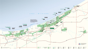  (click for larger maps) |
WEST BEACH
Swim, of course, but if it's too cold, grill at the picnic shelter, or
follow a trail through dunes and forest and learn about plant
succession—how plant communities replace each other over time. In
fall and spring watch migrating waterfowl at Long Lake.
PORTAGE LAKEFRONT AND RIVERWALK
New in 2008, this national lakeshore site also features a riverwalk,
accessible fishing pier, hike and bike trails, food service, ample
parking, and a breakwater.
COWLES BOG
Want to tackle this national park area's most rugged hike? The Cowles
Bog Trail takes you on a five-mile trek through wetlands and over wooded
dunes to an isolated beach.
BAILLY-CHELLBERG
Explore this 1820s fur trading post and 1900-era Swedish farmstead. A
trail winds through or by diverse habitats: the Mnoké Prairie, Little
Calumet River, and beech/maple woodland. Check the park website for
event schedules.
GLENWOOD DUNES
This is a trail for all seasons, with hiking, horseback riding, or
winter skiing through the wooded dunes and wetlands. You will need to
bring your own horse or skis.
LAKE VIEW
Lake View picnic area (wheelchair-accessible) overlooks Lake Michigan
and offers a shelter. Or park here and witness stunning sunset views.
DUNEWOOD CAMPGROUND
The campground is just over a mile south of Lake Michigan and offers
modern wheelchair-accessible restrooms and showers and wooded sites. It
is first-come, first-served, (fees). Open April through October.
MOUNT BALDY
Don't miss Mount Baldy, this national park area's most dynamic dune. It
stands 126 feet tall. Be sure to read the display panels by the parking
area. They tell you just how far and how fast this massive dune
moves!
PINHOOK BOG
You can tour this fascinating bog—the gift of one huge chunk of
stranded ice age ice—only on a ranger-led tour. The habitat is
fragile. All you see rests on sphagnum moss, even the boardwalk and
trees. Call the visitor center to find out when the next tour is
offered.
SHORELINE SAFETY & RAILROAD CROSSINGS, TOO!
Regulations and Safety
Lake Michigan can be deadly, as high waves, rip currents, and sharp
drop-offs along the lake bottom kill the unwary. Heed posted warnings.
Swim at your own risk.
More people die at railroad crossings than in the lake. Do not drive by lighted signals or crossing gates.
Plants, animals, and all natural and cultural features are protected by federal law. Private lands exist in the parklands; respect all private property and do not trespass.
For firearms regulations and more safety regulations and information see The Singing Sands free park newspaper or the park website www.nps.gov/indu.
Emergencies or criminal or suspicious activities: Please call 1-800-PARKTIP (727-5847).
Visitor Center Indiana Dunes Visitor Center, on US 20 and IN 49, is open every day but Thanksgiving, December 25, and January 1. Stop there for activity schedules, information, and bookstore.
Accessibility We strive to make our facilities, services, and programs accessible to all. Call or check our website.
Beach and Much More The map shows access to the park's 15 miles of beaches and the national park areas not connected to the main lakeshore area, Heron Rookery and Pinhook Bog. Their land and waterscapes are important reasons why Congress preserved the area for this and future generations.
Environmental Education and Other Special Things To Do The Douglas Center and other park areas offer day-use environmental education programs. The Dunes Learning Center is a residential facility for schools and other organizations. Go to www.duneslearningcenter.org.
Restrooms Restrooms are available at all sites except the Heron Rookery, Calumet Bike Trail, and Miller Woods area on weekends.
Please Note Indiana Dunes State Park has different regulations and charges fees and takes reservations. For state park information contact www.state.in.us/dnr.
Source: NPS Brochure (2013)
|
Establishment
Indiana Dunes National Park — February 15, 2019 |
For More Information Please Visit The  OFFICIAL NPS WEBSITE |
Documents
"A Signature of Time and Eternity": The Administrative History of Indiana Dunes National Lakeshore (HTML edition) (Ron Cockrell, 1988)
A Study of Impact of Man-Made Noise on Natural Sound Final Report: Volume I (Howard R. Schechter, January 1980)
An Archeological Overview and Assessment of Indiana Dunes National Lakeshore, Indiana Midwest Archeological Center Technical Report Series No. 97 (Dawn Bringelson and Jay T. Sturdevant, 2007)
An Ethnobotany of Indiana Dunes National Lakeshore: Plant Uses of the Ojibwa People (Rebecca S. Toupal and Kacy Hollenback, April 2009)
Analysis of Night-Spotlighting Counts for White-tailed Deer, Indiana Dunes National Lakeshore, 1991-2006 NPS Natural Resource Report NPS/GLKN/NRTR—2011/424 (H. Brian Underwood and Randy Knutson, February 2011)
Aquatic Studies in National Parks of the Upper Great Lakes States: Past Efforts and Future Directions NPS Technical Report NPS/NRWRD/NRTR-2005/334 (Brenda Moraska Lafrancois and Jay Glase, July 2005)
Bat Monitoring Protocol for the Great Lakes Inventory and Monitoring Network — Version 1.0 (NPS Natural Resource Report NPS/GLKN/NRR-2020/2126 (Katy G. Goodwin, May 2020)
Bioaccumulative Contaminants in Aquatic Food Webs in Six National Park Units of the Western Great Lakes Region: 2008-2012 NPS Natural Resource Report NPS/GLKN/NRR-2016/1302 (James G. Wiener, Roger J. Haro, Kristofer R. Rolfhus, Mark B. Sandheinrich, Sean W. Bailey and Ried M. Northwick, September 2016)
Chellberg Farm Cultural Landscape Report, Indian Dunes National Lakeshore (Quinn Evans Architects, May 2000)
Climate Change Scenario Planning Workshop Summary, Apostle Islands National Lakeshore, April 23-24, 2015 (Jonathan Star, Nicholas Fisichelli, Gregor Schuurman, Leigh Welling, Richard Rood and Laura Briley, 2015)
Cowles Bog Wetland Complex History; Inventory; Restoration Final Completion Report (Daniel Mason, 2009)
Cultural Landscape and Historic Structures Report: Bailly Homestead, Indian Dunes National Lakeshore, Porter, Indiana Volume 1, Part 1 (Draft, May 7, 2018)
Cultural Landscape and Historic Structures Report: Bailly Homestead, Indian Dunes National Lakeshore, Porter, Indiana Volume 2, Part 2 (Draft, May 7, 2018)
Effects of Seepage from Fly-Ash Settling Ponds and Construction Dewatering on Ground-Water Levels in the Cowles Unit, Indiana Dunes National Lakeshore, Indiana U.S. Geological Survey Water-Resources Investigations 78-138 (William Meyer and Patrick Tucci, January 1979)
Final White-tailed Deer Management Plan/Environmental Impact Statement, Indiana Dunes National Lakeshore (April 2012)
Forest Vegetation Monitoring at Indiana Dunes National Lakeshore NPS Natural Resource Technical Report NPS/GLKN/NRTR—2013/779 (Suzanne Sanders and Jessica Grochowski, July 2013)
Foundation Document, Indiana Dunes National Lakeshore, Indiana (July 2016)
Foundation Document Overview, Indiana Dunes National Lakeshore, Indiana (2016)
Fragile Dune Environments: Managing for Human Imapct (Wendy Z. Hultsman, undated)
General Management Plan: Indiana Dunes National Lakeshore (August 1997)
General Management Plan Amendment, Development Concept plan, Environmental Assessment: Indiana Dunes National Lakeshore, Indiana (September 1990)
Geologic Map of Indiana Dunes National Park (September 2020)
Geologic Resources Inventory Report, Indiana Dunes National Park NPS Natural Resource Report NPS/NRSS/GRD/NRR-2020/2196 (Trista L. Thornberry-Ehrlich, November 2020)
Great Lakes Junior Ranger Activity Book (Date Unknown; for reference purposes only)
Historic American Buildings Survey
Dunn Residence HABS No. IN-298 (Janice Slupski, 2002)
Henry Chandler Cowles (1869-1930) and Cowles Bog, Indiana: A Study in Historical Geography and the History of Ecology (Sara Gibbard Cook, 1980 revised 1999, ©Indiana Dunes National Lakeshore)
Historic Resource Study, Indiana Dunes National Lakeshore, Indiana (A. Berle Clemensen, February 1979)
Historic Structures Report: Armco-Ferro House (HS-06) (2005)
Historic Structures Report: Cypress Log Cabin (HS-8) & Guest House (HS-9) (2001)
Historic Structures Report: House of Tomorrow (HS-07) (2001)
Historic Structures Report: Wieboldt-Rostone House (HS-4) (2001)
Hydrogeology and Hydrochemistry of Dunes and Wetlands Along the South Shore of Lake Michigan, Indiana U.S. Geological Survey Open-File Report 92-139 (Robert J. Shedlock, D.A. Cohen, T.E. Imbrigiotta and T.A. Thompson, 1994)
Indiana Dunes Country Education Guide (Date Unknown; for reference purposes only)
Junior Rangers, Indiana Dunes National Park (Date Unknown; for reference purposes only)
Junior Rangers Activity Guide, Indiana Dunes National Park (2011; for reference purposes only)
Junior Rangers Activity Guide, Indiana Dunes National Park (2012; for reference purposes only)
Junior Wildland Firefighter Activity Booklet, Indiana Dunes National Park (Date Unknown; for reference purposes only)
Landsat-based Monitoring of Landscape Dynamics at Indiana Dunes National Lakeshore: 2007–2012 NPS Natural Resource Report NPS/GLKN/NRR—2015/1073 (Ulf B. Gafvert and Alan A. Kirschbaum, November 2015)
Little Calumet River Corridor Plan: Indiana Dunes National Lakeshore, Indiana (July 1991)
Long-Range Interpretive Plan, Indiana Dunes National Lakeshore (April 2011 )
Mammals of Indiana Dunes National Lakeshore Scientific Monograph NPS/NRINDU/NRSM-94/24 (John O. Whitaker, Jr., John Gibble and Eric Jkellmark, 1994)
Monitoring Water Quality of Inland Lakes, Great Lakes Network, 2009 and 2010: Data Summary Report NPS Natural Resources Data Series NPS/GLKN/NRDS-2011/163 (Joan E. Elias and Richard A. Damstra, May 2011)
Monitoring Water Quality of Inland Lakes, Great Lakes Network, 2011: Data Summary Report NPS Natural Resources Data Series NPS/GLKN/NRDS-2012/363 (Joan E. Elias and Richard A. Damstra, September 2012)
Monitoring Water Quality of Inland Lakes, Great Lakes Network, 2012: Data Summary Report NPS Natural Resources Data Series NPS/GLKN/NRDS-2014/629 (Richard A. Damstra, David Vander Meulen and Joan Elias, March 2014)
National Register of Historic Places Nomination Forms
Beverly Shores/Century of Progress Architectural District (Fay Hendry, J. Keith Everett, Thomas Hensley, Thomas Kuck and Jill York O'Bright, October 21, 1985)
Beverly Shores South Shore Railroad Station (Dorinda Partsch, August 9, 1988)
Cowles Bog (Amy Borland, Cooper Shields and Wes Cunningham, December 6, 2024)
Dr. John and Gerda Meyer House (Kurt West Garner, March 22, 2012)
Joseph Bailly Homestead and Cemetery (Fay L. Hendry, February 1, 1977)
West Beach Historic District (Amy Borland, Cooper Shields and Wes Cunningham, December 6, 2024)
Newsletter (Dunes Echo) (©Friends of Indiana Dunes)
2019: Winter • Summer • Fall • Winter
2020: Spring • Summer • Fall • Winter
2021: Spring • Summer • Fall • Winter
2022: Spring • Summer • Fall • Winter
2023: Spring • Summer • Fall • Winter
Notes on the Sand Dunes of Northwestern Indiana (George B. Cressey, extract from The Journal of Geology, Vol. 30 No. 3, April-May 1922)
Our Changing Landscape: Indiana Dunes National Lakeshore (HTML edition) U.S. Geological Survey Circular 1085 (Catherine L. Hill, Barbara J. Ryan, Bonnie A. McGregor and Marie Rust, 1991)
Park Newspaper (The Singing Sands): November/December 1980 • September 1990 • Summer 1993 • Fall 2006 • Summer 2007 • Fall 2007 • Summer 2008 • Fall 2008 • 2009 • 2010 • 2011 • 2012 • 2013 • 2014 • 2015 • 2016 • 2017 • Winter-Spring 2020 • 2021-2022 • 2022-2023 • 2023-2024 • 2024-2025 • 2025-2026
Report on the Proposed Sand Dunes National Park Indiana (Stephen T. Mather, 1917)
Shoreline Restoration and Management Plan/Draft Environmental Impact Statement (July 2012)
Songbird Monitoring in the Great Lakes Network Parks: 2014-2018 NPS Natural Resource Report NPS/GLKN/NRR-2021/2217 (Samuel G. Roberts, Zachary S. Ladin, Elizabeth L. Tymkiw, W. Gregory Shriver and Ted Gostomski, January 2021)
Special Flora and Vegetation of Indiana Dunes National Park NPS Natural Resource Report NPS/INDU/NRR-2024/2622 (Noel B. Pavlovic, Barbara Plampin, Gayle S. Tonkovich and David R. Hamilla, February 2024)
Special Vegetation of the Indiana Dunes National Lakeshore Research Program Report 90-02 (Gerould S. Wilhelm, January 1990)
Status of the Eastern Massasauga Rattlesnake at Indiana Dunes National Lakeshore NPS Natural Resource Technical Report NPS/GLKN/NRTR—2009/158 (Gary Glowacki and Ralph Grundel, January 2009)
The Bailly Area of Porter County, Indiana (Sarah Gibbard Cook and Robert S. Jackson, 1978)
The Dunes of Indiana (Sarah M. Farley, extract from The Mountaineer, Vol. Twelve, December 1919)
The Indiana Dunes — Legacy of Sand Indiana Department of Natural Resources Geological Survey Special Report 8 (John R. Hill, 1974)
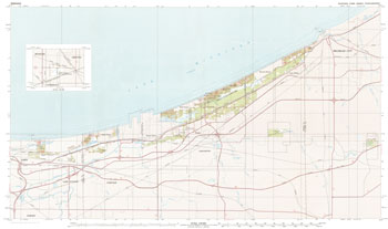
Topographic Map: Indiana Dunes National Lakeshore, IN Scale: 1:50,000 (USGS, 1980)
indu/index.htm
Last Updated: 16-May-2025