|
Managing Multiple Uses on National Forests, 1905-1995 A 90-year Learning Experience and It Isn't Finished Yet |
|
Chapter 5
Performance of Multiple-Use Management: 1970 to 1979
This chapter describes the national forest on-the-ground response to the growing demands for multiple uses and the rising pressures for greater environmental sensitivity and protection. It presents a fuller view of the setting for and national forest managers' response to the national policy issues of the 1970's and new congressionally enacted policy direction. Overall, national forest managers continued to respond to the expanding national and local national forest use demands but struggled to implement the new policy direction and the environmental and ecosystem emphases that were rapidly evolving from the national debates and public pressures.
The Internal Forest Service Setting: The 1970's
By 1970, many national forest managers and professional staff were deeply concerned about the direction national forest management was taking. Chief Cliff shared these concerns in a memo to all Forest Service employees (Cliff 1971a). He pointedly reported that programs were out of balance with the public's emerging environmental preferences and that criticisms were mounting on all sides. The national forests needed new direction, and the Forest Service was taking steps to achieve such changes. He cited the draft Environmental Program for the Future (EPF) as a leading initiative to shape these changes — through higher and more balanced congressional funding. The Chief stressed the need to heed President Nixon's response to the Softwood Timber and Plywood Task Force findings to intensify management to increase national forest timber supplies while protecting environmental quality. He also reiterated NEPA's strong requirements and the President's direction that Federal agencies carry out full pollution abatement on all Federal projects promptly.
The Chief felt the key to successfully achieving a more balanced resource emphasis and the new NEPA objectives was increased staffing and funding (Cliff 1971a). If such increases were not feasible, then current activities would have to be reprogrammed: timber sales, road construction, and structural improvements would need to be reduced; funding for wildlife, watershed, recreation, pollution control, and similar activities would need to be increased.
In July 1971, Chief Cliff summarized the public's view and outlook, as he saw them, before a joint meeting of the Western Association of State Game and Fish Commissioners and the Association of Midwest Fish and Game Commissioners in Aspen, Colorado:
The American public is demanding top quality in the management of natural resources and attention to the way things look. We are already involved in a number of lawsuits reflecting public awareness of our activities. The public is increasingly unhappy with us. This will continue until we get balance and quality into our program, as well as public involvement into our decisions. Until we do this, the course of the public entering into our fairly routine decisions through protests, appeals, and court cases will have the effect of reducing our ability to put timber on the market to help meet housing goals (Cliff 1971b).
Earlier, in January 1970, Chief Cliff had told regional foresters and experiment station directors that he was convinced that an ecosystem approach to the management of national forest uses would contribute to a better life for present and future generations. This approach would provide a high-quality environment for recreation opportunities, fish and wildlife, water, forage, and timber in harmony with the needs of lesser organisms. He encouraged his staff to review the current ecology and ecosystem management references and to participate in a national training program on ecosystem approaches to national forest management.
Following the traditional division of policy and management responsibilities between the national and field offices and the decentralized approach to managing multiple uses, the implementation of this approach and related training was left largely to regional foresters and forest supervisors and their professional staffs. Washington Office leadership would not refocus its multiple-use resource-management policy attention to the ecosystem approach explicitly again until the 1990's.

|
| C. Wayne Cook, Professor Emeritus of Range Science, Colorado State University, and the driving force in the introduction and development of the Ecosystem Management short course in the late 1960's. (Colorado State University.) |
National Forest Managers' Training in Ecosystem Management
Chief Cliff's views for linking the ecosystem approach to managing multiple uses on national forests were translated into a national ecosystem management training program for national forest managers. This program began in 1970 through joint Forest Service sponsorship of an Ecosystem Management Short Course with the Department of Range Science at Colorado State University. At that time, it was the first formal ecosystem management course offered at the university level in the United States (Cook 1994).
The Forest Service sponsorship led to substantial course additions and its expansion from 2 to 3 weeks. It was initially offered three times per year — later reduced to two weeks and two sessions per year — with a minimum of 35 students per session. Forest Service sponsorship continued into the early 1980's, when the program was superseded by the national training program for National Forest Management Planning. In the 12 or so years that it was offered, nearly 1,000 national forest managers and staff experts from the Chief's level down to the ranger district participated in it. Over the years, Forest Service participants made up more than 80 percent of the total enrollees (Cook 1994). Many Ecosystem Management Short Course graduates became trainees in the national forest management planning training program in the 1980's. Such enrollees provided a bridge for linking ecosystem management principles with national forest planning.
The range management background of many of the course instructors and the Department of Range Science influenced the general context of the course — forested and open rangelands — but it also addressed wildlife, timber, water, recreation opportunities, and related uses. The teaching focused on ecological principles and theory, with a strong emphasis on ecosystem structure and functions. The course's objective was to provide a generalized understanding of how ecosystems responded to different natural and anthropocentric influences and the importance of maintaining the integrity of ecosystem structure and functions. Instructors often supplemented this training with case studies and field observations. (Bartlett 1994; Cook 1994; Colorado State University undated).
The Washington Office did not furnish any central guidance for applying the ecosystem approach to managing national forest resources during the 1970's. Ecosystem principles were implemented by the trainees who took what they had learned about ecosystem functions and structures and applied it as they saw fit in their daily management work on the national forests. Ecosystem approaches to national forest resource management developed most strongly in connection with range and wildlife. But this emphasis naturally influenced the management of other resources — particularly timber. Early applications of an ecosystem approach within the National Forest System were quite uneven. They were hampered because managers saw uncertainties and risks with such applications, especially the barriers of the Forest Service's detailed manuals and management guides. Where ecosystem-oriented efforts deviated from manual guidelines and led to unacceptable results, or where supervisors saw aberrations from established guidelines, the ecosystem approach carried career risks for young foresters, resource specialists, and managers (Hartgraves 1994).
Even though the ecosystem approach was not formally adopted, there were many efforts and initiatives to incorporate its principles into managing national forest uses (Hartgraves 1994). One of the most important initiatives established a common framework for classifying National Forest System lands and resources by ecosystem characteristics. An ecosystem approach to national forest management needed to stratify forest and rangeland ecosystems as they lay on the land.

|
| Ecosystem Management short course participants received field instruction and experience to better understand the concept of ecosystem management. Field trips examined both rangeland and forested ecosystems. (Harold Goetz, Range Ecosystem Department, Colorado State University.) |
Classifying National Forest Lands and Resources
In the early 1970's, when national forest unit planning was getting underway, the Intermountain Region's regional forester initiated a project to provide a common framework for classifying heterogeneous lands and resources on the region's national forests. At that time, each functional staff had its own particular approach to land and resource classification and each forest developed its own classification system to fit its specific conditions. Such classifications were influenced by the particular background, training, and experience of the resource staff developing them. The goal of the Intermountain Region's project was to develop a common classification framework that would consistently predict management responses, distinguish ecosystem productivity differences, and be useful for timber, wildlife, fish, watershed, range, recreation planning and management, and the integration of multiple uses across the region (Sirmon 1994).
Robert Bailey, the Intermountain Region's ecological geographer, led the project. He mapped ecoregions (extensive geographical zones over which the macroclimate is sufficiently uniform to permit the development of similar ecosystems on sites with similar properties). Within the same ecoregion, such broad-scale landforms as mountains and valleys, extensive water bodies, swamps, or broad plains modified the "local" climate and led to secondary differences in the ecoregion structure and components. Ecoregion substratifications due to landform were called "landscapes." Due to different geographic patterns, an ecoregion could contain many landscapes. With this understanding of the relationship between climate and landforms, national forest resource people could consistently delineate and differentiate ecosystem units at several different scales depending on their needs and purposes and upon which questions decisionmakers at various levels would be asking. The variously sized ecosystem units provided a base for consistent estimates of ecosystem productivity, probable responses to management practices, and the interaction effects of such management among ecosystem units (Bailey 1983; 1987a). Because ecoregions and ecosystems units did not follow National Forest System boundaries, Bailey's approach was broadened to cover all ownerships.
In 1976, the Forest Service published the first map titled "Ecoregions of the United States" for the Department of the Interior's Fish and Wildlife Service, a cooperator in the project, to help compile its National Wetlands Inventory. The same map was used in the RARE II process to assess which eco-regions and lower level ecosystem components were not already represented in designated wildernesses.
Bailey's map was later used to identify and locate ecosystems not represented or underrepresented in the National Wilderness Preservation System. The Intermountain Region used Bailey's process in unit area planning and eventually in national forest land and resource management planning. Other regions also used the map, but in the absence of any central consistent direction within the National Forest System, each region applied different or additional criteria for its particular purposes.
National direction for implementing an ecosystem approach to managing multiple uses was to come almost two decades later in 1992, with the further development and refinement of the ecoregion framework and the technology for mapping lower level ecosystem units. In November 1993, David Unger, the Associate Chief of the Forest Service, issued a directive, "effective immediately," to begin using the National Hierarchical Framework of Ecological Units in land management planning, research programs, and cooperative efforts with other agencies and partners (Unger 1993; USDA Forest Service 1993a). This framework has been adopted by several Federal and State resource agencies, including the USDA Natural Resource Conservation Service (formerly the Soil Conservation Service), the BLM, the Fish and Wildlife Service, the Department of Commerce's National Oceanic and Atmospheric Administration, and the Minnesota and Michigan Departments of Natural Resources (Bailey 1987b; USDA Forest Service 1993a). Much of the basic work was developed during the 1970's. Bailey's ecosystem classification approach to meet the needs of the Intermountain Region was national in scope from the very beginning.
Timber Management
As the 1970's began, national forest managers became increasingly aware of needed changes in national forest timber harvesting and management to meet wilderness and recreation uses, environmental objectives, and timber harvest targets. Such needs called for the fuller use of timber and better land management. They included constructing minimum-impact roads that were better fitted to forest uses and environmental needs; using new and advanced logging methods in environmentally sensitive areas; expanding investment in intensive forest practices; using more successful and effective regeneration methods; planning and designing timber harvest units more carefully to meet landscape objectives; using downed timber more fully, and reducing slash; using environmentally sensitive slash disposal methods; and much more (Roth and Williams 1986a).
The findings of the Monongahela, Bitterroot, and Wyoming clearcutting studies, and the Forest Service's national evaluation of National Forest Management in a Quality Environment: Timber Productivity highlighted this need for change. Subsequent congressional hearings on clearcutting and court suits challenging clearcutting reinforced it. Further evidence surfaced in many other studies undertaken by national forest managers at all levels on clearcutting, regeneration success, timberland suitability, the adequacy of timber harvesting systems, logging methods, and road layouts and designs to meet nontimber forest uses and environmental protection needs; determining allowable cut levels; writing and revising timber sale contracts to increase environmental protection; and other aspects of timber harvesting and management.
Three National Forest System-wide actions were undertaken in 1972 and 1975 to improve timber harvesting and management on the ground: implementation of The Action Plan for National Forests in a Quality Environment, stratification of the commercial forest land (CFL) base, and shifting the planning approach to unit planning. The first action gave forest-wide direction for applying recommended on-the-ground solutions to the 30 problem situations outlined in the "National Forest Management in a Quality Environment" report. The second action implemented the findings from the study on "Stratification of Forest Land for Timber Management Planning on the Western National Forests" (Wikstrom 1971).
Stratification of the Commercial Forest Land Base
The 1971 stratification study was directed by the Intermountain Forest and Range Experiment Station and conducted by staff foresters from the six western regions. It evaluated the suitability and availability of the CFL base for growing tree crops on six national forests — one in each region. Taking careful account of soil and slope conditions, land productivity, and land use, major factors influencing suitability and availability, the study reduced the 4.2 million-acre CFL base by 22 percent to 3.2 million acres. An additional 13 percent of the remaining CFL was reported economically or technologically unavailable due to high operating costs, low product values, or terrain that was subject to high risks of erosion or environmental damage with current conventional logging methods (Wilkinson and Anderson 1985).
The stratification study concluded that the traditional differentiation of commercial and noncommercial national forest land had been oversimplified and inadequate for national forest planning — especially for timber management planning. The study recommended stratifying CFL into subclasses, including a "marginal utility" subclass for forestlands with problems of erosion, regeneration, or restocking on unstocked lands or that were otherwise economically and technologically unavailable. It also proposed that such areas be excluded from current cutting budgets to avoid overcutting the commercial timber growing base (Wilkinson and Anderson 1985). A May 1972 amendment to the Forest Service manual on timber management plans established a new classification system requiring CFL to be stratified into four components: standard, special, marginal, and unregulated and the use of the same calculation procedure to determine potential yields and allowable cuts for each.
The CFL standard component, the largest one, involved few or no adjustments to the calculated harvest for multiple-use objectives. The special component encompassed lands that had been zoned to protect waterways, riparian areas, travel ways, aesthetic areas, recreation areas, and other resources. Land within this component usually required specialized silvicultural prescriptions and modified harvesting methods. Light partial cuts, longer rotations, fewer or no thinnings, no cutting along streamsides, and other special practices usually reduced its programmed harvests. In some cases where special practices could be applied to meet multiple use objectives and environmental constraints, full yields could be realized (Newport 1973a).
In the marginal component, very little timber was sold or harvested. For example, in 1973 eight forests in the Northern, Southwest, and Pacific Northwest Regions with new timber plans had programmed an allowable cut of 51 million board feet per year for their marginal lands compared to a potential yield of 156 million board feet. Six of the eight forests had an allowable cut of zero for their marginal components compared to a potential yield of 92 million board feet per year (Newport 1973b; Wilkinson and Anderson 1985). The fourth, or unregulated, component included harvests from experimental forests, administrative sites, recreation sites, and tracts isolated from markets. Such areas were very limited.
The new classification system generally reduced the estimated allowable cut on the national forests. For the eight forests with new timber plans, the new allowable cut calculated for 1973 averaged 9 percent below that for January 1, 1972 (Newport 1973b). The reductions were almost entirely from lands withdrawn from CFL. Withdrawals were attributed to special component (multiple-use coordination) and marginal component (critical soil or slope, economic, and environmental problems). By 1977, national forest managers had classed more than a third of the CFL timber base as special or marginal (Wilkinson and Anderson 1985).
The Shift to the Unit Planning System
The third major action modifying timber management planning was the shift from multiple-use plans to unit plans. Each forest had up to 20 planning units, each made up of one or more drainage basins. In 1972, the planning objective for each national forest over the next 10 years became the preparation of an intensive land use plan for each of its units. Units where critical management decisions were to be made were given planning priority. This new system required timber management planners to follow the land allocations of the individual unit plans. In this approach, the areas that unit plans zoned for recreation, scenic landscape, travel influence, water influence, streamside, or critical soil also had to be classified as special or marginal in each forest's timber management plan. Unit plan allocations also reflected national and regional timber production goals — the first time that national forest planning policy required timber management planning and implementation to be explicitly coordinated with other multiple uses.
A May 1972 Forest Service manual amendment made another important revision for timber management plans — the whole national forest was to be the area base for allowable cut determinations rather than individual working circles. However, in most regions, regional office timber staffs continued to make the potential yield and allowable cut calculations. The forest timber staff provided data and information, advised on various aspects of allowable cut calculations, and wrote the final timber management plan (Newport 1973a).
The Nondeclining-Flow Policy and Its Measure: Potential Yield
With the help of computer technology and the Douglas-fir supply study in 1969 (USDA Forest Service 1969), national forest managers, for the first time, were able to simulate timber harvests, management, and growth, decade by decade, for several decades beyond the first rotation. Unexpectedly, the study results revealed that, under the existing management intensity, current national forest harvest levels could not be sustained after the old-growth inventories had been harvested in the Douglas-fir region of Washington, Oregon, and California. The study projected that, using existing management intensity, harvests would be reduced 45 percent after the first 100 years. The current harvest level could be sustained only if forests were more intensively managed (Wilkinson and Anderson 1985; Roth and Williams 1986b).
The findings shattered the traditional basis for determining sustainable harvest levels in western old-growth forests — estimating the annual allowable cut by dividing the total old-growth inventory by rotation age and adding the net annual growth of immature timber to it. As a result, national forests shifted the determination of allowable cuts to a nondeclining-flow policy based on the potential yields (or harvests) that second-growth forests could produce using existing timber management intensity. The western timber industry took strong exception, because this policy would immediately reduce the timber supply from western forests. The industry argued that such a policy would waste the old-growth timber inventories, which greatly exceeded the stocking levels for managed forests (Wilkinson and Anderson 1985).
Ultimately, a compromise based on intensified timber management avoided timber harvest reductions. This solution required the Administration and Congress to make a commitment to increase the second rotation's potential timber harvest volume by increasing the funding for current reforestation, thinning, timber stand improvement, and other intensive practices to accelerate the growth of young timber.
The influence of the expected increases in future timber growth and inventories (due to more intensive stand management) on the current allowable cuts was initially referred to as the "allowable cut effect" (ACE). It has since been renamed the "earned harvest effect" (EHE). However, there was no assurance that Congress and the Administration would sustain higher funding for more intensive timber management over time. Lack of this guarantee made the Forest Service cautious and reluctant to raise allowable cuts based on the EHE.
Nevertheless, the regional forester of the Pacific Northwest Region wanted to evaluate how the Douglas-fir Supply Study findings and methodology and the underlying implications of new computer technology and projection methods would influence planning and management activities and decisions in the region. He wanted to know the impacts on data, information, and skill requirements for planning allowable cut levels; on timber management practices and intensities for individual forests; and on potential second rotation yield calculations. He wanted to know what implications different mixes and levels of timber management practices or improvements in timber utilization standards would have on allowable cut decisions and future timber program planning and funding.
In the early 1970's, Washington State's Gifford Pinchot National Forest was chosen to pilot this evaluation. It had just updated its timber inventory, its 10-year timber management plan was due to be updated, and it was representative of other productive Douglas-fir forests in the Pacific Northwest. As the Washington Office became involved with the study and the questions it addressed, the study became a national pilot for responding to the Pacific Northwest Region's concerns.
The Gifford Pinchot study found that allowable cut determinations could no longer be made without related decisions about investments to intensify timber management and about the types and amounts of timber management practices that would produce the growth and inventories to sustain current harvest levels into the next rotation (Roth and Williams 1986a). In 1975, the Gifford Pinchot National Forest became the first national forest permitted to reflect the EHE in its allowable annual cut determinations. This action was based on Congress' commitment to provide annual funding needed to support the intensified management over the new timber plan's 10-year life (Wilkinson and Anderson 1985).
On the basis of anticipated funding and backed up by monitored annual performance, this new approach was extended to the entire National Forest System in the late 1970's. Timber management plans documented the acres and types of silvicultural treatments needed to sustain the selected allowable cut level. Annual monitoring of actual treatments and acres treated showed whether such treatments satisfied the 10-year timber management plans' planned treatment schedule. Where actual performance fell short, individual forests reduced their allowable cuts accordingly. If the performance followed the plan, the allowable cuts could be maintained. The Gifford Pinchot fulfilled its scheduled silvicultural treatments during the balance of the 1970's and to the end of its 10-year plan in 1984 (Roth and Williams 1986a).
In line with the Church Guidelines, the Forest Service recommended that the EHE be determined by relying on reforestation, thinnings, and stand improvements for which growth responses had been reasonably documented. Forest planners were discouraged from relying on other intensive practices, such as fertilization and irrigation, whose growth benefits were poorly documented or largely speculative for large parts of the country (Wilkinson and Anderson 1985). Funding for silvicultural examinations, reforestation, and timber stand improvement practices increased almost three times, from $50 million in 1968 to $147 million in 1979 (USDA Forest Service 1992a).
Silvicultural Practices
For silviculturists, the late 1960's and 1970's were a time of growing recognition of the need for more intensive silvicultural examination and management of the national forest timberlands. This was particularly true in the West, where timber management had focused heavily on protection, access development, harvest area dispersal, and natural regeneration. Often the key foresters in the western regions were the timber sale planners and supervisors who carried the principal production workload and produced the major revenues within the National Forest System. Generally, the less-experienced foresters and forestry technicians at the district level were assigned the regeneration and related silvicultural responsibilities (Roth and Williams 1986b). In the East, where national forests were made up largely of heavily cutover timberlands, timber management had focused more heavily on rehabilitating cutover stands, improving their growth and growing conditions, regenerating unstocked lands, and rebuilding growing stocks. This naturally called for more attention to silvicultural examinations, their diagnoses, and the development of silvicultural prescriptions to guide actual management practices.
Both in the East and in the West, national forest managers increasingly recognized the need for more effective silvicultural treatments, including coordination with other multiple uses. This was well evidenced during the Church hearings in 1971. But each region did much more to evaluate its own stand conditions and management needs. In 1974, for example, an evaluation of the timber situation in the Rocky Mountain national forests found that only a third of the harvested land was regenerating successfully. The research bulletin that reported this study characterized the reforestation failures as "galloping devastation" (USDA Forest Service 1974a).
An analysis of the performance of sanitation silvicultural practices in the old-growth ponderosa pine stands in eastern Washington and Oregon revealed that sanitation was not developing any young stands. Sanitation harvests removed old-growth ponderosa pine trees that were being attacked or were highly susceptible to attacks by bark beetles. Sanitation harvests usually removed about 40 percent of the stand volume, leaving 60 percent to grow. They were seen by the average person as selection cutting. But sanitation harvests were not providing the regeneration needed for the next rotation. The heavy emphasis on sanitation-salvage cutting often left residual stands inadequately stocked and frequently with decreased, damaged, and poorer quality regeneration (Burke 1985). The new silviculture called for complete harvesting of the sanitized stands to start new stands (Roth and Williams 1986a). The Pacific Southwest Region made similar discoveries in California.
In the Pacific Northwest, the most basic finding was that its national forests were not regenerating within 5 years after timber harvest — an NFMA requirement. The record "was not good." Part of the solution was retraining key forest staff. Many foresters returned to universities for a semester or more of retraining to bring them up to speed in silviculture (Roth and Williams 1986a).
Following Chief's Office direction, the first national forest program for training and certifying silviculturists was established in 1973 in the Northern Region, where the Bitterroot National Forest had been a focal point of the Church hearings. It was entitled Continuing Education in Forest Ecology and Silviculture (CEFES). The program recognized the larger context of ecosystems, but due to the narrow understanding and limited ecological science and knowledge at the time, its primary focus was largely on the stand and individual tree interactions and processes with the local environment. Several aspects of other resource interactions were included in the curriculum but not fully integrated into a broader ecosystem context.
Other regions followed with programs of their own over the next 5 years. Each regional program was approximately equivalent to a masters degree and constituted one requirement for silvicultural certification. The other requirements usually included 3 years of silvicultural field work and the successful defense of a silvicultural prescription before a panel of experts. The continuing education programs in forest ecology and silviculture were strongly coordinated with university programs and faculty and other resource management agencies. In the Northern Region, 461 natural resource professionals participated in the CEFES program. Half of that number were Northern Region foresters or resource experts.
As silvicultural and forest ecology training programs were getting underway in 1973, national forest managers also began to intensify on-the-ground silvicultural examinations and evaluations. Qualified certified silviculturists became responsible for determining stand conditions and the need for cultural treatments. The level of effort for such examinations rose from 101 FTE's in 1968 to 188 person-years in 1975, when each person was examining about 25,000 acres per year. By 1979, FTE's rose to 836 person-years, with one person examining an average of 11,000 acres per year.
Congressional emphasis on eliminating the reforestation backlog gave a big boost to silvicultural examinations. In 1976 and earlier years, less than 5 million acres were examined. This quickly rose to nearly 9 million acres per year by 1979. The goal of the silvicultural examination and diagnosis program was to provide site-specific silvicultural prescriptions prepared or approved by certified silviculturists for all forested lands needing treatment. Each stand was to be reexamined every 10 years to update its silvicultural prescriptions and to keep pace with changing forest conditions and management needs and new technology (USDA Forest Service 1979, 1980, 1992a).
During the same period, almost every region developed automated stand recordkeeping systems to maintain long-term stand condition and management records — making reporting silvicultural accomplishments easier and more reliable.
Most timber activities, including reforestation, timber stand improvement, and timber sale preparation were based on silvicultural prescriptions derived from stand examinations. In areas planned for timber harvests, such examinations and diagnoses reviewed stand conditions throughout the entire sale area, identifying stands that would benefit most from planned harvest and those that would benefit from such treatments as thinning (Murphy 1994). Silvicultural examinations also produced the data and prescriptions needed for the intensified unit planning process that emerged in the 1970's (USDA Forest Service 1980).
During 1978 and 1979, the silvicultural examination effort completed an NFMA-required inventory of all national forest lands in need of reforestation or thinning. This inventory included an estimate of the acres of treatment and the funds needed to eliminate the accumulated reforestation and timber stand improvement (TSI) backlog and to provide follow-up treatments on stands that would be harvested during the 8 years Congress had given the Forest Service to eliminate the backlog. As of October 1979, national forest lands needing of reforestation totaled 1.6 million acres; 882,000 were the result of timber harvest, fire, insects, disease, wind, and storms or failure of seeding, planting, or natural regeneration before 1975. The balance, 757,000 acres, was acreage that accrued after 1975. For TSI, generally precommercial thinning, the backlog was 2.2 million acres. Precommercial thinnings were needed to reduce the number of trees per acre and thereby increase overall stand health and individual tree growth. Thinning improved the health of stands by strengthening their resistance to drought, insects, disease, and other threats and increased the quality and value of their future growth. More than 400,000 acres of reforestation and 350,000 acres of TSI per year would be needed to eliminate the backlog (USDA Forest Service 1980).
The total acres reforested annually during the 1970's rose about 40 percent, from 313,000 acres in 1970 to 446,000 in 1979. Eighty percent were planted or seeded, while the remaining 20 percent were regenerated naturally. Twenty percent of the increase in regeneration treatments occurred between 1970 and 1977. The balance, 80 percent, was achieved in 1978 and 1979 in response to the newly developed inventory of backlog reforestation needs (USDA Forest Service 1972-1980).
TSI treatments during the 1970's rose almost 60 percent, from 303,000 acres in 1970 to 477,000 in 1979. TSI practices included thinnings and various other stand improvement measures such as fertilization, which was introduced in the early 1970's, and rose to more than 20,000 acres per year by 1976 (USDA Forest Service 1972-1980).
National forests continued to develop seed orchards and production areas to produce genetically improved for tree nurseries. The capacity of national forest seed extractories was increased as the production and collection of seeds increased. In 1970, for example, national forest seed extractories processed 22,000 pounds of seed. By 1979, they were processing 81,000 pounds. In 1976, the Forest Service initiated a major study of national forest nurseries to find out whether their existing capacity was capable of meeting the reforestation backlog of seedling needs and the needs resulting from new NFMA requirements. As a result of this study, two nurseries were added — one in the Southwest Region and the other in the Pacific Northwest.
Nursery tree production at the 13 national forest nurseries rose from 97 million trees in 1970 to 127 million in 1979. To increase planting stock survival rates on difficult reforestation sites, the nurseries also began producing containerized nursery stock. In 1979, they were providing more than 6 million containerized seedlings (USDA Forest Service 1972-1980).
The Forest Service developed standard methods for evaluating and certifying the effectiveness of silvicultural treatments in 1977 and implemented them in 1978. Regeneration could be certified successful after the third year for plantings and seedings and after the fifth year for natural regeneration. Failures, due primarily to insufficient tree survival, were recorded. Failures that needed further reforestation became a part of the reforestation backlog. TSI was certified in the first and third years after treatment. In 1979, national forests reported certified successful regeneration on 308,000 acres and certified success on 350,000 of TSI (USDA Forest Service 1978-1980).
In the 1970's, the intensification of silvicultural examinations increased the number and quality of silvicultural practices applied on the ground, improved tree and stand growth, and offset some of the impact of the nondeclining-flow policy on allowable cuts. The intensified silvicultural approach also reduced clearcutting, which had reached a peak of 564,000 acres in 1970 when timber was harvested from more than 1.5 million acres (Cliff 1971b). In 1978, as the timber harvest area rose to more than 2.6 million acres, the actual area clearcut was reduced to 310,000 acres — a 45-percent reduction in clearcut acres in 8 years (Forest Service 1992b).
Coordination of silvicultural examinations, planning, and treatments with other resource specialists likewise improved. But much of the coordination tended to be consultative and multidisciplinary rather than truly interdisciplinary. Although the NEPA environmental coordination precepts were available, national forests as a whole did not fully and mutually integrate resource specialists into the dominant timber management and harvesting tasks, which largely remained in the hands of the traditional timber staff. Thus, during the 1970's, a true, mutually interdisciplinary approach to timber and general resource planning and decisionmaking evolved slowly and in relatively few places (Roth and Williams 1986c).
Timber Harvests, Logging Systems, and Landscape Management
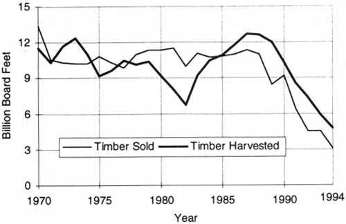
During the 1970's, the annual amount of national forest timber sold and harvested averaged about 11 bbf — about the same as for the 1960's (fig. 15). The average annual harvests, however, dropped from 11.4 bbf in the first half of the 1970's to 10.6 bbf in the second half. This reflected the decline of national housing and timber demands after the early 1970's (see fig. 10, chapter 4). The average annual volume of timber sold in this period was 0.5 bbf below the average annual volume sold and harvested in the last half of the 1960's (see fig. 6, chapter 3). This reduction largely reflected the influence of growing environmental pressures and the increased designation of wilderness.
|
| Figure 15. National forest timber sold and harvested, 1970-1994. Source: USDA Forest Service. |
During this period, the full annual harvests were concentrated on about two-thirds of the timber land base that was accessible and available for harvesting. This was due to the withholding of RARE I and RARE II roadless areas from harvesting in the absence of a final EIS evaluation of their suitability for wilderness. Because the Forest Service believed that RARE, then RARE II, would resolve the wilderness/roadless area issue in a few years, it kept the timber inventory in roadless areas in the CFL timber base and continued to sell and harvest the full allowable cut. From this viewpoint, it did not seem reasonable to cut back the annual allowable cut, close local mills, and cause unemployment for a relative short-term period. As a result, timber harvesting in already roaded areas was greatly accelerated throughout the 1970's, and this exacerbated environmental issues and concerns related to clearcutting.
This concentration of harvests began to cumulate pressures on related resources of forested rangeland, landscapes, and wildlife cover. Soil movement and stream sedimentation risks increased as larger-than-planned harvest areas had to be roaded and regenerated in the same watersheds. Mitigation efforts increased logging costs as more expensive logging methods and land treatments were required to protect other resources. The harvest concentration also contributed more to the public concern over national forest management than would have been experienced under the normally more dispersed timber harvest program (Roth and Williams 1986d). Throughout the 1970's, appeals and court actions became costly major obstacles to achieving the congressionally established and funded timber targets (USDA Forest Service 1979).
Logging Equipment: Methods and Systems
During the late 1960's, the need to improve logging equipment and systems to respond to the expanding environmental policies and standards and growing public concerns became increasingly clear throughout the National Forest System. Special harvesting methods without the environmental damage associated with ground yarding and road construction were needed to sustain national forest timber supplies (Newport 1973a).
The timber industry and loggers would require considerable persuasion and training to adopt new equipment and methods for felling and yarding timber. They had no independent incentive to make such changes unless such stipulations were built into the timber sale contracts. The timber industry and the loggers generally had only two basic logging systems: tractor yarding and high-lead (yarding with one end of the log on the ground). The high-lead system was largely used on national forests in western Washington and Oregon and northern California — an area where half of the total annual national forest timber harvest was concentrated. The Forest Service conducted special training programs for industrial, Federal, and State forestry personnel in California, Oregon, Washington, Idaho, and Montana to promote advanced cable and tractor logging systems that national forest managers, engineers, and resource specialists had determined would reduce timber harvesting's adverse impacts on soil and water (Roth and Williams 1986a; USDA Forest Service 1972).
The Pacific Northwest Region was the leader and innovator in new logging equipment and systems and fuller utilization of the timber sold, but this was also shared by other regions. It introduced the yarding of unutilized material (YUM yarding), which cleaned up many sale areas, made them easier to reforest, and added to timber supplies. During the 1970's and earlier, logging residues were generally considered cull material. They were widely scattered over each cutting unit or piled and usually burned. YUM yarding concentrated this material at a central landing point. The small material was difficult to sell, but, periodically, when the pulp market was strong or pulp mills experienced a wood shortage, many of the YUM piles were sold for pulp production. Others were taken for domestic fuelwood (Roth and Williams 1986a).
Other practices applied in the Pacific Northwest Region and elsewhere included requiring loggers to remove lower diameter materials from the sale area. As an incentive for purchasers, the smaller, less merchantable timber sale components were offered at a fixed lump-sum contract price per acre (Roth and Williams 1986a). Salvage logging was introduced to increase timber supplies and to reduce the loss of such timber to decay and insects. In 1977, Congress established a revolving timber salvage sale fund. By 1979, such sales added a billion board feet annually to national forest sale volumes. During the 1970's, the amount salvaged grew as timber markets and prices became stronger and receded in years when markets were weaker. The trend in the use of small timber materials followed a similar pattern (USDA Forest Service 1980; USDA Forest Service 1992a). National forests also instituted a free use-permit system so that people could cut dead timber for fuelwood. Before 1970, the use of national forest timber for home-heating fuelwood was nominal. By 1979, however, some 700,000 families were collecting a total of 3.2 million cords per year of national forest fuelwood — a trend that continues today (USDA Forest Service 1980). Directional felling of old-growth was introduced by the Pacific Northwest Region as a contract requirement to reduce tree breakage, improve tree utilization, and reduce erosion damage on steep slopes with shallow soils (Roth and Williams 1986a).
Perhaps the Pacific Northwest Region's most significant accomplishment toward better land management was the development, improvement, and diversification of entire logging systems and fitting them to the site-specific needs of individual harvest areas. The Pacific Northwest Region initiated a program for testing and demonstrating various forms of skyline logging (a system that lifts both ends of logs off the ground during yarding). Helicopter and balloon logging methods were also tested. Helicopter yarding proved to be very costly ($1,300 per hour of flight time) and ultimately was limited to areas where other logging systems could not be used on the timber sale and the environmental benefits and road-cost savings justified the costs.
|
| The typical logging road on Alaska's Tongass National Forest is also used for recreational fishing and hunting. (USDA Forest Service Photo. Taken by W.S. Cline) |
Most logging improvement focused on skyline logging systems that could operate on concave slopes and reach out laterally for 800- to 5,000-foot yarding distances. A Pacific Northwest Region survey of lands requiring such systems estimated that they contained a 40-bbf timber inventory — equivalent to an annual allowable cut of 0.4 to 0.5 bbf over 100 years (Roth and Williams 1986a; Newport 1973b).
The skyline logging development program offered several practical challenges. National forest engineers were basically trained as civil, not logging, engineers. Forestry schools' logging engineering programs had been greatly retrenched or eliminated. Thus, there was a major challenge to recruit and/or train logging engineers who could test, evaluate, and demonstrate advanced logging systems. These logging systems needed to be evaluated on both environmental and economic criteria to ensure that they would be successfully adopted on national forests by the timber industry. A third challenge was to develop and provide training programs for technicians on how to use the advanced logging systems and for line and staff officers on how to design timber contract specifications for using these advanced logging systems. During the 1970's and later, the Forest Engineering Institute (FEI) at Oregon State University met these challenges. It provided a month-long course for technicians and a 1- or 2-year training program for professional foresters and engineers. A research and development program to improve existing and develop advanced logging systems called FALCON (Forestry, Advanced Logging, and Conservation) was proposed and funded from existing national forest appropriations for a 5-year period. FALCON's second component was to study the compatibility of different logging systems with various resources and their impact on those resources. A third component established a demonstration area in the Pansy Creek drainage on Oregon's Mount Hood National Forest where a person could observe all the different logging systems and their impacts on the resources of a harvested area and its surrounding sites (Roth and Williams 1986a).
Road Design and Construction
The Pacific Northwest Region modified road designs and construction to reduce their impact on soil and water resources — particularly where roads served individual harvest settings and otherwise carried light traffic volumes. Civil engineers managed the national forest road program and set road design standards. The Forest Service began to use civil engineers in the early 1950's when national forest logging and road construction began to expand rapidly. Prior to that time, forest engineers were primarily forestry school logging engineering graduates.
Civil engineers were trained primarily to meet urban and highway engineering standards and the roads that they designed for lower class forest roads often exceeded the standards needed or required for forest use and management. These roads were generally too wide and were built to too high a standard. They involved larger volumes of sidecast rocks and soils than necessary to maintain their grades and widths. Excess material was often pushed over roadsides, where it became an erosion and sedimentation problem.
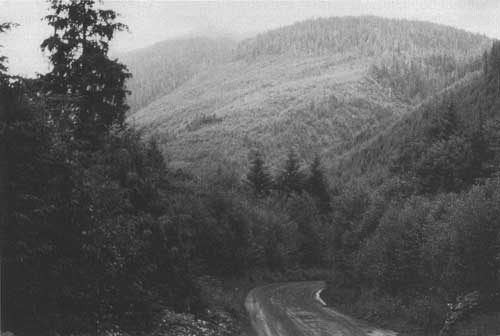
This problem was familiar to and a concern of national forest managers throughout the system, but it took Regional Forester Rex Ressler's leadership to bring this situation to a head in Washington and Oregon. A region-wide forest supervisor s meeting — an historic first for such meetings — was held on a timber sale road where alternative road standards could be thoroughly reviewed and discussed in relation to actual ground conditions and environmental needs. The meeting's outcome was clear direction from the regional forester to design and build what came to be known as "minimum-impact roads." Minimum-impact roads were narrower, had less sidecast material, and required less end hauling. They required no special surfacing material and less rock. Compared to the impact of the previous higher standard road designs, they substantially reduced the scarring of hillside landscapes. Minimum-impact roads were increasingly used in the Pacific Northwest Region during the 1970's, and their use continues today. Similar road design and construction improvements were made in other regions (Roth and Williams 1986a).
During the 1970's, almost 75,000 net miles were added to the national forest road system (fig. 16). Road construction and reconstruction (rebuilding existing roads that had been degraded or did not meet existing design standards or reopening closed roads) averaged 9,494 miles per year for the decade. (USDA Forest Service 1972-1980). Most of the reconstruction was concentrated in the regions with the largest timber harvest volumes. In the Pacific Northwest Region, for example, which harvested more than 42 percent of the total national forest timber cut during the 1970's, reconstruction constituted almost half of the total road construction (Coghlan 1995). Reconstruction of existing roads to current requirements and standards did not count as net additional road mileage. Roads actually constructed and reconstructed in the 1970's totaled 94,944 miles, more than the net increase in the total miles of national forest roads. Only 6.4 percent, or 6,013 miles, of these roads were funded by direct congressional appropriations. The vast majority were built by timber operators and funded by timber sale proceeds (purchaser credit). Purchaser-built roads were primarily logging spur roads and some secondary or collector roads. Mainline access roads were usually funded with appropriated funds and often included standards necessary to meet recreation traffic requirements as well as mainline road needs for loggers to reach public highways.

|
| Figure 16. Total road mileage in the National Forest System, 1967-1995. Source: USDA Forest service 1996. Data provided by Washington Office Engineering. |
Landscape Management
In the late 1960's, national forest managers recognized that sustaining timber harvests would require blending the location and design of timber harvest areas and roads with the general landscape in ways that protected visual quality. This need led to a new landscape management approach that provided a harvest layout design that responded to the public's interest in landscape views and vistas while achieving timber harvest objectives (USDA Forest Service 1972, 1974).
|
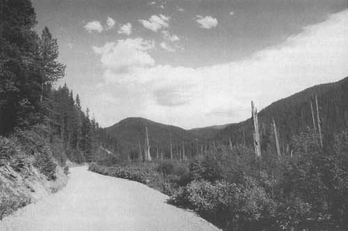
| Moon Pass Road, Idaho Panhandle National Forest, where it passes cedar swamp snags and forest regrowth from the 1910 fire. This gravel-surfaced road is cooperatively maintained by the Forest Service and Shoshone County, mainly for recreation in the summer and snowmobiling in the winter. (USDA Forest Service Photo.) |
While the first efforts to integrate harvest locations and boundaries with the natural landscape emerged in California, systematic visual resource management guidelines emerged in Oregon and Washington. At the Chief's request, a silviculturist and landscape architect combined their skills to prepare a regional guide as the first component of a national manual released in 1974 under the title National Forest Landscape Management (USDA Forest Service 1974b; Roth and Williams 1986a). This manual identified visual landscape characteristics and provided guidelines to analyze the visual effects of different timber harvest alternatives. Its main purpose was to help national forest managers coordinate timber harvest designs and plans with maintaining acceptable vistas. Such landscape management involved both the location and shaping of timber harvest units. During the 1970's, national forest managers recruited the Nation's, and perhaps the world's, largest staff of landscape and environmental experts to plan timber harvest area landscapes. Such specialists became skilled in harmonizing national forest installations such as roads, log landings, ski lifts, and other signs of land management with nature's woods and natural beauty.
Chapters on range and roads were added to the National Forest Landscape Management series in 1977. These handbooks provided vocabulary, planning guidelines, and an objective-setting process. The range chapter offered ideas on acceptable manipulation of forage vegetation and the installation of range improvement structures. The roads chapter provided methods to reduce the visual impact of roads so that they "lay lightly upon the land" (USDA Forest Service 1978). A supplemental report, "Land Use Planning Simulation," described how the visual impacts of proposed timber sale areas, power lines, surface mining, and other land uses and installations could be evaluated by projecting visual impacts on a screen. This became a useful tool in providing large groups of people the opportunity to see and react to the visual effects of various timber harvest alternatives. In 1978 and 1979, additional chapters on timber and wildlife were prepared. They illustrated methods for combining visual resource management with silvicultural and wildlife habitat practices to achieve attractive as well as productive landscapes.
The use of the National Forest Landscape Management Handbook broadened beyond national forests as demands for the publication and its concepts from universities, other Government agencies, and the public grew throughout the 1970's (USDA Forest Service 1978-80). To reflect the substantial advances in research and technology since 1974 and respond to a significant increase in the demand for high-quality scenery, the 1974 handbook was revised and updated and released in August 1996 under the new title Landscape Aesthetics: A Handbook for Scenery Management.
By 1979, all national forest regions had completed analysis and mapping of that 40 percent of National Forest System lands where visual quality objectives needed to be integrated with forest management activities. This helped to ensure that the scenic aspects of such land areas would taken into account as growing national forest land use and management shaped their future direction.
Wilderness Management and Use
Much of the wilderness management effort in the 1970's was devoted to wilderness planning for RARE I and RARE II and evaluating the 5.5 million acres in 34 national forest primitive areas that Congress had assigned for further study in the Wilderness Act of 1964. National forest primitive area evaluations were completed on schedule. By September 1974, all 34 areas had been recommended to Congress for designation and had actually been designated as wilderness. In the same year, the national forests celebrated the 50th anniversary of the designation of the first administrative wilderness in the Nation — the Gila Wilderness — with commemorative ceremonies held in Silver City, New Mexico. The celebration was held within sight of that first wilderness established on national forest lands.
The expanding number, area, and use of national forest wildernesses increased the wilderness management challenge in every dimension in the 1970's. Their number rose by 80 percent, from 61 to 110. Their area increased from 9.9 million acres to 15.3 million (55 percent). Their dispersion among the States rose from 13 in 1970 — 10 in the Far West plus Minnesota, New Hampshire, and North Carolina — to 26 States in 1979. Twelve of the new States were in the East, a reflection of the eastern wilderness legislation: Alabama, Arkansas, Florida, Georgia, Kentucky, Missouri, South Carolina, Tennessee, Vermont, Virginia, West Virginia, and Wisconsin. Utah was the thirteenth. But, even with this wider dispersion of wilderness areas, some 92 percent of the total designated wilderness remained concentrated in the eight Rocky Mountain States and the three Pacific Coast States (USDI/USDA 1970-1980).
The growing number and expanse of designated wilderness areas multiplied the need for wilderness management plans. By 1979, management plans had been completed and implemented for 46 areas. Planning was under way for another 38 and pending for most of the 24 units added in 1978. No areas were added in 1979. The new national forest land and resource management planning guidelines issued in 1979 fully integrated designated wilderness management direction into the new forest plans.
A 1970 study, prepared by the Department of the Interior in consultation with national forest mining specialists updating the 1961 and 1964 reports to Congress on wilderness mining activities, reported 18,000 unpatented mining claims and 1,500 patented claims in designated wilderness and primitive areas. In the 1964 Wilderness Act, Congress had directed that these mineralized areas, located on 34 national forests, be evaluated and that recommendations be made on their suitability for wilderness. The mineral reviews for these areas were completed and published in 1973 by the U.S. Geological Survey and Bureau of Mines (USDI/USDA 1970-1980).
The most demanding challenge facing national forest wilderness managers in 1970 was the preservation of the wilderness resource and its pristine conditions in the face of rapidly rising use, which in that year exceeded 5 million RVD's. The management experience to 1970 also clearly demonstrated a rising trend of wilderness use violations; these exceeded 200 per year and involved 173 prosecutions. Many violations were unintentional, where violators generally failed to comply with Forest Service regulations. Many users were either unaware that they had entered wilderness areas or were uninformed about wilderness restrictions — indicating a priority for wilderness user education and clearly marked wilderness boundaries (USDI/USDA 1970-1980).
National forest managers were participating and assisting wilderness search and rescue operations, which were likewise increasing. In 1971, for example, there were 84. A rising number of fatalities were also being reported each year. In 1971, there were 16 — four lives were lost in airplane accidents and 12 fatalities occurred as people were testing their skills against the wilderness. Many more people suffered serious injuries during their wilderness activities. Such instances were expected to occur more often as the number of wildernesses and users continued to grow.
A more systematic problem was occurring at the most popular lakes, streams, and other scenic or attractive spots in the wildernesses, particularly those near highly populated urban areas or in areas that were otherwise readily accessible. Many groups and individuals visiting such attractions were not seeking, or often did not have the skills to meet, the challenges wilderness offered. The intensity of use around many such spots was rising to the point that it was threatening the quality of the wilderness resource. Thus, in the early 1970's, the following wilderness management priorities emerged: preparing and distributing educational information on wilderness restrictions, ethics, and safety to users; posting wilderness boundaries; establishing proper people-carrying capacities for wilderness and managing use accordingly; cleaning up human debris and waste; providing sanitation controls; removing nonconforming structures and developments; and administering grazing and mineral exploration activities as permitted by the Wilderness Act.
To serve the preferences of national forest visitors seeking primitive-type offroad activities without the need to do so in a formally designated wilderness, national forest managers expanded complementary space and sites outside the wilderness for back-country hiking, camping, hunting, fishing, and other roadless recreation activities.
During the 1970's, the number of wilderness visitor days rose by 85 percent. This compares with a 27-percent increase in the total acreage of national forest wilderness and primitive areas available for wilderness experience and activity (fig. 17). The available area rose from 14.3 million acres in 1968 to 18.1 million in 1979. Thus, the intensity of use of wilderness opportunities nearly doubled in the 1970's. This rapid growth in wilderness use contrasts with a 35-percent increase in total outdoor RVD use on national forests during the same period.

|
| Figure 17. National forest wilderness area and visitor use, 1965-1994. Source: USDA Forest Service. |
On a State-wide basis, California, with 13 percent of total available national forest wilderness and primitive area in 1979, continued to receive the most RVD use — about 20 percent of the total. The Boundary Waters Canoe Area in Minnesota, with 5 percent of the available wilderness and primitive area, however, was the single most intensively used wilderness. It provided 12 percent of the total national forest wilderness visitor day use. Together, the California wildernesses and Boundary Waters Canoe Area accounted for almost a third of national forest wilderness use.
|
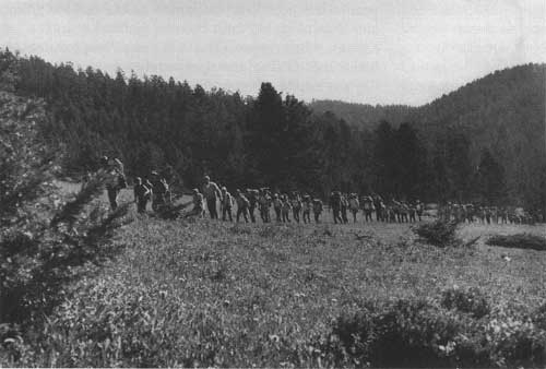
| Fifty-four wilderness hikers crossing Bear Prairie on the annual "Gates of the Mountains" wilderness hike, Helena National Forest, Montana, 1970. (Forest Service Photo Collection, National Agricultural Library. Taken by Philip G. Schlamp.) |
To manage wilderness use consistent with its capacity and capability, national forest managers introduced a wilderness permit system in the early 1970's. They expanded its use wherever it would help to ensure that wilderness resources would be properly and safely used and would help to control human debris and waste. By 1979, 50 percent of wildernesses and primitive areas, including all California wildernesses and the Boundary Waters Canoe Area, were under the permit system. Where it was implemented, the permit system generally worked satisfactorily and improved wilderness management effectiveness. Permit issuance, either by a staff person or volunteer at a wilderness trailhead or at the local ranger district office, gave national forest employees the opportunity to communicate directly with wilderness users and inform them about wilderness care and use. Wilderness users appreciated and responded to this information. Where permits were used, national forest managers reported less litter and reduced ecological impacts (USDI/USDA 1970-1980). Individuals, groups, and organizations who were interested in maintaining a high-quality national forest wilderness system increasingly volunteered work on projects. They communicated with visitors, performed searches and rescues, maintained signs and trails, cleaned up campsites, removed debris, and performed various other supporting functions.
The dominant recreation activities among wilderness users in the 1970's were hiking; horseback riding with pack stock and backpacking, usually with guide services; camping; hunting; fishing; and mountain climbing. In the late 1970's, winter wilderness activities were becoming more popular in some places and were seen as likely to increase the need for search and rescue operations, which were ranging between 265 and 310 per year. In the late 1970's, fatalities averaged more than 40 per year. Many could have been prevented with better understanding about how to meet nature on its terms, how to effectively prepare for emergencies, and how to develop skills in wilderness activities and conditions.
Trespass and violations increased during the 1970's despite the improved intensity of wilderness information, supervision, and management. In 1976, they reached a peak of 794 and remained a continuing problem for the balance of the decade. Wilderness violations involved various forms of motorized equipment, occupying and using wilderness without a permit, not complying with a wilderness permit, and violating special wilderness restrictions. In 1978, two incidents of armed robbery and one murder required coordination with local law enforcement authorities (USDA/USDI 1970-1980).
Although wilderness interests were successful in getting Congress to endorse lower than pristine standards for wilderness candidate areas and wilderness designation, the management of national forest wilderness continued to be guided by pristine standards. Wilderness interests did not oppose them — although some users complained about permitted livestock grazing and horse use, legitimate mining activities, thefts, low-flying aircraft, and, in some places, the permit system.
Outdoor Recreation Use and Management
RVD use for a wide variety of recreation activities grew throughout the decade, despite rising concerns and issues among various resource interest groups and some users about wilderness preservation, timber harvest levels and related road construction, and clearcutting, all of which probably contributed to the culmination of the wilderness preservation, timber harvesting, and clearcutting issues during the 1970's. National forest management of multiple uses, on the other hand, encouraged and helped make this growth possible.
Growth in Total Visitor Use
National forest outdoor recreation use in the 1970's increased from 163 million RVD's in 1969 to 220 million in 1979 (see fig. 8, chapter 3). While annual RVD use on other Federal lands, mainly national parks, declined after 1976 by nearly 30 million RVD's, outdoor recreation use on national forests continued to rise by more than 20 million RVD's. Fitting these expanding demands for outdoor recreation opportunities with other uses on national forests became and remained a major management challenge for national forest managers throughout the decade (USDA Forest Service 1970-1980).
Visitor use and growth were concentrated in the western national forests. The seven western national forest regions accounted for 78 percent of the RVD use and more than 80 percent of the RVD growth during the 1970's. The western regions included the Pacific Coast and Rocky Mountain States plus Alaska, North and South Dakota, Nebraska, and Kansas. They made up barely 20 percent of the U.S. population, but had more than 90 percent of the national forest area. Visitor use was largely local or regional and averaged 3.5 RVD's for each western person each year. The intensity of use varied by State from 2 to 3 RVD's per person per year in South Dakota and the most populous States of California and Washington to 10 to 12 RVD's per person per year in less populous States such as Idaho, Montana, and Wyoming. In North Dakota, Nebraska, and Kansas, where national forest acreage was minimal, national forest use averaged barely a tenth of a visitor day per capita per year (Poudel 1986).
RVD use on national forests in the East totaled 36 million in 1969 and was about equally divided between the Southern Region and the Lake States and Northeastern Regions (combined and called the Eastern Region in mid-1970's). By 1979, it had risen by 32 percent, to 48 million. Almost 85 percent of the increase had occurred in the Southern Region. Because the population in the East is very dense and highly urbanized, average per capita use per State among the Eastern States was very low. Although national forest acreage in the East was small, and constituted less than 12 percent of the area of the National Forest System, it was used twice as intensively as that in the West (Poudel 1986).
Camping accounted for more than 23 percent of the increase in RVD use on all national forests. It rose by 13 million RVD's between 1969 and 1979. Motorized travel through and within national forests for general viewing and accessing specific recreation sites and opportunities accounted for 20 percent of the RVD increase, rising by 17 million during the decade to 50 million. Safe, drivable roads became important during the 1970's, not only for viewing the forest and its mountain scenes and environment, but also for accessing the wide variety of recreation resources — streams, lakes, mountainsides, and trails and the developed sites for camping, boating, swimming, skiing, and other activities (Poudel 1986).
Outdoor recreation visitors to national forests typically devoted about 38 percent of their RVD's to activities in developed sites such as campgrounds and picnic areas; winter sports sites; water developed for boating and swimming; observation sites; various interpretive, informational, and documentary facilities; fishing areas and trailheads; playgrounds, parks, and sports fields; recreation residences; and hotels, lodges, resorts, and concessions. Visitors devoted about 42 percent of their RVD's to dispersed recreation activities throughout the national forests and an additional 20 percent to motorized travel on forest roads (Poudel 1986).
Staffing for Recreation Management
National forest staffing for recreation planning and management and operations and maintenance generally followed the upward trend in RVD use. Professional and support services rose by 35 percent between 1973 and 1979, from 4,300 FTE person-years to 5,900 FTE's (USDA 1992a). Almost 95 percent of the staffing was directed to general recreation and served both developed and dispersed recreation sites, opportunities, and uses. This included landscape planning, which was a growing component of the recreation function during the 1970's and worked closely with timber sale planners and road engineers. The remaining 5 percent of the staffing was directed to cultural resources and wilderness management.
National forest managers also graciously and generously used human-resource programs and volunteers to accomplish a large part of their expanding operational, maintenance, and construction work needed to support rapidly growing recreation use and activities on national forests. The programs (shown with their dates of initiation on national forests) include the Job Corps (1965); the Youth Conservation Corps (1971); Volunteers in the National Forest (1973); the Senior Community Service Employment Program (1974); the Young Adult Conservation Corps (1977) and various hosted programs (1960's-1970's) of other agencies, States, and the private sector, such as College Work Study, the Work Incentive Program, Vocational Work Study, and programs authorized under the Comprehensive Employment and Training Act of 1973 (CETA).
These programs provided conservation education through natural resource activities on national forests, skills training, employment, and national service opportunities for the unemployed, underemployed, minorities, disadvantaged, youth, elderly, retired people, and persons with disabilities. Through conservation work projects, participants made valuable, increasing contributions to visitor information services, recreation site and facility maintenance, camp unit construction, trail maintenance and construction, and clerical support through out the 1970's. The total work provided by human resource programs and volunteers rose from less than 4,000 person-years in 1970 to more than 6,000 person-years in 1975, and more than 16,100 person-years in 1979. The great growth after 1975 was largely due to the initiation of the Young Adult Conservation Corps in 1977 and expansion of the Youth Conservation Corps and Senior Community Service Employment programs during the 1970's. The number of volunteers continued to expand rapidly after 1975 (USDA Forest Service 1972-1980).
In 1979, 93 percent of the total services available to the Forest Service from human-resource programs were used on national forests. Recreation resources and users received a major share. Other resources benefitting from these services were timber stands and wildlife habitats. The total estimated value of all human-resource services provided to the Forest Service in 1979 was $164 million and compared with $28 million in 1975 and about $13 million in 1970, measured in constant 1979 dollars (USDA Forest Service 1972-1980).
Capacity and Use at Developed Sites
In addition to upgrading the sanitary facilities at developed recreation sites, the annual recreation investment on national forests in the 1970's rehabilitated many deteriorating sites and constructed some new ones. Between 1970 and 1979, Federal and private investments increased the capacity of national forest developed recreation sites for visitor use occupancy by 12.6 percent. Use at developed sites rose by 21.0 percent during this same period, to 81.9 million RVD's — more than the capacity of developed sites could accommodate (fig. 18). Forty percent of this increased use was accommodated by more effective and intensive use of existing sites during the recreation season. Recreation visitors were encouraged to use available existing sites on weekdays rather than weekends. To achieve fuller use of the available developed sites, new sites or those replacing abandoned sites were located in areas of stronger recreation demand and greater user access (Poudel 1986).
|
| Figure 18. Developed outdoor recreation site capacity and use, 1970 and 1979. Source: USDA Forest Service. |
National forests operated 53 percent of the total occupancy potential at developed sites. The balance was privately operated, usually with privately constructed facilities, under the national forest special use permit system. The privately operated facilities included all recreation residences and public concession sites; most of the hotels, lodges, and resorts; some winter sports sites and boat marinas; and organizational camps administered by youth organizations and other groups. Privately operated developed-site occupancy capacity increased by 15 percent during the 1970's; national forest occupancy capacity increased by almost 10 percent (Poudel 1986).
The largest occupancy capacity increase occurred at winter sports sites, which grew by 43 percent during the 1970's. RVD use of winter sports sites, mainly ski areas and other facilities, increased by 6.4 million, or 98 percent. The next largest increase in RVD use occurred in campgrounds. It grew by 4.1 million RVD's, or 10 percent, and was accommodated primarily by more intensive use of existing sites. The use, however, shifted among campground sizes and types of camp units. Over the decade, a third of the campgrounds with 25 or less units were shut down and their capacity replaced by expansion of larger existing campgrounds and by constructing new, larger ones. Between them, campgrounds and winter sports sites accounted for 75 percent of the increased use at developed sites between 1970 and 1979. Boating sites and interpretive sites each accounted for an increase of 1.1 million RVD's of use and about 15 percent of the total increase. Occupancy capacity for each rose between 50 and 60 percent.
Visitor use of hotels, lodges, resorts, and public service concessions increased by 800,000 RVD's, or 17 percent, and was accommodated largely through increased use of existing facilities. On the other hand, recreational residence use declined by 900,000 RVD's as national forest managers reduced the number of recreation residence permits. Beginning in the late 1960's, national forest policy called for a shift in the use of isolated individual private recreation residence sites to public purposes. Where public values exceeded those for continued private use, existing permits for some of the more isolated residence sites would be canceled and no new permits would be issued for establishing any additional private recreational residences. Permits for recreation residences that were located in established residential tracts were not subject to cancellation (USDA Forest Service 1969, 1978-1980).
Other uses, such as swimming, picnicking, and scenic observation, also grew, between 400,000 and 450,000 RVD's, and were accommodated primarily through more effective use of existing sites. The number and capacity of picnic areas and scenic observation sites were reduced. Visitor use at existing playgrounds, parks, and sports sites quadrupled from 1970 to 1976 and led to expanding existing sites and building new sites that doubled occupancy capacity during that period. A further doubling of capacity by 1979, however, proved excessive and was not fully utilized until well into the 1980's (Poudel 1986).
Finding ways to more fully use existing developed site facilities, providing supervision and information, and meeting the higher maintenance needs of more intensive use were major management achievements in the 1970's. Human-resource and volunteer programs contributed importantly to these achievements. The effectiveness of this effort is reflected in the maintenance of fully 74 percent of the forest-operated developed sites at the "full service" level for visitor use and enjoyment in 1978, primarily at the more intensively used sites. Only 26 percent received a "reduced level" of maintenance and service for visitor use. In 1979, however, the developed sites receiving full-service maintenance fell to 69 percent as the fast-growing use continued to strain available, but limited, national forest resources for recreational facility management and maintenance. Congressional funding for recreation management was escalated in 1978 and 1979 to help meet the need for higher maintenance and, in some instances, rehabilitation of deteriorating sites (Poudel 1986).
National Forest Trails
The national forests fully maintained 98,000 miles of trails in the 1970's (Poudel 1986; USDA Forest Service 1992a). In 20 States — Arizona, Colorado, New Mexico, Nebraska, Wyoming, North and South Carolina, Georgia, Florida, Mississippi, Louisiana, Texas, Oklahoma, Arkansas, Tennessee, Pennsylvania, Indiana, Missouri, Wisconsin, and Minnesota — and Puerto Rico, trail use increased an average of 4.2 times, from a million RVD's to 4.2 million RVD's, between 1969 and in 1979. As trail use by recreation visitors continued to escalate rapidly, the total miles of trail constructed and reconstructed with Federal funds rose from an average of 283 miles per year from 1970 to 1976 to 1,052 miles per year between 1977 and 1979. Human-resource and volunteer programs also rebuilt existing trails or built new ones. In 1970, volunteers built only 50 miles of trail; in 1978 they built 1,236 miles, and in 1979, 878 miles, approximately equaling the trail miles constructed with Federal funds in the late 1970's (USDA Forest Service 1972-1980; USDA Forest Service 1992a).
Trails generally provided recreation opportunities for hiking and horseback riding with pack animals. But, some were designed for bicycling, snowmobiling or other offroad vehicles (ORV's), and cross-country skiing. Trails also provided access to the backcountry, including wilderness, as well as pathways to reach undeveloped recreation areas such as mountain climbing sites, lakes, streams, and mountaintops.
Congress designated both the Appalachian Trail and the Pacific Crest Trail as national scenic trails in 1968. During the 1970's, national forests constructed or reconstructed more than 90 percent of the 840-mile Appalachian National Scenic Trail and 76 percent of the 2,600-mile Pacific Crest National Scenic Trail (USDA Forest Service 1980). By 1977, national forest managers had evaluated and designated 14 additional national recreation trails. However, President Carter, in his environmental message for FY 1979, expanded the goal to designating 244 national recreation trails on national forests by 1980. This goal was exceeded. At the end of 1978 there were 69 national recreation trails, and by the end of 1979 there were 256, totaling 2,986 miles. Many trails were located near large population concentrations. Much like the regular national forest trails, they were designed mainly for foot travel, but some provided for bicycles, horses, snowmobiles and other ORV's, and others were designed for cross-country skiing. Other national recreation trails were built for wheelchairs and still others had Braille markers for natural wonders that could be touched, smelled, or heard by the blind. Such trails varied in length from a quarter mile to 200 miles and were located in 36 States.
Visitor Information Services and Centers
By 1971, Visitor Information Services had established more than 300 national forest information stations, including ranger stations, where information services were available to visitors. Other information areas, services, and facilities in 1970 included 973 interpretive signs, 291 slide talks, 256 interpretive trails, 255 scenic overlooks, 209 interpretive brochures, and 60 auto tours. In 1970, visitors devoted 2 million RVD's to using these information facilities, talks, walks, slide shows, and tours (USDA Forest Service 1972). Use of these services and facilities and those added during the 1970's grew to more than 4 million RVD's by 1979. Information stations increased to 584.
Beginning in the 1970's, national forest managers increasingly used cooperative agreements with private interpretive associations to staff and operate visitor information facilities. In 1971, five such associations, comprised of local citizens, were providing national forest visitors with information on natural and human history, forestry, and fire prevention at visitor information facilities — and negotiations were underway for agreements to recruit five more. By 1979, the growth in interpretive association services led to the establishment of an Interagency Task Force on Interpretation — a task force that met monthly to interchange ideas among Federal agencies, professional interpretive association representatives, and the Smithsonian Institution. The task force is known today as the Federal Interagency Council on Interpretive Services.
|
| Gallatin National Forest, Montana, snow ranger and ski patrolman fire a 75-mm recoilless rifle to reduce avalanche hazards by triggering planned avalanches, Bridger Bowl area, 1970. (Forest Service Photo Collection, National Agricultural Library. Taken by Ross McPherson.) |
Recreation Special Use Permits
National forest managers worked cooperatively with permittees to administer more than 20,000 recreation special use permits each year during the 1970's for the private use of national forest land by individuals and families for recreation residences; by youth, religious, and civic groups for organizational camps and group-oriented recreation activities; and by commercial concessionaires to provide recreation services for a fee to national forest visitors. The largest number of special use permits were issued to construct private recreation residences on national forest sites. In 1969, there were 19,000 such sites, but by 1979 their number was reduced to 17,220. Permits were also issued to youth, religious, and civic groups to construct and maintain organizational camps. In 1979, national forest managers provided for 542 such camps — a decline of 23 since 1969 (USDA Forest Service 1970, 1979-1980). In 1979, commercial concessionaire permits numbered nearly 3,000 (table 2).
Table 2. Number of recreation special use permits issued to commercial concessionaires, 1979
| Services | No. of Permittees |
| Stores and Restaurants | 160 |
| Ski areas and Winter Sports | 218 |
| Hotels, Lodges and Integrated Resorts | 363 |
| Marinas | 930 |
| Outfitters and Guide Services | 1,310 |
| Total | 2,981 |
Source: USDA Forest Service 1980. | |
National forest managers worked with permittees to protect the forest environment and the health, safety, and welfare of national forest visitors and resource users. They made periodic inspections of permittees' activities to ensure that they conformed to permit standards and other provisions. For example, in 1970, as the number of skiers continued to grow and the use of snowmobiles steadily increased, national forest managers recognized that public exposure to avalanche hazards was increasing at winter sports sites and in cross-country travel. In 1971, working with permittees, users, and other interests, the Forest Service initiated a program to develop a National Avalanche School in Reno, Nevada (USDA Forest Service 1972). The National Avalanche School has been conducted regularly every other year since 1972, with an average of 200 enrollees from the National Forest System, ski area operators and employees, members of the National Ski Patrol, and employees of county, State, and other Federal agencies (Kurman 1996; Barr 1996).
In 1979, special use permittees paid $8 million in fees for their permits. Concessionaire operators paid $5 million for operating privileges and the use of national forest lands. Recreation residence permittees paid $3 million — an average of $170 per site per year.

|
| Dirt bike riders on Naches Pass Trail, Wenatchee National Forest, Washington, 1976. (Forest Service Photo Collection, National Agricultural Library. Taken by Paul Hart.) |
Offroad Vehicle Use and Management
As ORV use became a highly popular and more widespread recreation pastime on Federal lands in the 1960's and early 1970's, conflicts began to arise with other uses and interests. In 1972, President Nixon's Executive Order 11644, addressing four-wheel-drives, motor scooters, motorcycles, all-terrain vehicles, dune buggies, and snowmobiles, called for regulations to control indiscriminate ORV use on Federal lands. The Executive Order required that national forest managers complete ORV use plans and designate areas where ORV use would be permitted, prohibited, or to various degrees restricted by January 1, 1977 (USDA Forest Service 1974b).
ORV plans for all national forests were completed before that deadline. By the end of 1978, they were operational on 181.5 million acres, or 97 percent of total national forest lands. Implementation was pending on portions of 6.3 million acres on three forests, awaiting resolution of ORV plan appeals or the incorporation of the ORV plans into forest land management plans (USDA Forest Service 1979). In 1979, ORV plans were operating on 98 percent of national forest lands. Management and use guidelines designated 122.9 million acres, 66 percent of the total national forest land base, as available for ORV use, but this included areas totaling 64.5 million acres that were classed as unusable for ORV operation due to topography, vegetation, or other natural barriers. An additional 24.5 million acres, or 13 percent, were available for restricted use to specific vehicle types or seasons of use. A total of 40.5 million acres, or 21 percent, including 18 million acres of wilderness, were closed to all ORV use (USDA Forest Service 1979-1980).
Cultural Resource Management
Cultural resource management was introduced in the 1960's, and it expanded and matured in the 1970's. It was designed to implement the requirements of the National Historic Preservation Act (NHPA), NEPA, Executive Order 11593, and USDA regulations for identifying, evaluating, and protecting historical and cultural artifacts of past human activity on national forests.
Cultural resource management was closely integrated with timber management, road development, land exchanges, range management, and other land-disturbing activities at their earliest stages. Early cultural assessments and proper planning of such activities were essential to avoid or mitigate the adverse effects of ground-disturbing activities on significant cultural resources. Cultural resource surveys became an important tool for locating prehistoric and historic properties on national forest lands. By 1979, archaeologists had identified 6,480 historic and prehistoric sites as possible candidates for inclusion in the National Register of Historic Places.
In 1970, this function was being carried out by 70 professional and support staff. This number rose to 105 FTE's by 1979 and included 72 full-time archaeologists and some historians operating at the regional and national forest levels. In addition, a full-time cultural resource management specialist position was established and filled in the Washington Office in 1979 to provide leadership and give national direction to nearly 100 field-level specialists.
National Recreation Areas and Wild and Scenic Rivers
Two national forest national recreation areas were opened in 1972 to help meet the Nation's growing need for more recreation near larger population centers. In Oregon, the 32,000-acre Oregon Dunes National Recreation Area was dedicated on the Siuslaw National Forest. In Idaho, the Sawtooth National Recreation Area dedicated 754,000 acres of some of the most beautiful forest and mountain settings on the Boise, Challis, and Sawtooth National Forests for public recreation use.
In 1974, Cascade Head, a 4,787-acre coastal scenic area on Oregon's Siuslaw National Forest, was designated as a natural scenic research area. Two additional national recreation areas were established in the late 1970's: Hells Canyon National Recreation Area (1975), totaling 625,488 acres on Oregon's Wallowa-Whitman National Forest and Idaho's Nez Perce National Forest, and the Arapaho National Recreation Area (1978) on Colorado's Arapaho-Roosevelt National Forest. In 1976, Congress also set aside the Alpine Lakes area, 547,155 acres on Washington State's Mt. Baker and Snoqualmie National Forests, for special national management emphasis.
During the 1970's, Congress increased the number of national forest rivers to be studied for inclusion in the National Wild and Scenic River System from 9 to 17. It also designated eight additional wild or scenic rivers, bringing the total national forest wild, scenic, or recreational rivers to 14. Located on 16 different national forests in 13 States, five of which were in the East, they totaled 1,143 miles in length and encompassed 238,000 acres. In 1979, recreation use of these wild and scenic rivers totaled 1.2 million RVD's, 11.8 percent of the total RVD use of national forest rivers and streams (USDA Forest Service 1972-1980, 1993c).
Minerals Management
The heightened public awareness of national pollution problems and rising concern for environmental quality sharpened conservation issues between environmentalists and miners. It also increased the sensitivity of national forest managers to the need for further oversight and more careful management of surface resources on mining leases and claims. For example, national forest managers issued orders in 1970 and 1971 restricting the use of tracked vehicles and earth-moving equipment on the Mount Moriah area in Nevada's Humboldt National Forest and the White Clouds area on Idaho's Challis and Sawtooth National Forests, where mineral-rich lands were also highly scenic, fragile, and susceptible to aesthetic damage. Permits were withheld from mineral claim holders who proposed to use mechanical equipment to prospect in the Boundary Waters Canoe Area, pending resolution of a lawsuit by a conservation group challenging the validity of the mineral rights that covered nearly a third of the wilderness canoe area. On West Virginia's Monongahela National Forest, a conservation group filed suit to enjoin the forest supervisor from issuing a right-of-way and use permit to a coal operator planning to prospect on the forest. The coal was owned by the operator; the surface was national forest land (USDA Forest Service 1972).
On Montana's Custer and Gallatin National Forests, where six mining companies had conducted extensive explorations for copper-nickel deposits, poorly designed and located roads, bulldozed discovery pits (required by State law), and inadequate erosion control had caused stream siltation and considerable damage to a fragile alpine environment. Although national forest managers were working cooperatively with the companies in 1969 and 1970 to minimize the pollution and rehabilitate damaged areas, the problem raised State-wide concern, and Montana Senator Mike Mansfield, the majority leader of the U.S. Senate, intervened directly. Senator Mansfield expressed alarm over the environmental damage and the asserted powerlessness of national forest managers to control it. He suggested that the Forest Service promulgate regulations under the Multiple-Use Mining Act of 1955 to control mining activities on and under national forests (Wilkinson and Anderson 1985; USDA Forest Service 1972). In the early 1970's, responding to the policy direction of NEPA, national forest managers began to prepare EIS's on mining proposals as they related to surface resources. The BLM, however, prepared the formal EIS and was the leasing agent for leasable minerals on all Federal lands.
Minerals management was further sensitized and complicated in the 1970's by the emergence of a new American interest in energy and mineral exploration focusing on national forests — the largest remaining expanse of unexplored U.S. lands, except for offshore submerged lands. Although the Forest Service, the mining industry, and military and political leaders had recognized a need to stockpile strategic minerals since World War II, it took the Arab Oil Embargo of 1973 to bring this reality home to every American citizen. The huge increase in oil prices during the 1970's made it economical to search for oil on the ocean bottoms and in the more remote and rugged areas of the United States with methods that had not previously been economical or available. The adverse impact of oil prices on the Nation's economy spurred national interest in developing domestic resources to offset the Nation's dependence on foreign resources. All of a sudden, in the late 1970's, national forests became a major center of the Nation's minerals future and the focus of an unprecedented search for energy sources and minerals (Peterson 1983).
National forest managers were not fully prepared for this explosive development in mineral exploration. Thus, they played catchup during the 1970's — recruiting geologists and mining engineers and experts who understood the socioeconomic impacts of mineral development, surface resource management, and reclamation opportunities and who were qualified to develop effective, cooperative working relations with the mineral, oil, and gas industries (Peterson 1983). Staffing for minerals management in the first half of the 1970's had been reduced to about 140 FTE's, compared with about 325 FTE's during the 1960's. By 1979, however, minerals management staffing was restored to the 1960's level (USDA Forest Service 1992a).
Fortunately, national forest managers had begun to develop regulations in 1971, as Senator Mansfield suggested, to ensure more effective control of the surface resources at mining and prospecting sites (Wilkinson and Anderson 1985). At the same time, national forest managers, mining interests, and conservationists had also generally recognized the need to improve Forest Service control over mining on national forest and other Federal lands. Political and public support was strong and reinforced by NEPA's goals. Thus, during 1971, the Forest Service was able to complete and share a draft of proposed mining regulations with the American Mining Congress, State mining associations, and conservation groups. The proposed regulations suggested a set of operating rules for mineral development and mining activities on legitimate claims, while providing for roads, timber disposal, and required surface protection. The recipients responded with a flood of comments that prompted hearings by the House Subcommittee on Public Lands. The mining industry was skeptical of the Forest Service's authority to adopt such regulations, but responded with their concerns and proposed changes. Before final regulations were adopted in August 1974, the industry acknowledged the need to protect the environment from destructive mining practices (Wilkinson and Anderson 1985).
At 1971 hearings on the proposed regulations before the House Subcommittee on Public Land, the Forest Service made it clear that it did not know where miners were actually operating their claims. Periodic estimates had indicated there could be as many as 1.3 to 1.5 million claims on national forest lands. However, only a possible 10 percent were active. Holders of the balance of the claims were required to perform only the minimum statutory work of $100 per year to maintain their claims — but even that small amount sometimes involved several thousand acres of resource disturbance each year. Without a continuing annual survey, the Forest Service lacked a way to pin down where all this activity was occurring. While not all the disturbance necessarily involved unacceptable environmental impacts, there were always some cases of a mountain meadow being ruined, soil erosion that was difficult to correct, and roads placed where they were not needed. Not all miners conducted their operations in this way, but enough did, so there was a need for a way to control them (U.S. Congress 1974).
The Public Lands Subcommittee expressed doubt about the extent of the Forest Service's authority to control mining activities and cautioned that the agency's regulations be implemented with the greatest discretion to avoid any conflicts with miners statutory authority under the General Mining Laws (Wilkinson and Anderson 1985). The Forest Service's final regulations, based on the Multiple Use Mining Act of 1955, were promulgated in August 1974. They required mineral operators to file operating plans with national forest managers when any of their proposed activities would cause significant environmental disturbances. An approved plan, including steps for rehabilitation, was required and had to be followed during mining and prospecting operations where a district ranger determined such operations would "likely cause significant disturbance of surface resources" (USDA Forest Service 1975). The Forest Service's authority to adopt regulations to control mining operations was ultimately resolved by a landmark suit in 1981, U.S. v. Weiss, in which the Ninth Circuit Court of Appeals found such regulatory authority in the Organic Act of 1897 direction to "regulate" the "occupancy and use" of the national forests (Wilkinson and Anderson 1985).
The implementation of the new mining regulations for hardrock (or locatable) minerals was cautious. National forest guidelines provided that surface resource protection be assured by securing the willing cooperation of prospectors or miners. The Forest Service encouraged face-to-face dialogue with miners. Notices of intent were not required for claim staking, subsurface operations, and work that did not disturb vegetation or use mechanical earth-moving equipment. Where there was disturbance and a local determination of a need for an operating plan, national forest managers generally worked with operators to review and revise plans until they reached a mutually acceptable agreement. Miners and prospectors were specifically required to comply with Federal and State air and water quality and solid-waste treatment and disposal standards; protect scenic values, fisheries, and wildlife habitat; construct and maintain roads with minimum resource damage; and reclaim any damaged surfaces.
In the first 2 years of the mining regulations, miners filed 3,149 notices of intent and 1,567 operating plans; national forest managers approved 1,308 of those plans. A plan described proposed mining methods, access routes, waste disposal arrangements, environmental protection measures, and final reclamation activities. Forest managers worked with operators in reviewing and revising these plans, as needed, and also in their actual implementation. Otherwise, operations were managed by the Department of the Interior except where improper use created emergencies that endangered public health or safety, life, or property or were likely to cause irreparable damage to resources (Wilkinson and Anderson 1985). National forest managers reported mining industry cooperation to be excellent and that the regulations appeared to be working well. Only a few cases of significant surface disturbance were reported, and those were in instances where operating plans had not been required or filed (USDA Forest Service 1976, 1977).
The total number of operating plans completed or administered for nonenergy minerals rose to 7,049 by 1979, while those for oil, gas, and coal, the principal energy sources, increased to 8,500, for a total of 15,549 plans. This compared with a total of 12,640 operating plans completed or administered in 1977. The operating plans were widely distributed among all national forest regions (table 3).
Table 3. Completed mineral area operating plans by region, 1979
| Region | Number of Plans |
| Northern | 2,839 |
| Rocky Mountain | 2,158 |
| Southwestern | 945 |
| Intermountain | 2,418 |
| Pacific Southwest | 742 |
| Pacific Northwest | 1,838 |
| Southern | 2,586 |
| Eastern | 1,933 |
| Alaska | 90 |
| Total | 15,549 |
Source: USDA Forest Service 1980. | |
Surface Mining Activities and Environmental Protection
As domestic demands for energy sources grew in the early 1970's, leasing and surface mining for coal on national forests and grasslands expanded rapidly, particularly in the northern Great Plains. National forest managers launched a 5-year research, development, and demonstration program called SEAM (Surface Environment and Mining) for miners in Montana, Wyoming, North and South Dakota, and Nebraska in July 1973. It was an on-the-ground problem-solving effort to advance mining and reclamation methods that satisfied both mineral production and environmental needs. It evaluated and showed miners new techniques for the design of surface mining operations, new rehabilitation methods, new mining technologies, and environmental stewardship.
SEAM was expanded to address phosphate mining in Idaho and Florida, coal mining in the Appalachian States, and iron and copper-nickel mining in Minnesota. By 1976, SEAM was operating continuing projects in 12 States, involving 18 universities, 8 Forest Service research units, 6 national forest regions, other Federal and State agencies, and various mining companies. The project developed model demonstration areas, did research on reclamation problems, collected field data, produced plant materials that would grow well on mined areas and mine tailings, developed planning and development techniques, and published the accumulated knowledge (USDA Forest Service 1974-1975).
Environmental Analysis Related to Minerals
Environmental analysis became an increasingly important aspect of minerals management in the 1970's. Resource specialists responsible for minerals management performed a NEPA-required environmental assessment on each proposed claim or lease operating plan to determine whether an EIS was needed (Wilkinson and Anderson 1985). In 1977, for example, national forest managers reported gathering comprehensive resource data and evaluations on seven geothermal areas, and EIS's were completed for six of them. In the same year, a joint Forest Service effort with the Nuclear Regulatory Commission and the U.S. Geological Survey completed EIS's for a major uranium mine and mill on the Thunder Basin National Grasslands in Wyoming (USDA Forest Service 1978-1979).
In 1978, three regional draft EIS's were prepared in proposed coal leasing areas covering parts of Utah's Manti-LaSal National Forest, Wyoming's Thunder Basin National Grasslands, and Colorado's Grand Mesa, White River, and Gunnison National Forests. Coordination with the Department of the Interior was completed and approved for leasing 17 million tons of coal to be extracted by underground methods on Utah's Manti-LaSal and Fishlake National Forests. In 1978, Montana's Kootenai National Forest completed a comprehensive EIS for approval of a mining and reclamation plan for a major copper and silver project (USDA Forest Service 1979).
Leasable Minerals
The total acres leased for mineral exploration and development increased from 16 million in 1970 to 17.5 million in 1977 and escalated rapidly to 30.9 million acres in 1979, primarily for energy resources: oil, gas, and coal (fig. 19).
|
| Figure 19. National forest area leased for mineral exploration and development, 1970-1979. Source: USDA Forest Service. |
In the last half of the 1970's, the Western Overthrust Belt in the Rocky Mountains became a hotspot of rapid exploration and major oil discoveries on national forest lands. This was closely followed by a similar leasing boom on the Eastern Overthrust Belt (Peterson 1983). Between 1977 and 1979, oil production on national forests increased from 8.1 million barrels to 11.0 million barrels. Gas production rose from 210 billion cubic feet to 213 billion cubic feet, and coal production from 4.2 million tons to 6.2 million tons. The production of locatable (hard-rock) and salable minerals, particularly uranium, likewise increased during the 1970's. At the end of the decade, mining trends on national forests indicated increased future activity in oil, gas, and uranium exploration and extraction in all geographic regions; increased coal production in Colorado, Wyoming, and Utah, and greater geothermal developments in all western regions (USDA Forest Service 1980).
Although the authority for issuing mineral leases on national forest lands was still vested in the Department of the Interior through the BLM, national forest managers had a major role in the environmental analysis and review of all lease applications and proposed operations, and the authority to attach lease stipulations to protect surface resources. In the case of coal or geothermal steam leases, national forest decisions to deny a lease or to attach specific lease stipulations were final, and the Department of the Interior was obligated to accept them in processing the lease application and the proposed operating plan. For other leasable minerals, Interior was required to make independent judgments in issuing leases but, in practice, generally accepted the stipulations national forest managers proposed. National forest use of stipulations increased dramatically in the early 1970's but became tempered in later years as stipulations were incorporated as lease requirements.
Control of Forest Fires and Fuels Management
The average annual area of national forest lands burned during the 1970's rose to 200,000 acres — slightly more than one-tenth of 1 percent of the national forest land base. This was 10 percent more than the average annual burn during the preceding 25 years. The increase can be attributed to the 3 years in the 1970's when fires burned more than 300,000 acres. There were two such years during the 1960's and a total of three for the 25 preceding years (1945 to 1970). Despite the 1970's increase in the average annual burn over that of the previous quarter century, it was still 9 percent below the average annual burn in the 1950's (USDA Forest Service 1972-1980; USDA Forest Service 1970-1979).
The three most extensive burns occurred in 1970 (446,000 acres), 1977 (391,000 acres), and 1979 (328,000 acres). Lightning-caused fires associated with early and widespread summer droughts and high temperatures were a major contributor. Lightning ignited almost 60 percent of the area burned in these years. Many of the severe burns occurred in the Rocky Mountains from north to south, in southern California, and in the Pacific Northwest, where during the 1960's successful forest fire protection began to be recognized as a contributing factor to forest fuel buildups and an increasing fire hazard (USDA Forest Service 1972-1980).
More than 95 percent of the annual area burned by lightning-caused fires occurred in the western national forests. In the years when less than 300,000 acres burned, lightning-caused fires ignited only about 25 percent of the annual burn.
The number of fires controlled annually on national forests during the 1970's averaged somewhat more than the 1960's — 11,000 per year. In the three severe fire years, wildfires numbered 15,000 in 1970, more than 14,000 in 1977, and 10,100 in 1979. More than 90 percent were brought under control at 10 acres or less. The number of fires burning more than 100 acres averaged 150 per year. However, most of the acreage burned during all of the 1970's was attributable to fires that burned 300 acres or more — less than 1 percent of all fires (USDA Forest Service 1972-1980).
National forest fire control effectiveness in the 1970's was comparable to that in the 1960's. But it was a major achievement in the face of the rising fuel hazards and the greater risks of frequent droughts, heavier public use of the national forests, and a greater number of fires. The continuing improvements in the use of aircraft and aerial attacks and their coordination with ground attacks as well as increasing effectiveness of logistics, communications, and coordination among firefighting organizations and forces contributed to the success of fire suppression in the 1970's. Other improvements included fire planning, analysis, and computer modeling to evaluate fire problems.
Better Trained and Equipped Fire fighters
Basic fire suppression and safety training for regular and seasonal employees was increased to 40 hours, and the use of fire-resistant clothing and fire shelters was expanded and became mandatory in the late 1970's. All Federal wildland agencies engaged in fire control agreed to adopt and comply with the National Interagency Fire Qualification System for all their employees. Training quality became more uniform as standardized training materials were developed and distributed to all participants. During a year of large fires, 1977, a new concept for mobilizing firefighting suppression forces from various agencies from a wide geographic area and concentrating them quickly where needed was tested and proved successful.
Emergence of Fire as a Management Tool in the West
Although the Southern Region used prescribed fire as a resource management tool in its pine forests, it was not used in the western national forests until the 1960's, and then its use was largely sporadic. Prescribed fire was used to control forest disease, eliminate undesirable forest undergrowth, expose mineral soil for successful seed germination, improve wildlife habitat, and reduce forest fuel accumulations.
Fire's changing role in the National Forest System was first recognized on a national scale in 1974. The shift from fire control alone to fire management, however, had some distressing effects and challenges, especially when the news media implied that Smokey Bear was "laying down his shovel." This, of course, was not true, but it emphasized the Forest Service's need to inform the public about the change in its fire management policy and obtain public acceptance of the new role of fire in fuel management. As a result of the increased emphasis on fire prevention, the number of human-caused forest fires generally declined by 660 ignitions from 1975 to 1980, with the one exception of the conflagration year of 1977, when they rose by 460.
National forest managers tested the concept of wildfire management in the mountains of Idaho's Selway-Bitterroot Wilderness between 1972 and 1974 to remove the human influence of wildfire suppression in a wilderness area and any upsetting impacts it had on the natural forest ecosystem. They let natural wilderness fires burn under carefully monitored conditions in a 20-mile-long, 5-mile-wide section of the White Cap drainage. Six fires were allowed to burn under prescription during this period, with close daily monitoring. A total of 1,200 acres was burned in two units. Further tests were done on the other wildernesses, including the Gila Wilderness in New Mexico.
The Designated Controlled Burning System was tested on the Southern Region's Francis Marion and Kisatchie National Forests. Fires caused by lightning or humans and occurring in certain management units before a scheduled prescribed burn was initiated were allowed to burn until they reached pre-designated natural or human-made barriers, such as streams or roads. The test monitored four such fires that burned 275 acres through 1974.
In 1977, the Forest Service established a Fire Management Fund to integrate all presuppression funds. This fund was particularly effective in increasing the forest fuel hazard reduction acres treated each year.
Fire Management Areas
Fire management areas were first established in 1978 to integrate fire management objectives with national forest land and resource management goals and objectives. A fire management area was a land unit having the same or common fire management objectives. National guidelines directed that fire management areas and their objectives for all national forest lands be developed through the forest planning process by 1983 (USDA Forest Service 1978). National forest managers were required to determine fire protection and fire use standards that would ensure the attainment of national forest land and resource management goals, establish measurable standards for maximum individual fire size and tolerable annual and long-term allowable burn acreage for different fire intensities, and identify areas and set a schedule for their treatment by prescribed fires (USDA Forest Service 1974b).
Wildfires were to be managed to meet land and resource management objectives at all times. Fires not meeting such objectives and burning outside a prescription in a fire management area were to be promptly suppressed. During 1978, national forests implemented 68 fire management areas covering 4.8 million acres on 23 forests in the six western regions. In 1979, fire management area plans were approved for an additional 1.9 million acres on 12 new and two existing areas and on six additional western national forests. During 1979, 150 wildfires occurred in approved fire management areas. Thirty-five percent of these fires were monitored and confirmed to ensure that they did not jump prescribed boundaries. The remaining 65 percent were suppressed within fire management area boundaries.
Fuel Management
Emphasis on fuel management increased throughout the 1970's and became a major fire management objective on national forests. The goal of fuel management was to reduce forest residue hazards from timber management, harvesting, and road-clearing operations and the natural accumulation of forest fuels in unharvested and unroaded areas. Disposing of forest residues after timber harvest was a traditional practice. The new focus was on reducing hazardous forest fuel accumulations to less flammable conditions and constructing fire and fuel breaks on high-hazard areas, often in the unroaded and unharvested forest areas. The goal was to reduce both potential wildfire intensity and the level of wildfire damage to resources or property. Fuel management lowered fire's potential rate of spread and area burned, reduced the size of areas with continuous hazardous fuels, and provided improved firefighter and equipment access. Prescribed burning became the principal fuel management tool during periods of low fire escape risks.
By the mid-1970's, fuel management using prescribed burns to reduce accumulated forest fuel and constructing fuel and fire breaks had risen to about a 100,000 acres per year. With the 1975 RPA program, it became a regularly targeted funding objective. Congress also provided additional funds for fuelbreak construction in the dense chaparral brushfields of southern California and for treatment of old logging slash on the Bull Run Watershed near Portland, Oregon.
Fuel management targets for 1978 and 1979 were 303,000 and 360,000 acres, respectively. Fuel reduction actually accomplished was 392,000 acres in 1978 and 375,000 acres in 1979. Favorable weather and moisture conditions during burning periods, increased spring burning, and the use of human-resource program workforces to treat fuels (12,000 acres in 1978 and 36,000 in 1979) contributed to more than achieving these targets.
In the late 1970's, fuel buildups were reduced on more than 1.7 million acres. This included about a million acres with accumulated residues from timber sales and stand improvement work, road construction, and wildlife habitat and range improvement projects. Naturally occurring fuel hazards were reduced on an additional half million acres as a joint product of fire management treatments for purposes other than fuel reduction.
A National Model for Planning National Fire Management Budgets
In 1978, the Congressional Appropriations Subcommittee for Interior and Related Agencies directed the Forest Service to develop a methodology and plan for assessing the benefits and costs of alternative forest-level fire management budgets to determine the best use of national forest fire management funds and their allocations among individual national forests. The Forest Service selected test forests and scheduled assessments to be completed by 1979. In the early 1980's, these test results were used to develop a computer simulation model of expected annual fire behavior and to evaluate the benefits and costs of alternative fire management budgets and budget allocations at the national, regional, and individual forest levels.
Preservation of Research Natural Areas
During the 1970's, the number of research natural areas (RNA's) established increased by 83 percent, to 132, and their aggregate area rose by 61 percent, to 139,965 acres. In all, 60 new areas, totaling 53,330 acres, were added to the national forest RNA network.
The focus of RNA planning and management continued to broaden as an understanding of the variety and vulnerability of natural systems grew. Forest Service Research placed more emphasis on RNA's to protect a variety of forest types and habitats for rare plants and animals and ecosystems, including aquatic and riparian areas, shrubland, grassland, alpine, and subalpine ecosystems. For example: the Flynn Creek RNA on Oregon's Siuslaw National Forest was added in 1977 to study and demonstrate the decomposition and role of wood in stream ecosystems — the RNA was studied by the National Science Foundation and Oregon State University beginning in 1978. In 1972, the Fern Canyon RNA was established on California's Angeles National Forest to provide basic ecological assessments so natural resource managers and researchers could develop better biological evaluations and management prescriptions for the Angeles National Forest watersheds that were annually subject to intensive recreation use from nearby urban areas. The Goodding RNA was established in 1970 on Arizona's Coronado National Forest to protect a unique assembly of rare and sensitive plant species. The Western Cross Timbers RNA, established in 1977, preserved an especially interesting shrubland area embracing the interface of grand prairie and eastern deciduous forest on the Lyndon B. Johnson National Grasslands in Texas.
The second dimension of the broadening scope of RNA's was to increase the emphasis on replicating ecosystem types already represented in the RNA network to guard against the very real threat that some of these unique natural systems could be permanently lost. A Directory of Research Natural Areas on Federal Lands of the United States was published in 1977. It included RNA's established by the Forest Service and by other land managing agencies. The criteria for designating and managing RNA's varied among agencies, but the objectives for establishing them remained the same. In 1978, the nonprofit Natural Areas Association was founded to bring together professionals involved in natural area identification, management, and research. Its objective was to provide support and information to people concerned about the protection and long-term stewardship of such areas.
The RNA network's widening partnership included growing numbers of State agencies, private organizations such as The Nature Conservancy and the Natural Areas Association, universities, and interested individuals who supported the RNA network with activities such as building fences, gathering data, setting up baseline monitoring programs, and conducting research studies. Thus, by 1980 the RNA network, initiated on national forests in 1927, was making broad and increasing contributions to protecting biodiversity, fostering understanding of natural ecosystem processes, and, of course, providing important baseline knowledge for managing ecosystems for multiple uses as well as for preservation.
Biosphere Reserves
In 1976, 10 key national forest sites were among the first 118 official biosphere reserves established in 40 countries worldwide by the United Nations Educational, Scientific, and Cultural Organization (UNESCO) through its Man and the Biosphere Program. UNESCO established the International Reserve Project to protect representative segments of the world's natural regions as major centers for animal and plant preservation, environmental research, and education. The following national forest areas were selected to participate in this program: Hubbard Brook Experimental Forest on New Hampshire's White Mountain National Forest; Coweeta Experimental Forest on North Carolina's Nantahala National Forest; Fraser Experimental Forest on Colorado's Arapaho National Forest; Coram Experimental Forest on Montana's Flathead National Forest; Desert Experimental Range in Utah; Stanislaus Experimental Forest on California's Stanislaus National Forest; H.J. Andrews Experimental Forest on Oregon's Willamette National Forest; Three Sisters Wilderness on Oregon's Deschutes and Willamette National Forests; Cascade Head Experimental Forest and Scenic-Research Area on Oregon's Siuslaw National Forest; San Joaquin Experimental Range in California; San Dimas Experimental Forest on California's Angeles National Forest; and Luquillo Experimental Forest on Puerto Rico's Caribbean National Forest. The National Park Service and the Forest Service co-coordinate the biosphere reserve project in the United States.
Forest Pest Management
Forest Service pest management in the 1970's continued the post-DDT era emphasis on integrating pest detection and suppression increasingly with forest management practices — an emphasis that included a commitment to apply cultural and biological control measures in every situation where they could be effective in controlling forest insect and disease outbreaks. This new emphasis required that every effort be made to reduce and eliminate control measures that damaged the environment. Thus, the use of commercially available, nonpersistent chemicals or nonchemical methods in place of persistent pesticides, such as DDT, was required in all situations where research and field tests had demonstrated that they would accomplish forest insect and disease control objectives safely and effectively (USDA Forest Service 1972; Fowler et al. 1986).
Environmental assessments (EA's) that considered the alternative means for suppressing insect or disease outbreaks became a requirement for all potential insect and disease suppression projects. Suppression measures were to be used only when necessary and then only after pest and forest managers determined that the benefits of treatment outweighed the adverse effects of allowing the insect or disease outbreaks to go on unchecked (USDA Forest Service 1980).
The foregoing guidelines embraced the basic concepts of integrated pest management (IPM). IPM advocated the careful consideration of all possible pest control techniques and methods (cultural, biological, chemical, regulatory, and mechanical) and the selection of control methods that were both cost-effective in keeping pest populations below economically injurious levels and at low risk to applicators, to people in the treatment area, and to the environment itself. The application of the IPM concept developed gradually during the 1970's. Managers strived for IPM, but seldom realized it because of the lack of appropriate technology as well as uncertainty about its environmental effects. For example, when national forest managers in the Eastern Region had to make judgments based on whether it was economically justifiable to use biological, chemical, or silvicultural controls, pest management efforts were often curtailed, as "no control" became the prevalent choice.
Pesticide use in Eastern Region national forests dropped drastically between 1960 and 1979 (fig. 20). Pesticide use reached its height in the 5-year period between 1960 and 1964, when a total of 150,000 acres were treated at 64 different sites. With the withdrawal of DDT in 1964, pesticide use in Eastern Region national forests declined rapidly; from 1970 to 1976, only 1,230 acres were treated with pesticides. After 1976, no pesticides were used (Fowler 1986). In 1986, a report by Daniel R. Kucera, in Insect and Disease Conditions in the United States 1979-83, asked the question retrospectively: had national forest managers gone too far, like a pendulum, in not using chemical controls in the 1970's? The spruce budworm outbreaks were again seriously damaging eastern spruce forests. Vast acreage of pine in the Lake States had been killed by the jack pine budworm or deformed by the white pine weevil. Many red pine plantations throughout the Northeast were also being damaged by the Saratoga spittle bug (Fowler 1986).
|
| Figure 20. Decline in pesticide treatments in the Eastern Region of National Forest System, 1960-1980. Source: USDA Forest Service. |
The Forest Service increased its emphasis on reducing dependence on pesticides in 1978 by reinforcing the use of IPM for preventing insect and disease outbreaks and stronger integration of pest management principles with forest management and silvicultural evaluation and planning. The new emphasis required pest risk assessments as a basis for reducing the risk of serious pest outbreaks and for prioritizing forest stands to receive silvicultural treatment (USDA Forest Service 1980).
Major Insect and Disease Problems
Mild weather in the early 1970's, coupled with other favorable factors, enabled insect and disease populations to expand to record levels on all land ownerships throughout most of the regions of the country by 1973 and 1974. The greatest attention was commanded by the southern pine beetle, the mountain pine beetle, the spruce budworm, the gypsy moth, and the Douglas-fir tussock moth (USDA Forest Service 1974b).
Southern pine beetle populations in the South and Southeast were at higher levels than at any time in recorded history. The 1973 outbreak embraced 47 million acres of commercial pine forest, and high infestation levels continued in 1974. National forests, however, represented less than 7 percent of the infested area.
Mountain pine beetle infestations occurred throughout the West, with populations building up in the Black Hills of South Dakota, in Idaho and Wyoming near Yellowstone Park, and along the Front Range in Colorado. A major share of the infestations occurred on national forests and impacted lodgepole and ponderosa pine.
The spruce budworm remained in outbreak status in both spruce and true-fir species and stands across the northern half of the United States throughout the 1970's. In Maine, 2.5 million acres were infested and heavily defoliated. In the Lake States, 1.5 million acres were infested and defoliated, and in the northern Rocky Mountains, 4.6 million acres were similarly infested.
The gypsy moth continued to infest oak stands and other susceptible species in the Northeast. During 1973, 1.4 million acres were defoliated. National forests were a minor part of that year's infestation.
Douglas-fir tussock moth populations increased to epidemic proportions on national forests in Oregon, Washington, and Idaho in 1972 and 1973. They caused approximately a billion board feet of mortality and growth loss valued at $54.8 million.
Insect Control
Defoliators, such as the spruce budworm and Douglas-fir tussock moth, and the bark beetles, such as the mountain pine bark beetles, caused the most serious and extensive insect control problems on national forests during the 1970's. Due to the lack of approved pesticides or alternate control methods, the Douglas-fir tussock moth epidemic became the most threatening pest outbreak on national forests. DDT had been an effective control in past years. In 1973, there were no registered chemicals available to use against it. By 1974, Douglas-fir tussock moth had infested more than 400,000 acres of national forest, State, and private lands. In early 1974, the EPA authorized emergency use of DDT to control this infestation. The decision was both difficult and controversial because DDT had been banned for several years as a persistent, environmentally damaging pesticide. The affected States, private land owners, universities, and other Federal agencies were all participants in the decision process. In 1973 and 1974, Zectran, Sevin, several other nonpersistent pesticides, as well as viral and bacterial pesticide agents were pilot tested along with DDT for their effectiveness against the tussock moth. The DDT control action was elected and undertaken as a cooperative effort by the States, private landowners, and Federal agencies in June and July of 1974 on 426,559 acres that included more than 250,000 acres of national forest lands. The effects of the project were closely studied with some of the closest monitoring ever conducted on an insect control project. The effectiveness of the control effort was dramatic. The tussock moth kill was 98 percent. The tussock moth effort was also the last large project on national forests in which DDT was used.
Late in 1974, the Douglas-fir tussock moth, the southern pine beetle, and the gypsy moth became the targets of a $47 million long-term cooperative research effort among four USDA agencies, including the Forest Service, to find new weapons to control the three pests and the damage they caused. To ensure maximum effectiveness, this research effort was directly coordinated and administered by Robert Long, the Assistant Secretary of Agriculture for Natural Resources and Environment (USDA Forest Service 1974-1976, 1990).
The western spruce budworm reached outbreak proportions in north central Washington State and on the Warm Springs Indian Reservation in north central Oregon in 1976 and 1977. Cooperative aerial suppression efforts sprayed 360,000 acres, including 155,000 acres of national forest lands, with Sevin and Malathion in each of the two years. The outbreaks abated in 1978. But in 1979, a smaller (140,000 acres) outbreak involving national forests and private lands in western Idaho, north of Boise, was sprayed with Sevin and Orthene in cooperation with the Idaho State Department of Lands, the Boise Cascade Corporation, and other private landowners.
Mountain pine beetle infestations were persistent and widespread throughout the West and involved treatment of many spot infestations on national forests. Overstocked and aging lodgepole pine stands and trees were highly susceptible to beetle attacks. Infestations occurred in the Pacific Northwest, mostly east of the Cascade Mountains. In the 1960's, the mountain pine beetle reached epidemic proportions in northern Utah, western Wyoming, and southern Idaho. In 1970 and 1971, a multimillion dollar program to control the epidemic was evaluated, found to be ineffective, and terminated. The infestation, however, continued to spread northward into Idaho and Montana (Fowler 1993).
The preferred method of controlling mountain pine beetle was to harvest infested stands and scattered trees, which also reduced the fire hazard of dead timber. But this was only feasible where stands and trees were accessible by forest roads. In inaccessible situations, the alternative control methods were to fell, pile, and burn the infested trees or to chemically treat them to prevent emergence of mature beetles that could infest other trees. Preventive sprays became available in the late 1970's but were too expensive to use economically on large infestations. Their use was limited to administrative and recreation areas where the aesthetic value of live, standing lodgepole pine trees was very high.
In the early 1970's, western national forests were treating about 250,000 mountain pine beetle infested trees per year — about half the trees treated in 1969. The buildup of mountain pine beetle outbreaks in 1973 and thereafter increased the level of treatment to about 600,000 infested trees per year through 1977. These treatments and planned harvests of infested stands and trees in roaded areas were effective in slowing population buildups and stemming the spread of the mountain pine beetle. Their populations became relatively static in 1978 and 1979 (USDA Forest Service 1972-1980) until the early 1980's, when major infestations broke out in central and eastern Oregon, then in eastern Washington (USDA Forest Service 1981-1984).
The southern pine beetle was very destructive in the South. It attacked aging old-growth trees and young, overly dense loblolly and shortleaf pine plantations planted on sites where they were not well adapted. Southern pine beetle destroyed the value of saw timber trees by boring into their heartwood. The principal control was to harvest infested trees before their market value was destroyed. Southern pine beetles were endemic to 47 million acres of loblolly and shortleaf pine timber lands. National forests constituted only 6.7 percent of this area, so they were a small part of the total southern pine beetle control problem in the 1970's. Because of the severe damage southern pine beetles did to mature timber, however, they were important pests to control when their populations threatened to reach epidemic proportions.
Gypsy moths, a growing problem on private and State lands in the Northeast, were a limited problem insofar as national forests were concerned. In 1970, 15 acres were sprayed on New Hampshire's White Mountain National Forest, and in 1972 another 12 acres were sprayed. In the Lake States, 800 acres were sprayed with Sevin in 1974 to control an infestation on the Manistee National Forest in West Central Michigan. Insect pest suppression activities for species other than bark beetles and defoliators varied from year to year. The acres treated for other insects varied from 5,440 in 1970 to 470 in 1972, averaging 1,793 acres per year.
Disease Control
Dwarf-mistletoe control occurred in all the western national forest regions. During the 1970's, most infected overstory and understory trees on national forests were removed to check the spread of dwarf-mistletoe and to improve the growth of residual trees. Infested trees that were not marketable in the older stands were felled and logged to remove their potential to infest the remaining healthy trees and understories. In young immature stands, sanitation thinnings were applied to remove infested trees.
White pine blister rust control on national forests in the West and the Lake States was terminated after 1973, when pest and forest managers determined it was ineffective. Experience and evaluations had shown that it was impossible to eradicate Ribes (currant family), the intermediate host for the pest, over a large enough area to make it an effective control method, particularly in the West. Western white pine was extremely susceptible to blister rust infection, while the Ribes plants were prevalent and widespread. Their spores were carried for very long distances in the mountainous environment. The use of fungicides sprayed on the base of tree boles or aerial sprays on tree foliage were likewise found to be ineffective in controlling the rust (Benedict 1981; Fowler 1993). Acres surveyed for blister rust incidence dropped from 100,000 in 1969, to 30,000 in 1972, and zero thereafter. Ribes eradication dropped from 5,000 acres in 1970, to 365 in 1973, and none thereafter.
Herbicide Use
During the 1970's, herbicides were increasingly used to control unwanted vegetation on the national forests and in Forest Service nurseries. During this period, only herbicides registered with EPA as safe and effective were used. Registration, at that time, carried with it the implicit understanding that registered herbicides, when used according to label directions, did not have any significant adverse effects on the environment. Following the enactment of NEPA in 1970, it became national forest policy to conduct environmental analyses to determine the best means of meeting specific resource management objectives where herbicides (or pesticides) were considered one of the alternative means. During the 1970's, these environmental analyses did not include any risk analysis for herbicide use because the EPA said EPA-registered herbicides had no significant adverse effects.
Herbicides were used because analyses and experience had determined they were often more effective and economical than alternative vegetation control methods. Herbicides applied in conjunction with site preparation for reforestation reduced vegetation without extensive soil disturbance. This treatment not only reduced competition for planted seedlings, but made the plantations less attractive to gophers and avoided the potential erosion problems often associated with mechanical site preparation. Of the acres being reforested, 20 to 25 percent were treated with herbicides. With the use of herbicides, young planted seedlings could usually be released from broadleaf and grass competition in one season. Other available methods often required several treatments or several seasons. Herbicides were likewise used to kill undesirable trees in precommercial thinning operations; to control weeds in nurseries, which contributed to growth of larger, more vigorous seedlings at time of lifting for outplanting; to maintain fuelbreaks to protect national forest resources from wildfire; to improve travelers' vision and reduce fire hazards on road rights-of-way; and to destroy noxious weeds in range applications.
The total area treated with herbicides in 1979 for all purposes, including fire protection, rights-of-way, range improvement, wildlife habitat improvement, general weed control, and timber management, was 184,000 acres. Sixty percent of that amount was for site preparation, release, or thinning. More than 85 percent of the total acreage was treated with just three chemicals, 2,4-D; Picloram; or Dicamba. More than 40 other chemical formulations were used on the remaining 15 percent of the treated acreage.
Herbicide spills occurred from time to time, but cleanup procedures generally prevented any major adverse environmental effects. There were intermittent claims of adverse effects on human health, but none of these were verified at the time. The use of herbicides and pesticides on national forests began to be reported annually to Congress in 1977 in terms of acres treated and pounds of individual chemicals used in treatment.
In 1978, in response to a growing public concern, national forest managers worked with the USDA and EPA to sponsor the National Symposium on the Use of Herbicides in Forestry, which resulted in a clearly written national forest policy for using all pesticides. The new policy emphasized the Forest Service's commitment to work closely with the EPA to determine that all pesticides were fully registered for their intended use and that only registered pesticides would be used. The revised policy included no bans on either materials or methods because this type of action was automatic in response to any EPA suspension or cancellation notices. It emphasized the use of integrated pest management (IPM) techniques for solving the Forest Service's pest management problems. Where pesticide use was necessary, it made it clear that the pesticide would be applied only under very exacting conditions and in a carefully supervised manner. In the case of 2,4,5-T Silvex; and related herbicides, their use was limited to places where no other environmentally acceptable and economically feasible alternative, chemical or mechanical, was registered or available. Cost-effectiveness was not used as a sole criterion. Forest Service decisions to use pesticides were made subject to review by the Assistant Secretary of Agriculture for Conservation, Research, and Education before implementation. The current practice of using alternative methods such as mechanical and manual brush control was strengthened wherever feasible. A provision for posting treatment areas to inform users that herbicides had been applied was included. Forest Service employees were required to qualify for and have State pesticide licenses to work with pesticides or herbicides. The Forest Service was required to put aerial applications under special scrutiny and use them only where there were significant advantages over the other possible methods in overall effectiveness.
Range Management
In 1970, some 11,000 national forest range allotments, totaling more than 105 million acres, were available for livestock grazing. Almost half of the allotments, 50 million acres, were open, nonforested rangeland and constituted almost a third of the total national forest acreage within the 48 contiguous States. There was no commercial grazing on national forests in Alaska, Hawaii, or Puerto Rico. The balance of the allotments consisted of more than 55 million acres of forested rangelands (USDA Forest Service 1972; Wilkinson and Anderson 1985; Schmautz 1979).
Some 17,872 ranchers and farmers grazed 1.3 million cattle, 1.7 million sheep, and a few thousand horses under paid permits on these range allotments. An additional 200,000 animals were grazed under free use agreements or permits with 80,901 users (USDA Forest Service 1972). More than 95 percent of national forest grazing use occurred in the 16 western States. The balance, more than 4 percent, was largely on the southern national forests, with less than 1 percent on national forests in the Northeast and Lake States.
Due to the relatively high elevations, grazing on national forests was largely seasonal, except in Arizona and New Mexico, where many yearlong permits were used. In 1970, the average length of the grazing period was 4.8 months for cattle and 2.7 months for sheep. Permits for grazing allotments were also limited to ensure sufficient forage and browse for important wildlife such as antelope, bighorn sheep, deer, elk, moose, and wild horses and burros.
The Wild, Free-Roaming Horses and Burros Act of 1971 established a small number of wild horse and burro territories where feral unclaimed horses and burros existed at the time of the Act's passage. The BLM lands provided rangeland and forage for more than 95 percent of the wild horses and burros on Federal lands yearlong; only a few herds used national forest lands. The national forest forage was managed for the needs of wild horses and burros as well as wildlife and permitted livestock. Prior to the passage of the Act, national forest managers' efforts to control the number of unclaimed feral horses and burros grazing on national forest lands in favor of other land use and management objectives, including wildlife, domestic livestock, and watershed protection, limited the number of horses to 3,000 to 4,000 and a few hundred burros.
Range Analysis, Planning, and Management
By the end of the 1960's, national forest range conservationists had completed the first cycle of systematic range analysis and management plans for all allotments and had implemented management plans on the ground for 4,600 range allotments — more than 40 percent of the total. Ranchers, cooperating with national forest range conservationists, applied intensive range management practices to improve the quality and quantity of the forage on about 45 million acres within their allotments. During the first cycle, the management focus had been on increasing range productivity and the forage production levels, while revitalizing deteriorating and depleted ranges (USDA Forest Service 1970, 1972).
The 1970's initiated a second cycle of systematic analysis for range allotment planning, which continued to emphasize short-term range management objectives for improving range productivity and total forest production to benefit rural areas, but with a stronger focus on "arresting and reversing the widespread decline of environmental quality." Range conservationists recognized that "ecomanagement," a broadened concept reflecting an ecosystem approach to land resource management, was emerging as a reality for national forest range management planning and practice and was requiring a more positive and aggressive emphasis on integrating multiple uses on the rangelands. They also pursued the development of an improved allotment planning and evaluation process to identify environmental impacts, such as damage to riparian areas or stream quality, so that range conditions not meeting environmental standards could be specifically addressed in updating management plans (USDA Forest Service 1970, 1972).
In 1970 and 1971, national forest managers initiated a program of intensive management practices to improve vegetation quality and quantity on about 5 million acres of range allotments. This effort included improving practices on about a million acres where the vegetative cover was insufficient to protect the soil. On about a quarter of these eroding acres, they mechanically removed the residual brush cover and seeded the areas to accelerate revegetation and soil stabilization (USDA Forest Service 1972).
During the 1970's, national forest managers became increasingly sensitive to environmental objectives and standards and increasingly aware that the mechanical methods for converting brush cover to grass had only short-term benefits and had environmental costs that were often more than their benefits. Brush usually returned in a few years following treatment. Responding to this new understanding, they greatly reduced the use of bulldozers with plows and brush blades and chains to make such conversions to 100,000 to 150,000 acres a year in the late 1970's, about half the average annual level of such conversions during the late 1950's and 1960's. The use of herbicides for range improvement was limited to those that were EPA-approved and environmentally safe when applied according to directions. Herbicide use declined, and by the late 1970's herbicide treatments for range improvement varied between 3,000 and 20,000 acres per year. Herbicide use for noxious weed control varied between 25,000 and 60,000 acres per year (USDA Forest Service 1972-1980).
Per capita and total beef consumption in the United States continued to rise between 1970 and 1976, and total beef cattle numbers rose from 38 million to a peak of 46 million in 1975. Beef production rose from 22 billion pounds in 1970 to an historic peak of 26 billion pounds in 1976. In 1976, the average American consumed 95 pounds of beef per year, 10 pounds more than in 1970.
In the far western States between 1970 and 1975, beef cattle numbers rose by 1 million, from 7.4 million to 8.4 million. In the six northern and southern Plains States, their numbers rose by 3.8 million, from 13.6 million to 17.4 million (fig. 21). Thus, the demand for western grass pastures and grazing lands for cow and calf production increased by almost 20 percent in a 5-year period (Fedkiw 1985).
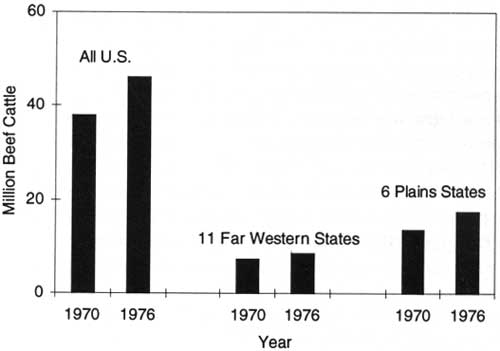
|
| Figure 21. Beef cattle numbers in the United States and its western regions, 1970-1976. Source: USDA Forest Service. |
Congress increased direct appropriations for national forest range management activities during the latter 1970's, and Forest Service range staffing rose from 640 FTE's between 1970 and 1976 to 900 FTE's by 1979. The annual levels of range improvement work, such as seeding, water development, and fencing rose to almost 300,000 acres by 1979, almost doubling the early 1970's level of 150,000 acres per year (USDA Forest Service 1992a).
It was under these circumstances, in 1972, that the Forest Service launched a major study of the potential of all range and related forest lands to meet the rising demand for range grazing while responding to the urgency for protecting the natural environment. Several other Federal agencies with rangeland responsibilities, including the BLM, and range researchers from the University of Nebraska became partners in this undertaking, called the Forest-Range Environment Study (FRES).
As a basic requirement for differentiating current conditions, management options, and potentials for environmentally acceptable expanded production, the initial step in FRES stratified all rangelands, nationally, into their separate "ecotypes" and ownerships. Subsequent analysis of each ecotype defined and assessed the different activities that could increase forage to meet projected future beef demands and at the same time protect the environment. Although beset with many data quality problems, FRES found that the Nation's rangelands, with proper range management and technology as well as environmental safeguards, could meet expected future grazing demands without detracting from other resource uses such as wildlife and aesthetics (USDA Forest Service 1974-1976). In 1974, five USDA agencies, including the Forest Service, presented an informational report for the Department of Agriculture's Policy and Program Division on management opportunities to increase domestic "red meat production," mainly beef. The study's second phase, on research and technology options, was completed in 1975.
In 1974, the Forest Service initiated its own planning and research to establish range evaluation and validation areas to test the validity of this management direction nationwide and to make possible adjustments to expand range and grazing production. The validation areas demonstrated alternative grazing systems for a variety of range conditions on dependent private lands as well as the related national forest and other public grazing lands. Unfortunately, these management demonstrations and strategies were never fully implemented and evaluated due to budget reductions in the early 1980's. Although the Forest Service completed limited evaluation on an Oregon validation area, others were discontinued in their early development. Beef demands peaked in 1976 and steadily declined due to consumer health concerns. Cattle inventories also declined with the falling demand, and the incentive to expand national grazing capacity and red meat production faded away after 1976.
Federal Land Policy and Management Act of 1976
The Federal Land Policy and Management Act of 1976 (FLPMA), as amended by the Public Rangeland Improvement Act of 1978 (PRIA), was enacted to regulate the public lands administered by BLM. The range management section of FLPMA, however, was written to apply to the national forest lands in Washington, Oregon, California, Nevada, Arizona, New Mexico, Utah, Idaho, Montana, Wyoming, Colorado, North Dakota, South Dakota, Kansas, Nebraska, and Oklahoma. In doing so, it set the stage for the Forest Service and BLM to continue their efforts for a more consistent approach to managing public rangelands. This Act reaffirmed existing national forest policy for administering and managing livestock grazing on national forests and clearly specified that national forest managers had broad discretional authority to modify the number of livestock permitted and to set limits on seasonal use of rangelands. It stressed once again that a grazing permit did not convey any rights to the permittee against the Government, but granted the permittee rights against other applicants. The 10-year term grazing permits were reaffirmed. The Act further provided that livestock grazing on national forest lands in the 16 contiguous western States be managed through the development of allotment management plans, which was the established national forest policy and management approach. It directed that the allotment plans be developed only after careful and considered consultation, cooperation, and coordination with permittees; other landowners, including States having land within the planning area; and others having interests in that area. It further specified that such plans prescribe how and to what extent livestock grazing practices, including range improvements, would be carried out to meet multiple-use sustained-yield objectives. These plans gave precedence to the resource and to meeting the objectives of new NFMA forest plans. Thus, where NFMA called for the removal of livestock grazing, the affected permits were phased out. When this occurred, FLPMA provided that permittees be compensated for range improvements they had installed based on their investment in the lost improvements.
FLPMA and subsequent regulations authorized the establishment of grazing advisory boards made up of grazing permittees elected by their peers. Most national forests had chartered such boards by December 31, 1985 — the date that the legislative authority for such boards expired. All boards were terminated when this legislative authority expired, and none were rechartered.
FLPMA also required that one-half of the grazing fees collected within the 16 contiguous western States be appropriated and made available for on-the-ground range rehabilitation. These monies were routinely appropriated by Congress and averaged approximately $4 million per year. However, such funds were not additional range funding because direct appropriations for range improvements were reduced by the same amount. National forest regulations earmarked these funds for rangeland betterment — seeding and reseeding, fence construction, weed control, water development, and fish and wildlife habitat improvement. To further the overall direction contained in forest plans, the Forest Service restricted the use of these funds to areas that had approved allotment management plans.
System-Wide Assessment of Range Condition
In 1977, the Forest Service completed a System-wide assessment of the ecological condition of rangelands based on their current vegetative cover and several soil factors. The current range condition (poor, fair, good, or excellent) was compared with what it would or should have been under pristine conditions. The pristine condition was used as the standard because it was believed to reflect natural conditions most favorable to long-term sustainability of range ecosystems. The ratings were qualitative on a continuum of low to intermediate and high, or of poor, fair, good, and excellent. The current ecological status of the existing plant community considered its composition, cover, and vigor in combination with such nonecological indicators as plant age classes and production. The assessment also evaluated the percent of soil ground cover and current soil erosion (Schmautz 1979).
The assessment found that 68 percent of the national forest rangelands were in satisfactory condition, 24 percent good or better, and 44 percent fair. The remaining 32 percent were classed as unsatisfactory. There were no previously established measures to assess the rangeland condition and trend based on the same criteria. The general judgment, however, based on a broad comparison with long-term historical conditions, was that overall trends were generally upward. Nevertheless, the hard facts remained that almost a third of the rangelands were in unsatisfactory condition, with a downward trend that needed to be halted and reversed to protect basic soil and vegetation resources.
In view of the long-term effort since the mid-1960's to improve range productivity and production, the level of unsatisfactory range conditions was unexpected. Range productivity efforts were out of balance with livestock management and the intensity, duration, and timing of grazing. The remedy to this situation was the improvement of livestock management practices — such actions as adjusting grazing seasons, changing permitted animal numbers, and implementing management practices that would lead to more productive and stable range conditions. In some instances, this meant less livestock and adjustments in elk, but in all cases it meant improved range management.
The Public Rangelands Improvement Act of 1978
The Public Rangelands Improvement Act (PRIA) was a national policy initiative that provided for the improvement of soil quality, wildlife habitat, watersheds, plant communities, and range condition on public rangelands. However, the portions of the Act relating to the national forests were amendments to FLPMA that required maintaining inventories of range conditions and trends and establishing an experimental stewardship program with incentives or awards for livestock permittees to improve range conditions on their national forest grazing allotments.
National forest managers, in cooperation with BLM, initiated the experimental stewardship programs (ESP's) on three areas in 1979 — one each in Idaho, Montana, and California. The BLM established 13 individual permittee stewardship areas scattered throughout Washington, Oregon, California, Nevada, Arizona, New Mexico, Utah, Idaho, Montana, Wyoming, and Colorado. The ESP purpose was to foster innovation, cooperation, and best range management practices to lead to improved conditions on the public rangelands. The innovative initiatives included cooperative resource management and fee collection distribution approaches, cash investments by permittees, and flexible animal numbers and length of season authorized by grazing permits. The major strength of the ESP was that local people conceived and developed the communications processes at the grassroots level rather than having them dictated by rule or policy from above. The ESP results, however, were never evaluated in terms of range condition improvement.
The Use and Performance of the National Forest Rangelands in the 1970's
The total number of cattle grazed annually on national forest allotments remained stable throughout the 1970's at about 1.3 million. The number of sheep grazed declined from 1.74 million to 1.17 million. The number of horses grazed declined slightly, from more than 175,000 per year to 170,000. Grazing by swine, largely in the South, declined from about 6,000 to negligible numbers as national forest managers increasingly prevented unauthorized use. Total and per animal forage consumption increased somewhat during this period, indicating some continuing weight gains for cattle grazed on national forest lands.
The number of commercial grazing permittees decreased by 13 percent during the 1970's, to a total of 15,518 by 1979. The number of allotments being maintained under intensive management practices increased from 4,600 in 1969 to 5,700 in 1979, a 24-percent improvement. The proportion of such allotments rose from 43 percent to 52 percent out of nearly 11,000 allotments. This trend supports the 1977 professional judgment and estimate that the trend in range condition was upward. However, it also indicated slow progress. Nevertheless, the improvement was notable in the light of the rising beef consumption and continuing pressure to expand grazing during the first seven years of the 1970's.
Soil and Water Resource Management
In response to NEPA requirements and the national goals of the Clean Water Act of 1972, soil and water management efforts greatly intensified during the 1970's. These efforts also responded to concerns emerging from the clearcutting issues and congressional hearings of the early 1970's. Federally approved State water quality standards were now required for all navigable waters on national forests. To ensure that water quality was being protected, national forests installed a water quality monitoring program to measure the effects of land use and management activities on water quality and quantity and the extent to which public water quality and supply goals were being met. At the end of the 1970's, the monitoring program was collecting and analyzing water samples from more than 5,000 locations. In 1978, the Forest Service estimated and reported that about 95 percent of the water produced by national forests was meeting minimum State water quality standards and that by 1985, national water quality goals for swimmable and fishable waters would be met (USDA Forest Service 1978-1980).
National forest resource managers and staff translated local water supply quality standards into performance limits and controls for land management activities such as managing and harvesting timber, managing grazing on rangelands, wildlife and fish habitat improvements, and fire preattack planning. The intensity of management and oversight of soil and water resources grew as the number of development projects receiving priority for soils, geologic, and hydrometric and water resource inventories rose. In 1969, the number of these projects was somewhat more than 500. In 1970, the number had risen to more than 1,000, and in 1971, to 2,000 (USDA Forest Service 1970-1972). Staffing for soil and water management inventories and services rose from less than 400 to 892 FTE's during the 1970's (USDA Forest Service 1992a).
National forest soil and water staffs conducted soil, geologic, and water resource inventories on 7 million acres in 1970 and 13.2 million acres in 1971 (fig. 22). In 1977, the acreage inventoried had risen to 15.8 million acres, and in 1979 to 18.1 million acres. Such inventories varied in intensity. Resource development projects usually required more detailed inventories, while less detailed inventories were generally suitable for broad land use planning purposes. Soil and geology inventories identified, classified, mapped, and evaluated landform, geology, vegetation, soil types, and climate associated with specific soils. These data helped identify soil and land capabilities for land use planning and project planning. Water resource inventories often covered the same ground. They classified and mapped watersheds and watershed subareas, grouping areas with similar characteristics, and predicted water yield and quality responses to particular uses and management.
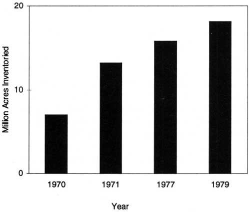
|
| Figure 22. Acres of soil, water, and geologic resources inventoried, selected years 1970-1979. Source: USDA Forest Service. |
Impact surveys conducted on water development projects on and adjacent to national forests and grasslands to provide national and local needs for power, irrigation, flood control, and other purposes reached their peak level (546 projects) in 1970. In 1971, they declined to 476 projects and dropped to even lower levels during the balance of the 1970's, as the rate of reservoir and dam construction declined generally in the United States.
Nevertheless, because public concerns for the environment and water quality were expanding, EA's and EIS's continued to determine the effects of reservoirs and other water resource developments on the protection, administration, and management of National Forest System lands, including the effects on national forest users and permittees, local economies, and the environments of rural communities. Survey reports recommended project plan improvements based on national forest management direction, and national forest managers implemented these improvements through coordination and cooperative liaison with water development agencies — an approach that produced direct environmental, economic, and social dividends. Treatment measures on national forest lands tributary to reservoirs and other water developments increased the quantity and quality of the water inflow to the reservoirs, improved scenic and other public use benefits, and, by reducing siltation, prolonged reservoir life. Other national forest water-related management that contributed to a safer and more attractive environment for reservoir users, and reduced maintenance costs, were sweeping and debris removal, access road and trail maintenance, and fire prevention and protection.
In 1976, FLPMA consolidated all water-related use-permitting authority to USDA and the Forest Service except the administration of permits issued before 1976. Administration of pre-1976 permits remained with the Department of the Interior. This permitting shift considerably increased the Forest Service s multiple-use management authority (Wilkinson and Anderson 1985).
National Forest Water Rights
Water rights issues and challenges escalated during the 1970's as national forest managers sought to ensure adequate water supplies for national forest uses such as recreation, instream flows, municipal needs, timber production, and national forest administration. Concerns over excessive appropriation of water from national forest water courses rose during the 1960's, as the use of water for irrigation and hydroelectric power generation intensified and began to degrade fish habitat and recreation sites.
The rising concerns led to a 6-year study, completed in 1972, on the long-term water needs for internal uses on western national forests and for local municipal water supplies. As the study was nearing completion, States were advised of national forest water use needs to aid in planning and developing their own water uses and potentially for accommodating national forest needs. The national forest policy since 1936 had been to obtain water rights in the name of the U.S. Government for national forest purposes in accordance with State law. Traditionally, the Congress had also deferred to State water law in water allocation matters. Typically, those rights were for consumptive uses. In the 1970's, however, national forest managers sought to justify water allocations for fish, wildlife, recreation, and aesthetic purposes on the basis of the Doctrine of Federally Reserved Water Rights on national forest lands reserved from the Public Domain. The Doctrine of Federally Reserved Rights was first enunciated in 1908 by the Supreme Court decision in Winter v. United States. The Court said that when the Federal Government established Indian reservations there was an implied reservation of water rights needed to achieve the purposes for which such Indian reservations were established. In 1963, the Supreme Court in the Arizona v. California decision expanded the "Winter Doctrine" to apply to other Federal reservations, including national forests.
Legal issues arose as to whether the Winter Doctrine actually applied to water rights for specific uses not cited in the Federal law and whether such reserved water rights could retroactively preempt private water rights established in previous decades under State law. In 1978, the Supreme Court narrowed the scope of the Winter Doctrine as it applied to national forest management purposes and uses. In United States v. New Mexico (the Rio Mimbres case), the Supreme Court interpreted the doctrine to mean that Congress intended to reserve only that amount of water necessary to meet the primary purposes for which national forests were reserved under the Organic Act of 1897 — to ensure a continuous supply of timber and to secure favorable water flow conditions. This ruling excluded the consideration of reserved rights for the use of water for purposes not explicitly in the Organic Act of 1897, such as fisheries, aesthetics, recreation, and stock watering (USDA Forest Service 1988). Thus, national forest managers' efforts to control the over appropriation of water by private individuals, industry, and communities by claiming reserved water rights met with only small success. In the main, they were unsuccessful. National forest water resource managers had to direct increased attention and effort to achieving desired and needed national forest water allocations under State laws (Wilkinson and Anderson 1985; USDA Forest Service 1972-1980).
Watershed Improvements
Watershed improvements benefitted water quality and increased water-holding capabilities of watersheds by controlling runoff, restoring soil productivity through the reduction of sheet and gully erosion, stabilizing soils and stream channels, and installing sediment retention structures. During the 1970's, an average of 35,400 acres of damaged watershed areas were treated each year. Actual acres treated annually varied from 16,100 in 1971 to 88,000 in 1978 and 36,000 in 1979. In 1979, the total national forest watershed area with declining watershed conditions and in need of improvement was reported to be 315,000 acres (USDA Forest Service 1972-1980).
Land treatments and watershed practices to prevent or control soil erosion constituted the vast majority of acres treated each year. Other treatments included several hundred miles of gully erosion control and soil stabilization, a few miles of lake shoreline improvement, revegetation and soil stabilization on 1,000 or more miles of abandoned roads and trails, and restoration of a few hundred acres of land disturbed by surface mining and prospecting.
Emergency rehabilitation of land damaged by wild fires and floods also contributed to watershed protection. The most extensive rehabilitation occurred on 375,000 acres of the total 446,000 acres burned by 25 major wildfires on national forest lands during the 1970's. Timely surveys of newly burned areas prompted such rehabilitation measures as improving road and trail drainage, clearing stream channels to rapidly improve the quality of large volumes of water, and aerial seeding to quickly establish ground cover on burned areas (USDA Forest Service 1972-1980).
Water yield improvement work on national forests in the early 1970's consisted principally of maintaining previously completed projects. National forests had applied water yield improvement practices on about 165,000 acres before 1970. Similar opportunities were estimated to occur on an additional 12.5 million acres within the national forests. The barometer watershed projects initiated in the 1960's to manage water yields were largely put on hold or retrenched during the 1970's in favor of higher priorities (USDA Forest Service 1972-1980).
Managing Wildlife and Fish Habitats and Use
The 1970's were a period of transformation and accelerating growth for wildlife and fishery management. It moved from what was largely seen as a secondary role in coordinating and adjusting other national forest resource activities and cooperative habitat improvement with States to a primary management function for protecting and improving wildlife and fish habitats, user opportunities, and the total quality of the forest environment. The pace of this transition was modest in the first half of the decade and then accelerated rapidly in the second half. As late as 1975, however, wildlife management was still seen as a distinct secondary, or even an incidental, function on most national forests and was still struggling for independent recognition (Robinson 1975; Wilkinson and Anderson 1985).
Total FTE staffing for wildlife and fisheries activities rose from less than 300 person years, including 100 biologists, in 1970 to 358 person-years in 1975. By 1979, however, total FTE staffing rose to 856 person-years and included several hundred biologists. Total direct Federal funding for wildlife and fisheries management and improvement rose similarly, from $13 million (constant 1992 dollars) in 1970 to $17 million in 1975 and then to more than $43 million in 1979 (USDA Forest Service 1992a).
The expanding role of wildlife and fish habitat management and improvement was primarily driven by new national policy and requirements for the environment and endangered species and related internal national forest needs for more effective integration of timber management and harvesting, livestock grazing, and mineral exploration and development with wildlife and fish management objectives.
Hunting and fishing use grew modestly from 29.0 million wildlife and fish user days (WFUD's) in 1970 to 32.1 million in 1979 (fig. 23). This was barely a 1-percent average annual increase — a major slowdown from the 3.5 percent per year growth rate in the late 1960's. It was also a much slower rate of increase than total RVD's, which grew at an average annual rate slightly greater than 3 percent during the 1970's. Nonconsumptive or appreciative uses of wildlife increased during the 1970's, but no reliable, consistent documentation was available except an estimate of "several million" WFUD's of total nonconsumptive use cited in the 1978 Annual Report of the Forest Service (USDA Forest Service 1979).
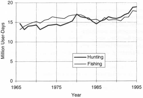
|
| Figure 23. Wildlife and fisheries user days (WFUD's) on national forests, 1966-1995. Source: USDA Forest Service. |
NEPA and the Endangered Species Act of 1973 (ESA) provided much stronger driving factors for intensifying wildlife and fish habitat management. NEPA requirements called for explicit assessment of the impacts of resource use activities on wildlife and fish with open, public participation. The ESA gave absolute precedence to the management of habitat to maintain or restore the viability of endangered wildlife, fish, and plant populations and indirectly called for action to protect sensitive and threatened species from becoming endangered. These policy objectives and requirements were reinforced by the public's demands and participation in resource planning. Wildlife and fishery public interest groups and individuals sought greater consideration for wildlife and fisheries and more emphasis on nongame species.
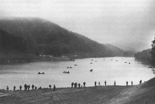
|
| Opening day of fishing season at Buffalo Lake Reservoir, Monongahela National Forest, West Virginia, 1971 (Forest Service Photo Collection, National Agricultural Library.) |
The adoption and implementation of the unit planning approach during the 1970's, with its intensified emphasis on zoning subareas to differentiate their multiple-use potentials and requirements, called for increasing consultation and integration of other resource uses with wildlife and fish habitat and use needs. There was no separate zoning for wildlife or fish. Wildlife occupied all zones and fish habitats were included in waterway and riparian zones. The stratification of the commercial forest lands into standard, special, marginal, and unregulated components further intensified the demand for wildlife and fish habitat management constraints and guidelines in planning and designing timber harvests. The maintenance of the general timber harvest level, while reducing clearcutting, expanded the demands for wildlife and fishery consultations and coordination. Less clearcutting meant that more acres had to be entered to harvest the same volume. In the early 1970's, this caused timber harvest entry into a half-million additional acres.
During the 1970's, and in the earlier decades, wildlife habitat management on national forests continued to be strongly linked with timber management. However, by 1970, wildlife managers were no longer generally accepting the former, widely held simplistic philosophy that "good silviculture also constituted good wildlife management." But it had become increasingly incumbent on wildlife managers to come up with guidelines and adjustments that could be readily applied and be reasonably economical for timber management and, at the same time, be effective in achieving wildlife habitat objectives. Large-scale wildlife management normally called for manipulation of tree cover, but this was usually too expensive to be done solely for wildlife purposes. Because forest management practices undertaken to increase wood production could introduce major changes in wildlife habitat conditions and structure, some wildlife managers began to view timber management as a practical way of achieving wildlife habitat objectives, provided the timber management activities were located, designed, and executed to also achieve them (Thomas 1979).
In the late 1960's, after the passage of the MUSY Act, wildlife managers had evolved two major approaches to wildlife management on national forests: species richness and featured species. Both followed the basic ecological principles developed by Leopold and other conservationists in the 1930's and focused management strategies and practices on achieving habitat diversity to encourage and maintain species richness for local areas as well as for broader ecosystems (Wilkinson and Anderson 1985).
Species Richness Approach
The species richness approach provided or maintained the habitat requirements for a wide variety of species by using practices ranging from clearcutting to provide big game forage and edge effects to protecting old-growth forests to maintain cover. A specific prescription was required for each land unit that would create and maintain habitat conditions and structures that would sustain wildlife species and populations at a level that would preclude their extirpation (total loss in the areas they occupied). Although wildlife managers sometimes focused on a particular species in applying the species richness approach, they usually did not set standards for any particular species.
Featured Species Approach
The featured species approach was implicit in early efforts to protect endangered species such as the condor in California, the Kirtland's warbler in northern Michigan, and the osprey in central Oregon. This approach was particularly well adapted to address endangered species, but it raised various difficulties when it was applied to other species. Focusing on a particular species involved difficult-to-evaluate tradeoffs with other species, especially where the featured species was not endangered. Timber managers would adjust harvests for endangered species, but were reluctant to do so for a secondary featured species if it involved unduly complicated timber management adjustments beyond those required for a primary featured species (Wilkinson and Anderson 1985).
The featured species approach was first developed as a general approach to wildlife management on the southern national forests. Southern wildlife user interests focused their attention on particular animals, whether for hunting, as in the case of deer and squirrels, or because they were endangered, such as the red-cockaded woodpecker. For this reason, the Southern Region focused its wildlife management approach on developing a handbook for managing the region's principal species. The Featured Species Handbook, published in 1971, was prepared with the collaboration of timber managers, research scientists, and wildlife specialists and became the region's basic reference guide (Roth 1988).
The handbook's primary guideline provided that all silvicultural activities be carried out to promote the featured species and, indirectly, such other species that had the same habitat requirements. Where deer were the featured species, for example, timber would be harvested in broken clearcuts, leaving some early successional tree species on the site. Where squirrels were the featured species, some hardwoods would be left on the sale area. Where management focused on protecting the endangered red-cockaded woodpecker, trees left on the sale area provided for their favored nesting sites — tree hollows in older growth southern pine trees with red heartwood. Biological diversity was achieved by varying the wildlife featured species selection among adjacent management areas, which ranged from 2,000 to 10,000 acres in extent. State wildlife commissions and management agencies participated directly in selecting featured species. In practice, nongame species other than endangered species were usually not featured species, although they were mentioned in the Featured Species Handbook. The effects of the featured species management system were far-reaching for both wildlife and timber management (Roth 1988).
Ned Fritz, a Texas attorney and an active critic of national forest timber harvesting, filed suit against the Forest Service over the featured species management system. He charged that it was not based on proven biological principles and that it was detrimental to threatened or endangered species such as the red-cockaded woodpecker. The Federal District Court in Tyler, Texas, in 1976, however, upheld the system's biological soundness. It also found that featured species did not violate the ESA — marking the first time that a Federal agency prevailed in an endangered species test case (Roth 1988).
Managing Wildlife Habitats in Managed Forests: An Integrated System
In 1977, national forest wildlife managers and scientists documented a general methodology for evaluating the possible influence of various timber management practices on the habitats of the many wildlife species that occupied large managed forested areas (USDA Forest Service 1978). This methodology provided forest managers an insightful, systematic way to integrate timber management with many wildlife species' habitat requirements. It quickly became a widely used tool for preparing land management plans, assessing wildlife habitat impacts for EIS's, and integrating wildlife habitat requirements with timber management on the ground.
This methodology, initially developed for integrating timber management with wildlife requirements in the Blue Mountains of eastern Oregon and southeast Washington, was published in 1979 as USDA Agricultural Handbook No. 553, Wildlife Habitats in Managed Forests: The Blue Mountains of Oregon and Washington. The actual project and handbook, respectively, were coordinated and edited by Jack Ward Thomas (1979), when he was the principal research biologist and project leader at the Pacific Northwest Forest and Range Experiment Station in LaGrande, Oregon. Thomas, in late 1993, was to be named the thirteenth Chief of the Forest Service.
The handbook had 16 authors, including Thomas. They included experts in wildlife biology, silviculture, fish and wildlife habitat management, range and plant ecology, landscape management, resources and environmental planning, game management, riparian areas, and forest fuels and fire management. Forty-five other natural resource professionals and scientists contributed substantive materials that were incorporated into the handbook's content. The effort became serendipitous as the authors and contributors multiplied, data and information accumulated, and the systematic relationships and methodology evolved. The final document included 10 chapters on basic relationships and methodology for integrating wildlife habitat requirements for numerous species with timber management and the timber types (mainly ponderosa, lodgepole pine and mixed conifer) in the Blue Mountains, which embraced a total of 5.5 million acres of CFL, 72 percent of which was included in four national forests: the Malheur, the Ochoco, the Umatilla, and the Wallowa-Whitman. In addition, the Blue Mountain Guide, as it became known, included 59 appendixes documenting the available, underlying resource data and relationships and over 400 annotated references.
This monumental work was an immediate success. Other national forest regions quickly adopted its basic approach and used it as a model, with modifications, for systematically integrating wildlife habitat requirements with timber management for their own locally managed forest areas and conditions. The underlying methodology that "good timber management can be good wildlife management if it is done correctly" was a modified version of the old cliche' that "good timber management is also good wildlife management." The new methodology essentially embodied a modern ecosystem approach to managing multiple uses and became an important tool for fulfilling the goal of "good wildlife management." It was specifically designed for large-scale wildlife management, where manipulating the tree cover solely for wildlife on large forest areas was either too expensive or too extensive. The new methodology provided an effective tool for wildlife biologists to coordinate with timber managers to provide and maintain habitats for many wildlife species, including selected featured species. Because the new methodology developed for the Blue Mountains forests addressed nongame species requirements, it also became instrumental in shifting the National Forest System's emphasis from its traditional orientation toward game species more strongly toward endangered, threatened, and nongame species (Roth 1988).
The Blue Mountains methodology had its origins in the severe Douglas-fir tussock moth outbreak in Oregon, Washington, and Idaho in 1974. In the winter of 1975, the forest supervisor of Oregon's Umatilla National Forest sought out Jack Ward Thomas for advice about wildlife before he harvested trees killed or injured by the tussock moth (Roth 1988). The forest supervisor made it abundantly clear that he would soon harvest the trees whether he got the advice or not. Working under this indeterminate, but urgent, deadline, Thomas came up with initial guidelines within 3 weeks. Surprised by this prompt response, the supervisor then wanted to know, "if you can do this in 3 weeks, what more can you do?" Thomas, who at that time was national president of the Wildlife Society (which had lobbied for the wildlife sections of NFMA enacted in October 1976), saw the supervisor's query as the opportunity to implement NFMA's wildlife provisions for nongame species. Although there was no authorization for doing such a project, he undertook it on his own initiative. This was the beginning of the Blue Mountain Guide. It soon had the support of the forest supervisors on the four Blue Mountain national forests, who saw its utility and the need for such a tool and gave direction and encouragement to carry out the task (Thomas 1979). The BLM provided additional financial resources for completing the guide, and the director of the Pacific Northwest Forest and Range Experiment Station encouraged its completion and publication so that others could use this fully developed wildlife evaluation system.
The Blue Mountains methodology grouped 378 species of amphibians, reptiles, birds, and mammals into 16 lifeforms based on the similarity and closely related habitat requirements of each group. The basic objective in evaluating alternative timber management strategies and practices became the maintenance of habitat diversity. The evaluation model was based on the relationship between lifeform feeding and reproduction habitat requirements and the plant community or vegetative type (meadow, sagebrush, juniper, aspen, ponderosa pine, or subalpine fir) and the successional stage of the plant community (grass-forb, shrub-seedling, sapling-pole, young, mature, or old-growth). These relationships were also developed for individual wildlife species. The methodology analyzed and summarized available biological data and bibliographies on the habitat relationships of each species and evaluated the critical role of special habitats such as riparian zones, edges, snags, and logs and unique habitats in geomorphic formations such as cliffs, caves, and talus. The underlying management and decisionmaking principle was that maintaining habitat diversity was the key to restoring the variety of wildlife species to the Blue Mountains ecosystem.
The initial highly specific guidelines prepared for wildlife habitat protection in a timber salvage program planned for the Blue Mountains national forests evolved into a generalized methodology for evaluating the impact of timber management alternatives on wildlife. The general guidelines emerged as a direct consequence of critiques by national forest managers who began to use the initial specific guidelines. They were adamant about one point — the specific guidelines were too rigid. In order apply them to local situations, the guidelines needed to be more flexible. Using the more generalized guidelines, national forest managers could evaluate alternatives, make appropriate tradeoffs, and account for those decisions.
Support for and Coordination With Other Resource Activities
Based on staffing and funding levels during the 1970's, support and coordination activities, including management for threatened and endangered species, constituted about two-thirds of the wildlife and fish habitat management effort and tripled between 1969 and 1979. In 1969, about 180 FTE person-years were devoted to support and coordination activities. Most of the huge increase came after 1975, when FTE person-years were only 235 compared to 530 in 1979 (USDA Forest Service 1992a).
ESA's enactment in 1973, the Sikes Act Extension in 1974, and NFMA in 1976, together with major funding increases that came in 1978 — a direct result of goals and funding levels proposed by the 1975 RPA program — all contributed to the expansion of the wildlife and fish habitat support and coordination function. The Sikes Act Extension exercised its influence through its mandate that the Secretaries of Agriculture and the Interior "work in concert with the States to develop comprehensive plans . . . for the conservation and rehabilitation of wildlife, fish, and game." Roth (1988) cited the Sikes Act Extension and NFMA as "the cornerstones" of modern wildlife management on national forests.
In the late 1960's, wildlife biologists began to advocate retention of some "snags" and dead trees which, at that time, were routinely felled to reduce the potential hazards they posed to loggers and as wildfire ignition. These efforts, however, remained largely unsuccessful until the late 1970's when leaving snags and dead trees for birds and providing other wildlife-related treatments became more general practices (Roth 1988). The number and sizes of snags needed, as well as patch sizes or the need for individual, well-spaced snags, became hot topics for wildlife biologists, timber planners, and managers and were complicated by the Department of Labor Occupational Safety and Health Administration (OSHA) standards which essentially required that dead snags be cut for worker safety.
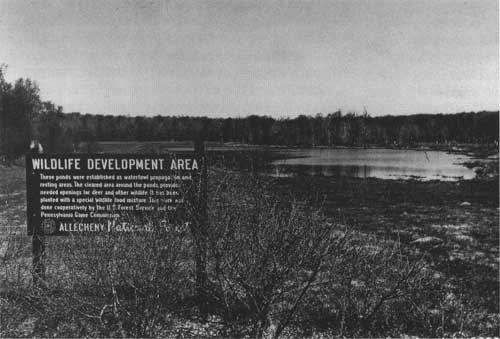
|
| Area clearcut around pond and planted with special mixture of plants to improve habitat and food for deer and other wildlife, Allegheny National Forest, Pennsylvania. Pond was established as waterfowl propagation and resting area. (Forest Service Photo Collection, National Agricultural Library.) |
In the Pacific Northwest, before the 1970's, there was little coordination of grazing and riparian area protection for wildlife purposes. As research in the middle 1970's showed that fish populations decreased approximately 50 percent if livestock were grazed next to streams, range conservationists began to increase their efforts in the late 1970's to keep livestock away from streams and to expand the use of alternative stock watering systems (Roth 1988).
Following NFMA's passage in 1976 and the availability of the Blue Mountains Guide for integrating habitat requirements of all wildlife and fish species with timber management, the habitat requirements of nongame wildlife became more important. Coordination included modifying timber sales to protect the nests of hawks, owls, and other raptors and installing direct habitat improvements such as nest structures for songbirds, hawks, and geese. NFMA also expanded the Forest Service's authority to use KV funds (a percentage of timber harvest receipts retained for resource management) for wildlife and fish habitat management. This authorization provided an increased opportunity to improve big game habitat productivity, fisheries potentials, and other wildlife habitats on national forests (USDA Forest Service 1978).
A Case in Point: Coordinating Timber Management and Elk
In 1970, the elk and timber management issue in Montana's Little Belt Mountains led directly to a cooperative agreement for conducting research on the effects of logging and roads on Rocky Mountain elk. The cooperators initially included the National Forest System's Northern Region; the Intermountain Forest and Range Experiment Station; the Montana Department of Fish, Wildlife, and Parks; and the University of Montana's School of Forestry. The BLM joined the agreement in 1971. The Plum Creek Timber Co., Inc., a major timber landowner of the former Northern Pacific railroad grant lands, became a participant, but not a cooperator, in 1974. It had a representative at all research committee meetings and, after 1980, provided financial support. The study objectives were to determine certain ecological requirements of elk and the effects of logging, roads, and access on elk populations in order to develop guidelines that would ensure maximum compatibility between timber harvest practices and elk management.
The research was initially planned for 5 years, but it was extended twice, each time for an additional 5 years. Eight major study areas were established in the first half of the 1970's to represent the various cover types on five national forests in Montana (the Lolo, the Bitterroot, the Beaverhead, the Flathead, and the Lewis and Clark) and the BLM Garnet Resource Area (throughout western and central Montana) to conduct the various intensive and extensive studies. Eighty-seven clearcuts of various ages were selected throughout the heavy timber stands and the open timber types of western and central Montana to study elk use of various-aged clearcuts on summer ranges. In addition, in 1980 and 1981, eight evaluation areas in Montana and three in northern Idaho, averaging 25 miles square and divided into 3 or 4 subunits, were selected to analyze cover, forage, and road density relationships that influenced elks' use of their habitat. Beginning in 1974, the research produced a series of recommendations for designing and conducting timber sales to minimize their adverse effects on elk. These recommendations were implemented as they emerged. As the research advanced for another decade, feedback from the results obtained in the early actual management applications often modified and clarified the initial recommendations.
South Fork Salmon River Strategy
In 1964 and 1965, on Idaho's Payette and Boise National Forests, heavy rain on snow resulted in massive sedimentation of the South Fork of the Salmon River. A logging moratorium and erosion control efforts began immediately to contain any further erosion and sedimentation and encourage stream flushing. The 1970's rehabilitation effort focused on reducing the landslide potential of logging roads on steep slopes. Logging-road closures continued. Revegetation and drainage system improvements on main roads also continued. By 1975, erosion control measures and the natural stream flushing action had greatly reduced the amount of sediment in the South Fork and its tributaries. In 1974, hatchery summer Chinook smolt were released by Idaho's Fish and Game Department, and by the end of the 1970's adult summer Chinook were being trapped to spawn for hatchery operations.
In 1977, the improving trend in salmon habitat conditions led to the resumption of timber harvesting on the upper South Fork drainage. The management plan for the area identified anadromous fish as its most valuable resource. It also made all land-disturbing activities conditional upon the continued improvement of fish habitat. The Chief of the Forest Service established a group of scientists known as the South Fork Salmon River Monitoring Committee to ensure annual independent reviews of sediment management results. Several years later, in 1983, these reviews found that sedimentation had not declined and that fish habitats had not improved since timber harvesting had resumed in 1977. These findings resulted in a new moratorium on timber sales in the Upper South Fork drainage. The South Fork salmon habitat rehabilitation efforts have been continued to the present. In the 1990's, they became a part of the Columbia River Basin Salmon Management Project to restore the populations and habitats of several salmon species whose populations have been seriously depleted and where habitats have been degraded by a number of different influences ranging from the overharvesting of fish and water power developments to sedimentation and severe drought.
Endangered Species Management
A 1972 survey, entitled "Present Status and Needs of Habitat Maintenance and Improvement for Rare and Endangered Species on Forest Service Administered Land," found that 39 of 109 listed endangered species in the United States were on or near national forest lands. Some were already the subject of management efforts to improve their habitats in ways that would halt further deterioration of their populations and help their recovery. In 1974, to comply with ESA, the Forest Service developed a comprehensive 5-year program to address the needs of all 39 of the listed species. Sixteen additional domestic species that were rare or otherwise considered sensitive were also included in the program (USDA Forest Service 1974, 1975).
The early efforts emphasized inventories and surveys essential to locating endangered and threatened species. In 1975, for example, special efforts were made to locate bald eagle nesting sites, mainly in Florida, Arizona, California, Wisconsin, and Alaska. Several new research units were set up to assist in conserving endangered and threatened wildlife. One unit, working in cooperation with South Carolina's Clemson University, began studying the red-cockaded woodpecker and Backman's warbler. Research on other selected endangered species was initiated in Arizona and Hawaii (USDA Forest Service 1976).
In 1977, habitat improvement efforts and management guidelines were in effect for the California condor, southern bald eagle, red-cockaded woodpecker, Mississippi sandhill crane, American peregrine falcon, and blunt-nosed leopard lizard, and for other species. Comprehensive management efforts were evolving in cooperation and consultation with the U.S. Fish and Wildlife Service and the States. For example, studies to determine the habitat requirements for, distribution of, and future management direction for grizzly bear populations were expanded in Montana and Wyoming. Study results were expected to directly benefit the estimated 800 surviving bears and provide the needed management direction to ensure the perpetuation of the species and its populations (USDA Forest Service 1978-1979). Continuing surveys broadened the species base for the endangered and threatened species management effort. By 1977, the surveys reported that more than 60 threatened species had been found and identified on national forest lands (USDA Forest Service 1978).
Habitat Improvement Activities
The installation of wildlife food and cover improvements expanded greatly during the 1970's, from 186,000 acres in 1970 to about 250,000 acres in 1974. Thereafter, actual land treatment for wildlife food and cover benefits accelerated to 950,000 acres per year by 1979 (fig. 24). Acreage treated accelerated even more than the funding and staffing, reflecting the growing integration of wildlife practices with other land treatments for silvicultural, fuel management, and wildfire control purposes, and greater coordination efforts among managers and staff experts in all resource areas. Such integration was most extensive where prescribed burning was the basic tool, whether it was used primarily for silvicultural, fuel management, fire control, or wildlife purposes. Similar integration occurred on reforestation projects where wildlife food planting was integrated with reforestation.
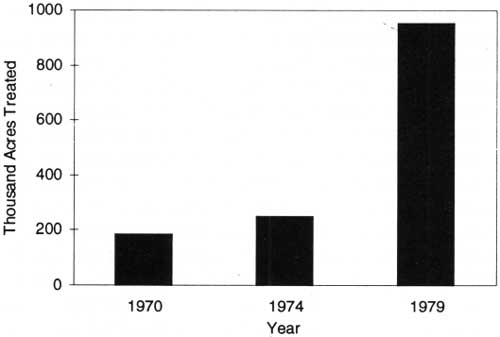
|
| Figure 24. National forest area treated to provide wildlife food and cover benefits in 1970, 1974, and 1979. Source: USDA Forest Service. |
In the early 1970's, before 1975, seeding, planting, and release of forage plants, the predominant land management treatments for wildlife, averaged about 120,000 acres per year. Prescribed burning for wildlife habitat improvement remained below 100,000 acres per year. Treatments to protect key wildlife areas varied between 3,000 acres and 12,000 acres per year. Treatments to improve the wetland habitat for waterfowl, for example, varied between 3,000 and 7,000 acres per year. All of these practices increased significantly during the last half of the 1970's, with the largest expansion coming in the use of prescribed burning specifically for wildlife habitat improvement.
The foregoing wildlife treatment acreage data related only to the actual acres treated directly for wildlife. However, the total acreage of wildlife habitat benefitting from such treatments was four or five times greater. Total benefitting acreage in 1970 would have been about a million acres compared to approximately 4 million acres in 1979. Prescribed burning was the treatment making the greatest contribution to this multiplication of benefits. Small water developments such as ponds, troughs, guzzlers, and other wildlife water supply improvements were regularly installed at the rate of about 1,000 a year. Wildlife habitat acres benefitting per improvement averaged about 180 acres per installation.

|
| Wildlife habitat improvement, Ocala National Forest, Florida. Instructor and Florida YCC campers installing a wood-duck nesting box on a tree beside the St. Johns River, 1971. (Forest Service Photo Collection, National Agricultural Library. Taken by Freeman Helm.) |
Direct habitat improvements for stream and lake fisheries were far less extensive than those for wildlife. This was largely a function of the relatively small acreage of national forest lands occupied by fishable waters. Their management was equally important for protecting and maintaining environmental and water quality on the national forests and for ensuring more satisfying recreational and commercial fishing opportunities where they were practicable. The total visitor use of fishing opportunities on national forests in the 1970's exceeded those for hunting, indicating far more intensive use of the more limited fisheries habitats and opportunities. In 1978, anadromous fish produced annually from national forests provided for an annual catch of 28 million salmon weighing 118 million pounds and valued at an estimated $100 million (USDA Forest Service 1979).
Not included in the foregoing fish habitat treatments and improvements were the land management and treatment activities designed to protect watersheds and riparian areas and remedy soil and water resource problems when they occurred as a result of either management activities or natural phenomenon. These efforts likewise contributed to the protection and maintenance of water flows and water quality as well as to fish habitats. They are difficult to summarize here and are covered in the discussions of other resource activities.
Fish stream and lake improvements were measured regularly from 1975 to 1979 in terms of acres benefitting from various treatments. Total waters benefitted in those years were 87,100 acres, with an average annual level of 12,400 acres. Actual annual benefitting waters varied from 4,700 acres in 1977 to a record level of 24,000 acres in 1979. Stream improvements included channel structures and stabilization treatments, stream barrier removals, spawning bed improvements, and the establishment of new fishing reservoirs and lakes. Fish population control consisted mainly of the removal of rough and undesirable fish from both streams and lakes.
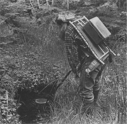
|
| Tongass National forest, Alaska, biological technician using electroshocker to survey feeder stream for salmon, which often rear in the upper reaches of drainages. The electric shock immobilizes fish long enough to identify them and make notes. (Forest Service Photo Collection, National Agricultural Library. Taken by Walt Mott.) |
State Cooperation
State cooperation with national forests was a major component of the wildlife and fish habitat support and coordination function, and States continued to finance about half of the direct habitat improvement work as part of their continuing cooperative projects. State priorities, which had leaned heavily toward game and sportfish during the previous decades, largely continued to govern management of wildlife and fish habitats. National forest managers continued to heed the traditional policy view that the States had the jurisdiction and responsibility for managing wildlife and fish populations as well as setting hunting or fishing regulations on the national forests. National forest managers, however, had the clear responsibility for managing the forest and range vegetation and habitats for multiple-use purposes, including wildlife and fishery habitats.
In 1970, the Public Land Law Review Commission (PLLRC) recommended that formal cooperative agreements be used to coordinate Federal and State wildlife programs (Wilkinson and Anderson 1985). This recommendation was enacted into the Sikes Act Extension of 1974 mandating the preparation of "comprehensive" plans in cooperation with the States for the conservation and rehabilitation of wildlife, fish, and game. Such jointly developed comprehensive national forest fish and wildlife plans were prepared cooperatively in 35 States during the late 1970's (USDA Forest Service 1978). These plans included provisions for range rehabilitation, ORV control, endangered or threatened species protection, and other terms and conditions that national forest managers and State officials deemed "necessary and appropriate" (Wilkinson and Anderson 1985).
NFMA reinforced the Sikes Act Extension by mandating State and Federal coordination on national forest land management planning. NFMA regulations required such coordination with State fish and wildlife agency biologists. NFMA and the Sikes Act Extension also required, "where appropriate," that national forests adopt State-identified threatened or endangered species as "indicator species" for wildlife and fisheries (Wilkinson and Anderson 1985). In 1978, the cooperative efforts between national forest managers and State fish and wildlife agencies led to the development of the first general guidelines to protect habitats for such nongame species as woodpeckers and the northern spotted owl. In the 1980's, the northern spotted owl would become the object of major Federal court suits and policy issues relating to the national forest's management of endangered species and old-growth forests. In the 1970's, the spotted owl had not been federally listed as an endangered species, nor had the State of Washington classified the owl as "sensitive," nor had the State of Oregon listed it as "threatened." These actions were still to come in the 1980's (Wilkinson and Anderson 1985).
Wildlife Management Institute Study
In 1978, about the time that fish and wildlife management was beginning its major expansion on national forests, the Forest Service contracted the Wildlife Management Institute (WMI) to study the national forest fish and wildlife program. WMI researchers interviewed some 900 Forest Service employees in the Intermountain, Pacific Northwest, and Southern Regions. Since many of the interviewees had worked in other regions, the study leaders felt their results were reasonably applicable to the entire National Forest System. The WMI researchers found that there were managed forests with well-conceived wildlife plans, but that there was a general lack of firm and consistent direction from the Forest Service's Washington Office. They saw a need for national objectives to strengthen "the position of administrators interested in wildlife and fish, and place requirements on those who are not so inclined" (Roth 1988). They also reported that many of the national forest comprehensive fish and wildlife plans provided under the Sikes Act Extension of 1974 were deficient in inventory data and did not identify research needs, and that a majority of the interviewees lacked any awareness of or had not read the Sikes Act plan for their particular forests (Roth 1988).
Wildlife and Fish Population Status and Trends
Summary data on national forest wildlife and fish population trends were very limited, except for big game. Generally, however, the shift of national forest wildlife and fish management away from the dominant focus on big game toward maintaining species richness clearly pointed to stronger efforts to sustain habitat diversity and improve the viability of fish and wildlife populations. A new threatened and endangered species policy provided for management actions to reinforce and restore the viability of species populations that were endangered. During the 1970's, no species losses were identified or reported for national forest lands.
Big game populations were generally maintained or increased during the 1970's (see fig. 9, chapter 3). The principal exceptions were deer and mountain goats. Mule and black-tailed deer populations were at peak levels on national forests in 1970, numbering about 2.8 million. However, mule deer population collapses in the Pacific Northwest, together with State and national forest efforts elsewhere during the 1960's to reduce deer herds to manageable sizes, contributed to a major decline, to about 1.9 million deer, by 1980. White-tailed deer populations at a peak level of 900,000 in 1960 had declined during the 1960's and continued to decline to less than 800,000 by 1980. Total deer legally harvested on the national forests declined from 493,000 in 1970 to a low of 312,000 in 1976 and then rose to 360,000, or 13 percent of their total population, by the end of the decade. Elk numbers continued to increase steadily during the 1970's, from 360,000 in 1970 to 470,000 in 1980, compared to 300,000 in 1960. The number harvested in each year during the 1970's averaged about 75,000, or 18 percent of the total.
Other big game populations — pronghorn, black bear, moose, caribou, bighorn sheep, turkey, and mountain lion — increased during 1970's. Dall sheep remained stable. Only mountain goats decreased, from 31,000 to 23,000. Thus, big game generally appeared to have fared fairly well under the cooperative management arrangements worked out between national forest wildlife managers and State game officials.
No data are available on fish populations. However, national forests in the Pacific Northwest and Alaska, which had more than 10,000 miles of streams that constituted "nursing waters" for the Pacific salmon, estimated that they produced an annual catch of 28 million salmon, weighing 118 million pounds (USDA Forest Service 1972, 1978-79).
Population trends for small game — rabbits, hares, squirrels, quail, pheasant, forest grouse, prairie grouse, doves, and woodcocks — are not available for national forests. However, the national forest share of small game hunting tags indicates that national forests provided from less than 5 percent to 15 percent of all small game hunting days in each national forest region. In some regions for individual species it ranged from 20 to 70 percent — for example: 40 to 70 percent for forest grouse in the Southern, Rocky Mountain and Pacific Coast Regions; 25 percent for waterfowl in the interior West; and for squirrels, 40 percent in the Rocky Mountains and 20 percent in the South (USDA Forest Service 1982).
National Forest Land and Resource Management Performance in the 1970's
For national forest managers, the 1970's were marked by a continuous effort to upgrade the integrated management of multiple uses on national forest lands everywhere in ways that improved both total resource productivity and the quality of the forest environment. These challenges were all the greater as the demands for timber and range resources remained at high levels and national forest resource use and the American public's interest in recreation, wildlife and fisheries, wilderness, minerals, and water expanded significantly.
The record of national forest planning and on-the-ground management activities reveals a growing effort and commitment to integrating the management of multiple uses more effectively on the land — a trend generally consistent with improving ecosystem viability and integrity and the quality of the environment while satisfying timber, range, mineral, and energy resource production objectives. The trend also seems to have responded to the ecosystem management training efforts initiated in the early 1970's and continued through the decade. Nevertheless, at the end of the 1970's, much more remained to be done.
Changes in resource allocation, management, and on-the-ground conditions came perceptibly, but slowly, during the 1970's for several good reasons. Only a very small percentage of the total forest lands could be treated through management activities in any one year. This was a function of both the funding and the long-term nature of forest resource production, use, and management.
The science and technology for change were limited, and new management approaches, as they emerged, took time to introduce into the huge national forest management system and its organization. Thousands of professionals needed to be trained in the new approaches or needed to update their skills and capabilities to meet new goals and objectives. Often, the prime need to bring about desired management changes called for new data and knowledge and new technology. Thus, research frequently became the principal route to finding new management approaches. Scientific studies to develop the new data, knowledge, and technology to successfully implement new approaches often involved several years to a decade or longer.
Change was also hampered by national policy objectives and programs for benefitting the Nation's economy, national housing goals, mineral and energy supplies, and Federal rangeland use. Production and management demands competed for the time needed by national forest managers and experts for training and updating technology. On the other hand, new national policy and program initiatives for the environment, wilderness, wildlife, fisheries, recreation, water quality, and cultural resources became driving forces that brought desirable improvements to national forest management. Often, the Forest Service was among the supporters of and, in some instances, a leading advocate for such improvements.
Implications for the 1980's and 1990's
Jack Ward Thomas's basic methodology for integrating wildlife and fisheries objectives with timber salvage among the various ecosystems of the Blue Mountains laid the basis for a more universal approach to integrating biodiversity and sustainability objectives more effectively into the management of multiple uses within ecosystems. Because the generalized Blue Mountains model avoided rigid or specific guidelines and focused on evaluating management alternatives for multiple uses within ecosystem capabilities on a sustainable basis, it found prompt and wide acceptance among national forest managers as an appropriate tool for resource planning and management decisionmaking.
Thomas's model, however, also revealed that while it was possible to evaluate alternatives for managing multiple uses with the many ecosystem variations, there were enormous data shortcomings and knowledge gaps about resource relationships and ecosystem responses to management. Decisionmaking called for considerable reliance on judgment, experience, and expert advice and often left substantial uncertainty about the ultimate long-term outcome of management. These limitations led to identifying priorities for gathering new data, conducting new research on resource relationships, and monitoring ecosystem responses to management decisions.
National forest management performance during the 1970's clearly revealed that the Forest Service professional staff and scientific researchers had both the understanding and commitment to manage national forest resources, uses, and ecosystems in response to established policy goals and program objectives. The basic grounding and experience in resource management principles and ecosystem management theory existed within the National Forest System and Forest Service Research to do so in ways that benefitted environmental quality and ecosystem sustainability; however, many of those skills and capabilities varied from district to district, forest to forest, and among regions. Nevertheless, the decade of the 1970's also demonstrated that it was difficult to marshal these skills and capabilities rapidly, uniformly, and effectively within the huge National Forest System. With its decentralized operational organization and stratified hierarchical leadership in a period of major shifts of public interests and policy priorities, the Forest Service needed strong, clear national policy guidance from the Executive Branch and the Congress to address the new goals and objectives along with consistent changes in program targets and supporting budgets.
While national forest managers could participate and sometimes play a leading role in policy issues and the development of new policy goals, programs, and budgets, their primary role was to implement the specific policy and programs provided by the Nation's policymakers. However, implementing such policy goals and programs and budgets often became a hapless, if not hopeless, dilemma in many management situations increasingly burdened by oversight of public interest groups and their recourse to appeals and court suits to achieve their policy preferences and the letter of the law for their management expectations. These interventions became increasingly strong driving forces for change within the National Forest System, especially during the 1980's. National forest management on the ground generally moved toward greater environmental sensitivity, more effective integration of multiple uses, a broader ecosystem approach to planning and management of multiple uses and a stronger balance of amenity uses with commodity uses, however unevenly that management came among the ranger districts, national forests, and regions of the National Forest System.
References
Bailey, Robert G. 1983. "Delineation of Ecosystem Regions." Environmental Management 7:4:365-373.
Bailey, Robert G. 1987a. "Suggested Hierarchy of Criteria for Multi-scale Ecosystem Mapping." Landscape and Urban Planning 14:313-319.
Bailey, Robert G. 1987b. Mapping Ecoregions to Manage Land. 1987 Yearbook of Agriculture. Superintendent of Documents, Washington, DC. pp. 81-87.
Barr, Frankie. 1996. Direct communication, February 8, 1996. Administrative Director, National Ski Patrol, and School Coordinator for the National Avalanche Foundation, Lakewood, CO.
Bartlett, E.T. 1994. Oral communication, December 7, 1994, and December 15, 1994. Instructor of Ecosystem Management Short Course, Department of Range Science, Colorado State University, Fort Collins, CO.
Benedict, Warren V. 1981. History of White Pine Blister Rust Control — A Personal Account. USDA Forest Service, Washington, DC. 47 pp.
Burch, Frank. 1995. Review notes for John Fedkiw dated 10/23/95. Division of Timber Management, USDA Forest Service, Washington Office, Washington, DC.
Cliff, Edward P. 1971a. "The Forest Service in the 1970's." American Forests, Volume 77: No. 1. January 1971. Reprinted from interoffice memorandum circulated to Forest Service employees in October 1970.
Cliff, Edward R 1971b. "The Multiple Use Concept in Public Land Management." Presentation to combined meeting of Western Association of State Game and Fish Commissioners and the Association of Midwest Fish and Game Commissioners, Aspen, CO, July 20, 1971.
Coghlan, Gerald. 1995. Direct communication. Review comments dated January 3, 1995. Engineering Staff, Washington Office, USDA Forest Service, Washington, DC.
Colorado State University. Undated. Ecosystem Management Short Course. Compilation of papers by 17 authors on ecosystem topics. Sponsored by the USDA Forest Service and the Range Science Department of Colorado State University, Fort Collins, CO. 114 pp.
Cook, Wayne. 1994. Oral communication, December 7, 1994. Organizer (retired) of the Ecosystem Management Short Course at Colorado State University, Fort Collins, CO, in 1968.
Fedkiw, John. 1985. "Some Questions and Implications for Range Management Based on the Demand Outlook for Red Meat and Range Grazing." Rangelands 7(3):100-104.
Fowler, Richard F. 1993. Direct communication, June 13, 1996. Forest Pest Management, State and Private Forestry, USDA Forest Service, Washington, DC.
Fowler, Richard F. 1993. Personal correspondence to author, dated 6/11/93, with comments from David E. Ketcham, Director for Environmental Quality. Forest Pest Management, USDA Forest Service, Washington, DC.
Fowler, Richard F., L.F. Wilson, and D.M. Paananen. 1986. Insect Suppression on Eastern Region National Forests: 1930-1980. Gen. Tech. Report NC-103. USDA Forest Service, North Central Forest Experiment Station, St. Paul, MN. 56 pp.
Hartgraves, Rex. 1994. Direct communication, April 1994. Former Supervisor of the Beaverhead National Forest in Montana and former Director of Land and Resource Management Planning under the National Forest Management Act of 1976 in the USDA Forest Service Washington Office.
Kurman, Janet. 1996. Direct communication, February 8, 1996. National Recreation Specialist, Winter Sports, Recreation, Heritage and Wilderness Resources Staff, USDA Forest Service, Washington, DC.
Murphy, Dennis. 1994. Personal interview, April 6, 1994. Timber Management Division, USDA Forest Service, Washington, DC.
Newport, Carl. 1973a. "The Availability of Timber Resources from National Forests and Other Federal Lands." In: Report of the President's Advisory Panel on Timber and the Environment. U.S. Government Printing Office, Washington, DC. pp. 158-217.
Newport, Carl. 1973b. "Timber Sales Policies and Procedures on National Forests in Relation to Short-run Timber Supply." In: Report of the President's Advisory Panel on Timber and the Environment. U.S. Government Printing Office, Washington, DC. pp. 218-228.
Peterson, R. Max. 1983. "The Evolution of Mineral Management in the National Forest System — New Challenges, Recognitions, and Needs." Presentation to Advanced Minerals Management Course, Marana, AZ, December 9, 1983. Minerals Division, USDA Forest Service, Washington, DC. 17 pp.
Poudel, Pramila. 1986. Analysis of National Forest Developed Recreation Sites and Facilities: Policy Analysis Staff Report. USDA Forest Service, Washington, DC. 109 pp.
Robinson, Glen O. 1975. The Forest Service: A Study in Public Land Management. Published for Resources for the Future, Inc. Johns Hopkins University Press, Baltimore, MD. 337 pp.
Roth, Dennis. 1988. A History of Wildlife Management in the Forest Service. Revised and edited by Gerald W. Williams in 1989. History Unit, USDA Forest Service, Washington, DC. 39 pp.
Roth, Dennis, and Jerry Williams. 1986a. Timber Management in the Pacific Northwest, Volume 3: Oral History of Glen Jorgensen, Region 6 Employee. History Unit, USDA Forest Service, Washington DC. pp. 187-262.
Roth, Dennis, and Jerry Williams. 1986b. Timber Management in the Pacific Northwest, volume 2: Oral History of John Todd, Region 6 Employee, and Oral History of Glen Jorgensen, Region 6 Employee. History Unit, USDA Forest Service, Washington DC. pp. 187-262.
Roth, Dennis, and Jerry Williams. 1986c. Timber Management in the Pacific Northwest, volume 3: Oral History of Jack Usher, Region 6 Employee. History Unit, USDA Forest Service, Washington DC. pp. 142-186.
Roth, Dennis, and Jerry Williams. 1986d. Timber Management in the Pacific Northwest, volume 3: Oral History of John Todd, Region 6 Employee, and Jack Usher, Region 6 Employee. History Unit, USDA Forest Service, Washington DC. pp. 101-186.
Schmautz, Jack E. 1979. Condition of Rangelands Administered by the U.S. Department of Agriculture, Forest Service. Discussion paper at Symposium on Rangeland Policies for the Future, Panel 1: Rangeland Condition. January 28-31, 1979, Tucson, AZ. 5 pp.
Sirmon, Jeff. 1994. Oral communication on November 15, 1994. Forest Service retiree.
Thomas, Jack Ward, ed., 1979. Wildlife Habitats in Managed Forests: The Blue Mountains of Oregon and Washington. Agriculture Handbook No. 553. USDA Forest Service, Washington, DC. 512 pp.
Thomas, Jack Ward, Jared Verner, L.R. Jahn, R.D. Sparrow, D.F. Toweill, Michael Bender, and T.M. Quigley. 1985. Tabulations of Status and Trends of U.S. Renewable Resources: Wildlife. Contributing agencies USDA Forest Service, U.S. Department of the Interior, U.S. Fish and Wildlife Service, Idaho Fish and Game Department, Wildlife Management Institute. 42 pp.
Unger, David G. 1993. Memo to Regional Foresters, Station Directors, Area Director, IITF Director, and WO Staff dated November 5, 1993. Concerning National Hierarchical Framework for Ecological Units.
U.S. Congress. 1974. Proposed Forest Service Mining Regulations: Hearings before the Subcommittee on Public Lands of the House Committee on Interior and Insular Affairs, March 7-8. 93rd Congress, 2nd Session.
USDA Forest Service. 1961-1965 and 1977-1981. Report of the Chief of the Forest Service for Fiscal Years 1960-1964 and 1976-1980. Washington, DC.
USDA Forest Service. 1969. Douglas-Fir Supply Study. Regions Five and Six and the Pacific Northwest Forest and Range Experimental Station, Portland, OR. 53 pp.
USDA Forest Service. 1969 and 1978-1980. Report of the Chief of the Forest Service for Fiscal Years 1968 and 1977-1979. Washington, DC.
USDA Forest Service. 1970 and 1972. Annual Report of the Chief of the Forest Service for Fiscal Years 1969, 1970, and 1971. Washington, DC.
USDA Forest Service. 1970, 1972, and 1980. Report of the Chief of the Forest Service for Fiscal Years 1969, 1970, 1971, and 1979. Washington, DC.
USDA Forest Service. 1970-1979. National Forest Fire Reports. Washington, DC.
USDA Forest Service. 1970-1980. Report of the Chief of the Forest Service for Fiscal Years 1969-1979. Washington, DC.
USDA Forest Service. 1972. Report of the Chief of the Forest Service for Fiscal Years 1970-1971. Washington, DC.
USDA Forest Service. 1972-1974. Report of the Chief of the Forest Service for Fiscal Years 1970-1973. Washington, DC.
USDA Forest Service. 1972-1980. Report of the Chief of the Forest Service for Fiscal Years 1970-1971 and 1979. Washington, DC.
USDA Forest Service. 1974a. The Rocky Mountain Timber Situation. USDA For. Res. Bulletin INT—10. Intermountain Forest and Range Experiment Station, Ogden, UT. 77 pp.
USDA Forest Service. 1974b. Report of the Chief of the Forest Service for Fiscal Years 1972 and 1973. Washington, DC.
USDA Forest Service. 1974-1975. Report of the Chief of the Forest Service for Fiscal Years 1972, 1973, and 1974. Washington, DC.
USDA Forest Service. 1974-1976. Report of the Chief of the Forest Service for Fiscal Years 1972 to 1975. Washington, DC.
USDA Forest Service. 1975. Report of the Chief of the Forest Service for Fiscal Year 1974. Washington, DC.
USDA Forest Service. 1976. Report of the Chief of the Forest Service for Fiscal year 1975. Washington, DC.
USDA Forest Service. 1976 and 1977. Report of the Chief of the Forest Service for Fiscal Years 1975 and 1976. Washington, DC.
USDA Forest Service. 1977. Report of the Chief of the Forest Service for Fiscal Year 1976. Washington, DC.
USDA Forest Service. 1978. Report of the Forest Service for Fiscal Year 1977. Washington, DC.
USDA Forest Service. 1978-1979. Report of the Forest Service for Fiscal Year 1977 and 1978. Washington, DC.
USDA Forest Service. 1978-1980. Report of the Forest Service for Fiscal Years 1977, 1978, and 1979. Washington, DC.
USDA Forest Service. 1979-1980. Report of the Forest Service for Fiscal Years 1978 and 1979. Washington, DC.
USDA Forest Service. 1980. Report of the Forest Service for Fiscal Year 1979. Washington, DC.
USDA Forest Service. 1982. An Assessment of the Forest and Range Land Situation in the United States. Forest Resource Report No. 22. Washington, DC. 552 pp.
USDA Forest Service. 1981-1984. Forest Disease and Disease Conditions in the United States for the Years 1980-83. Washington DC.
USDA Forest Service. 1985. Tabulation of Annual Allowable Harvest/Potential Yield by Regions and Fiscal Year, 1955 to 1984. Timber Management Division, Washington, DC.
USDA Forest Service. 1988. Use of Water Rights in Water Resource Management. Watershed and Air Management Staff Report, April 4, 1988. Washington, DC. 6 pp.
USDA Forest Service. 1990. Aerial Insecticide Projects for Suppression of Western Defoliators: 1970-1989. Forest Pest Management, Davis, CA. 97 pp.
USDA Forest Service. 1992a. Tabulation of Budget Authority, Full-Time Employment, and Outputs by Program Line Items and Fiscal Years, 1963 to 1992. Washington, DC.
USDA Forest Service. 1992b. Timber Management Division Tabulation and Chart on Clearcutting Trend. June 1992. Washington, DC. 2 pp.
USDA Forest Service. 1993a. National Hierarchical Framework of Ecological Units, ECOMAP. Washington DC. 20 pp.
USDA Forest Service. 1993b. Tabulation: Number Sales Volume . . . of Convertible Timber Sold and Cut, 1950 to Date. Timber Management Division, Washington, DC. 12 pp.
USDA Forest Service. 1993c. Tabulations of Recreation Division. Washington, DC.
USDI/USDA. 1970-1980. Annual Reports on the Status of the National Wilderness Preservation System. Washington, DC.
Wells Associates, Inc. 1985. National Forest Trails: Neglected and Disappearing. Prepared for the National Trails Coalition under supervision of the Northwest Office of the Sierra Club and funded by Recreation Equipment Inc., Seattle, WA. Bainbridge Island, WA. 14 pp.
Wikstrom, U.H. 1971. Stratification of Forest Land for Timber Management Planning on the Western National Forests. USDA Forest Service Research Paper INT-1086. Intermountain Forest and Range Experiment Station, Ogden, UT. 38 pp.
Wilkinson, Charles F., and H. Michael Anderson. 1985. "Land and Resource Planning in the National Forests." Oregon Law Review 64:1-2. University of Oregon, Eugene. 363 pp.
| <<< Previous | <<< Contents>>> | Next >>> |
|
FS-628/chap5.htm Last Updated: 20-May-2009 |