|
A History of the Six Rivers National Forest... Commemorating the First 50 Years |
|
The 1950s...
A Paradigm of Dedicated Uses and Gearing-Up for Maximization
In 1950, Forest Supervisor Fischer had three staff officers assigned to the forest supervisor's office (SO) in Eureka: a resource assistant, engineer-fire control officer, and an administrative assistant. Fischer stressed that the SO structure was lean and flexible so that "at any given time it reflects the work load and no unnecessary personnel... on the payroll" and that SO personnel were available for emergency work, such as fire fighting on- or off-forest. Fischer explained that most project work was decentralized, with authority on the ranger district level, but that some tasks, such as maintenance of the communication network, were better handled on a forest-wide basis (Fischer 1950: 3-4 and HT 5-23-52).
|
. . .the overall forest management job was viewed
as "determining the highest form of use for each area. . . and dedicating it to that use."
|
In 1950, Supervisor Fischer stated that the forest objective in administering various land uses was to put "all lands under their highest form of use, and to administer all uses equitably and with full protection to the public interest." Under this paradigm, the overall forest management job was viewed as "determining the highest form of use for each area... and dedicating it to that use. Thereafter, all secondary uses must be geared to the primary value" (Fischer 1950: 14). While noting that more refinement was necessary in classifying Six Rivers land, the forest's primary values by acreage were (Fischer 1950: 7):
| Growing timber or wood products | 925,404 |
| Production of forage for livestock | 108,080 |
| Recreation, scenery and wildlife | 59,392 |
Through the 1950s, the Six Rivers scrambled to restructure its initial bare bones organization to enable meeting ambitious timber volume targets. A 1955 appendix to an inspection report showed that, for the build-up to 160,000,000 board feet in the 1957-'58 season from the target of 100,000,000 board feet in the 1955-'56 season, staffing was planned to jump from 9 positions to 27 and payroll was to increase from $43,625 per year to $118,660. It was planned that, for the years encompassing 1959 through 1965, a cutting level of 160,000,000 per year would be maintained and accomplished with 22 timber management employees (USDA, FS n.d.: appendix). But the actual "Record of Cut" for saw timber revealed substantially lower figures. For 1955, a total of 76,618,000 board feet were harvested on 2,280 acres, including 14,335,000 board feet off the NRPU's Requa Working Circle; most of the total came from both the Orleans and Horse Linto working circles and the predominant species cut was Douglas fir. The lower than projected harvest figures reflected a considerable increase, however, over 1954 totals that showed a cut of 48,118,000 board feet on 1,255 acres.
|
The Six Rivers anticipated vastly increased
volumes of logs coming off
the forest, and officials were trying to staff-up accordingly as well as
provide the administrative structure to handle the increased staffing.
|
By 1955, decentralizing the timber management function on the Six Rivers—moving it from the Supervisor's Office to the ranger districts—was on the minds of forest officials from the ranger district to the Regional Office levels. This new forest was created largely to make timber resources on national forest lands more accessible to the coast: to rail, highway, and ocean-going shipping connections. The Six Rivers anticipated vastly increased volumes of logs coming off the forest, and officials were trying to staff-up accordingly as well as provide the administrative structure to handle the increased staffing. To cope with the anticipated harvest volumes and associated difficulties, Bureau Scaling was tested on one timber sale in 1955. It was hoped that: "By making greater use of such service in the future, we could eliminate a lot of headaches in extra housing for scalers, troubles in hiring and training them, as well as reducing the actual cost to do the work."
Related to the increased harvest levels and the accessibility of logs and lumber to larger markets, the inspectors—knowing full-well that such a decision would occur at higher administrative levels—prompted Supervisor Spinney to consider adding western areas of the Shasta-Trinity National Forests to the eastern borders of the Lower Trinity and Mad River ranger districts. The inspectors commented that these "Districts are narrow, and as roads are developed which make the adjacent areas equally or more accessible to the Coast, it would appear to be good management to make additions..." (cf. graph 5-27-55 in Fisher and Lepley 5-12 & 6-26-55: 14 & 4).
W. S. Williams and J. C. Kern conducted a functional operations inspection on the Six Rivers in October 1952. In their overview, they noted that: "Progress in knitting [the] composite parts [of the Six Rivers] from 3 parent forests in 2 Regions into a compact working unit has been good . . . . This long, narrow Coast Range unit, is following the general pattern of the Northwest National Forests in the Region, i.e., shifting rapidly from almost a pure custodial basis to one of steadily intensifying resource management" (Williams & Kern 1952: 2). The inspectors also noted that the workload was increasing in both complexity and volume and that there was "a large number of new or relatively new folks" necessitating a "real need for full communications up, down and across the entire forest team." They also noted that the Forest Supervisor's staff was of relatively long tenure, commenting that, though the forest was not officially established until June of 1947, all of the staff were assigned before or during that year. [59]
Inclusive of years 1955 through 1958, the timber management objective for the Six Rivers was "to bring National Forest lands up to maximum capacity production of quality timber and forest products and to maintain that capacity, to attain maximum utilization of wood fibre and to encourage and assist private timberland holders in the same direction." Maximizing production and utilization while maintaining the capacity of the land to produce was a common thread for all the functional objectives during this era (cf. USDA, FS 1955, 1957, 1958: passim).
|
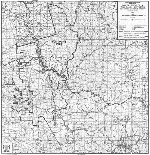
| This 1958 map shows the administrative boundary between Lower Trinity and the new Tish-Tang Ranger District, generally defined by Willow Creek and the westward-trending portion of the Trinity River. (click on image for a PDF version) |
During the latter half of the 1950s, there was a considerable sense of accountability by local and Regional Forest Service officials for the proliferation of sawmills in and adjacent to the Six Rivers; there was also a correspondent sense of responsibility for the well-being of the communities that were dependent upon those mills. Surprisingly little has been located thus far in the documentary record to trace all the reasons for its creation and dissolution just ten years later, but Tish-Tang Ranger District was at least partially an outgrowth of that thinking. Forest officials noted the dearth of forest management development north of the Trinity River on the sizable Lower Trinity Ranger District. Yet Lower Trinity had a full plate; the employees' workload was enormous. For the Lower Trinity Ranger District to focus on developing more timber sales, recreation opportunities, and building more road access north of the Trinity River would mean seriously diluting work being done on the remainder of the district. For this, and probably a host of other reasons, the decision was made to carve-out another district—Tish-Tang—from Lower Trinity to facilitate forest management in that area. As the former District Ranger of Tish-Tang, Walter Kirschman, stated: "Without going over-board," the forest officials felt a responsibility to supply an adequate stream of logs for the new mills that had sprouted-up in the area in response to creation of the Six Rivers National Forest. Co-located with Lower Trinity Ranger District at Salyer, within ten years, most of the objectives for Tish-Tang had been realized and it was reabsorbed into the Lower Trinity Ranger District (Kirschman 6-9-97: pers. comm.). [60]
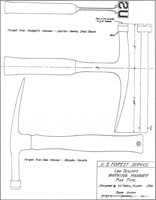
If the 1950s were a time of compressed program growth on the Six Rivers, they were also a time of innovation. One example is that of the Hallin Hammer: a log scaler's marking hammer. Lacking a distinctive way of marking logs that came from Forest Service lands, Vern Hallin started with a geologist's hammer and pick, extended the hammer head to prevent the user from hitting his knuckles, and put a "US" die on the striking surface. The pick end was also widened and forged into a chisel-like appearance; called a "spud;" it was used to strike the ends and sides of logs in order to test them for defects. This simple yet splendidly useful tool was designed by Hallin in 1954; he had the prototype forged at the Eureka Machinery Company. Word of its utility spread quickly and, in 1958, a Washington Office letter stated that it was to become standard Forest Service practice to provide each scaler with a Hallin hammer and belt rack. Its use was promoted in the Forest Service Scaling Handbook, FSH 2443.71 (Hallin 5-20-97: pers. comm.). [61]
|
| 1954 blueprint of the Hallin Hammer, a tool that was born on the Six Rivers and became standard equipment for Forest Service scalers. (click on image for a PDF version) Courtesy of Verne Hallin |
By 1956, the Six Rivers had 838 miles of Forest Service roads, 47 bridges, and 475 miles of trail; there were 53 miles of Forest Service telephone line, 14 lookout stations, and 22 heliports; there were 7 offices, [62] 18 dwellings, 5 barracks, 8 guard stations, and a total of 41 warehouses, barns and similar buildings; the automotive fleet numbered 54 units while the pack and saddle stock numbered 13 animals. [63] The total physical plant valuation was estimated at something over $6,000,000 (USDA, FS 1957: 7). Noticeable trends were that, since the 1947 situation report, the miles of roads on the Six Rivers had increased by 271, the number of bridges had increased by 4, and the miles of trail had decreased by 902. It was clear road construction was out-distancing trails to keep pace with timber sale demands, and that aircraft were both eliminating the need for the part of the trail system that had been maintained for fire suppression access and diminishing the number of lookout towers needed for fire surveillance.
By 1956, there were 66 full-time and about 550 seasonal employees working for the Six Rivers National Forest. A mimeographed pamphlet titled "Facts and Information on the Resources and Management of Six Rivers National Forest" amalgamated forest facts up to 1956. Noting that the Six Rivers organization was made up of "a small, dedicated group of public employees [who] own homes, rent homes, buy cars, food and clothing, pay taxes and generally contribute to the stability of the local economy," it was clear that the forest was countering criticisms about its modest but growing employee rolls and their contributions. By far, timber-related professionals and technicians dominated the full-time employee ranks while emergency firefighters dominated the temporary employee ranks. The list of functional areas included forest supervisor and staff (five full-time employees), district rangers and assistants (eight full-time employees), researchers (four full-time employees), timber sale (11 full-time and 6 seasonal), recreation (2 seasonals), fire (5 full-time, 42 seasonal employees, and 500 emergency firefighters), communications (1 full-time employee), automotive (2 full-time employees), engineering (1 professional and 3 technician full-time employees), and construction and maintenance (15 employees), as well as business management and clerical support (11 full-time employees). Moreover, the full-time supervisor, staff, district rangers, assistant district rangers and timber sale specialists were all professional foresters. It would be another couple decades before other specialists—hydrologists, biologists, archaeologists, botanists, ecologists, and the like—would begin to appear in significant numbers on employee rolls (USDA, FS 1957: 8). [64]
In the words of the Information and Education inspection progress report written in early 1957, the Six Rivers had rapidly "exploded out of a custodial stage to one of intense demand for resource utilization, especially in the field of timber and maintaining stream habitat for migratory fish." New and improved access, a by-product of timber sales, dramatically increased use of the forest by campers and anglers. Mining was also on the upswing. In light of the use boom, Six Rivers officials were patted on the back for their work in "paving the way for public acceptance in order to minimize interruptions, criticism, and appeals in the orderly pursuit of reaching each [forest] goal" (James 1957: 1).
The Six Rivers was projected to get "an annual cutting budget" based on harvesting 163 million board feet on a sustained basis. But forest officials, fearing pressure to overcut, urged higher level managers to give them "more precise figures on [estimated] volumes"; they were particularly troubled that volume estimates for Gasquet Ranger District were "too heavy" (James 1957: 1). The period of intense development that the Six Rivers was experiencing while organizationally a neonate, caused consternation. Administrative Assistant Kellner pointed out that meeting the harvest target meant selling 300 to 400 million board feet each year.
|
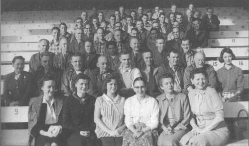
| The young Six Rivers saw its mission as bringing forestry and multiple use management to California's north coast. The cast of characters at this 1951 field trip on Orleans Ranger District shows that forest officials understood that the job entailed both technical and public relations aspects. Left to right: Alex Atran, Sacramento Valley rancher; James Byrne, Regional Engineer; Emmet Stewart, State Chamber of Commerce; Carl Wente, President, Bank of America, Clare Hendee, Region 5 Forester; V. M. Moir, Manager North Coast Council, State Chamber of Commerce; Paul Corbin, Eureka radio station KIEM; R. W. Mathews, Eureka businessman; William Fischer Six Rivers Forest Supervisor; Dr. Fred Glover, Professor of Wildlife Management at Humboldt State College; and L. N. Ericson, State Forest and Range Experiment Station. US Forest Service photo |
|
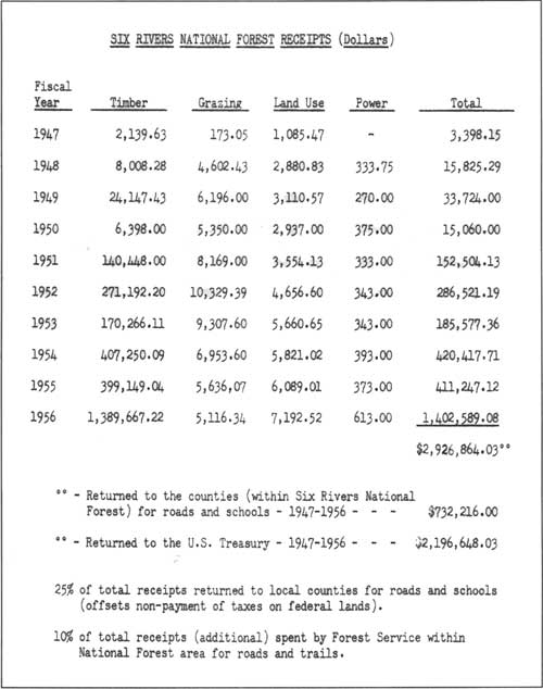
| This table of the Six Rivers' receipts from its inception through 1956 powerfully shows the proportion of the dollars generated from the forest's timber sales relative to dollars generated by other uses; that is, by 1956, timber accounted for over 99 percent of the forest's receipts. This table appeared in the pamphlet: "Facts and Information on the Resources and Management of the Six Rivers National Forest." (click on image for a PDF version) |
In 1956, the Six Rivers harvest totals increased from 22 to 55 million board feet and was projected to hit 100 million board feet in 1957. After a slight slump in 1954, "...the whole Humboldt-Del Norte area is 'booming' with the good lumber market." Adequate staffing became a severe impediment to getting the forest's work done, especially when many of the jobs were offered on either a temporary or seasonal basis (Kellner c. 1957: 2).
|
As commonly happens during economic downturns, the
smaller mills had the greatest proportion of closures.
|
Timber sale programs were being planned according to five year "cutting budgets." The plan for calendar years 1954 through 1958 for the Six Rivers and the NRPU used a sustained yield capacity of 152 million board feet per year. This entailed operator construction and major reconstruction on 205 miles of road at an estimated cost of $4,453,500 (Payne 6-10-54).
California, as a whole, claimed 20 percent fewer sawmills in 1957 than were active in 1956 which played into the business recession of 1957-'58. As commonly happens during economic downturns, the smaller mills had the greatest proportion of closures. As reported in Forest Research Notes of the California Forest and Range Experiment Station, "in spite of the shut down of some active mills and the elimination of some operable mills, 63 new mills were operated in 1957, two-thirds of them in the Redwood Region. However, the 63 fell far short of replacing the 203 mills active in 1956 which became idle or non-existent in 1957." The "regions" were defined in terms of counties such that the Redwood Region included the whole of Del Norte, Humboldt, Mendocino, Sonoma, and Marin counties. An interesting sidebar to this study was inclusion of an earlier, late 1947, listing of forestry graduates in the state's private lumber industry. Prepared by the Division of State and Private Forestry, the list of 112 foresters and the company for which they worked pointed to a leap in professional forestry within the industry within just two decades (USDA, FS 1958:1-2 and 12-47 attachment).
|
| Six Rivers employees at Redwood Acres in 1958. Note the significantly higher number of employees than just ten years earlier. From bottom, left, zig zagging: ? Albrecht, Joan Dean, Caroline ?, Kitty (Price) Lansdon, Eletta Kinnari, Maxine Keltner; 2nd row, r to l: ? Henry, Clarence Hill, Bruce Babbitt, Scollay Parker, Richard Kielhorn, Charley Bell, Cecil McAlister, Lyle Hill, ? Pippin; 3rd row, l to r: Lyle Davenport, Robley M. Broderick, Robert Lancaster, William Chase, George Ramstead, George Blodgett, Charley Brown; 4th row: ? Peterson, ? Burgess, Don ?, Hugo Maffey, Dave Albrecht, Wesley Spinney, Douglas Leisz; 5th row, l to r: ? Haske, Ted Hatzimanolis, ??, Jan Seils, ? Dell, ??, Ralph Accardi, Neil Magill; 6th row, r to l: Corson Williams, Charley Bennett, Murray Dulac, ? McKeown, ? Ramsey, Jack Fitch, ??, ??; 7th row, l to r: Joe Smith, ??, Angelo Lavagino, Ed Hurt, ??, ??, Edwin "Pooch" Rowley, John Van Akkeren, Morrison 'Jim' James; 8th, r to l: Ken Boe, Glenn Spencer ??, ? Kiutto, Vernon Hallin, Emmit Calvert. Employee identifications by Vern Hallin, Murray Dulac and Robley Broderick, Courtesy of Jerome Studios |
The Marginality Issue
Perhaps first used in reference to the Six Rivers in Cronemiller and Kern's 1949 GII report, what was termed the "marginality" of the Six Rivers from a timber operating perspective was the theme of a general forest inspection conducted in 1953. In a January 1954 report to the Regional Forester, Assistant Regional Forester Payne reflected that although the general area had experienced "tremendous change in lumbering activities" in the past few years, the forest's actual "cut has totaled only 30,000,000 [board feet] in the past two fiscal years." Payne pointed to several Forest Service-related causes that contributed to this marginality, foremost of which were lack of both adequate timber management planning and of fiscal controls. In his judgment:
This Timber Management planning activity is fundamentally more important than Forest personnel seems [sic] to realize and certainly the lack of adequate planning has been a significant factor in contributing to the difficulties that the Forest has experienced with its two or three outstandingly troublesome sales. It seems that the Forest has really fallen down hard on this phase of their job and that the Division of Timber Management [in the Regional Office] shares some of the responsibility for this failure. . . . Some of the failure is attributed to disagreement between technicians as to [the] method of determining allowable cuts, which does not to me seem to be a valid field for substantial disagreement at a time when the prospects of reaching the allowable cut are as nebulous as they have been to date.
Timber Management activities on the Six Rivers have been suffering many of the growing pains associated with development of new areas. . . attributable to complications of marginality due to market, species composition, character of the stand and extremely difficult logging conditions on much of the area. They have suffered more than the usual amount of grief through the activities of the promotional type of timber operator rather than the established and active mill or operation. . . . The Forest now has sufficient and adequate know-how, in respect to silvicultural treatment for its various timber stands, to facilitate orderly planning accomplishment. The experience to date with the promotional type operator, which they have been stuck with, will also prove invaluable in future dealings [Payne 1-20-54: 1-2].
Payne complained that the forest's timber management function was over-financed during fiscal year 1953, being funded on the basis of producing about 40 MMBF when the actual cut was only 13 MMBF. The situation was similar in 1952, though not as lopsided. Payne recognized that the picture was beginning to improve, especially in sale preparation. He wanted to see stringent follow-up and correction of the repeated problem of what he termed "overcuts." That is, deposits made by timber sale buyers based upon projected cut volumes were often woefully insufficient; it was not uncommon for cuts to exceed projected volumes within three weeks of commencing logging. Manual direction issued in late 1953 specified that the minimum purchaser deposit was to cover at least a 15-day harvest at the rate of harvest estimated by the Forest Service timber sale administrator (Payne 1-20-54: 3).
|
"Six Rivers is cursed by probably the poorest land
surveys in R-5. . ."
|
Another aspect of the marginality problem owed to the fact that "Six Rivers is cursed by probably the poorest land surveys in R-5. These land lines. . . are becoming more important every day & the best means we have of straightening out the mess these old surveys have created is accurate location of every section corner we can possibly tie down" (Johnson 6-26-53). The land line problem—traced to faulty, fraudulent, and incomplete nineteenth century General Land Office surveys—was most severe on the Lower Trinity District (Payne and Juntunen 1954: AM 18).
Under-developed transportation systems were also part of the marginality issue. Public roads built by county, state, and federal government were relatively scant and made large areas of standing timber inaccessible, given the logging technologies of the day. Government road construction programs were seen to have a key influence on log supply to mills and the economics of that supply. To illustrate the lag of road construction in this part of California, on the road that is now largely assumed by Highway 299, the first vehicle bridge across the South Fork Trinity, connecting Humboldt and Trinity counties, was not built until the fall of 1913. The first permanent survey for the Salyer-Burnt Ranch road was not started until March 1915, and it was not until 1923 that what came to be called the Trinity River Highway went through between Arcata and Redding (Salyer n.d.: 21).
A key to the more Pacific-oriented transportation system was the shallow and tricky Humboldt Harbor. In 1953, there was considerable congressional discussion about harbor improvements to improve marketing of timber from the area tributary to the Six Rivers. At stake was congressional funding assistance to deepen the channel across Humboldt Bay bar to permit loading full cargoes for coastal or inter-coastal shipping. Representative Hubert Scudder's request for information was directed to the Chief of the Forest Service, Richard McArdle. Undoubtedly ghostwritten by someone closer to the problem, the letter exudes the promise of the new forest:
Northwest California is just about the last timber frontier in the 48 States. The timber industry in Humboldt and Del Norte Counties has expanded sensationally since the close of the war. The depletion of old growth timber in western Washington and northwest Oregon has resulted in a migration of Forest products industries from that area into north most California. This migration is still in progress.
A full-scale development of the potentialities for timber production in northwest California and southwest Oregon is impeded by lack of adequate transportation facilities. For rail shipments lumber must be brought south to Arcata or Eureka, California, or north to Coquille, Oregon. The distance between these two points is 220 miles on the coast highway. For lumber shipments by water the only available harbors for ocean vessels are in Humboldt Bay in California and Coos Bay in Oregon. The distance between these two harbors is 240 miles on the coast highway. At Crescent City, harbor improvements have been installed which permit the use of barges but not oceangoing vessels. Some lumber is now being barged from Crescent City to Humboldt Bay for transfer to coastal and inter-coastal steamers [McArdle 4-8-53].
Because Humboldt Bay could only accommodate partially loaded vessels, McArdle argued that the entire tributary area to the Six Rivers was handicapped and consequently, adversely affected stumpage values. He also noted that the Six Rivers area had "experienced phenomenal growth in the past ten years," and that Humboldt County ranked second in lumber production. He highlighted his points by stating that the current rate of cutting on the Six Rivers, tributary to Humboldt Bay, was "approximately 25 million board feet compared to a sustained yield cutting capacity of about 90 million feet." Pointing out that national forest timber was far less accessible than private timber, the discrepancy between the sustained yield capacity and the current cutting rate was seen as an "undercut" and a loss of about $650,000 of gross revenue annually to the United States. Obviously, McArdle and the Forest Service vigorously endorsed the harbor improvements.
In addition to touching on the marginality issues, the two fundamental findings of the Payne and Juntunen GII in May and June of 1953 were the need to embody a multiple use program and the need for orderly planning. The inspectors believed that the forest's information and education program emphasis on fire prevention could "over sell" its interest in that single program area to the detriment of multiple use. [65] Planning would materially aid the forest in its next developmental stage and was necessitated by the anticipated demand for forest products and services in the coming years. In the area of land exchanges, the inspectors urged forest officials to formally make the NRPU part of the Six Rivers (Payne and Juntunen 1954: LM 1, FR 1).
The 1953 GII also highlighted a significant jump in recreational use on the Six Rivers between the year of the current and the 1949 inspection. Earlier, there were plenty of unimproved, free-use areas available. Use of the forest's 36 improved campgrounds—though inadequate relative to demand for several years—had caused little harm. "However, the great increases in population. . . make the problem of the use of unimproved areas a real one. The matter of sanitation and maintenance of pure drinking water no longer permit unrestricted use..." Trailers were also beginning to appear in appreciable numbers in Six Rivers campgrounds. There were certain advantages noted by the inspectors from use of trailers, particularly compared with providing additional summer home lots, but it was hinted that the forest might do well to limit the length of occupancy at the most desirable units to stave off long term occupancy. The GII also noted that receipts on the Six Rivers had increased from only $14,893 in 1950 to $236,200 in 1952, owing almost entirely to the jump in timber sale receipts. Excluding capital investments, 1952 receipts exceeded operating expenses by about $6,000 (Payne and Juntunen 1954: FR 3, AM 3).
|
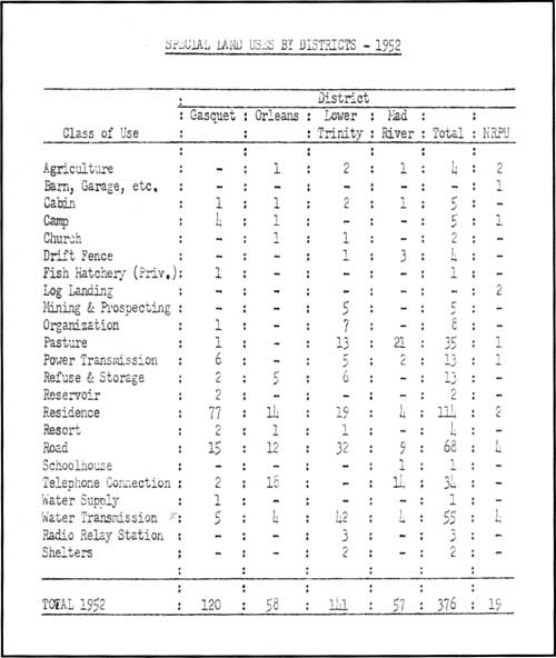
| This appendix from B. H. Payne's 1953 General Integrating Inspection report shows the volume of business and relative activity for various special uses during the Six Rivers' early years. (click on image for a PDF version) |
Adequate employee housing continued to be a bugaboo for the Six Rivers. Though not as desperate at Gasquet and Orleans, extreme housing shortages plagued Lower Trinity and Mad River. A large part of the problem was traced to increased populations due to new sawmills and road construction work (Payne and Juntunen 1954: AM 12). [66]
Payne and Juntunen, like inspectors before them, commented on the forest's rapid conversion from a custodial status to a "managed unit." Exponentially increased demands for recreation facilities, timber sales and various special uses were expected to continue, making development of realistic, foresighted land use planning essential. Like Cronemiller and Kern, these inspectors also urged the forest to assume its proper role in water management for the north coast. With the north coast comprising only two percent of the population but yielding 41 percent of the State's run-off, demands for the water—not just local ones—were spiraling upward. The demand for water resources was expected particularly from the southwest part of the state, composing 53 percent of the population and possessing only two percent of the annual run-off. A fourth of California's total run-off flowed through the Six Rivers' watercourses (Payne and Juntunen 1954: FR 5-6). A 1957 Six Rivers fact sheet proclaimed that "water, a necessity for people, plants and animals, is the most important single natural resource of the National Forest." It was estimated that 20 million acre feet of water was produced off north coast streams (anon. 1957: 4). [67] The Six Rivers encompasses about 15 per cent of the total Klamath and Trinity river watersheds, about 10 percent of the Trinity, and about 85 percent of the Smith River watershed.
Though still primarily concerned with game species, wildlife management on the Six Rivers was closely linked in the 1953 GII with the economy and growth experienced by the area. Rather than being less important relative to the phenomenal growth of the lumber and wood remanufacturing industries, the economic benefits of hunting were increasing proportionately. With the expansion of timber cutting activities expected to hit the Six Rivers full force in the next few years, various impacts on fish and deer habitat were presaged. While deer habitat was expected to improve with creation of more cutover or thinned areas, fish habitat was expected to be even more threatened. The inspectors noted that the Six Rivers currently had sufficient knowledge to integrate stream protection into its logging plans in terms of keeping them free from debris and obstructions. But the forest lacked "information of what factors of land management are apt to adversely affect the capacity of salmon and steelhead streams as spawning grounds." Working circle management plans still lagged and, in addition to urging that their preparation be a forest priority, the inspectors suggested that the forest combine some of its small working circles in order to simplify the management planning (Payne and Juntunen 1954: FR 8, 12).
Payne and Juntunen characterized the Six Rivers' fire load as generally not as heavy as indicated by the 232 fires reported for 1947 through 1952. Mitigating the fire average of about 38 per year, the fire season was short, with just 10 to 15 critical fire days each season. The major fire problem noted was the build-up of heavy slash inside and outside the forest boundary and the occurrence of lightning fires in areas inaccessible by roads. Fifty-five percent of the forest's fires were human-caused, and over half of those were attributed primarily to "local people, smoking, incendiarism, and lumbering." And while human-caused fires accounted for 94 percent of the burned area for those years, incendiary fires on the Klamath River strip—about which more will be said in the next section—dropped significantly. Logging slash on private lands within the forest's protection boundary totaled about 30,000 acres. The forest's six primary lookouts were staffed only for short periods, during the height of fire season (Payne and Juntunen 1954: FP 14). [68]
The steep increase in logging and milling operations on the forest, from 19 in 1947 to 106 in 1952, brought a corresponding increase in logging slash acreage: from 3,655 acres in 1947 to 21,855 in 1951, primarily on private land within the Six River's fire protection boundary. The problems on the Six Rivers were seen as particularly acute in Douglas fir stands, where the "heavy per acre cuts"—grossing an average of 60,000 board feet per acre in clear-cut units—left a slash hazard that spread rapidly, and was resistant to control (Jarvi 8-8-52: 7 & charts 1-4). From 350 acres of logging slash in 1947, that figure rose to 1,250 acres in 1951 on national forest sales. On private land for those same years, slash accumulations jumped from 3,305 acres to 20,605 acres. Creating not only exponentially increased fire hazard, slash accumulation delayed reforestation efforts and created more unsightly scenes which were increasingly in the public eye (Jarvi 8-8-52: 5). The aftermath of logging continued to plague the Six Rivers. Usually framed primarily as a fire control problem, slash and logging area clean-up was growing to monumental proportions (Branch 10-3-56: 1).
|
|
Despite special protection, lookouts sometimes fall victim to
lightning. Bear Basin Butte was hit in 1942 when the strike went through
and out the south side of the building to the telephone switch box on
the pole outside. It was noted that, when the bolt hit, the lookout and
his wife were standing opposite each other, across the fire finder;
they were knocked flat and, afterward, 'felt groggy.' Some years
after this incident, Bear Basin Butte Lookout was decommissioned and
destroyed. In 1997, the CCC-built Camp Six Lookout that had been on Upper Coon Mountain was refurbished and reassembled on Bear Basin Butte by the Six Rivers National Forest in partnership with Pierson Building Center. The lookout, along with a 1935-style cabin built by Pierson, are available for rent. Here, the public can get a taste of what it was like to be afire lookout, Courtesy of the Charlie Brown family |
Native Americans and the Early Six
Rivers
A large part of what passed as tribal relations in the early years of the Six Rivers was really the forest's relationship with the Indian Service... and most of the forest's contact with the Indian Service concerned fire protection agreements and forestry objectives. Moreover, the institutional ways of the two agencies were divergent; Six Rivers officials frequently groused about the fogginess of the Indian Service's forestry objectives and about its timber sales typically being offered on "a faller's selection basis and with no supervision." For the four mills on the Hupa Reservation, the Indian Service handled Indian and adjacent national forest timber. The Six Rivers' aim in its first few years of existence was to develop a cooperative agreement with the Indian Service for sustained yield on the timber lands serviced by these mills (Cronemiller and Kern 1949: 19-20, 29).
Today, the forest's relationship with over a dozen Native American groups that traditionally occupied what became the Six Rivers National Forest contrasts with the forest's earlier relationship with native people. [69] As of 1997, forest officials have a formal, government-to-government relationship with four, federally recognized tribes and eight rancherias: the Yurok, Karuk, Hupa, and Round Valley Indian Tribes; and the Elk Valley, Smith River, Resighini, Big Lagoon, Trinidad, Table Bluff, Rohnerville, and Blue Lake rancherias. In addition to general forest management topics, forest and tribal officials consult on an array of issues having particular resonance with Native American communities, ranging from use of herbicides, enhancement of traditional gathering areas for basketry and food stuffs, and protection of Native American cultural landscapes and spiritual locales.
Much of this change has occurred within the past two decades; it was not long ago that native people and the Six Rivers policies were fundamentally at-odds. Surprisingly, a window into the character of early Six Rivers attitudes and actions regarding native people is provided by the 1949 General Integrating Inspection report. Within the functional area of fire control, the GII contained subsections on planning, preparedness, seasonal personnel and stations, prevention, and the "Indian incendiary problem." Within each subsection, the inspectors used language that would be unlikely to appear in a contemporary account. But in addition to the more dryly reported elements—such as the need to update the forest's fire plan, a recap of the past three years of fire history, and a characterization of the forest's fire behavior—they also pejoratively referenced the "background of the local seasonal personnel" and their aptness to be "careless, daring, and less cleanly." Those remarks were, however, comparatively complimentary when measured against what the inspectors said in the subsection on incendiarism. Moreover, their account is extraordinarily telling, not only of their personal attitudes, but also of the agency's relationship toward native people during that era.
|
Among Region 5 forests, the Six Rivers is legend
for being comprised of lands that were the traditional homelands for a large number of Native
American groups who represent an unusual diversity of cultures and
language stocks.
|
Among Region 5 forests, the Six Rivers is legend for being comprised of lands that were the traditional homelands for a large number of Native American groups who represent an unusual diversity of cultures and language stocks. Perhaps owing to the area's relative remoteness and late economic and industrial development by immigrant groups, native people—especially the Hupa, Yurok, Tolowa, and Karuk—managed to maintain the threads of their communities that provided the basis for their strong social and political presence today. There has been a long-standing tension between native people and the Forest Service with the former having an elemental tie with the land and its resources and the latter Congressionally mandated with stewardship of those lands in order to produce goods and services. It has taken a long time to conceive that these interests are not necessarily oppositional.
The attitudes reflected and reported by Inspectors Cronemiller and Kern toward Native Americans is shocking to contemporary sensibilities.... There is an impulse to re-tell what was said using more benign words in the hope of being more respectful and less inflammatory and offensive. But when such language typified broadly held attitudes that translated into agency practices, it is important to let the historical record speak for itself. This is particularly true when today's public may regard such a re-telling with disbelief—thinking it impossible that the agency held such racist attitudes and condoned, or turned a blind eye to, certain reprehensible practices that were commonplace only a little over a generation ago.
The inspectors opened their discussion by setting the stage: 1949 had been a year beset with a high number of Indian-caused fires, especially along the Klamath River strip on Orleans Ranger District and on the Hupa Indian Reservation. Aware of this, Cronemiller and Kern lobbied for and received funding for special Indian crews—"screened as non-incendiarists by the fire prevention officer"—to cope with what the inspectors termed "organized incendiarism." Although Indian patrol crews were highly effective, the inspectors believed the Indian arson problem was "broader and deeper than often conceived." Native Americans of this area were labeled "shrewd in uncivilized ways" and...
in reality, have simple minds. They have inferiority complexes and are more or less confirmed in their thinking that the land should be theirs and that incendiarism is one way of retaliation towards the white man for various controls, disciplines and laws....
They react against anything that smacks of oppression and this may be only regulation or a process of law. . . .
The drunken Indian has no inhibitions and will do the thing he has been thinking about. If that means retaliation towards controls or knifing an enemy, that he will do. A number of roadside fires are started willfully by drunks....
The Indians are improvident but good workers. At present there is work for those who want to work yet they will take a day off when they don't feel like working and thus lose their jobs. All of them have automobiles and most are paying on them. When it appears they may lose their car through failure to make payments, 'job' fires may result. . . .
The 1949 situation with a number of incendiary (Indian) fires is really a somewhat normal situation—partly retaliatory against the Indian Service and the government and perhaps partly economic. Wage rates for fire fighting are above those for common labor on the reservation and because of long hours the pay is greater per day than private industry....
Solving the problem of the half-drunk Indian and his retaliatory actions is a long process involving possible (a) enforcement of liquor laws in respect to Indians, and (b) long time educational programs in agriculture and forestry among the high school students. Law enforcement is, of course, essential but is a much different problem than that of the white man's conception, yet no one seems able to say what is proper punishment for an Indian. One sheriff says a rubber hose filled with buckshot is perhaps the best. Fines aren't satisfactory in all cases since the culprit is usually 'broke' and will be bailed out by parents with the result the punishment is ineffective and hits the wrong party. Going to jail is termed 'going to school' by the Indians and holds little terror after the first experience. The idea of the State in this District is first get the Indian into a jam, then win his friendship by getting him out of it with probation. This is effective with some.
The tendency of justices is to be lenient, assessing small fines or probation. The Indian Service administration is rated well by the local ranger, but Government officials are either accepted by the Indians or not. If not, they will make it really tough. It appears the present superintendent is accepted, as is the Lower Trinity District Ranger. [70] The Indian Service forester is disliked by the Indians and they are out to get him [Cronemiller 1950: 26-28].
Along with their disturbing, racist beliefs, one also senses Cronemiller and Kern's frustration and their recognition of some of the larger social issues that hit Native American people especially hard: fundamental differences in land ownership concepts, regulation in previously unregulated aspects of everyday life, apparent disproportionate alcoholism among Native Americans, un- and under-employment.., all of which contributed to "the Indian incendiary problem." Regarding the sheriff who commented that "a rubber hose filled with buckshot is perhaps the best" punishment for an Indian, it is impossible to discern Cronemiller and Kern's reaction. However, it is clear they recognized that law enforcement was particularly problematic when any outside agency's regulations were imposed within Indian communities. It is also clear that Cronemiller and Kern simply lacked the awareness to understand that much of what they termed as incendiary was cultural burning to enhance the foods, fibers, and traditions that were integral to the life ways of local people. [71] This gulf of misunderstanding was bolded by the inspectors' remark that the forest was home to "a considerable number of rural people [and that] a major portion of the population in and adjoining the forest is of Indian blood.... [In their eyes, the forest] "contributes little in the way of livelihood but is increasing in importance" (Cronemiller and Kern 1949:1).
There is no doubt that deliberate fires were set and that they posed a major concern for Forest Service officials. In fact, the number of arson fires had jumped from none reported in 1948 to 17 in 1949, with scores more started immediately adjacent to the forest (Cronemiller and Kern 1950: 24). But ignorance of Native American cultural practices coupled with equating Klamath River "incendiarists" with "Indian," and the prepossession against an entire racial group had the effect of clouding problem-solving and of poisoning relations for years to come.
|
. . . the prepossession against an entire racial
group had the effect of clouding problem-solving and of poisoning relations for years to
come.
|
Hostility and friction between Native Americans and various government agencies—the Forest Service being just one—sometimes escalated into property damage and to threat of bloodshed. The State Division of Forestry experienced difficulty in enforcing fire control laws along the river strip. For example, after being threatened, Division of Forestry personnel backed-off from implementing their fire control program. One result was that Forest Service boundary lands were being "badly scorched" and when fires occurred on the strip, Forest Service firefighters were forced to "go a considerable distance outside to stop threatening fires." Cronemiller and Kern lamented that: "It looks as if we will have to live with this problem a while longer—until the area becomes more civilized." Exhibiting a thread of cultural awareness, they instructed the Six Rivers to extend a hand to the State and offer any assistance needed in developing "an attitude towards protection among the local people. Perhaps the burning of basket grass areas and doe pastures would to the job . . ." (Cronemiller and Kern 1950: 29).
A letter from the Forest Service's State and Private Forestry group in late 1950, commented on one of the difficulties of coordinating fire protection along the Klamath River strip, particularly on the north side, down-river from Weitchpec to Blue Creek. Labeling the area the "West of the Pecos River Strip," reference was made to the new presence of a full-time patrolman there for the full fire season in 1950, noting that: "This apparently had an effect because there has been little fire trouble this year." An initialed marinal comment to that point was that the "Warhoops kept busy in mills at Hoopa is a more fundamental reason" for the precipitous decrease in arson (Branch 12-18-50).
The Six Rivers' and Regional linkage between intentionally set fires and Native Americans was also reflected in a 1952 fire inspection report:
The incendiary problem can become explosive if the Indians exercise their past practices to the ever increasing heavy hazard slash areas. One large operator, who is operating in the area between the Klamath River and the Forest boundary north of Weitchpec, referred to as the 'river strip', has refused to employ Indians, thus far. This operator is a recent arrival from Washington. He has some 20 million feet of down timber on the area. The Orleans F.C.A. [fire control assistant] has personally contacted this operator regarding the employment of Indians as a safeguard to 'retaliations' thru fire. This point should be followed-up aggressively by Forest and District personnel. Although this area is not within the Forest protection boundaries, it is a problem area adjoining N. F. timber.
|
. . . questions of resource ownership and economic
benefit swirled around the incendiarism issue.
|
If some local Native Americans started fires that had no cultural underpinnings, the fires did appear to have had a socio-political agenda... and it appears to have been effective in getting the attention of Forest Service officials. Though there was no reference in this 1952 report to the intense land and resource use disputes over the river strip—both between the government officials and Native Americans and among Indian groups along the Klamath River—clearly, questions of resource ownership and economic benefit swirled around the incendiarism issue.
Cracks in the Maximization Perspective
Organizationally, the Forest Service was showing signs of moving into a period of fundamental transition between its second and third eras as an agency—between intensive management for commodities toward a more holistic, forest health perspective. However, the Six Rivers had inherited a structure, an institutional culture, and personnel roster that largely mirrored the principles characteristic of the first, custodial, era of Forest Service administrative history. The National Forest Manual guidance from which most of the forest's leadership had been schooled stated that the first building block of the Forest Service was the ranger district, and that the person in charge of the ranger district was the district ranger.
The district ranger was primarily a field man rather than an office worker. Since the district ranger is in charge of from 50,000 to over 300,000 acres and his job is primarily a field job, it is evident that his work calls for much travel, and that he must expect to spend much time away from home.... He should be content to raise his family in the village or isolated locality where the headquarters of district rangers are often necessarily located.
As a rule the district ranger's prestige, and therefore his usefulness, increases with the length of stay in, and consequent firmer establishment of himself as part of the community....
Men selected for district ranger positions should be young, of rugged physique, and in good mental and physical health. A high school education, or an equivalent amount of schooling, is needed. Other things being equal, the man with technical training in forestry and range management will be most successful in dealing with the varied technical problems which confront a district ranger.... It is policy to recognize that the principal line of advancement to higher positions lies through service as district ranger.... Improvement work, fire fighting, and the like often require crews with foremen in charge, but it will be the rule that such crews will be under the supervision of the district ranger and that he is ordinarily personally responsible to the supervisor for everything in his district except work requiring the qualifications of the specialists who are attached to the offices of the supervisor or the district [regional] forester [USDA, FS Manual c. 1927: 4A, 5A].
The work at the ranger district level had traditionally been unspecialized and required a ranger with considerable woodsman skills and diplomacy. But, by the end of the second world war, it was evident that demands on national forest system lands were increasing exponentially; a ranger, an assistant, and a small seasonal crew could no longer effectively shoulder the workload. Not only was the volume of work changing but, more importantly, so was the nature of the work. As the agency shifted from a custodial toward an intensive managerial paradigm of forest stewardship, specialists increasingly had a role. [72] When the Six Rivers was created, the district rangers still reflected a generalist approach, but the ranks were becoming increasingly professionalized. Foresters comprised the bulk of the ranger and assistant jobs, but the classification of "forester" was developing subspecialties such as silviculture, fire, recreation, and administration. Specialists, such as civil engineers, were gradually becoming more numerous at the supervisor's and regional offices.
|
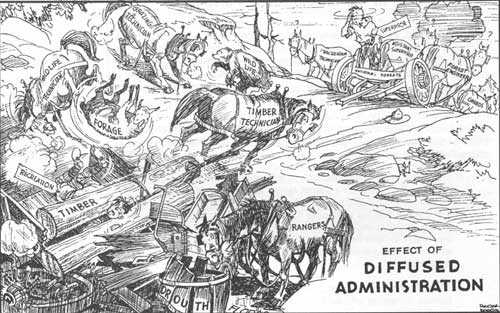
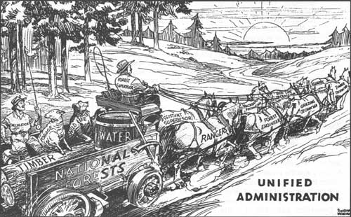
| This character of the virtues of a diffused versus a unified administrative structure hints at the dramatic change in the volume and nature of Forest Service work and at the growing pains it spawned. |
|
". . . local people have the prospector's optimism
and at least get some
satisfaction in having a claim since one doesn't cost anything to keep"
|
Rapid developments in the north coast timber industry, spurred by creation of the Six Rivers National Forest, had ramifications for the new forest's land exchange, special use, and recreation programs as well as the more direct effects in the timber and roads functions. R. W. Beeson, reporting to the Assistant Regional Forester for Recreation and Lands remarked:
Until recently, there were no particularly difficult problems of land management along the Trinity and Klamath Rivers. Now, almost overnight many large sawmills have been established in an area where formerly there were mining claims and a few widely scattered homesteads. Land needed for home sites, industrial and business sites has become an acute problem. Unless the Forest Service wishes to be forced into a special use business involving all the difficulties of unincorporated towns, an exchange of lands in the near future is imperative. The objective should be to exchange land near the mills and villages for areas needed for public use, including access to the river for recreationists and fishermen. It is apparent that most of the bench land between Hawkins Bar and Willow Creek will be in demand for private uses. If we should delay action until a townsite bill passes Congress, we will be forced to sell this land and have no opportunity to make advantageous exchanges [Beeson 10-5-55: 3-4].
Forest surveys identified the "highest use" for special areas in order to provide for a specific, dedicated use. For example, many of the river areas near small communities were labeled for recreation development: campgrounds, boat launch areas, day use areas, picnic areas, and the like. But despite this identification process, often other, incompatible uses prevailed. Indeed, the first general inspection of the Six Rivers had recognized that the forest had substantial untapped recreational opportunities, and that their development was hampered by "a considerable alienation of land, particularly along the major watercourses" which were also often townsite areas or adjacent to them. Public use of these riverine areas was also suppressed by the mining claim situation on the Six Rivers, where mineral values were "low but widespread." [73] In the broader view, placer claims on the Smith, Klamath, and Trinity rivers were, from the outset of the Six Rivers, "a serious barrier in developing proper land use. Values are known to be low yet the local people have the prospector's optimism and at least get some satisfaction in having a claim since one doesn't cost anything to keep" (Cronemiller and Kern 1949: 1, 21).
Indeed, fishing was the greatest recreation use on Gasquet, Orleans, and Lower Trinity districts. Especially on the Klamath River, the mid-August to mid-September steelhead runs attracted huge numbers of people, packing campgrounds and private river resorts. Inspectors Cronemiller and Kern believed that the new Weitchpec Bridge, possibilities of Klamath River Highway improvements, and P.G. & E.'s bringing in power were indications of new growth potential in the Orleans area, and that the Forest Service had an important role to play in "pulling the Orleans community out of its present doldrums as a one phase economy-fisherman's resort and plan for a greater stability and higher standard of living" (Cronemiller and Kern 1949: 21).
The Six Rivers' Information and Education Work Plan for 1955 is a telling vantage point of the forest's emphasis areas during that period of its history. Timber was, without a doubt, the fulcrum of the Six Rivers' work program; the I & E Plan's 1955-1956 objective was simply:
To promote better public understanding and support of the Six Rivers National Forest Timber Management and development program.
|
Timber was, without a doubt, the fulcrum of the
Six Rivers' work program
|
Six Rivers officials saw themselves as previously having over-emphasized the forest's fire job. Now that other agencies were taking more responsibility for fire prevention and control, the Six Rivers was advised to shift its attention to helping people "appreciate the magnitude of the job of making this resource [timber] available. . . [and] the complexities of 'managing' for the long time future." Because the inland timber resource had been virtually ignored, they saw "an opportunity to get in on the 'ground floor'." To every forest officer, the I & E Plan implored:
Emphasis will be given timber management as it is our newest and heaviest activity. We want to get off on the right foot. Other activities, however, should not be put aside completely. Opportunities to discuss and explain objectives and correlation of other activities with timber management should not be overlooked.
Each forest officer was expected to take an active part in the I & E Program, "[i]n spite of seemingly impossible work load." The I & E Plan was partly comprised of a list of governmental officials, conservation groups, industry groups, media, and other special interest groups coupled with the name of the key contact, the officer responsible for the contact, the minimum frequency of contact, the general purpose of the contact, and the special interests of the target groups (USDA, FS, 1955: passim).
Though much of the 1961 I & E Plan parroted the 1955 version, the 1961 "Five-Year I & E Analysis and Plan" took a different approach, reflecting a new emphasis on multiple use. Its 1961 to 1963 objective was stated as:
To promote better public understanding support of the Six Rivers National Forest management and Multiple Use Program.
|
. . . pressure on the Six Rivers to provide the
full allowable annual cut to the timber industry was unreasonable—it
was neither "physically nor financially feasible."
|
Further, instead of isolating a single information and education problem to be addressed, the plan listed a range of problems, a short analysis of them, and the action to be taken and the media tool to be used. The 1961 plan listed deer management, rights-of-way, and timber as the focus issues, though all were connected with the Six Rivers' development of its timber resource. Deer were believed to be causing serious impacts on the "survival and growth of fir seedlings and plantations"; lack of rights-of-way was becoming a serious impediment to keeping the timber sale and road programs going; and pressure on the Six Rivers to provide the full allowable annual cut to the timber industry was unreasonable—it was neither "physically nor financially feasible." The I & E Plan explained that the Six Rivers had been in the "timber sale business only during the past 8 years to any great extent," and that "consolidation of private timber and land holdings by a few large timber companies" had netted severe criticism of the forest. Seen as part of a state and national issue, the plan directed that contacts stress such things as the need for soil and stream protection, planning and supervision of timber sales, benefits of "orderly and sustained yield harvest vs. 'operator choice' of timber," and conduct of "show me trips" for key leaders in addition to annual timber sale operator meetings. The plan also identified that forest officers needed to publicize progress and problems with the timber sale program—such as rights-of-way—and to meet regularly with key individuals and groups to "seek their understanding and cooperation" (USDA, FS 1961: passim).
|
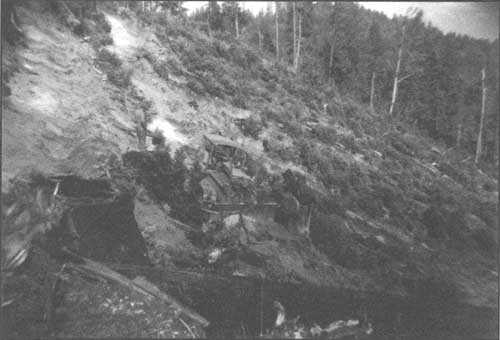
| This photo, taken in 1960, shows a D-8 tractor building terraces as a hedge against erosion prior to restocking with trees. This was on the Leary Creek Sale, Orleans Ranger District. US Forest Service photo |
From Creel and Bag Limits to Restoring Habitat... An
Example of a Changing Paradigm
Fundamental reorientations within the Forest Service seem to be the cumulative product of a critical mass of more modest changes in perspective that take place over time. One of the areas in which elemental shifts in perspective were taking root was in post World War II fish and wildlife management. At least as early as 1944, the Forest Service in California perceived that it needed to change the way it viewed this program. Forest Service analysts on the "Interbureau Coordinating Committee on [the] Post War Program for Agriculture in California" reported in 1944 that "[P]erhaps the most serious failure in wildlife conservation has been in misdirection of effort toward regulation of the sportsmen rather than toward restoration of the environment." Attempts at wildlife management through setting hunting and fishing seasons and limits was followed by establishment of refuges and elimination of certain species from the list of take-able game. When those efforts still failed to produce the desired results, interest peaked in transplanting native species, introducing exotics, and artificially propagating game birds and fish.
While it still operated entirely within the paradigm of providing desired sport hunting and fishing experiences, this study candidly summarized various negative influences upon natural wildlife ranges, including the ill-effects of single-use management, "such as timber production, where the elimination of the oaks and other broad-leaved species within a particular area materially reduced the feed to sustain wildlife. Outstanding as an example of the failure to recognize wildlife values has been the destruction of fish life in the management of water" (USDA, RICC 1944: Forest Lands Section 41-43).
The 1946 animal census for the Six Rivers highlighted the game and fur bearer species, with particular attention to deer and bear, counting 8,300 blacktail deer and 1,055 black bears (USDA, FS 1947: B-7). Population estimates for these species classifications were made for each ranger district in 1946 (USDA, FS 1947: C 4, 14, 24, 34): [74]
| Gasquet | Orleans | Lower Trinity | Mad River | |
| Blacktail deer | 500 | 1,500 | 1,880 | 5,000 |
| Black bear | 480 | 250 | 120 | 200 |
| Bobcat | 330 | 800 | 225 | 450 |
| Mountain lion | 30 | 15 | 3 | 20 |
| Coyote | 10 | 200 | 75 | 500 |
| Fox | 180 | 75 | 115 | 250 |
| Marten | 40 | 100 | 19 | - |
| Mink | 240 | 250 | 180 | - |
| Otter | 75 | 50 | 10 | - |
| Raccoon | 50 | 550 | 250 | - |
| Ringtail cat | 80 | 375 | 125 | 75 |
| Skunk | 150 | 250 | 275 | 2,500 |
| Weasel | 450 | 75 | 60 | - |
| Badger | - | - | 60 | 20 |
| Fisher | - | 25 | 2 | - |
| Muskrat | - | - | 85 | - |
|
From its inception, the Six Rivers was prized as a
less-developed and less-frequented place...
|
From its inception, the Six Rivers was prized as a less-developed and less-frequented place when compared with many other California national forests. As such, its attraction for anglers and hunters was significant and, as basic access improved, their numbers increased accordingly. In 1949, the total number of fishing use days for the Six Rivers was 24,780; hunter use days numbered 7,555. The Six Rivers boasted an estimated 785 miles of fishing streams and, after a lull during World War II, the State began an aggressive fish planting program on the forest. In 1946, 100,000 rainbow and speckled trout were planted in Six Rivers streams with fish from the Prairie Creek and Mount Shasta hatcheries.
By 1949, there were glimmers of a focus on habitat, particularly in relation to fisheries management. Cronemiller and Kern belied their frustration with State programs that responded to pressure from angler groups by building fish hatcheries instead of improving spawning habitat. They urged that Six Rivers officials work "for honest biology in fish and game with competent technicians working on the problem of this tremendously important resource. . . ." The inspectors also seemed nonplused by sportsman groups that belittled the job to be done. They entreated forest officials to work closely with sportsmen to help them understand "that wildlife management is a professional job and they should do more listening and less advising" (Cronemiller and Kern 1949: 23; Fischer 1950: appendix tables XI and XII).
In 1950, Supervisor Fischer stated that the forest's objective in recreation management was, foremost, to preserve and enhance the recreational values of national forest land and, secondarily, to develop recreation improvements with county and state programs. Fischer identified a close relationship between fish and wildlife on the Six Rivers and recreation, since hunting and fishing formed the area's major recreation attraction. Where the shortage of recreation facilities had earlier not caused huge harm to the forest because of the abundance of available, free, unimproved areas, the growing population and resultant increase in demand for recreation facilities were causing critical problems; especially in sanitation and water purity. Fischer also cited the increasing pressure on the Six Rivers to designate summer home tracts and organizational camps (Fischer 1950: 13-14).
|
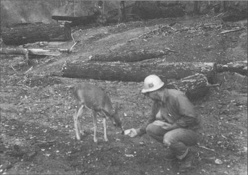
| Clear cuts during the Six Rivers' timber boom years were promoted as beneficial for deer. Believed to be similar to the effects of fire, the openings created by clear cuts started succession over. As these areas initially revegetated with grasses and forbs and then with shrubs, deer were provided with a transitory food source until the site gradually reforested with hardwoods and conifers. In the late 1960s and 1970s, wildlife biologists encouraged such harvest prescriptions that produced more "edge"—transition zones between vegetation types. However, when over-used over time, the practice led to the formation of large, contiguous blocks that, while they provided edge, overly fragmented the habitat. US Forest Service photo |
|
When wildlife management emerged as a profession
within the Forest Service, the emphasis was still on consumptive benefits to humans.
|
Adopting the language of farming and maximization, in 1950 Supervisor Fischer stated that the Six Rivers' objective in wildlife management was "to obtain the maximum fish and wildlife production from the National Forest, consistent with other uses; to accomplish this through maintenance and development of the habitat; and to promote the most efficient sustained harvest of the crop by sportsmen." As he saw it, the primary fish and wildlife management problem for the Six Rivers was to furnish the "room and board," or habitat, for fish and wildlife and for the State Division of Fish and Game to manage "harvesting of the crop." He noted the need for heightened cooperation between the State and the Six Rivers, especially as the State moved into an era of "real game management as compared to mere enforcement of seasons and bag limits." Fischer saw it as incumbent on the Six Rivers to place a higher value on wildlife and "preservation of migratory fish" recognizing the ever-increasing reliance on National Forest land to satisfy the demand for hunting and fishing opportunities (Fischer 1950: 12-13).
When wildlife management emerged as a profession within the Forest Service, the emphasis was still on consumptive benefits to humans. [75] But, by the latter 1960s, there was a shift in applying wildlife management to provide non-consumptive human benefits as well. Hunting had also "changed from an important food-producing and sporting activity of a predominantly rural population, to an important sporting and sometimes food-supplementing activity for nearly 25 million" people in a predominantly urban nation by the early 1970s. This called for a shift to also occur in wildlife management strategies with "more explicit management objectives" and measurement of objectives rather than "number of game bagged" (Hendee 1973: 175). There were even whispers of wildlife management for maintenance and promotion of endemic, non-game species diversity.
From Summer Homes to Recreation Residences...Another Changing Paradigm
|
. . . it was not uncommon for people to secure
what, in actuality, were summer home sites through the use of mining laws that allowed for
occupancy and use of public land if it was necessary for mineral
development.
|
Unlike national forests adjacent to populous urban areas, the Six Rivers did not become deeply involved in creating recreation residence tracts. Designation of such tracts got their start with the Term Occupancy Act of 1915. Forest Service officials were encouraged to identify places having high recreational values and to lay out what were called "summer home" tracts. They were intended to promote recreational enjoyment of and appreciation for the outdoors. The homes were to be modest structures, usually cabins, for summer use. Though the summer home owner owned the improvements, the federal government—through the Forest Service—owned the land on which the improvements were built. The Forest Service maintained control of what was constructed on the land by having summer homes authorized by special use permits. Where summer home tracts were not laid out but where individuals sought ways of occupying recreationally attractive lands, it was not uncommon for people to secure what, in actuality, were summer home sites through the use of mining laws that allowed for occupancy and use of public land if it was necessary for mineral development. Some of the first major problems of this nature came during the depths of the Great Depression. On the Six Rivers, for example, it was reported that, along the Smith River, locators regularly attempted to file mineral claims on areas that forest officials identified as public campground and day use areas (Cooper 1939 part III: 66).
The Forest Service Manual provided guidance to forest officers regarding the relative preference for recreation uses on national forest lands. Though ranked ninth out of the nine highest public recreation uses, the manual hastened to explain that the "low preferential rating given summer home occupancy is merely relative." Summer homes were not to compete with "higher forms" of land use. Summer home tracts were seen as desirable in locations where the land had "little or no value for general public use" (USDA, FS Manual c. 1927: 98-99-L).
One of the primary justifications supporting summer homes on national forest lands was that their occupancy reduced the risk of conflagration:
The use of national forests as places of residence should be especially encouraged if not in conflict with other more important uses or with good administration. A residence occupied under the restrictions imposed by a permit not only reduces the fire risk as compared to transient camping, but makes of the permittee a volunteer fire fighter whose interest in forest problems is increased by reason of close contact with them and financial investment in a forest (USDA, FS Manual c. 1927: 25-L).
The earliest summer home tract designated on what would become the Six Rivers was probably the Ranger Lewis Tract on the Gasquet Ranger District in 1917 (Cooper 1939: part III, 18). Mining was the means to most of the relatively few recreational residences on the forest—originally built on mining claims, these homes often served as year-round residences and were shoe-horned into special use provisions for recreation residences. A push in the mid-1930s to contest fraudulent mining claims—inpropitiously timed with the Great Depression—created a high degree of animus against the Forest Service. The Six Rivers, in contrast to many other national forests in California, had only five summer home tracts officially laid out by 1947, and all of those were on Gasquet Ranger District (USDA, FS 1947: B-5).
|
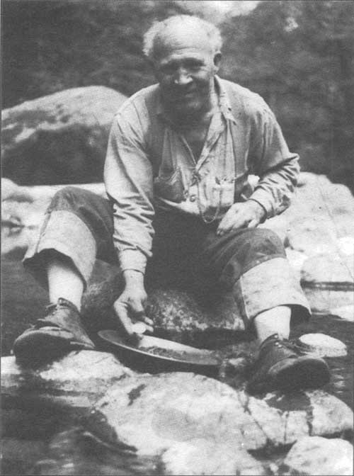
| Mining sometimes led to alleged or actual resource conflicts. Especially during the Great Depression, before the Six Rivers was established, many mining claims appeared to be used as a means of securing summer home sites—particularly on the Siskiyou National Forest's Gasquet Ranger District. Heated debates erupted during this era between miners and the Forest Service. This undated photo shows a miner panning for gold on the Smith River. US Forest Service photo |
|
. . . an angrily-worded petition was circulated in
Del Norte County to remove Forest Supervisor Mitchell from his position.
|
Depression-era correspondence between Siskiyou Forest Supervisor G. E. Mitchell and various Del Norte County residents illustrates some of the pushes and pulls between Forest Service recreation use and mining policies within a context of economic hard times. Following Forest Service actions to invalidate the mineral claim of Harvey Morrell, an angrily-worded petition was circulated in Del Norte County to remove Forest Supervisor Mitchell from his position. Chagrined, Mitchell wrote letters to petitioners with whom he was acquainted, seeking to clearly state the Forest Service position. One such letter was to County Treasurer, Leo Dressier. Mitchell wrote that, by policy and for the greater public benefit, miners could not occupy public land unless their claim contained sufficient minerals for an individual to make a living....
I believe you also know that the miners on Smith River, very few of them, if any, are making a living off of their claims. The relief records in Crescent City show that most of them are accepting county relief. Those that are not are keeping off of that roll almost entirely through the employment with the State highway department or the Forest Service. I believe you will find that if any lands are capable of supporting families from the lands themselves, the forest service will interpose no objection to their using the land for that purpose. We do, however, try to protect the interests of the people by preventing the desecration of these lands....
The tourist business means as much to Crescent City and Del Norte county as any other industry there, and in all probability it will mean considerable more in years to come. Our thought in developing public campgrounds and preserving the scenic beauty along the highway is to encourage more tourists to come. If every available camping spot is taken up by a miner with an old tumble-down shack and a hungry looking dog, its attraction to people who are seeking scenic beauty will be little indeed [Mitchell 1-17-35].
|
"If every available camping spot is taken up by a
miner with an old
tumble-down shack and a hungry looking dog, its attraction to people
who are seeking scenic beauty will be little indeed."
|
In a like letter to a petitioner, Mitchell assured that the
Forest Service is not in any way bothering the miners in Del Norte county... where they are bona fide prospectors attempting to develop the land from a mining standpoint, rather than from a summer home site or a speculative standpoint, with the idea of selling it for such. We have not molested any of the miners along Smith River except those who have filed mining claims on our camp grounds, or who have started an investigation through their criticism of the action that we have taken in the administering of these lands [Mitchell 1-17-35].
Mitchell answered the Regional Forester in a similar vein and added that:
. . . Del Norte county is a small unit unto itself, which is ruled almost entirely by political influence, and whenever anyone has any particular grievance, it is taken to the rest of the people in the community for their assistance [Mitchell 1-7-35].
Supportive of Supervisor Mitchell, Regional Forester C. J. Buck wrote to the Forester in washington, D.C. to explain the actions taken on the Smith River claims—actions that were getting Congressional notice because of complaints from constituents:
We have realized from the start that this situation is full of dynamite, but failure to enforce the usual requirements with relation to mining claims which are obviously held in bad faith will accomplish nothing as I see it, unless to increase the trouble. The supposition that the 'depression' mining locators will gradually abandon the land as its lack of mineral value becomes evident can not hold good for those who put considerable improvements on the claims for living purposes; in fact, the land is so attractive and valuable for recreation homes that the situation which seems gradually to be developing is that even the bona fide 'depression' miner will not abandon the claim until he finds a purchaser for it. The purchaser usually puts his money in the site in the belief that if mining is unprofitable, he will still be able to hold it. . . so that, sooner or later, the claim loses all resemblance to a valid one, and becomes a 'homesite' claim pure and simple [Buck 12-18-34].
Buck also cited his efforts to administratively hold these extraordinarily scenic lands for public benefit and lamented that there was no legal instrument for withdrawing roadside strips and approved recreational areas from mineral location with surface rights. Buck was weary of making recreation plans and administratively removing the land from timber sale or other uses detrimental to those scenic values "only to have alleged miners appropriate the land and turn it to uses incompatible with approved plans." He was sympathetic to poor people's plight brought on by the severe economic downturn, stating his personal opinion that he could not see putting them "out of the national forests as long as the forest is affording them some assistance in the way of a livelihood." But Buck vehemently objected to the speculator who hid his motives behind the mining law, noting that:
Often under such conditions as exist on the Siskiyou, there is little that can be done to combat his claim, and he throws a veil of doubt over the whole scheme of the present mining laws [Buck 12-13-34].
Virtually ignored over the intervening years, by the 1950s, there was renewed concern within the Forest Service that these summer home tracts were "either located in an area of critical fire hazard, in heavy cover at the base of a mountain slope, or are in an area better suited to campground use... on benchlands between the Highway and the river." Moreover, some of the bench land summer homes were in tracts poorly located by the Forest Service. Gasquet was offered as a case in point to illustrate the issues raised. Being located "too close to a center of population," only one of the homes was being used as a bonafide summer home. "The others are used by county officials or businessmen from Crescent City who use them as permanent residences and drive back and forth daily. There is private land available and a townsite is certain to develop" (Beeson 10-5-55: 1-2). More and more, summer homes were becoming primary residences or year-round recreation residences; a situation not envisioned by the early Forest Service. [76]
From Fire Exclusion to Controlled Burns... Yet Another Changing Paradigm
Fire prevention, fire detection, and fire fighting were among the cornerstones of Forest Service responsibilities during the early custodial management days. Though there were occasional heated controversies over the use of fire as a tool, usually referred to as "light burning," few argued with the compelling need to protect timber, watershed, and forage resources from the effects of uncontrolled fire.
|
Early forest officials had struggled with forest
residents and users who were accustomed to manipulating their environment with fire.
|
Early forest officials had struggled with forest residents and users who were accustomed to manipulating their environment with fire. Grazers periodically touched-off fires to promote new, more nutritious vegetation growth and to clear pathways through brushy areas for their stock; miners fired areas they wanted to prospect in order to make the ground and formations more visible and the area more traversable; Native Americans burned areas to encourage growth of preferred foods and fibers and to clear brush from travelways; hardscrabble farmers torched land they wanted to plant. Not surprisingly and with a frequency that disturbed many, these fires far-exceeded their intent. Even when fires performed as desired, as the forests began to be more densely settled and utilized by a greater variety of users, friction increased and the cry for someone to do something about it became louder and more insistent.
The first chief of the Forest Service, Gifford Pinchot was happy to have his new agency oblige. Even before the Forest Service was created, Pinchot had been involved in national studies to calculate what uncontrolled forest fires were costing the nation. A few years later, that foundation gave Pinchot the commitment to make fire a keystone of the Forest Service and a rallying point for its support. Principally written by Pinchot, the original Use Book stated simply:
Probably the greatest single benefit derived by the community and the nation from forest reserves is insurance against the destruction of property, timber resources, and water supply by fire. The direct annual loss reaches many millions of dollars; the indirect loss is beyond all estimate.
Through its watchful fire patrol the Forest Service guards the property of the resident settler and miner, and preserves the timber and water supply upon which the prosperity of all industries depends....
The utmost tact and vigilance should be exercised where settlers are accustomed to use fire in clearing land.... But while the aim ought always to be toward co-operation and good will, it is equally important to have it well understood that [forest] reserve interests will be protected by every legal means [Pinchot 1947:144, 276-279].
|
Dependent on a bright sun, low in
the sky, heliographs relayed fire information from
more remote look-out points to those connected with telephones.
|
National fire figures for the 1920s underlined some of the pressure to maintain or increase Forest Service funding and, moreover, to put more forested land under Forest Service administration. For five years up to 1920, statistics showed that at least 7,500,000 acres of forest burned annually. Not heeding pleas for better slash disposal methods or for fire prevention and control, the total forest acreage burned for 1923 through 1926 was over 23,250,000 acres. By 1927, over 30,625,460 acres had burned. Some advocates of government forestry leveled the blame at what was being called "industrial forestry."
Primitive communication, transportation, and equipment—as well as manpower shortcomings—made forest wildfire protection a daunting deed. Telephone systems were one of the first modern technologies embraced by the new agency and, by the late 1920s, most forests in California had their prime fire lookout points connected to their ranger district headquarters. This was true on the land that became the Six Rivers. Lookout points that were less active or which were simply too challenging to reach with wire used other forms of communication, such as a heliograph. Dependent on a bright sun, low in the sky, heliographs relayed fire information from more remote lookout points to those connected with telephones. For example, heliographs signaled from Lower Trinity back country stations to Brannan Mountain; from there, communications were relayed to the district office over a telephone. Trinity Summit was the main link in the Lower Trinity communications chain, relaying messages to the Lower Trinity Ranger Station—before 1935, near the southern approach to the old South Fork Trinity bridge—via Brannan Mountain (Hotelling 1978: 92).
In 1925, S. B. Show teamed-up with his brother-in-law, National Forest Inspector Edward I. Kotok, to pen a Department of Agriculture Circular that decried fire in the California pine region. [77] In an attempt to de-horse proponents of light burning, Show and Kotok argued that even light fires caused severe damage and loss of valuable trees. They concluded that such fires resulted in decreased growth of residual trees and destruction of seedlings and saplings. Moreover, they believed that fire scars on residual trees were ideal sites for fungus and insect attack as well as making them more vulnerable to complete destruction with subsequent fires. They cited history, saying:
the pioneers, like the Indian, found the forest an obstacle, or at best a source of wood to be used without thought of replacement. To the prospector, the hunter, the stockman of the early days, the best forest was an open one, and fire was the easy means to make it open. So until the creation of the national forests, fires spread year after year largely unchecked. Indeed, the remarkable persistence of forests, in spite of repeated burning, led the early settlers to accept readily the belief that fire not only did not injure the forests, but was a positive benefit.
The mere existence of a timber stand to-day seems proof that fire is no serious enemy; but study of that very stand may show unmistakably the cumulative effect of repeated burns. The presence of fire-scarred trees, an under-stocked stand with less wood than younger but fully protected forests, a lack of seedlings under the mature forest, the encroachment of brush—these are all convincing evidence of the wearing down of the stand by fire.
|
"Where there was but little disturbance other than
grazing activities to the total watershed, now there is much in the way of lumbering, road
building, etc. As a result, free burning fires tend to become
uneconomical because of the risks. . ."
|
Show and Kotok cited fire's ill-effects on watersheds and the consequent increases in run-off and erosion. They acknowledged that light burning could, under extremely controlled conditions, reduce the risk of catastrophic crown fires. But they maintained that, in practice, indirect costs and damage caused by light burning sacrificed part of the values it attempted to preserve and, at best, resulted in only a temporary reduction in fire risk. Show and Kotok charged that the "promiscuous burning" done by ranchers and prospectors "masqueraded under the euphemism of light burning." Instead of its intention being the preservation of forest values, its intention was to eliminate the forest or to replace trees with other forms of vegetation. Kotok and Show concluded that: "Existing difficulties in protecting and managing the forest area—difficulties due to past fires—will increase unless virtual fire exclusion can be put into effect. To build up these run-down properties [subjected to centuries of repeated fires] to their tremendously high potential productivity is the real goal of forestry" (Show and Kotok 1925: 3-5, 11, 15, 18-19). As late as the 1930s, light burning on the national forests was still being advocated, primarily by ranchers. Also, the Great Depression spurred a heightened interest in amateur mineral prospecting and the burning practices that went along with it (Cooper 1939: part III, 60, 61).
Early Six Rivers forest administrators fundamentally lined up with Show and Kotok's point of view. Supervisor Fischer referred to the pioneer history of the area embraced by the Six Rivers as a place were settlement and use was relatively light and, given the area's remoteness, the ratio of the land's timber product values was low in relation to its forage values. Impacts on the watersheds from clearing land by light burning was, likewise, perceived as relatively innocuous, though Fischer noted that their "long range effects are being felt now."
Today, the picture is substantially different. Timber. . . now has real value. . . wildlife and recreation have significant values. Where there were but a few people scattered through the hill lands, owning large tracts, now there are many owning small tracts. Where there was but little disturbance other than grazing activities to the total watershed, now there is much in the way of lumbering, road building, etc. As a result, free burning fires tend to become uneconomical because of the risks to other people, other people's property, and to all the other values [Fischer 1950: 19-20].
By the late 1920s, the Forest Service classified fires into eight causal categories: railroad, lumbering, brush burning, miscellaneous, lightning, camper, incendiary, and unknown. Further, fires from lumbering, railroads, brush burning, and miscellaneous were lumped as "special-risk" fires, being primarily dependent on the presence of "specific fire-using agencies" within a "known restricted area." Believing that industrial users were "devising new methods of prevention and control" for special risk fires, Forest Service researchers in California began focusing on a means of properly budgeting for and allocating fire moneys. They zeroed-in on determining the length of fire season correlated to vegetation type. Moreover, they worked on calculating a reliable average number of lag days between the fire seasons associated with major vegetation cover types. Some research results were that the differences in the length and timing of the fire seasons by vegetation type had implications for designing fire prevention and law enforcement strategies, as well as in locating fire guard stations. The researchers also argued for "far greater development of the present protection organizations" in order to keep fires to acceptable levels of 0.2 per cent of the area burned per year. They argued that the most valuable timber type, the western yellow pine, had a fire occurrence factor five times the acceptable maximum. At that rate, they lamented—using questionable logic—it would only take about 90 years to "burn over the entire area of the type." They urged restocking brush fields with trees where, if protected, they would develop into profitable timber stands. Finally, the researchers emphasized the need to gain quick control of fires by extension of the trail- and road-building programs where fire danger was greatest in order to replace foot travel by horse and horse travel by motor vehicle (Show and Kotok 1929: 13-16, 34-35).
One intent of creating the Six Rivers National Forest was to minimize fire hazards and to decrease the number of larger fires. From 1940 through 1946, the percent of fires that became Class C, D, and E fires for the area that would become the Six Rivers was 9.2; between 1947 and 1949, the percentage dropped to 3.8 (Fischer 1950: appendix table XVIII). From 1950 through 1967, the Six Rivers had 16 fires that were Class E or larger totaling 24,781 acres. The largest was the 1951 Lems Summit fire that burned 7,935 acres. Inclusive of the years 1947 through 1955, 1951 was the worst fire year with a total of 11,529 acres burned; lumbering and lightning fires accounted for the most burned acres (Barnum 9-4-56: 4).
In 1948, a number of fixed point fire detection lookout stations were abandoned on the Six Rivers. The decision to decommission a lookout was based upon whether lightning had constituted the fire history of the land served by the lookout and whether other fire causal risks were low. To shore-up the fire detection gap, these areas were patrolled by contract or Forest Service airplanes after each lightning storm (Fischer 1950: 21). From this time on—with public reporting, aircraft, and satellite detection largely assuming the role formerly played by lookouts—these structures and the men and women who staffed them became an increasingly rare part of the Six Rivers administrative landscape. [78]
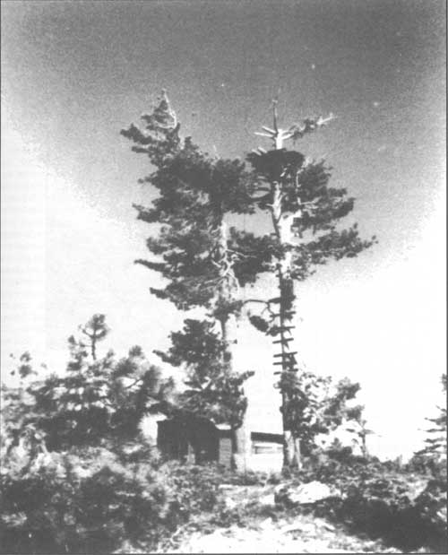
|
| Blue Creek Mountain crow's nest and cabin, Orleans Ranger District. Crow's nests preceded more formal lookout structures. This photo was taken during World War II when Blue Creek Mountain was being used as an Air Warning Service lookout. This lookout no longer exists. US Forest Service photo |
Coinciding with earlier policy, in the 1950s, wildfire prevention and control were viewed as "essential to the successful management of lands of the resources they produce." Objectives for prevention and control were primarily posed in terms of their potential effects on timber values. Fischer defined the Six Rivers' fire control objectives as:
1) To reduce the number of man-caused fires to a practical minimum.
2) To control all fires within the first burning period.
3) To prevent, so far as humanly possible, any fire from reaching Class E size (300 acres or larger).
4) To assure that fires within areas producing or capable of producing commercial timber will not burn more than 0.1 of 1 percent of the area in any one year, or 10 percent in 100 years, the approximate time necessary to grow timber of profitable sawlog size.
5) On watershed areas incapable of producing commercial timber crops, to keep the burned area down to 0.25 of 1 percent per year, or 10 percent in 40 years, the approximate time necessary to produce a fully protective watershed cover.
6) On areas of low erodibility and low value such as the serpentine formation in the northwest portion of the Gasquet District, to control fires therein before they spread to high value areas with due regard to values and costs.
7) To stimulate a similar level of protection on private lands by private owners and/or operators.
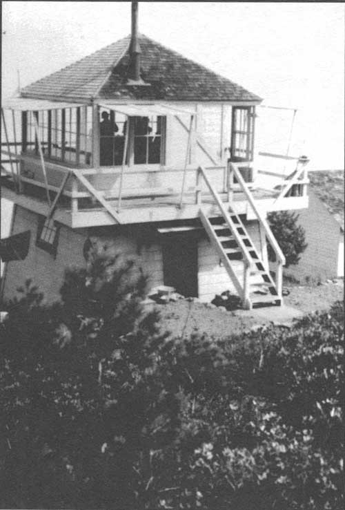
|
| Rattlesnake Lookout, shown in this 1944 photograph, was destroyed by the Forest Service in 1963. It was part of the fixed point fire detection system on the Gasquet Ranger District. US Forest Service photo |
Fischer reflected that the Six Rivers lands had long been considered a low fire hazard because the values were largely not quantified and, compared with other parts of the state, the fire season was short and the fire incidence less frequent. However, the dense vegetative cover, the monumental slash build-up, the challenging topography, and the less-developed transportation system added-up to making fires on the Six Rivers highly resistant to control. Fischer illustrated the normal Six Rivers fire behavior as being comparatively slow in rate of spread, "followed by an accelerating buildup to a point where a conflagration" ensued. With 47 percent of the forest's fires being human-caused and accounting for 95 percent of the burned area, Fischer viewed prevention as a key objective in fire control (Fischer 1950: 17-19). [79]
In 1951, the Six River's protection boundary encompassed 1,129,588 acres, with 199,236 of those acres privately owned. Most of the national forest land was accessible only by trail, and forest records showed that those lands could support "a sustained annual cut in excess of 150 million board feet" (Jarvi 8-852:1-2). The implications were obvious. By 1956, the forest's fire protection boundary encompassed 1,180,877 acres of which 215,007 acres were state and private land. Lumbering and lightening continued to be the cause of most of the acres burned each year, and the accumulated slash and increased use of the forest caused the fire risk to soar. An inspector from the Regional Office declared that the forest's 1956 protection force was "totally inadequate to handle the prevention load or for strong initial attack. Its transportation system, too, was criticized in certain key locales, particularly in the Redcap and Blue Creek areas. Only "luck and some good work in the past has helped hold the average annual fire losses to a reasonable figure." Inspector Baxter sharply reproved the forest's training of its lookouts, complaining: "Most of the lookout maps were incorrectly oriented. Very few lookouts knew how to orient the fire finder" despite their being "interested in their job [and] willing to learn basic fundamentals." Baxter was also bothered by the example he saw being set by the Forest Service, illustrating his point by observations of improperly installed wood stoves at guard stations, fuel break eyesores around Forest Service lookout towers, slash and debris left along the new road construction projects, and apparent laxity in enforcing minimum Forest Practice Act Rules on private land logging operations that were "left as jungles with little if any clean up" (Baxter 8-28-56: 2, 4-6 and Cronemiller and Kern 1949: 24-25).
A harbinger of a different era in fire detection, a board of review's look at the Six Rivers' 1956 fire season noted that, from 1951 through 1955, people other than Forest Service personnel reported 77 percent of the human-caused fires; in 1956, that figure climbed to 80 percent. While reviewers were quick to note that "this does not mean that the lookouts are not doing their job,"—that it was primarily a function of more people being in the forest and reporting fires while they were very small—these observations obviously had implications for reliance on a system of lookout towers as the first line of detection. [80] In the 1950s, the Six Rivers averaged nearly 30 lightning-caused fires each year and experienced a number of blind areas in its detection system. The most pressing problem was that the Six Rivers did not have enough highly trained fire people in overhead jobs to meet off- and on-forest demands (Scherer 1956: 10, 18, 21). The threat of forest fires on the Six Rivers was expressed as a "threat to the North Coast economy." However, the average annual acreage burned over a five year period ending in 1956 was a minuscule 450. During that same period, there had been an average of 29 lightning-caused fires and 19 human-caused fires. The Six Rivers' fire prevention, detection, and suppression force in 1956 numbered 32 permanent employees and 527 seasonal employees, which included six lookouts, 10 patrollers, and five organized fire crews. There were six aircraft under contract for fire purposes and one helicopter. Twenty smoke jumpers and seven air tankers were on-call. The forest had 15 tanker trucks and another seven under contract; it also had 25 bulldozers under contract. From 1951 through 1956, the Six Rivers annually averaged spending $211,000 for fire protection and control (USDA, FS 1957: 6). [81]
By the late 1960s, Forest Service and fire professionals in other land management agencies were implementing programs to restore fire-controlled fires—to the forests to promote a suite of land management objectives. New research showed that the past "Smokey T. Bear policy of stomping out all fires" was having negative effects, and that periodic light fires played an important and positive role in forest ecosystem health. The Forest Service's over half-century old policy of suppressing fires wherever and whenever they occurred was producing a cascading series of detrimental effects ranging from fuels build-ups—that potentiated catastrophic fires—to seriously limiting forage sources and nutritional values for wildlife. Although there were notable breaks with this general fire suppression policy—particularly during the 'teens when some foresters and land managers sought to reduce wildfire hazards by preserving the fire process—"light burning" proponents were drowned-out until the mid-1950s (Kilgore 1970). The 1990s witnessed a full embracement of fire as a land and resource management tool.
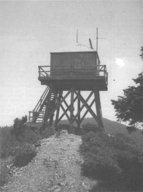
|
| Mad River Ranger District's Cold Springs Lookout was one of several that was, by the early 1950s, used only during periods of high fire danger. Cold Springs also had a hut used as living quarters for an Air Warning Service (AWS) observer, stationed there to spot potential enemy aircraft or incendiary balloons during World War II. Boarded-up when Payne took this photograph for his 1953 GII, the AWS building was slated for removal. US Forest Service photo |
| <<< Previous | <<< Contents>>> | Next >>> |
|
5/six-rivers/history/sec4.htm Last Updated: 14-Dec-2009 |