|
History of Tahoe National Forest: 1840-1940 A Cultural Resources Overview History |
|
CHAPTER V
Era of National Forest Management, 1906-1940
The post Civil War period was an expansive one. Americans rushed to settle vast tracts of hitherto uninhabited land in the west. In 1860 the western frontier of settlement lay near the Missouri River, and between eastern Kansas and the West Coast; there were hardly any white inhabitants except the Mormon settlement in Utah. The decade of the 60s brought homesteads for the farmer and land grants to railroads and institutions of higher learning. In the following decade, Congress offered further incentives to make western lands more appealing through passage of the Timber Culture Act (1873), the Desert Land Act (1877), and the Timber and Stone Act (1878) (Land Planning Committee of the National Resources Board 1935: 60-71). By the nineties, immigrants pushing west into the Great Plains and Rocky Mountain regions and east from California formed a virtually uninterrupted pattern of settlement across the continent. In 1890, the superintendent of the United States Census announced, perhaps prematurely, that the frontier was eliminated. "Up to and including 1880 the country had a frontier settlement but at present the unsettled area has been so broken into by isolated bodies of settlement that there can hardly be said to be a frontier line" (U. S. Census Bureau 1890).
By far, the most influential piece of writing about the west produced during the 19th century was the essay on "The Significance of the Frontier in American History" read by F. J. Turner at the 1893 meeting of the American Historical Association. Turner's "frontier thesis" that America's democratic institutions owed much of their identity to the presence of an area of free land on the western edge of the advancing settlements revolutionized American historiography and has remained provocative enough to generate controversy among historians for four generations. Turner predicted that with the end of a frontier would come major changes in national thought. Among the impacts would be a lessening of cheap resources that would force Americans to adjust their economic, political and daily lives to a new kind of world (Billington 1966: 1-31). In fact, the latter 19th century did bring important new themes to American environmental thought. Chief among these was the belief that science and scientific methods must become the chief foundation on which environmental plans would be built. The image of the land as holding inexhaustible economic opportunity gave way to the vision of technological abundance. New professional groups of conservationists, engineers, city planners, architects and scientists sought a new set of environmental ideals relating to urban, industrial society. Among their shared assumptions was that it was better for society, through the agency of experts, to design and direct the development of the landscape rather than leave the process in the hands of untrained, self-interested men. Coordinated public planning was viewed as necessary to curtail haphazard and exploitative practices common in the laissez-faire approach (Worster 1973: passim).
Establishment of Tahoe Forest Reserve.
The scientific community raised the issue of more efficient management of natural resources long before the progressive politicians made a popular crusade of it in the early twentieth century. Perhaps the single most influential work by an American was George Perkins Marsh's Man and Nature (1864). Marsh graphically illustrated the devastating impact man had exercised on the natural world. Over half of his book dealt with the function of forests as critical agents of soil and water conservation. He recommended that forests be managed scientifically, trees grown on farms, and only mature timber harvested. Marsh's treatise was widely read in America and Europe. He exercised great influence on a few important scientists and policymakers, but his insights and recommendations were only rarely applied in the United States during the nineteenth century.
As early as 1855, the Department of the Interior attempted to stop timber theft from public lands, but local land officers largely ignored timber trespass and local juries were reluctant to convict lumbermen brought to trial. In the 1870s the American Association for the Advancement of Science membership lobbied for Congressional action on forest protection and preservation, claiming that lumbering practices were illegal. No legislation came from the association's efforts, but in 1875 Congress created the Division of Forestry under the Commissioner of Agriculture asking it to prepare a report of United States forest production and consumption. The report, which drew heavily on Marsh's theoretical considerations, set off new interest in forests and led to the organization of the American Forestry Association in 1876 (Steen 1976: 4-19).
Concern for forest conservation and preservation of scenic beauty found expression in several forums in California by the mid-1870s. By that time lumbermen were already making sizable cuts into the giant redwood groves. In 1876 John Muir complained in several newspaper columns and national journals of government inertia in the face of wholesale destruction of the "Big Trees." Concern over clear-cutting Tahoe's forest led a local newspaper to cry out in opposition to the lumber barons who were destroying the "gem of the Sierras."
If in some cathedral there was a picture painted and framed by an angel, one such as mortal art never could approach in magnificance, the world would be shocked were some man to take off and sell the marvelous frame. But Tahoe is a picture rarer than ever glittered on cathedral walls; older, fresher and fairer than any work by the old masters, and yet they are cutting away her frame and bearing it away. Have we no state pride to stop the work? (Truckee Tribune 9/7/1878)
By the 1880s, writers, professionals and scientific groups began to threaten that the country would face a "timber famine" if steps were not taken to stop the plunder and destruction of the country's forests. During Grover Cleveland's first administration (1885-1889) some efforts were made to prosecute land law violations by timber and cattle companies. Denouncing timber frauds in Northern California, the General Lands Office launched investigations that found lumber companies openly using farmers, sailors, and laborers to file under the Timber and Stone Act of 1878, which allowed acquisition of 160 acres of timbered and stony land at a nominal price. The land conspirators would purchase a claim and then immediately re-sell it to the company at a modest profit and go about their other business. General Land Office agents investigating the cases claimed that perhaps three-fourths of the claims filed were fraudulent (USDI, Annual Report 1886: 95, 200-213).
In addition to investigating fraud on public forest lands, Cleveland appointed a professionally-trained forester, Bernhard E. Fernow as chief of the Division of Forestry. Fernow suggested professional management practices and introduced legislation proposed to create forest reserves and the means to administer them. He met with strong opposition in Congress. However, the Forest Reserve Act of 1891 authorizing the President to set aside forest reservations was finally passed as a little recognized rider to a bill whose main purpose was to revise a series of land laws. President Harrison duly created six forest reservations including over three million acres in 1891-92; later he added nine more timber reservations totalling an additional three million acres (Steen 1976: 22-30). Grover Cleveland added five million more acres during his second tern. Included in these early reservations were the San Gabriel and San Bernardino reserves in Southern California, as well as the vast four million acre Sierra Forest Reserve stretching from Yosemite National Park south beyond the Sequoia (Strong 1981: 81). Forest land in the Northern Sierra Nevada remained unprotected.
The 1891 act provided for withdrawal of the forested land but did not specifically deal with administration of the forest reserves. Until management provisions could be devised, the resources on reservations were essentially locked-up. On the other hand, since Congress provided no funds to protect the reserves from plunder, fire, mining or grazing, they probably fared no better than unreserved lands on the public domain.
In 1897, another major piece of legislation, the Sundry Civil Appropriations Bill, passed Congress with unexpectedly strong western backing. An amendment to the appropriations bill authorized the president to modify or suspend or revoke any forest reserve. It stipulated that no reserve should be established unless it would improve and protect the forest, the water flow, and furnish a continuous supply of timber. No lands were to be set aside as reserves if they were better suited for mining or agriculture. Perhaps most significant, the act also gave the Secretary of the Interior the authority to permit cutting and use of timber and stone for firewood, building, mining, milling and irrigation. The timber selected for sale had to be appraised, advertised, sold at or above appraised value, "marked and designated" prior to cutting and supervised during cutting (USDI, Annual Report 1897: CIX-CXIV). The act appealed to some western opponents of conservation because it reestablished commercial access to the national forests; it also paved the way for Gifford Pinchot's resource utilization policies on the national forests.
From 1891 to 1905 the responsibility of administering the forest reserves remained with the Department of the Interior, however, the department turned more and more to the Division of Forestry in the Department of Agriculture for technical recommendations and administrative planning.
Gifford Pinchot succeeded Bernhard Fernow as chief of the Division of Forestry in 1898. From a staff of 123 when he accepted the appointment, Pinchot gradually expanded the Forest Service to an organization of 1,500 people in charge of 150 million acres of forests in 1908. In 1902, E. T. Allen and Pinchot wrote a comprehensive manual issued by the Department of the Interior regarding administrative procedures and policies for the reserves. The two principle reasons for the reserves, the manual stated, were for protection of timber and regulation of water. However, regulations for many other forest-related activities were also addressed.
The manual explained that farming on reserve lands better suited for agriculture was desirable; that prospecting and mining were not prohibited; that roads, trails and irrigation canals could be built by permit only; and that schools and churches could be constructed on public land. Grazing, the rangers were reminded, could be forbidden if damage to the reserve was probable. Regulations prohibited grazing until after it had been shown that no damage would occur. (Steen 1977: 53)
Policies related to grazing and timber management demonstrated clearly that one of Pinchot's obligations was to manage the reserves to the benefit of those living on or near the reserves. Settlers in forest communities were eligible for permits allowing free use of timber. Timber sale procedures provided that "local demand will have first preference." Grazing permits were to be issued individually to cattlemen living in close proximity to the reserve (IBID 1977: 59-60).
On February 1, 1905, President Roosevelt gave final approval for transferral of the forest reserves to the Department of Agriculture. Six months later the Bureau of Forestry was renamed the U. S. Forest Service with Pinchot heading up the agency as Chief Forester. Pinchot immediately began to write a policy blueprint for operation of the Forest Service that was published in a 4 by 7 inch, 142 page volume of regulations and instructions known as the Use Book, designed to fit in a ranger's shirt pocket. Use, the manual made clear, was not contrary to conservation. In Pinchot's perspective, three simple principles governed the management of forest lands: development rather than husbanding of resources; prevention of waste; and development and preservation for the common good (Pinchot 1910: 40-42). Wise use and scientific management for the nation's long-lived material prosperity were the hallmarks of the Chief Forester's philosophy, not preservation for aesthetic considerations or wildlife habitats.
Tahoe National Forest.
Concern over the denudation of timber lands in the Tahoe-Truckee basin had been vocal since the mid-1870s. The State of California took official notice in 1883 when Governor Robert W. Waterman appointed the Lake Bigler [Tahoe] Forestry Commission to investigate the situation in the basin. The three-man commission spent the summer at Lake Tahoe. They discovered that the Nevada side of the lake was largely stripped of its timber while the California side was less thoroughly logged. Of the land in California, roughly one-half belonged to the Central Pacific and the remainder still belonged to the federal government with the exception of selected state school lands and some lakeshore properties belonging to wealthy San Franciscans. The commission recommended that Congress exchange the railroad's lands for lieu lands of equal value outside the basin and then to deed all federal lands to the state "for the purpose of forever holding and preserving it as a State Park" (Report of the Lake Bigler Forestry Commission 1885: 12). The proposals met with opposition in the state senate perhaps because of popular perceptions that the railroads land transfer suggested a "deal" with the corporate interests (Pisani 1977: 12).
In the 1890s, interest in preserving properties in the Tahoe basin once again received considerable attention. Unfortunately by that date the Carson and Tahoe Lumber and Flume Company had completed cutting timber from its tracts at the south shore of the lake and by the end of the nineties large areas in California had been logged. One journalist in 1900 reported: "there has been a dunudation of nearly the entire original forest so far back as it has had a commercial value, from the shoreline of the lake back for 10 or 15 miles" (Bartlett 1900: 247). By the mid-90s, the recently organized Sierra Club, which had been influential in gaining support for the huge Sierra Forest reserve, began campaigning for protection of the forest range in the northern Sierra. The club won support for a 260,000 acre park on the California side of Lake Tahoe from California and Nevada top officials, university faculty, and the Secretary of Interior. The General Land Office sent B. F. Allen, a special forest agent and supervisor, to examine the proposed park. He strongly recommended creation of a National Park (Pisani 1977: 14).
Allen's report received wide publicity in the California press (San Francisco Call 12/24/1897) and the opposition forces quickly mobilized. Local residents and business interests were alarmed, especially vigorous was the protest from El Dorado County residents who petitioned the Commissioner of the General Land Office. The petitioners argued that the proposed reserve would reduce the taxable property of the community, be detrimental to the grazing rights of sheepherders and restrict the private development of fruits and potatoes on land suitable for agriculture. Lumbermen who operated in the Sierra region complained about the reserve as a threat to their jobs and investments (Strong 1981: 82). The Placerville Mountain Democrat (2/18/1898) agreed, noting in an editorial that the reserved land would serve no useful purpose except to become "a shady resort for Forest Comissioners and nonproducing loafers." The Placer Herald entered similar protests intimating that "a sporting organization of San Francisco" had no right to create a game preserve and recreational playground at the expense of the local economy (3/19/1898).
In part to placate local interests, the final proposal of the General Land Office was for a much smaller withdrawal of land, excluding much of the area outside the basin to the west. On April 13, 1899, President William McKinley signed a proclamation for a "forestry reserve and public park" setting aside 136,335 acres, or less than half the area proposed in 1896 by the Sierra Club. The Lake Tahoe Forest Reserve included 55 miles of shoreline and other land in the southwest part of the basin (Pisani 1977: 14). Creation of the reserve did not end the controversy. As events would soon show, concern for watershed protection in the northern Sierra overshadowed interest in protection of limited acreage within the basin. Farmers dependent on irrigation in the Central Valley, John Muir, Theodore P. Lukens and other wilderness preservationists joined forces as champions of watershed protection.
Throughout 1899, leaders of the California Water and Forest Association, the State Board of Trade, the Sierra Club, and other influential organizations pushed for expansion of the Lake Tahoe Forest Reserve (Strong 1981: 33-4). William Mills of the Central Pacific favored including the headwaters of the American River and the western slope of the Northern Sierra in the reserve to assure hydroelectric power and irrigation water to the Central Valley (San Francisco Post 6/21/1899). Charles Wolcott, director of the U.S.G.S., favored expansion. Senator William Stewart of Nevada lent his support for withdrawal of additional lands from public entry as part of a plan to deliver surplus water in the Tahoe-Truckee catchment basin to arid lands in Nevada and to provide hydroelectric power for homes and industries in Reno (Pisani 1975: 129-133, 147-151). Support also came from interests behind the nascant tourist industry at various Sierra alpine lakes who heartily welcomed the enhanced scenic beauty promised by establishment of forest reservations.
Several interest groups objected to the establishment of a Tahoe National Park. The most vociferous opposition initially came from county officials, dairy and stock raising interests, lumber companies and mining interests. These same interests opposed enlargement of the existing forest reserve. Forest Superintendent Charles S. Newhall tried to temper their hostility by explaining that unlike the "prohibitive" administration of a National Park, reserve status would allow for commercial development by regulating and protecting the resources under principles of scientific management. The confusion persisted. Other critics of the bill to enlarge the Tahoe reserve recognized other hidden dangers. Any enlargement would include thousands of acres of land owned by the Central Pacific Railroad, many of which were cut-over or rocky, barren and precipitous land. Lumber companies also owned vast tracts of logged-over land under the Lieu Land Act of 1897, those owning property within the boundaries of a national forest could exchange for land of equal size elsewhere on the public domain. The San Francisco Examiner, in a highly influential article, condemned expansion of the reserve, charging it would result "in the gift of thousands and tens of thousands of acres of the choicest public lands — timber, oil, mineral, agricultural and grazing — to private parties" (2/27/1900).
Forestry agents continued to study the issue of an expanded Tahoe Reserve. Charles H. Shinn inspected the area for the Bureau of Forestry in 1902, noting severe overgrazing and fire protection problems. He advocated expanding the reserve several times its existing size to more than 900,000 acres. The following year Albert Potter, the bureau's range expert, conducted an inspection tour of existing and proposed reserves in California (Strong 1981: 87-88).
The conservation movement of the early twentieth century is most closely identified with Theodore Roosevelt's brand of Progressivism and his shrewd appointments to key positions. The focal point of the Progressive conservationists was land — and the timber, water and grass upon it. The first conservation issues to which Roosevelt devoted himself was irrigation, or the "reclamation of arid lands." In Roosevelt's opinion, the interest of irrigation in California demanded an extension of the forest reserve system. Gifford Pinchot was of the same mind. In 1905 when Congress shifted administration of the forest reserves to the Department of Agriculture, the forests came under Pinchot's charge. With Pinchot as Chief Forester and a president in the White House who actively supported conservation measures, expansion of California's forest reserves seemed inevitable. When Congress repealed the lieu land law that same year, the last blockade to expansion was removed (Strong 1981: 87-89).
In 1905, Roosevelt established six new forest reserves in Northern California: Klamath, Lassen Peak, Plumas, Shasta, Trinity and Yuba. He also greatly enlarged the Tahoe Forest Reserve. Local newspapers did not voice opposition to the expansion. One paper noted that the enlarged Tahoe reserve would be beneficial to the mining interest by furnishing a permanent supply of timber (Mountain Messenger 10/04/05). Subsequently, the national forests underwent many name and boundary changes. In 1906, Roosevelt consolidated the Yuba forest reserve which included lands within the watershed of the forks of the Yuba River, with the Tahoe into the Tahoe National Forest.
Four years later, his successor President Taft, created the El Dorado National Forest from parts of the Stanislaus and the Tahoe National forests. Thus, after 1910 the southern boundary of the Tahoe forest extended to the Middle American and Rubicon rivers. After World War II, lands within Nevada were transferred to the Toiyabe National Forest (U.S.F.S., Proclamation Map Atlas, Tahoe National Forest).
Administration of Tahoe National Forest Lands, 1906-1940.
General administrative programs in office and field had to be set up once the National Forest was created. This task fell to Madison B. Elliott, the first supervisor of the Tahoe National Forest. Appointed as a district forester by Roosevelt in 1904, Elliott had assisted in setting up the basic administrative organization for the soon to be created forest reserves in Northern California. He was an educated man, a college graduate and former principal of the Lakeport School. As with most forest service appointees in those early days, his most important qualifications were his practical experience and strength of character. Elliott was a native Californian, born in 1869 to a ranching family who ran cattle in the foothill and mountain country north of Clear Lake, in Lake County. As a young man he established his own ranching business in the vicinity and for some years operated a sawmill. His major responsibilities in his three years as supervisor were to recruit rangers, explore and map the new forest lands, and initiate the routine business of implementing forest programs (Grass Valley Union 10/15/55).
Mapping and bringing under even rudimentary management the over one million acres in the Tahoe National Forest was a great burden for a small staff. The forest officials dealt first with what they saw as the greatest problems. There were few timber sales in the first few years of Forest Service management. The range offered more pressing problems than the administration of timber resources and Elliott had much success in establishing a cooperative range program with local stockmen. Overgrazing had been a perennial problem in California's forest range so the concept of allotment itself was not debated seriously. Stockmen realized that open ranges required a quota system. Beginning in 1907, Elliott called together stock grazers in the Tahoe National Forest to an annual convention where permits were issued for the following season and general range problems were discussed. The Grass Valley Morning Union reported in 1908 that 230 stockmen attended the second convention, all seeking permits to graze on the National Forest (11/10/08). The interests of the stockraisers were various. Among the issues addressed by Elliott, who served as chairman of the meetings, were range improvements; handling of and caring for stock; building fences, corrals, cabins and roads on the forest; reseeding ranges; poisons and predatory animal reduction; and water development (Morning Union 11/11/08).

|
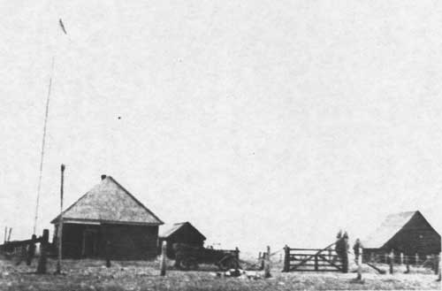
| GOLD LAKE RANGER STATION CA. 1922 |
|
| SIERRA VALLEY RANGER STATION, 1915 |
Overall, Forest Service range policy was favorably received among the stockmen who used the forest for summer pasture. Of sixty-four stockmen polled at the Nevada City convention in 1908, sixty responded that the method of grazing under government regulation was preferable to the old ways (Morning Union 11/22/08). In recognition of his valuable services on the Tahoe, Elliott received a promotion to the regional office in San Francisco as chief of grazing.
Elliott was somewhat less successful in his public relations with the press and local public officials who remained skeptical that the National Forests would accommodate homeseekers, prospectors, farmers and lumbermen. The controversy was touched off by Elliott's proposed western extension of the forest into an area within one mile of Nevada City on the north and two miles to the east. The Banner Hill, Blue Tent, Crystal Springs, Greenhorn Creek and Willow Valley mining districts, as well as the towns of Sweetland, Sebastapol, North San Juan, Cherokee, Badger Hill, Columbia, Lake City, Relief Hill, and North Bloomfield would have all fallen within the boundary of the expanded Forest (Morning Union 11/21/08). The mining interests of the region feared that the large number of unpatented mining claims in the affected territory and sizeable tracts of land open for mining locating would be hampered by governmental restriction. Others argued that a considerable amount of the land was suitable for growing fruit, and therefore unfit for inclusion in a National Forest. In spite of Pinchot's own reassurances published in the Daily Democrat that mining claims would not be affected adversely, Elliott was unable to convince local residents. Acting on his constituent's petitions against the western extension, Congressman Englebright successfully killed the proposal (Morning Union, 11/25/08).
During the long superintendency of Richard L. P. Bigelow (1908-1936), the concept of multiple-use management was introduced as forest officials tried to integrate the functions of watershed protection, grazing, mining and recreational development with timber management and sale. Bigelow began working for the Forest Service in 1902 under Charles S. Newhall, Superintendent of Forest Reserves in California. Bigelow was born in Oakland in 1874, son of a pioneer in the San Francisco fire insurance business. As a young man of eighteen, he left the city for Fresno County where he took up stockraising and ranching until his appointment as forest ranger in 1902 on the Sierra Reserve (Woolbridge 1931: 207-8), While there, he gained experience in fire fighting, boundary line surveys, trail work, timber cruising, issuing use permits, thinning out forests, and regulation of transient sheep grazing on the reserve. Bigelow served as Supervisor of the Trinity, Klamath, and Shasta National forests before accepting a similar appointment to the Tahoe (Grass Valley Union 10/22/55).
Several important personages in American forest history worked on the Tahoe National Forest during the Bigelow years. M.B. Pratt, State Forester, worked as his Forest Assistant; Evan W. Kelly, a world-renowned forester, was a ranger; W. B. Greely, Chief Forester of the USFS, was a scaler, as was DeWitt Nelson, the future Supervisor of the Tahoe National Forest and Director of the California State Department of Natural Resources (Grass Valley Union 10/22/55; Fry 1976). Although many of the management functions during the Bigelow years were custodial in nature, the staff had to delicately balance and develop policies for compatible uses and to deal with constant pressure by special-interest groups, mainly representing timber, water, grazing, and mining. Recreational demand and road improvements were substantially accelerated after use of the automobile became widespread in the 1920s.
By the mid-1920s, power development was one of the chief resources on the Forest as the numerous sites on lakes, reservoirs, and rivers transmitted the hydroelectric power to San Francisco and other cities. Water from the forest also irrigated thousands of acres of orchard lands in the foothills and valley, and was transported to cities for domestic consumption. Commercial timber harvests hovered at about the ten million board foot per year level. Stockmen ran some 13,000 head of cattle and about 100,000 sheep on the forest range lands. With the completion of trans-Sierra state highways came summer home developments, roadside garages, stores, summer resorts, and private and public campsites (Woolbridge 1931: 207-209). During the early decades of Forest Service management receipts from timber sales, grazing permits, recreational leases, and special use permits regularly totaled less than expenditures. The forest was seriously understaffed with just twenty year-round employees and 30 seasonal men employed on the average in 1924. Not until the New Deal planning and programs were instituted were manpower and finances available in quantities large enough to tackle large-scale tasks in a comprehensive manner. Their availability would have a profound, positive effect on professionalism and resource planning within the Service.
To manage the many diverse resources on the Tahoe National Forest compatibly required careful planning, particularly when dealing with long-term ventures such as timber plans or expensive projects such as road building. On the other hand, plans had to be flexible to accommodate abrupt and unexpected shifts in priority. Under Bigelow's administration, plans had been laid out that would be implemented as New Deal monies became available during the 1930s. During this decade a wide variety of physical improvements were made on the forest: ranger stations, lookout towers, telephone lines, roads and trails, and campgrounds (Meggers/Nelson Interview 1982).
The task of implementing the Civilian Conservation Corp and other New Deal assignments on the Tahoe National Forest fell largely on DeWitt Nelson. Unlike the first two supervisors Nelson was a professionally trained forester, but he also worked his way up the ladder within the Forest Service step-by-step. He graduated from Iowa State College with a bachelor's degree in Forestry in 1924. In the spring of 1925 he passed the federal civil service examination for Junior Forester in the U S. Forest Service and was assigned to a position as scaler on a Hobart Mills timber sale in the Tahoe National Forest. The following season Supervisor Bigelow appointed him ranger on the Truckee District. Between 1927 and 1935, Nelson served as assistant supervisor and then supervisor in three different forests in California. He served two years (1935-36) as CCC liasion officer for the 9th Corps Area Military Command in San Francisco, representing all the technical services of the CCC program for the army in ten western states. In May of 1936, he left the liasion post and reported back to Nevada City, this time as Supervisor of the Tahoe National Forest (Nelson Interview 1982; Fry 1976: 15-68). A dramatic rise in the price of gold and the institution of CCC programs had immediate economic and social impacts that were felt in all the communities across the Tahoe National Forest. In addition to the young men from towns and cities who were transferred to working in the healthy forest environment came an equally large number of poverty-stricken victims of the Depression. They squatted on the public lands, took up residence in forest campgrounds, and tried their hand at prospecting for gold to eke out a living until World War II brought employment opportunities elsewhere.
Logging on the Tahoe National Forest, 1906-1940.
Forest Service policy required foresters to exercise balanced judgment in handling timber sales. Chief forester Pinchot set the tone for the conservationist policy of "wise use" and "scientific management" for the nation's long-lived material prosperity. His multiple use concept in the management of National Forests required the protection of watershed and grazing rights to be integrated with timber sales and management. Yet the sales program had to take into consideration local conditions and the structure of the lumber industry. Timber management was to be geared toward stabilizing local industry and benefitting it in the long-run through wise resource planning.
During the first few years of federal management, timber sales were sluggish in the Tahoe National Forest. In order to develop a suitable timber sales program, Supervisor Bigelow instructed his Assistant Forester, M.B. Pratt, to prepare a study of sawmills on the forest. His findings revealed significant changes had been occuring in the industry since the last decade of the nineteenth century. In general, the trend had been away from many small independent mills toward concentration of ownership and vertical integration of the industry.
The first sawmills in the region grew up in association with the gold rush mining camps. They were small mills producing timber for local demand. Pratt reported that on the Foresthill Divide there were eleven sawmills in the early 1850s. The number had fallen to five by 1876, the decrease largely being explained by the decline in mining activity. Only one mill operated on the divide by 1910; however, unlike the earlier mills this one was operated by a large lumber company that owned substantial timber lands and exported its products to outside markets (Pratt 1910: 169).
In the late nineteenth and early twentieth centuries, California lumbermen found themselves caught in a squeeze between rising operating costs and relatively stable prices paid by consumers of their products. Between the late 1890s and World War I, annual cut of pine trees in California nearly doubled. Under the Timber and Stone Act huge tracts of timberland had been fraudulently acquired by large investors who erected large sawmills of 50,000 or more board feet daily capacity. The increase in production prevented significant rise in prices. Meanwhile, the cost of production soared. Logging operations required increasingly complex machinery. Donkey engines replaced oxen in yarding felled trees. In the mills single and double-band saws replaced the old circular saws. These mechanical engineering improvements eventually increased profits, but the capital outlay was tremendous. The initial impact was detrimental as the innovations raised operating costs significantly. According to a 1915 report by forestry expert Swift Berry, the prices pine lumber companies received for their products barely covered the costs of production (Berry 1915: 226).
By 1910, on the Tahoe National Forest, there were only thirty-three mills cutting timber. Of these, twenty-nine were independent firms and the remaining four cut timber for the large mills. Nine mills had a capacity of 50,000 board feet or more. Twenty mills had a capacity ranging from 5,000 to 50,000 board feet, but averaged approximately 15,000 board feet. Of these twenty mills, one-half cut for local demand, five operated in conjunction with mines and ditch companies, and five competed in the marketplace with the nine large mills. In 1910. approximately sixty percent of the land lying within the exterior boundary of the Tahoe National Forest was patented land. Although the vast majority of the timber harvested was taken from private holdings, six of the smaller-sized mills depended wholly upon the National Forest for the timber they cut (Pratt 1910: 169-73).
The large lumber companies responded to narrowing profit margins by restructuring their firms. One response was vertical integration. The mills hired their own fallers and yarded their own logs. Independently operated flumes gave way to company-owned railroads as the chief means of carrying lumber to the mill. Firms that produced only unfinished timber expanded their operations. Large mills operated drying kilns, ran box factories, planing mills, and sash and door plants. Expanded operations allowed them to use poorer grades of pine and white fir. Waste products such as sawdust even found a profitable market. Company officials expanded the size of their firms to take advantage of economies of scale. During the 1910s, reduced profits had caused many small firms to merge or quit business altogether. On a statewide basis, small mills with circular or single band saws cut much of California's lumber in 1900; two decades later, large mills using double-band saws dominated the industry. The number of sawmills fell by twenty percent during this 20 year interval and by 1920 over eighty-five percent of the state's lumber was cut by mills with an annual output of more than ten million board feet (Blackford 1977: 60-73; Pratt 1910: 170).
The changing logging equipment, harvesting methods used by lumber companies, and scale of operations caused timber managers on the Tahoe National Forest to adjust their sale regulations. The Forest, in 1911, advertised for bids on a seventy-three million board feet saw timber sale, providing a ten year period for removal of the timber. It called for construction of twenty miles of railroad line and an adjustment in stumpage costs after a five year period (Pioneer Western Lumberman 1/15/12: 11). The announcement inaugurated an important departure from past policy. The National Forest had large quantities of timber, but it was not easily accessible. Timber purchasers had to make heavy capital investments in transportation facilities to take trees from the stump, to the rail line, and finally to the mill. Under these circumstances only large-scale timber sales requiring a number of years to complete, were attractive to the local lumber companies (Ayers 1958: 33-34).
Until 1911, Forest Service policy was to oppose long contracts. Sales of timber were proportional to existing supply and demand and were designed to encourage sales to small purchasers. The vast majority of the early sales were of this type. Since stumpage prices were rising, forest officials saw long contracts based on current prices as a danger for it might encourage speculation and give unfair advantages to large companies. Prior to 1911, no sales were let for a period extending over five years. Conditions in the lumber industry made the policy impractical. The new plan allowing longer operations with periodic revision of stumpage rates was a useful innovation that protected the public and small operators while opening the forests to the large concerns (Pioneer Western Lumberman 1/15/12: 11).
In 1926, Supervisor Bigelow estimated that in the first twenty years of timber management the Tahoe National Forest had sold and permitted cutting of approximately 185 million board feet of timber, an average of about 9.25 million annually. Timber sales ranged in amounts from a few thousand feet up to whatever amount was warranted considering the investment required for constructing rails or other means of transportation into comparatively inaccessible regions. The Tahoe forest permitted cutting on 14,000 acres of government land in 1925, containing an estimated seventeen million board feet. Bigelow estimated that there were seven billion board feet of saw timber remaining on federal lands. Following the Forest Service policy of marking trees to ensure a second cut within 30 to 40 years, reforestation of the cut-over land would provide timber for future generations (Bigelow 1926: 12).
On private holdings the rate of timber consumption far surpassed that on the National Forest properties. The forest supervisor estimated existing private timber stands at 6 billion board feet in 1925 with timber being cut at a rate of 65 million board feet annually (Bigelow 1926: 121). Except in times of high prices such as during World War I, there was little attempt on the part of lumbermen to engage in scientific forestry practices. "They were concerned with getting the timber out and producing the most profit they could," recalls a Forest Service scaler. By 1910 most of the timber in the Tahoe Truckee basin was stripped off; by then the focus of operating had shifted north into the region north and east of the Little Truckee River and into Sierra Valley. Within 25 years, the lumber companies had denuded their properties. They eventually sold much of their cut-over acreage to the USFS during the depression years as the companies could not afford to assume the heavy tax burden on non-harvestable timber lands (Nelson Interview 1982).
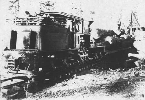
Prior to the 1890s in the pine regions of California, the typical logging operation used oxen to haul logs from the stump to the yard. From this temporary storage area lumbermen transported their timber by raft, river drive, chute, flume, wagon, or railroad to the mill site. Yarding with bull teams was a slow, cumbersome, expensive process. Animals were difficult to maneuver in tight places, or where footing was poor. Where ground conditions were rough or slopes steep, they could not operate at all. If steam power could be utilized for yarding, many problems could be overcome.
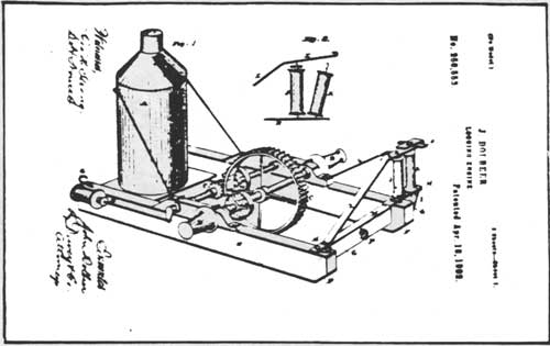
The invention of the steam skidder of the variety used on the West Coast may be found in the granting of a patent in 1882 to John Dolbeer for a "Logging Engine." A seafaring man turned logger, Dolbeer drew his inspiration for the logging engine from machinery commonly used along the waterfront to load and unload cargo between ship and wharf. The original steam donkey contained a small engine with upright boiler and contained no winching drums at all. The machine "featured a horizontal shaft with gypsies at both ends. It had a snatch block fairlead mounted at the head of the frame at one corner to guide the hauling line to the gypsy behind it" (Tooker 1970: 23-24). This side-spool construction proved impractical and the elaborate systems of pulleys required to yard logs reduced the pulling power of the machine. Dolbeer improved his machine in 1883, developing what became the Dolbeer Donkey. In contrast to his earlier machine, this was a capstan type with the vertical spindle-mounted drum driven by steam power (IBID: 24-25).
|
|
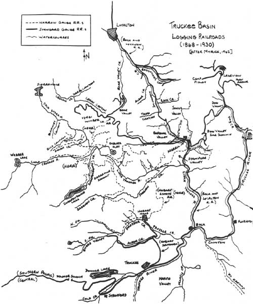
Truckee Basin Logging Railroads (1868-1930) (after Myrick, 1962) (click on image for a PDF version) |
|
| LOGGING ENGINE |

|
| STEAM DONKEY |
Two problems plagued Dolbeer's invention. First, in the early 1880s available steel rope could not stand up to the forces exerted on it in logging operations and snapped too easily. Hemp rope stretched a great deal under strain and manila rope's practical limit was 500 feet at best. Second, Dolbeer's engine still had no storage drum, so the rope had to be coiled and uncoiled manually during yarding. This slowed operations considerably. After 1890 the quality of steel cable improved steadily making it possible to skid logs at a distance of over 1,000 feet (IBID: 27-28). Also in the 1890s, David Evans of the Excelsior Redwood Company near Eureka put into operation the first bull donkey which had three storage drums around which the haul, trip and straw lines were wound (Rutledge 1970: 27).
More powerful machines followed Evan's donkey — all had drums and large vertical boilers. With more powerful engines and reliable wire rope, the donkeys could take over the skidding from the tree falling area to the landing where the logs were loaded on railroad cars. Gradually yarding as a separate operation distinct from skidding to the landing was eliminated.
In his History of Timber Management in the California National Forests (1958: 38), R. W. Ayers describes the typical donkey logging layout as it existed around 1907. The lumber company would start by laying cables along a main chute running up a gulch from one to four thousand feet. At the bottom of the chute would be a bull donkey or road engine. The bull donkey was different than the slack rope skidder (or yarding donkey) in that it did not go to the stump directly but simply hauled logs brought to it by other means. It was the main haul engine, and as such it took the place of trains, flumes, or sled roads. In a small logging operation the bull donkey might be at the mill itself; in operations distant from the mill it was placed at the main railroad with a loading engine.
At appropriate places along the main chute, yarding donkeys were placed to haul logs from the stump to the chute for a distance of 200 to 1,800 feet. The yarders varied in form from merely the bare engine with the necessary pulleys, cables and fittings to a completely portable model assembled on sled skids designed to allow the machine to pull itself along by winching onto stumps or trees (Williams 1908: 15) Close to the yarders would be a swing donkey to take logs from the yarder and drag them through a "frog" or switch into the main chute. Logs were collected in trains at each frog thereby providing a large load for the bull donkey to take down the chute to the railroad or mill site (Ayers 1958: 38).
High-lead yarding which used cables attached to spar trees was introduced to California from the Pacific Northwest. As the rigging was expensive and difficult to set up, only where timber was extremely valuable was this method employed. The high-lead method was not used extensively in California, but where it was found practical Forest Service regulations limited the height on the lead to a maximum of 35 feet so as to minimize scarring the ground. This technique became known as the "modified lead" method (Show 1926: 26-32).
Throughout the 1920s, almost all of the large-scale companies on the Tahoe National Forest logged with donkey engines and railroads. There were some exceptions. The Davies-Johnson, Calpine and Loyalton lumber companies experimented with tractor logging as early as 1924. Of course, the first gas tractors used in California were built for agricultural use in the Great Central Valley. It was not long, however, before they were adapted to the lumber industry. Ayers, in his forest timber management history, implies that tractors were probably adopted first by smaller-scale operators who were still using big wheels and horses in the early twenties. Fuel was cheap and gasoline powered engines cut log handling costs. Furthermore, tractors could log slopes as steep as 30 percent, whereas wheels and horses were limited to 12 percent grades. By the 1930s tractors came into more general use (Ayers 1958: 35-37; Meggers/Nelson Interview 1982).
On the west side of the Tahoe National Forest where sawmills tended to be smaller and produced for local consumption, the men who worked in the mill and Forest were generally settled members of the community in nearby towns. On the eastern side of the Forest where the majority of the logging took place from 1906 to 1940, the situation was quite different. Those who worked in the mills at Loyalton, Calpine, Hobart, Verdi, or Floriston were more likely to be year-round residents of those towns. However, those who labored in the forests, employed on a seasonal basis, constituted a substantially larger floating population. Supervisor Bigelow, in April of 1912, estimated the resident population of lumbermen and millmen within the Forest boundaries at only twenty-eight whereas the "nomadic" loggers almost reached 2,000 (Bigelow 1913: 1). These men lived in the logging camps, temporary forest communities established by lumber companies near the scene of each season's cutting operations. Oftentimes a logger would remain in a camp only long enough to earn a grubstake. "The local people had a saying," recalls ex-supervisor DeWitt Nelson, "any lumber camp had at least three people in it: one working, one coming and one going" (Nelson Interview 1982).
The most successful lumber companies of the twentieth century were those that expanded their operations to include all phases of production, from cutting the trees to producing finished products. Besides handling their own marketing, milling, and manufacturing, these firms took over the production — and often transportation — of their raw materials. This expanded form of industrial operations was necessary in an enterprise whose raw materials came from the ground and where limited resources could be controlled by a few firms. To gain an assured source of supply was essential to the manufacturer.
The three biggest lumber companies on the Tahoe National Forest were vertically integrated firms with substantial land holdings. The Verdi Lumber Company, in 1912, held 14,080 acres in eastern Sierra County. Northwest of its mill site, the Hobart Estate Company owned some 65,680 acres of timberland. The Floriston Pulp and Paper Company's holdings amounted to 32,380 acres (Knowles 1942: 43, 50). In common with the other large mills on the Tahoe National Forest, these manufacturing plants had direct connections to a transcontinental rail system that facilitated broad distribution of their finished products.
|
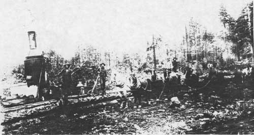
| STEAM DONKEY YARDING, CA. 1900 |
|
| RAILROAD LOGGING ENGINE, CARS; LOADER IN BACKGROUND. NOTE TEMPORARY NATURE OF ROADBED, TIES. |
For about a quarter century, Oliver Lonkey had been active in the Sierra lumber business before incorporating the Verdi Lumber Company in 1900. Since the 1880s, his mills and box factory at Verdi had been supplied with lumber from Dog Valley, first through a long winding flume and later by three-wheeled steam vehicles. About the time Lonkey decided to incorporate the Verdi Lumber Company undertook construction of a railroad into Dog Valley. By about 1905 the company had cut-over all of the Dog Valley drainage. In the final year of operations they cut nine million board feet from their chief camp, Port Arthur, at the north end of the valley (Knowles 1942: 44-45; Bigelow 1926: 10).
Once the timber was exhausted in Dog Valley, the company extended its railroad lines to Long Valley Canyon near Purdy and over Dog Valley Second Summit to Merrill in Sardine Valley. Here it crossed the trackage of the Boca and Loyalton Railroad and pushed on west along Davies Creek into the mountains. In a little over ten years, the Verdi Lumber Company had stripped its vast acreage of all timber:
By the summer of 1912 the company's standard gauge railroad . . . was extended to their timber tracts in eastern Sierra County which comprised an area of 14,080 acres, 9,440 of which they had denuded even to the seed trees during 1912. Two camps were then established to take off the remaining 4,640 acres: Camp No. 1, situated on the line between sections 2 and 3 Township 19 North, Range 17 East and Camp No. 2 in Section 1, Township 20 North, Range 17 East. The bulk of the remaining 4,640 acres lay between these two camps on the rugged land between Merrill Creek and Dog Valley. It had to be logged with donkey engines. The Company finished clearing this during 1913. (Knowles 1942: 45)
Faced with timber shortages, the Verdi Lumber Company purchased the first long-term timber contract from the Tahoe National Forest in 1911 and two years later absorbed the Tonopah Lumber Company and its 40,000 acre timber holdings in Sierra and Washoe counties. Lemon Canyon then became the major site of timber cutting. The company purchased property and timber rights in 1911 and began cutting four years later. Lemon Valley remained the chief cutting site of the Verdi Company through the 1926 season. The firm constructed a railroad spur line into the hills above Bear Valley in 1917. After this area was logged, the company timbermen and railroads branched out westward from Davies Creek into the hills on the south side of Lemon Canyon. Logging continued for five years there and then switched to the north slope of the canyon keeping the railroad supplied for several more years (Jackson 1967: 52-53; Bigelow 1929). On the rail lines laid after 1920 in the Lemon Valley area, the Verdi Company's roads possessed a unique feature, the "Revert Tie":
During 1920 the President of the Verdi Lumber Company, A. Revert, invented a new type of railroad tie, designed to effect considerable saving in timber. The 'Revert Tie' was built from a number of small pieces of timber all held firmly together by a series of wooden dowels. By the spring of 1920 the company was using these ties on its logging railroad. (Knowles 1942: 48)
The sawmill, storage yard, and roundhouse at Verdi burnt in 1926. The company abandoned its mill, sold its remaining timber lands, and tore up the tracks of its railroad. Nearly all the rails were removed and the roadbed abandoned in the summer of 1927 when the Hobart Estate bought the right-of-way to several miles of the old Verdi Company track (Jackson 1967: 62; Myrick 1962: 441).
By the mid-1890s, the Sierra Nevada Wood and Lumber Company had concluded operations at Lake Tahoe and moved its mill to the Hobart mill site seven miles north of Truckee. Equipped with two band-saws and a 52 inch circular saw, the mill had a capacity of about 175,000 feet per day. The new plant also boasted a box factory capable of turning out 9,000 boxes a day, a sash and door mill, a planing mill, and a modern machine shop. A boarding house, dwellings for employees, post office, and a company store were built adjacent to the plant in 1900. In subsequent years, the company added a hotel, school, and express office. Most of the 500 men employed at the mills in 1924 lived in the company town of Hobart Mills. The town remained intact until 1958 (Larder and Brock 1924: 437; Knowles 1942: 47-48).
The company built a standard gauge railroad from the mills to Truckee during 1896 and covered it with snow sheds to allow trains to operate during the winter months. Over this line finished products and sawed timber were shipped to the Southern Pacific main line. The Hobart company operated a small sawmill in Alder Creek in 1901; however, from the time of its establishment at Hobart Mills in 1896 until its winding up operations forty years later, most of the timber company's cutting was done in Sierra County. Demands for sugar pine doors, boxes to ship California's agricultural products, and construction timbers for the Southern Pacific Railroad kept the mills busy. The output of the mills during the period 1900-1920 varied from a high of over fifty million feet in 1906 to a low of twenty-two million in 1918. Annual cuts during the 1920s were somewhat lower ranging from 20-28 million feet (Knowles 1942: 48-49).
From 1909 when Bigelow made the first sale to Hobart Mills to 1936 the company cut some 29.5 million board feet from the Tahoe National Forest, or about three percent of the company's total cut. Most of the Forest's parcels were logged by Hobart after 1917 (Bigelow 1936: 3).
The first line of Hobart's narrow gauge railroad was built up Sagehen Creek to its junction with the Little Truckee River. A second line carried timber from Carpenter Valley down Prosser Creek. By 1917, the company had built twenty miles of track, extending lines into the Independence Creek and Onion Creek Valley. The narrow gauge line from Hobart to the confluence of Sagehen Creek and the Little Truckee was rebuilt to sturdier specifications around 1920. During the following decade, construction was extended to the northeast to Merrill, at Davis Creek, and on north to Sardine Valley, with branches extending in all directions to new timber areas (Jackson 1967a: 34). Ten miles of narrow gauge track were added to the system between 1917 and 1922 when some twelve donkey engines were working to keep the Hobart Mill saws supplied. Many of the roadbeds of the abandoned Boca and Loyalton (1916) and Verdi Lumber Company (1927) railroads were used again by the narrow gauge. Around 1928, Hobart began testing tractor logging. Each year caterpillars replaced some of the mill's Willamette donkeys. The company, in 1934, had six gasoline logging tractors operating on the Tahoe National Forest (Knowles 1942: 49; Myrick 1962: 441). Two years later, Hobart Mills ceased operations. During their forty years of operation they had cut about one billion board feet of lumber. The USFS purchased the cut-over lands of the Hobart Estate Company under provisions of the Weeks Act (Nelson Interview 1982).
In 1899, San Francisco capitalists, funded primarily by the Fleischacker interests, built a pulp and paper mill at Floriston. When the plant was completed the following year it was the second largest paper mill in the United States, and the only such mill in the state. The company owned a 14,000 acre tract of timberland surrounding the plant and controlled an additional 18,000 acres of timberland by 1914 in the region north and northeast of Lake Tahoe and south of the Southern Pacific Railroad. For use in the company's paper mill some 20,000 cords of red fir and white fir were cut annually from these lands (Mills 1914: 679; Knowles 1942: 50).
Whereas the Floriston mill used only fir in its operations, all of the other companies in the region cut pine trees. The paper company worked out agreements to acquire the fir species from the timberlands of other companies such as the Hobart Estates Company and the Loyalton Lumber Company. D. J. Smith cut some 50,000 cords of wood for the Floriston mill from his timberlands in Placer County on Coldstream Creek. The Roberts Lumber Company, in 1909-10, supplied the mill with 20,000 cords of fir from their Truckee and Anderson tracts that had been previously stripped of their pine trees (Knowles 1942: 50).
On the average, the company employed about 150 workers at its Floriston mill and produced from 7,000 to 8,500 tons of paper annually. An Oregon company, Crown-Columbia Paper, bought the mill and its timberlands. Within two years nearly all of its 32,000 acres of timberland were stripped of its fir trees. During an era when other companies were employing steam donkeys and railroads, the logging methods of the paper company appeared very outdated:
They began cutting the logs in October in order that they might season for 6 or 8 months. All trees were cut to a diameter of 12 inches and each tree was cut to a 4 to 6 inch top diameter. The system of winter cutting, however, made it necessary to leave stumps as high as 6 feet so that many cords were thus left in the woods in this form. In summer, or as early as the weather permitted, the cut logs, thoroughly seasoned, were packed on mules or by horse teams and wagons to the company's flume which conveyed them to the mill at Floriston. (IBID: 50)
In 1908, a cooperative agreement was worked out between the Crown-Columbia Paper Company and the USFS to control forest fires on the private and Forest lands being logged by the paper company north of Lake Tahoe and in the Duffy's Camp vicinity. Under the agreement, fire patrols were established on the company lands during the dry season. The headquarters for the patrolmen were in the woods where two-room log and shake cabins were built to provide housing. Between 1909 and 1914 five patrolmen's cabins were built and three fenced pastures set aside to provide feed for the patrolmen's horses. As part of the program, the company and the Forest Service cooperated in constructing fifty miles of telephone line and thirty-six miles of trail to facilitate easy communication with the patrolmen (Mills 1914: 679-83).
The paper company shifted its logging operations to Browns Camp near Soda Springs and to Truckee Lumber Company tracts in Placer County between 1914 and 1921. After exhausting these supplies, the company moved to Donner Lake where it operated a tramway on the south side of the lake to haul wood down the steep mountain slopes to the Southern Pacific Railroad tracks, where loggers loaded the cordwood for shipment by rail to Floriston. Later the company built a standard gauge line north of Donner on Alder Creek and into Evers Valley. The rail line was used in conjunction with the Hobart Estate Company, but was abandoned in the 1930s (Myrick 1962: 442-43; Knowles 1942: 50).
In the midst of Depression hard times, the Floriston mill folded up its operations. The company had exhausted its most readily available timber resources; the mill's efficiency, as well as its output, lagged behind the larger paper mills that had been built in the Pacific Northwest.
Several sawmills operated in the vicinity of Sierra Valley during the twentieth century. Up until 1928, seventeen different sawmills cut national forest timber from the Sierra Valley Working Circle (TNF: Management Plan 1928: 18). The Clover Lumber Company of Loyalton, a subsidiary of the Verdi Lumber Company, purchased the old Marsh mill in 1917. Its annual cut averaged about eight million feet, much of which came from the Badenoch Canyon region. Sardine Valley sawmills included those of Davies, on Davies Creek; Warren near the damsite on the Little Truckee; and Winnie Smith, on the Little Truckee just above Sagehen Creek. The Roberts Lumber Company, the Lewis Brothers California Lumber Company, and several other small sawmills logged along the line of the Boca and Loyalton Railroad, a road built to handle logging operations tributary to their right-of-way (Bigelow 1926: 10-11; Knowles 1942: 46). In 1907, the Boca and Loyalton had at least fifteen short spur lines into the forests where lumber camps had been located. Other spurs ran to the various mills. As the timberlands south of Loyalton were cut over, the Boca and Loyalton declined in importance. With the coming of the Western Pacific Railroad to Sierra Valley, competition for freight traffic accelerated the decline. The Boca and Loyalton operated at an annual loss of $41,000 to $52,000 between 1909 and 1912. Winter shipments were suspended in 1916 and soon thereafter all service on the line south of Loyalton was discontinued (Jackson 1967a: 50).
The sawmill at Calpine was perhaps the largest producer of the Sierra Valley region in the twenties and thirties. The community developed in 1919 or 1920 around the mill and yards of the Davies-Johnson Lumber Company, and was first known as McAlpine. The sawmill and box factory provided almost the entire economic support of the town. Approximately 150 men were employed at the mills in 1934 with an additional seventy-five on the payroll of the company performing other tasks. Much of the finished products from the mill were shipped to distant markets over a spur branch of the Western Pacific which terminated at Calpine. The lumber company closed its mill in 1939. It sold a portion of its property to J. J. Farrar who subdivided it and sold lots to people who incorporated the town of Calpine. The settlement became a vacation and retirement center (Mountain Messenger, Special Mining Edition, 7/29/34; Roth 1969: 8-9).
The logging history of the western side of the Tahoe National Forest continued to differ significantly from that of the Tahoe-Truckee and Sierra Valley regions. The sawmills produced for local consumption, providing lumber for town building, mining sites and other related mining developments. The Marsh sawmill which began production in the 1850s, was still running in 1926. Its logging operation and sawmill moved with the cutters, but its lumber yard remained in the same location near Nevada City where the first sawmill was constructed (Bigelow 1926: 11). The west-side sawmills usually operated on a seasonal basis, closing down with the winter snows each year (The Morning Union 11/25/08). Unlike east-side lumber operations, these companies did not build logging camps in the woods to house cutters. Loggers lived in nearby communities (Meggers Interview 1982).
After World War I, the local lumber business, dependent as it was on the strength of the mining industry, experienced a general state of decline. During the years 1918-1930, the output of gold mines dropped to their lowest point ever and people left the region in record numbers. Not until the mid-thirties did mining recover; when it did, huge orders for building materials arrived at the mills. The Grant and Heether Company of Camptonville for example, experienced sales ten times that of the previous years in the summer of 1934 after Roosevelt lifted the embargo on exportation of gold (Mountain Messenger 6/2/34). General prosperity continued through the war years.
Mining on the Tahoe National Forest, 1906-1940.
From the turn of the century to 1917, gold production statewide rose by about $4.2 million or approximately a twenty-five percent increase. Much of the increase can be attributed to the introduction of gold dredging in the late 1890s which accounted for ninety-one percent of the total amount recovered in 1922 from placer deposits. Since dredging took place in the lower foothill elevations, placer production within the Tahoe National Forest was fairly small. Exhaustion of river placers and stringent limitations placed on hydraulic debris left drift mining as the major form of exploiting the gravel deposits. Lode mining methods had improved significantly in the nineties with the introduction of new equipment; however, with other investment opportunities in California agriculture and Southern California real estate, little outside capital found its way into the deep mines in the early decades of this century (Clark 1970: 4-8).
Inflation following World War I reversed the rising trend of gold production and it continued to decline until the early 1930s. From 1933 to 1935, the price of gold was increased from $20.67 to $35 per fine ounce. The rise resulted in an immediate large increase in gold output and new exploration for the remainder of the decade. Economic conditions in the mining industry on the Tahoe National Forest tended to run, counter that of the rest of the state and nation. The post-World War I prosperity drew workers into California's urban-industrial centers. In agriculture, the war spurred expanded production. When peace came the economy of California had been lifted to a new plateau of production, distribution and consumption of both goods and services. With the price of gold fixed, inflation and high labor costs caused gold production to sink to its lowest level since 1849. Thus, in 1929 at the peak of the post-war boom, gold production had hit bottom (Jenkins 1948: 19).
From a production valued at $9.45 million statewide in 1930, gold output soared to nearly $51 million by the end of the decade. This was the most valuable annual output since 1856. Thousands of miners found new employment in the quartz mines at Grass Valley, Nevada City, Alleghany, and elsewhere (Clark 1970: 7-8). Still bearing millions of cubic feet of auriferous gravel-bearing hillsides, hydraulic mines closed since the mid-80s attracted mining engineers and investors. Thousands of urban unemployed rushed to the Sierra gold fields to prospect with pan and rocker along the various rivers and creeks. It was a movement reminiscent of the "days of '49." The resident population of the communities within the National Forest rose for the first time since the 1900 census. The rise was precipitous — some 42 percent during the 1930s (U. S. Census, Population 1900, 1930, 1940).
The revival of mining infused Forest communities with new life and stimulated non-mining industries such as logging and agriculture. Even a stable town such as Downieville, the county seat of Sierra County, barely survived the hard times of the twenties. Isolated from the outside world and faltering with the failure to attract capital investment in mining, the "somnolent mountain town" was "verging perilously toward the status of a 'ghost town'." With the revival of mining in 1934, the Mountain Messenger reported mining properties long idle were being examined by engineers and that the sleepy town "had suddenly been transformed into a bustling community" (7/29/34).
Under provisions of the 1897 act authorizing management of the reserves, vacant forest land was left open to mineral exploration and location under the general mining laws of the United States. The controlling legislation was the mining law of 1872 which permitted prospectors to enter public lands and stake a claim based on their discovery. The law did mandate that improvements be made on the claim, but did not require the mineral deposits to be actually mined, nor did the miner have to demonstrate the commercial viability of the proposed development. Claims with marginal or no value enabled miners to establish a surface right and with it the right to timber. Strategic mineral locations were sometimes used to control access to forest lands by preemption of the only site for road development (Steen 1976: 295-296).
The U. S. Forest Service permitted bonafide prospecting and mining on national forest lands with the exception of a few mineral resources which we not subject to location. Miners wishing to establish a claim had to file with the appropriate county agency; the Forest Service received no consistent report on the existence of locations in the Forest, nor notice as to whether they were being worked or abandoned. Ordinarily where claims were established, no mineral examination was made until application for a patent was filed. Miners were required to mark the corners of their claim and post a descriptive notice. An initial $500 investment work was required, with the Forest Service reserving the right to inspect the claim for the purposes of issuing a favorable or unfavorable report. If the finding was favorable a patent could be issued. The mining laws required a claimant to submit to county officials a yearly "proof of labor" affidavit stating that at least $100 was spent developing the claim (Friedhoff 1944: 4, 46; Steen 1976: 296).
There were several loopholes in the law which allowed for fraudulent mining claims. Proof of labor certificates were often not recorded, and failure to submit an annual report was not grounds for forfeiture. W. H. Friedhoff, a mineral examiner for the U. S. Forest Service in California with thirty-three years of experience in the field, estimated in 1944 that only about ten percent of mining claims on which proof of labor affidavits were recorded had $100 worth of work been done. Construction of houses, roads, trails, or other non-mining improvements were accepted as patent expenditures. Only in instances where claims were in material conflict with the public interest or interfered with Forest management and administration were they investigated. Where use and activities were not authorized by the mining laws, the validity of the claim was contested. In most cases, the Forest Service won its case against mining trespassers (Friedhoff 1944: 1-4, 9, 46).
Abuses of the mineral laws were common on the California national forests. From 1902 to 1918 lumber companies filed mining claims for no other purpose than to gain surface rights to the timberlands. The Forest Service contested a large number of these so called "sugar pine mining claims" which were particularly rampant in areas adjacent to railroad right-of-ways. After World War I, mountain road improvements provided enhanced opportunities for outdoor recreation. Some of the "gentlemen recreationists" filed mineral claims on which to build second home sites. This remained an on-going problem through the 1940s. During the Depression hordes of migratory small-scale placer miners descended on the forests. These "snipers" presented a major administrative problem, but given the pressing economic circumstances of the times their activities were tolerated. Throughout the period elderly persons and retirees have squatted on the public domain by taking up mining claims as a means of escaping the high cost of urban living (IBID: 34-5).
More than sixty-six square miles of national forest land in California between 1910 and 1938 was patented under the mining laws. Of the claims filed, 81.4 percent were approved. One hundred forty-four locations comprising 3,180 acres were contested. The Forest Service cancelled almost all of the contested claims for reasons ranging from fraudulent use as a homesite or commercial development, exclusive use for agriculture or logging, moonshing, blocking public campgrounds or highway development. Within the Tahoe National Forest the vast majority of the mineral patents on Forest lands were issued prior to 1910. Less than one-fifth of the roughly 30,000 acres of Tahoe mineral patents were issued after 1910. Of the patents granted from that year to 1937, subsequent Forest Service investigations determined forty-eight percent to be used primarily for purposes other than mining (IBID: 5-11).
By the time Tahoe National Forest was established, the lode mining industry had reached a mature stage of development. The mineral areas containing gold bearing ores had already been discovered and more or less explored and exploited. Experienced mining engineers understood this, and instead of prospecting for new discoveries, mine operators and investors focused their talents on improving equipment, reducing operating costs, and improving their capacity to efficiently extract gold from the underground veins. With the rise in the price of gold during the 1930s, mining engineers and prospectors combed the countryside looking to patent claims. With a few exceptions, they directed their efforts to re-opening abandoned mines. Thus, even with the rise in the price of gold, lode production during the Depression was almost entirely from previously established mines.
The lode producing districts actively mining in the early 1900s were centered at Alleghany, Damascus, Downieville, English Mountain, Graniteville, Poker Flat, Sierra City, and Washington (Clark 1970: 19-131). Abandonment of mines in the nineties was forced by crude methods of extracting ore and failure to attract outside investors during that decade of depression. Local mining interests hoped that introducing modern equipment and electric power to the mines would make them once again paying propositions. By 1907, the Grass Valley Daily Morning Union expressed confidence in the resurgence of Sierra and Nevada county mines. People who had previously invested in Nevada's famed silver camps were beginning to look at California gold mines once again. The rejuvination of mining, the paper reported, "is the calm outgrowth of quiet and business-like investigation . . . Wealth is certainly here only awaiting the investment of capital and the application of scientific operation to uncover it" (10/2/07).
There did appear to be some reason for the Union's sanguine outlook in the fall of 1907. The Anchor mine near Graniteville opened for the first time in many years, and the new owners were erecting a ten mill stamp on the property. Eastern and San Francisco investors bought up the adjacent claims in several mining districts and consolidated the existing mines into single ownership. The Hayes brothers of San Jose, owners of the Sierra Buttes mines at Sierra City, organized the Sierra Buttes Water and Canal Company for the purpose of developing water power and generating electricity for their mining operations. Earlier that year the Alaska mine at Pike City was the first mine in Sierra County to obtain electrical power through hydroelectrical generation. The mines in that district were prospering. The Oriental mine, with a large body of paying ore, had plans to erect a new mill the following spring. At the Plumbago, Tightner, Red Star, and Sixteen-to-One the plants were running at full speed. In the entire Alleghany-Forest area, no miners were unemployed (Daily Morning Union 10/4/07, 10/5/07, 10/10/07, 10/11/07).
On a statewide basis peak production during the period from 1900-1929 came in 1915 when $22.4 million was produced by California gold mines (Clark 1970: 4). In Nevada County, the "War Years" from 1914-18 marked the peak of production. In each of these years the county's quartz mines produced over $3 million, a greater total than any year since 1880 (Report of the State Minerologist 1930: 96). By the early twenties adverse conditions were felt severely in these lode mining districts. Many quartz mines in Nevada County shut down completely. Unfavorable labor conditions, the continuing high cost of power and materials, and power shortages that curtailed milling and mining were the major reasons (Report of the State Minerologist 1921: 434-435).
Placer County mines produced little gold throughout the twenties. Only the largest mines weathered the storm. For the first time since 1900, the Nevada County quartz mines' output in 1928 dropped below the $2 million mark. Nearly two-thirds of the gold production came from mines either operated or acquired by the Empire Mines and Investment Company and the North Star Mines Company. Of the remainder, one-half came from the Idaho-Maryland Consolidated Mines, Inc. mines. In the Washington and Graniteville districts, investors made several efforts to rejuvinate former producing properties. Most of these efforts came from small, inadequately financed companies whose efforts in almost every case failed. In the Meadowlake District miners opened 24 claims between 1924 and 1929, but nothing more than perfunctory assessment work was accomplished. Of all the National Forest mining districts only Alleghany, where phenomenally rich ore pockets were being worked at depths of only a few hundred feet, seemed to prosper (Report of the State Minerologist 1930: 96-102; Clark and Fuller 1981: 57-58).
The price of gold on the world market began rising rapidly in 1932 stimulating activity in the California gold districts. Since the world price exceeded that paid by the U. S. mint by almost $10 per ounce, gold exports shot upward causing Roosevelt to institute an embargo in April of 1933. Later that year he relaxed the temporary embargo, allowing sales to foreign markets. Treasury officials foresaw a quickening of mining activity in the western states and predicted an increase in profits of $15 million per year (San Francisco Chronicle 8/30/33).
Within a month mining operators and engineers began appearing in northern Sierra gold towns. Stimulated by high gold prices, rehabilitation work on inoperative mines got underway and the Mountain Messenger (11/4/33) predicted a rebirth of activity in the mountain counties unlike anything seen since the gold rush.
. . . mining is the keystone to the whole situation, for with the influx of people as a natural consequence of the opening of our mines other things will follow. The abandoned hill ranches, with their orchards still intact, which supplied vegetables and produce to the miners would again be made to function; the lumber industry would be stimulated by the building activity that would follow the influx of a large number of people; the dairy and cattle industry would find an ample and ready market right at home, and the resort and campsite business would quickly develop to a degree where it would present a problem to care for visitors.
State Minerologist Walter N. Bradley also noted the immediate increased activity in production, development, and exploration in California mines since the embargo was lifted. "From every county and district, from many sources — the local press, our own field engineers of the State Division of Mines, callers at our offices and personal observation — come reports that men are being added to the payrolls, options are being given, and that mines are being reopened." Bradley predicted that the prosperity would endure for quite some time as many veins and localities had been explored to only a shallow depth. In his opinion, "the surface [was] hardly more than scratched" (Mountain Messenger 1/6/34).
Some rich lode districts within the National Forests such as Alleghany, Downieville, and Sierra City produced continuously through the first four decades of the twentieth century. In many other districts mines that closed down by the twenties reopened in the 1930s. This was especially true of districts such as Emigrant Gap, Graniteville, Meadowlake, Poker Flat, Tahoe and Washington (Clark 1970: 19-131). Whereas during 1917 at the height of World War I production, thirty-four mines on the Tahoe National Forest employed ten or more miners, in 1937 the total had reached fifty-three. In addition, there were some 100 smaller operating mines within the Forest boundary. Combined the mines produced gold valued at over $1.15 million (Bigelow to Shinn 3/20/17; USDA: Tahoe National Forest Facts 1937: 2).
In some cases, mines not worked since the 1850s were reopened. Near Downieville, for example, the Shamrock Mine opened operations at the legendary Shamrock-Mexican Mine. Mexicans had once worked the mine secretly by transporting mule loads of rich quartz down the mountains and steep canyons to their arrastras which were built on the opposite side of the river from Oakley's store at Cox Bar. The mine location was never rediscovered until 1933. To extract ore from the inaccessible mine, the Shamrock Gold Mining Company cut a road one mile through the Forest along the ridge from the City of Six and the Cornish Mine road, and constructed a 700 foot rail tramway down the Yuba slope from the end of their road to the mine portal. Buildings were then erected — a blacksmith shop, compressor house, bunk and cook house, and foreman's house. Compressors and machine drills were installed and gasoline, timber and food supplies laid-in in sufficient supply to keep the mine operating through the winter. One-third mile below the Shamrock, the Blue Jay mine readied for opening in the spring. West of these in Slug Canyon on the trail to Downieville, the City of Six and Triple Pocket mines were reactivated. This flurry of activity was not unique, noted the local newspaper, "many districts surrounding Downieville on all sides . . . are feeling the stimulating effects of the great revival in gold mining" (Mountain Messenger 12/16/33).
By no means were all of the newly opened mines successful. During the Depression, California gold mining attracted a lot of publicity, particularly in papers on the East Coast, where readers eagerly watched for new developments in the California gold fields. The boom attracted some easterners west as it had earlier when mining was the principal industry of the state. Ed Gardner of the California Division of Mines, noted that many new mines were developed by men with no mining experience. In one week in 1934, he visited six mines — one operated by a building contractor from Kansas, one by a manufacturer from Chicago, and a third by an electric furnace man from Pittsburg (Division of Mines 1936: 134). The U. S. Mining Bureau collected records of one thousand old reopened and new mines in California developed by newly organized companies. It discovered that only a small percentage of these operations were successful. Insufficient tonnage of profitable ore, inexperienced or poor management, and inadequate financing were the major causes of failure (Wright 1936: 167-188).
The richest and most famous of the "high-grade ore pockets" to be developed in the California mines was located in the Alleghany District in Sierra County. Ten mines in the Alleghany District produced 57.1 percent of the lode gold in the state in 1937, and accounted for 90 percent of the output of the Tahoe National Forest (Friedhoff 1944: 23, 28). After being relatively quiet in the nineties, rediscovery of the Tightner Vein in 1904 by Henderson L. Johnson led to the revival of lode mining which continued for more than 60 years. Alleghany was the only town in California after World War II where gold was the principal economic base of the community (Clark 1970: 19-20).
Johnson consolidated the Rainbow, Red Star, and El Dorado claims in 1908 with the Tightner and applied for and was granted a mining patent by the Forest Service in 1911. He then sold out to J. M. O'Brien and A. D. Foote, associates of the well-known North Star mine at Grass Valley (Clark and Fuller 1981: 55-56). Foote, a distinguished mining engineer and chief of operations for the North Star Mines, decided to construct a year-round road to link Alleghany with the railroad terminus at Nevada City. The existing road was closed during the winter when supplies had to be packed in and gold carried out by men on skis. The road, a joint public-private venture financed by Sierra and Nevada counties, the U. S. Forest Service and the Tightner mine, was a magnificent engineering achievement. Along the steep descent into the canyon of the Middle Fork, Foote employed skilled Italian, Swiss and Slovakian stone masons to form a dry-laid rock ledge along the precipitous canyon wall. Steel eyelets driven into the canyon wall held the new rock ledge in place (Conway 1980: 11-12).
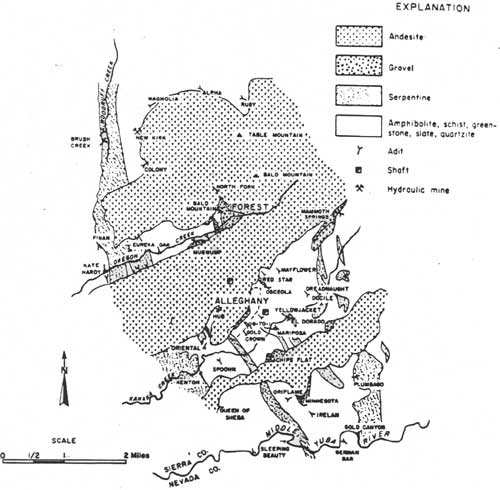
|
| Geologic Map of Alleghany District, Sierra County. The location of mines are shown. After Ferguson and Garrett, 1932, and Carlson and Clark, 1956. (Clark 1970: 22) (click on image for a PDF version) |
Foote and O'Brien operated the Tightner mine until 1918, producing a total of $3 million of ore. Beginning in 1922, a number of extremely rich ore bodies were found in the Sixteen-to-One mine valued at between one and two million dollars. The Sixteen-to-One owners purchased the Tightner mine in 1924 and from then on the operations were combined. These mines together with the nearby Oriental and Plumbago were extraordinarily profitable during the twenties. When gold mining underwent a boom the following decade, hundreds of men found employment in the Alleghany mines (Clark and Fuller 1981: 57-58).
The town of Alleghany was swept by a terrible fire on May 31, 1934, that "almost obliterated the little mountain town." A mining community uncharacteristically known for its population stability and friendly labor-management relations, Alleghany was rebuilt completely within a few months. Much of the rebuilding was done on a cooperative basis with the Sixteen-to-One mine (Mountain Messenger 6/16/34; 7/21/34).
Under the Caminetti Act of 1893, hydraulic mining operations in the Sierra Nevada were made legal; however, a debris commissioner licensed the mines and required them to build debris dams to impound mining tailings. The dams proved in most cases to be a prohibitive expense. In the early 1900s, hydraulic mines still operated in several mining districts on the Tahoe National Forest: Brandy City, Eureka, Indian Hill, Michigan Bluff, North Bloomfield, Pike, Washington, and Alleghany (Clark 1970: 19-131). By the early twenties only three percent of the state's placer yield came from hydraulic mines; drift mines produced five percent and surface placers only one percent (California State Mining Bureau 1922: 48). In 1921, the state minerologist commented on the lack of placer mining activity in the northern Sierra. Most of the hydraulic mines in Nevada County were closed and while there was some drift prospecting, none was producing on an important scale. Placer County reported no hydraulic mining activity in 1920. Pacific Gold Dredging Company dredgers operating on the North Fork of the American River below Applegate accounted for most of that county's gold production. A noted drift mining area, Sierra County production was minimal. "Lack of rainfall, unfavorable financial conditions, and scarcity and cost of labor" had brought drift mining almost to a standstill throughout the Sierras (Report of the State Minerologist 1921: 343, 442-451, 476).
In spite of unfavorable circumstances some hydraulic mining did take place at North Bloomfield in 1927. Several other mines in the vicinity were also producing, among them were the Brockmeyer, Paine Diggings, Sherwood Diggings, and the Dutch Bay Diggings. Two miles west of North Bloomfield the Union Hydraulic Pit was operating as were several other mines that extended "in a continuous series" from North Columbia to Badger Hill. All of these mines sent their debris into the South Yuba River or its tributary Spring Creek (Report of the State minerologist 1927: 110). At Relief Hill and the Omega Placer Mine, hydraulic mining companies experimented with constructing retaining walls at the outlet of old hydraulic mining pits and sending their slackings by flume to be impounded in these locations (Report of the State Minerologist 1930: 131).
All the attention of the debris commission focused on the hydraulic tailings that silted and polluted the rivers and flooded the agricultural lands in the valleys below. No mention was made in the Sawyer Decision of the environmental damage to hills at the hydraulic sites. Vast pits were left behind that attained the proportion of gorges. The huge monitors washed away hillsides where towns and houses once stood. Over the years much erosion has occurred in the pits. At the Malakoff, for example, a great slide took place in the early 1930s that filled the pit to a depth of 70 feet or more (Jackson 1967b: 126). Of all the major methods of gold mining, hydraulicking was the shortest lived, its heyday over by the mid-1880s. Most of the towns associated with great hydraulicking centers have virtually disappeared — Alpha, Omega, Morristown, Forest, Michigan Bluff, Brandy City. When hydraulicking ended, no other industry arose to revitalize the economy of these towns. In only rare cases were the auriferous gravels at the hydraulic sites rich enough to warrant other mining methods, such as drift mining.
Sites similar to those recorded by John W. Winkley could probably be observed at many hydraulic centers on the forest by mid-century. In 1956 he inspected the Great Malakoff wash and left this record:
I drove along the 12 miles of this vast wash and inspected the little towns — ghost towns — of the people who once worked here. The site of Grizzly Hill and the original location of North Columbia have vanished, but ruins mark the spot where Lake City stood. I climbed in and out of cellar pits and foundation enclosures about which grow old locust trees and rose bushes. In one remaining little cabin was a bedstead and stove deep covered with dust. Across the road (once a street) lay the great floor timbers of the Lake City Hotel, once a place of rest and revelry. Along the broad, tree lined main street of North Bloomfield I saw few remaining houses, some in a stately though weatherbeaten architecture of a past age. A few families still lived there. Forest Service, lumbering, road work, cattle and the like keep them busy. (Oakland Tribune 12/2/56)
By the second decade of the twentieth century most of the old hydraulic mining reservoirs were used for irrigation and power purposes. Irrigation districts and power companies purchased the miners' water rights, making it very difficult for hydraulic mine operators to get sufficient water supplies. Although there was some small-scale prospering and intermittent development of hydraulic mines in the thirties near Brandy City, Eureka, Indian Hill, and Michigan Bluff, the output was minimal. Drift mines produced about three times as much gold as hydraulic mines. Among the drift mining districts active in the thirties were Alleghany, Downieville, Damascus, Forest Hill, and Scotts Flat (Clark 1970: 19-131). Power excavators were introduced on the river beds during the 1930s and one of these machines, in 1937, produced almost as much yield as the seventeen producing drift mines on the Forest. As the table which follows indicates, much of the placer gold recovered during the Depression years was taken out by small-scale hand methods and by the "snipers."
Placer Gold Production by Mining Type, TNF, 1937*
| Type of Mining | Number of Sites |
% of Total Production Value (Placer and lode deposits) | |
| Dredges and Power Excavator | 2 | $43,855 | 3.3 |
| Small-Scale Hand Methods | 50 | 23,205 | 1.7 |
| Hydraulic | 8 | 16,205 | 1.2 |
| Drift | 17 | 51,100 | 3.9 |
| Snipers | ca 6,500 | 38,787 | 2.9 |
| *(Compiled from data in Friedhoff 1944) | |||
As earlier mentioned, an interesting feature of Depression era mining on the national forests was the migration of thousands of urban unemployed to the gold districts. These "snipers," both men and women numbering perhaps as high as 20,000, drifted from place to place on the forest mining for gold. As with the original '49ers they could usually be located along the rivers and streams working the auriferous gravels. They rarely remained in any location for more than a few weeks, and often took up residence in Forest Service campgrounds (Meggers/Nelson Interview 1982; Friedhoff 1944: 4).
The infusion of several thousand penniless men and women into the mountains brought some social problems, but they were also viewed as a valuable asset. The Mountain Messenger advocated creating a school for snipers where lessons would be given in "sluice box craft." Old timbers would teach the art of constructing long toms, sluices, or rockers so that snipers might make and spend more money to boost the local economy (11/25/33). Between 1935 and 1937 it is estimated that snipers on the national forests averaged making less than two dollars per day. The surface placer deposits had long been exhausted as far as commercial values were concerned (Friedhoff 1944: 32-33).
Gold was the principal mineral product of the Tahoe National Forest; however, several other minerals including chromite, copper, lead, and asbestos have been produced. Chromite production was very low except during the war years. The Oxford Quartz Mining Company took chromite out of the Downie River - Red Dog Mountain region. It held five patented mining claims, ninety acres of timber claims, and eight unpatented quartz claims from which it extracted 200 tons of chrome ore during 1914-18. The company constructed a cable train on Red Dog Mountain and packed or sledded its ore to Downieville. Chromite mines also operated at Poker Flat, Brandy City and Forest (Division of Mines 1942: 16).
When prices for chromite dropped after World War I, companies were left with a stock of high grade chrome on hand and equipment that could no longer be used. California annual production averaged 161,177 tons from 1914 to 1918. In the interwar years it dropped to below 1,000 tons. Rising prices in 1941 stimulated output to the 2,300 ton per year level (Averill 1942: 70-93).
Much of the asbestos production within the Tahoe National Forest has come since the 1940s from the Sierra City and Goodyear Creek areas, and from mines in Placer County (Division of Mines 1942: 14). The Sierra Asbestos Company operated an open mine pit between 1917 and 1923 and had a milling plant two and a half miles northwest of Washington (Report of the State Minerologist 1930: 91). Many rich deposits of minerals such as iron, limestone and lead existed within the Forest but remained undeveloped because lack of adequate transportation facilities prevented competitive marketing with other producing regions (Division of Mines 1942: 14).
Water Development in the Tahoe National Forest, 1906-1940.
An important factor in lode mining success in the twentieth century was the availability of hydroelectric power which was delivered over a network of high tension transmission lines owned and operated primarily by Pacific Gas and Electric Company. Electrical energy powered hoists, drilling and milling equipment more efficiently and economically and could be used as well for lighting in the mines. The Alleghany and Pike City Forest mining communities were the first to receive hydroelectric power. In 1907, a PG&E predecessor built a 30,000 volt line from its Old Rome powerhouse on the South Yuba River near Nevada City to Pike City. The power was used to replace a steam-electric generating plant, the output of which was too costly and inadequate for deep mining. Four years later, PG&E extended the transmission line for the Middle Yuba Electric Company to Alleghany, a distance of eight miles. Extension of transmission services was soon made to several mining camps in the Alleghany Forest district from the Alleghany substation (Mountain Messenger 7/29/34).
Much of Sierra County remained without adequate electrical power until the 1930s or 1940s. Small hydroelectrical companies the Sierra City Electric Company and the Downieville Electric Company, served those isolated communities. In Placer County the Forest Hill Electric Company, from its plant in Dardanelles Canyon, served that region into the 1920s (Fowler 1923: 73). In 1926, PG&E took over the properties of the Middle Yuba Company and three years later extended service to the mines in the Washington District of Nevada County. In the fall of 1929, Downieville, for the first time in its history, was afforded a twenty-four hour service of electrical energy. Its small water-powered plant on the left bank of the North Yuba which had served the city since 1895 was put out of business (Mountain Messenger 7/29/34; Report of the State Minerologist 1930: 90). As late as 1942, a local power plant served the Sierra City district and most of the county's mines were not served by electrical power unless they generated their own (Division of Mines 1942: 8). Construction of dams and power plants on or near the Tahoe National Forest preceded general electrical distribution to Forest communities by a number of decades. Most of the electrical power initially generated by PG&E facilities was transmitted to urban-industrial population centers of the state.
Incorporated in 1905 as a holding and operating company to take over California Gas and Electric Corporation and San Francisco Gas and Electric Company, Pacific Gas and Electric Company became the most conspicuous example of the tendency toward consolidation manifest in the power industry on the Pacific Coast. The first generating plant built by PG&E was put into operation on the South Bank of the South Fork of Deer Creek in 1908. The main reservoirs of the South Yuba system and a small emergency peak-load supply from the Deer Creek forebay served the power plant. Hydraulic mining companies built the Spaulding Powerhouse. Excavation on the first generating plant began in 1912 and went into commercial production five years later. Spaulding Power Plant No. 2, constructed by PG&E in 1920, generated power from water falling from the Drum conduit to supply the South Yuba canal. The powerhouse was a reinforced-concrete structure built on solid granite foundations in the bed of the Yuba River and was connected to Powerhouse No. 1 by a covered stairway (Fowler 1923: 167-175).
Up until the end of 1913, the Main Yuba Canal was the only conduit owned by PG&E that diverted from the South Yuba, but in that year the Drum Canal was finished and became the principal diversion. Only surplus waters and the minimum amount required to satisfy established water rights were thereafter diverted through the South Yuba and Upper Boardman canals. The Drum Canal headed at Lake Spaulding and passed down the Bear River Canyon. A typical section of the conduit had a base of about eleven feet and a seven-foot depth. Portions of the canal were reinforced with masonry and held in place by dry-laid rock wall on inner banks and a wall of rock laid in mortar on the outer bank (IBID: 176, 187).
Another component of the South Yuba Power development within the forest constructed in the period under consideration here was Lake Valley Reservoir. Originally built by the Towle brothers in 1887 to supply power for pulpmills at Towle, PG&E enlarged the reservoir in 1909-11 to furnished water for the Alta powerhouse. The power company constructed two earth-filled dams with wooden cores at the outlet and a spillway at the south end of a small earth fill secondary dam. The outflow was regulated by agate valve at the end of a tunnel at the east end of the main dam (IBID: 172).
In 1915, a group of southeastern Nevada County farmers and orchardists formed the Irrigation Club, the nucleus of the present day Nevada Irrigation District (NID). The group planned to bring water to a section of Nevada County that was not served by previous quartz or placer mining water systems. In 1916, this group together with Nevada City and Grass Valley businessmen petitioned PG&E to extend its South Yuba Water System to provide irrigation to this unwatered area. The utility company declined, so the club members filed water rights applications on upper Canyon Creek beyond Bowman Lake and for storage waters at Sawmill Lake. PG&E's water rights at that time were still confined to the South Yuba headwaters and to lower Canyon Creek tributaries (IBID: 714-715).
In 1921, the NID launched far reaching plans for headwaters storage development and downstream ditch construction. The irrigation district planned to construct new dams adding headwaters of the Middle Yuba River through a tunnel from Milton to Bowman. The irrigation system of the Excelsior Water and Ditch Company would then be used by the project to deliver water for electric power and irrigation in Nevada and Yuba counties (Bigelow 1926: 14-15). PG&E opposed the plan. It had overbuilt its Spaulding and Bear River power plants anticipating eventually to appropriate the water rights now held by NID. Eventually the two sides settled their differences in an agreement whereby district water was transferred to Lake Spaulding under a power contract with PG&E (Pagenhart 1969: 181).
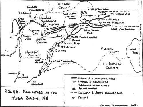
|
| P.G.&E. Facilities in Yuba Basin, 1911 (after Pagenhart, 1969) (click on image for a PDF version) |
PG&E's first major power development on the Tahoe National Forest was the South Yuba and Bear River power system, designed to transfer the headwaters of the South and Middle Yuba rivers to the Bear River Canyon where power could be generated through a series of power plants. The entire system included twenty-seven reservoirs controlled or owned by PG&E, many of which were originally constructed for use by hydraulic miners in the nineteenth century. The first step in PG&E's construction program was the enlargement of Lake Spaulding and construction of the Drum Canal and Powerhouse. The Drum conduit crossed the head of the Bear Valley drainage basin to the south side of the Bear River Canyon and paralleled the old Boardman canal at a higher level.
The South Yuba Water and Mining Company built the original dam at Lake Spaulding in 1892. It was constructed of coarse dry rubble faced on the inner side with three by six inch planks. The new Spaulding Dam, located one-half mile below the old one, was a concrete structure 225 feet high with a thirty inch steel pipe outlet embedded in the concrete. In 1916, PG&E raised the dam to 260 feet and constructed four supplementary dams built into depressions on the ridge north of the main canyon. Called Dams No. 2-5, each of these structures was a gravity section arch dam. These dams were raised, as was the main dam (to 275 feet) in 1919. About 1,000 feet from the main portal of the dam was the original canal and forebay in 1860, they were enlarged in 1907 by California Gas and Electric Company (Fowler 1923: 191).
On the North Yuba River the remaining hydraulic interests combined into an organization known as the Yuba Development Company with plans to construct a series of dams on the river to store hydraulic mining debris, generate power, and provide water for downstream irrigation. The company constructed the Old Bullards Bar Dam on the site of an inadequate debris dam and leased a power plant at the site to PG&E for power development. In 1928 PG&E bought the dam which now lies under the New Bullards Bar Reservoir (IBID: 177-179, 195).
As of 1926, there were no water power developments on the North or Middle forks of the American River with the exception of the hydroelectric plant at Folsom (Bigelow 1926: 15). On the east side of the Sierra on the Truckee River, water developments in the twentieth century were quite extensive.
The Truckee General Electric Company was the first power company to establish itself along the river. It was incorporated in 1899 and built a power plant at Farad to supply electricity to Virginia City that same year. Water was diverted from the Truckee into the Farad Flume by means of a rock-filled timber crib dam at Floriston. Subsequently, four additional power plants were constructed on the Truckee River, all to the east of the Forest boundary (Fowler 1923: 834-843).
In June, 1905, three years after Theodore Roosevelt signed the Reclamation Act into law, the first federal reclamation project opened in the Carson Valley of Nevada with completion of a thirty-one mile canal linking the Truckee and Carson rivers. Several years later the old rock-filled timber crib Von Schmidt dam at the outlet of Lake Tahoe was rebuilt as part of this project. Stone and Webster, a powerful eastern power syndicate which had bought out the Truckee River General Electric Company in 1908, completed construction of the existing concrete dam at Tahoe's outlet in 1913. It was the first major storage reservoir on the Truckee-Carson Project (Pisani 1975: 142, 154-186; Fowler 1923: 841).
The power company, farmers, manufacturers and residents of Nevada towns all had interest in expanding water storage reservoirs in the Truckee Basin. During the 1920s the search for new storage facilities intensified. Government engineers, in 1927-28, surveyed reservoir sites at the headwaters of the Truckee River. They recommended five potential sites north of the river. Stampede and Prosser Creek valleys offered the most likely sites. Lake in 1928, the Truckee-Carson Irrigation District bought the right to store 12,000 acre feet at Donner Lake. The drought in Nevada in 1930 prompted Nevada legislators to introduce legislation to finance construction of a new reservoir on the Little Truckee River, and dams at Webber, Independence, and Donner Lakes. The Bureau of Reclamation killed the bill. Not until New Deal monies became available was a new reservoir built on the Little Truckee at Boca (1939) (Pisani 1975: 228-229).
Water development projects for mining, irrigation and domestic consumption and power generation have been an important part of the history of the Tahoe National Forest. Remnants of many of the early systems still exist on the National Forest others have been seriously altered by adaptive use. In 1937 there were sixty-two dams and twenty-one powerhouses within the Forest boundaries (USDA Tahoe National Forest Facts 1937: 14-15).
Grazing on the Tahoe National Forest, 1906-1940.
By the 1880s, California's range lands were fully stocked and the mountain ranges were in strong demand (Burcham 1956: 277). At the height of the range controversy the forest reserves were established and the grazing problem quickly became one of the most perplexing in reserve management. Theories on grazing and its damage to range lands abounded and often times the problem was addressed by distinguishing between sheep and cattle, rather than treating the problem in its broadest context. Transient sheepmen were often blamed for denuded vegetative cover on the mountains and the consequent watershed problems. Their large bands roamed the country, robbing resident stockmen of what they saw as rightfully theirs. Albert Potter, who would become instrumental in working out Forest Service range policy in cooperation with western ranchers, described the problems of the western livestock business in the late nineteenth century.
In the absence of lawful regulations it was quite natural that the period from 1880 to 1900 should become one of spoilation. The pioneer stockman, eager to reap the fruits of his early efforts, increased herds to the full limits of his ranges. Quick profits, and swollen fortunes naturally lead to speculation and companies were organized to place incredible numbers of stock upon the range. . . . The grazing lands were stocked far beyond their capacity; vegetation was cropped by hungry animals before it had opportunity to reproduce; valuable forage plants gave way to worthless weeds and the productive capacity of the lands rapidly diminished. Class was arrayed against class — the cowman against the sheepman, the big owner against the little one — and might ruled more often than right . . . . Probably no class of men deplored this state of affairs more deeply than did the stockmen themselves, but they were the victims of circumstance and government inaction with no course open to them other than the one they followed. (Roberts 1963: 7-8)
Northern California cattle and sheep ranchers had been grazing their stock on the ranges of future national forests for several decades before the forests began to be created. In the Tahoe National Forest the local cattle business dates back to the gold rush decade. The early ranchers had free, unregulated use of the mountain ranges, just as they did all of the public domain. Competition for grass eventually stimulated demand for control of the public domain by the stockmen themselves. By the early 1900s many progressive stockraisers saw the need for better livestock management, but saw little opportunity for improved practices without some form of range control.
The National Livestock Association (NLA), by the late 1890s, had begun agitating for some effective control of range lands on the public domain. The 1891 act authorizing creation of the forest reserves made no provision for their administration. This aroused unrest and dissatisfaction among stockmen who regarded the reserves a threat to the livestock industry. The Department of Interior, in 1894, forbade livestock within the forest reserves. This ban was later lifted but again in 1897 Secretary of Interior Hitchcock issued a regulation prohibiting pasturing of sheep on all forest reserves, except those in Washington and Oregon (Petulla 1977: 273; Roberts 1963: 23-24).
In 1902 the NLA, unhappy with Interior Department policies, endorsed the policy of administrative transfer of the forest reserves to the Department of Agriculture where Pinchot favored a program of regulated grazing wherein the federal government would play the role of intermediary among sheep, cattle and agricultural interests. The NLA demanded that the department's policy be evolved in cooperation with national and local livestock associations. The National Wool Grower's Association and livestock associations of various western states adopted similar resolutions at their conventions in the early 1900s (Roberts 1963: 18-33).
At a conference of western livestock growers in 1904, convened at the urging of Secretary of Agriculture Wilson, Albert Potter of the Forestry Bureau and stockraisers developed the basic principles of range management on the national forests. The policies, which were to be instituted on the Tahoe National Forest by 1907, included the following points (Barnes 1913: 216-217; Roberts 1963: 44):
1. In granting permits priority in use of the range would be recognized and a preference given to those who had continuously used the range for the longest period.
2. Changes in the numbers of stock grazed and methods of handling stock would be made gradually and with adequate notice.
3. Small owners received preference in allotting permits and were initially exempted from reductions in numbers. Protective and maximum limits were established. The protective limit was generally based on the number of stock which the average settler could care for in connection with his homestead and support his family. Maximum limits set the largest number which persons or corporations were allowed to graze.
4. Improvements in forestry and watershed management would be made, if possible, without total elimination of grazing.
5. Maximum use of forage reserves should be made, consistent with good management practices.
6. Stockmen should be given a voice in establishing management rules in cooperation with Forest Service officials.
The first grazing regulations of the U. S. Forest Service became effective on July 1, 1905. The application of the grazing system took place on the individual forests. Initial tasks included establishing allotment boundaries, apportionment of grazing privileges among individuals and corporations, and adjudication of their differences and those between them and the Forest Service. On the Tahoe National Forest the task fell primarily on the first Forest Supervisor Madison Elliott and his rangers; after decentralization of the Forest Service administration in 1908, Elliott continued to provide considerable assistance as regional chief of grazing.
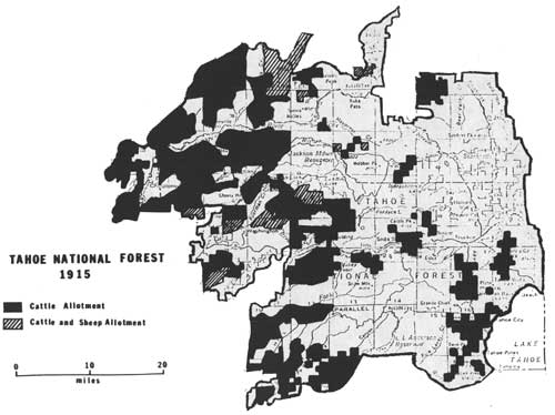
|
|
TAHOE NATIONAL FOREST, 1915 (click on image for a PDF version) |
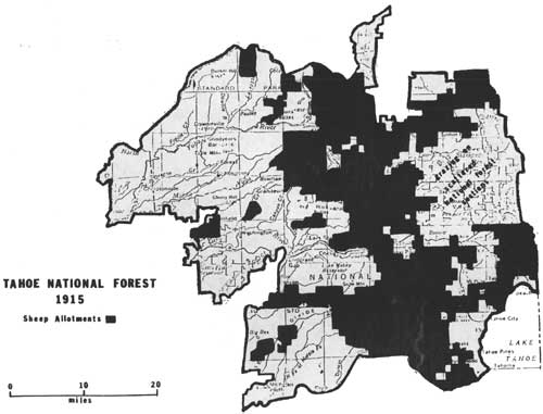
|
|
TAHOE NATIONAL FOREST, 1915 (click on image for a PDF version) |
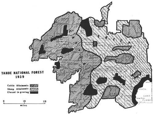
|
|
TAHOE NATIONAL FOREST, 1939 (click on image for a PDF version) |
As in other national forests, the Tahoe forest officials subdivided the Forest into administrative units laid out on the basis of the types of land, the means of access, and the use made of the land. For grazing administration purposes the units were subdivided into allotments which became the basic unit of forest grazing administration. On the Tahoe National Forest allotment boundaries were commonly drawn in conformance with natural landforms such as canyons, river or creek beds, or ridge tops (Meggers Interview 1982). Configuration of allotments might be further influenced by availability of water resources. In certain sections of the Forest a complex interspersion of Forest land with railroad grant lands, mining claims, or other private holdings caused special problems. The early allotment boundaries typically excluded mining districts, towns, and agricultural settlements. However, grant lands of the Central Pacific Railroad on the eastern side of the Forest were heavily grazed in association with the alternate forest reserve lands (Tahoe National Forest Historic Range Maps, 1907, 1915, 1939).
On the Tahoe National Forest, demand for range allotments at first exceeded supply. At the Second Annual Convention of livestock grazers of the Tahoe National Forest, presided over by Supervisor Elliott, 230 stockraisers attended and among the issues discussed were extension of the Forest, regulation of sheep grazing, and establishment of a new reserve with headquarters in Placerville (Morning Union 11/22/08, 11/12/08). Some of the ranchers present came from Forest communities within Sierra, Placer and Nevada counties, however, Yuba and Sutter counties were well-represented as were ranchers from other parts of the Sacramento Valley and the state of Nevada (Morning Union 11/12/08).
Determinations of the numbers of stock for each applicant, and the size and locations of each allotment must have been a difficult task. By 1915, allotment lines were fixed and major changes in the broad patterns of range use did not seem to have occurred through 1939 (Tahoe National Forest Historic Range Maps, 1915, 1939). In the most general terms, the western division of the Forest and scattered allotments at the lower elevations on the eastern side were allotted to cattle ranchers. The higher elevations, and the eastern slope, were assessed primarily to sheepraisers. A Special Population Report prepared by Supervisor Bigelow in 1912, estimated the resident stockraiser population within the National Forest boundary at thirty. Of these, eleven occupied Forest land and nineteen private land. Estimates of the "nomadic grazing population" was considerably higher at 269 (Bigelow 1913: 1). A number of these were, of course, herders, linemen, packers, or other employees of cattle owners. Nevertheless, the implication is clear — most of the grazing demand in the 1910s came from foothill ranches, Sierra Valley, or from areas to the east around Reno and elsewhere in Washoe County. This condition persisted at least into the 1930s (Tahoe National Forest Grazing Plan 1930: 2) and undoubtably remains the situation today.
Reflecting Forest Service policy to allot lands to local residents and long-time users, the early permittees included many pioneer ranching families. Descendants of the Peter Yore family controlled the cattle allotment northeast of Camptonville extending between the North Yuba River and Oregon Creek, east to the Humbug Creek drainage (TNF Historic Range Map, 1915). Peter Yore was a pioneer resident of the Camptonville area, having built the old Sleighville House Inn in 1849 on the Sierra Turnpike. In the 1860s the family built the Yore Toll Road, to improve travel to Downieville. A famous landmark on the road, the inn continued to be owned and operated by the Yore family into the 1920s (Sinnott 1978: 289).
North of Downieville the Lavezzola brothers, descendents of an early Downieville ranching, mining and merchantile family, controlled the cattle allotment on both sides of the creek that bears the family name (TNF Historic Range Map 1915). Rangelands associated with the historic Oak Ranch northwest of Downieville were allotted to Austin Sheehan, son of James, who had purchased the ranch in 1867. The Sheehans lived at the old ranch site until 1917 when they moved to Rackerby. From that time until 1958, they used their ranch and allotment to the north for summer pasture (Sinnott 1978: 292).
Munson Bernard Church controlled several range allotments on the Tahoe National Forest. He possessed a dual cattle and sheep permit on the north slope of San Juan Ridge east of Columbia Hill, and two sheep allotments; one on Poorman Creek west of Gaston, the other surrounding Bowman Lake (TNF Historic Range Map 1915). Church's grandfather, Chandler, came to California in 1850 and was the first settler on the Buckeye Ranch below Indian Springs, Nevada County (Larder and Brock 1924: 1000). Munson and his wife, Kate, who was a grandniece of Commodore Sloat (California's first American military governor), resided on the Buckeye Ranch until 1942 when it was taken over by the government with the establishment of Camp Beale (Sacramento Bee 10/11/46).
The Forest Service granted descendants of the Kelly family grazing rights to rangeland in the vicinity of Cisco. Michael Kelly, an Irishman who had immigrated to the United States at an early age and raised livestock in several southern states, came to Mississippi Bar in Sacramento County in the summer of 1851. During the construction of the Central Pacific Railroad, Kelly took sub-contracts to haul granite from the quarry at Rocklin to places along the rail line. By 1867 his son, Maurice, had taken up cattle ranching and within a decade possessed some 1,200 acres of cattle range in the vicinity of Six Mile Valley (Larder and Brock 1924: 527-528).
On the Truckee District, James Joerger and Sons received grazing rights to the Martis Creek Watershed on the basis of their continued use of that area since the mid-1850s. James abandoned gold mining in 1854 and two years later started a dairy ranch in Clarksville, El Dorado County driving his herd over the summit to the Truckee pasture each summer (Sacramento Bee 4/15/50). Other examples of pioneer families receiving allotments are numerous. The Turner family settled the Fourrier Ranch between Downieville and Sierra City in the 1850s and later ranched in the Sattley area (Woolbridge 1931: 383-384). Permittee A. S. Nichols introduced the first full-blooded Holsteins into Sierra Valley in the 1880s (Sinnott 1976: 260). A pioneer sheep and wool-grower, Albert Eugene French homesteaded on the Bear River area of Placer County in 1870 (Larder and Brock 1924: 525-526). Each of these individuals obtained grazing rights under early Forest Service allotment policies.
Forest Service policies concerning maximum limits on grazing privileges and application of limitations were often complicated by complex individual, partnership, family and corporate interests and combinations of interest. On the Tahoe National Forest several members of the same family sometimes banded together to control large sheep allotments. D. C. and S. H. Wheeler of Nevada held grazing permits comprising extensive acreage west and north of Lake Tahoe extending as far north as Sardine Peak and eastward into Nevada. One of their main sheep camps was in the Kyburz Flat region near a major sheep flockway that cut a large arc south around Sierra Valley. The Jensen brothers held permits for a large percent of the sheep range between French Meadows and Lake Tahoe. Fuller and Sons controlled the range near the headwaters of the North Fork of the American River (TNF Historic Range Map 1915). One of the most prosperous pioneer farming and sheepraising families in Placer County, the Aharts, possessed sheep allotments between French Meadows Reservoir and the Forest Hill Divide at the southern extremity of the National Forest (Thompson and West 1882: 386). The Fuller and Ahart families had been running sheep in Placer County at least since the 1870s. Price Blackford and his partner brother-in-law Joseph Hartley held permits to run sheep over much of the area north of Highway 80 between Cisco Grove and Donner Summit, including Fordyce Lake and Lake Sterling. Blackford was born in Grass Valley in 1855 and spent much of his youth hiring out on dairy farms in the mountains. He established his home ranch in 1875 in Yuba County in the vicinity of Wheatland (Delay 1924: 433-434). In 1907, Blackford and Hartley were grazing 5,000 head of sheep on their summer pasture lands (Dairy Union 10/2/07).
The average size of cattle allotments on the Tahoe National Forest by 1915 was substantially smaller than sheep allotments and the cattlemen were more numerous. There does not appear to have been any attempt by these small cattle owners to form group organizations for cooperative handling of livestock. As indicated above, sheepmen often combined the herds of several family members into a cooperative partnership that in some cases extended beyond the immediate family. As of 1915, however, there was only one sheep association or company holding grazing allotments on the Tahoe National Forest and it was by far the largest single permittee. The Pyramid Land and Stock Company, a Nevada sheep-raising outfit, grazed their stock on both sides of the Bald Ridge Divide, along the headwaters of the Middle Yuba River and the Little Truckee River; in the mountains west of Sierra Valley at Gold Lake; and on the Bald Mountain Range east of Loyalton. This Nevada-based company, together with the Wheeler brothers, owned grazing rights to perhaps one-third of the National Forest's sheep allotments in 1915 (TNF Historic Range Map, 1915).
Once range allotments were laid out and disputes over grazing rights settled, efforts in management were directed toward range restoration through improvement in the manner of handling livestock. In 1905, Albert Potter argued before the American Forestry Congress that his investigations of the forest ranges indicated damage caused by livestock was most often attributable to grazing too early in the season and poor handling of stock. Lack of range management was as significant a contributing factor to range destruction as overstocking. In the sheep industry most grazing practices were based on lowest cost of operation. Forest Service management changed some herding practices. Close herding of stock caused much damage to forage and was eliminated, as was long use of bed grounds. Prior to about 1910, herders usually established semi-permanent camps in the center of their range area and herded sheep back to the same camp each night. Thus, bed grounds were denuded and trampled into dust. The Forest Service set limits on the number of days sheep could be bedded at any spot, initially six days; later this was reduced to three. The Forest Service alternate method of herding sheep, known as open herding, which minimized driving and allowed sheep to spread out and graze, resulted in smaller flocks. Whereas herders could drive 1,200 to 2,000 ewes with lambs and 2,000 to 3,500 "dry" sheep under the old system, open herding cut the size of flocks in half (Roberts 1963: 99-101).
On cattle allotments the Forest Service range policy also led to some changes in historic methods of operation. Cattlemen had for many decades established small homestead claims in the mountains where they built small cabins and fenced meadowlands to feed the horses of cattle tenders. With the establishment of allotments care had to be taken to keep stock from straying. Drift fences reduced the time cattlemen spent riding to retrieve wandering cattle, kept cattle within assigned allotments, and prevented unassigned stock from entering. In the broken, mountainous sections of the Forest, boundaries often were drawn along creeks or precipitous slopes which largely precluded the need for fencing (Meggers Interview 1982; Roberts 1963: 101-104).
The Forest Service instituted measures similar to the open herding policy on sheep ranges to cause cattle to distribute themselves and graze all over the range with minimum driving. Cattle were drawn to salt licks located in lightly grazed areas. Water developments, especially piping of spring water into troughs and ponds improved distribution. Programs of predator eradication were worked out with stockgrowers as wolves, coyotes, mountain lions and bears destroyed great numbers of livestock each year. Stockmen associations offered payment of bounties, and hunters established cabins in remote areas which served as headquarters for their operations. The Forest Service assisted in predator control and also instituted programs to control poisonous plants and infectious diseases (Barnes 1913: 226-347).
Wartime demand increased the number of livestock permitted on all national forests from 1914 to 1918. The need for meat and wool increased so radically that the Department of Interior opened the national parks to grazing for the first time. Overgrazing had disastrous effects on the range and much attention was given to reduction in numbers during the 1920s. Sheep took an especially heavy toll on grazing land on the eastern district and the National Forest purchased 20,000 acres from the Sierra Nevada Livestock Company to help eliminate further destruction to timber lands. Supervisor Bigelow planned to eliminate as many sheep as possible replacing them with small numbers of "locally owned cattle" (TNF Management Plan 1928: 19).
Following the war, depression hit the livestock industry, prices for wool and meat dropped quickly and the adverse conditions lasted well into the 1920s (Roberts 1963: 121). Between 1926 and 1930 the numbers of cattle grazing on the Tahoe National Forest dropped by thirty percent, sheep decreased by twenty-five percent. The numbers of sheep continued to drop throughout the thirties, in part because of Forest Service policy, but also because of difficulty in obtaining trustworthy, competent sheepherders.
Livestock Permitted on the Tahoe National Forest*
| 1926 | 1930 | 1937 | |
| Cattle | 13,000 | 8,985 | 11,650 |
| Sheep | 100,000 | 75,507 | 65,780 |
| *Bigelow 1926: 6, 1930: 2; USDA, TNF Facts 1937: 11-12. | |||
Basque sheepherders had become indispensable to large stockowners by the 1900s. With the Basque, however, sheepherding was seen as a way to establish their own herds, then sell out, and return to Europe to set up their own business. In the 1920s, immigration restructions setting a low quota for Spanish nations caused a severe shortage in the sheepherding industry which reached crisis proportions. It never fully recovered (Douglass 1980: 59-61).
Recreation on the Tahoe National Forest, 1906-1940.
Mountain people in the early years balanced hard work in the mines, mills and logging camps and hard living conditions with recreation. Excursions on horseback, fishing, hunting, and relaxation at mountain resorts were favorite pasttimes. The mountain resorts at Lake Tahoe and Webber Lake, Coleman's and Freeman's resorts near Gold Lake, fishing at Donner and Bowman Lake, and Campbell's Hot Springs were major attractions. Counties and cities competed in winter "showshoe" races and annual Snowshoe Race Tournaments were held at Alleghany Forest, La Porte, Sierra City and elsewhere throughout the region.
The late nineteenth century brought a surge of interest among Californians in primitive environments for the purposes of recreation. Wilderness camping and mountain climbing were important aspects of this movement and had a special appeal to city people as temporary relief from artificial constraints, the frantic pace of urban life, and the tyranny of the clock. A form of medical treatment known as the "wilderness cure" enjoyed considerable popularity in California during the late nineteenth century. Such patients under the advice of physicians abandoned normal domestic life for a relaxing outdoor camp existence far removed from settled areas. Physician H. Gibbons described the treatment in a California medical journal in 1876:
'Camping out' is getting to be a common practice with invalids. A party is formed, and some mountain nook or other desireable spot is selected, where, with tents and simple bedding and cooking utensils, the company spend their time in fishing and hunting, and recreation of all kinds; and if happily they possess the intellectual means, in the practical study of the charming Book of Nature. (Quoted in Thompson 1976: 145)
Although medical climatologists considered the Coast Ranges "the acme of wilderness perfection," the Sierra Nevada also received high marks (IBID: 155). Believing that the high mountain air and pure waters of Lake Tahoe possessed special therapeutic qualities, Dr. Charles Bourne of San Francisco established the first health resort on the shores of the lake in the 1870s at Carnelian Bay (Bourne ms).
By the early twentieth century, appreciation of the wilderness had become a national cult, and perhaps nowhere held more national appeal as nature's wonderland than did California. The Central Pacific Railroad provided easy access to the high mountain country of the Sierra from Northern California's major urban centers. With a favored location adjacent to the railroad, the Truckee-Tahoe area became a focal point of early mountain resort development. As mountain roads improved, recreation grew along main traveled routes. By the late 1910s the Lincoln Highway passed through Truckee bringing hundreds of automobile parties to camp on the shores of Donner Lake during the summer months (Grizzly Bear 6/18/18: 2) During the 1920s, Sierra County and the Forest Service, under cooperative agreements, improved and widened State Highway 49 over Yuba Pass. That road was oiled for the first time in 1934 making it possible to travel by automobile from Sierra Valley to San Francisco on a hard surface highway. "Gone forever are the dust clouds," boasted Downieville's newspaper, "forgotten are the tortuous curves . . . nothing remains to remind the motorist of them except an occasional grass-grown glimpse of the former roadbed as he rolls along the newly surfaced highway." That same year the connecting road from Sierraville to Hobart Mills was scheduled for paving and oiling (Mountain Messenger 6/3/34). Completion of this roadwork made high speed automobile travel possible from the Sierra County towns along Highway 49 to the Victory Highway via Sierra Valley.
It is difficult to overestimate the geographic, economic and social impact of the automobile revolution on mountain communities within the Tahoe National Forest. Perhaps the impact was felt as early as 1915. By that year, roads were sufficiently improved to allow Superintendent Bigelow to travel by automobile when carrying out his duties on the Forest (Bigelow 1917). Not only was the car a back-to-nature tool for affluent urban dwellers to escape a disturbing urban environment, it modernized rural mountain life. In multiplying the number of miles one could travel in a day, the car upset a variety of traditions that depended on smaller, horse-bound spatial radius. Over time, the car substituted a more regionalized network of road-oriented consumers for the older, more localized community of land-locked producers.
The railroad, improved roads and access to mountain lakes and other camping sites made the Tahoe National Forest a popular recreational playground. In 1905, there were numerous private summer resort homes around Lake Tahoe and some twenty hotels. An estimated 40,000 people visited the lakeshore resorts that year (Truckee Republican 9/27/05). The big building boom in summer resorts was just beginning. In 1900 no more than 100 individuals and companies owned property at Lake Tahoe. This changed once the Southern Pacific took over the spur line between the lake and Truckee and popularized the lakefront resorts. Passenger streamers transported tourists about the lake. In the 1910s and 1920s the automobile and cheap gas made summer homes increasingly accessible as well as fashionable. By 1930 the number of lakeshore property owners had jumped to 2,000 (Pisani 1977: 17).
Many of those who owned property at Tahoe hoped to preserve their mountain retreat as a hideaway for California's and Nevada's affluent social elite. Fears that capitalists who owned most of Donner Lake's shoreline would forbid public camping led, in 1911, to a movement "to make Truckee and Donner Lake the great camping region of the common people of California." W. B. Gelatt owned a large tract of land along Donner's north shore which he offered to subdivide and sell to "poor men" in small parcels upon which a "tent, bungalow or summer cottage" could be erected (Truckee Republican 4/5/11). Sales were sluggish in spite of his efforts to attract buyers by offering gift lots to the first applicants. Eight years later, Gelatt launched the first comprehensive plan to make Donner Lake into "California's greatest winter and summer resort." Known as "Donner Lake Camp," the working-man's resort consisted of a "large camp of housekeeping tents completely equipped and electric lighted'; sanitary, electric lighted campgrounds for automobile parties; an up-to-date grocery; restaurant; and a large dairy." It boasted of boating facilities; summer hunting, fishing, swimming, hiking motoring, and horseback riding; winter sleighing, tobogganing, skiing and snowshoeing. In addition to the public campground facilities, Gelatt offered individuals opportunity to purchase a limited number of camp and bungalow sites for $95.00 per lot (San Francisco Examiner 4/24/19; 5/3/19). For railroad passengers disembarking at Truckee, Gelatt offered a stage service to the resort in a coach driven by his father between Placerville and Virginia City during the Comstock boom (San Francisco Chronicle 8/31/19).
In the automobile age, these types of commercial campgrounds became the poorman's summer resort, the cheapest place to spend a family vacation. By 1926 an estimated one-quarter of a million people visited the Tahoe National Forest for recreational purposes. The main attractions were Tahoe, Donner and Independence lakes which were filled to capacity each season. The North Fork of the Yuba was also becoming a popular area for summer resorts, especially those in the vicinity of Goodyear's Bar, Downieville, Sierra City and Gold Lake (Bigelow 1926: 16). The Sierra County lakes region boasted a number of popular resorts with fishing, swimming, boating and lodging available. Among these were Salmon Lake Resort, Lakes Center Camp, Packer Lake Lodge, and Camp Pioneer at the Yuba Pass (Mountain Messenger 7/29/34).
Just as the wealthy nineteenth century magnate had built palatial summer cottages in the fashionable resort centers, middle class folk in the early decades of the twentieth century bought up abandoned homesteads or farmhouses for conversion into summer homes. Most were probably primitive cabins, on the order of contemporary hunting shacks. After World War II, cottages were better built and equipped and winterized for year-round use as genuine second homes.
Skiing, the most popular outdoor winter sport in the United States, did not really catch on in this country until the 1930s, when an ingenious Yankee mechanic in Vermont hitched a thick rope to an old Model-T engine and invented the rope tow to haul skiiers back uphill. In the forest communities of the Sierra Nevada, skiing was a way of life during snowy winter months and ski tournaments were an event of immense cultural/recreational significance to the local populace. The Auburn Ski Club developed the first commercial recreational ski resort in the Sierra just below Cisco on Highway 40. Ski areas quickly followed at Soda Springs, Sugar Bowl, and elsewhere along the main highway and railroad tracks where winter access was possible (Meggers/Nelson Interview 1982; Fry 1976: 24).
Increased automobile traffic stimulated by winter and summer recreational developments promptly engaged the attention of private capitalists to the business of accomodating highway travelers. Business competition centered on improvement of campsites, service stations, stores, and "soft drink stations" (Bigelow 1926: 19). The motel industry was born and with it other facilities for those able to pay in what one auto camper called "hoboing delux" (Belasco 1979: 4). By the late 1930s, trailers had become very popular on the roads and with them the auto vacation increased in popularity while promoting at the same time the development of trailer camps. Almost all of the early concessions and stopping places developed along Highway 40 were destroyed when the new trans-Sierra Highway was built.
Forest Service Recreational Developments.
In 1905, Forest Service recreational policy consisted of little more than fish and game regulations, trail marking and road building to enhance access for a public interested in "getting back to nature." Early recreational policy looked to uses that could generate income through special use permits for resorts and summer homes. From 1906 to 1914 Forest Service policy discouraged private investment in recreational improvement of Forest lands through its system of issuing annual permits subject to cancellation at the end of each year. The "Term Permit Act" of 1915 substantially changed Forest Service policy authorizing issuance of long-term permits of up to thirty years. The change in regulations stimulated an increase in second home construction on the California national forests that lasted until the Depression. The national forests charged a fee ranging from $5 to $15 per year, depending on its remoteness from urban areas. Lot size was limited to a maximum of one-half acre and permittees had to demonstrate minimum improvement expenditures and complete approved construction within a specified time period. "Lieu taxes" paid on these residences became an important source of revenue to the counties (Berg 1976: 84-108).
Under provisions in the Term Permit Act, forest rangers had responsibility for locating and surveying recreational sites and exercising controls over their developments. Of the summer home tracts existing on the California national forests in the mid-1970s, 16.5 percent were surveyed in the first five years of the program, 53.6 percent during the 1920s, and only 17.5 percent during the economically troubled decade of the thirties. Between 1915 and 1933, California national forests granted over one-half of the total special permits issued for summer home construction (IBID: 83, 90). On the Tahoe National Forest, rangers surveyed four summer home tracts on Bowman Lake in 1926 and several lots were bought immediately. Tracts at Ramshorn Creek and the North Yuba River near the highway were laid out the following year, as were parcels on Lake Tahoe at Cedar Flat near Carnelian Bay on the Tahoe City-Brockway state highway (Bigelow 1926: 19). In 1937, visitor days by summer home users on the Tahoe National Forest were estimated at 6,200 (USDA, TNF Facts 1937: 3).
Realizing the growing attractiveness of the mountains for recreation, the California National Forests began to advertise its recreational attributes. The USFS, in June of 1915, published a guide to free, unrestricted camping on Forest lands entitled Handbook for Campers in the National Forests in California (Bachman 1967: 2). At this time, recreation was seen as a non-commodity use of the National Forest, and therefore was assigned a low priority. In 1916, President Wilson created the National Park Service in the Department of Interior. Stephen T. Mather, chief of the new agency, had been attracting substantial attention to the parks as recreational areas for the newly motorized American wilderness enthusiast. The Forest Service was threatened with additional transfer of its forest land into the growing park system as the public placed increasing value on wilderness preservation and outdoor recreation. Thus, by the late 1910s, new concepts about the non-productive values of the national forests were challenging traditional utilitarian objectives (Steen 1976: 116-117; Nash 1967: 184).
In 1917, the USFS commissioned landscape architect Frank A. Waugh to conduct a study of the recreational potentials of its forest lands. Waugh toured the nation, inventorying the recreational resources in the national forests. He recommended that sightseeing, camping, and hiking be given equal consideration with economic criteria in forest land management planning (Nash 1967: 184). The USFS established a Branch of Public Relations in 1920 "for more careful planning of methods by which the public interest may be increased in both the protection and use of forests" (Steen 1976: 162).
The Forest Service allotted $2,000 in 1922 to California campground development. It was the first such payment and within two years cabin, campground and picnic sites had begun to be designated and developed. The period from 1925-1932 was a period of experimentation. Recreation expert Dr. D. P. Meinckee advocated designated trails and parking areas to be included in campground designs in 1928; four years later he urged construction of improved campsites with fixed fireplaces and tables, barriers to control automobiles and sanitation facilities (Bachman 1967: 3-4).
During the Depression, use of campground facilities in the national forests increased significantly because camping was a cheap means of vacationing. Estimated visitors at Tahoe National Forest campsites in 1937 was 4,900 (USFS, TNF Facts 1937: 3). In addition to the vacationers, "snipers" sometimes lived for extended periods in the various campgrounds near gold bearing water-courses. On the national level, recreational use of forest lands received truly serious attention during these years with the establishment in 1935 of the Division of Recreation within the Forest Service. Money became available for construction of many recreational facilities under the Depression era CCC and WPA work programs. By the end of the 1930s, professional landscape architects designed much improved campground facilities and recreational specialists were finding their way into staff positions with the Forest Service (Bachman 1967: 5-6; Steen 1976: 209-210).
Other Forest Service Improvements.
Fire prevention has always been a major problem on California national forests where fire susceptibility is high during the dry summer months. A devastating fire broke out in August of 1909 near Michigan Bluff that burnt over 1,000 acres. Exactly one year later, several large forest fires did considerable damage to timber and watersheds along the Forest Hill Divide. The lessons learned from these destructive fires led directly to construction of fire lookout towers on the Tahoe National Forest. In the summer of 1911, the USFS built its first tower in the California region on the Tahoe National Forest at the top of Banner Mountain (Bigelow 1929: 10-11; Grass Valley Union 10/22/55). It is still in use.
The lookout tower has been the hub of fire detection until recent times. During the 1910s and 1920s lookout stations were placed on mountain tops or rocky peaks and were sometimes built on thirty to forty foot piers (Kines 1979: 23-24). The towers served local needs and thus possessed certain limitations as the radius of effective fire detection does not usually exceed 15 miles. In California in 1933 the Forest Service conceived a plan for building fire lookouts of the state into a unified system, with complete coverage from the Klamath Forest on the Oregon line south to the Mexican border. Inspection identified 268 lookout sites throughout California (Brown 1926: 214-215).
Lookout construction took a prominent place in the CCC activities on the Tahoe National Forest. The architectural design of the towers became standardized; the typical lookout was a tall, peaked-roofed 14x14 foot wood frame structure with sloping sides. It could be constructed in about six weeks by a six man crew for about $1,000 (Kines 1979: 23; Meggers/Nelson Interview 1982). CCC building programs also constructed roads and trails to many lookouts and crew members strung telephone lines between ranger stations and the towers. Emergency employment programs of the Depression financed construction of some 200 lookouts in California during the 1930s, and many of the towers now standing on the Tahoe National Forest are products of CCC laborers.
The CCC program recruited thousands of young men to work in forests and parks to help solve the chronic unemployment problems of the Depression. The program was administered by a variety of federal agencies, each with specific areas of jurisdiction (Merrill 1981: vii):
Recruitment was done by the Department of Labor. Transportation, camp construction and management was done by the Army while the Departments of Agriculture and Interior selected the camp sites, planned, designed and supervised the work projects in cooperation with the State Departments of Forests and Parks. Through cooperative arrangements the Corps worked on national, state and metropolitan lands and projects.
Seventy-five percent of all CCC camps worked on projects administered by the Department of Agriculture, more than half of these were employed on national, state and private forests under direction of the U. S. Forest Service (Salmond 1967: 121).
CCC work fell into two broad categories: forest protection and forest improvement. Its tangible accomplishments in the area of forest fire protection were construction of roads, trails, telephone lines and lookout towers — all of which facilitated communications between fire fighting units and enabled supplies, equipment and men to be transported with greater speed (Nelson Interview 1982). One of the most important contributions in timber protection was the great 600 miles long firebreak separating the foothill brushlands from the forested uplands. Many of the CCC boys from the Tahoe National Forest camps spent their winters working on the "Ponderosa Way" firebreak (Morning Union 9/17/33). CCC enrollees also functioned as forest fire fighters, some served on permanent fire control, but most contributed as a readily-available, mobile reservoir of assistants.
In the category of forest improvements, work took a variety of forms. Structural additions such as warehouses, garages, overnight cabins, shelters, and tool sheds were built to enhance efficiency in forest management. Construction of new campgrounds, timber utilization roads and trails, forest signs, and small dams and culverts kept the young men busy. Reforestation — tree planting and thinning and planting of experimental forest plots — was perhaps the most important aspect of CCC forestry improvement (Salmond 1967: 121-134).
In early May, 1933, a group of 20 young men under the command of Captain Biehl, U. S. Army, reported to Camp Bloomfield. Company 194's first duty that summer was to construct its own campsite. Once this was accomplished, the crew was turned over to the Forest Service for other work. By the end of the summer, eight other camps were distributed throughout the Tahoe National Forest, one in each ranger district (Clyma 1939: 13). Camps were located at North Bloomfield, Baker Ranch, Wild Plum, Sattley, Oak Ranch, Miller Ranch, Little Robertson Flat, Bear Valley, and Truckee (CCC Camps 1933). Where forest protection and construction projects of long duration were underway, the CCC's established smaller temporary spike camps.
CCC camp-types varied from region to region and according to the date of construction. The earliest camps were often simply tents lined up in neat rows. Wooden barracks, however, quickly became the standard style of housing structure. Camp population including supervisory personnel averaged about 200 persons. The camp consisted of four or five barrack buildings, one hundred by twenty feet, together with administration buildings, officer's quarters, a hospital, mess hall, recreational center, a garage, and usually a school/library. The buildings were typically arranged in a roughly "U" shape around an open space used as a sports field and general gathering place (Salmond 1967: 135-136).
None of the CCC camps constructed on the Tahoe National Forest remain today. The early camps were of tent construction and easily dismantled when the site was abandoned. Later the camps were built of pre-cut portable material of standard design. Thus, the buildings could be taken apart and moved at the end of a work project. It was about 1936 before the prefabricated building designs standardized camp architectural styles. After that date the unique features of each camp had to be embodied in alterations of functional layout, construction of pathways between barracks, adornment of buildings, construction of railings and rustic gates, planting of trees and gardens (IBID: 136-140).
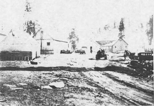
|
| AUBURN SKI CLUB C. C. C. CAMP |
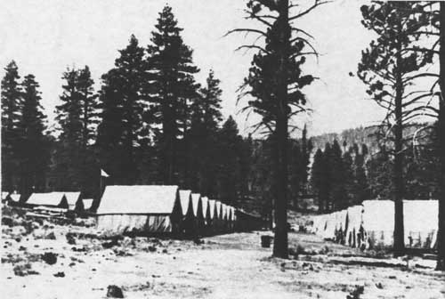
|
| SATTLEY C. C. C. CAMP. NOTE EARLY TENT STRUCTURES, 1933. |
The CCC conservation work had been so successful that, faced with permanent termination of the program in 1937, the Forest Service and other agencies began to draft legislation making the CCC camps part of a permanent policy of the U. S. government. Instead, the program was extended two years with slight modifications. In 1939, it was extended three more years. During these latter years of operations, CCC units on the Tahoe National Forest were terminated and most activities centered around camps at Grass Valley, Foresthill, and Hobart Mills (Directory of CCC Units, 9th Service Command, 1942). The final years were marked by substantial cutbacks in financing the program and unrest in the camps. When the war in Europe boosted the American economy and improved the employment picture, the need for the program rapidly diminished. The CCC program was terminated in July of 1943 (Salmond 1967: 179-199).
Gathering scientific data on rainfall, snow depth, streamflow, and lake levels has long been an integral aspect of California's attempts to more accurately manage its complex water storage and distribution systems. The earliest precipitation records on the Tahoe National Forest were gathered by individuals and corporations. Station agents for the transcontinental Central Pacific Railroad and the ditch-tenders for the mining and ditch companies customarily kept precipitation gauges at their places of work (Pagenhart 1969: 61). The eccentric water-cure physician and rustic health resort owner, Charles Bourne, kept measurements of rainfall and lake levels at Lake Tahoe during the 1870s (Bourne MS: np). By the end of the 1890s, the U. S. Geological Survey budget permitted establishment of stream measurement stations along major Western rivers. In 1900, engineers, for example, began monitoring Lake Tahoe's level and daily outflow into the Truckee River (Pisani 1975: 143). Interest in predicting annual stream run-off through scientific analysis began in the 1880s. Dr. Church, the pioneer in the science of snow surveying, established regular measuring stations within the Tahoe National Forest area before the turn-of-the-century. For many years, Forest rangers assisted in collecting this useful data (Nelson Interview 1982).
| <<< Previous | <<< Contents>>> | Next >>> |
|
region/5/tahoe/history/chap5.htm Last Updated: 06-Aug-2010 |