|
History of Tahoe National Forest: 1840-1940 A Cultural Resources Overview History |
|
CHAPTER IV
Era of Development and Diversification, 1859-1906
During the years between the discovery of silver and gold in the Washoe in 1859 and the establishment of Tahoe National Forest in 1906, the economic activities begun in 1849 changed in their scale and focus. New mining technologies, coupled with refinements of systems invented before 1859 and the influx of outside capital for financing changed gold mining from the nascent industrial form that had been established earlier, to a modern industrial system dependent on technical skills, scientific knowledge and processes, and a permanent, trained work force. In drift, hydraulic, and quartz mining such development altered the mining system forever.
The entry of outside (i.e. San Francisco, New York, or London) capital contributed to the development of other industries in the Forest. Initially investing only in mining, capitalists now poured their money into logging, transportation and water development. Each had reached a plateau by 1859, and thereafter was primarily advanced by the entry of new sources of money to aid further development. While large scale capital did not directly effect agriculture, the new markets for agricultural goods in the Washoe, and those opened by the Central Pacific Railroad, led to greater agricultural development within the Forest. Increased agricultural production required more intensive use of resources, and led to the system of irrigation and grazing on the public domain present today.
The period of development and diversification of industry and economic activity on the Forest also affected community development. As we have seen, the early transitory mining camps that sprang up in the early years of the gold rush were replaced by more permanent towns based on deep deposits or favorable locations. Industrial mining after 1859 continued this process. In addition, new communities developed independent of direct ties to mining. Settlements identified with railroad stations, logging and lumber industries, and agriculture expanded during these years. There was greater stability in population. The periodic "rushes" and mining excitements, with a few exceptions, ceased, and the great population fluctuations associated with the gold rush decade were tempered. As mining and other communities became more "family" oriented, a higher percentage of women and children were present than in the earlier settlements.
|
|
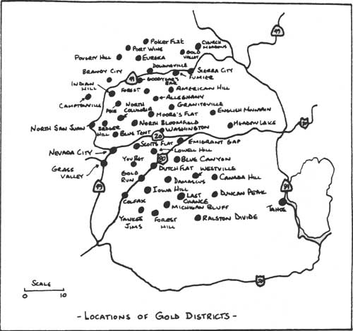
LOCATION OF GOLD DISTRICTS (click on image for a PDF version) |
The Mining Industry on the Forest.
Mining for gold and other minerals on Tahoe National Forest during 1859-1906 was largely carried on in the areas developed during the first decade of the gold rush period. For example, mines in Alleghany and Michigan Bluff, located in the early 1850s, remained active throughout this period. Some locations, uneconomical in the early years, became valuable producers after new technologies aided access to gold deposits (MacBoyle 1918: 5). Mining methods depended on the type of gold deposits mined — placer gravels or quartz lodes — and production was affected by technological advances such as the introduction of practical electrical power in mining and milling (State Minerologist 1894: 413). Knowledge gained in the deep Comstock Lode mines proved valuable as California miners tunneled to greater depths. "Once back in California, the former Comstockers quickly demonstrated the necessity for sinking shafts to greater depths than Californians had believed financially feasible, and when they proved their point on that score, they automatically forced Californians to give attention to methods of underground ventilating, to adopting better hoisting equipment, and to replacing hemp rope with steel or iron cables" (Paul 1947: 289-290). Shafts formerly 100 to 200 feet deep were dug and blasted to below 1,000 feet (IBID: 290). New methods allowed for continued development of mines like those at Sierra Buttes, discovered in 1850, well into the twentieth century (Sinnott 1976: 217). The new methods also prompted rushes to areas hitherto untouched, like the Meadow Lake and Squaw Valley areas, in the 1860s (Fatout 1969: 25; Gudde 1960: 74, 108, 188, 237, 345). The development of more sophisticated hydraulic mining methods also led to the development of gravel mines at North Bloomfield, and in the Washington vicinity during the 1860s (MacBoyle 1918: 99-105). Hydraulic mines were scattered on the forest wherever there were deposits that could be worked by this method and water was available (Clark 1970: passim). Drift mining, discovered and used before hydraulicking began, regained a prominent place in mining industry, especially after the end of widespread hydraulic mining in 1884 (Vivian 1890: 427).
A change in the organizational structure of gold mining was necessary in order that gold mines could develop industrially. As we have seen, miners banded together as technological improvements altered mining methods. The gradual result was the employment of hired miners on claims. This practice started largely with river bed mines, worked at first as cooperatives and later with miners as employees. Miners also cooperated to dig mining water ditches. This business later became, like mining, industrialized. Financing shifted from the miners to local businessmen and finally to capitalists from outside the mining region. This fact had its effect on mining communities. The Nevada City Gazette noted in May 1869 that
Grass Valley lives not off the mines, but the miners — an important distinction. The wealth of the mines all goes to San Francisco. The wages of the miners are spent here . . . (quoted in Lingenfelter 1974: 87)
The investment of large sums of outside capital required claims large enough to ensure a profitable return. As rules were gradually changed in the 1850s to allow larger claims such investments became more practical. By 1872, the United States Mining Law allowed placer claims of twenty acres per person, or 160 acres for a single association of at least eight (Pagenhart 1969: 109-110). Similar changes were made in quartz mining law assuring capitalists that their claims would enjoy legal protection sufficient to allow for safe investment (Paul 1947: 226-227; 237-238). For consolidation of claims and codification of mining law resulted in economies of scale and made potential investors more willing to risk their money (Pagenhart 1969: 110).
During the last four decades of the nineteenth century, most of the major mines on the Forest were operated by miners using investment capital from outside the gold region. The Malakoff Mine at North Bloomfield, for example, was organized in 1865 by Jules Poquillion, and by 1866 was established as the North Bloomfield Gravel Mining Company under the leadership of Lester L. Robinson and a group of San Francisco businessmen. Within eight years there were thirty shareholders with $3.5 million invested in the mine (California Department of Parks and Recreation 1979: 14). A similar situation prevailed at the Bald Mountain Drift Mine at Forest City. Located at first by a group of miners who tried and failed to mine it cooperatively, it eventually fell into the hands of M. Redding. By 1869, new stock was issued, tunnels were dug and the mine became quite profitable (Fariss and Smith 1882: 478-9). Mining shares were sold in San Francisco, Stockton and Sacramento in the early 1860s; very rapidly thereafter "Easterners and Europeans . . . began sending their capital to the Pacific Cost for investment" (Paul 1947: 183-4). In fact, the need for capital in California and Nevada was such that by the mid-1860s, a major change in California banking practice was necessary to make them able to meet the heavy demands put on them by mining. Money from British sources began to arrive and the banks became eventually of great significance as channels through which foreign funds were directed into Pacific Coast investments (Paul 1947: 184-186).
The mining and milling of gold bearing quartz required deep tunnels, heavy machinery a transportation network, stamp mills to crush the ore and a reduction plant to process the gold itself. Large numbers of miners were needed to work deep mines, and skilled engineers and chemists to design the mines, equipment, and process the ore (Wiltsee 1931: 4; Spence 1970: 79, 144). The Mining and Scientific Press (11/21/1903: 332) noted this change in 1903 in an article entitled "Advantages of Technical Education."
Within the past twenty years this old-time practical miner has been slowly forced into the background and in his place is found the technically educated man, who with a worldwide knowledge of his business is equal to almost any emergency . . . The western U. S., Australia and South Africa have furnished a practical school, where unusual conditions were found and had to be met — novel situations in mine and mill. The old-timer would have undertaken these varied problems in the old time manner and he would have failed, or at best would have made but a moderate success.
Similar technical skills were needed in the development of deep drift mines, as many of the same problems were met as in quartz mining. Hydraulic mines, while not always as technically complicated in an engineering sense, required vast capital outlays for construction of adequate water systems (Kelley 1959: 34-41 passim). Water companies developed parallel to hydraulic mining as some miners got out of mining and went into water instead (Pagenhart 1969: 85-88). The South Yuba Canal Company is an example of such a company.
After 1859 emphasis was placed on drift, hydraulic, and quartz mining. To be sure, other methods of mining still went on; as late as 1880 Chinese miners still mined river beds and reworked mine tailings (Public Lands Commission 1880: 17). Other groups or individuals were still prospecting or working small claims, but the bulk of production was in the large industrial placer and quartz lode mines.
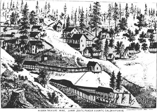
Drift mines represented one of the largest producers of gold, mostly because this form of mining, like quartz lode mining, survived longer than did hydraulicking. As mentioned earlier, drift miners initially followed the Tertiary Gravels into the hillside and mined the deposits in a manner similar to quartz mining. Gold bearing gravels were shoveled into hand cars, removed from the mine and washed in long sluice systems. When the gravel was compacted into cement, stamp mills were employed to crush it (Vivian 1890: 428). Drift mines, with their long tunnels, used large amounts of timber. At the Bald Mountain Mine at Forest City, "enormous quantities of heavy timber are required in the tunnels to support the vast masses of loose gravel above" (Fariss and Smith 1882: 479). Hand cars, mule cars and small locomotives pulled ore out of the mines. The Hidden Treasure Mine, near El Dorado Canyon in Placer County, replaced its mule cars with a locomotive from Philadelphia in 1882 (Thompson and West 1882: 220). The Paragon Mine, owned by Abraham Breece and Judson Wheeler, near Bath in Placer County, had a tunnel into the gravel deposit three quarters of a mile long; the Mountain Gate Mine at Damascus "struck the blue gravel after running a tunnel of seven thousand feet" under a volcanic cap. Hand and mule cars carried the ore from the mines. Some of these mines employed a few men; the Paragon, despite grossing $13,000 per month in the 1880s had a small crew (IBID: 219, 230-231). Most of the more productive mines had much larger operations. The Bald Mountain Mine supported a town of 800 (Public Lands Commission 1880: 17). The Bald Mountain Mine was described in 1882:
The main tunnel is now a mile and three-quarters into Bald Mountain, at one place being thirteen hundred feet below the surface. Side tunnels from one hundred and fifty to five hundred feet in length extend on either side, at an average of eighty feet apart, of which there about two hundred and fifty, the intervening gravel of the channel being excavated as they proceed. The limit of the claim will be reached at a distance of two miles from the mouth, and the coming summer will see its completion, when all the pay gravel will be cleaned up, and the pillars taken out. Tracks are laid in all the tunnels being worked, over which an engine, christened 'H. K. Wallis' in honor of the superintendent, makes hourly trips both day and night, carrying cars to and fro in the long interminable corridors. The main tunnel has a total raise of 207 feet from the mouth inward to the locomotive station, as it follows the course of the channel, creating a perfect system of drainage. Four hundred and forty-one acres of mining ground are owned by the company, four miles of creek, two flumes of a half a mile each, a mile and a quarter of washing flume, and at the bottom of the latter flume tailing claims 8,000 feet in length. Two dumping yards, double-planked, with a capacity of 25,000 cubic yards each, receive during the summer, when water is scarce, the gravel to be washed . . . At present the number of men on the payroll of the company is 140, the number having reached as high as 230. Nearly all the gold found in the great blue lead is very coarse, the largest piece ever taken from this mine weighing over seventy-five ounces. The yield of the mine for the last ten years has been about $2,000,000, of which $795,000 were paid in dividends. (Fariss and Smith 1882: 478-9)
Of course, drift mines were not usually as large or productive as the Bald Mountain. Other drift mines of such size included the Hidden Treasure (or "Sunny South") northeast of Michigan Bluff, employing seventy men in 1882, with a "school house, two hotels, and two stores, and numerous cozy and well-furnished family cottages" located nearby. The mine produced $114,168 in 1880 (Thompson and West 1882: 220, 388). By 1890, the mine had a crew of 135, whites and Chinese, as well as 1,000 feet of sluices and an 8,000 foot tunnel (Vivian 1890: 430). The Mountain Gate at Damascus was worked by about twenty miners but supported a community of 150 that boasted a school with "about twenty-five scholars," plus cottages with gardens, a store and a "large hotel." The mine yielded $1,000,000 between 1860 and 1882 (Thompson and West 1882: 378). Drift mines were also located around Downieville the Duncan Peak district in eastern Placer County near the Greek Store Station, at Damascus, and in Nevada County in the Relief Hill, Grizzly Hill, Graniteville and Lowell Hill districts (Clark 1970: 44, 43; MacBoyle 1918: 92, 94-96, 99, 11, 30-31). Valuable drift mines were also found on an ancient channel running from Minnesota, Chipps Flat and Alleghany through Monte Cristo and on into Plumas County, as well as in the Slate Creek region in Sierra County and above the Bear River at Liberty Hill (State Minerologist 1882: appendix 174). The North Bloomfield and Derbec drift gravel mines in 1888 employed twenty-five and one hundred men, respectively, and were among the largest in Nevada County (State Minerologist 1888: 454-458). Other drift mines were located near hydraulic mines and references often combine them under the heading of "placer" mines, making it difficult to know which mines used the drift method (Clark 1970: passim).
|
| HIDDEN TREASURE MINE, SUNNY SOUTH PLACER COUNTY, CAL. (M H POWER) (Thompson & West 1882: 224) |
Drifting, in 1890,
. . . is of most importance now in Placer, Nevada and Sierra Counties. It is a revival, having been pursued to a considerable extent early in the history of the State, and then abandoned for the hydraulic style . . . (it is now the) most safe and certain branch of the business extant. (Vivian 1890: 427)
The report noted that while some mines employed 100 to 200 men, most were worked by ten to fifty. The Forest Hill Divide region was noted as being especially rich in drift mines.
The major drift mines were operated by mining companies for the benefit of stockholders (Fariss and Smith 1882: 478-9). The shares of stock were sold as far away as England; in 1882, the State Minerologist noted the failure of an English-owned drift mine at Whisky Diggings in Sierra County. Ironically the mine produced well after the disappointed English investors pulled out (State Minerologist 1882: appendix 180). Money invested paid for wages (in 1888, $2.50 to $3.00 a day in most mines) as well as equipment, including water wheels for compressed air, hoists, cars, drills, stamps, pumps, boilers, sluices and mills (State Minerologist 1888: 454-475 passim).
Quartz mining was also a productive form of mining undertaken on the Forest; however, it was also the most technically difficult in terms of mining and milling the gold ores. Quartz mines operated by digging into a quartz vein, aided by drills and blasting powder, and shoring up the tunnels and shafts as mining proceeded. Ore was removed by hand or mule cars, and processed in stamp mills where the gold would be freed from the surrounding native rock. California miners made improvements on early mill designs and produced the California Stamp in 1851. Such mills replaced the animal-powered arrastres and Chili mills that had been used earlier. Improvements in mills over the years gradually made the more dependable and effective at crushing ore, and methods for automatically feeding ore into the stamp mill were developed. While early machines were wasteful (as much as sixty to eighty percent of the gold was lost in the early years), improvements in refining led to a greater percentage being saved. The chlorination process introduced in 1858 and largely perfected in 1860 solved the problem of separating gold from sulphide ore, something mercury had been unable to do (Paul 1947: 135-142). The combination of better milling and refining methods and the exhaustion of placer gold in many areas had made quartz lode mining attractive in the late 1850s, especially as there were "untouched quartz veins" in the foothills. Miners knew that "the history of other parts of the world had shown that a good vein would last for a greater number of years than any other type of deposit" (IBID: 143).
Quartz deposits were found as high as the Sierra Buttes and as low as Auburn. Within the Forest quartz mines were located largely on the western side of the Sierra Nevada, with the exception of small mining activity around Sierra and Squaw valleys (Sinnott 1976: 129; Gudde 1960: 237, 345). Quartz lodes were discovered in Humbug Canyon in Placer County by James Lynn and others in 1853; however, as noted, mining in the quartz deposits throughout the Forest reached its peak after 1859 (Thompson and West 1882: 217-218).
The mine manager was expected to be familiar with all phases of the mine operations.
Basically, his task was to take charge of a property, direct exploration and development, and make provision for the extracting, processing, and even sale of its ore. In finding and extracting ore, he had to have some knowledge of geology, minerology and surveying. Extracting required knowledge of tunneling, drifting, and shafting. He had to be skilled in mechanical engineering to plan for installation and use of hoisting, ventilating, or draining equipment, and an underground transportation system. Chemical and metallurgical skills were necessary to supervise ore treatment . . . (he) must understand milling, reducing or smelting machinery. A manager also frequently had to assume the role of civil engineer to build roads, tramways or flumes. He was a business manager . . . and supervisor of a large work force and responsible to his employer or corporation board. (Spence 1970: 144)
Large mines had a compliment of subordinates, including mill and mine superintendents. Deep complicated mines often had assistant superintendents at each level, as well as shift bosses, mechanics, and others. A shift-manager's success was determined by the efficiency of production. Labor costs often represented sixty to seventy percent of underground expenses. By the 1870s U. S. universities were beginning to graduate mining engineers, who over time became influential within the mining industry. Many became managers of mines, technical consultants to owners, investors and promoters, or expert witnesses in litigation (IBID: 79, 144, 168).
|
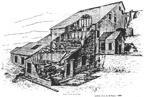
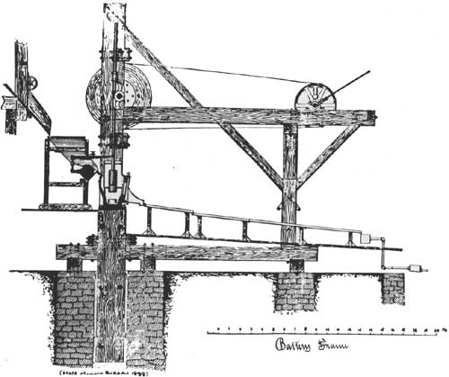
| FORTY-STAMP GOLD MILL (State Mining Bureau 1888) |
|
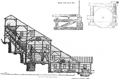
| CROSS-SECTION FORTY-STAMP GOLD MILL (State Mining Bureau 1888) |
|
| (State Mining Bureau 1888) |
Deep mines also required a skilled work force. California's quartz mines were manned by miners who had become experienced in mining elsewhere. Some had worked in the Nevada mines; others came from areas in the U. S. or Europe where mining had been practiced for many years. Among the most famous group of deep miners were the Cornish. Some had arrived early in the gold rush, but "their regular introduction into mining proper was a subsequent phase: they came in continuously after the original impulse of the gold-rush had ended in the mid-fifties, and thousands — miners and non-miners — had left with their takings, or without. Those who came in were professional miners . . ." (Rowse 1969: 257). Some mined briefly before opening other businesses or ranching; others stayed in mining. "Samuel Blight (who came to Grass Valley at eighteen) after many years of both quartz and hydraulic mining became captain of various mines in the district" (IBID: 262). John Tamblyn combined a variety of careers. He arrived in California in 1864, became foreman of a mine in the Owens Valley, and then traveled to Sierra City where be built a chlorination plant. He raised fruit on a small ranch, and in 1875 became a Methodist minister whose circuit included "the mountainous counties of the state" (IBID: 259). The Cornish became especially important in the mines around Grass Valley and Nevada City, where by 1861 most of the mining was done by the Cornish (Paul 1947: 323). Cornish miners later formed the first miners' unions in the area in 1869, largely over the issue of the use of one-man drills and dynamite, which the miners said were unsafe (Rowe 1974: 120-124).
By the 1860s most of the necessary preconditions for the development of deep quartz mines had fallen into place. Refining processes allowed more efficient recovery of gold ore, experienced miners and managers were available, and capitalists began to invest in the mines as confidence in them recovered from the damage done in the 1850s (Paul 1947: 300-302). This renewed interest stimulated the quartz mining industry and expanded production but it did not insure success. Some areas developed deep, long-lasting productive mines that operated well into the 1900s; others were prospected, mined, and gradually abandoned; still others were prospected, mined, and produced spectacular failure.
One of the most famous of California's deep quartz mines was the Sierra Buttes Mine near Sierra City. The ledge was located by Italian miners in 1850, and was worked through the rest of the century. The Reis Brothers soon bought out the original owners. In 1864, they built a seven mile ditch around the Buttes to the mine at a cost of $20,000. The Reis family sold the mine in 1870 for $1,000,000 to a London-based group who called themselves the "Sierra Buttes Gold Mining Company" (Fariss and Smith 1882: 481). A developer of many other Sierra mines, the company had substantial capital investments and experience in California mining. It operated the Sierra Buttes mines for the rest of the century and made significant improvements in its operations (Jackson 1968: 141). In 1870, the mine had five tunnels. By 1882, four more were dug, as the original five were played out. In 1882, the mine's three mills had ninety-six stamps in operation. A snowslide in March, 1882, destroyed a thirty-stamp mill worth $40,000, with its water-powered turbine wheel power plant. The accident caused twenty men to lose their jobs and the monthly tonnage of ore crushed dropped from 5,600 to 300 tons. Nevertheless, the company was able to overcome this adversity (Farris and Smith 1882: 481). In 1888, the State Minerologist noted that the company had built nine miles of road to the mine to transport "ores, timbers, fuel, etc." Besides the stamp mills, "there are several arrastres in operation here . . . working on a lot of old tailings and not of recent production" (State Minerologist 1888: 573-74). The entire establishment was illuminated with incandescent electric lights powered by water turbine wheels. The mine employed 209 men at an average wage of $50.00 per month with board (IBID: 576-7). The company provided boardinghouses or cottages to house the workers near the mine (Farris and Smith 1882: 481).
|
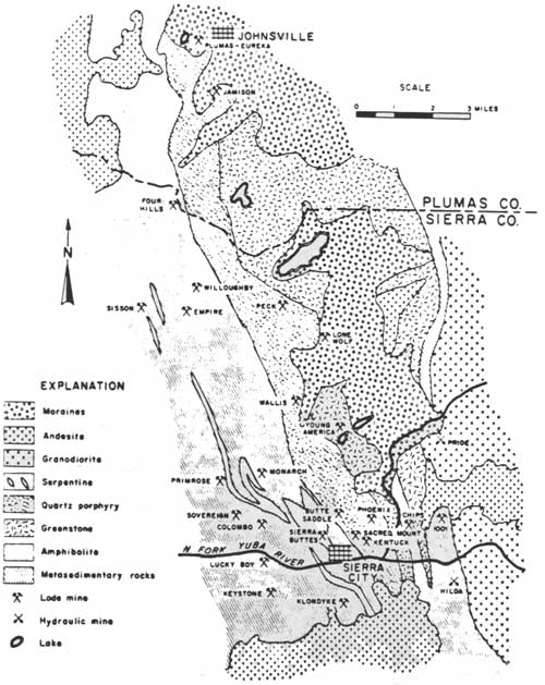
| GEOLOGIC MAP OF SIERRA CITY AND JOHNSVILLE DISTRICTS, SIERRA AND PLUMAS COUNTIES. After Turner, Downieville folio, 1897. (Clark 1970: 116) |
Other large quartz mines in Sierra County were noted in the Minerologist's report in 1888, including the Young America near Sierra City; the Rainbow and Eagle mines at Chipps Flat; the Myrtle and Gold Bluff mines near Downieville; the Buffalo in the Hog Canyon District; and the Rising Sun Mine in the Alleghany District (State Minerologist 1888: 478-580).
The Sixteen-to-One Mine at Alleghany in Sierra County was another of the important quartz mines of the period, and produced from 1896 through 1965, which made it the last major gold mine to close in the state. It produced an estimated $35 million during this time. In fact, the Sixteen-to-One was a consolidation of a large number of smaller mines and claims, including the Ophir, Rainbow, Rainbow Extension, Red Star, South Fork, Tightner, and Twenty-One. The Sixteen-to-One was named in "honor of the silver-gold ratio of U. S. coinage, as proposed by William Jennings Bryan in his campaign speeches" (Clark and Fuller 1981: 54-55). The activity around the Sixteen-to-One increased after 1890, and especially after the main claim was located in 1896. The mine was expanded through the rest of the century, and by 1907 the mine, and its consolidations, was known for the richness of its ore. Henderson L. Johnson, a former teacher and miner in Colorado and New Mexico, was the driving force behind the mine (IBID: 55). Much of the mine's later development came after the establishment of Tahoe National Forest.
There were a large number of important quartz mines within Nevada County, many of which were clustered around Grass Valley and Nevada City. Within the Forest, quartz mines were located in the Washington, Canyon Creek, Meadow Lake and Eureka districts. Mines in the Washington District included the Yuba, three miles above Washington; the Blue Bell, near Ormonde at the mouth of Canyon Creek; the Grafton and Eagle Bird, near the Blue Bell; the Washington Mine at Ormonde; the Champion at Maybert on the South Fork of the Yuba; and the Spanish Mine three miles north of the town of Washington (State Minerologist 1888: 435-442). The Spanish Mine was located in 1883 and the company formed in 1884 after consolidation of ten mining claims. By 1888, the mine had a tunnel 1,200 feet long, as well as other smaller tunnels. "The mine employs, besides a foreman, two white men and eight Chinamen, who extract about four thousand tons of ore per month, enough to keep the mill steadily occupied." Cars were hauled into the mountain by mules and traveled out by force of gravity. The mill employed six men; as was customary, the Chinese wages were about one-half that of the white miners (IBID: 442-444).
In the Eureka District, the major mine was the Gaston Ridge Mine, four miles south of Graniteville. The mine employed thirty miners and six mill hands. The mill was powered by a steam engine, its wood fuel delivered to the mine "by floating in the North Bloomfield Ditch." Workers were paid $3.00 per day (IBID: 448-450). Other mines in the district included the Rocky Glen, one and one half miles south of Graniteville, and the Gambrinus and Baltic Mines near Eureka.
The Canyon Creek District, running between the mouth of Canyon Creek and Bowman Dam, had three mines, the Chase Claim, Blue Jay and Canyon Creek (IBID: 452-3).
Deep mines were also located in Placer County, although most were centered west of the boundaries of the forest, in the area around Auburn and Colfax. The Sterrett Mine on Sailor Canyon was "on an immense lode of gold bearing quartz" (Thompson and West 1882: 218). The mines within the Forest boundary in Placer County were mostly drift or hydraulic mines. In 1890, Nevada, Amador and Sierra counties were the top quartz mining counties in the state. Placer County was far down on the list.
|
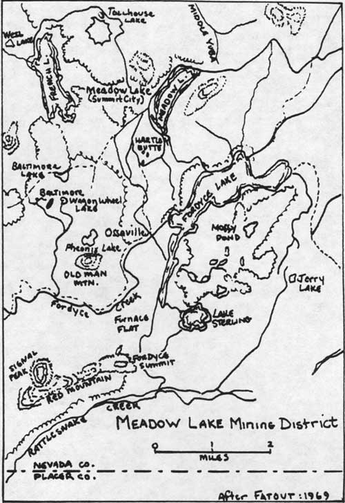
| MEADOW LAKE MINING DISTRICT (after Fatout: 1969) |
Of all of the Forest's mining districts, Meadow Lake has had perhaps the most varied history, demonstrating clearly the boom-bust cycle so familiar in mining. In the spring of 1864, news of a gold discovery at Meadow Lake caused a rush to the area. Gold was found as "thin flakes of free gold in the spongy decomposed rock on the surface" and in ledges two to eight feet thick. Unfortunately, the area was rugged and exposed. It was located on the crest of the Sierra Nevada at an elevation of 7,000 feet and was forty miles distant from Nevada City in a relatively inaccessible area between the Henness Pass and Dutch Flat routes to the Washoe Valley (Fatout 1969: 25-28).
Henry H. Hartley, a former bookstore clerk turned hunter, trapper and prospector was the person who had discovered gold at Meadow Lake in 1863. Hartley, with two others, formed the Excelsior Company and staked off claims the following year. The California Company also made claims, calling them the California Knickerbocker, Indian Boy and Indian Queen. By June, 1865, machinery for four quartz mills was on the way to the lake. Within a month there were 250 men and twenty women in the camp. Businesses quickly sprang up to serve the settlement, including sawmills, an assay office, a pony express carrying mail and newspapers three times a week to Nevada City, several butcher shops, a hotel and two saloons. In late June, the town site of Summit City was laid out on the southwest side of the lake, with wide streets set at right angles and named A, B, C, and First, Second, Third, and so on, with blocks of uniform size. Shortly thereafter three other "towns" were laid out — Richport, Lakeville and Baltimore City. By mid-August newcomers were arriving at the rate of one hundred per day. A "corps of hurdy-gurdy girls" migrated from Downieville, and a daily stage line from Gold Hill was established. By late August, there were stores, restaurants, boarding houses, saloons, three hotels, a brewery, bookstore, cigar shop and real estate office (IBID: 31, 35-40). The Marysville Appeal noted on August 20, 1865, that "seventy-five houses have been erected, a hurdy-gurdy establishment is in full blast, and a number of gambling houses have opened, and other indications of civilization are becoming apparent."
The onset of winter weather reversed the flow of population, but with the next spring a boom larger than the first began. Eventually eight "towns" existed in the area. Optimistic Meadow Lake citizens opened a stock exchange, and a newspaper (the Morning Sun) began printing in June, 1866. Despite the activity, only 300 miners were at work, and a lot of "dead-work" — road building, setting up mills, and so on — was yet to be completed. The newspaper noted that to get the rich ledges would require the aid of capitalists. "Individual efforts may prospect, but companies, regularly organized must develop mines," cautioned the editor of the Morning Sun. Such development capital was not available, especially as miners began to return from the area describing it a "humbug" and "the biggest bilk in the world . . ." (Fatout 1969: 68-77, 84).
Early in 1869 only seven families "rattled around" the 300 or so empty houses. By June the population was only forty or fifty people. Between 1869 and 1893 sporadic mining and attempts to deal with the high sulphur content of the ore came to little. In 1893 the winter passed with no one in the city; Hartley died in 1892 of opium poisoning. By the 1940s no buildings were left at the site, only faint outlines of streets and the Plaza (IBID: 109, 140-46).
Meadow Lake as a mining district was a failure, and thus compares unfavorably with successful mining districts like Alleghany or Sierra Buttes. The district does however reflect the boom-and-bust pattern of mining in the West. The miners dreamed of great strikes, help from outside capitalists, or new processes to help them through the lean years; in the end there was only disappointment. The town was virtually a prisoner of winter weather, which forced many to leave. Mining continued in the face of low grade deposits, bad weather and isolation, but the lack of sufficiently valuable ores eventually caused the town to die like so many other mining camps and towns in the West built on hope or on less valuable deposits.
Hydraulic mining is the remaining significant gold mining technique used on Tahoe National Forest during the latter nineteenth century. More than any other kind of mining, hydraulicking has left permanent and massive scars on the landscape that remain visible today. All mining methods were to a greater or lesser extent environmentally destructive; hydraulicking was the most devastating of all. The process "eroded hills, wrecked roads, inundated buildings, clogged streams with debris, flooded grazing and agricultural land, and obliterated whole towns" (Fatout 1969: 23). Hydraulicking has left pits, debris fills, abandoned flumes and canals, tunnels, and dams on the Forest.
Hydraulic mining was developed early in the gold mining period. Between 1853 and 1868 the process underwent a period of experimentation during which many of the production problems were ironed out. Major innovations discussed earlier included the change from canvas hose to iron pipe to tolerate higher water pressures starting in 1853; improvements in stilling and measuring devices; more powerful nozzles, usually called "giants" or "monitors" able to direct the jets of water under extreme pressure; the use of explosives to break up cemented gravels; and improved sluicing systems (Pagenhart 1969: 101-104). By the later 1850s, hydraulicking was in wide use, wherever conditions allowed it. In 1858, a writer for the Alta California traveling through the northern mining districts witnessed hydraulic mining and tunneling operations that were "conducted on a gigantic scale." In western Sierra County, he observed "multifarious bank claims supplied with water from ditches and flumes which cross then recross the county in every direction . . . in fact the hills and flats are grid-ironed with long lines of boxes, conveying the indespensible element to the dry diggings" (White 1961: 84). Flumes and canal systems designed to provide water for long toms and sluices were unable to meet increased demand for water once hydraulicking began. It was a popular mining method, "so effective that from that day forward no other form of placer mining was attempted if hydraulicking were at all possible" (Pagenhart 1969: 101). Invented in California, hydraulic technologies rapidly expanded to other areas in the West. Charles Yale, in California Mines and Minerals in 1899, stated that "it may be considered exclusively the product of California" (quoted in Pagenhart 1969: 101).
The years 1859 through 1864 were depression years in the hydraulic mines of the Yuba-Bear basins because of "desertions" to the Fraser River and Comstock mining areas. In Nevada County only North Bloomfield and Omega mines were active because they were adequately supplied with water — North Bloomfield with water from the Irwin Ditch of the Eureka Lake Company, and Omega from a branch of the South Yuba Canal Company ditch (IBID: 116). Draught also severely hindered all hydraulic operations between 1862 and 1864. However, after 1864, hydraulic miners found that both water and finance capital was available for expansion as the draught ended and the Comstock excitement generated renewed interest in mining investments (Kelley 1959: 33-34).
As hydraulic mining gained in popularity its debris and tailings began clogging up small creeks. Only those mines operating near major river channels could economically remove the mountains of debris. Thus, many small operators and those with unfavorable locations were forced out of business. Between 1867 and 1870 these problems were basically worked out, as new drills and dynamite eased construction of drainage tunnels to remove debris (IBID: 41-42). By 1870, W. A. Skidmore, a mining expert, could assert that "hydraulic mining has made such rapid strides on the road of progress, and assumed such monster proportions in the past year or two, that now the vast magnitude of its operations serves to almost totally eclipse every other branch of mining industry (IBID: 45).

|
|
NORTH BLOOMFIELD AREA ca. 1875 (after Pagenhart, 1969) (click on image for a PDF version) |
Hydraulicking required tremendous amounts of water. Water was sold by the "miner's inch," which varied in many areas at first, but became relatively standardized at about seventeen thousand gallons in twenty-four hours. The North Bloomfield Company's ditch system had a capacity of 3,200 miners inches, or 5,440,000 gallons per day (State Minerologist 1888: appendix 152, 161). In 1879, the North Bloomfield mine used over fifteen billion gallons of water (State Minerologist 1882: appendix 172). Other necessary resources included lumber for flumes, dams, and general construction; pipe and monitors; stamp mills to break up cemented gravels; sufficient sluicing to recover the gold; a system to remove the debris; a sufficient work force to operate the mine; and enough financial strength to get the mine started and operating smoothly before pay dirt was reached, as well as enough to enable the company to develop the necessary water transportation system. Interestingly, hydraulic mines and mining water companies were among the first to use electric lights and telephones as a part of their operations. "In 1878 the North Bloomfield, the Milton, and the Eureka Ditch Company built the first long distance telephone line in the United States, stretching from French Corral up the San Juan Ridge to the various ditches and dams of the three companies in the high Sierra." The system cost $6,000 to build and had its main office in North San Juan. The line connected twenty-two stations, and was used to monitor flows and watch for breaks. It replaced an earlier telegraph system. By 1880, the company introduced large electrical lights enabling the miners to see as mining went on twenty-four hours a day if water was available. The electrical system used power generated by water wheels and was one of the first industrial uses of electric lights in the nation (Jackson 1967: 50-51).
Hydraulic mining was, in essence, a grand form of sluice mining. Water under great pressure washed overburden and pay dirt through debris removal systems and complicated sluicing arrangements. Every so often the sluice was cleaned out; usually after running for several weeks or months. The system varied in size or scope rather than in technique.
All of the counties within Tahoe National Forest have hydraulic mining sites within their boundaries. These were on the west side of the Sierra Nevada, usually on the western (or lower) edge of the Forest.
Perhaps the most famous of all these mines was the Malakoff Mine of the North Bloomfield Gravel Mining Company. The area had been prospected in 1851 or 1852, when "a prospecting party consisting of two Irishmen and a Dutchman" found a rich placer deposit. After news leaked, a small rush to the location ensued; disappointment led many to call it a "humbug," thus naming the creek and camp in the area. Mining continued and in 1853-54 a number of miners began employing the hydraulic method. A small dam was put across Humbug Creek, and ground sluicing was done from 1855 through 1863. Miners made money, but were unable to get at the deep gravels in the area (IBID: 1-2).
After a period of relative quiet around the area from 1861 through 1865, mining at North Bloomfield picked up. There were fourteen hydraulic mines, one employing thirteen men; but the lack of proper drainage made working the claims difficult. As hydraulicking began to produce more gold, interested capitalists began investing in the development of the big mines around North Bloomfield (IBID: 4-5). In 1865, Jules Poquillion purchased several claims in the area. A year later he organized the North Bloomfield Gravel Mining Company with Lester L. Robinson and other San Francisco capitalists (California Department of Parks and Recreation 1979: 14). The company eventually owned 1,585 acres, with an estimated $69,600,000 in gold in the gravels therein.
Lester L. Robinson was typical of the entrepeneurs who assumed the direction of the hydraulic mining industry. He came to California in 1854, at the age of thirty, after a successful career as a railroad engineer in the East. He was responsible for building the Sacramento Valley Railroad . . . the first railroad on the Pacific Coast . . . (he became) an active partner in the Pioche firm (Pioche, Bayerque and Co.) and he turned his talents to a wider field of investment. (IBID: 6)
Robinson was also a director of the Giant Powder Company and several mines in California and Mexico; he was involved in irrigated agriculture near Riverside, and invested in tin, insurance companies and oil wells (IBID: 6).
Realizing that they would need more water and better drainage to work the mine, several projects were considered. A proposed canal from the Little Truckee River was never built; but the company did purchase Rudyard (English) Dam at the head of the Middle Yuba River in 1868. This dam was the largest in the state at that time. The company also began to look for another site, and in July 1868, they engineered and began construction on a canal from North Bloomfield to Poorman Creek using a force of "800 Chinamen and 300 hundred white men." From August 7 to December 21, 1868, they built twenty-seven miles of ditch. The next year seventeen miles more were built to connect the canal to Big Canyon Creek; the canal system became known as the best in the state. When completed the ditch was fifty-five miles long, three and a half feet deep, 8.65 feet wide across the top and five feet wide at the bottom. "The ditch and distributors cost $422,106.14" (IBID: 10-11).
To fill the ditch the company built a reservoir and dam at Bowman's Ranch on Big Canyon Creek in 1868-1870. The dam was sixty-five feet high and 215 feet long, and built of timber ballasted with rock. A small diversion bay below the main dam put water into the canal. The dam burned in October 1871; it was temporarily repaired, rebuilt in 1872, and raised in 1876 to a height of 100 feet (IBID: 12-15).
In order to drain the mine the company built a bedrock tunnel 7,800 feet from Humbug Creek to a point 200 feet below bedrock level, allowing the gold gravels to be drained. The tunnel cost $275,574 (California Department of Parks and Recreation 1979: 15).
By 1876, the company was ready to begin full-scale activity. In July, 1876, the mine ran seven four- to eight-inch monitors twenty-four hours a day. As was the case in most hydraulic mining towns, North Bloomfield had a large number of Chinese; almost half of the miners in town in 1878 were Asian. Besides mining, the Chinese in North Bloomfield grew fresh vegetables for market. By 1880, the population of the town reached 1,229. With the end of hydraulic mining (1884-1893) the population dropped rapidly; in 1900 there were only 730 left (IBID: 16-19).
There were many other hydraulic mines in the Forest, most of which were smaller than the operations of the North Bloomfield company. Hydraulicking went on in Placer County at Dutch Flat, Emigrant Gap, and Michigan Bluff; in Nevada County in the Washington District at Alpha and Omega, and at Relief in the North Bloomfield District (Clark 1970: 45, 46; MacBoyle 1918: 45, 99). Sierra County was also the scene of extensive hydraulic mining at Morristown, Monte Cristo, Craigs Flat, Excelsior (near Monte Cristo), Eureka District, and near Downieville (Mountain Messenger 9/18/1880; Sinnott 1972: 190, 171, 195; Clark 1970: 46; Fariss and Smith 1882: 480).
One of the most extensively hydraulicked areas of Sierra County was around Brandy City. As early as 1854, the Sierra Citizen (3/4/1854) noted 150 miners at work with sluices in the dry diggings. The dry winters of the early sixties and a general "petering out in the diggings" caused hardships for many miners, a number of whom left the Brandy City area in 1864 (Mountain Messenger 8/6/1864). New finds led to renewed mining in 1867, when the Mountain Messenger described some of the mines near the city.
Everyone is piping away in a lively manner, making the best use of the water while it lasts. Van Ransalair and Co., Morgan, and Arnott and Co. are all piping away in a lively manner and the prospects are flattering for good returns. (Mountain Messenger 5/25/1867)
The main portion of the town's water supply came from a flume that connected the town and the mines to Canyon Creek, ten miles away. Known in the 1860s as the Hoosier Ditch system, it later became the Brandy City Ditch. The flume rounded a rock outcropping above Canyon Creek where iron bars supported it. The bars were still visible in the 1970s (Sinnott 1977: 150). Hydraulic mining in the vicinity of Brandy City flourished into the 1880s. The Brandy City Mining Company in 1883 began construction on a 3,400 foot long sluice tunnel scheduled for completion in 1885. The company brought in tunnel digging machinery on the first teams and wagons ever to arrive at the town from the outside world. With the new machinery in place and the tunnel near completion, the future looked bright for the mining company (Sierra Citizen 7/19/1883; 9/6/1883). Unfortunately the mines were effectively shut down by the Sawyer Decision in 1884. Several years later, the Mountain Messenger discussed its impact on Brandy City:
Times are very dull at Brandy City, but we are living in hopes that the mine will be allowed to run, which will change matters greatly. The Company will continue working the mine if the debris case, which is now before the U. S. Circuit Court, is decided in their favor. (Mountain Messenger 7/23/1892)
Despite the fact that the appeal was unsuccessful, mining continued in limited fashion at Brandy City throughout the century. In November 1907, the Brandy City Mining Company was planning to resume hydraulic mining operations. Renewal of hydraulicking enabled Brandy City to hang on as a mining settlement for several years. In 1911, the county newspaper stated that the town was "going along nicely" (Mountain Messenger 11/16/1907; 4/22/1911)
One of the most important aspects of hydraulic mining everywhere was the water delivery systems that developed around it. The canals, ditches, flumes, dams and reservoirs represent a complicated part of the hydraulic mining industry, and are among the most prominent existing historical resources on the Forest. Additionally, these water developments have served more than just mining, and have become important in irrigation and hydroelectric power generation for mines and towns. Some mining companies like the North Bloomfield Gravel Mining Company owned their own systems; more often miners bought water from water companies. These organizations, and the men who built them, often gained more gold than did the miners. Like the mining companies, they were capital-intensive, and often headquartered in San Francisco or New York (Pagenhart 1969: 6; Paul 1947: 297).
One writer has described the three "single purpose systems" that developed in the Yuba and Bear River basins; much of what went on there applied to the American River Basin as well. The three systems were hydraulicking, hydroelectric power generation, and irrigation. Hydraulic mining use of water has been discussed above.
The second of these systems, hydroelectric power generation, grew directly out of the accumulated technical knowledge and water supplies that were concentrated in the former mining area. The third system, irrigation, needed support from the beginning, and survived in the Yuba-Bear area primarily because of the change in public attitude that took place at the end of the nineteenth century. (Pagenhart 1969: iii)
Initial construction of water systems began in the 1850s. In Nevada County in the spring of 1852 the Little York Ditch was dug, tapping the Bear River near its headwaters and sending water eighteen miles west to You Bet. In 1858, another ditch was built into the area, and between 1852 and 1855 the Walloupa Ditch was dug fifteen miles up Steephollow Creek (IBID: 94). This early development of ditches also went on in Placer and Sierra counties. In 1855, the El Dorado Water Company had thirty miles of canal and laterals near Michigan Bluff; the Sacramento Daily Union (12/14/1854) reported on the ditches of Sierra County in December of 1854. These included Havens and Craycroft Wisconsin Ditch, Minnesota Ditch, Halfway Water Ditch, Chipps Digging Ditch, Walton and Company's Ditch, and the beginning of the Sierra Nevada Lake Water and Mining Company's ill-fated ditch from the Sierra Nevada crest to Minnesota (Thompson and West 1882: 151).
The mines and water companies of San Juan Ridge also grew between 1850 and 1853, and their story is instructive as an example of water development for mining. By 1851, the surface placers of the ridge were "known and claimed," and ditches began to serve the long toms and sluices that mined them. A ditch was run twelve miles from Shady Creek to French Corral in the winter of 1851-1852. By 1853 ditches were noted running from Poorman Creek to Eureka (later Graniteville). Miners and prospectors explored down the ridge from there, having come up the South Fork of the Yuba River to Poorman Creek and up the creek to Eureka. The experienced ditch builders also began the Grizzly Ditch to Cherokee in 1854, which tapped Grizzly Creek and Bloody Run. A branch of this ditch ran from Cherokee toward North San Juan in 1853-1854. The last of the pre-hydraulic mining ditches dug in the area were the Poorman Creek Ditch from Poorman Creek to Eureka and Moores Flat, and the Irwin Ditch from Poorman Creek to Relief Hill and Humbug Creek. The Irwin Ditch had been under construction since 1851 (Pagenhart 1969: 96-99).
|
|
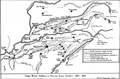
YUBA BASIN HYDRAULIC MINING DITCH SYSTEM, 1854-1884 (after
Pagenhart 1969) (click on image for a PDF version) |
After hydraulic mining began the demand for mining water grew faster than these early ditches could manage. Mining companies began to look for more certain supplies.
In the early mining days, operations were often completely suspended during unseasonal droughts. The economics of later corporate enterprise, however, made intolerable such unreliable water supplies, and the main reason for the early construction of headwater storage dams. Storage facilities had to be planned for a possible extension of the regular summer drought well into winter. (IBID: 75)
The water systems developed during the hydraulic period (1854-1884), whether owned by mining or water companies, had similar systems of dams and ditches. Water systems usually had three types of dams: diversion, storage, and distribution. Diversion dams were built across a waterway to direct the flow of the creek or river into the mining ditch. These rapidly developed into larger storage dams simply by enlarging the diversion wall. Storage dams were also built to increase the capacity of Sierra Nevada lakes. As early as 1850 rock and flashboard barriers were built across the outlets of White Rock and Upper Peak lakes. This became a popular means of dam building; in 1855 several others were built, and between 1855 and 1865 twelve such enlargements were made. Between 1865 and 1885 nearly twenty-four more were added (IBID: 112-113). Other storage dams were built in narrow canyons or at strategic locations in headwater valleys. Rudyard Dam was built in 1858 of dry laid stone faced with boards. Bowman Dam was built in 1869 for the first time in the same fashion (Jackson 1967: 10-13). Masonry dams were not built in the Yuba-Bear basins until the 1890s when they were needed "for other and more permanent uses." Wood-faced dams were often poorly built and suffered from rotting wood. By far the greatest number of dams were the small distribution/diversion dams at branch locations or at the end of the canals. These were small, shallow often temporary structures used to store several hours supply of water and to regulate flows toward various customers (Pagenhart 1969: 113).
The ditches and flumes that carried water in these systems varied in size and method of construction. One flume in Sierra County was twelve by eighteen inches; by contrast the North Bloomfield Ditch was three and a half feet deep, 8.65 feet across the top and five feet across at the bottom (Sacramento Daily Union 12/14/1854; Jackson 1967b: 10-11). In general, flumes were less expensive than canals in rough terrain. The successful ditches of the mid-1850s were those that had been built early on with sufficient capacity to sell water to the hydraulic mines. Because of the large demands put on the ditches, only those that had been built as big as possible were usable and thus the companies that built them survived (Pagenhart 1969: 114). Ditch tenders, who had cabins or stations along the ditch route, monitored and maintained the canals (Jackson 1967 b: 50-51, 13). Examples of these ditch tenders' cabins still exist within the Forest (Tahoe National Forest Archaeological Site Forms).
Ditches and canals varied not only in size, but in length. Many were small, local ditches used by the smaller placer mines; however, some ditch systems attained massive proportions. The South Yuba Canal Company's system included 275 miles of ditch on the ridge between the Bear and South Fork of the Yuba River; the Eureka Lake and Yuba Canal Company, which had begun operations in 1858, absorbed smaller companies so that by 1875 it controlled 300 miles of ditch, with a main canal running from Lake Faucherie to North San Juan, a distance of some sixty-five miles (Kelley 1959: 4). By 1879, there were 900 miles of ditches in Nevada County, 1,000 miles of smaller ditches were added. The total cost of the ditch system was estimated at $7,000,000. Thus, these large companies rivaled the large corporate mines in size and level of investment.
Some of the flume systems included sections that were considered "engineering marvels." The Eureka Lake Company built two high flumes: the "National Flume," which spanned 1,800 feet and was sixty-five feet high; and the "Magenta Flume" across Cherry Hill Gap, 1,400 feet long and 126 feet high (Pagenhart 1969: 128).
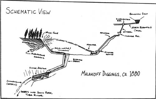
Once water reached the hydraulic mine through the distribution system, it was applied to the mine face. Water ran down iron pipe penstocks to build pressure, through a "stilling" device to reduce turbulence and catch stones, and then out through the monitors, hitting the mine face with tremendous force. A reporter for the San Francisco Bulletin wrote about his visit to the Malakoff Mine in 1879, and described the use of the hydraulic monitor.
. . . The water has done its work here, and washed out all the loose earth and smaller rocks. Now the next thing is to get rid of the large boulders, often weighing tons. They must be blasted into fragments so small that when the water is turned on here again they will be swept down and out through the tunnel. They need not be very small for that. A boulder of six or eight hundred pounds weight goes out like a flash. So here are thirty or forty men, busy with drills, in a great hammering company. It is, at this instant, wild music. After from fifty to a hundred holes have been drilled, and loaded with giant powder and properly prepared with fuses of exactly the same length, the men will take irons of about three feet long, made red hot at one end, and run from boulder to boulder touching the ends of fuse. This being done, they will scud hastily into a grim looking 'block house,' a couple of hundred yards distant, built of old flume blocks and roofed with logs. Then, after a brief space, there will be wild artillery, and much smoke.
We descend into the mine by steps beside a V-shaped trough for sliding blocks down, and turn our steps to the white streams of water which are at the western end of the mine being held against the bank. There is a real pleasure, very distinct, but hard to describe, about this gigantic force. This is the water which left the Bowman reservoir a few hours ago, and has been worried and tumbled and beaten into foam until one might easily believe that it comes out with not merely the force of so much gravity, but also with a wicked, vicious, unutterable indignation. The black pipe, three feet in diameter, leads down the cliff, and across the mine. It becomes smaller, and ends in a jointed, elbow-like pipe, with a movable nozzle. By laying the weight of a hand on the lever, this rim-like nozzle enters the edge of the stream, and the weight of the water turns the machine to any angle desired. It may be dropped till it foams at the operator's feet; it may be raised almost upright, or made to sweep the circumference of a circle. It is not hard work to manage one, but it requires much experience and judgment to know how to use the stream to best advantage, and with greatest safety. Large boulders and lumps of pipe-clay are slowly washed down to the bed-rock for the blasters to handle, but rocks two feet in diameter fly like chaff when struck by the stream. The actual work of tearing down the cliff is hard to see, for there is a cloud of red foam hanging over the spot. You hear little rattling and slipping noises through the incessant roar, and a stream which seems ten times greater than could come out of the pipe, flows down the dripping pile, and so into the rock-channels which lead to the tunnel. (Quoted in Jackson 1967b: 60)
A basic description of the North Bloomfield system at peak usage will help to put the complicated water system in perspective. A gallon of water destined for use at the Malakoff Mine might start from Bowman Dam and be placed in the North Bloomfield main ditch. It would then flow the fifty-five miles to North Bloomfield fairly rapidly because of the twelve to sixteen foot per mile grade (Jackson 1967b: 25). Upon reaching North Bloomfield the water would be transferred by a lateral line to a storage reservoir, where it would then be directed down a penstock, through a stilling box and out the monitor. The water would wash rock, dirt, and gravel off the mine face and into the sluicing system and main drainage tunnel. It would be run down ever more gentle sluice systems in order that the maximum amount of gold be extracted from the gravel before "the thick muddy stream is allowed to find its own way down without hinderance" (San Francisco Bulletin 1879, quoted in Jackson 1967b: 61)
|
|
SCHEMATIC VIEW - MALAKOFF DIGGINGS, ca. 1880 (click on image for a PDF version) |
A large number of water companies provided water for mines within the Forest. Mines from Michigan Bluff in Placer County to Poker Flat on the northern border of Sierra County were supplied either by water companies or by the miners own systems. The history of four of these companies is illustrative of the general trend of mining water development. Of the four, two were able to survive the end of hydraulic mining and shift their activities to hydroelectric power generation and irrigation; the other two did not and have disappeared. All four companies began their operations at about the same time, in the mid-1850s. They were the Eureka Lake and Yuba Canal Company the Middle Yuba Canal and Water Company, the Excelsior Company, and the South Yuba Canal Company. The North Bloomfield system rivaled these in size, but because it was built by a mining company it has been discussed separately.
The Eureka Lake and Yuba Canal Company, Consolidated, began as a group of small ditch companies on San Juan Ridge that merged in 1853. By 1855, a group of French miners and San Francisco investors led by B. Faucherie obtained water rights to lakes and streams in the headwaters of Canyon Creek. Two storage dams were built, each over forty feet high, doubling the capacity of Lake Faucherie and Eureka Lake. The company planned on a large scale, thus ensuring sufficient supply for hydraulickers. The Eureka Ditch had a capacity of 3,000 miners inches, crossed the saddle between Lake Faucherie and Weaver Lake, and then moved along the north-facing side of the canyon of the Middle Fork of the Yuba River. At Eureka South (Graniteville) all the ridge ditches came together because of the flat at the site, "making it possible to convey water from one side of the Ridge to the other, or to make connections with and transfers from other ditches" (Pagenhart 1969: 127-128). After the Magenta Flume crossed Cherry Hill Gap it connected with the Irwin Ditch; the main ditch went on sixteen miles to Bloody Run and Columbia Hill. By purchasing smaller companies and their ditches the Eureka Lake Company eventually supplied water to all gravel areas on San Juan Ridge as far west as Cherokee. As a part of their operations the company also purchased three mines and laid out Lake City west of the Malakoff Mine. The company's system was expanded by the acquisition of two other ditch companies. In 1859 they bought the Miners Ditch Company, which was formed by a group of miners who laid out and built a canal from the area of Moores Flat to the Middle Fork of the Yuba some twenty miles east in five months during 1855, at a cost of $175,000. The Miners Ditch had a capacity of 750 inches of water, was three feet across the bottom and five across the top. The miners who built it used very little outside capital and apparently were unable to sustain operations. The Miners Ditch Company also operated Grizzly Ditch. A carrying capacity of 750 inches was apparently the minimum necessary to stay in business; the successful companies had capacities running from 750 to 3,000 inches, and typically ended up purchasing the smaller ditches and using them as part of their larger system. The Eureka Company purchased the Weaver Ditch (or "Memphis and Orleans Race") in 1860. The ditch, built between 1853 and 1859, had insufficient capacity and went bankrupt (IBID: 125-130). By 1882, Eureka Lake Company's operation included 163 miles of ditches and flumes with a capacity of 5,800 miners' inches (State Minerologist 1882: 161).
The Middle Yuba Canal and Water Company began operations in 1853, and dug a canal fifteen miles upstream from North San Juan; the system eventually was forty miles long. Once a sufficient water supply was secured, the area around North San Juan became a center of hydraulic mining activity. The Middle Yuba Canal, "with later expansions to the south . . . supplied mines along the entire gravel channels to French Corral." In 1857, the company purchased the western end of Grizzly Ditch. The Middle Yuba Company eventually merged with the Eureka Lake Company in 1863 (Pagenhart 1969: 127).
The mining water companies exerted great financial pressure on the miners by demanding high prices for their water. The hydraulickers struck in 1854 and again in 1859, refusing to buy any water at all. The strike of 1859 forced rates down temporarily until the water companies agreed to a single water rate. The merger of the two major San Juan Ridge companies in 1863, and their purchase of mines, served to mitigate the power of the miners to affect reductions in water rates (Pagenhart 1969: 127; Paul 1947: 325).
The two other water companies, the South Yuba Canal Company and the Excelsior Company, built their works to serve areas other than San Juan Ridge. The systems of these two companies survived, at least in part, beyond the era of hydraulic mining. They did so by becoming involved in activities other than supplying water to the mines.
The Excelsior Company began operations in the mid-1850s, and by the mid-1860s had grown quite large through mergers with smaller companies. "The Excelsior Canal Company incorporated all water claims and ditch companies south of the South Fork of the Yuba River, except those of the South Yuba Canal Company. Between them, these two giant companies came to share control of the mining and water industry in the entire southern part of the Yuba Basin, from Smartsville to the headwaters of the South Yuba River." In 1861, the Excelsior Company consolidated with the Union Ditch Company and with an extension called the "China Ditch" brought water to Smartsville (Pagenhart 1969: 121). Unlike the South Yuba Canal Company, most of the Excelsior's operations were outside the exterior boundaries of Tahoe National Forest.
The South Yuba Canal Company was founded in the early 1850s to supply water to placer operations near Nevada City. Three miners, Spencer, Rich and Fordyce, ran a ditch from Upper Deer Creek to Nevada City some twenty miles west in 1853-54. Rich and Fordyce surveyed shortly thereafter the upper reaches of the South Fork of the Yuba, looking for diversion sites and securing water rights. In 1855, a merger with smaller companies in the Nevada City area strengthened their operation. Soon thereafter they began their first major project, the South Yuba Canal, which in many places, follows the same route as the South Yuba Canal does today. When the canal was first completed it was called "the most stupendous ditch operation in the state" (IBID: 119). The system required the construction of a flume that ran along the granite shelf, as well as the digging of two bedrock tunnels. When completed, the canal was eighteen miles long and had a capacity of 8,500 inches. Additions to the system supplied water to Alpha, Omega, Gold Hill Blue Tent and Nevada City (via Deer Creek). Water at first was diverted from the South Fork of the Yuba River near present Lake Spaulding and carried over the Bear River Divide. The company built a large number of distribution reservoirs, and dammed twenty small lakes to increase their capacities. The system took five years to complete. Between 1860 and 1864 the company constructed the Meadow Lake dam; it measured forty-two by eleven hundred and fifty feet and increased by ten times the storage capacity of the lake. Branch canals (laterals) were constructed on ridges that trended north-south and crossed the main canal. One, the Chalk Bluff Branch, ran eighteen miles to Red Dog and You Bet carrying 3,000 miners' inches. In 1864 a branch was run twenty-four miles to Dutch Flat. Water used at Dutch Flat, then, traveled from the headwater area of the South Fork of the Yuba, across the head of the Bear River Valley and worked the mines at Dutch Flat. As the water and tailings were dumped into the North Fork of the American River the canal system completed one of California's earliest interbasin water transfers (Pagenhart 1969: 120). By 1882 the company's canals totaled some 123 miles and had a carrying capacity of 7,000 miners' inches of water (State Minerologist 1882: 161).
The South Yuba Water Company developed out of the South Yuba Canal Company in 1880. As hydraulic mining operations were phased out between 1884 and 1900, the company extended the system to supply irrigation water to foothill fruit ranches in Nevada and Placer counties. Member/owners of the South Yuba Water Company organized the Central California Electric Company in January, 1895, thinking to use the power generated by water dropping from high places along their canals. The construction of Spaulding Reservoir in 1892 with a capacity of about 6,000 acre-feet, covering 216 acres of land, increased their storage. Water was sent to powerhouses, the first built at Newcastle in 1895, and another soon thereafter at Auburn, followed by the Alta Powerhouse in 1901. In 1901 the Central California Electric Company was taken over by the California Electric Company as a part of its larger operation. In October, 1905, Pacific Gas and Electric Company was organized as a holding company to acquire the stock of California Electric Company and other power companies in the state. Since January 1, 1906, Pacific Gas and Electric has owned and operated the systems of the various companies that it bought. Thus, Lake Spaulding passed from the hands of the South Yuba Water Company to Pacific Gas and Electric (Graves to Strong [letter], December 15, 1913). The evolution of the South Yuba Canal Company then demonstrates the historical process of modernization in mountain water development, from hydraulic mining to irrigation to corporate consolidation for the purpose of hydroelectric power generation.
The inclusion of the South Yuba system into the other companies was illustrative of other such activity in the area. In fact, Eugene De Sabla Jr. had been active in promoting and building the power system at Lake Vera as a part of the Nevada County Power Company and the Colgate Power House on the main Yuba River. These became part of the Bay Counties Power Company organized in 1900, which sold its power 140 miles away in Oakland, using one of the earliest long-distance transmission systems in the world. De Sabla was later a founder of Pacific Gas and Electric Company. Mining water, then, went from an operation undertaken in the early 1850s by miners, through mergers and consolidations to huge water companies, some of which were swallowed up after the end of hydraulicking and made part of irrigation and power systems. The shift toward generation of electrical power, made possible by the invention of high-speed wheels (like the Pelton) and innovations in electrical science between 1870 and 1890, led the water companies in the Yuba Basin toward electrical power (Pagenhart 1969: 153-68). Additional dams were built elsewhere on the Forest and then converted to hydroelectric power at about the same time. Foundry Dam near Downieville was built in 1867 to power machinery at the "Foundry and Machine Shop." After 1896 it supplied electricity for the town's first electric lights. The dam has since been destroyed (Tahoe National Forest Historical File).
Sierra County, like the other mountain counties with Tertiary Gravels, had a large network of ditches. In 1858 there were 183 miles of ditches with a total capacity of 22,180 inches. The town of Downieville was served in 1882 by five different water companies, drawing water from the Yuba River, local tunnels, ravines, and flume systems (Fariss and Smith 1882: 463, 483). Washington, in Nevada County, was still getting domestic water in 1969 from the Canyon Creek ditch built in the early 1850s (Slyter 1969: 93-6).
Hydraulic mining was an inexpensive means of exploiting the deep gravels because relatively few men could do the work of many through the use of a monitor. Unfortunately it was also enormously destructive, not only to the area mined but also to the areas downstream from the hydraulic mines. As the tailings (or "slickens") began to damage downstream agricultural land a movement grew to stop hydraulic mining, or at least force it to control its waste. The argument was important in a larger sense, in that it forced the people to decide if gold mining or agriculture was to be central to California's future.
Farmers and towns downstream of the hydraulic mines began to notice the changing conditions in the rivers in 1856. In 1862, a flood damaged the city of Marysville, which along with Yuba City was especially vulnerable because of its location at the junction of the Yuba and Feather rivers. By 1868, the beds of the rivers were higher than the city streets in Marysville, forcing the city to build levees that eventually cost over $1,000,000 (Kelley 1959: 57-8).
Farmers and miners argued over who was at fault. The miners stated, correctly, that they were there first. More important, the city of Marysville was heavily dependent on trade with the mines — even many of the hydraulic monitors were manufactured there. Besides, it was impossible to know which mine caused damage to a specific farm, making lawsuits difficult to pursue. Worry and anger was the only reaction until 1873, when the citizens and farmers of the Sacramento Valley began to organize against hydraulic mining. The first suits resulted in decisions unfavorable to the farming interests. Initially there was little support for the farmers in towns like Marysville that depended on mining trade. The attitude of Marysville residents changed after January, 1875 when a city levee broke and flooded the city, killing a small boy and half burying the city in mud. Protest meetings began to spread, and the suggestion was made that the legislature rather than the courts should be the target for complaint (IBID: 59-69). Miners realized that as pressure against hydraulic mining grew, a counter-organization would be required. "Called into being by a threat to the industry's existence, it [the Hydraulic Miners Association] assumed not only the task of defense, but of consolidation as well" (IBID: 88). Membership was open only to owners of mine, water or tailing sluice companies. Votes in the Hydraulic Miners Association were tied to the production level, one vote for each $5,000, thus giving big companies control of the organization (IBID: 89-90). Discussion of the waste problem began to focus on building debris dams to impound slickens. By 1882, the U. S. Army Engineers were surveying for debris dam sites on the Yuba, American, Feather, Calaveras, Mokelumne and Consumnes rivers (Mountain Messenger 1/14/1882).
In 1882, the farmers organized Anti-Debris associations which spread from Marysville and Yuba City to Colusa, and later to Chico. Soon the anti-debris movement spread throughout the entire Sacramento Valley. In May, 1882, county supervisors from Sutter, Yuba, Yolo, Colusa, Tehama, Solano, Butte, and San Joaquin counties met and agreed to organize the State Anti-Debris Association. Only Solano, Tehama, and later San Joaquin counties did not take part (Kelley 1959: 194-196, 212-213).
A series of cases led in 1884 to what has become known as the Sawyer Decision, which outlawed the dumping of mining debris into rivers (Bean 1978: 233). Tempers had run high. On June 18, 1883, the Rudyard (English) Dam on the headwaters of the Middle Yuba river burst; the resulting flood caused considerable damage and death downstream. Accusations as the cause of the dam's failure served to heighten tensions further (Jackson 1967: 84-88). Attempts to conciliate the differences did little, and as the courts affirmed the Sawyer Decision on appeal, hydraulic mining faded. The Sierra County Tribune (12/1/1884) described the impact of the decision on a local mining district:
Effects of the Anti-Debris Decision. Brandy City — All are leaving who can get away. Sawmills have shut down. Six ranches, wholly dependent on mining, are ruined. Most of the men who remain here are waiting to see if something can be done to start up. This once prosperous camp is now ruined.
The article went on to state that the value of mines, ditches and other related property had lost seventy-five percent of their previous value.
After the Sawyer Decision, miners continued to look for ways to operate hydraulic mines within the limits of the injunction. In addition, a Debris Commission was set up by the U. S. Congress that began to study the problem in 1889. One of the commission's duties was to locate sites for debris restraining dams (Mountain Messenger 3/30/1889). Finally in 1893, a federal law, the Caminetti Act, set up a permanent Debris Commission and legalized hydraulic mining under certain restricted circumstances (Bean 1978: 233). Some of the largest mines tried to operate under the terms of the Act, but found that debris dams were filled far too fast. Thus hydraulic mining faded out after 1884 and was carried on, if at all, on a small scale (MacBoyle 1918: 5).
Gold mining did not end with the Sawyer Decision and Caminetti Act; as noted above, drift gravel mines and deep quartz operations continued well into the 1900s. Better mining techniques and advanced equipment allowed the exploitation of deeper deposits and lower grade ores. Established quartz mining areas like Alleghany continued to be active and develop. Overall, however, in the years following 1884, there was a general decline in gold production (with the exception of dredge operated mining) and the industry did not fully recover until the 1930s (Clark 1970: 6).
Gold mining has held a large share of the attention in California and within Tahoe National Forest. Nevertheless there has been some limited exploitation of metals and minerals other than gold. The most prominent of these were silver and copper. Silver and copper deposits were found in Sierra Valley, Antelope Valley, and their vicinity in 1862-3, and the settlement of Antelope City was established southwest of Loyalton during the excitement. Shafts were sunk until 1866, when mining was discontinued. In 1864, some evidence of silver and gold was found in Bear Valley northeast of Sierraville (Sinnott 1976: 9). A brief gold and silver excitement started in 1861 in the Tahoe District located to the north and west of Lake Tahoe. During the excitement little settlements were planned and some buildings were erected in the "towns" of Claraville and Knoxville (near the mouth of Squaw Creek), Elizabethville (a few miles north of Kings Beach), and Neptune City (north of Lake Tahoe) (Gudde 1960: 345, 74, 188, 108, 237).
|
| ENGLISH (RUDYARD) DAM. |

|
| OMEGA MINE, WASHINGTON RIDGE. |
Copper mining excitement also spread to the Bear River Valley in the Gardner Bar District in 1853-64. Small settlements called Wilsontown and Superior were set up, ore was shipped to San Francisco, and good prices obtained. As prices fell in 1864, excitement waned and after 1864 "few, if any, copper mines were worked in Placer County" (Thompson and West 1882: 206-7). In Nevada County near English Mountain and Bowman Lake copper was mined in the 1890s and early 1900s (Clark 1970: 46) Copper mines in this area were developed during and after World War I; however, most were worked sporadically in the late part of the nineteenth century (MacBoyle 1918: 85-91).
The California State Mining Bureau surveyed the copper mines in the Sierra Nevada in 1902. The Bureau's report noted five mines or claims in Sierra County. These were located in the Poker Flat District, near Bassetts, Sierra City and the Antelope and Mohawk valleys. In all cases development was very limited. In Nevada County, copper deposits were exploited mostly at lower elevations in the western portion of the county near Spenceville and Mineral Hill. Copper deposits were noted near Washington and North Bloomfield, but little work had been done by 1902. Placer County copper mines in 1902 were all located in the western portion of the county away from the Forest; the report noted that "Placer County has not yet made copper a prominent feature of its mineral industry" (California State Mining Bureau 1902: 161-2, 162, 171, 173).
Mining occupies a prominent place in the history of Tahoe National Forest, and indeed in California. Our image of the industry tends to be that of the sourdough with a pan. However, the true heyday of mining within the forest came after 1859, when industrial forms of mining increased and grew to prominence. During the period other economic activities grew alongside mining as important independent enterprises. All continued to serve mining, but also were part of an economy not wedded totally to gold.
Transportation Within Tahoe National Forest.
The history of transportation on the Forest between 1859 and 1906 falls into two separate periods with the dividing line being the completion of the transcontinental railroad in 1869. Before the railroad was finished, freight wagons, wagon roads, stagecoaches and turnpikes were the mainstays of the regional transportation network. After the railroad was finished all such activity became secondary or ancillary to the railroad. The building of the railroad had a tremendous impact on the region immediately adjacent to it, as well as on the areas that were served by it. Economic activities such as logging, commercial fishing, the ice industry, agriculture and recreation were all stimulated or expanded by the market provided by the railroad.
The pre-railroad era, 1859-1868, was the time during which the major wagon roads that crossed the Sierra Nevada within the forest were established. Before 1859, as we have seen, crossing the mountains was done largely by immigrants and pack mule trains on their way to Sierra Valley and other areas east of the mountains. After the discovery of gold and silver in the Washoe in 1859, traffic was sufficiently heavy to warrant major improvements on the cross-Sierra routes (Paul 1947: 179; Jackson 1967 a: 22). All of the major wagon routes through the high passes within the Forest — Henness, Beckwourth, and Donner — had been used earlier in the 1850s by immigrants, although the Donner Pass and Truckee River routes tended to be avoided by immigrants in favor of the Carson Pass route south of Lake Tahoe in what is now El Dorado National Forest (Jackson 1967 a: 19-20).
New wagon routes were sought, and as a part of the effort the California Surveyor-General requested a survey of the Henness Pass route in 1855. The route described by the surveyor ran up the Truckee River to Dog Valley, up that valley to the plateau area beyond, through which the road ran "nearly west" in a line to the summit, and then down the western side of the mountains to the "Lower Crossing of the Middle Yuba River at which point is 1,200 feet below the summit" (California Surveyor General 1856: 191-2). The surveyor painted the Henness Pass route in glowing terms, estimating that only small sums would need be expended to improve the route made by immigrant wagons. "He noted that grass and water were abundant along the entire route and concluded, 'you will see at a glance, . . . its importance, and the benefits to be derived by the counties adjoining Yuba and Sierra by the constructing of a great road through them'" (Jackson 1967 a: 21-22).
Cities on the west side of the mountains like Nevada City, Grass Valley and Marysville desired to be at a trans-mountain road terminus to obtain a share of the rapidly growing Washoe trade after 1859. Accordingly, the Truckee Turnpike Company was organized in November 1859 to build or improve a route through Henness Pass. The road would connect with the Marysville-North San Juan road built earlier in the 1850s Another company was also organized in December, 1859 with the aim of building a road up San Juan Ridge to connect Nevada City with the Washoe via Henness Pass. The company became known as the Henness Pass Turnpike Company (Mitchell 1950: 63). Additionally, entrepeneurs began making plans for express companies and pack train services. Others proposed various cutoffs to shorten the route. Construction began in March, 1860 by the Truckee Company. "The builders hoped stages and freight wagons could traverse the route as early as June and that the road would be completed between July 1 and 15" (Jackson 1967 a: 23-4). The California Stage Company planned to begin running stages up the road starting in May, using the route to extend their terminus from Forest City (and then to Downieville); once the road was finished they would run a line from Marysville to Carson City and Virginia City. Some boosters even felt that winter travel would be possible on sled runner-equipped coaches (IBID: 24). The San Francisco Evening Bulletin (5/3/1860) described development along the route, stating "a considerable portion of the route is adapted to settlement for haying, stockraising, lumbering, even agricultural purposes, and is already settling up, being fenced and built upon."
In June, 1860, the Henness Pass Turnpike Company's road from Nevada City reached Jackson's Ranch on the Middle Yuba River, where it met the road being built by the Truckee Turnpike Company from North San Juan. The two organizations combined their efforts and built toward the Washoe. The route they chose had been used by immigrants and persons with hay ranches in the peaks (Mitchell 1950: 63). By July, the road was as far as Cornish's Ranch, six miles past Forest City; the Truckee Turnpike Company announced that they would go no further, letting contracts for construction of the rest of the road from Jackson's Ranch to the pass and on into the Washoe. The Henness Pass Company made similar plans. Toll gates were set up in Plum Valley, and teamsters, travelers and herdsmen began using the road. The Dog Valley section of the road was the worst, and in the fall of 1860 a crew of 100 was at work improving it. Wagons of up to 11,000 pounds were expected to be able to use the route. Mail stages used the road in the 1860s, as did freight teams; nevertheless the Carson Route was used by the majority of teamsters. One reporter called the Henness Pass Road a mixture of "Excellences and abominations." Its use ended with the completion of the railroad in 1868, except for those using it to reach the railhead (Jackson 1967 a: 25-27).

|
|
ROUTES ACROSS THE TAHOE NATIONAL FOREST (after California Highways
and Public Works, 1950) (click on image for a PDF version) |
Two roads in the eastern portion of Sierra County were built to connect with Henness Pass Road. One, built in the late 1850s or early 1860s, ran from Sierraville via Lemmon Canyon into Sardine Valley; the other, built in the early 1860s, ran from Loyalton along Smithneck and Lewis canyons to Sardine Valley. Teamsters leaving Sierra Valley for the Washoe avoided the Henness Pass portion of the route because of the grades, and used Long Valley instead. Toll roads were established between Truckee and Sierra Valley, one from Truckee to Loyalton and the other from Sierraville to Truckee (Sinnott 1976: 21). The Sierra County Board of Supervisors approved the tolls charged (Mountain Messenger 11/21/1868).
Another road connected Henness Pass Road with Dutch Flat on the Donner Route. This was called the Pacific Turnpike (or Culbertson's Road). Work on the road began in May, 1863; by June, 125 men were at work and the company began advertising for more workers The road ran from Dutch Flat across Bear Valley to Bowman's Ranch (later the site of Bowman Dam), and then connected with the Henness Pass Road to Webber Lake, Sardine Valley, Dog Valley, and Verdi on the Truckee River (Thompson and West 1882: 290). "At Bear Valley it was joined by a branch road belonging to the same company, coming from Nevada City up the ridge between Bear River and the South Yuba," now a part of Highway 20 (Thompson and West 1882: 290; Slyter 1969: 37). The road opened in May, 1864, and was considered one of the best built roads across the Sierra Nevada. "Thus the Henness Pass Road (became) a consolidated thoroughfare from the site of Verdi west across the Dog Valley grade and through Sardine Valley, but beyond that point it had many branches going to Loyalton, Sierraville, and Downieville to the north, and Marysville, Nevada City and Dutch Flat to the west" (Jackson 1967 a: 27).
The other major transmountain wagon road built in the 1860s was the Dutch Flat and Donner Lake Wagon Road. A wagon road survey was made in 1860 along the route by S. G. Elliot, and in March, 1861 the Lake Pass Turnpike Company was organized to build the road. Existing information about this organization suggests that the company was uncertain as to exactly where their road would be built. Construction began in April, 1861 (IBID: 28).
The organizers of the Central Pacific Railroad Company saw the value of a wagon road near the proposed alignment of their railroad, and thus set up the Dutch Flat and Donner Pass Wagon Road Company in November, 1861. Charles Crocker, one of the "Big Four" of Huntington, Stanford, Hopkins, and Crocker who were building the Central Pacific Railroad, was named president and Hopkins secretary (Kraus 1969: 38). The road was planned to run from Colfax to the Washoe Valley.
Primarily, the wagon road was designed to aid the Central Pacific in crossing the mountains and help avoid construction delays; to transport freight from Nevada points to the end of the railroad at Dutch Flat, and then to succeeding points along the line as the completed railroad gradually moved eastward; to haul supplies in ox- and mule-drawn wagons to construction forces working in advance of the railhead as far away as the eastern slope of the Sierra; and, as a toll road, to control freight shipments over portions of the road as it was completed. Three toll gates, at Dutch Flat, Polley's Station, and Donner Lake, were established along the sixty-seven-mile-long road between Dutch Flat and the top of Dog Mountain. (Kraus 1969: 39)
Work was begun on the road in the fall of 1862. By June, 1863, nearly 500 men were at work, and the road was opened for traffic early that month. The California Stage Company began running stages on the road July 16, 1864. The terminus of the road was always the easternmost point of the railroad (Thompson and West 1882: 289-290). The road ran over Donner Summit and down to the Truckee River, then northeast to Ingram's Station on the Henness Pass Road; thus it followed basically the same route east of Donner Lake that the immigrant parties had followed through "Greenwood's Cutoff" (Jackson 1967 a: 29).
Within a few months of the road's completion, inns and hotels began to be established. On the eastern side were Mountain View House, Donner House, Lake House, Colburn's Station (now Truckee), and Prosser Creek Station; on the west side, hotels were set up at a variety of points along what later became the railroad route (IBID: 31). One of the most famous locations was at Cisco, where Messrs. Heaton and Poley had established inns on the road in 1864. The hotels benefitted from the Meadow Lake mining excitement, as the road to Meadow Lake started there and people used the hotels as a jumping off point for the mines. In 1866, the railroad founded the town of Cisco (Thompson and West 1882: 376).
The Dutch Flat and Donner Lake Wagon Road was a creature of the railroad; as the railroad progressed to the east, sections of the road became unnecessary and were bypassed (Jackson 1967 a: 33). After 1868, when the railroad crossed the Sierra Nevada and replaced the road, its usefulness as a transmountain thoroughfare ended (Thompson and West 1882: 290).
The last of the wagon roads to cross the Sierra Nevada within the forest was the Yuba Gap Wagon Road. Unlike Henness Pass Road and the Dutch Flat wagon road, this route provided mostly local access for the eastern and western portions of Sierra County.
The need for a wagon road across Yuba Gap had been apparent for years. Farmers and ranchers in eastern Sierra County had been forced to load their crops on pack mules if they planned to sell in the Yuba River camps. Those who wished to travel from Downieville to the Washoe via Yuba Gap and Sierraville were forced to travel by "saddle train" from Downieville to Sierra Valley; connections with Virginia City were available by stage from that point (Sinnott 1976: 33).
The difficulty in crossing the mountains at the Yuba Gap was demonstrated in 1862 in a newspaper article describing a man who had disassembled a stage, loaded the pieces on muleback (as part of a seventy-three mule train) and took it over the Gap. The Sierra Democrat described the scene in April, 1860.
Stage for Washoe — The first stage through from Downieville to Washoe went this week; and this was the order of its going: body and coupling carried by four men who got $120 for the trip; front wheels on a little brown mule, compensation not known; hind wheels on a big bay mule; axles on the other mules. Ike Green, proprietor of the stage line between this place (Downieville) and Marysville, puts this pioneer stage through to Jamison by the Middle North Yuba trail. (Sierra Democrat 4/24/1860)
The Sierra County Board of Supervisors let a contract for the construction of a road over the Yuba Gap in the summer of 1862. The Sierra Democrat described the changes that began to occur after the contract was announced.
. . . Wide awake people have been staking off and fencing in ranches along the line of the present trail. Wherever a level spot large enough for a garden patch could be found, a notice is put up, trees are blazed, and a fence started around the ranch, Sierra City is taking a forward look. (Sierra Democrat 10/4/1862)
The road was finally completed in 1870, after a succession of cost overruns and problems with the work crew. With the road completed, freight wagons and stages began to move from Sierra Valley to Sierra City and Downieville; in the winter sleigh and sleds crossed the gap, pulled by horses wearing oversized horseshoes in order to stand on the snow. These were described as a steel plate with a piece of rubber and fabric fastened to the top surface to cushion the hoof. The shoes were nine inches on a side. The road itself was operated for a number of years as a toll road (Sinnott 1976: 36, 24-25) Through the rest of the period, stage lines connected Downieville and Sierra City with Sierra Valley and the railroad at Truckee.
Stage lines operated between towns on the Forest on the network of wagon roads built in the 1850s; some were toll roads, although later in the period many became public highways. A number of these toll roads were located around Washington, including the Alpha and Washington Road, owned by Conrad Grissel, the Nevada and Washington Turnpike, and the Washington and Omega to Fall Creek road, owned by J. A. Doolittle (Slyter 1972: 37). The Nevada City and Washington Turnpike was declared a public highway January 7, 1876; the owners offered it to the county free of charge. A number of stage companies operated on the roads in the area; in 1880, there were eight lines operating between Nevada City and Omega, and Alpha and Washington. Competition was occasionally intense. The companies served a varied population in the mines, which especially during hydraulic mining included many Chinese. The Nevada City Daily National Gazette reported that in June, 1870, "fully one-half the transfers in the stages to the mining towns above Nevada City are Chinese" (quoted in Slyter 1972: 50-52).
|
|
STAGECOUCH ROUTES, 1902 - TAHOE NATIONAL FOREST (after:
State Mining Bureau, 1902) (click on image for a PDF version) |
In 1865, an express and passenger mule train service operated between Howland Flat and Downieville via Deadwood and Poker Flat. During the winter months the snow became so deep at these high altitudes that roads over the ridges were obstructed for weeks. At these times the "snowshoe express" replaced the packtrain (Fariss and Smith 1882: 418). Virtually all of the higher altitude settlements within the Forest were similarly affected.
In the winter time it (Washington) is almost inaccessible by stage, frequently communication being maintained to the outside world by messengers mounted on snowshoes. When winter made its approach little towns and camps lay in a supply of needful articles as sufficient for their needs until the return of spring shall open the roads and permit them to renew the supply. (Thompson and West History of Nevada County; quoted in Slyter 1972: 39)
The stage lines that survived served as connections between mining camps, logging centers and agricultural valleys and the railroad. A California Mining Bureau pamphlet for 1902 shows stage lines within Placer, Nevada and Sierra counties. Only one line, running from Truckee to Sierra Valley and on to the North Fork of the Yuba towns, still crossed the mountains. The others radiated out from Nevada City, Colfax, Dutch Flat, North Columbia and Camptonville (California Mining Bureau 1902: map).
The major transportation development during the period 1859-1906 was the building of the Central Pacific Railroad. The construction of the railroad wrought great change on the Forest; the connection of California to the east by rail wrought stupendous change on California as a whole. The completion of the railroad ended California's effective isolation from eastern markets and eastern goods forever, and brought California into the economy of the United States in a way it had never been before. The construction and completion of the railroad, then, stands alongside the discovery of gold as a pivotal event in California history.
The idea of a transcontinental railroad was first suggested seriously in 1845; at first considered impractical, the idea gradually took hold as the gold rush led to the development of California and growing sectionalism before the Civil War emphasized the importance of uniting the country. The major stumbling blocks to the plan were its cost, engineering and construction problems, and arguments over its terminal point in the east (Caughey 1970: 304-6).
A major force in changing this situation was Theodore D. Judah, a young railroad construction engineer from the east who had directed the building of California's first railroad from Sacramento to Folsom. Judah began to search for a pass over which rails could be run. "With a one-horse wagon equipped with barometer, compass, and odometer he made no less than 22 reconnaissances of Sierra passes and approaches, finally selecting the Dutch Flat route, which the Central Pacific eventually used. (IBID: 306-7). Armed with specific information he traveled to Washington D. C. in 1856 and 1857 to promote the railroad. Although he generated interest, little specific action was taken. In 1859 his efforts resulted in the Pacific Railroad Convention in San Francisco that called on Washington to help with the project. Judah served as its presiding officer (IBID: 307-8).
The project got moving in 1860. After being rebuffed by San Francisco investors, Judah turned to some small businessmen in Sacramento. It was these men who formed the nucleus of the railroad company; and the four who rose to power within the new Central Pacific Railroad Company and pushed the project through to completion. These were Leland Stanford, Charles Crocker, Mark Hopkins and Collis P. Huntington. All owned small stores in Sacramento. Stanford had been a shopkeeper in Michigan Bluff before relocating in Sacramento (Caughey 1970: 309-9; Kraus 1969: 14).
After some limited financial backing was secured, Judan began more serious engineering studies on the route, and traveled to Washington again to seek federal aid. By this time, 1862, the picture in the east had changed dramatically. With the Civil War underway, the national government was interested in binding the nation together as well as making more secure access to California and Nevada gold and silver. The Pacific Railroad Bill specified that the Central Pacific Railroad Company be chosen to build the rails east. The government also gave its financial backing.
. . . in addition to the 400-foot right of way, the companies should receive from the public domain the odd-numbered sections within 10 miles of the line, that is, 10 for each mile of track. Most important of all, the federal government agreed to advance, on 30-year 6 per cent bonds for each mile of track laid, $16,000 to the mountains, $48,000 in the Rockies and Sierras, and $32,000 in the intermountain section. (Caughey 1970: 311)
It was, apparently the land and subsidies that attracted the "Big Four," rather than the railroad itself. This led to a rift between Judah and his partners that eventually resulted in Judah's ouster from the company. He then went east looking for financiers to buy out his former partners. Enroute he contracted yellow fever in Panama and died shortly after arriving in New York (IBID: 311-312).
The Big Four organized to push the railroad ahead, each accepting responsibility for specific aspects of the project. Stanford became "public-relations chief in California," Huntington the lobbyist in the east, Hopkins in charge of the office, and Crocker in charge of the construction itself. The four let contracts for work on the road to companies that they had organized and controlled; because of this practice the railroad was eventually called the "Dutch Flat Swindle" by other stockholders. As noted above, as a part of the construction the group also built a wagon toll road. The company got further help from the federal government in 1864, including a doubling of the land subsidy (IBID: 313).
Construction moved ahead in 1864-66. One of the stumbling blocks faced by the builders was an inadequate supply of labor, especially as many of the men who signed on used the jobs as a means of getting to the Washoe. "One proposal was to bring up several thousand Mexicans . . . but Mexicans did not build the Central Pacific, nor did the 5,000 captured Confederate soldiers whom the federal government was requested to provide" (IBID: 314). The solution to the labor problem was found in Chinese workers.
Crocker had been in favor of employing Chinese, but faced opposition from his chief assistant J. H. Strobridge, who felt that the Chinese would not be able to handle the heavy labor required. Fifty Chinese were hired as a trial, then fifty more; eventually there were 12,000 to 15,000 employed on the project (Kraus 1969: 110; Caughey 1970: 314).
It became apparent early in the season that the amount of labor likely to be required during the summer could only be supplied by employment of the Chinese element in our population. Some distrust was at first felt regarding the capacity of this class for the services required, but the experiment has proved eminently successful. They are faithful and industrious and, under proper supervision, soon become skillful in the performance of their duty. Many of them are becomeing very expert in drilling, blasting and other departments of rock work. (CPRR Chief Construction Engineer Montague, quoted in Kraus 1969: 110)
Strobridge's views also changed markedly.
(They are) . . . the best in the world. They learn quickly, do not fight, have no strikes that amount to anything, and are very cleanly in their habits. (Quoted in Kraus 1969: 111)
Chinese railroad laborers received $30 to $35 per month; their net pay was not much smaller than that of Chinese miners. Since many Chinese miners and those working in other occupations left to work for the railroad, wages were probably considered "good" by the Chinese (Mei 1979: 487-488).
By November, 1866, the railroad reached Emigrant Gap, about nineteen miles from the summit. Rails to Cisco were expected to be in place by mid-November. Work continued as snow had not yet fallen (Sacramento Union 11/5/1866).
Work went on during winter, but at a much slower pace as thirty foot drifts were common above Cisco. When snowplows failed to clear the rails, experimental showsheds were begun in 1867. Their success led, with some modifications, to building permanent snowsheds in the summer of 1868. Eventually thirty-seven miles of sheds were built at a cost of $2,000,000 (Kraus 1969: 159; Caughey 1970: 316). The railroad track is still kept open in winter by the protection afforded by snowsheds, although there are presently only a few miles of them located near the summit of Donner Pass.
The granite of the mountains was also a major obstacle, especially in those places where tunnels were required. The quarter-mile Summit Tunnel was very difficult. Often only inches a day could be dug as the hard granite broke drills and dulled chisels. Progress was more rapid after Crocker introduced nitroglycerin, a newly-invented and dangerous explosive. Summit Tunnel was finished in September, 1867. By June, 1868, the line reached the boundary of the state of Nevada, and work began toward Utah (Caughey 1970: 315-316).
The completion of the railroad to the east was an event of great significance. After the lines were joined at Promintory Point, Utah, in May, 1869, the railroad opened California to eastern markets and goods; the anticipated economic boom turned into a ten-year depression that became known as the "Terrible Seventies" (Bean 1978: 180, 182-3). The railroad brought in goods that California manufacturers could not compete with in terms of price, high rates charged by the railroad hurt California shippers, and the end of construction meant that unemployment rose, especially among the Chinese (Caughey 1970: 320-323).
The railroad wrought great change on the Forest in particular. New settlements were established, either as part of the railroad system (Cisco, Truckee, Boca and others are examples), or as a part of the logging recreation, and other industries stimulated by the access to market provided by the railroad. The railroad altered transportation patterns in the mountains permanently, making use of roads like those over Henness and Donner passes obsolete, turning them instead to feeders to railroad stations (Jackson 1967 (S): 33-34). The railroad allowed for persons in the Central Valley, Bay Area, and eastern United States to visit the Sierra for tourism and recreation. Finally, the railroad had encouraged the immigration of many Chinese into California as railroad workers. In the late 1860s, an article appeared extolling "What the Railroad Will Bring." As the economic impact of the railroad began to be felt after 1869, the title was repeated with some bitterness (Bean 1978: 178, 182).
A seldom discussed aspect of transportation within the forest was the use of boats on alpine lakes, Steamers on Lake Tahoe hauled logs and passengers, with Tahoe City as a center of resort activity. A 200 yard-long wharf was built there in 1864, providing a tie-up for steamers in rough weather; the wharf had a post office and saloon built on it. A wagon road connected Tahoe City with the railroad at Truckee (Thompson and West: 403). Inns were also built at Donner and Independence lakes. Augustus Moore established a resort at Independence Lake and launched the Susie Dana, a boat capable of carrying twenty-three passengers around the lake (Moore MS, Bancroft Library: 24). One of the most famous of the early alpine resorts was at Webber Lake, established in the early 1850s by Dr. Davis G. Webber. He stocked the lake with fish, built cottages and provided boats for fishing and recreation (Sinnott 1976: 8).
By 1906, the transportation pattern within the Forest had progressed far beyond its state in 1859. Wagon roads crossed the Sierra Nevada at Henness, Donner, and Yuba passes, and communication between western and eastern portions of the forest was assured. Most important, the Central Pacific Railroad provided regular and rapid transportation through the area. The dominant position of the railroad in California transportation lasted through the early decades of the twentieth century; only with the building of oiled and paved roads and the spread of automobiles was the primacy of the railroad threatened.
Logging Industry Within the Tahoe National Forest, 1859-1906.
The history of the logging industry on Tahoe National Forest, 1859-1906, can be divided into three periods: first, logging for mining and construction purposes in both California and western Nevada, 1859-1867; second, logging for railroad building, 1864-1870; and last logging for general purposes 1870-1906. Different areas within the forest were affected by logging in a variety of ways. The western portion of Sierra County was logged for local consumption in towns and at mines throughout the entire period. Sierra Valley timber was also cut early on for export to Nevada. Cutting went on in western Placer and Nevada counties for mines and towns, and later for railroad purposes. Lastly, timber was first cut on a limited basis in the eastern portion of the Truckee Basin and around Lake Tahoe. The building of the railroad further stimulated the lumber industry in the region. The Truckee Basin remained one of California's logging centers during the last century
Small sawmills were established around most of the mining towns and centers soon after gold was discovered. Lumber was needed for buildings, flumes, equipment, mines, and fuel. The equipment for these mills was imported from the east coast. By the later 1850s, sawmilling and the lumber trade was the leading industry in Sierra County after mining (White 1961: 6). Sawmills established at towns like Sierra City between 1855 and 1860 grew with the town and local mines (Fariss and Smith 1882: 470-472). Mills also developed around Nevada City; some of the mills established during the early 1850s operated well into the twentieth century (Bigelow 1926: 11). Placer County's early sawmills also clustered around mines. The Towle Brothers, later owners of a number of sawmills on both sides of the Sierra Nevada, purchased a small sawmill near Dutch Flat in 1859, and prospered as mining expanded in the area. They soon built another mill at Lost Camp (Sacramento Union 6/16/1882).
Sawmills located around mining towns were common throughout the years 1859-1906; their fortunes, however, were closely tied to those of the mines. The sawmills around Eureka, which provided lumber for dwellings, flumes and other purposes, were active in the mining era but faded as mining ended (Sinnott 1972: 187). It was not until well into the twentieth century that logging in the western slope area picked up.
The first major stimulus to lumbering on the Forest came after 1856, as mining began to develop in the Washoe Valley of Nevada. Trees were cut for fuel and timber on the eastern slopes of the Sierra Nevada. Cutting spread to the Truckee Basin after the discovery of the Comstock Lode in 1859. "Almost from the time of its discovery the Lode was dependent on the Truckee Basin for mine timbers and also for fuel since no other fuel supply was available. Fuel wood powered the seventy-six ore mills in the area by 1861. Equally important was the need for mining timbers. After 1860, deep mines began to use the square set timbering system, which made a series of cubes from square cut timbers to support mining shafts. The result was a great increase in the demand for timbers; the increasing population also required lumber for buildings (Knowles 1942: 6-7). This new system was also used in California with a similar increase in demand for timbers the result.
|
| TRUCKEE HOTEL, JOHN F. MOODY, PROPRIETOR, TRUCKEE, NEVADA COUNTY, CALIFORNIA. (Thompson & West 1882: 16) |
By the 1850s, sawmills were cutting timber in Sierra Valley; after 1861 these mills began selling to Virginia and Carson City mines. Some of the earliest were located near Sattley, Sierraville, Beckwourth and Loyalton. Mills began to be set up closer to the Truckee after 1860. Mills were established in Dog Valley by John Snodgrass and Ben Leavitt; "by 1863 that part of Sierra County lying within the Truckee Basin was carrying on a substantial trade with the Territory of Nevada" (IBID: 14). Nathan Parsons set up a mill in Sardine Valley in 1865. Brown, Squires, and the "Boston Boys" had sawmills near Crystal Peak; after 1864 there were four mills operating nearby (Sinnott 1976: 74). Mills operated in the vicinity of Crystal Peak until the 1880s and 1890s (Knowles 1942: 35-36). In the Truckee Basin "the only sawmill operating before 1867 was that at the foot of Donner Lake, owned by one McPherson and described as 'a little sawmill run by an improvised water wheel.'" Small operations also started up after 1863 near Squaw Valley and along Lake Tahoe in Placer County (IBID: 14).
The lumber industry in the Truckee Basin was tied to the fortunes of Comstock mining between 1859-1867, in much the same way that sawmills on the western side of the Forest were tied to mining in that area. When production began to fall in the mines in 1867, business began to suffer. However, unlike the majority of mills on the western side, a new market was found for Truckee Basin lumber in 1868: the Central Pacific Railroad. It had been building toward Donner Pass since 1864, and greatly enhanced the fortunes of the sawmills along the path of the railroad. Towle Brothers at Dutch Flat were among the mills benefitting from railroad business (Sacramento Union 6/16/1882).
As the rails reached the crest in 1866-1867, a number of mills set up operations to supply the railroad with cordwood for fuel, lumber for construction and ties for the road bed. Coburn's Station (or Truckee) became one of the major lumber centers:
In 1868 when the rivalry between the Central and Union Pacific managers was at its height, Truckee saw its palmiest days. Fifty carloads of railroad ties alone were shipped daily from the town during the summer. In the aggregate, 66,000,000 feet of timber were cut and shipped from the immediate vicinity of Truckee. (California Illustrated Times 12/25/1877)
Among the leading lumber companies during the era of railroad construction were Schaffer and Gray, near Truckee; Joseph Gray at Camp 20; Samuel McFarland, at the mouth of the Little Truckee; the Truckee Lumber Company at Truckee; Bragg and Folsom at Clinton (or Camp 18); Elle Ellen, near Truckee; Towle Brothers at Donner Lake; Sisson, Wallace and Company, perhaps the largest, at Truckee; and Richardson's in upper Martis Valley. These mills operated between 1868 and 1880. Other operators were also in the area (Knowles 1942: 16-23 passim).
The major focus of these mills was on the market provided by the railroad. Other products were produced. Caspar Schock ran a shingle mill in Squaw Valley from 1875 through 1880. Shingles were also produced by the Pacific Shingle Company at Camp 16, seven miles below Truckee. The Boca Mill Company was more diversified, producing laths, wood, lumber, ice, as well as shingles. Sisson, Wallace and Company produced, besides lumber, cordwood and bushels of charcoal. In 1872 they employed over 350 Chinese to cut and burn the charcoal in ovens near Truckee, "this product going to the Central Pacific Railroad and to the smelting works of Nevada and Utah" (Knowles 1942: 21-23). The company was also one of the heaviest contractors for Chinese labor in the cordwood cutting industry (Edwards 1883: 74-75). These Chinese were unceremoniously forced out of Truckee in November, 1878, as whites tore down their Chinatown. "Within a month a new Chinese quarter emerged on the south side of the river just outside the city limits" (Jones 1976: 4). The company shipped 1,000 to 2,000 bushels per week to Virginia City in 1874; they later had orders for 8,000 per day (Knowles 1942: 21-23).
The diversification of mill production after 1869 was caused by a variety of factors. There was a large market for wood products that developed outside of the railroad's immediate use, The railroad allowed the Truckee Basin mills to supply wood to areas across the western United States, Production of railroad related material also remained important as other railroads were built throughout the far west. The demand for railroad lumber was relatively constant into the 1890s. "Railroad building is going on all over the Union and every mile that built in the Central and Western States must be tied from Pacific Coast lumber (Vivian 1890: 461). Each miles required about 2,700 ties. By 1890 there were 150,000 miles of railroad operating in the United States, requiring an estimated 405,000,000 ties. In addition, "mining operations were going on, and that means lumber, and from everywhere comes the cry for more wood" (Vivian 1890: 461).
After the 1880s, sawmills produced boxes, sashes, doors, blinds, as well as laths, lumber, and shingles. The Truckee Lumber Company was operator of "the most expensive sash, door, and blind factory of the Pacific Coast" (Knowles 1942: 34). Boxes produced by the company were sold in Arizona, New Mexico, Texas, California and Central America. In 1882, their big plant at Truckee "produced 11,000 doors, 8,000 windows and 8,000 blinds during the 1882 season" (IBID: 35). Companies diversified and grew as new markets were opened to them. As was the case with mining, the industry developed from one typified by small sawmills in the 1860s to larger and larger companies providing a variety of wood products after 1870.
Despite the variety of logging companies, actual operations during this period were fairly uniform. In some cases new techniques were used or novel ideas attempted, but in general one company operated much like another. Transportation of logs to mills and finished lumber to market was an enduring problem, especially in such rugged country as that present in the Forest. This problem was solved by the various companies through the use of V-flumes, chutes, logging railroads, steam tractors, "big wheels," and booming on lakes and rivers.
The development of the V-flumes helped solve the problem of delivering large timbers from mills to convenient transportation points, most usually wagon roads. The California State Minerologist reported on the V-flume in 1882:
For the purpose of overcoming these obstacles (rugged terrain and long distances from mill to market) recourse has, in many instances, been had to the construction of flumes, which, wherever tried, have well answered the end in view. While these structures are all built on the same general plan, they differ much in size, length, and cost of construction . . . these flumes are simply long wooden races, consisting . . . of two broad, heavy planks joined together at the lower edges, and flaring out, upwards, in the form of the letter V, gaining for them often the name of V flumes. (State Minerologist 1882: 205-206)
Curves were made as wide as possible, trestles spanned canyons, and the grade kept relatively low enough to keep water moving rapidly. "A twenty inch flume, having a three-mile current per hour, is capable of delivering . . . 230,000 feet of lumber daily;" flumes also carried posts, poles, laths, shingles, firewood and mining timbers (IBID: 206). The flume at Prosser Creek in the Truckee Basin "cost $27,000; most of the other flumes in that vicinity, of which there are several, having cost at a like rate. The flume built in 1874 for supplying Grass Valley and Nevada City with lumber and fuel, cost $2,000 per mile, the country traversed by it being nearly level" (IBID: 207). Other flumes were built in Dog Valley by the Crystal Peak Lumber Company from the mill to Verdi, and from the Alder Creek Mill to the railroad near Prosser Creek (Knowles 1942: 21-22).
Where V flumes were not possible, other types of chutes could be built. These often were called dry flumes or log ways, and were in essence a way of controlling a log sliding down a hillside. Parallel logs would be run downslope, cut logs placed on them and skidded to the bottom. "When sent down in this manner, the logs require to be shot into a lake or other deep water" to prevent damage in stopping. Logs skidded so fast that smoke and fire often trailed the log on the ways (State Minerologist 1882: 206).
Logs were also moved by rafting or "booming" on lakes and rivers. The Boca Mill Company, with mill and timber holdings along the Little Truckee River, spent a considerable amount of money making the river suitable for driving logs.
In 1871 the Little Truckee ran through a continuous belt of timber from its sources in Weber and Independence Lakes to its outlet at Boca, a distance of 30 miles. Log chutes precipitated logs into the river and the timber was floated downstream to the mill at Boca and to facilitate the work of river driving, dams were built at the outlets of both Weber and Independence Lakes so that it was only necessary to lift the gates in order to insure sufficient heads of water. (Knowles 1942: 22)
A similar dam was built at the outlet of Lake Tahoe in 1870 by the Donner Boom and Logging Company "to modify the flow of water to float logs into Nevada" (Jackson and Pisani 1973: 6).
Small steamers towed logs on Lake Tahoe. In 1867, the Governor Blasdel towed logs from Tahoe City to Glenbrook; by 1873, the boat was joined by the Truckee. Companies operating on Donner and Independence lakes also used lumber boats. A sawmill was built on Independence Lake in 1874 (Truckee Republican 2/12/1874). It was reported in 1901 that Hobart Mills was using the skiff Virginia on Independence Lake (Truckee Republican 1/29/1901: 3).
In areas where water was unavailable lumbermen turned to other forms of transportation, generally of two types: animal and mechanical. Animals were used in a variety of ways in the logging industry. The Towle Brothers mill near Alta used a horse-drawn tramway to pull logs to the mill. This was found to be inadequate and was replaced in 1876 by a narrow gauge railroad. The Towle operation also used oxen to haul logs on skid roads to the railroad (Sacramento Union 6/15/1882). Similarly, the Truckee Lumber Company used a horse-drawn railway to log the area six miles to the south of Truckee in 1873, as well as near Truckee itself (Myrick 1962: 436-7).
Oxen and horses were used to haul logs along chutes, on heavy wagons, and by "big wheels." The big wheel was a means by which horses hauled logs to the mills. The mechanism was simply a set of large wheels nine to ten feet in diameter on an axle four feet eight inches in length. The big wheel had a tongue sixteen feet long; each wheel weighed 400 pounds. Logs were slung beneath the axle and pulled to the mill. Heavy draft animals, usually horses, pulled the machine. Because this system worked best on flat terrain, big wheels were not as common as other types of transportation (Burroughs 1953: 17-18; Galloway 1947: 76-80). Big wheels were replaced by dolbeer donkeys and tractors.
Perhaps the most unusual means of hauling logs and lumber were the "steam wagons" used by the Lewis Brothers in Sardine Valley and Richardson Brothers near Truckee. These were large (up to twenty-nine tons) three-wheeled steam tractors that pulled loaded wagons. They apparently also terrified the local ranchers' stock. The Lewis Brothers ran the steam wagons from 1888 to about 1900 when, as had most of the other major lumber companies, they built a logging railroad (Myrick 1962: 398-399; Knowles 1942: 34).
Between 1875 and 1906 a network of logging railroads was built in the Truckee Basin. The earliest of these were pulled by horses; these were quickly replaced by steam engines and more durable rolling stock. Among the companies that built shortline logging railroads were George Shaffer Company, which built a two-mile line between their lumber camp and mill. The Truckee Lumber Company constructed a line south toward Squaw Valley. The Boca and Loyalton Railroad line was started by the Lewis Brothers in 1900 and eventually was built past Loyalton (the railroad stimulated the establishment of small sawmills south of Sierra Valley.) The Sierra Nevada Wood and Lumber Company, which later became Hobart Estate, operated the mill at Hobart and had a large network of railroad lines (Myrick 1962: 398, 399, 425, 436-7; Articles of Incorporation, Sierra Nevada Wood and Lumber Company).
Logging railroads were uncommon on the western slope. In fact, Towle Brothers' narrow gauge running from Alta across the Bear River and terminating three-quarters of a mile southwest of the Washington County road and Highway 20 in Nevada County was the only one mentioned in the literature. The road covered some thirty-five miles and tapped timber on ridges south of the South Fork of the Yuba River. During 1885, passengers were taken from Dutch Flat to Omega on this road (Slyter 1972: 35-36).
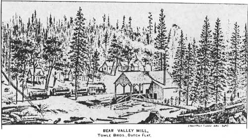
|
| BEAR VALLEY MILL, TOWLE BROS., DUTCH FLAT. (Thompson & West 1882: 369) |
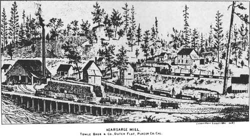
|
| KEARSAGE MILL, TOWLE BROS & CO., DUTCH FLAT, PLACER CO. CAL. (Thompson & West 1882: 368) |
The Towle Brothers had a novel way of loading the cars. Those logs lying near the railroad were hauled onto the cars by pulleys and ropes.
Other places cars are lowered down a tramway into the canyons, loaded with logs, tightly secured, and again hoisted to the road. On the 'flats' logs are hauled by oxen, of which 150 head are employed. Above the railway, chutes are constructed . . . in other places less precipitous, skid roads are built, by laying small logs like ties on a railway track. Logs are fastened together and resemble a train of cars as they are dragged by oxen along these skid roads. (Sacramento Union 6/16/1882: 1/6)
Thus, the Towle Brothers used almost every form of logging transportation used where water was not available except for the big wheel.
Logging railroads were not built with the same care or precision as were standard gauge passenger and freight lines that were meant to be permanent. Location of timber dictated the route:
As one side is logged off, the tracks are withdrawn and then extended elsewhere into virgin sections. Unlike the commercial mainline, it is designed only as an out-and-back proposition and planned solely to accomodate timber . . . logging economy dictates the shortest, cheapest route . . . timber trestles substitute for costly earth fills, and the track is laid around a prominence rather than thru [sic] a cut. Generally following natural drainages, it is a twisting way whose every mile is determined by the board feet of timber it would reach. (Floyd 1967: 92)
Economy also dictated that they be lightly constructed, "particularly feeder lines to more remote camps" (Myrick 1962: 441).
Logging camps within the forest were temporary affairs, and were moved as the available supply of timber was logged off. In addition, cutting in the mountains was highly seasonal, as the deep snows of winter made logging impossible "In the Winter all the men are discharged, and the work suspended, to be resumed again in the Spring" (State Minerologist 1882: 208). Many of the laid off lumbermen found employment in the ice industry around Truckee during the winter. The size and structure of the camps varied, and it was not uncommon for an entire camp to be moved to a new timber stand once work was completed (Nelson-Meggers Interview, 1982).
Sawmills were of two kinds: water and steam powered. While the early mills were often water powered, steam powered sawmills became common after 1868.
The typical mountain sawmill is located in some convenient valley, to which a small stream of water is conveyed by ditch or flume, for the use of the engine. The mill is covered by a roof of rough boards, while the sides are open. The building is generally constructed after the engine and saws are set, the boards being cut by the mill, and the house built over the machinery. The mill is generally, if not always, driven by a common steam engine of sufficient power. (State Minerologist 1882: 207)
Extensive mill ponds were usually built at the largest mills, and were used in winter for the ice harvest.
Many of the leading lumbering operators in the Forest have been previously mentioned. In 1889, a roster of the "Pine Cut in the Truckee Basin" described their output.
| Boca Mill Company | 7,000,000 feet |
| George Shaffer | 5,000,000 feet |
| Pacific Lumber and Mill Co. | 5,000,000 feet |
| Richardson Brothers | 3,500,000 feet |
| E. Ellen | 3,500,000 feet |
| Truckee Lumber Company | 3,000,000 feet |
| Lewison and Smith | 3,000,000 feet |
| O. Lonkey | 3,000,000 feet |
| Essex Mill Company | 3,000,000 feet |
| (Vivian 1890: 469) | |
The same publication listed operating sawmills within the Forest in 1890. Three were in Downieville, two in Sierra City, two at Emigrant Gap, two at Etta, one each at Alta, Boca, Mountain House, North Bloomfield, Pike City, Rocky Point, and six at Truckee (IBID: 470-72).
One of those mentioned at Truckee was the George Shaffer Company. Shaffer, as noted above, began operating in the area of Truckee in 1868 cutting ties for the railroad, By 1872 his mill works were in Martis Valley, as well as one mill in Truckee. He built a V flume three and a half miles into Truckee. His operation continued for a long time. The Truckee Republican noted in September, 1905 that the old Shaffer mill had burned, along with its contents, flumes, and a part of the mill pond dam (Truckee Republican 9/2/1905).
The fact that Shaffer's mill burned in 1905 is in a sense symbolic. Between 1881 and 1909 seven of the biggest operations in the Truckee Basin ceased operation; companies "who during the seventies had transformed this area from a vast primeval forest into a region of sawmills: Yerington and Bliss, George Shaffer, Richardson Brothers, the Truckee Lumber Company, Elle Ellen, the Boca Mill Company and the Pacific Wood and Lumber Company" (Knowles 1942: 32).
Shaffer had built a plant in Martis Valley in 1881, complete with mill, cottages for the workers, artificial log pond, flumes, and ox-teams to haul in the logs. Further expansion into new areas and the construction of new mills was undertaken in 1883; by 1892 a logging railroad was necessary to bring logs to his mills. The fire in 1905 ended the Shaffer operation. Richardson Brothers closed down their operations as well; they, like the Lewis Brothers, had used steam wagons to haul their finished lumber from mill to Truckee. The Truckee Lumber Company logged out their land and then shifted operations to near Oroville. Elle Ellen shut down in 1901, after years of production of ties and cordwood for the railroad. The Boca Mill Company closed its mill in 1908 after having logged out their lands; near the end the logs were cut at increasingly distant stands. Pacific Wood and Lumber operated near Brockway on Lake Tahoe until 1894; the main building burned in 1903 (IBID: 33-38).
There is a common thread running through the story of logging in the Truckee Basin: the fact that as the nearby stands of timber were exhausted, logging became much more expensive and thus less profitable. In addition, after 1900, the era of great railroad building was over, and the market for railroad wood tightened. Smaller mills continued to operate, clearing up small stands of timber, but by 1910 logging in the area was undertaken by far fewer companies.
As earlier mentioned, activity on the western slope centered around the railroad line and mining areas. In 1888, in Placer County, it was noted that "the Forest Hill Divide has been well timbered, but most of the timber around the mines has been cut off." In Nevada County, the same report noted that within a radius of five miles of Nevada City and Grass Valley "all of the original timber has been cut off." Mines were the major consumers. "There has been about as much timber used in the mines of the county as has been sawed by the mills. When using steam power, the mines burnt pine wood exclusively, but now water power is used." Like the Truckee Basin, the forest showed the effects of intensive cutting by the 1880s, (State Board of Forestry 1888: 169-172)
A discussion of the timber industry during the nineteenth century brings to mind steam mills, logging camps, flumes, and lumberjacks. There was a small scale timber industry on the forest that usually is ignored in the popular view: shake making. Shake makers made the long, thin, shingle-like pieces used for roofs and siding on mountain cabins and barns, and as fruit tray bottoms by orchardists. A shake was usually made of sugar pine, and measured thirty-two by five inches. They were typically three sixteenths of an inch thick at the thin edge (Berry 1913: 388-92). Shake makers were considered very destructive. The California State Board of Forestry discussed their practices in 1888:
The shake-makers can be found throughout the Sierras, generally a shiftless set who cannot bear the restraint and superintendence of manual labor in populated districts, preferring rather to lead a free and careless life in the mountain forests . . . Scenting out a Sugar Pine as easily as a terrier does a rat, they visit every district in the Sierras. (State Board of Forestry 1888: 156)
The report called them "forest pirates," because they cut down many trees but only used a few.
Shake makers were an independent sort. The job required a high degree of skill and practice. Several steps were required. First, trees were selected for long, straight grain. A tree that looked as if it was usable would have a six inch block chopped out to test its splitting qualities. If the tree was found worthwhile, it was felled and cut into shake length blocks. Shakes were split out with a shake froe, a long blade with a handle on one end. Once cut, the shakes were stacked, dried, and bundled for shipping. Shake makers wasted a tremendous amount of wood, and their activities were made more destructive by the fact that they culled the finest timber from the forest. Shake makers were generally replaced by tray mills, which made shake-like pieces, but used a much higher percentage of each tree. By 1913, only old men were active, and the Forest Service made regular sales to them; this industry has since died out (Berry 1913: 389-390).
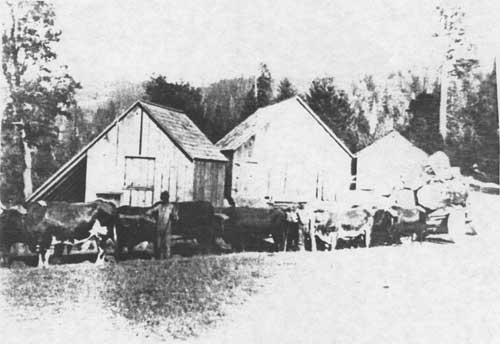
|
| M. L. MARSH OX-TEAMS AND BARNS |
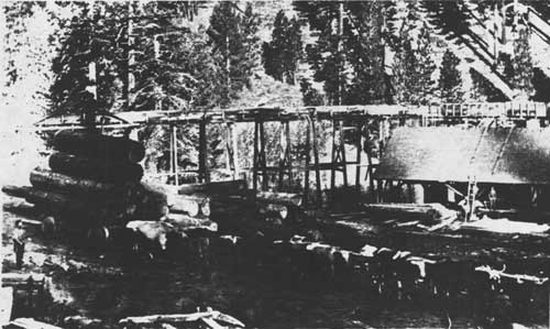
|
| M. L. MARSH SAWMILL. NOTE FLUME AND OX-TEAMS. |
Agriculture in the Tahoe National Forest, 1859-1906.
Agriculture during this period can be divided into two general categories: settled agriculture on farms of varying size within the Forest; and grazing use of forest range lands by livestock and dairy ranchers on a seasonal basis. Areas of permanent settlement included scattered small farms or ranches near mining towns and stage stations, as well as large farming regions like the Sierra Valley that supported year-round agriculture. These ranches typically provided food and fodder for the mining towns and logging camps nearby, and were able to gain access to larger markets once the railroad was completed if near enough to the line. The use by seasonal grazers was much less dependent upon local market conditions, especially as most of the animals in summer pasturage were destined for distant markets at the end of the grazing season.
The livestock industry within the Forest was of three general kinds — beef cattle, dairy ranching, and sheep. In general, these were all seasonal users of the mountain pastures, and involved the importation of animals from winter feeding areas. Some seasonal grazing was, of course, carried on by ranchers and farmers settled within the Forest.
The beef cattle industry dates back to Spanish and Mexican days in California; the first cattle in the area of the Forest were probably those brought in by immigrants before the gold rush. The gold rush also stimulated the cattle industry in the Central Valley and coastal counties because of the market provided by the miners. Unfortunately, the 1850 census gives no information regarding the number of cattle or sheep in the state; figures begin appearing after 1860. In the three counties that make up the greatest portion of Tahoe National Forest — Nevada, Placer and Sierra — figures for cattle between 1860 and 1900 seem to show a gradual increase after 1870, the lowest year in the count.
Cattle, 1860-1900
| 1860 | 1870 | 1880 | 1890 | 1900 | |
| Nevada County | 4,392 | 2,304 | 4,053 | 7,328 | 7,288 |
| Placer County | 12,269 | 4,138 | 4,682 | 9,287 | 6,602 |
| Sierra County | 282 | 3,342 | 3,945 | 4,952 | 7,308 |
Unfortunately these figures can only be viewed as a general indicator of historical trends. They are suspect because it is unknown what time of year the livestock was enumerated, how complete the surveys were, and most important, where the cattle were concentrated.
By the late 1860s, a pattern of range use was developing where valley or foothill ranch owners used the public lands in the mountains on a seasonal basis. The early eighties most likely represents the date when the "full stocking of the range lands of California probably should be dated" (Burcham 1956: 277). In 1899, a government inspector of forest reserve lands in California noted that "cattlemen claim to own large tracts of mountain land, a portion of which is fenced, but the larger portion is unfenced forest land. Simple cabins are maintained on the fenced portion of the range and the holdings of the riders who follow the drifting cattle" (Sudworth 1900: 510-511). Such use of public range lands had long been a custom in the California livestock industry:
Americans brought to California a philosophy that public lands may be used by private individuals. It seems that this is true particularly in the case of use for grazing. In the first half century of settlement and development there was virtually no regulation of this use of public land, although the legal fiction was maintained that graziers were merely tresspassers who might be evicted — or even prosecuted — at any time. However, it was common practice to obtain ownership of lands having sources of water for livestock or other strategic values, so that they thereby controlled use of contiguous public lands for grazing . . . By 1880 the period of free ranging on public lands had essentially ended, except for high elevation grazing lands in mountain districts. Here it continued until 1906. (Burcham 1956: 333,336)
The temporary, quasi-legal status of livestock grazing makes it particularly difficult to uncover information about pre-National Forest use in specific areas. It seems reasonable to think that most of the high mountain valleys were used for grazing during the latter decades of the nineteenth century. In 1882, it was noted that "the American Valleys are now used exclusively as summer pasturage for stock" (Thompson and West 1882: 406). American Valley is at the headwaters of the Middle Fork of the American River.
The beef cattle ranchers who are known to have used the public domain are largely those in the area around Sierra Valley. Many of the early settlers in the valley ran multi-faceted operations that raised animals, fodder, vegetables, and produced dairy products. The Italian-Swiss from Canton Ticino settled in Sierra Valley, at first in the Plumas County section in the 1860s; by the 1870s and 1880s they had begun to settle the Sierra County end of the valley (Raup 1951: 312). The Italian-Swiss, like the earlier, groups who settled in the valley, were interested in a variety of activities including raising beef cattle. A common pattern of immigration was that a new arrival would work for a rancher, save his money, and then purchase an improved ranch (Sinnott 1976: 94). A similar pattern was followed by other immigrant groups, including the Basques. In the area of Sardine Valley, Prosser Creek, and Sagehen Creek north of the Truckee River, a small number of ranchers ran cattle; here again the pattern was seasonal (Jackson 1967 a: 43-44; Mountain Messenger 1/16/1865).
In the Forest, the mountain valleys were the locus of dairy activities. Most of the dairies were in the northeastern portion of the Forest. There were also small ranches and farms elsewhere in the Forest that produced dairy products The Mountain Messenger, 1878, 1881, and 1885, described the McMahon Ranch on Lower Morristown Ridge as an example. The ranch was settled by the Edward McMahon family in the 1860s. The 1878 article noted "flourishing crops" and a considerable trade in dairy products. In 1881, hay and potatoes were sold, and by 1885 the family's cattle had largely been sold off. In the early 1880s the McMahon's, like many others, bought a home ranch in Brown's Valley in Yuba County, and used the Sierra County area seasonally (Sinnott 1976: 179).
The major area for dairying was east of the Sierra Nevada in Sierra Valley and the valleys between Sierra Valley and Truckee. Ranchers in this area, as was the case elsewhere in the Sierra Nevada, grazed their cattle in fenced alpine meadows (Sudworth 1900: 54). In October, 1869, the Mountain Messenger 10/23/1869) discussed the industry in valleys adjacent to Sierra Valley.
'Grazing in Mountain Meadows.' Considerable quantity of butter and cheese is being taken to the railroad for shipment. Large herds of stock are being driven every Spring to mountain meadows to graze during the Summer. This region is the most delightful in the world for a summer residence. All that is needed is for grazers to build substantial houses . . . instead of living in camps. During the winters, which are long and dreary in that region, they could return to their houses on the plains. Sierra Valley is already quite thickly settled with an enterprising population, who are prospering in their agricultural pursuits. Long Valley, Sardine Valley, and some others, are quite extensive, but as yet contain few settlers.
North of Donner Lake, dairy ranches began to be developed after 1870. Prosser and Son operated a 100 acre ranch, raising hay and dairying with the aid of hired help. Tinker and Fenton were listed as having eighty acres and a number of cows. Tinker apparently ran a stage station on the Dutch Flat and Donner Lake Wagon Road, and ran a dairy in addition to his inn (Jackson 1967a: 39). The Stampede Valley (now largely inundated) was first settled by summer dairy ranchers after 1865 or 1870. Among the first was John Fleckenstein. By 1880, he rented 640 acres of land, and paid $1,800 in wages in 1879, sold seventy of his seventy-five calves, and made 1,500 pounds of butter. "The butter was all made in the summer, brine was poured over it to keep it fresh, and then the entire production was sold in the fall" (IBID: 40). Other dairy ranches in the Stampede Valley included Dog Valley Ranch, Woodward, Bill Williams Ranch, and the Perazzo and Hoke dairies. These dairies all operated from 1870 through 1890, and unlike some of the Sierra Valley operations, were characterized by seasonal use. The herds and ranchers returned to the Central Valley in the winter (IBID: 41-44).
W. F. Edwards described the Truckee Basin in 1883 as "the dairyman's heaven." During the summer months, Sacramento Valley ranchers brought their "droves of milch cows, lots of choice pigs, coops of poultry and herds of calves" into Squaw Valley, Twin Valley, Lake Valley, Russell Valley, Martis Creek Valley, Prosser Creek Valley and numerous other small valleys. Each valley had "their ranches, which, when the season gets in, are occupied by old and experienced butter men, who bring all the modern appliances in the way of patent churns, improved setting pans, etc." According to Edward's count, fifteen to twenty dairy farms were located near the Truckee River; there was "not a nook, or vale but is known to the dairymen and occupied." Most of the Truckee butter produced in the early 1880s was marketed by Nelson Martin and Sisson, Crocker and Company; cheese factories were just beginning to be introduced into the region (Edwards 1883: 69-70).
The sheep industry in the forest paralleled cattle, in the sense that it was largely a summer, seasonal activity. However, sheep had a great effect on the livestock industry because of the destruction caused by the bands in the mountains. The depredations caused by sheep turned public opinion in the mountain counties and in western states toward regulation of grazing, and was at least to some extent responsible for the establishment of national forests by the federal government.
In 1849, there were only 17,000 sheep in California. By 1860, there were over 1,000,000, the increase resulting largely from the demand for meat during the gold rush. Before 1870, sheep were kept largely in the same location year round, but as numbers grew so did the requirement for new grazing grounds. By 1872, Southern California sheepmen explored Nevada grasslands as a new region for grazing, but this plan was not successful at that time (Ellenwood 1915: 585-587).
The following table provides information regarding the number of sheep within the three counties that make up the bulk of the forest.
Sheep, 1860-1900
| 1860 | 1870 | 1880 | 1890 | 1900 | |
| Nevada County | 1,147 | 504 | 2,791 | 1,936 | 3,142 |
| Placer County | 23,280 | 26,596 | 58,805 | 62,161 | 32,432 |
| Sierra County | 55 | 502 | 1,151 | 12 | 1,726 |
| (Burcham 1956: 414-416) | |||||
Sheep figures referred to in this table are, at first glance, skewed heavily toward Placer County. There are a number of possible explanations for the wide variations in counts. First, Placer County has extensive areas within the Central Valley upon which ranches were located, and was at the upper end of a circular route from southern California through the Sierra Nevada taken by sheepherders during the late 19th century. Second, the low numbers in Nevada and Sierra counties may have reflected the confusion often envinced by livestock ranchers between census takers and assessment of property for tax purposes. In addition, as grazing areas were opened in southern Oregon and Nevada, new patterns of yearly grazing developed that brought animals into the northern counties of the forest. It is known that total numbers of sheep in California declined between 1880 and 1890 (Ellenwood 1915: 587-588). One reason for the decline was a series of great drives of flocks from California into the intermountain states. After 1890, the number of sheep statewide declined largely because former sheep ranges were being put to other uses (Ellenwood 1915: 588-589) "Establishment of National Forests in 1905, and the grazing fees which they began to assess in 1906, were further setbacks to the sheepmen" (Burcham 1956: 273).
Regulation of grazing on the public domain by agencies of the federal government had its roots in a number of causes, not the least of which were the fires that sheepmen set as they left the range each fall. In 1902, P. Y. Lewis, a pioneer sheepman, described his use of the mountain grazing lands in 1876-1877.
When we turned back toward the foothills, we started setting fires and continued setting them until we reached the foothills. We burned everything that would burn, such as brush, young timber and grown timber, setting the fires behind the sheep as they grazed back over the range the second time. The sheep moved but a short distance each day and we spent a large part of the time in setting the fires. The sheepmen on the neighboring ranges set fires about the same time as we did, and in the latter part of the season there would be fires as far as a person could see. Large tracts of excellent timber were destroyed and became brush fields later, but the sheepmen did not care as it was thought that fires improved the feed and removed the timber which interferred with the sheep. (Lieberg, 1902: 10)
This practice was objected to by a wide range of persons, from timbermen to local residents and state officials. The San Francisco Chronicle (8/27/1887) noted from Sierra County that "much feeling is manifested in this part of the country (Sierra City) against sheep herders, who it is believed start most of the forest fires raging through the mountains." The State Board of Forestry reported in 1888 that while some fires were caused accidentally by teamsters, sheepmen started most.
The most disastrous fires, from a forest point of view, are unquestionably those started by the sheepherders who drive their flocks into the high regions of the Sierra to feed during the summer months. These men, ignorant and shiftless, as a rule, do not comprehend the magnitude of the injury inflicted on the forests by fire, and looking upon our vast mountain ranges as 'no man's land,' think that it does not matter in the least how they treat them. A great many of those herders, especially those who return year after year to the same grazing regions, set fire to the undergrowth upon leaving in the fall, so as to improve the herbiage of the following spring and summer. Removed as they are from all human habitation, they are free to commit whatever depredations they please.
The report suggested that the state strictly regulate grazing by dividing the forests into districts, with permittees liable for fire damage. Until the state controlled grazing, warned the forestry board, "there seems to be but very little hope of preventing fires in our mountain forests" (State Board of Forestry 1888: 154).
In 1902, a Department of Interior inspector noted the lack of progress made by officials in controlling fires started by sheepherders. "The fires along the main divide of the Sierra north of Beckwith Pass found burning in July, followed exactly the movements and progress of the sheep camps" (Lieberg 1902: 10). Fires had destroyed an area fifteen to twenty miles wide and running from Table Mountain in Butte County through Plumas County, across the Yuba River Basin, the Bear River Valley, through the basin of the American River to the Rubicon River and on to the south (IBID: 1902: 9).
Sheep raising by ranchers owning property adjacent to or within the boundaries of the Forest was apparently not extensive. In 1871, W. C. Lemmon was the only Sierra Valley resident with a significant flock. County assessors noted a total of only 700 sheep in the valley. Sheepherders from Nevada and the Sierra Nevada foothills were the primary users of the range around Sierra Valley. In 1870, approximately 5,000 sheep were grazed nearby (Sinnott 1976: 93). Only one rancher was noted in the Stampede Valley area as specializing in sheep, which "made him something of an 'outsider' in the community" (Jackson 1967: 43). As years passed more emphasis was put on sheep raising on the eastern slope of the mountains. In the early 1900s, Fred Blinman of Sierraville had a flock of 2,000. The fact that so many of the sheep on the forest were from outside the area was illustrated by the fact that in 1906, 47,000 sheep owned by Reno and western Nevada ranchers were apparently temporarily barred from grazing on the range in Sierra and Yuba counties by the Forest Service. Eastern California ranchers who feared that overgrazing would permanently damage the range had been protesting the range practices of migratory sheepherders for many years (Sinnott 1976: 93 ).
Many of the sheepherders who used the public domain at this time were Basques. They had begun to arrive in California with the discovery of gold; many mined, and by the mid-1850s, some began to raise sheep. By the end of the 1850s, Basque sheepherders were well established in southern California, and began the practice of using the high mountain pastures in summer and low desert areas in winter, a practice similar to that used in the Pyrenees. The first were itinerants who packed their belongings with them on a burro. When their bands increased, many sent for a relative from their homeland, and paid the assistant in ewes. As the assistant's flock increased, he simply struck out on his own, and both repeated the cycle. This quickly caused overcrowding on the range. By the 1870s, their flocks reached northern California. The itinerant shepherd had by law the same right to the public domain as ranchers settled in the area, who customarily divided range rights among themselves. It was the settled ranchers who lobbied for the establishment of national forests, and, later, for the Taylor Grazing Act. Eventually boards of local ranchers made decisions regarding permittees and acted to shut out the wandering Basques (Douglass 1980: 59-61).
As noted previously, stage stations had small fields and orchards to provide fresh food for guests. The Howard House and Ranch (later known as Bassett's Station), on the Yuba Gap Trail six miles above Sierra City, was such a combined enterprise (Mountain Messenger 5/6/1865). A similar operation was run by Jerome Fordyce in "Meadow Lake dam valley" where he would board horses, mules, and cattle for $3.00 a month. Fordyce's advertisement stated that he grew the "best quality grass clover and timothy up to a jackass in Fordyce Valley" and was able to support 500 animals (Virginia City Union 9/2/1865).
An example of a ranch adjacent to a mining area was the Lavezzola Ranch, six miles northeast of Downieville. The Lavezzola family established a farm there after emigrating from Genoa, Italy, in 1859. The family bought a squatter's right to 160 acres of a Mr. Wilson's homestead, of which fifty acres was cultivable. Two of the three sons, Peter and Daniel, remained on the farm; another, Antone, purchased the St. Charles Hotel in Downieville in 1904; he also owned shares in quartz and gravel mines (Woolbridge 1931: 344-5). Similar ranches were scattered around Sierra County (Crossman and Cochran 1867: map).
There were small ranches in the area of Washington in Nevada County. The History of Nevada County (1882) listed six ranches within Washington Township, with improvements valued at $7,400 (Slyter 1972: 78). The Nevada Daily Transcript in 1890 mentioned four ranches around the town.
The soil for tillage is limited, but rich. Messrs. Brimskill, J. Grissel, Millerick and Murphy, have orchards with fine fruits. The potatoes are sweet and mealy. The apples, pears, and peaches, have a fine mountain bouquet, juice and flavor. Pork raised here are excellent. (Quoted in Slyter 1972: 78)
The Chinese living near Washington raised much of the vegetables produced nearby. In May, 1870, "a gentleman from Washington informs us that in the vicinity of the village of Washington there are over 100 Chinese and that they outnumber the white population" (Nevada City Daily National Gazette 5/14/1870). Some of these people farmed; the Daily Transcript remarked in 1890 that "the Chinese have almost a monopoly on gardening vegetables" (quoted in Slyter 1972: 79).
Some of Placer County's high mountain valleys were used for farming. Squaw Valley farms raised hay, vegetables, berries, and produced butter, cheese, and eggs for sale in Lake Tahoe hotels, area sawmills, and in Nevada (Thompson and West 1882: 406).
In 1870, Sierra County had 2,602 acres of hay producing 2,602 bales; in 1880, 11,640 bales were raised. Figures for other counties with land in the Forest are available, but are difficult to assess because locations within each county are not given (Vivian 1890: 300-303).
Agricultural water development during the period 1859-1906 was limited on the western part of the Forest to the delivery of water to foothill areas by former mining water companies. This was further stimulated by the Sawyer Decision in 1884 that ended hydraulic mining, and the Wright Act of 1887 that allowed for formation of irrigation districts. The South Yuba Canal Company delivered water to foothill farms before the development of the Nevada County Irrigation District. This change had been discussed in the 1860s when it was noted that mining would be temporary and that irrigation would stabilize water use patterns on the long term (Pagenhart 1969: 161).
The development of water use in the Tahoe-Truckee basin was much more complicated. Use of the Truckee River was considered crucial to the future of agriculture in the Washoe Valley and lumber companies used the river to transport lumber destined for the Washoe mines and Comstock. Naturally, as a major source of fresh water flowing into western Nevada, it was considered crucial to Nevadans (Jackson and Pisani 1973: 1).
An enduring struggle over the use of Lake Tahoe's water began in 1865, when "a San Francisco hydraulic engineer, Alexis Von Schmidt, formed the Lake Tahoe and San Francisco Water Works Company" to tap the Truckee to supply water to San Francisco and other towns along the proposed aqueduct (Pisani 1975: 38-42). The formation of the company started a sixty-four year long controversy over the water in the Truckee Basin. Californians criticized the plan, which included a tunnel from Squaw Valley to the North Fork of the American River and an aqueduct from the river to the Bay Area, as too expensive and potentially damaging to the Truckee River logging operations. Nevertheless, Von Schmidt doggedly pursued his plan, building a diversion dam near Squaw Valley. Support for the plan and its required bonds were voted by the San Francisco Board of Supervisors; this was, however, overruled by the Mayor in 1871. After 1871, the Von Schmidt plan was no longer seriously considered (Jackson and Pisani 1973: 3-5).
Use of the water in Lake Tahoe and the Truckee River by farmers in western Nevada was made more certain by the passage of the Newlands Reclamation Act in 1902. A complication had arisen because of the fact that the State of California in 1870 had given permission to the Donner Boom and Logging Company (a subsidiary of the Central Pacific Railroad Company) to build a dam to regulate the flow of the Truckee in order to better run logs on the river. This right was later obtained by the Truckee River General Electric Company, which in turn absorbed smaller electric companies along the river. Thus the use of water in the area came under four major interests: the U. S. Reclamation Service; Nevada farmers; power companies and mills along the Truckee; and property owners, resorts and inns on Lake Tahoe. As late as 1909, the U. S. Bureau of Reclamation was still fighting with Truckee River General Electric over the outlet dam at the lake and its schedule of releases which did not coincide with the needs of Nevada farmers (Pisani 1975: 37-142, passim).
Between 1859 and 1906, agriculture underwent a series of changes that resulted, in part in the establishment of government control over many of the resources used by agriculturalists. The free use of the public domain was characteristic of this period; but the controversy around overgrazing and fires led to grazing regulation. Water for agriculture also fell under government regulation, either by newly established irrigation districts in California or the efforts of the Newlands Project in western Nevada. Small scale cultivation established during the gold rush period continued; there is, however, no evidence of substantial expansion during the period.
Other Pre-National Forest Industries.
Although economic activities during the period between 1859 and 1906 were largely centered around mining, lumbering, and agriculture, there were other minor enterprises undertaken, mostly on the eastern side of the Sierra Nevada. Such activities were the ice industry, commercial fishing, and recreation.
The ice industry was most highly developed along the line of the Central Pacific Railroad and in the Truckee Basin. There was some small ice enterprises on the western side of the Sierra Nevada — "upon Rock Creek, northeast of Nevada City, ice has been produced for market since the earliest times" ("The Irrigation of Nevada County" 1923: 1). The main center of the industry was located, however, on tributaries of the Truckee River and around Donner Pass.
The growing population of California's major cities and the development after 1850 of a relatively stable population pattern led to the growth of a market for ice. This was originally met by wagons full of packed snow, which had been brought down from the mountains on muleback, and sold for $2,000 a ton in Sacramento (Itogawa 1974: 1-3). Some ice was harvested from creeks in 1854 by idle miners northeast of Georgetown on Pilot Hill and, as noted, on Rock Creek, but the ice demand was largely met by ice brought to San Francisco from Alaska by ship. However, the potential for an ice industry was noted as early as 1855 (IBID: 16, 23, 12-15). The Sierra Nevada ice industry developed greatly after the completion of the railroad across the Sierra.
Strong economic ties between the Central Pacific Railroad and the domestic ice companies stimulated a degree of mutual dependency; the railroad's demand for refrigerator coolant and the ice company's requirement for rapid transportation established a close working relationship. (IBID: 25)
In fact, the railroad established an ice company as a subsidiary in 1868. The railroad selected Joseph M. Graham, an assistant construction engineer, to survey for and build the ice works.
They organized the Summit Ice Company for filling their ice houses. They built the ice houses at some little lakes south of Summit Valley and struggled for about three winters to make ice . . . During that time, I learned that the temperature down the Truckee River near Boca was some 20 degrees lower than it was registered at Summit. I then made surveys of Prosser Creek near Boca and found that we could build a dam 35 feet in height. It would give them a reservoir of 42 acres, which was more than sufficient for their ice house. The Summit Ice House immediately abandoned all their works in Summit Valley and constructed ice works at Prosser Creek. (Kraus 1969: 186-187)
In 1882-83 the Summit Ice Company was estimated to have put up some 50,000 tons of ice (Edwards 1883: 32).
Boca quickly became an ice center. "This industry utilized the area's clear, sweet waters, its relatively moderate snowfall, and its dry, frigid winter temperatures to produce great quantities of what was probably the hardest and best natural ice to be found on this continent" (Goodwin 1979: 3). Between 1868 and 1874 several companies established works near Boca. The Summit Ice Company built a semi-circular ice house along a bend of the Truckee that measured 450 by 50 feet, and used the river to float blocks from their ice field to the storage house. The Boca Mill and Ice Company, organized by L. E. Doan and the Sacramento lumber company of Friend and Terry built an ice house in 1869 measuring 484 by 40 feet and with a capacity of 8,000 tons. "The mechanics of filling the ice houses at Boca required an elaborate system of tramways, trestles, and steam elevators. Blocks of ice, elevated to a height of fifty feet, descended the trestle into the ice houses" (Itogawa 1974: 28-29). The Nevada Ice Company, organized in 1870, built ice works at Camp 16, one mile east of the mouth of Prosser Creek (Edwards 1883: 32). They later were forced lower in the basin by weather. The Nevada Ice Company's works included two endless belts and other equipment to pack their ice house with 10,000 tons of ice. In 1873, the company got the rights to harvest ice at Shaffer's Mill on Martis Creek, hauling the blocks out by wagons after attempts at using the lumber flume reduced the eleven inch thick blocks to three inches. In 1874, the People's Ice Company began harvesting near Shaffer's Mill, and near Camp 20 east of Boca. They built two ice houses with a total capacity of 8,000 tons (Itogawa 1974: 29-31).
The ice harvesters used the same tools as used in the eastern ice industry, as well as locally designed and manufactured equipment. These included ice plows, scrapers, ice markers, and saws (IBID: 33-34).
Ice was harvested from man-made ponds and from ponds adjacent to lumber mills that had closed for the winter. Typically ice was not considered ready to harvest until it was at least ten inches thick, which usually took one month from the time that ice first appeared. Just before that time the ponds would be cleared of floating debris by dragging the surface with a float. As winter temperatures froze the pond, ice workers would keep the surface as clear as possible of an insulating blanket of snow; as soon as the weight of horses could be supported, scrapers were pulled across the ponds. "The shaving machine, equipped with rectangular shaped blades suspended from the undercarriage of horse drawn sleighs, effectively shaved off the final layer of snow ice" (IBID: 33-34). Ice was then scored for cutting, which was done in checkerboard fashion, each square twenty-two inches on a side.
The pattern outlined on the ice represented a guide for the ice plows to inscribe deeper incisions. Ice plows resembled early farm implements, modified only with a four foot long steel attachment equipped with seven individual teeth. Each tooth is a quarter of an inch longer than the first. One pass of the plow deepens the furrow by an inch and three quarters. Repeated incision of each furrow deepens the groove to a sufficient depth to insure proper separation of the ice blocks. The unsevered segment was then manually separated with a four foot long hand saw. (IBID: 35)
Workers cut the slabs into proper size blocks and floated them to the head of a tramway from which the cakes were sent to the desired ice house for storage (Edwards 1883: 31). Once in the icehouse, blocks were covered with an insulating layer of sawdust obtained from local sawmills and stacked as tightly as possible. Railroad spur lines were built to facilitate loading ice on cars for transportation to market. Each car carried about ten tons (Itogawa 1974: 36-38).
Ice harvesters were from two groups: local lumbermen laid off seasonally; and transient workers arriving for work in the ice houses. The transients used the railroad to get to Truckee, some from the Pacific Northwest and others from Mississippi Valley. Chinese workers were also hired, but the antagonism of white workers made this relatively rare (IBID: 42-44).
By 1876, the development at Boca peaked with the construction of the Boca Brewing Company (Tahoe National Forest Historical Files). In 1888, another ice dam was built for the ice business. Use of ice was described by the Loyaltonian. Sixty carloads were sent to San Francisco and Los Angeles, and "great quantities of ice will be kept at these points for the purpose of icing fruit cars during the summer. The ice men expect that the season's cut of ice will reach 100,000 tons in the vicinity of Truckee" (Quoted in Sinnott 1976: 208). Over 1,100 men were employed in the harvest of 1903 (Mountain Messenger 12/12/1903).
Commercial fishing, like the ice industry, was given a boost by the completion of the transcontinental railroad. Fish caught in Sierra Nevada lakes and rivers could be quickly transported fresh to the Washoe mines, Sacramento, and San Francisco. Fishing for mountain trout was common along the Truckee River, and fishermen complained that sawdust and other pollution from sawmills in the canyon damaged the fishery (Pisani 1975: 70). The catch in Donner and Independence lakes, and along the Little Truckee River was such that the State Fish Commissioners ordered that the lakes and river be stocked in 1878, 1879 and 1880 with eastern trout, salmon, and whitefish (State Fish Commissioners 1879: 9-12; 1883: 7). The catch continued to grow, and the Commission, with the cooperation of Sierra and Nevada counties, passed regulations outlawing fishing until the spawning season had passed. In 1893-94 "the Commission caused the arrest and prosecution of the professional fishermen who operated at Independence Lake during May, contrary to the ordinance" (State Board of Fish Commissioners 1895: 20). The poachers were not convicted, but the arrests had the affect of stopping out of season fishing on the lake. The fishermen caught their fish through the ice and sold their catch in San Francisco (IBID: 20). Commercial fishermen were active on most of the Sierra Nevada lakes during this time, including Tahoe, Donner, Webber, Independence, and others (State Board of Fish Commissioners 1886: 7). The Commissioners noted in 1893-94 that "a considerable number of trout are annually caught by market fishermen on Donner and Independence lakes and the Truckee River and are shipped to the San Francisco market," enough that the annual spawn was threatened (State Board of Fish Commissioners 1894: 31).
One of the earliest service industries on the Forest was recreation and a number of resorts were developed in the last half of the nineteenth century. As noted previously, Dr. David Webber opened a resort on Webber Lake in the early 1850s that was accessible via the Henness Pass Road. Webber bought the land around Webber Lake in 1852; the lake was then known as Truckee Lake. He built a lodge, cottages, stocked the lake with trout, and had boats and horses for the use of the guests. During the Meadow Lake excitement, his business flourished, and in the 1870s he opened a private school for his guests during the summer months. Unfortunately for Webber, as the Meadow Lake excitement faded and the railroad replaced Henness Pass Road, the number of visitors fell off drastically (Sinnott 1976: 8).
Similar resorts were located on Independence, Donner and Lake Tahoe. Augustus Moore established a resort hotel at Independence Lake in the 1860s that included a small boat for the use of his guests. Like Webber, Moore's hotel was on the Henness Pass road (Moore MS. Bancroft Library: 24). Small resorts and hotels were established on Donner Lake in the 1860s as the roads and railroad through the region opened easy communication. Among these were Lake House, Donner House, and Donner Lake House. "One traveler thought Donner Lake 'a haven of peace, in the shape of as fine a stopping place, so far as good meals go, as can be desired'" (Jackson 1967a: 30-31).
One of the most famous of all early recreational developments in the Forest is Summit Soda Springs, originally chosen by Mark Hopkins for summer residence in 1872. The site is on the National Register of Historic Places (Summit Soda Springs, National Register of Historic Places Inventory — Nomination Form 1977). The buildings on the site were described in 1977.
The building and structures which remain today are two guest cottages, the 'Hopkins Cottage,' the stone chalet, log barn, soda well houses, tool shop and old concrete fountain built as a scenic attraction for the old hotel. Miles of original stone walls built for livestock, and cobblestone pathways leading in and around the buildings and meadows further refine the setting and contribute to the original in tent of the complex — that of serving as a summer retreat for the Hopkins family. The entire complex retains its original integrity.
The area was leased by the Central Pacific Railroad in 1872 to William Jones who built a three story hotel with a capacity of eighty-five guests. Many prominent Californians of the time were attracted to the resort (IBID: 4).
Like other mountain lakes, Lake Tahoe became a popular resort area after the 1860s.
Very early there were those who sensed the possibilities of the Lake Tahoe region as a pleasure and health resort. With increasing frequency pioneer vacationists from Nevada and elsewhere were lured to the place by the beauty of the lake as well as its hunting and fishing facilities. (Hoover, Rensch and Abeloe 1966: 266)
Cabins were built at a variety of points around the lake; these were followed by the development of resorts like Hunter's Home, built in the 1860s by John W. McKinney on McKinney Creek (IBID: 266). Further resort building followed, and by 1900 the lake was a popular resort and vacation center for many of California's most prominent citizens.
| <<< Previous | <<< Contents>>> | Next >>> |
|
region/5/tahoe/history/chap4.htm Last Updated: 06-Aug-2010 |