|
For The Trees An Illustrated History of the Ozark-St. Francis National Forests 1908-1978 |
|
Chapter 2
The Roots of Forest Conservation
By the mid-1800's a few pioneers had begun to be heard in the field of forest conservation—Franklin Hough, the first man appointed to investigate the forest situation in the United States; Bernard E. Fernow, the first chief of the Division of Forestry; John Muir, one of the early voices for wilderness and for conservation; and Gifford Pinchot the first chief of the United States Forest Service. Pinchot was just beginning his significant career in federal forestry at that time. Such people, and others, initiated a series of actions which eventually led to the establishment of the National Forest System. In 1891, President Benjamin Harrison withdrew 13 million acres of Western land from the public domain. These areas became the first Forest Reserves, the nucleus of today's National Forests. (In 1907 the name Forest Reserves was changed to National Forests to more accurately reflect that the forests belonged to the nation and were to be managed to use the many forest resources.) [1]
Following the establishment of the Forest Reserves in the West, demands for similar reserves were made for the East and South. Arkansas, at the turn of the century, was one of the few Eastern and Southern states with extensive areas of public domain. President Theodore Roosevelt withdrew large areas of the mountainous portions of the state from further homestead entry in the summer of 1907. Roosevelt, on December 8, 1907, signed a proclamation establishing the Arkansas National Forest in the mountainous lands south of the Arkansas River. (In April 1926, this forest was renamed the Ouachita National Forest because some of the forest land extended beyond Arkansas into Oklahoma.)
The Ozark National Forest became Arkansas' second National Forest. This forest constituted the only protected body of hardwood timber in the country at that time. An early supporter of the National Forests in Arkansas was Harry E. Kelley of Fort Smith. Kelley saw the beginnings of a furniture industry in Fort Smith and knew this industry would depend on a perpetual supply of wood. The management and protection of the nation's forests was to Kelley one way to insure this supply. [2]
The National Forests of Arkansas
At first the two National Forests in Arkansas were administered from offices in Fort Smith. Samuel J. Record served as the first Forest Supervisor. Record went on to become a professor of forestry at Yale University. David Fitton succeeded Record and by the end of December, 1908, set up his headquarters office in Harrison, Arkansas. Fitton had just received a severe reprimand for the conduct of his personal affairs. Residents of the community in which Fitton had been living had complained and had Fitton not been posted already to Arkansas, he undoubtedly would have had to leave the Forest Service. [3] In those years, when the public was at best skeptical about the Forest Service, and at worst openly hostile to the National Forests, the Service demanded their officers be professionally competent, physically fit, and morally above reproach.
The selection of Harrison as the new headquarters proved to have many disadvantages for the Rangers and forest users of the Ozarks. It took more than half a day ride from most sites within the forest to reach Harrison. Some locations required a day or more of travel. Even telegraphic communication to the Sylamore Ranger District, east of Harrison required routing through Kansas City, Missouri. The decision to move to Harrison was based most likely on the availability of space there in the General Land Office rather than on considerations of convenience. An inspection report in 1909 recommended a more central location for the headquarters, but it was 1918 before the relocation to Russellville, Arkansas occurred. [4]

|
| Samuel J. Record, Supervisor for Arkansas National Forests in his office at Mena, Arkansas, September 10, 1908. Record was also the Forest Supervisor of the Ozark National Forest (established March 6, 1908). Photo No. 76568, by D.P. Johnson. |
|
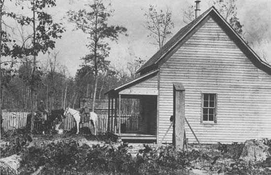
| Showing proposed Rex Ranger Station. Supervisor Fitton and Ranger Vaughn mounted. Photo No. 74509, possibly by Fitton, 1908. |
When Roosevelt added 600,000 acres to the Ozark National Forest, in February 1909, his action was less popularly received than the original proclamation. Homesteaders had become aggravated by forest officers who came to check the legitimacy of claims, or by those who examined boundaries, or those who prosecuted timber trespassers, or by those who used bloodhounds to track down woodsburners. A news article in the Waldron, Arkansas Advance Reporter, dated July 3, 1908, called the National Forests "a curse to the good citizens of Scott County" and expressed the hope that the forest would soon be abolished. Abolition of the forest became a part of every political candidate's platform, no matter what the public office.
A memorial resolution introduced concurrently in the Arkansas Senate and House of Representatives expressed the legislature's sentiments on abolishing the National Forests. In the Senate 16 Senators voted against the resolution, favoring instead retaining the National Forests. This vote, however, was reconsidered and the Senate voted in favor of the resolution—21 to 11— on April 15, 1909. [5] The House vote, taken on May 6, adopted the Senate Concurrent Resolution 57 to 20. [6] Such activity led to a series of land eliminations from the forest, beginning with a proclamation by President William Howard Taft on December 28, 1910. Taft withdrew 562,981 acres within the Ozark National Forest boundaries. Most of this land, however, was unperfected homestead claims; only ten per cent of this acreage had been vacant government land.
The basic administrative unit of the Ozark National Forest, as in all National Forests, is the ranger district. Gifford Pinchot, from the first, envisioned the Forest Service as a decentralized federal agency with forest supervisors and their rangers having authority to plan and implement policy for a given National Forest. Each National Forest is divided into geographic districts with a district ranger responsible for all activities and conditions within his district. These rangers report to the forest supervisor, and so on up the organizational ladder. Inspections have served over the years to authenticate, test, and measure field reports.
During the Ozark National Forest's first years, the district boundaries changed frequently because of acreage fluctuations resulting from land eliminations. Maps indicate how the district organization has changed, and present the current district organization. Even today, each district reflects the idiosyncrasies of its own history. (A profile of each ranger district appears in the appendix.)
National Forest supervisors report to regional, or as they were first called, district foresters. At first, the Ozark National Forest received its administrative direction from District 3, headquartered in Albuquerque, New Mexico. In 1914, the Ozark National Forest came under the direction of District 7 in Washington, D.C. Finally, in 1934, the Ozark National Forest became part of Region 8, the Southern Region, with headquarters located in Atlanta, Georgia. [7]
The work of the Ozark forest personnel at first centered around determining boundary lines, examining homestead claims, and protecting the forest from fire. Little land in the Ozarks had been surveyed and most claims not officially described. Additionally, some timber was sold and improvements begun. Building roads, installing telephone line, and locating and establishing fire lookouts got first attention. The first road built in the new forest was the Big Flat-Sylamore Road. H.R. Koen was the district ranger and work began under "Uncle Ben" Vaughan in 1913. [8] Ralph Huey served as superintendent on this project, photographing many stages of the construction. Later, land acquisition added another duty to the foresters' growing responsibilities. The first lands purchased for the Ozark National Forest were bought from the Missouri Pacific Railroad in 1919, under the authority of the Weeks Law, passed in 1911. This acquisition brought 42,198 acres into the National Forest. In all, land acquisitions amounted to 647,934 acres by 1978. [9]
|
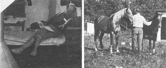
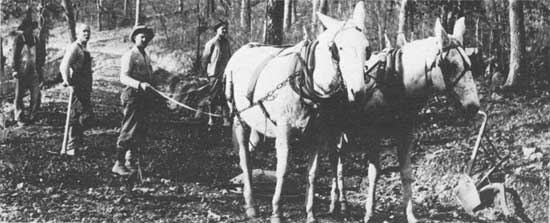
| Top left: Interior of sleeping and office tent. Ranger Vaughan on cot. Photo No. 19391A, by Ralph Huey, 1914. Top right: Wildcat Ranger Station cowshed constructed June 1914. Assistant Ranger Koen with his bay mare, Topsy, and Francis Kiefer's horse, Jim. No serial number. Photo by Francis Kiefer, 1914. Bottom: Finishing Big Flat-Sylamore road project at Culvert No. 1. Photo No. 19755A, by Ralph Huey, 1914. |
|
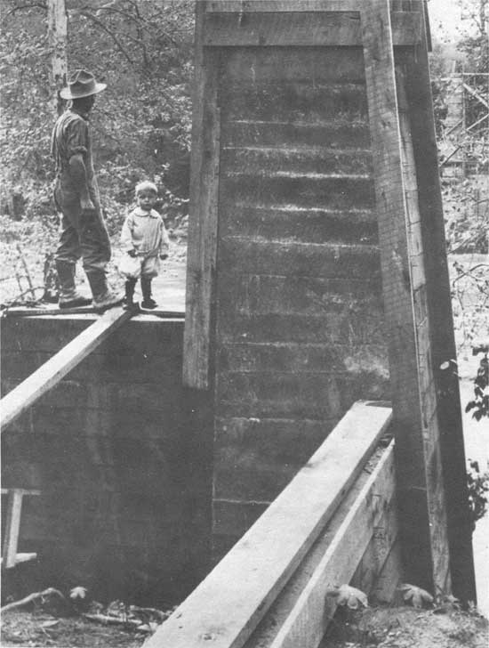
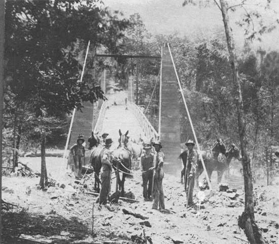
| Part of south tower of Sylamore bridge. Mechanic F. A. Huey on wall. Photo No. 19509A, by Ralph Huey, 1914. |
|
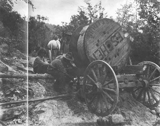
| Getting over sandstone ledge with bridge cable, 4100 lbs. at stake 78. Big Flat-Sylamore Road. Front bloster and reach broken letting front end (oak railroad ties) to ground. Raising with Jack screws to put wheels under again. Photo No. 19510A, by Ralph Huey, 1914. |
|
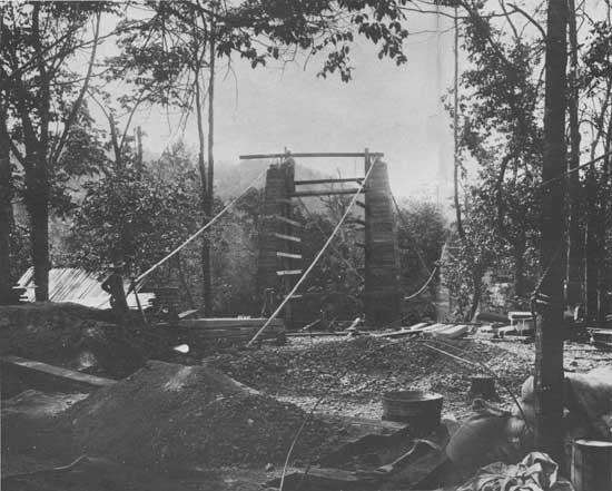
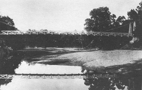
| Top: Placing cables on Sylamore bridge-concrete materials in foreground for south anchors. Photo No. 19512A, by Ralph Huey, 1914. Middle: Workman on the Sylamore bridge. From an unnumbered photograph in the history files of the Ozark National Forest. Bottom: Sylamore Bridge. Constructed by the Forest Service and settlers. Photo No. 19756A, by Ralph Huey, 1914. |
| <<< Previous | <<< Contents>>> | Next >>> |
|
8/ozark-st-francis/history/chap2.htm Last Updated: 01-Dec-2008 |