|
MESA VERDE
The Archeological Survey of Wetherill Mesa Mesa Verde National Park—Colorado |

|
A PROLOGUE TO THE PROJECT (continued)
DOUGLAS OSBORNE
geological and physiographic background
As with many arid areas of the world, the pre-Recent past of southwestern Colorado is written in bold strokes on the landscape. This prominence of its features offered, and still offers, strongly disparate choices to the men and women who made it their homeland. The value of an understanding of this land and its history to an understanding of the cultures it supported is thus obvious.
The following discussion is based primarily on the works of Hunt (1956) and Wanek (1959). Larsen and Cross (1956), Atwood and Mather (1932), Hunt and Sokoboff (1950), and Fenneman (1931) were consulted.
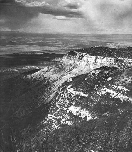
Mesa Verde lies in the extreme northeastern part of the Navajo section of the Colorado Plateau Physiographic Province, although the older work of Fenneman places it in the adjacent Canyon Lands section. The mesa itself is more properly called a cuesta. Its scarplike eroded front rises some 2,000 feet above the Montezuma Valley and the gently southwesterly sloping plain to the north, known as the Dolores Plateau. The great cuesta itself drops off to the south from some 8,600 feet at the northern rim to around 6,000 feet at the Colorado-New Mexico line. The relatively smooth surface of the great mass is dissected by generally north-south-trenching canyons, deep and cliff-sided, which have dissected the cuesta into similarly north-south-running potreros, locally called mesas. These vary from a mile or more to a few tens of yards in width. Their upland surfaces are forested or brushy with some open, grassy areas at the northern, higher parts, and are easily traversed. The surface is generally earthy with minimal stoniness; the percentage of bare ground is small in the higher, northerly parts of Mesa Verde but increases markedly as one goes south, to the Mancos River, as more shale is exposed.
North-south travel is a simple matter, either on the mesa fingers or potreros or along the canyon bottoms. East-west movement is entirely the opposite. The traversing of a single canyon, in the middle to southern parts of the mesa where these are well developed, is an effort. The canyons themselves, in the area of greatest aboriginal and present-day occupation on the mesa, vary upward from 600 feet deep. The sides are vertical with steeply sloped colluvial talus and terraces; it is often difficult to find breaks for descending from the mesa top.
Vegetation is characterized by a sameness throughout undisturbed parts of the mesa. Forest fires have left some scars. These break the monotony; their impact is especially strong on hot, dry days!
A discussion of either soils or vegetation, although pertinent, is not offered here, for neither is well understood now. Their detailed examination forms part of our program. Suffice it to say that the most prominent vegetal cover is the pygmy pinyon-juniper forest. This is weak or nonexistent in the northerly, higher and moist sections of the cuesta, where it either is not fully at home or has been burned off. To the south the forest masks the land so thoroughly that special techniques had to be evolved in order to accomplish the archeological survey of the Wetherill Mesa surface (Hayes and Osborne, 1961). The nonforested northerly sections are primarily brushy: Gambel oak, serviceberry, sage, and fendlera are the major components. Open grassed areas, perhaps over 50 percent of the whole cover, lend a semiparkland effect to the scene. Autumn colors paint this section liberally with reds and yellows, and it is host to numerous deer. Canyon vegetation is generally brushy in the bottoms, mostly sage; the talus slopes are usually forested with juniper-pinyon or the impenetrable oak. Soils are red, moderately heavy desert soils and lithosols. Local areas of gray and fairly humus-rich soils appear. The role played by red loess, probably from the southwestward, has not been pinned down; presumably it was a large one.
Climatically our region is semiarid; rainfall has averaged nearly 19 inches a year over a period of 40 years. A program of environmental measurements, now in operation and centered chiefly around temperature and rainfall variation in the different altitudes and geomorphic variants of the mesa, will enable us later to offer details concerning the present climate and to discuss the importance of these factors to the aboriginal occupants. We can say, now, that Mesa Verde and adjacent regions to the northwest were especially favored by precipitation and by deep deposits of the red loess. These advantages promoted use of this land by agricultural Indians.
THE GEOLOGY
It is the Mesozoic (Cretaceous) and Cenozoic eras that have contributed primarily to the visible landscape in the area of our interest. A description of the geology of earlier times is far less pertinent; indeed, it is not well known and need not be dealt with at length here. Although Precambrian structures and rocks no doubt provide a basement for the superficial and to us more important formations, they are exposed in few places in the Colorado Plateau and are lacking completely in the Mesa Verde area. The older deposits appear to have been originally laid down in troughs of unknown size and trend. They have been metamorphosed anciently and thoroughly and injected by igneous material of a now similar nature so that all semblances, other than chemical, to the parent materials have been lost. Such Precambrian formations as do show are, then, schists, quartzites, gneisses, amphibolites, granites and granodiorites, gabbros and andesites. They represent a history of geologic and early life processes as long as all later time but the script is difficult indeed to read.
The lower Paleozoic, Cambrian through Devonian, was a time of stability. Mountains of the upper Precambrian, within the east-central part of the Colorado Plateau or nearby, were reduced, resulting in a peneplain surface of low altitude. Most of the plateau was essentially a shelf area without geosynclinal development. By a contrast, rocks of great thickness were deposited to the west (in the now Basin and Range Province), and rocks of lesser thickness were laid down in central Colorado to the northeast. Troughs or synclines thus surrounded the plateau in these directions, as is generally true of the province through Permian (middle through upper Paleozoic) time except that the Paradox Basin, or Valley, developed as a deep trough in the Pennsylvanian. This was part of a large system of northwesterly trending down-warps which transgressed the Rocky Mountain System of that same period. Some 7,000 feet of marine deposits were laid down in the Paradox Basin, but later Paleozoic rock formations are generally thin elsewhere in the plateau. Formations of this same time are enormously deep to the west and again less so in the east. Again very long-term stability as a shelf is indicated. This extends generally throughout the Paleozoic with the single exception of the relatively minor Paradox downfold and transgression.
In some ways the Paleozoic stability of the plateau continued almost throughout the Mesozoic. Formations thicken from south to north and northwest and, as usual, become much thicker in the country immediately west of the province. The Triassic and Jurassic red beds and other nonmarine or terrestrial formations appear to terminate with the Morrison (McElmo) of Upper Jurassic. Extensive fossiliferous deposits in these are not characteristic of this area. During the Upper Cretaceous the plateau, again almost as a unit, seems to have gone beneath the sea, with a slight downward tilt to the northwest where deposits thicken. The highlands that furnished the sediments for the late Cretaceous formations, which form the major geologic phenomenon at Mesa Verde, lay west and south of the plateau.
UPPER CRETACEOUS SERIES
Mesa Verde is in reality a small corner or detached islet of an immense south-sloping (from the La Plata Mountains) to roughly level synclinal sheet of Cretaceous sedimentaries, sandstones, and shales that extends far south into northwestern New Mexico. There it expands to cover a sizable part of that quarter of the State. The Mesaverde group (Point Lookout sandstone, Menefee shale, and Cliff House sandstone) thins toward the north and northeast (basinward or seaward) and is younger, more recent, in its northern than in its southern parts. To the south (highland- or mountainward) it is capped by increasingly younger, though still Upper Cretaceous, sediments which were formed first in marine situations (Lewis shale, Pictured Cliffs sandstone), then fluvially (Fruitland formation, Kirtland shale), and then wholly or largely terrestrially (McDermott formation).
The small corner of this great mass which has been called Mesa Verde has been isolated and given its peculiar character by Cenozoic erosion. Montezuma Valley and the Dolores Plateau lie immediately to the north of the mesa, the latter underlain by Dakota sandstone which in turn underlies Mancos shale. The valley is drained to the west by McElmo Creek and is locally as much as 2,000 feet below the high, northern scarp of the mesa. This scarp continues around to the west and towers over the valley there between itself and the Ute Mountain (El Late) to the west.
The mesa is isolated from the remainder of the Upper Cretaceous mass on the south, southeast, and east by the deeply entrenched Mancos River. This old stream has had to lower its base level, keeping pace with the San Juan River, into which it empties. This, in turn, led to the marked downcutting that resulted in the long, fingerlike mesas and deep intervening canyons of the Mesa Verde. This kind of drainage is far more marked in the south-sloping Mesa Verde corner of the Upper Cretaceous sediments than it is elsewhere on them. Some of the canyons have cut their way so far headward (northward) that they have encountered the south-eroding scarp and notched this high northern rim of the mesa.
Thus the Mancos River, following an old and probably antecedent course and cutting off a small islet of south-sloping sediments, which was likewise isolated on the northern and western sides, set the stage for a highly intensified and peculiar form of physiographic development which, after some millions of years, was put to an intensified and unusual use by a group of sedentary Indians.
Alexander Wanek's (1959, pp. 675-76) two introductory paragraphs to his geology section should be quoted rather than paraphrased:
The exposed sedimentary rocks in the area are late [Upper] Cretaceous in age and are about 3,600 feet thick. The rocks consist of sandstone, siltstone shale, and coal that were deposited in marine, brackish, or fresh water. Locally these rocks are intruded by small irregular igneous bodies and by dikes. The stratigraphic sequence is conformable from the Dakota sandstone, the oldest exposed formation, to the Cliff House sandstone, the youngest exposed unit. Locally the Cliff House sandstone is unconformably ovelain by small bodies of cemented gravels. The mesa surface appears to be a part of a late [upper] Tertiary (?) pediment (Atwood and Mather, 1932, p. 91) that rises northeastward toward the La Plata Mountains. The close relationship of the mesa to the La Plata and San Juan Mountains is indicated by the gravel deposits and a scattering of well-worn pebbles which, from their composition, must have been derived from these areas of uplift.
The major structural features of the area resulted from the Laramide orogeny and subsequent folding and tilting movements. Mesa Verde lies in a shallow southward-plunging synclinal fold that is marginal to the northwest part of the San Juan Basin. On the west the beds are inclined away from the bordering Sleeping Ute Mountain uplift; on the east they dip gently from the La Plata Mountains and Barker Dome, and to the north the beds dip away from the Dolores Plateau. The strata flatten in the southern part of the area, but southeast of the area the dips increase sharply along the hogback or structural rim of the basin.
There can be no doubt that there were many strata of a respectable thickness, perhaps over a mile of them, overlying the sediments that remain. These younger rocks, partly Upper Cretaceous but mostly lower Cenozoic, still overlie the Cliff House member in the Durango area east of Mesa Verde.
The Dakota sandstone underlies the area as a whole but is not seen in exposures within the Mesa Verde proper. North and west of it, especially in the McElmo Canyon, which is the type area, it is generally light in color but ranges to rusty-brown or gray. It is quartzose and has local shale lenses and coal seams, the latter in minor commercial quantity. There is great range in the lithological quality of the formation. Its origin is partly marine and partly lagoon or estuarine and beach. It is unconformable upon the Upper Jurassic Morrison and is assignable to both upper Lower and lower Upper Cretaceous.
Mancos shales and the Dakota sandstone on which they lie conformably often intergrade or exhibit transitional zones, where it may be difficult to separate the two satisfactorily. The Mancos shale varies locally from 1,200 to slightly over 2,000 feet thick. It is generally dark greenish-gray to black with extensive calcareous and gypsiferous inclusions. Several limestone and sandstone beds within it are fossiliferous. The shales are highly carbonaceous and unstable; in general they support or underlie talus slopes north of the park. Their origin is marine.
The base of the Mesaverde group intertongues extensively with the upper parts of the Mancos shale. This indicates an unstability of the shoreline and of the depths at which the deposits were being made during the transition from deposition of shale to sandstone. The Mesaverde group is made up of three formations: the lower marine Point Lookout sandstone; the Menefee shales, sandstone and coal measures; and finally the Cliff House sandstone. These all rise stratigraphically to the north and are younger, of more recent deposition, as one moves northward.
Point Lookout sandstone becomes markedly massive as it develops upward from the transitional zone between itself and Mancos shale. Colors range from cream to buff and red-brown; thickness ranges upward to 300 feet. The massive member is actually formed of a series of long overlapping lenses that thin northward. This documents the retreat of the Cretaceous sea in that direction as land to the southwest rose and the detritus from its eroding surfaces poured down to the northeast into the sea and formed the Mesaverde group. Fossils are rare in this formation.
Next, the Menefee formation lies conformably on the Point Lookout. It is a gray clay and carbonaceous shale with sandstone and coal measures. Like the other formation, it thins to the northeast. Thickness in our area varies over 300 feet; the commercial coal comes primarily from a bed in the lower third of the formation. The coal beds of the upper parts of the formation have been burned in a number of places along the Mancos River. Here the adajcent shales have been clinkered and the red and red-brown colors are striking. Fine pieces of this burned shale were valued as a material for personal ornaments by the ancient inhabitants. The formation is primarily nonmarine but has a few beds. It underlies most of the talus slopes within the park.
Cliff House sandstone is the uppermost member of the Mesaverde group and the ground surfaces of most of the mesa today. Its total thickness varies from 90 to 400 feet now but at one time was much greater. It is essentially a light to red-brown sandstone with some inclusions of sandy shale. The beds are massive locally. The interfingering of the shaly members and the sandstone suggests an oscillating shoreline which controlled the depositions of this predominantly marine formation. It is divisible into several units, which are fossiliferous in some places. These units also react differently to erosion and form benches and the alcoves or overhangs, locally called caves, which shelter the famed cliff dwellings.
An impervious shaby layer, about midway in Cliff House sandstone, not only has led to the development of the local cliff profile and of most of the caves but is the prime control over the development of springs and seeps. It is a geologic arrangement that has brought caves and ruins and water into proximity.
The extensive interfingering of the lower Cliff House with the Menefee bespeaks a southward transgression of the ocean and a rapid rise in the rate of erosion of the southern highlands.
A great loss of depth of Upper Cretaceous strata, due to later erosion, has been noted. This plus the southward tilt and the deposition of gravels are all general aspects of geologic processes which took place during the Tertiary. We shall trace the broader aspects of change for the region of our particular interest.
During the Upper Cretaceous, then, the plateau was a basin into which sediments from the south were carried. Our area was near the edge of shallow seas and was low-lying land at this time. With the onset of the Cenozoic era the conditions were reversed, and uplift, igneous activity, and degradation began. In the Paleocene the Four Corners and Mesa Verde area lay south of the developing San Juan upwarping, which had started in Upper Cretaceous. Drainage from this highland led south and east, and presumably both removed Cretaceous sedimentaries and deposited volcanic detritus in the Mesa Verde area.
In Eocene time a downwarping of the north-central parts of the plateau established a huge basin, and eventually the great Green River Lake in Utah filled it. This led a large part of the drainage from the ancient San Juans to the west and probably initiated the present pattern although interior drainage then characterized the plateau. Obigocene and early Miocene times were not drastic in their changes. River courses and patterns of erosion changed, no doubt, as the center of the interior drainage in southern or south-central Utah shifted, but the broad outlines of westward drainage and local Four Corners' erosion continued.
Miocene time was one of volcanism, igneous intrusion, and upwarping throughout the plateau. The Ute Mountain appeared by middle Miocene and the La Plata-San Juan-San Miguel Mountains complex was well along in its development. The Mesa Verde area and its over all drainage pattern must have been evolving too. It probably alternated between periods of intense down-cutting and of extensive deposition from the La Platas. During the upper Miocene to middle Pliocene the whole plateau rose and was tilted to the northeast. Volcanic activity was renewed and several small stocks were intruded into the Cretaceous sandstones during the Pliocene. Probably much of the downcutting in the mesa area occurred during this period of uplift. The Mancos formed its impressive canyon, and the headward cutting of the tributary canyons to the north gave the mesa its basic mesa and canyon pattern. No major changes appear to have taken place in the drainage pattern since then. Gravel deposits still remain in the southern parts of Mesa Verde from the middle Tertiary cycles of erosion. Pleistocene glaciation carved out the present character of the neighboring mountains. Some uplift occurred then and a cycle of canyon cutting impressed the present topography on the land. Erosion and canyon cutting are still proceeding, especially by the larger streams.
Pre-Wisconsin soils, apparently widespread in the west, occur in the Mesa Verde area. They stem from a moister time than present and indicate various modes of formation. Those in the mesa appear to have formed partly in situ and to have been masked later by a rich red loess, an excellent agricultural soil. Colluvial talus slopes, common in the area, have been little studied.
|
| North Scarp of Mesa Verde. |
| <<< Previous | <<< Contents>>> | Next >>> |
archeology/7a/prologue2.htm
Last Updated: 16-Jan-2007