|
Curecanti National Recreation Area Colorado |
|
 NPS photo | |
Curecanti National Recreation Area's stark landscape bears the imprint of attempts to alter these rugged mesas and canyons for human purposes. The most recent major alteration was the construction of three dams on the Gunnison River to provide irrigation and hydroelectric power. These Wayne N. Aspinall Unit dams of the Bureau of Reclamation's Upper Colorado River Storage Project have transformed this semiarid locale into a water-based recreation mecca.
The high, dry, eroded vistas are now interrupted not only by the Gunnison River's narrow thread, but also by three reservoirs: Blue Mesa, Morrow Point, and Crystal. Blue Mesa serves as the main storage reservoir. Morrow Point Dam generates most of the power, and Crystal Dam maintains an even flow through the Black Canyon of the Gunnison.
The old rock faces of the Black Canyon that hold the water of the Morrow Point and Crystal reservoirs tell of changes that have occurred over two billion years. Surrounding mesas are capped with cliffs and rocky spires telling of violent volcanic eruptions some 30 million years ago. These formed the West Elk Mountains to the north. Later episodes to the south, forming southwestern Colorado's scenic San Juan Mountains, spewed vast quantities of ash over this area. The ancestral Gunnison River readily cut down through this volcanic matter, but below lay the tough, ancient rock that is exposed in Black Canyon. This canyon lends the fjordlike character to Morrow Point and Crystal reservoirs' steep, rock walls. Blue Mesa's bed formed in less-resistant volcanic mudflow materials. As these eroded beneath solidified volcanic layers, spires formed.
You can see a fine example of this formation when hiking the Dillon Pinnacles Trail. The most striking feature of the lower reservoirs is the spirelike Curecanti Needle. It is best viewed from the tour boat on Morrow Point Reservoir. Curecanti's fish—brook, brown, rainbow, and Mackinaw trout and kokanee salmon—attract the greatest number of people to the park. Recreational opportunities abound for power boating, sailing, windsurfing, camping, hiking, and hunting. Any season offers such rewarding sightseeing as the Morrow Point Dam, Pioneer Point, and the Cimarron Railroad Exhibit's historic narrow gauge. But for the most part, you have the rare opportunity to savor here the solitude and silence of the canyons and mesas.
History
Few clues remain of the Ute Indians who lived here when pioneers and settlers arrived in the 1800s. Human occupation dates back to at least 10,000 years ago. Archeologists have uncovered the remains of ancient structures called wickiups that date back 4,500 years. These are some of the oldest dwellings to have been uncovered here. Utes of historic times spent summers in the mountains and winters near today's Montrose and Grand Junction. Like many of the area's earlier inhabitants, they were attracted here by the abundance of game in the dry hills and river valleys and by the vegetation in the canyons and on the mesas.
Fur traders and miners blazed the northern branch of the Spanish Trail from Santa Fe to Los Angeles. This trail first linked Ute country to Anglo and Spanish commerce. Despite negative reports by Capt. John Gunnison and his Pacific Railroad party, who surveyed the area in 1853, a narrow-gauge railroad transported ore, coal, cattle, and other goods in this area by 1882. The Denver & Rio Grande Railroad, bearing the Curecanti Needle on its logo, spurred development of small towns like Cimarron. The railroad operated from 1882 to 1949.
The region's farmers and ranchers soon coveted the Gunnison River's waters for their crops and livestock. The six-mile Gunnison Tunnel was cut through a mesa to deliver the water to the Uncompahgre Valley for agricultural uses. The tunnel was opened in 1909. Today it is recognized as a National Civil Engineering Landmark.
Fishing
Brown, rainbow, Mackinaw, and brook trout and kokanee salmon attract fishing enthusiasts to park waters in summer and winter. The three dams of the Wayne N. Aspinall Unit dramatically changed the area's fishery. Where once the rainbow and brown trout of the Gunnison River fed mainly on aquatic insects, some fish of Curecanti's reservoirs feed on plankton. Plankton are microscopic plants and animals that flourish in this new reservoir environment. Brook trout favor the reservoir's tributary streams. The reservoirs' concentration of plankton is suitable for maintaining kokanee. Kokanee lure many people to the area, particularly during the snagging season, which generally begins in November. Kokanee salmon are the most commonly caught fish. In Blue Mesa Reservoir's deep subsurface canyons lurk cold-water-loving Mackinaw (lake) trout caught at over 30 pounds here. Rainbows, introduced in the Gunnison River in the 1880s, are still stocked, along with kokanee salmon.
Fishing Regulations
A Colorado fishing license is required for persons age 16 and older. Buy
licenses at marinas or at a number of area sporting goods stores. • Know
the regulations. Before going fishing, check for closures, seasons, bait, and
any other local restrictions that may apply. • Use the fish cleaning
stations provided. If one is not available, use trash cans for proper
disposal.
Fishing Tips
The best fishing times are early morning and late evening, when the fish are
feeding. Flies work best in evenings.
Troll at 5 mph for rainbow trout, slower for kokanee. Kokanee travel in schools. If you get a strike but do not pull in a fish, it may mean that you are trolling too fast for this tender-mouth salmon. Troll deeper for cold-water loving Mackinaws. In summer, run leaded lines 40-70 feet deep.
Shore fishing is best when reservoir levels are low, in late spring and early summer. As the level rises and the water warms, the fish are found deeper and in the middle.
Snagging for kokanees begins in November. For the exact date, contact the park.
Winter
Winter finds elk, bighorn sheep, and deer coming down from the mountains to feed and to avoid the harsher conditions found at higher elevations. Despite the beautiful snow-capped mesas, clear blue skies, and abundant wildlife, winter here is harsh. Temperatures dip as low as -40°F and are made even more dangerous by strong winds. Adequate Winter preparation for winter activities is a must.
Ice fishing is popular in winter. Four inches of hard clear ice are needed to support one adult afoot. Get specific rules that pertain to ice fishing from visitor centers or from park rangers before you venture onto the ice.
Cross-country skiing is a good way to see wildlife wintering near Blue Mesa, or try the beginners' ski trail near the Elk Creek Visitor Center, conditions permitting. Advanced ski routes follow U.S. Forest Service access roads leading from the park.
Warning: Strong winds make wind chill factors extreme. Be prepared. Here are some general principles to follow: Wear clothing in several light layers. Hooded and windproof outer layers are important. Keep your head and neck covered and warm. • Hands and feet are the most difficult to keep warm. Mittens are better than gloves. • Boots should be big enough to allow good circulation. Contact the park or ask rangers for winter safety and preparedness information.
Orientation
Elk Creek Visitor Center is open year-round. Exhibits tell about Curecanti's natural and cultural histories and introduce its recreational activities. Schedules of park programs are available at visitor centers and campgrounds.
Information is also available at Lake Fork and Cimarron visitor centers.
Activities, Programs, and Services
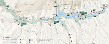 (click for larger map) |
Sightseeing
Scenic Colo. 92 skirts Black Canyon's north rim for spectacular views. The
Pioneer Point overlook offers views into this deep canyon and a chance to learn
its history.
East Portal Road provides access to the Gunnison Tunnel and Gunnison River. Vehicles longer than 22 feet, including trailer, are prohibited.
See the historic train exhibit at Cimarron. Rangers at the visitor centers can answer questions and help you plan your visit.
Services
Marinas are located at Elk Creek and Lake Fork. Each has a small grocery store,
boat rentals, guide service, slips, and showers. There is a restaurant at Elk
Creek. Find full travel services in Gunnison, 16 miles east of Elk Creek, and in
Montrose, 20 miles west of the Cimarron entrance.
Hiking and Trails
Curecanti's trail system offers varied hiking experiences. Trails may have rapid
vertical elevation changes. Some trails are ideal for short backpacking trips or
long day hikes. Birders especially enjoy the Neversink Trail with its
lush streamside habitat that birds favor. The Dilion Pinnacles Trail
threads dry mesa country to the spectacular Dillon Pinnacles and on for an
impressive view of Blue Mesa Reservoir. Curecanti Creek and Hermits Rest
trails—both strenuous—lead to Morrow Point Reservoir from Colo.
92.
Crystal Creek Trail, moderately strenuous, leads to an overlook of Crystal Reservoir, the canyon, and surrounding San Juan and West Elk mountains. Mesa Creek Trail follows Crystal Reservoir's shore as a fishing access trail. Pine Creek Trail leads down to Morrow Point Reservoir for the boat tour, shore fishing, launching of hand-carried craft, or sightseeing along a limited section of the historic narrow-gauge railroad bed.
Caution—hikers please note: Curecanti lies 7,500 feet above sea level. Easy trails may be strenuous if you are not used to the altitude.
Camping
Major developed campgrounds are Elk Creek, Lake Fork, Stevens Creek, and
Cimarron. Smaller areas at Dry Gulch, Red Creek, Ponderosa, Gateview, and East
Portal offer more seclusion. Camping is allowed in designated areas only.
Reservations are available at Elk Creek, Lake Fork, Stevens Creek, and East Elk
Creek and Red Creek group sites: www.reserveusa.com. All other campsites are first-come,
first-served. Each reservoir offers water-access campsites for boaters.
Picnicking
The picnic areas have toilets but no running water, except at Elk Creek
(year-round) and Iola (May to September). There are also picnic tables along
U.S. 50 and Colo. 92.
Swimming
Swimming is prohibited from docks and launch ramps. There are no specially
designated swimming areas within the recreation area. Water temperatures are
very low, shorelines can be precipitous, and submerged rocks are hazardous.
If you swim, use extreme caution. Don't linger in cold water, because of the dangers of hypothermia. Extended exposure to these cold waters can lower your body temperature to dangerous. even fatal, levels. Ask a ranger about the early symptoms of hypothermia so that you can heed them.
Accessibility
Visitor centers. East Portal ranger station, and most campgrounds are wheelchair
accessible for visitors with disabilities; Lake Fork is most suitable. Ask for
details.
Hunting
Both Colorado and federal hunting laws apply within the park. Discharging
firearms in developed or populous areas is prohibited. Carrying or possessing a
loaded weapon in a motor vehicle, vessel, or other mode of transportation is
prohibited. Hunters on horseback may use the corrals at Ponderosa and Dry
Gulch.
Boating and Water Safety
Blue Mesa Reservoir is 20 miles long. Its three basins, Iola, Cebolla, and Sapinero, are suitable for boating. There are launch ramps at Elk Creek, Lake Fork, Iola, and Stevens Creek. Sail boarding and waterskiing are popular on Blue Mesa Reservoir in the summer.
Federal boating safety regulations apply. Coast Guard-approved personal flotation devices (PFDs) must be carried for each person aboard. Your boat must be registered in your home state. All motorized and/or state-registered vessels on Blue Mesa Reservoir are required to have a boat permit.
Because Morrow Point and Crystal reservoirs lie deep in the canyon, boating use is limited to hand-carried craft. The Pine Creek Trail, off U.S. 50, leads down 234 steps to Morrow Point Reservoir. Take the Mesa Creek Trail near Cimarron down to Crystal Reservoir. Fluctuating water levels and releases from Blue Mesa and Morrow Point Dams cause boating hazards. Check on hazards and launch conditions with the rangers at any visitor center.
Your safety equipment must include these items: personal flotation device (PFD) for each passenger, type 4 throwable flotation device for boats 16 feet or greater, fire extinguisher, lights for dusk-to-dawn operation, sound-producing device, working ventilation device for inboard engines. Consult the Colorado Boating Statutes and Regulations.
Be alert to strong afternoon winds—they arise suddenly. It is best to travel west in the morning and east in the afternoon. Keep protective coves in sight. When the winds do pick up, head for shore. Strong changeable currents are an additional concern on Morrow Point and Crystal reservoirs.
Aids to Navigation
Rangers patrol to help boaters in distress and to check for safety equipment; requirements are posted at launch areas. Know the rules of the road and navigational aids. • If your boat capsizes, stay with it until help arrives. • Keep a safe distance from spillways, divers, and smaller craft. • A third person must be on board as observer when towing skiers. Don't tow skiers within 500 feet of beaches or mooring areas or within 100 feet of swimmers.
All crafts must observe wakeless areas in the West Elk, Lake Fork, and Cebolla Creek arms and east of the Lake City Bridge.
Reservoir Surface Elevations
Elevations of the reservoirs vary year-round. Contact the park for information.
Full pool elevations (above sea level) are:
Blue Mesa Reservoir 7,519 feet
Morrow Point Reservoir 6,760 feet
Crystal Reservoir 6,755 feet
Source: NPS Brochure (2020)
|
Establishment Curecanti National Recreation Area — February 6, 1965 |
For More Information Please Visit The  OFFICIAL NPS WEBSITE |
Documents
1979 Investigations at Seven Archeological Sites in Curecanti National Recreation Area (Mark A. Stiger, 1981)
A Survey of Vegetation in the Curecanti Reservoir Basins University of Utah Anthropological Papers No. 56/Upper Colorado Series No. 6 (Angus M. Woodbury, Stephen D Durrant and Seville Flowers, June 1962)
Annotated Checklist of Vascular Flora, Curecanti National Recreation Area NPS Natural Resource Technical Report NPS/NCPN/NRTR-2009-232 (Tim Hogan, Nan Lederer and Walter Fertig, July 2009)
Archeological Survey of Black Canyon of the Gunnison National Monument and Archeological Inventory and Evaluation of Curecanti Recreation Area Midwest Archeological Center Occasional Studies in Anthropology No. 7 (Mark A. Stiger and Scott L. Carpenter [Black Canyon] and Mark A. Stiger [Curecanti], 1980)
Curecanti: Great Scenery, Outstanding Resources, and Good Neighbors (June 2, 2004)
Ecological Studies of the Flora and Fauna of the Curecanti Reservoir Basins, Wester Colorado University of Utah Anthropological Papers No. 59/Upper Colorado Series No. 8 (Angus M. Woodbury, Seville Flowers, Heber H. Hall, Robert N. Reynolds, R. Bruce Walker, Calvin R. Lamborn, Allen W. Knight, Delbert W. Argyle, J.W. Richardson, Jr., A. Dean Stock, George F. Edmunds, Ronald W. Olson, Stephen Durrant and Elroy B. Robinson, November 1962)
Fire Management Plan Environmental Assessment, Black Canyon of the Gunnison National Park and Curecanti National Recreation Area (October 2024)
Formation Processes in Curecanti Archeology: The Elk Creek Site Midwest Archeological Center Technical Report No. 45 (Janis L. Dial, 1996)
Foundation Document, Curecanti National Recreation Area, Colorado (December 2013)
Foundation Document Overview, Curecanti National Recreation Area, Colorado (January 2013)
General Management Plan: Black Canyon of the Gunnison National Monument and Curecanti National Recreation Area (September 1997)
Geologic Map of the Black Ridge Quadrangle, Delta and Montrose Counties, Colorado (Wallace R. Hansen, 1968)
Geologic Map of the Black Canyon of the Gunnison River and Vicinity, Western Colorado (Wallace R. Hansen, 1971)
Geologic Resource Evaluation Report, Black Canyon of the Gunnison National Park & Curecanti National Recreation Area NPS Natural Resource Report NPS/NRPC/GRD/NRR-2005/001 (T.L. Thornberry-Ehrlich, January 2005)
Historic Background Study: Curecanti Recreation Area, Colorado (Benjamin Levy, October 15, 1968)
Innovative strategies to develop interpretive media for paleontological sites at Curecanti National Recreation Area, Colorado (Alison L. Koch and Philip J. Zichterman, New Mexico Museum of Natural History & Science Bulletin 34, 2006, ©New Mexico Museum of Natural History and Science, all rights reserved)
Landscape Phenology, Vegetation Condition, and Relations with Climate at Curecanti National Recreation Area, 2000-2019 NPS Science Report NPS/SR-2025/219 (David Thoma, January 2025)
Limnology of Blue Mesa, Morrow Point, and Crystal Reservoirs, Curecanti National Recreation Area, during 1999, and a 25-Year Retrospective of Nutrient Conditions in Blue Mesa Reservoir, Colorado U.S. Geological Survey Water-Resources Investigations Report 02-4199 (Nancy J. Bauch and Matt Malick,, 2003)
National Register of Historic Places Nomination Forms
Curecanti Archeological District (Bruce Jones and Adrienne Anderson, Winters 1981-1982/1983-1984)
Denver & Rio Grande Narrow Gauge Trestle (Karl T. Gilbert, January 10, 1975)
Denver & Rio Grande Railroad Box Outfit Car No. 04414 (Jacqui Ainlay-Conley and Frank Carl Barna, July 7, 2008)
Denver &Rio Grande Western Railroad Boxcar No. 3132 (Lance C. Westfall and Carl Barna, August 5, 2008)
Denver & Rio Grande Western Railroad Caboose No. 0577 (Lance Westfall and Frank Carl Barna, August 5, 2008)
Denver & Rio Grande Western Railroad Locomotive No. 278 and Tender (Lance C. Westfall and Frank Carl Barna, August 5, 2008)
Paleontological Discoveries at= Curecanti National Recreation Area and Black Canyon of the Gunnison National Park, Upper Jurassic Morrison Formation, Colorado (Alison L. Koch, Forest Frost and Kelli C. Trujillo, New Mexico Museum of Natural History & Science Bulletin 36, 2006, ©New Mexico Museum of Natural History and Science, all rights reserved)
Park Newspaper (Visitor Guide/The Portal): 2003 • 2006 • 2007 • 2008 • 2009 • 2011 • 2012 • 2020
Recreation Potential: The Curecanti Unit of the Colorado River Storage Project (July 1965)
Resource Protection Study
Final Resource Protection Study / Environmental Impact Statement, Curecanti National Recreation Area, Colorado (August 2008)
Final Resource Protection Study / Environmental Impact Statement: Summary, Curecanti National Recreation Area, Colorado (August 2008)
Newsletter #1: Spring 2001 • Newsletter #2: Winter 2002 • Newsletter #3: Fall 2003
Report to Congress (June 2009)
Summary: Final Resource Protection Study/Environmental Impact Statement, Curecanti National Recreational Area (August 2008)
State of the Park Report, Curecanti National Recreation Area, Colorado State of the Park Series No. 13 (2014)
Statement for Management — Curecanti National Recreation Area (November 1990)
The Curecanti Archeological Project: The Archeology of Marion, an Historic Railroad Camp in Curecanti National Recreation Area, Colorado Midwest Archeological Center Occasional Studies Series No. 9 (Mary P. Rossillon, 1984)
The Curecanti Archeological Project: The Late Prehistoric Component at Pioneer Point Midwest Archeological Center Occasional Studies Series No. 24 (Janis L. Dial, 1989) (Note: Restricted access, not for public viewing)
Toolbox of Incentives for Resource Conservation: A Handbook of Ideas for Neighbors in the Curecanti Area (May 23, 2003)
Vascular Plant Species Discoveries in the Northern Colorado Plateau Network: Update for 2008-2011 NPS Natural Resource Technical Report NPS/NCPN/NRTR-2012/582 (Walter Fertig, Sarah Topp, Mary Moran, Terri Hildebrand, Jeff Ott and Derrick Zobell, May 2012)
Vegetation and Soil Trends, Black Canyon of the Gunnison National Park and Curecanti National Recreation Area, 2011-2012 NPS Science Report NPS/SR-2025/254 (Carolyn Livensperger, March 2025)
Water Quality Data Analysis and Interpretation, Curecanti National Recreation Area NPS Technical Report NPS/NRWRD/NRTR-95/68 (Barry A. Long, Lynn S. Cudlip and Rebecca A. Smith, December 1995)
cure/index.htm
Last Updated: 19-Mar-2025