|
Fire Island National Seashore New York |
|
 NPS photo | |
Life on a Barrier Island
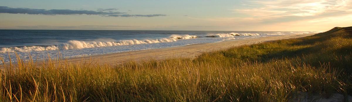
From the air Fire Island is fragile and isolated. Atlantic waves beat against a white beach; gnarled trees embrace barely visible homes; then it's gone, and Great South Bay dominates the image. Over the centuries devastating storms off the Atlantic Ocean have battered dunes, opened inlets, and threatened to destroy Fire Island. Yet this barrier island is resilient; beaches eroded by winter storms are replenished by the return of sand from off-shore sandbars, and beach grasses establish a foothold once again on slowly developing primary dunes. Wildlife abounds on the island. Deer roam freely and find shelter in thickets; toads, cranberries, and cattails live in freshwater areas between ocean and bay; and migrating ducks and geese seek refuge in marshes. For visitors and residents of the diverse communities, this island so near urban New York is a place of excitement and solitude. Fire Island National Seashore was established in 1964 to preserve the only developed barrier island in the United States without roads. In 1980 Congress designated 1,400 acres including a 7-mile stretch of island as a national wilderness area.
Fire Island—the genesis of its name sparks our imagination. The island may have been named after Fire Island Inlet, which appeared on a deed in 1789, and the inlet's name may have started as a simple spelling error. The number of inlet islands has varied over time, and it is likely that "five" or the Dutch word "vier," meaning four, was misspelled on early maps as "fire." Fire Island Beach appeared on charts in the 1850s, and folklore suggests the name arose from land-based pirates, or "wreckers," who built beach fires at night to lure cargo ships onto shore. Some say poison ivy gave Fire Island its name, either for its red leaves in autumn or its fiery itch. The origin of its name may be obscure, but Fire Island's role in maritime history is well known. The island's wealth of seafood, waterfowl, and plants attracted American Indians and, later, European settlers. The Fire Island Lighthouse guided ships safely past sandbars. Surfmen of the U.S. Lifesaving Service, housed in stations along the beach, rescued shipwreck survivors.
Formed long ago by currents carrying eroded glacial debris, Fire Island continues to change through the action of wind and waves. Most dramatic are the hurricanes and the nor'easters that demolish the dunes and wash away homes. Undaunted by nature's occasional wild spirit, visitors and residents find the island a welcome respite from urban pressures.
Relaxation is paramount here, and the national seashore has much to offer. The 7-mile area west of Smith Point is a wilderness environment that shelters endangered and threatened species. Protected here are piping plover, which lay their eggs on the high beach in hollows lined with small rocks and shells. Hunted until 1918 for their feathers, they are now endangered by seaside development, predators, and recreational activities. At Watch Hill you can experience the sounds and smells of a salt marsh, where fish, shellfish, insects, and birds flourish among salt-tolerant grasses. Here you can see herons, egrets, and other wildlife and learn about salt marsh and tidal ecosystems.
A special treat is a visit to Sailors Haven and the Sunken Forest, where 200-year-old holly trees, sassafras trees with mitten-shaped leaves and other hardwoods shadow you with their canopy. Salt air and driving winds prune trees in the Sunken Forest to the height of the primary dune. Not to be missed are the communities where you can enjoy the lively nightlife and traverse miles of boardwalks past secluded homes. On the western end of the national seashore, visit the Fire Island Lighthouse and the museum housed in the keeper's quarters to learn about Fire Island's lifesaving efforts and maritime traditions.
Ocean and Beach
Fire Island is on the move. Every day more than 10,000 waves pound its beach, shoveling sand into currents that carry 500,000 cubic yards westward each year. The bulk is transported in winter and during storms, but an equivalent daily rate would find about 25,000 persons hauling little red-wagon loads of sand to Democrat Point. A witness to this migration is the Fire Island Lighthouse. Built in 1858 at the island's western end, it is now nearly 5 miles east of Democrat Point. Plants and wildlife move with the island, but humans who have built homes and summer memories are not finding it easy to let nature take its course.
Dunes and Forest
Dunes are formed when ocean winds carry sand inland until an obstacle such as beach grass interrupts the wind's velocity, and the sand is dropped. The grasses respond by spreading their roots and sending up shoots. Birds and animals attracted by the grasses deposit new seeds, and a variety of vegetation begins. Behind these growing barricades, shrubs take hold and build soil. They are replaced by thickets and eventually holly and hardwood forests. So the cycle continues. Without the anchoring roots of beach grasses there would be no dunes; without sheltering dunes there would be no forests; and without this precious balance, there would be no island.
Marshes and Bay
Along with its western migration caused by long-shore currents, Fire Island is slowly moving north toward Long Island. In a sense the island is rolling over on itself as sand from the oceanside is gathered by wind and waves, blown or washed across the island or moved by currents and tides through inlets, and deposited on the bayside. Marsh grasses colonize the deposits and produce organic debris that combines with the sand. The resulting marshes and their nutrient-rich muck are among the most productive areas on Earth.
Exploring Fire Island
Enjoying Your Visit
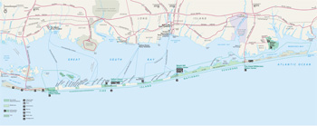 (click for larger map) |
Ferries run May through October. • Bay Shore to Kismet, Saltaire, Fair Harbor, Dunewood, Atlantique, Ocean Beach, Seaview, and Ocean Bay Park. • Sayville to Sailors Haven, Cherry Grove, and Fire Island Pines. • Patchogue to Davis Park and Watch Hill.
Railroad stations are near 3 ferry terminals. When on Fire Island water taxis can shuttle you from point to point. Vehicle access and parking are limited to Smith Point County Park and Robert Moses State Park; fees are charged. You may walk from the parking lots to the Fire Island Lighthouse and Fire Island Wilderness visitor centers. There are no public roads. Most boardwalk trails, some camping, and parking are accessible for disabled persons. Off-season services are limited.
Fire Island Lighthouse Walk to the visitor center and maritime museum for interpretive programs, tower tours by reservation, and exhibits.
Sailors Haven Area has 42-slip marina, electricity, coin pumpout, visitor center, maritime forest exhibits, Sunken Forest self-guiding trail, pay phone, food, picnic tables, and bathhouse.
Watch Hill Area has 188-slip marina, coin pumpout, 50-amp electricity, visitor center, salt marsh and tidal estuary programs, self-guiding nature walks, limited canoe trips, family and group camping by reservation, a pay phone, food, picnic tables, and bathhouse.
Fire Island Wilderness Area offers visitor center (seasonal), exhibits on the wilderness and its biodiversity, self-guiding trails, and hunting and off-road vehicle permits (seasonal). No parking.
William Floyd Estate This Mastic Beach, Long Island, home offers tours, exhibits, and self-guiding tours of 12 outbuildings and the cemetery.
Playing it Safe Children on docks should wear lifebelts or jackets. Use sunscreen. Poison ivy flourishes here: its 3-leaflets, vines, and roots can cause allergic reaction. Mosquitos are abundant, and ticks carrying Lyme disease are common; wear insect repellent and inspect yourself carefully. Stay on boardwalks and protect your feet from splinters. Do not feed wildlife. All plants, animals, and natural features are protected by law. Stay off the dunes; their fragile vegetation protects the island. In an emergency, call a ranger, marine police, or 911.
Where is Fire Island?
This thin New York island stretches 32 miles along Long Island's south shore, from Moriches Inlet on the east to Democrat Point on the west. It forms a barrier between Great South Bay and the Atlantic Ocean. It supports a state park, a county park, the national seashore, communities, and a seven-mile stretch that is the only federal wilderness area in New York state.
Source: NPS Brochure (2004)
|
Establishment
Otis Pike Fire Island High Dune Wilderness — December 23, 1980 |
For More Information Please Visit The  OFFICIAL NPS WEBSITE |
Documents
A Field Evaluation of Fire Island National Seashore Estuarine Resources with an Emphasis on Nekton Communities NPS Technical Report NPS/NESO-RNR/NRTR/97-08 (Kenneth B. Raposa and Candace A. Oviatt, August 1997)
A Review of Sediment Budget Estimations at Fire Island National Seashore NPS Technical Report NPS/NER/NRTR-2008/114 (Erika E. Lentz, Cheryl J. Hapke and William C. Schwab, March 2008)
Administrative History of Fire Island National Seashore (Betty Thompson, June 1977)
Annual Report (Fire Island Soundings): 2003 • Summer 2006
Anthropogenic influences on the dune/beach morphology of a moderately developed barrier island: Fire Island, New York NPS Technical Report NPS/NER/NRTR-2008/131 (Meredith G. Kratzmann and Cheryl J. Hapke, October 2008)
Assessment of Alternatives: William Floyd Estate, Fire Island National Seashore, New York (May 1978)
Assessment of Natural Resource Conditions: Fire Island National Seashore NPS Natural Resource Report NPS/NRPC/NRR-2009/139 (Anne McElroy, Mark Benotti, Gregory Edinger, Aissa Feldmann, Christine O'Connell, Gillian Stewart, R. Lawrence Swanson and John Waldman, August 2009)
Assessing the Response of Juvenile and Adult Hard Clams to the New Breach in Great South Bay: Post-Hurricane Sandy study NPS Natural Resource Report NPS/NCBN/NRR-2017/1505 (Christopher J. Gobler and Alexandra Stevens, September 2017)
Atlantic National Seashores in Peril: The Threats of Climate Disruption (Stephen Saunders, Tom Easley, Dan Findlay and Kathryn Durdy, ©The Rocky Mountain Climate Organization and Natural Resources Defense Council, August 2012, all rights reserved)
Bay Shoreline Physical Processes, Fire Island Fire Island National Seashore Science Synthesis Paper, NPS Technical Report NPS/NER/NRTR-2005/020 (Karl F. Nordstrom and Nancy L. Jackson, September 2005)
Coastal Hazards & Sea-Level Rise Asset Vulnerability Assessment for Fire Island National Seashore NPS 615/154058 (B. Tormey, K. Peek, H. Thompson, R. Young, S. Norton, J. McNamee and R. Scavo, April 2018)
Coastal Vulnerability Assessment of Fire Island National Seashore to Sea-Level Rise USGS Open-File Report 2003-439 (Elizabeth A. Pendleton, S. Jeffress Williams and E. Robert Thieler, 2004)
Conceptual Master Plan for Fire Island National Seashore, Suffolk County, New York (February 28, 1973)
Conservation and Management of the Living Marine Resources of Fire Island National Seashore Fire Island National Seashore Science Synthesis Paper, NPS Technical Report NPS/NER/NRTR-2005/023 (David O. Conover, Robert Cerrato and William Wise, December 2005)
Cultural Landscape History for Fire Island National Seashore (Marstel-Day, Kristie Baynard, Kara Saffos and Paula Bienenfeld, 2022)
Cultural Landscape Report for the William Floyd Estate, Fire Island National Seashore, Mastic, Long Island, New York (John W. Hammond, 2021)
Cultural Landscapes Inventory: Fire Island Light Station, Fire Island National Seashore (1998)
Cultural Landscapes Inventory: William Floyd Estate, Fire Island National Seashore (1998)
Deer, People and Parks: Perspectives of Residents in Communities Near Fire Island National Seashore HDRU Series Publication 07-8 (William F. Siemer, Kirsten M. Leong, Daniel J. Decker and Karlene K. Smith, December 2007)
Density and Herd Composition of White-tailed Deer Populations on Fire Island National Seashore NPS Technical Report NPS/NESO-RNR/NRTR/98-4 (H. Brian Underwood, Fred D. Verret and James P. Fischer, June 1998)
Development of the Geomorphological Map for Fire Island National Seashore: Principal Characteristics and Components NPS Natural Resource Report NPS/NRSS/GRD/NRR-2015/941 (Norbert P. Psuty, Monica Patel, Joelle Freeman, William Schmelz, William Robertson and Andrea Spahn, March 2015)
Development of the Geomorphological Map for William Floyd Estate — A Unit of the Fire Island National Seashore: Principal Characteristics and Components NPS Natural Resource Report NPS/NRSS/GRD/NRR-2018/1593 (Norbert P. Psuty, William Schmelz and Andrea Spahn, February 2018)
Discovering Fire Island: The Young Naturalist's Guide to the World of the Barrier Beach (Bill Perry, 1978)
Distribution and dispersal of mosquitoes, Fire Island National Seashore, New York (Howard Ginsberg and F. James Rohlf, undated)
Ecological Studies of the Sunken Forest, Fire Island National Seashore, New York (HTML edition) Scientific Monograph No. 7 (Henry Warren Art, 1976)
Ecology and Management of Ticks and Lyme Disease at Fire Island National Seashore and Selected Eastern National Parks NPS Scientific Monograph NPS/NRSUNJ/NRSM-92/20 (Howard S. Ginsberg, 1992)
Estuarine Resources of the Fire Island National Seashore and Vicinity A Final Report (Henry Bokuniewicz, Anne McElroy, Cornelia Schlenk and Jay Tanski, eds., December 1993)
Ethnographic Overview and Assessment, Fire Island National Seashore Final Report (Setha M. Low and Dana H. Taplin, July 2006)
Evaluating VDataum in Coastal Network Parks: Fire Island National Seashore, Gateway National Recreation Area, and Assateague Island National Seashore NPS Natural Resource Report NPS/NCBN/NRR-2016/1148 (David Ullman, Amanda Babson and Michael Bradley, March 2016)
Evaluation of Marsh Development Processes at Fire Island National Seashore: Recent and Historic Perspectives NPS Technical Report NPS/NER/NRTR-2007/089 (C. T. Roman, J.W. King, D. R. Cahoon, J.C. Lynch and P.G. Appleby, July 2007)
Final Fire Island Wilderness Breach Management Plan/Environmental Impact Statement, Fire Island National Seashore (December 2017)
Final Report of the NPS Vegetation Mapping Project at Fire Island National Seashore (Scott D. Klopfer, Adele Olivero, Lesley Sneddon and Julie Lundgren, April 2002)
Final White-tailed Deer Management Plan and Environmental Impact Statement, Fire Island National Seashore (December 2015)
Fire Island Lighthouse: Electric Station Proposal (Fire Island Lighthouse Preservation Society, 2005)
Fire Island Lighthouse: First Order Fresnel Lens Return Proposal (Fire Island Lighthouse Preservation Society, 2005)
Fire Island Lighthouse: Power House and Electric Station Floor Plans and Drawings (Fire Island Lighthouse Preservation Society, 2005)
Fire Island Lighthouse: Return of the Fire Island Lighthouse First Order Fresnel Lens (Fire Island Lighthouse Preservation Society, 2005)
Foundation Document, Fire Island National Seashore, New York (November 2018)
Foundation Document Overview, Fire Island National Seashore, New York (November 2018)
General Management Plan, Fire Island National Seashore (September 1977)
Geomorphology of the South Shore of Long Island, New York Beach Erosion Board Technical Memorandum No. 128 (Norman E. Taney, September 1961)
Hibernal Phenology of the Eastern Box Turtle, Terrapene carolina carolina, William Floyd Estate, Fire Island National Seashore NPS Natural Resource Report NPS/NCBN/NRR-2018/1595 (Margarete A. Walden and Nancy E. Karraker, February 2018)
Historic Furnishings Report: William Floyd Estate, Volume 1: Historical Data, Fire Island National Seashore, Mastic, NY (Janice Hodson, December 2011)
Historic Resource Study, Fire Island National Seashore, Long Island, N.Y. (Laraine Fletcher and Ellen Kintz, 1979)
Historic Resource Study: The William Floyd Estate, Fire Island National Seashore (Ricardo Torres-Reyes, June 1974)
Historic Resource Study: William Floyd Estate, Fire Island National Seashore (Jennifer L. Anderson, May 2021)
Historic Structure Report: Fire Island Lighthouse and Keeper's Dwelling — Volume 1 (Carole L. Perrault, written 1993, published 2004)
Historic Structure Report: Fire Island Lighthouse and Keeper's Dwelling — Volume 2 (Carole L. Perrault, written 1993, published 2004)
Historic Structure Report: Fire Island Lighthouse and Keeper's Dwelling — Volume 3 (Carole L. Perrault, written 1993, published 2004)
Historical and Recent Shoreline Changes, Impacts of Moriches Inlet, and Relevance to Island Breaching at Fire Island National Seashore, NY (James R. Allen, Charles L. LaBash and Peter V. August, and Norbert P. Psuty, April 2002)
Human Interaction with the Coastal Geomorphology of Fire Island NPS Technical Report NPS/NER/NRTR-2008/132 (Norbert P. Psuty and Tanya M. Silveira, September 2008)
Identifying Capacity for Local Community Participation in Wildlife Management Planning; Case 1: White-tailed Deer Issues at Fire Island National Seashore HDRU Series Publication 07-1 (Kirsten M. Leong and Daniel J. Decker, Human Dimensions Research Unit, Department of Natural Resources, Cornell University, February 2007)
Integrated Coastal Climate Change Vulnerability Assessment: Fire Island National Seashore NPS Natural Resource Report NPS/FIIS/NRR-2020/2156 (Glenn Ricci, Donald D. Robadue, Jr., Pam Rubinoff, Alanna Casey and Amanda L. Babson, July 2020)
General Management Plan, Fire Island National Seashore (September 1977)
Inventory of Amphibians and Reptiles at Fire Island National Seashore NPS Natural Resource Report NPS/NCBN/NRTR-2010/378 (Robert P. Cook, David K. Brotherton and John L. Behler, September 2010)
Inventory of Amphibians and Reptiles at the William Floyd Estate, Fire Island National Seashore NPS Natural Resource Report NPS/NCBN/NRTR-2010/380 (Robert P. Cook, David K. Brotherton and John L. Behler, September 2010)
Inventory of Odonata (Dragonflies and Damselflies) at Fire Island National Seashore NPS Natural Resource Technical Report NPS/NCBN/NRTR-2010/295 (Nina Briggs, Eric G. Schneider, Jackie Sones and Kristen Puryear, March 2010)
Junior Ranger Activity Booklet, Fire Island National Seashore (Date Unknown; for reference purposes only)
Land Regulation at Fire Island National Seashore: A History and Analysis, 1964-2004 (Special History Study) (Ned Kaufman and Charles Starks, September 2008)
Legislative History of Fire Island National Seashore (2000)
Legislative History of Fire Island National Seashore 1964-1980 (June 2010)
Legislative History of Fire Island National Seashore 1984-1986 (June 2010)
Long Island's Dynamic South Shore: A Primer on the Forces and Trends Shaping Our Coast (J. Tanski, New York Sea Grant, November 2007 )
Monitoring Salt Marsh Vegetation and Nekton at Fire Island National Seashore and the William Floyd Estate: 2015 Summary Report NPS Natural Resource Data Series NPS/NCBN/NRDS-2015/995 (Erika L. Nicosia, December 2015)
Mosquito Action Plan (MAP), Fire Island National Seashore (2007)
National Register of Historic Places Nomination Forms
Fire Island Light Station (Steven Kesselman, April 17, 1981)
William Floyd Estate (Old Mastic House) (Anne Booth, July 1977)
Northeast Coastal and Barrier Network Geomorphological Monitoring Protocol: Part I—Ocean Shoreline Position, Version 2 NPS Natural Resource Report NPS/NCBN/NRR-2022/2415 (Norbert P. Psuty, Mark Duffy, Dennis E. Skidds, Tanya M. Silveira, Andrea Habeck, Katherine Ames and Glenn Liu, June 2022)
Numerical Modeling of Fire Island Storm Breach Impacts Upon Circulation and Water Quality of Great South Bay, NY NPS Technical Report NPS/BSO-RNR/NRTR/00-10 (Daniel C. Conley, March 2000)
Off-Road Vehicle Regulations (36 CFR 7.20) (1987)
Overview of Climate Change Adaptation Needs, Opportunities and Issues: Northeast Region Coastal National Parks NPS Natural Resource Report NPS/NER/NRR-2014/789 (Amanda L. Babson, April 2014)
Piping Plover Habitat Suitability on Central Long Island, New York Barrier Islands NPS Technical Report NPS/NAROSS/NRTR/95-29 (Susan P. Elias-Gerken, James D. Fraser and P.A. Buckley, January 1995)
Population regulation, natural enemies, and host-seeking patterns of deer ticks, Ixodes scapularis (Acari: Ixodidae) Final Report NPS Technical Report NPS/NESO-RNR/NRTR/96-02 (Howard S. Ginsberg and Roger A. LeBrun, January 1996)
Preservation of Historic Resources on Barrier Islands (W.P. Gregg, Jr., 1978)
Program Schedule (Summer BUZZ): 2007 • 2008 • 20039 • 2010 • 2011 • 2012 • 2013 • 20015
Proposed Fire Island National Seashore, Suffolk County, New York (September 1963)
Recommendations for a Barrier Island Breach Management Plan for Fire Island National Seashore, including the Otis Pike High Dune Wilderness Area, Long Island, New York NPS Technical Report NPS/NER/NRTR-2007/075 (S. J. Williams and M. K. Foley, February 2007)
Room Guides for Interpretation: William Floyd Estate (Steven Kesselman, June 1982, revised June 1983)
Shoreline Change Along Fire Island National Seashore: Annual Monitoring Report, 2007-2008 (Revised) NPS Natural Resource Data Series NPS/NCBN/NRDS-2013/450 (Norbert P. Psuty, Tanya M. Silveira, Aaron Love and William Hudacek, March 2013)
Shoreline Change Monitoring at Fire Island National Seashore: 2010-2011 Annual Report NPS Natural Resource Technical Report NPS/NCBN/NRTR-2011/512 (Norbert P. Psuty, William Hudacek and Aaron Love, December 2011)
Shoreline Position Monitoring at Fire Island National Seashore: 2017-2022 and 2007-2022 Trend Report NPS Natural Resource Report NPS/NCBN/NRR-2023/2531 (Norbert P. Psuty, Christopher Menke, Andrea Habeck and Jordan Raphael, June 2023)
Supplementary Report on Proposed Fire Island National Seashore, Suffolk County, New York (September 1963)
The Coastal Geomorphology of Fire Island: A Portrait of Continuity and Change Fire Island National Seashore Science Synthesis Paper, NPS Technical Report NPS/NER/NRTR-2005/021 (Norbert P. Psuty, Michele Grace and Jeffrey P. Pace, September 2005)
The Impacts of Hurricane Gloria Deer & Trails The Sunken Forest, Fire Island National Seashore, Fire Island, New York NPS Technical Report NPS/NAROSS/NRTR-87/01 (Henry W. Art, July 1992)
The Role of Disturbance in the Long-Term Viability of a Coastal Maritime Forest Fragment NPS Technical Report NPS/NER/NRTR 2008 104 (Jodi A. Forrester, Donald J. Leopold and H. Brian Underwood, January 2008)
The Story of...the Fire Island Light (Henry R. Bang, 1981)
Vector-borne Diseases on Fire Island, New York Fire Island National Seashore Science Synthesis Paper, NPS Technical Report NPS/NER/NRTR-2005/018 (Howard S. Ginsberg, September 2005)
Water Quality and Ecology of Great South Bay Fire Island National Seashore Science Synthesis Paper, NPS Technical Report NPS/NER/NRTR-2005/019 (Kenneth R. Hinga, September 2005)
White-tailed Deer Ecology and Management on Fire Island Fire Island National Seashore Science Synthesis Paper, NPS Technical Report NPS/NER/NRTR-2005/022 (H. Brian Underwood, September 2005)
Wildland Fire Management Plan, Fire Island National Seashore (February 2005)
Wilderness Management Plan, Fire Island National Seashore (November 1983)
William Floyd Estate, Assessment of Alternatives, Fire Island National Seashore (May 1978)
fiis/index.htm
Last Updated: 17-Jan-2025