|
Rock Creek Park District of Columbia |
|
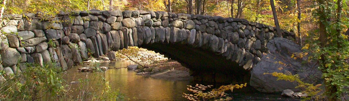 NPS photo | |
At Rock Creek Park you can relax and enjoy many activities. Some require permits or reservations, so please read the following information carefully to see what may be required for your activity.
Picnicking Rock Creek Park has 29 picnic areas, some with rain shelters. Some picnic areas may be reserved for groups up to 75. Other picnic areas are first-come, first-served areas limited to 12 people. Reservations must be made in person at the D.C. Department of Recreation.
Playgrounds The large recreation field at 16th and Kennedy streets, NW, has room for many activities. Some of the fields, which are suitable for soccer, football, volleyball, and field hockey, may be reserved; call the D.C. Department of Recreation.
Tennis The 15 soft-surface and 10 hard-surface tennis courts at 16th and Kennedy streets, NW, must be reserved in person through Guest Services, Inc. The courts are open April through mid-November. A fee is charged. For the rest of the year, the 10 hard-surface courts are available free on a first-come, first-served basis. Four soft-surface courts are off Park Road, just east of Peirce Mill. Make reservations for them through Washington Area Tennis and Education Foundation in person at the courts; open May through September (fee charged). The two courts at Montrose Park are free. When others are waiting, limit your play to one hour.
Trails An extensive system of trails and paths covers Rock Creek Park and outlying areas like Glover-Archbold Park. For the hiker, trails maintained by the Potomac Appalachian Trail Club (PATC) consist of a blue-blazed trail that follows the east side of the creek, a green-blazed trail that follows the western ridge of the park, and tan-blazed connector trails. For physical fitness enthusiasts, a 1.5-mile exercise course begins near Calvert Street and Connecticut Avenue. For the horse rider, 13 miles of wide, dirt and gravel bridle trails crisscross the northern section of the park. An Equitation Field is near picnic area 25. Horseback riding lessons and guided trail rides are available at the Rock Creek Park Horse Center.
Biking A signed bicycle route goes from the Lincoln Memorial through the park and into Maryland. Memorial Bridge connects it to the Mount Vernon Trail in Virginia. Beach Drive between Military and Broad Branch roads is closed to automotive vehicles from 7 a.m. Saturday to 7 p.m. Sunday, and on holidays. Bicycles may be ridden only on paved roads and trails. They are not allowed on unpaved foot or horse trails.
From Maryland to Military Road
Fort DeRussy, one of a ring of Civil War forts to protect Washington, D.C, is off the bike path at Oregon Avenue and Military Road.
Rock Creek Park Nature Center and Planetarium has information and activities related to the park's natural and cultural history. Exhibits present park wildlife and plant life. Programs interpreting the park's natural and cultural history are offered frequently. Contact the park for details. Two self-guiding nature trails start from the nature center. The Edge of the Woods Trail is accessible to wheelchairs and to blind or visually impaired persons. The nature center and all programs are accessible to wheelchairs. The planetarium features astronomy programs about the sky over Washington. The nature center encourages teachers and youth group leaders to use its facilities and staff during the week. Advance group reservations are required. Visit www.nps.gov/rocr for a list of activities. The nature center is open 9 a.m. to 5 p.m. Wednesday through Sunday, It is closed on all federal holidays.
Rock Creek Golf Course, an 18-hole public course with clubhouse, can be reached from 16th and Rittenhouse streets, NW. Clubs and carts can be rented. The clubhouse has lockers and a snack bar. Open daily, except December 25, dawn to dusk. A fee is charged.
Rock Creek Park Horse Center rents horses for guided trail rides and lessons. A therapeutic riding program for persons with disabilities is available. Fees are charged.
Fort Stevens, at 13th and Quackenbos streets, NW, was the site of the only Confederate attack on Washington, D.C, during the Civil War.
Battleground Cemetery, the nation's second smallest national cemetery, is at 6625 Georgia Avenue, NW. Interred there are 41 soldiers killed defending the city at Fort Stevens.
From Military Road to Tilden Street
Fort Reno, one of the ring of Civil War forts, was originally Fort Pennsylvania. Few traces remain of its site, west of Rock Creek Park at Belt Road and Chesapeake Street. From the heights of Tenleytown, the District of Columbia's highest point, it commanded three of the city's major roads: Wisconsin Avenue and River and Reno roads.
Fort Bayard was one of the 68 forts encircling Washington, D.C, during the Civil War. The site on River Road at Western Avenue, NW, offers picnicking and a ballfield.
Carter Barron Amphitheatre, a 3,700-seat outdoor theater in the woods, is home to the performing arts in summer. Information and tickets are available at its box office at 16th Street and Colorado Avenue, NW. Newspaper announcements also give performance times and ticket information.
Park Police Rock Creek Station offers maps and visitor assistance. Accessible for persons with disabilities, it is on Beach Drive south of the Military Road overpass.
Battery Kemble was named after Gouverneur Kemble, a former president of West Point Foundry in Cold Spring, N.Y., one of the nation's earliest foundries to cast good quality cannons. Today's Battery Kemble Park is bounded by Chain Bridge Road, MacArthur Boulevard, 49th Street, and Nebraska Avenue. Activities range from picnicking and games in summer to cross-country skiing and sledding in winter. In summer there is limited parking on site. In winter parking is permitted only on nearby streets.
From Tilden Street to the National Zoo
Park Headquarters houses the superintendent's office, which gives information and permits for special events. You cannot get picnic permits here—request them in person from the D.C. Department of Recreation. If you see a tree across a trail or something that needs attention, call the maintenance yard. Headquarters is open Monday through Friday 7:45 a.m. to 4:15 p.m., and the maintenance yard is open 6:30 a.m. to 3:00 p.m.
Peirce Mill is the last of many mills serving local farmers from the late 18th to early 20th centuries. It is not wheelchair-accessible. All mill tours start at Peirce Barn, across the street. Many tours and programs begin at Peirce Barn, a visitor contact station, with exhibits on the Mills of the Rock Creek valley and information on the Peirce family and estate. Peirce Mill and Peirce Barn hours vary, and group tours may be arranged on request. Visit www.nps.gov/rocrfor information.
National Zoological Park—the Zoo—run by the Smithsonian Institution, features natural environments for many of its 2,000 animals. Enter from Connecticut Avenue or Beach Drive (parking fees charged). It is open daily except December 25.
From the National Zoo to Memorial Bridge
Thompson Boat Center rents bicycles, kayaks, canoes, small sailboats, and rowing shells. Lessons are available. Weather permitting, it is open daily, (except December and January). The entrance is opposite Rock Creek and Potomac Parkway at Virginia Avenue. A few metered parking spaces are available.
Georgetown Waterfront Park is a grassy open space next to the Potomac River. Parking is available on K Street under the Whitehurst Freeway. The park closes at dark.
Glover-Archbold Park includes 183 forested acres from near the corner of Van Ness Street and Wisconsin Avenue south to the C&O Canal. A 3.1-mile trail traverses its length. Whitehaven and Dumbarton Oaks parks connect Glover-Archbold and Rock Creek parks.
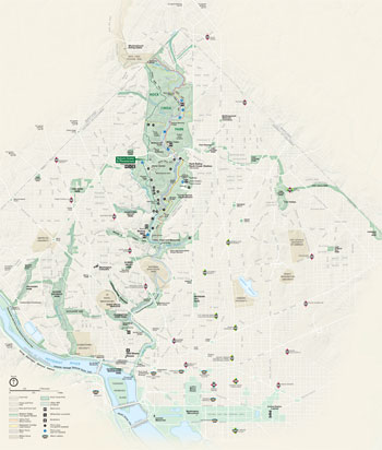 (click for larger map) |
Montrose Park and Dumbarton Oaks Park are on the northern edge of Georgetown, next to Dumbarton Oaks estate. Montrose Park has two tennis courts (first-come, first-served) and picnic and open areas. Dumbarton Oaks Park contains the wildflower gardens and paths of the original Dumbarton Oaks estate. The parks are open daily.
Old Stone House at 3051 M Street, NW, predates the Revolutionary War. Programs tell about its occupants and life in the house and Georgetown from colonial days to today. The hours vary: contact www.nps.gov/rocr.
Regulations
For your safety and to protect the park, please observe these regulations: • The park is open only in daylight hours; traffic is permitted 24 hours a day. Trucks and buses are prohibited on park roads. • Overnight camping is not allowed. • Pets must be leashed at all times. • Use trash cans provided in picnic areas and help keep the park clean. • Fires are permitted only in grills or fireplaces in designated picnic areas; bring your own grill and fuel • All natural and cultural objects are protected by law. Do not collect or disturb rocks, animals, or plants. Let wildflowers grow. Do not remove trees, even dead ones, for firewood. • Hike only on marked trails to minimize erosion. • Bicycles are permitted only on paved bike trails and roads. • Park only in designated areas.
Emergency call park police or 911
Trails
Here are the main park trails; many more side trails connect with the main ones, so you can plan a circular route. The park has two self-guiding interpretive trails; check at the nature center for information. For your safety, use only designated trails. Hikers may use any trail. Bicyclists are limited to paved bicycle routes. Horses must stay on equestrian trails.
| Name | Length/Route | Description |
Valley (Hiking) |
9.0 km/5.6 mi Maryland line to Bluff Bridge |
Moderate Near stream; Blue Blazed |
Western Ridge (Hiking) |
7.4 km/4.6 mi Maryland line to Bluff Bridge |
Moderate Green Blazed |
Bike Trail |
15.8 km/9.8 mi Maryland line to Memorial Bridge |
Easy southern part Moderate northern Both sections paved |
Glover-Arch (Hiking) |
5.0 km/3.1 mi Van Ness St. to C&O Canal |
Easy Yellow Blazed |
Black Horse (Equestrian) |
7.6 km/4.7 mi Maryland line to Broad Branch Rd. |
Moderate |
White Horse (Equestrian) |
8.7 km/5.4 mi Maryland line to Broad Branch Rd. |
Moderate |
Source: NPS Brochure (2005)
El Parque Rock Creek (Rock Creek Park) es un lugar en donde se puede relajar y también disfrutar de muchas actividades. Se requieren permisos o reservaciones para algunas actividades. EI saber adonde ir y a quien ver puede hacer más provechosa su visita por lo que debe leer cuidadosamente la siguiente información y ver así si algo de lo que usted quiere hacer requiere permisos o reservaciones.
Picnic El Parque Rock Creek (Rock Creek Park) tiene 30 áreas de picnic a lo largo del parque; hay amparo contra la lluvia en algunas de ellas. En muchas de estas áreas se pueden hacer reservaciones para grupos de hasta 100 personas. Las reservaciones se tienen que hacer en persona. Para más información llame al Departamento de Recreación (Department of Recreation) del Distrito de Columbia (D.C.). El mapa del parque muestra las áreas que se pueden reservar.
Campo de juegos El gran campo de recreación localizado en las calles 16 y Kennedy Noroeste (16th and Kennedy Sts., NW) tiene capacidad para muchas actividades. Se pueden reservar algunos de los campos que son adecuados para el fútbol, fútbol americano, voleibol y hockey; para reservaciones llame al Departamento de Recreación del D.C. (D C Department of Recreation).
Tenis Los 15 campos de tenis de superficie de barro y los 10 de superfrcie de hormigón de las calles 16 y Kennedy (16th and Kennedy Streets) NW (noroeste) tienen que ser reservados en persona a través de los servicios de invitados (Guest Services lnc.). Los campos están abiertos desde abril hasta mediados de noviembre. Se cobran cuotas de ingreso. Los 10 campos de superficie de hormigón están disponibles y gratis durante el resto del año y se atiende por orden de llegada. Seis campos de superficie de barro están localizados fuera de Calle Park (Park Road) al este de Molino de Peirce (Peirce Mill). Haga reservaciones en persona allí para estos campos a través de Washington Area Tennis Patrons (Usuarios de Tenis del Área de Washington); están abiertos desde mayo hasta septiembre. Se cobra una cuota de ingreso. Los campos en Parque Montrose (Montrose Park) son gratis. Limite su juego a una hora cuando otros esperan.
Senderos Un sistema amplio de senderos y sendas cubre al Parque Rock Creek (Rock Creek Park) y otras áreas de las afueras tales como el Parque de Glover Archbold (Glover Archbold Park). Los senderos para los excursionistas son cuidados por el Club del Sendero Potomac Apalache (Potomac Appalachian Trail Club) (PATC) y consisten de un sendero pintado de azul que corre por el lado este del riachuelo, un sendero pintado de verde que corre por la cresta occidental del parque y un sendero pintado de color café que sirve para conectar los senderos. Para los entusiastas de la cultura fisica hay una pista de ejercicios de una milla y media (1,5) que empieza cerca de la Calle Calvert (Calvert Street) y la Avenida Connecticut (Connecticut Avenue). Hay para los jinetes a caballo 13 millas de anchos senderos de tierra y grava que atraviesan la parte norte del parque. Cerca del área de picnic # 25 (Picnic Grove # 25) hay un campo de equitación. Hay también lecciones de equitación y excursiones guiadas a caballo disponibles en el Centro de Equitación (Horse Center) del Parque Rock Creek (Rock Creek Park).
Bicicletas Una ruta señalada para bicicletas va desde el Monumento Conmemorativo a Lincoln (Lincoln Memorial) a través del parque y adentro de Maryland. El Puente Memorial (Memorial Bridge) lo conecta al Sendero de Mount Vernon (Mount Vernon Trail) en Virginia. La Calle Beach (Beach Drive) entre los caminos Military y Broad Branch (Military and Broad Branch roads) está cerrada a los coches desde las 7 a.m. del sábado hasta las 7 p.m. del domingo y en los días feriados. No se permite montar bicicletas en los senderos de caballos ni en los de peatones
Desde Maryland hasta el Camino Military (Military Road)
Fuerte DeRussy (Fort DeRussy) está en un circulo de fuertes que fueron construidos para proteger Washington D.C. durante la Guerra Civil; el fuerte está fuera del sendero de bicicletas en Avenida Oregón (Oregon Avenue) y Camino Military (Military Road).
El Centro de la Naturaleza y el Planetario Rock Creek (Rock Creek Nature Center and Planetarium) tiene información y actividades relacionadas con la historia natural y cultural del parque. Las exhibiciones tratan sobre la flora y la fauna del parque así como también sobre sus bosques. La biblioteca del parque tiene libros sobre la historia natural y está abierta para todos. Todos los días hay excursiones guiadas por la naturaleza y hay también otros programas educacionales sobre el medio ambiente. Hay dos senderos autoguiados de ida y vuelta por la naturaleza. Tanto el Centro de la Naturaleza (Nature Center) como sus programas son accesibles para las personas en sillas de ruedas. El planetario ofrece programas de astronomia sobre el cielo de Washington. El Centro de la Naturaleza (Nature Center) estimula a los maestros y guías de grupos de jóvenes a usar sus servicios y su personal durante la semana. Para los grupos, hay que hacer las reservaciones con antelación. Hay un calendario disponible cada mes. El Centro de la Naturaleza (Nature Center) está abierto de miércoles a domingo de 9 a.m. a 5 p.m. Está cerrado el 4 de julio, el Día de Acción de Gracias (Thanksgiving—cuarto jueves de noviembre), 25 de diciembre y el 1° de enero.
El Campo de Golf Rock Creek (Rock Creek Golf Course) es un campo público con 18 hoyos con casa club. Se puede llegar al lugar de las calles 16 y Rittenhouse Noroeste (16th and Rittenhouse Sts., NW. Se pueden alquilar los palos y los carros de golf. La casa club tiene armarios y cafeteria. Está abierto diariamente con excepción del 25 de diciembre desde el amanecer al anochecer. Se cobran cuotas de ingreso.
El Centro de Equitación del Parque Rock Creek (Rcck Creek Park Horse Center) alquila caballos para las excursiones guiadas por los senderos y también para las lecciones de equitaci6n. Hay un programa terapéutico para personas con discapacidad. Se cobran cuotas de ingreso.
Desde el Camino Military (Military Road) hasta la Calle Tilden (Tilden Street)
Fuerte Stevens (Fort Stevens) fue el lugar donde ocurrió el único ataque de los confederados contra Washington D.C. durante la Guerra Civil; está localizado en las calles 16 y Quackenbos Noroeste (161h & Quackenbos Sts. NW).
Fuerte Reno (Fort Reno) fue antes conocido como Fuerte Pennsylvania (Fort Pennsylvania) dentro del circulo de fuertes de la Guerra Civil. El sitio del fuerte, del cual no queda rastros, está en las alturas de Tenleytown al oeste del Parque Rock Creek (Rock Creek Park) en el lugar más alto del Distrito de Columbia (District of Columbia). El fuerte domina tres caminos principales: Avenida Wisconsin (Wrsconsin Avenue), Camino River (River Road) y Camino Reno (Reno Road). El sitio está en Camino Belt (Belt Road) y Calle Chesapeake (Chesapeake Street).
Fuerte Bayard (Fort Bayard) fue uno de los 68 fuertes que rodeaban a Washington D.C. durante la Guerra Civil. El sitio está en el Camino River (River Road) en Avenida Western, Noroeste (Western Ave, NW) Hay actividades que incluyen picnic y campo de béisbol.
Anfiteatro Carter Barron (Carter Barron Amphitheatre) es un teatro de 4000 asientos al aire libre en el bosque; funciona como el lugar principal de las artes de la representación del verano. La información y los boletos están disponibles en la taquilla que está en las calles 16 y Kennedy Noroeste (16th and Kennedy Sts. NW). Los anuncios de los periódicos informan también sobre los horarios de las presentaciones artisticas y sobre cómo obtener los boletos. Hay estacionamiento disponible durante las representaciones artfsticas; durante la semana el estacionamiento está disponible para los viajeros diarios al trabajos.
El Centro de Información y Subestación de la Policía del Parque (Park Police Substation and Information Center) proporciona mapas, información y asistencia al visitante y es completamente accesible para personas con discapacidad. Está en Calle Beach (Beach Drive) al sur del paso elevado del Camino Military (Military Road) y está abierto diariamente desde las 7 a.m hasta las 4 p.m.
Battería Kemble (Kemble Battery) fue nombrado por Gouveneur Kemble, un expresidente de la Fundición de West Point en Cold Spring, Nueva York. Las actividades van desde picnic y juegos en el verano hasta viajes en trineos y esquí a campo traviesa en el invierno. Está lindado por el Camino del Puente Chain (Chain Bridge Road), la Bulevar MacArthur (MacArthur Blvd), Calle 49 (49th St.) y por la Avenida Nebraska (Nebraska Ave.). Hay estacionamiento limitado en el sitio durante el verano. En el invierno sólo se permite el estacionamiento en las calles cercanas.
Desde la Calle Tilden (Tilden Street) hasta Zoológico Nacional (National Zoo)
En las Oficinas Administrativas del Parque (Park Headquarters) la oficina del superintendente es la que se encarga de dar información y permisos para eventos especiales. Los permisos para picnic no se pueden conseguir aquí—estos hay que solicitarlos en persona en el Departamento de Recreación (Department of Recreation) del Distrito de Columbia. Si ve un árbol caido sobre un sendero u otra cosa que necesita atención llame al taller de mantenimiento (Maintenance Yard). Las Oficinas Administrativas (Park Headquarters) están abiertas de lunes a viernes de las 7:45 a.m a 4.15 p.m. El taller de mantenimiento (Maintenance Yard) está abierto los mismos días de las 7 a.m. hasta las 3:30 p.m.
Molino de Peirce (Peirce Mill) es el último de los muchos molinos que prestó servicios aquí a los agricultores locales desde los finales del siglo XVIII hasta principios del siglo XX. Se puede visitar el molino concertando una cita previa. Llame a Granero de Peirce (Peirce Barn). No es accesible para personas que usan sillas de ruedas.
Granero de Peirce (Peirce Barn) fue construido entre 1811-1820. Éste servía como almacén para los carruajes, caballos y herramientas de agricultura de la plantación de Peirce. El establo está abierto los sábados y los domingos de 12:00 a 4:00 pm. Está cerrado el 4 de julio. Día de Acción de Gracia, 25 de diciembre y 1° de enero. No es accesible para personas en sillas de ruedas.
El Parque Zoológico Nacional—El Zoológico ("Zoo")—está administrado por la Institución Smithsonian. El Zoológico ofrece ambrentes naturales para muchos de sus 2.000 animales. Entre por la Avenida Connecticut (Connecticut Ave.) o en la Calle Beach (Beach Drive) (se cobra cuota de estacionamiento). Está abierto diariamente con la excepción del 25 de diciembre.
Del Zoológico Nacional (Nationa! Zoo) hasta el Puente Memorial (Memorial Bridge)
En la Caseta de Botes de Thompson (Thompson3 Boat House) usted puede rentar bicicletas, canoas, y botes de remos para explorar el Rio Potomac (Potomac River) y la Isla Theodore Roosevelt (Theodore Roosevelt Island). Está abierta diariamente (con la excepción de diciembre y enero) siempre que haga buen tiempo; la caseta tiene una entrada en la Avenida Virginia (Virginia Ave.) al lado opuesto de Rock Creek y Potomac Parkway. Estacionamiento limitado.
Parque de Glover Archbold (Glover Arehbold Park) es una zona forestal de 183 acres que va desde detrás del restaurante en la esquina de la Calle Van Ness (Van Ness St.) y la Avenida Wisconsin (Wisconsin Ave.) hacia el sur hasta el Canal C & O (C & O Canal) Hay un sendero de 3,1 millas que corre a lo largo del parque. El Parque de Glover Archbold (Glover Archbold Park) está conectado al Parque Rock Creek (Rock Creek Park) a través de Whitehaven Parkway y Parque Dumbarton Oaks (Dumbarton Oaks Park). La información está disponible en el Centro de la Naturaleza (Nature Center).
Parque de Montrose y Parque de Dumbarton Oaks (Montrose Park and Dumbarton Oaks Park) están en el margen norte de Georgetown, al lado de los terrenos de Dumbarton Oaks. El Parque de Montrose (Montrose Park) tiene campos de tenis (se atiende por orden de llegada), áreas de picnic y también áreas al aire libre. El Parque de Dumbarton Oaks (Dumbarton Oaks Park) contiene jardines de flores silvestres y originales de los terrenos de Dumbarton. Contacte al Centro de la Naturaleza (Nature Center) para más información; los parques están abiertos diariamente.
|
(click for larger map) |
La pre-revolucionaria Casa Vieja de Piedra (old Stone House) localizada en 3051 M Street, NW y posee muebles coloniales y ofrece programas sobre la vida colonial. No se permite que entren más de 25 personas al mismo tiempo; los grupos se atienden por citas hechas con antelación. El primer piso y los jardines son accesibles a las personas con sillas de ruedas. La Casa Vieja de Piedra (Old Stone House) está abierta de las 12 p.m. hasta las 5 p.m., de miércoles hasta domingo. Está cerrado los 4 de julio, el Día de Acción de Gracias (Thanksgiving—cuarto jueves de noviembre), el 25 de drcrembre y el 1° de enero.
Reglas
Las siguientes reglas son para su seguridad y para proteger al parque; obsérvelas por favor. • El parque está abierto solamente durante las horas del día; el tráfico vehicular está permitido las 24 horas del día. Los camiones y los autobuses están prohibidos en los caminos del parque. • No está permitido el camping nocturno en el parque. • Siempre mantenga sus mascotas con las correas. • 5e debe usar los cubos de basura que están localizados en las áreas de picnic. También se debe ayudar a mantener el parque limpio. • Los fuegos están permitido solamente en las panillas o en las chimeneas; traiga su propia parrilla y combustible. • Todos los objetos naturales y culturales del parque están protegidos por la ley. No coleccione ni altere las piedras, animales o plantas. Deje que las flores silvestres crezcan. No saque los árboles (ni siquiera los muertos) para usarlos como leña. • Camine solamente por los senderos marcados para así minimizar la erosión. • Las bicicletas solamente pueden transitar en los senderos de bicicletas y en los caminos. • El estacionamiento sólo se permite en las áreas designadas para ello.
Senderos
Aquí están los senderos principales del parque; muchos otros senderos secundarios se conectan con los senderos principales por lo que usted puede planificar una ruta circular. El parque tiene dos senderos autoguiados e interpretativos; obtenga más información en el Centro de la Naturaleza. Para su seguridad use solamente los senderos designados. Los excursionistas pueden usar cualquier sentiero, Los ciclistas están limitados a las rutas pavimentadas para biciletas. Los caballos tienen que pemanecer en 106 senderos ecuestres.
| Nombre | Distancia/Ruta | Descripción |
Valley (excursionismo) |
9.0 km/5.6 mi Desde el linde de Maryland al Puente Bluff. |
Moderado Cerca del riachuelo; pintado de azul |
Western Ridge (excursionismo) |
7.4 km/4.6 mi Desde el linde de Maryland al Puente Bluff. |
Dificil pintado de verde |
Sendero para Bicicletas |
15.8 km/9.8 mi Desde el linde de Maryland al Puente Memorial |
Fácil en la parte sur. Moderado en el norte. Ambas secciones están pavimentadas |
Glover Archbold (excursionismo) |
5.0 km/3.1 mi Desde la Calle Van Ness al Canal C&O. |
EFácil pintado de azul |
Black Horse (ecuestre) |
7.6 km/4.7 mi Desde el linde de Maryland al Camino Broad Branch. |
Moderado siga las señales del caballo negro |
White Horse (ecuestre) |
8.7 km/5.4 mi Desde el linde de Maryland al Camino Broad Branch. |
Moderado siga las señales del caballo blanco |
Source: NPS Brochure (undated)
Peirce Mill
"I was grinding a load of rye for a neighbor when the main shaft of the mill broke," Alcibiades P. White recalled. "I was about half through with the work, and the neighbor had to haul his unground rye away, and I guess he never got it ground. That was the last time the mill operated." That accident in 1897 ended many decades of milling along Rock Creek, for Peirce Mill was the last of eight mills in Rock Creek valley.
Milling in the Rock Creek Valley
By 1897, Peirce Mill had outlived its time. Newer, more efficient mills using steam to power the machinery already could produce fine, white flour faster and less expensively. Today Peirce Mill represents the rural society and economy of America in the 1820s when the transition to power-driven machinery replaced centuries-old methods that relied on sheer muscle power.
The Peirce Family The Peirces traced their origins back to Isaac Peirce, who left his Quaker parents in Pennsylvania, probably in the 1780s, to seek his fortune in Maryland. Peirce worked for Abner Cloud as a millwright, building and repairing mill machinery. In time Peirce married Cloud's daughter; Betsy. In 1794 he bought a 150-acre tract of land that included a mill. By 1800 Peirce's holdings stretched from near the National Zoo north to Chevy Chase. Finally in 1820 he and his stonemason son, Abner, rebuilt the mill using blue granite quarried in the nearby Broad Branch area, giving us today's Peirce Mill. When Isaac Peirce died in 1841 he left the property to his son, who managed it until his death 10 years later. The mill then passed to Abner's nephew, Pierce Shoemaker, who owned it until 1891.
Neither the Peirces nor the Shoemakers were millers (those who operate mills). Isaac was a millwright (one who builds mills), Abner a stonemason, and Pierce Shoemaker a jeweler. A succession of experienced millers ran the mill for them. Despite the Peirces' lack of direct involvement in milling, they were nevertheless interested in the technological changes milling was undergoing.
New Technology For centuries mills had relied on the miller's strength and that of his burly helpers. A major change in the industry occurred in 1795 when a young miller from Delaware, Oliver Evans, wrote a book—The Young Mill-Wright's and Miller's Guide—that revolutionized milling. This book made a science out of what was traditionally a craft. From the time the grain was poured into the receiving bin until dry, clean flour dropped into the holding bins, machinery did all the work. This was Evans's achievement. In 1820, the Peirces rebuilt their mill using the Evans system.
Business was usually brisk at Peirce Mill, especially during the 1860s. Often as many as 12 wagons a day loaded with wheat arrived for grinding. A miller with a helper or two could grind more than 70 bushels a day on each set of buhrs, or millstones.
Today there are three pairs of millstones at Peirce Mill. All the millstones here measure about 4½ feet across and weigh about 2,400 pounds. A miller could not properly operate his mill without the help of the stone dresser, who, with his pick-like millbill, chipped away at the runner and bed stones, sharpening the furrows and shaping the raised areas about every three weeks. Finely ground flour was prized for its baking qualities, so a skilled stone dresser was a valued employee.
Adjusting the distance between the stones was the most critical operation the miller performed. The runner stone, balanced on a spindle, revolved at about 125 revolutions per minute a fraction of an inch above the bed stone. An experienced miller could tell by rubbing some flour between his fingers if the stones were properly positioned and thereby producing the highest grade of flour possible. If adjustments were needed, they could be made easily. Together the miller and stone dresser worked to create a product that satisfied their customers.
How It Works
1 Grain—wheat or corn—goes into the receiving hopper and drops down a chute to the elevator in the basement.
2 The elevator dumps the grain into the rolling screen where a double-mesh screen filters out dirt and any foreign objects. Different grains go into different chutes.
3 At the end of the chute the grain falls into the smutter or fanning mill. This action removes any mold that may have grown on the grain.
4 From the fanning mill the grain falls into storage bins, directly above the millstones.
5 From the bins the grain falls into the hopper that sits directly above a hole in the middle of the millstones. The shoe beneath the hopper regulates the flow of grain onto the bedstone.
6 This is where the major work takes place. The grain falls onto the millstones where it is cut, not ground or crushed, by the rotating stones that move at the rate of 125 revolutions per minute.
7 The grain is now warm and moist flour. It falls through a chute into the basement where elevators pick it up and carry it up to the attic.
8 The hopper boy cools and dries the flour
9 The cooled, dry flour drops into the auger, which moves it, while continuing to dry it, to the head of the bolter.
10 A revolving motion moves the flour over the bolter's screens that vary from fine to medium mesh. Flour falls through the finest mesh. Middlings—bran flakes with some flour particles—pass through the medium screen. And bran, the coarsest, falls out the end.
11 The flour, depending on its fineness, drops into different holding bins and afterwards is loaded into barrels. Sacks did not come into common use until about 1900.
Today at Peirce Mill
In 1890 Congress established Rock Creek Park, and two years later the Federal Government condemned the Peirce Mill property. After the mill ceased functioning in 1897, it served as a public teahouse until the 1930s. In 1934 Secretary of the Interior Harold lckes suggested that Peirce Mill be restored for visitors as part of a general program of depression-era improvements in Rock Creek Park. The waterwheel and interior machinery were rebuilt, and the old millrace was cleaned out and repaired. Two years later the mill resumed operation, but by 1958 the facility was closed. National Park Service planning for the second restoration began in 1967, and Peirce Mill was opened to the public three years later.
Waterpower Rock Creek once supplied the source of energy that turned the waterwheel. Once rotating, the main shaft turned the wooden gears that provided motion. The result was power that did the grinding, lifting, cleaning, drying, and grading of the grain and its flour. About 60 percent of the power was needed to rotate the mill stones; the rest of the power did all the other work. That nearly all of this machinery is wood suggests the ancient origin of milling techniques. This combination of labor-saving methods introduced by Oliver Evans and the use of wooden machinery marks a transitional stage in the milling industry.
Information
Peirce Mill is in Rock Creek Park near the intersection of Beach Drive and Tilden Street. All tours of Peirce Mill begin at Peirce Barn, located across from the mill in the parking lot area on Tilden Street. Peirce Barn has exhibits about mills of the Rock Creek Valley and the Peirce Estate. For visiting times, and for special programs and group reservations, call or visit the park website; www.nps.gov/pimi.
Source: NPS Brochure (2004)
Old Stone House
In the midst of Washington, D.C., a city of grand memorials to national leaders and signifcant events, stands an unassuming building commemorating the daily lives of middle class colonial Americans. Dating from 1765, Old Stone House is the oldest structure on its original foundation in the national capital. Step inside the doors of Old Stone House. Listen and learn its unique stories and discover what they mean to you.
George Washington’s Headquarters?
Since the days when Great Britain ruled the colony of Maryland, Old Stone House has withstood the forces of development and commercial growth that made Georgetown one of the nation's busiest ports by around 1800. Ironically, local folklore is responsible for saving this historical landmark from destruction.
In 1791, when President George Washington and Pierre Charles L'Enfant arrived to carve out the federal district from the surrounding "wilderness", they stayed at the Fountain Inn, operated by John Suter and his family. Commonly called Suter's Tavern, the inn was where the president held negotiations with local landowners. Suter's son, John Suter, Jr., would operate a clock shop in Old Stone House around 1810.
Long after Washington's death, the connection with the Suter family became intertwined with the house's history, and the legend was born that the house served as headquarters for both Washington and L'Enfant. The mythical association of the house with America's first president and the man who helped design the capital saved the house from the fate of other structures of its era. Today, it is believed that Suter's Tavern was located elsewhere in Georgetown, most likely at the corner of what is now 31st and K Streets NW.
Simple and Efficient: Early Days at Old Stone House
Although few detailed records survive from the families who owned the Old Stone House, we can learn much about their lives from the architecture of the house and the personal possessions listed in wills and bills of sales.
In 1764, Christopher and Rachael Layman traveled from Pennsylvania with their two sons to begin a new life in the growing port of Georgetown along the Potomac River. For one pound, ten shillings, they bought Lot Three, a property facing Bridge Street (now named M Street NW).
The Layman's financed the construction of this one-room house and used local blue fieldstone, quarried about two miles upriver, and solid oak boards, hewn with a pit saw. The backbreaking labor and skills of the builders is evident in the well-placed stones and evenly laid ceiling beams. The marks left by the massive saw used to cut the ceiling beams can be seen in the room that housed the Layman family (the bookstore).
The Layman's simple house was functional: stone walls two to three feet thick and packed dirt floors protected the family from harsh weather, while low ceilings conserved heat from the hearth fire.
Outside, house residents planted herbs, vegetables, and fruit trees. A small number of milk cows, hogs, and hens produced the family's meat, milk, cheese, eggs, and butter. A small amount of tobacco was also grown on the property. This labor intensive and land degrading crop was often farmed by African American slaves.
Female Owners and Slave Workers
The Layman's owned the basic essentials: Christopher's tools, a stove, a bible, and some furniture. These items were detailed in Layman's will when he died unexpectedly. In 1767, Rachael Layman remarried and sold Old Stone House to another widow and self-sufficient woman, Mrs. Cassandra Chew.
Mrs. Chew was a member of the upper-middle class. Her wealth included other property in and around Georgetown, as well as slaves. Tax records indicate that Mrs. Chew owned six enslaved African Americans in 1800.
Mrs. Chew's wealth enabled her to make significant additions to the house. She financed construction of the rear kitchen and second and third floors by 1775. Upon her death in 1807, Mrs. Chew bequethed Old Stone House to her oldest daughter, Mary Smith Brumley Like her mother, Mrs. Brumley was financially comfortable. She was the first in a succession of propreiters who leased out the front room (today's bookstore) for business.
An 1826 inventory of her posessions indicates that she owned 15 slaves. One of them, Tabitha, purchased freedom from Mrs. Brumley for herself and her child. Tabitha paid Mrs. Brumley 201 dollars.
By the middle of the 1800s, Georgetown's African American population, both free and slave, made up around one third of the city's total inhabitants. Their labor before emancipation contributed substantially to the commercial development and prosperity of the town.
Recent History of Old Stone House
Old Stone House continued to be privately owned until 1953, when the federal government purchased the property for $90,000 in response to local residents who had come to regard the house as one of historical significance. At that time, the house accomodated offices and the Parkway Motor Company, a used car dealership whose paved lot sat in what is now the location of the English-style garden.
Before the National Park Service (NPS) opened the house to the public in 1960, significant historical preservation work was completed to get the interior of the house looking like it did before 1800. Georgetown residents donated most of the colonial furnishings that can be seen in the house today. John Suter, Jr.'s grandfather clock, which was built in the house over two hundred years ago, was purchased by the NPS and brought back to the house.
Today, Rock Creek Park, a unit of the U.S. National Park System, administers Old Stone House as well as other Georgetown sites including Georgetown Waterfront Park, Dumbarton Oaks Park, Montrose Park, and Francis Scott Key Memorial Park.
We hope that you enjoy your visit to Old Stone House. To learn more, visit www.nps.gov/rocr/ or follow and like us on Facebook at https://www.facebook.com/#!/RockCreekNPS.
Cell Phone Tours
Learn the history of Georgetown's national park sites. Use your cell phone at the following locations and dial (202) 730-9307. Then type in the corresponding number:
9. Dumbarton Oaks Park
10. Montrose Park
11. Francis Scott Key Memorial Park
12. Old Stone House
Source: NPS Brochure (undated)
|
Establishment
Dumbarton Oaks Park — December 2, 1940 |
For More Information Please Visit The  OFFICIAL NPS WEBSITE |
Documents
Acoustic Monitoring Report: Rock Creek Park NPS Natural Resource Report NPS/NRSS/NSNS/NRR-2016/1189 (Scott D. McFarland, March 2016)
Administrative History: Rock Creek Park (HTML edition) (Barry Mackintosh, 1985)
Air & Noise Analysis, Rock Creek Park, Washington, D.C. (Robert Peccia and Associates, Bowlby & Associates, Inc. and University of Central Florida, April 1997)
An Urban Oasis: Rock Creek Park's History and Management (Joan M. Zenzen, October 2020)
Analysis of Vegetation Changes in Rock Creek Park, 1991-2007 NPS Natural Resource Technical Report NPS/NCR/NCRO/NRTR-2009/001 (Jeff S. Hatfield and Cairn C. Krafft, January 2009)
"Bold, Rocky, and Picturesque": Archeological Identification and Evaluation Study of Rock Creek Park: Volume 1 (Louis Berger Group, Inc., August 2008)
Cultural Landscape Report: Meridian Hill Park — Volume 2: Treatment (architrave p.c. architects, November 30, 2001)
Cultural Landscape Report: Peirce Mill Complex, Rock Creek Park (Quinn Evans Architects, August 2009)
Cultural Landscape Report: Rock Creek and Potomac Parkway, Potomac Waterfront Section, National Mall and Memorial Parks (EHT Traceries, Inc. and Stantec, February 2018)
Cultural Landscape Report: The Historic Trails of Rock Creek Park (Deana R. Poss and Frances McMillen, February 2013)
Cultural Landcapes Inventory: Rock Creek Golf Course (2017)
Final White-tailed Deer Management Plan/EIS, Rock Creek Park (December 2011)
Foundation Document, Rock Creek Park, District of Columbia (September 2015)
Foundation Document Overview, Rock Creek Park, District of Columbia (January 2015)
Geologic Resources Inventory Report, Rock Creek Park NPS Natural Resource Report NPS/NRPC/GRD/NRR-2009/146 (T.L. Thornberry-Ehrlich, December 2009)
Historic Furnishings Report: Old Stone House, Rock Creek Park (John P. Brucksch, 1986)
Historic Resource Study: Rock Creek Park (William Bushong, August 1990)
Historic Structures Report: Pierce Mill - Water-Wheel, Rock Creek Park — Part I (Portion) (Blaine E. Cliver, February 1967)
History and construction of the lime-kilns at K Street and Rock Creek Parkway (Henry Alfred Essex, April 13, 1938)
Junior Ranger Activity Book, Rock Creek Park (Date Unknown; for reference purposes only)
Advanced Junior Ranger Book, Rock Creek Park (Date Unknown; for reference purposes only)
Landscape Preservation Maintenance Plan: Dumbarton Oaks Park (Gina Bellavia, Cynthia Cox, Doug Curtis, Lauren Gluschik, Dan Hodgson, Jim Ingram, Jane MacLiesh, Duff McCully, Darwina Neal, Charles Pepper, Brian Stephenson and Steve Strach, April 1997)
Links to the Past: A Historic Resource Study of National Park Service Golf Courses in the District of Columbia (Patricia Kuhn Babin, 2017)
Long-Range Interpretive Plan, Rock Creek Park (March 2010)
Meridian Hill Historic District Design Guidelines (©D.C. Historic Preservation Review Board, 2013)
Meridian Hill Park — African American Experiences Since the Civil War: A Special Study (Elise Elder, September 2019)
Milling in Rock Creek Park: General Background (Charles H. McCormick, November 1, 1967)
National Register of Historic Places Nomination Forms
Boulder Bridge and Ross Drive Bridge (Barry Mackintosh, September 25, 1979)
Conduit Road Schoolhouse (Helen Dillon, November 27, 1972)
Dumbarton Oaks Park (Kay Fanning, September 23, 2003)
Godey Lime Kilns (Helen Dillon, February 27, 1972)
Meridian Hill Park (Ethan Carr, October 13, 1993)
Old Stone House (Helen Dillon, November 27, 1972)
Pierce-Klingle Mansion (Helen Dillon, November 27, 1972)
Peirce Mill (Nancy C. Taylor, February 27, 1969)
Pierce Springhouse and Barn (Helen Dillon, November 27, 1972)
Rock Creek and Potomac Parkway Historic District (Eve L. Barsoum, January 11, 2005)
Rock Creek Park Historic District (William Bushong, January 24, 1990)
Natural Resource Condition Assessment, Rock Creek Park, National Capital Region Network NPS Natural Resource Report NPS/NCRN/NRR-2009/109 (Tim Carruthers, Shawn Carter, Lisa N. Florkowski, Jeff Runde and Bill Dennison, May 2009)
Newsletter (Milling About/TrueGrist, ©Friends of Peirce Mill)
2001: Spring • Summer/Fall
2004: Summer • Fall • Winter/Spring
2005: Summer • Fall/Winter
2006: Summer
2010: Winter
2013: Fall
2014: Summer
2015: Summer
2016: Summer
2017: Summer
2019: Fall
2020: Summer
2021: Summer
2022: Spring
2023: Spring
2024: Summer
Newsletter (Park News and Schedule of Events): Fall 2012 • Winter 2012-2013 • Spring 2013 • Summer 2013
Notes on the establishment of a national park in the District of Columbia and the acquirement and improvement of the valley of Rock Creek for park purposes (William V. Cox, 1901)
Park Newspaper (The Respite):
Peirce Mill preservationists have been active during the "quiet" season (Lee Armfield Cannon, Forest Hills Connection, January 26, 2016)
Photographs, Reduced Copies of Measured Drawings, Written Historical and Descriptive Data, Meridian Hill Park, Sixteenth Street, north of Florida Avenue, N.W, Washington, District of Columbia HABS No. DC-532 (Historic American Buildings Survey, undated)
Preservation of Meridian Hill Park - Phase V and VI: Approval of Final Site Development Plans (National Capital Planning Commission, July 11, 2019)
Rock Creek Park (Olmsted Brothers, December 1918)
Rock Creek Park: A report by the Olmsted Brothers (Olmsted, December 1918)
Rock Creek Park Military Road Trail Feasibility Study: Oregon Avenue / Glover Road NW to 16th Street NW (JMT, May 31, 2022, updated July 29, 2022)
Rock Creek Watershed Conservation Study (CH2M Hill, 1979)
The Effect of Cell Towers on Birds and Bats at Rock Creek Park, Washington, D.C. Final Report (Stephanie D. Dickey and J. Edward Gates, May 18, 2009)
The Loss of the Frances Scott Key House: Was It Really? (Barry Mackintosh, 1981)
The Old Stone House (Cornelius W. Heine, 1955)
The 1918 Olmsted Brothers Report: America's First National Park Master Plan (Timothy Davis, 2022)
Traffic Safety Study, Rock Creek Park, Washington, D.C. (Robert Peccia & Associates, April 1997)
Transportation Study, Rock Creek Park, Washington, D.C. (Robert Peccia & Associates, March 1997)
Rock Creek Sustainability - Tara Morrison, Superintendent, Rock Creek Park
rocr/index.htm
Last Updated: 01-Jan-2025