|
Yellowstone National Park: Its Exploration and Establishment Part II: Definitive Knowledge |

|
|
|
A systematic knowledge of the Yellowstone region resulted from the explorations of the Folson party (1869), the Washburn party (1870), and the Hayden party (1871). Their combined efforts provided a basis for the reservation of the Yellostone wonders in the public interest.
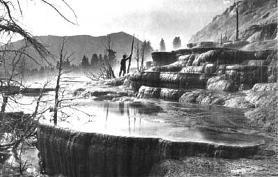
Mammoth Hot Springs, 1871, by
William Henry Jackson.
(U.S. Geological Survey)
The exploring parties of 1869, 1870, and 1871, whose cumulative accomplishment was a definitive knowledge of the Yellowstone region, were a direct outgrowth of an earlier interest in the area's wonders. Thus, it is necessary to go back a few years for the genesis of those efforts through which the true nature of "wonderland" became generally recognized.
An incidental outcome of the visit of Father Francis Xavier Kuppens to the Yellowstone region in the company of Blackfoot Indians in the spring of 1865 (see Part I) was his relation of that experience to a party of gentlemen who were stormbound for several days at the old St. Peter's Mission near the mouth of Sun River the following October. These men, among whom were acting Territorial Governor Thomas Francis Meagher, Territorial Judges H. L. Hosmer and Lyman E. Munson, two deputy U.S. Marshals—X. Beidler and Neil Homie—and a young lawyer named Cornelius Hedges, were traveling from Helena to Fort Benton to assist in negotiating a treaty with the Piegan Indians when overwhelmed by a sudden, savage blizzard and forced to seek shelter at the mission.
Hedges says: ". . . We were received with a warm welcome and all our wants were abundantly supplied and we were in condition to appreciate our royal entertainment." [1] Concerning the story-telling with which the time was passed during that stay at the mission, Father Kuppens adds: [2]
On that occasion I spoke to him [Meagher] about the wonders of the Yellowstone. His interest was greatly aroused by my recital and perhaps even more so, by that of a certain Mr. Viell [3]—an old Canadian married to a Blackfoot squaw—who during a lull in the storm had come over to see the distinguished visitors. When he was questioned about the Yellowstone he described everything in a most graphic manner. None of the visitors had ever heard of the wonderful place. Gen. Meagher said if things were as described the government ought to reserve the territory for a national park. All the visitors agreed that efforts should be made to explore the region and that a report of it should be sent to the government.
As previously mentioned, the Indian unrest occasioned by the opening of the Bozeman Trail route prevented an implementation of Meagher's suggestion during 1866, and, when conditions were at last satisfactory for an expedition into the Yellowstone region—through establishment of Fort Elizabeth Meagher and Camp Ida Thoroughman by the Montana volunteers early in 1867—the tragic death of Acting Governor Meagher cooled the enthusiasm of most of the gentlemen who had made plans to explore the headwaters of the Yellowstone River. While a party did go as far as Mammoth Hot Springs (the Curtis-Dunlevy expedition mentioned in Part I), their visit was essentially a prospecting junket.
No effort was made during 1868 to organize a general exploration of the Yellowstone region, at least so far as the public records show; but there was individual interest in such a project. Of this, Charles W. Cook says:
The first attempt made by me to make an exploration trip to the headwaters of the Yellowstone and Madison rivers was in 1868. At that time I had charge of the "Boulder Ditch Company" at Diamond City. A Mr. Clark, who as I remember, was connected with some mining operations was at Diamond City, and since there was no hotel, was staying at the "Ditch Office." I found he had traveled extensively and had, at times contributed articles to magazines. I told him about the region at the headwaters of the Yellowstone and Madison rivers, which had not been explored, and he became very much interested. We went to Helena to see H. H. McGuire, who published a paper called the Pick and Plow at Bozeman, Montana, but who was at that time visiting Helena. Mr. McGuire advised us that since it was getting late, being then about the middle of September, it was not best to attempt the trip that year. [4]
The following summer, 1869, there was a renewed interest in implementing Meagher's suggestion that the Yellowstone region should be explored. This was publicized in the Helena Herald, in an item announcing:
A letter from Fort Ellis, dated the 19th, says that an expedition is organizing, composed of soldiers and citizens, and will start for the upper waters of the Yellowstone the latter part of August, and will hunt and explore a month or so. Among the places of note which they will visit, are the Falls, Coulter's Hell and Lake, and the Mysterious Mounds. The expedition is regarded as a very important one, and the result of their explorations will be looked forward to with unusual interest. [5]
That notice is undoubtedly the "rumor" which Cook notes as inducing himself and his friend, David E. Folsom, to hold themselves "in readiness to make the trip," to which he adds:
. . . but sometime in the month of August, not having heard from the party, I made a trip to Helena to find out if anyone intended going, and was unable to find anyone who had any intention of making the trip that year. After I returned to Diamond City, David E. Folsom and William Peterson volunteered to make the trip with me. [6]
The manner in which that decision—certainly no trivial one—was arrived at is indicated in the reminiscences of William Peterson:
Myself and two friends—Charley Cook and D. E. Folsom who worked for the same company at Diamond that I did—after having made a trip to Helena to join the big party and finding out that they were not going to go, decided to go ourselves. It happened this way: When we got back from Helena, Cook says, "If I could get one man to go with me, I'd go anyway." I spoke up and said, "Well, Charley, I guess I can go as far as you can," and Folsom says, "Well, I can go as far as both of ye's," and the next thing it was, "Shall we go?" and then, "When shall we start?" We decided to go and started next day . . . . [7]

Hayden Survey camp, Yellowstone Lake, 1871, by William Henry
Jackson.
(U.S. Geological Survey)
Fifty-three years later Cook recalled that start, and the attitude with which friends viewed their venture, quoting thus from his diary:
The long-talked-of expedition to the Yellowstone is off at last but shorn of the prestige attached to the names of a score of the brightest luminaries in the social firmament of Montana, as it was first announced. It has assumed proportions of utter insignificance, and of no importance to anybody in the world except the three actors themselves. Our leave-taking from friends who had assembled to see us start this morning was impressive, in the highest degree and rather cheering withal. "Good-bye, boys, look out for your hair." "If you get into a scrap, remember I warned you." "If you get back at all you will come on foot." "It is the next thing to suicide," etc. etc., were the parting salutations that greeted our ears as we put spurs to our horses and left home and friends behind. [8]
Following their return from the Yellowstone region these explorers were reluctant to prepare an account of what they had seen, for, as Folsom later commented, "I doubted if any magazine editor would look upon a truthful description in any other light than the production of the too-vivid imagination of a typical Rocky Mountain liar." [9] However, they soon received an encouragement which was irresistible. According to Cook, it happened this way:
Soon after my return from the trip of 1869, I received a letter from Mr. Clark, a friend whom I had met the previous year, stating that he had read that an expedition to the source of the Yellowstone and Madison rivers had been contemplated, and, supposing of course that I was with it, wanted to know what we had discovered. I at once answered this letter, giving him some idea of our trip and discoveries. He at once replied and asked for a writeup of all details. I then took the matter up with Mr. Folsom and, as we had not much to do that winter at the "Ditch Company," we prepared an amplified diary by working over both the diaries made on the trip, and combining them into one. . . . Mr. Folsom then added to this diary a preliminary statement, and I forwarded the same to Mr. Clark. He wrote back at once asking my permission to have it published to which request we gave our consent. Later I received a letter from Mr. Clark stating that he had made an effort to have our amplified diary published in the New York Tribune, and also in Scribner's or Harper's magazines, but both refused to consider it for the reason that "they had a reputation that they could not risk with such unreliable material." Finally, he secured its publication in the Western Monthly Magazine, published at Chicago, Illinois, and received, as a compensation, the sum of $18.00. The condition in which this amplified diary appeared in the June number of the Western Monthly Magazine was neither the fault of Mr. Folsom nor myself, as the editor cut out portions of the diary which destroyed its continuity, so far as giving a reliable description of our trip and the regions explored.
In the original article, I alone, was credited with writing the article, but later, when a reprint was made of it by N. P. Langford, he credited it to D. E. Folsom, neither of which are correct. We did not sign the diary sent to Mr. Clark, and, as he did not know Mr. Folsom but had carried on the correspondence with me, he had it credited to me; but the actual facts are as above outlined. [10]
David E. Folsom, Charles W. Cook, and William Peterson left Diamond City, Mont., on September 6, 1869, traveling with saddle and pack animals to the Gallatin Valley. At the town of Bozeman, where they obtained provisions, an attempt was made to recruit some of the townsmen into their enterprise, but without success; however, they did receive some valuable information from George Phelps, one of the prospectors who had returned through the Yellowstone region following the breakup of James Stuart's expedition down the Yellowstone River and into the Wyoming Basin in 1864. From Bozeman the three explorers took the miner's route, by way of Meadow and Trail Creeks, to the Yellowstone River nearly opposite Emigrant Gulch. The account is continued from that point mainly with excerpts from the Cook-Folsom article as it appeared in 1870. [11]
We pushed on up the valley, following the general course of the river as well as we could, but frequently making short detours through the foot-hills, to avoid the deep ravines and places where the hills terminated abruptly at the water's edge. On the eighth day out, we encountered a band of Indians—who, however, proved to be Tonkeys, or Sheepeaters, and friendly; the discovery of their character relieved our minds of apprehension, and we conversed with them as well as their limited knowledge of English and ours of pantomine would permit. [12] For several hours after leaving them, we travelled over a high rolling table-land, diversified by sparkling lakes, picturesque rocks, and beautiful groves of timber. Two or three miles to our left, we could see the deep gorge which the river, flowing westward, had cut through the mountains. [13] The river soon after resumed its northern course; and from this point to the falls, a distance of twenty-five or thirty miles, it is believed to flow through one continuous cañon, through which no one has ever been able to pass. [14]
At this point we left the main river, intending to follow up the east branch for one day, then to turn in a southwest course and endeavor to strike the river again near the falls. After going a short distance, we encountered a cañon about three miles in length, and while passing around it we caught a glimpse of scenery so grand and striking that we decided to stop for a day or two and give it a more extended examination. [15] We picked our way to a timbered point about mid-way of the cañon, and found ourselves upon the verge of an overhanging cliff at least seven hundred feet in height. The opposite bluff was about on a level with the place where we were standing; and it maintained this height for a mile up the river, but gradually sloped away toward the foot of the cañon. The upper half presented an unbroken face, with here and there a re-entering angle, but everywhere maintained its perpendicularity; the lower half was composed of the debris that had fallen from the wall. But the most singular feature was the formation of the perpendicular wall. At the top, there was a stratum of basalt, from thirty to forty feet thick, standing in hexagonal columns;. beneath that, a bed of conglomerate eighty feet thick, composed of washed gravel and boulders; then another stratum of columnar basalt of about half the thickness of the first; and lastly what appeared to be a bed of coarse sandstone. A short distance above us, rising from the bed of the river, stood a monument or pyramid of conglomerate, circular in form, which we estimated to be forty feet in diameter at the base, and three hundred feet high, diminishing in size in a true taper to its top, which was not more than three feet across. It was so slender that it looked as if one man could topple it over. How it was formed I leave others to conjecture. [16] We could see the river for nearly the whole distance through the cañon dashing over some miniature cataract, now fretting against huge boulders that seemed to have been hurled by some giant hand to stay its progress, and anon circling in quiet eddies beneath the dark shadows of some projecting rock. The water was so transparent that we could see the bottom from where we were standing, and it had that peculiar liquid emerald tinge so characteristic of our mountain streams.
Half a mile down the river, and near the foot of the bluff, was a chalky-looking bank, from which steam and smoke were rising; and on repairing to the spot, we found a vast number of hot sulphur springs. [17] The steam was issuing from every crevice and hole in the rocks; and, being highly impregnated with sulphur, it threw off sulphuretted hydrogen, making a stench that was very unpleasant. All the crevices were lined with beautiful crystals of sulphur, as delicate as frost-work. At some former period, not far distant, there must have been a volcanic eruption here. Much of the scoria and ashes which were then thrown out has been carried off by the river, but enough still remains to form a bar, seventy-five or a hundred feet in depth. Smoke was still issuing from the rocks in one place, from which a considerable amount of lava had been discharged within a few days or weeks at farthest. While we were standing by, several gallons of a black liquid ran down and hardened upon the rocks; we broke some of this off and brought it away, and it proved to be sulphur, pure enough to burn readily when ignited. [18]
Reference to the reconstructed account (1965, pp. 26-29) shows that the editor of the Western Monthly cut out that portion of the original manuscript covering the crossing of Yellowstone River, the journey up Lamar River to the mouth of Calfee Creek, and the ascent of Flint Creek to a storm-bound encampment below the rim of Mirror Plateau. The magazine account resumes at that point:
September 1 8th—the twelfth day out—we found that ice had formed one-fourth of an inch thick during the night, and six inches of snow had fallen. The situation began to look a little disagreeable; but the next day was bright and clear, with promise of warm weather again in a few days. Resuming our journey, we soon saw the serrated peaks of the Big Horn Range glistening like burnished silver in the sunlight, and, over-towering them in the dim distance, the Wind River Mountains seemed to blend with the few fleecy clouds that skirted their tops; [19] while in the opposite direction, in contrast to the barren snow-capped peaks behind us, as far as the eye could reach, mountain and valley were covered with timber, whose dark green foliage deepened in hue as it receded, till it terminated at the horizon in a boundless black forest. Taking our bearings as well as we could, we shaped our course in the direction in which we supposed the falls to be.
The next day (September 20th), we came to a gentle declivity at the head of a shallow ravine, from which steam rose in a hundred columns and united in a cloud so dense as to obscure the sun. In some places it spurted from the rocks in jets not larger than a pipe-stem; in others it curled gracefully up from the surface of boiling pools from five to fifteen feet in diameter. In some springs the water was clear and transparent; others contained so much sulphur that they looked like pots of boiling yellow paint. One of the largest was as black as ink. Near this was a fissure in the rocks, several rods long and two feet across in the widest place at the surface, but enlarging as it descended. We could not see down to any great depth, on account of the steam but the ground echoed beneath our tread with a hollow sound, and we could hear the waters surging below, sending up a dull, resonant roar like the break of the ocean surf into a cave. At these springs but little water was discharged at the surface, it seeming to pass off by some subterranean passage. About half a mile down the ravine, the springs broke out again. Here they were in groups, spreading out over several acres of ground. One of these groups—a collection of mud springs of various colors, situated one above the other on the left slope of the ravine—we christened "The Chemical Works." [20] The mud, as it was discharged from the lower side, gave each spring the form of a basin or pool. At the bottom of the slope was a vat, ten by thirty feet, where all the ingredients from the springs above were united in a greenish-yellow compound of the consistency of white lead. Three miles further on we found more hot springs along the sides of a deep ravine, at the bottom of which flowed a creek twenty feet wide. [21] Near the bank of the creek, through an aperture four inches in diameter, a column of steam rushed with a deafening roar, with such force that it maintained its size for forty feet in the air, then spread out and rolled away in a great cloud toward the heavens. We found here inexhaustible beds of sulphur and saltpetre. Alum was also abundant; a small pond in the vicinity, some three hundred yards long and half as wide, contained as much alum as it could hold in solution, and the mud along the shore was white with the same substance, crystallized by evaporation.
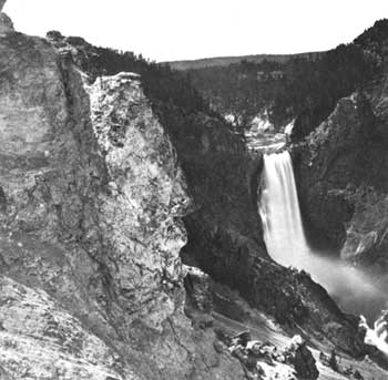
On September 21st, a pleasant ride of eighteen miles over an undulating country brought us to the great cañon, two miles below the falls; [22] but there being no grass convenient, we passed on up the river to a point half a mile above the upper falls, and camped on a narrow flat, close to the river bank. [23] We spent the next day at the falls—a day that was a succession of surprises; and we returned to camp realizing as we had never done before how utterly insignificant are man's mightiest efforts when compared with the fulfillment of Omnipotent will. Language is entirely inadequate to convey a just conception of the awful grandeur and sublimity of this masterpiece of nature's handiwork; and in my brief description I shall confine myself to bare facts. Above our camp the river is about one hundred and fifty yards wide, and glides smoothly along between gently-sloping banks; but just below, the hills crowd in on either side, forcing the water into a narrow channel, through which it hurries with increasing speed, until, rushing through a chute sixty feet wide, it falls in an unbroken sheet over a precipice one hundred and fifteen feet in height. [24] It widens out again, flows with steady course for half a mile between steep timbered bluffs four hundred feet high, and again narrowing in till it is not more than seventy-five feet wide, it makes the final fearful leap of three hundred and fifty feet. [25] The ragged edges of the precipice tear the water into a thousand streams—all united together, and yet apparently separate,—changing it to the appearance of molten silver; the outer ones decrease in size as they increase in velocity, curl outward, and break into mist long before they reach the bottom. This cloud of mist conceals the river for two hundred yards, but it dashes out from beneath the rainbow-arch that spans the chasm, and thence, rushing over a succession of rapids and cascades, it vanishes at last, where a sudden turn of the river seems to bring the two walls of the cañon together. Below the falls, the hills gradually increase in height for two miles, where they assume the proportions of mountains. Here the cañon is at least fifteen hundred feet deep, with an average width of twice that distance at the top. For one-third of the distance downwards the sides are perpendicular,—from thence running down to the river in steep ridges crowned by rocks of the most grotesque form and color; and it required no stretch of the imagination to picture fortresses, castles, watch-towers, and other ancient structures, of every conceivable shape. In several places near the bottom, steam issued from the rocks; and, judging from the indications, there were at some former period hot springs or steam-jets of immense size all along the wall.
The next day we resumed our journey, traversing the northern slope of a high plateau between the Yellowstone and Snake Rivers. [26] Unlike the dashing mountain—stream we had thus far followed, the Yellowstone was in this part of its course wide and deep, flowing with a gentle current along the foot of low hills, or meandering in graceful curves through broad and grassy meadows. Some twelve miles from the falls we came to a collection of hot springs that deserve more than a passing notice. These, like the most we saw, were situated upon a hillside; and as we approached them we could see the steam rising in puffs at regular intervals of fifteen or twenty seconds, accompanied by dull explosions which could be heard half a mile away, sounding like the discharge of a blast underground. These explosions came from a large cave that ran back under the hill, [27] from which mud had been discharged in such quantities as to form a heavy embankment twenty feet higher than the floor of the cave, which prevented the mud from flowing off; but the escaping steam had kept a hole, some twenty feet in diameter, open up through the mud in front of the entrance to the cave. The cave seemed nearly filled with mud, and the steam rushed out with such volume and force as to lift the whole mass up against the roof and dash it out into the open space in front; and then, as the cloud of steam lifted, we could see the mud settling back in turbid waves into the cavern again. Three hundred yards from the mud-cave was another that discharged pure water; the entrance to it was in the form of a perfect arch, seven feet in height and five in width. [28] A short distance below these caves were several large sulphur springs, the most remarkable of which was a shallow pool seventy-five feet in diameter, in which clear water on one side and yellow mud on the other were gently boiling without mignling.
September 24th we arrived at Yellowstone Lake, [29] about twenty miles from the falls. The main body of this beautiful sheet of water is ten miles wide from east to west, and sixteen miles long from north to south; but at the south end it puts out two arms, one to the southeast and the other to the southwest, making the entire length of the lake about thirty miles. Its shores—whether gently sloping mountains, bold promontories, low necks, or level prairies—are everywhere covered with timber. The lake has three small islands, which are also heavily timbered. The outlet is at the northwest extremity. The lake abounds with trout, and the shallow water in its coves affords feeding ground for thousands of wild ducks, geese, pelicans, and swans.
We ascended to the head of the lake, [30] and remained in its vicinity for several days, resting ourselves and our horses, and viewing the many objects of interest and wonder. Among these were springs differing from any we had previously seen. They were situated along the shore for a distance of two miles, extending back from it about five hundred yards and into the lake perhaps as many feet. The ground in many places gradually sloped down to the water's edge, while in others the white chalky cliffs rose fifteen feet high—the waves having worn the rock away at the base, leaving the upper portion projecting over in some places twenty feet. There were several hundred springs here, varying in size from miniature fountains to pools or wells seventy-five feet in diameter and of great depth; the water had a pale violet tinge, and was very clear, enabling us to discern small objects fifty or sixty feet below the surface. In some of these, vast openings led off at the side; and as the slanting rays of the sun lit up these deep caverns, we could see the rocks hanging from their roofs, their water-worn sides and rocky floors, almost as plainly as if we had been traversing their silent chambers. These springs were intermittent, flowing or boiling at irregular intervals. The greater portion of them were perfectly quiet while we were there, although nearly all gave unmistakable evidence of frequent activity. Some of them would quietly settle for ten feet, while another would as quietly rise until it overflowed its banks, and send a torrent of hot water sweeping down to the lake. At the same time, one near at hand would send up a sparkling jet of water ten or twelve feet high, which would fall back into its basin, and then perhaps instantly stop boiling and quietly settle into the earth, or suddenly rise and discharge its waters in every direction over the rim; while another, as if wishing to attract our wondering gaze, would throw up a cone six feet in diameter and eight feet high, with a loud roar. These changes, each one of which would possess some new feature, were constantly going on; sometimes they would occur within the space of a few minutes, and again hours would elapse before any change could be noted. At the water's edge, along the lake shore, there were several mounds of solid stone, on the top of each of which was a small basin with a perforated bottom; these also overflowed at times, and the hot water trickled down on every side. Thus, by the slow process of precipitation, through the countless lapse of ages, these stone monuments have been formed. A small cluster of mud springs near by claimed our attention. [31] They were like hollow truncated cones and oblong mounds, three or four feet in height. These were filled with mud, resembling thick paint of the finest quality—differing in color, from pure white to the various shades of yellow, pink, red, and violet. Some of these boiling pots were less than a foot in diameter. The mud in them would slowly rise and fall as the bubbles of escaping steam, following one after the other, would burst upon the surface. During the afternoon, they threw mud to the height of fifteen feet for a few minutes, and then settled back to their former quietude.
As we were about departing on our homeward trip, we ascended the summit of a neighboring hill, and took a final look at Yellowstone Lake. Nestled among the forest-crowned hills which bounded our vision, lay this inland sea, its crystal waves dancing and sparkling in the sunlight, as if laughing with joy for their wild freedom. It is a scene of transcendent beauty, which has been viewed by but few white men; and we felt glad to have looked upon it before its primeval solitude should be broken by the crowds of pleasure-seekers which at no distant day will throng its shores. [32]
September 29th, we took up our march for home. Our plan was to cross the range in a northwesterly direction, find the Madison River, and follow it down to civilization. Twelve miles brought us to a small triangular-shaped lake, about eight miles long, deeply set among the hills. [33] We kept on in a northwesterly direction, as near as the rugged nature of the country would permit; and on the third day (October 1st) came to a small irregularly shaped valley, some six miles across in the widest place, from every part of which great clouds of steam arose. From descriptions which we had had of this valley, from persons who had previously visited it, we recognized it as the place known as "Burnt Hole," or "Death Valley." The Madison River flows through it, and from the general contour of the country we knew that it headed in the lake which we passed two days ago, [34] only twelve miles from the Yellowstone. We descended into the valley, and found that the springs had the same general characteristics as those I have already described, although some of them were much larger and discharged a vast amount of water. One of them, at a little distance, attracted our attention by the immense amount of steam it threw off; and upon approaching it we found it to be an intermittent geyser in active operation. [35] The hole through which the water was discharged was ten feet in diameter, and was situated in the centre of a large circular shallow basin, into which the water fell. There was a stiff breeze blowing at the time, and by going to the windward side and carefully picking our way over convenient stones, we were enabled to reach the edge of the hole. At that moment the escaping steam was causing the water to boil up in a fountain five or six feet high. It stopped in an instant, and commenced settling down—twenty, thirty, forty feet—until we concluded that the bottom had fallen out; but the next instant, without any warning, it came rushing up and shot into the air at least eighty feet, causing us to stampede for higher ground. It continued to spout at intervals of a few minutes, for some time; but finally subsided, and was quiet during the remainder of the time we stayed in the vicinity. We followed up the Madison five miles, and there found the most gigantic hot springs we had seen. They were situated along the river bank, and discharged so much hot water that the river was blood-warm a quarter of a mile below. One of the springs was two hundred and fifty feet in diameter, and had every indication of spouting powerfully at times. [36] The waters from the hot springs in this valley, if united, would form a large stream; and they increase the size of the river nearly one-half. Although we experienced no bad effects from passing through the "Valley of Death," yet we were not disposed to dispute the propriety of giving it that name. [37] It seemed to be shunned by all animated nature. There were no fish in the river, no birds in the trees, no animals—not even a track—anywhere to be seen; although in one spring we saw the entire skeleton of a buffalo that had probably fallen in accidentally and been boiled down to soup.
Leaving this remarkable valley, we followed the course of the Madison—sometimes through level valleys, and sometimes through deep cuts in mountain ranges,—and on the fourth of October emerged from a cañ, ten miles long and with high and precipitous mountain sides, to find the broad valley of the Lower Madison spread out before us. Here we could recognize familiar landmarks in some of the mountain peaks around Virginia City. From this point we completed our journey by easy stages, and arrived at home on the evening of the eleventh. We had been absent thirty-six days—a much longer time than our friends had anticipated;—and we found that they were seriously contemplating organizing a party to go in search of us.
Nathaniel P. Langford deprecated the importance of the foregoing Cook-Folsom article, stating:
The office of the Western Monthly, of Chicago, was destroyed by fire soon after the publication of Mr. Folsom's account of his discoveries, and the only copy of that magazine which he possessed, and which he presented to the Historical Society of Montana, met a like fate in the great Helena fire. The copy which I possess is perhaps the only one to be found. [38]
However, the office of the Western Monthly, or the Lakeside Monthly as it was called after 1870, was destroyed in the Chicago fire of October 3-9, 1871, so that subscribers had the July 1870 issue for well over a year prior to that holocaust, and it is not as rare as Langford supposed.
There is no way to judge the impact of the Cook-Folsom article, but there is evidence that the information brought back by the Folsom party of 1869 was influential in launching the Washburn party of 1870. N. P. Langford has testified to the inspirational value of this exploration in the following words:
On his return to Helena he [Folsom] related to a few of his intimate friends many of the incidents of his journey, and Mr. Samuel T. Hauser and I invited him to meet a number of the citizens of Helena at the director's room of the First National Bank in Helena; but on assembling there were so many present who were unknown to Mr. Folsom that he was unwilling to risk his reputation for veracity, by a full recital, in the presence of strangers, of the wonders he had seen. He said that he did not wish to be regarded as a liar by those who were unacquainted with his reputation. But the accounts which he gave to Hauser, Gillette and myself renewed in us our determination to visit that region during the following year. [39]
But encouragement was not the whole of Folsom's assistance to the Washburn party; he also provided geographical information. Soon after his return from the Yellowstone wilderness, Folsom took employment in the Helena office of the new Surveyor-General of Montana Territory, Henry D. Washburn. There,, he worked with that other civil engineer and Yellowstone explorer, Walter W. deLacy, and together they turned out a noteworthy map.
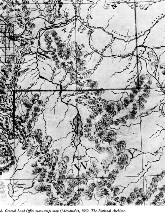
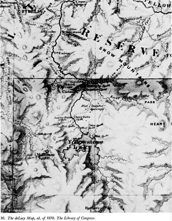
This map, [40] which is endorsed over the signature of Commissioner Joseph S. Wilson of the General Land Office as "accompanying Commissioner's s Annual Report for 1869," was dated at Helena, Mont., November 1, 1869—a mere 21 days after the return of the Folsom party to Diamond City. On it, the Yellowstone region was revealed in greater detail than ever before, and its portrayal was, at last, reasonably accurate (see map 9.). The "Route of Messrs Cook & Folsom 1869" was shown, and along that track, such prominent features as "Gardner's River," with its "Hot Spgs" (Mammoth Hot Springs); the "East Fork," now Lamar River, with "Burning Spring" (Calcite Springs) near its mouth; "Alum Creek" and some thermal features on Broad Creek; the falls of the Yellowstone (the upper noted as "115 ft." and the lower as "350 ft."); "Hot Spgs." noted at the Crater Hills and on Trout Creek, and a "Mud Spring" nearer the outlet of Yellowstone Lake (the Mud Volcano area). The lake was shown as a two-armed body of water, with a "Main Fork" (Upper Yellowstone River) discharging into the large, southern arm, and "Hot Spgs" on the west shore of the bulbous western arm. Interestingly, three islands were clearly shown in the lake (Stevenson, Dot, and Frank), and "Hot Springs" were noted on a point on the northeastern shore (Steamboat Point), and near Pelican Creek.
A new feature added by these explorers was a triangular "Madison Lake," placed west of Yellowstone Lake in accordance with their experience of coming down on the east shore of a large lake after traveling westward from the hot springs at West Thumb. This lake was not recognized for what it was—"Delacy's" or Shoshone Lake—because of an accumulation of mapping errors. Most Yellowstone features are positioned 15 or more miles too far to the west on this General Land Office map, and 11 to 20 miles too far to the north, when compared with present-day maps. However, "DeLacy's Lake," although similarly misplaced in its longitude, is shown only 2 miles north of the correct latitude for its outlet. [41] Thus, when the Folsom party found a large lake nearly 20 miles north of the map position of deLacy's, they failed to relate the two and added a lake which they presumed to be the head of the Madison River, hence its name.
On the Madison River, "Hot Springs" were shown at the head of its southern branch (Firehole River), and both "Hot Springs" and "Geysers" where the eastern branch—presumed to drain "Madison Lake"—joined the former stream. Except for the inconsistencies caused by the introduction of the fictitious "Madison Lake," and omission of Heart Lake and the headwaters of Snake River, the Cook-Folsom information had produced a reasonably good map. How much better it was than the map it superseded [42] is evident at a glance (see map 8).
The information brought back by the Folsom party soon appeared in another form of greater importance than the General Land Office map because of its wider distribution and the fact that a copy was carried through the Yellowstone region by the Washburn party of 1870. A comparison (see map 10), shows that this map had profited from the same improvements apparent on the 1869 General Land Office map, and the usefulness of this 1870 edition of the deLacy map to the Yellowstone explorers of that year is mentioned by Oscar O. Mueller, who says:
Naturally after their return from the exploration trip, they [Cook and Folsom] gave the Surveyor General's Office every possible information they could regarding the region explored and what they had found. W. W. deLacy was employed by the Territory to prepare maps and, therefore, with the assistance of Mr. Folsom, prepared a new map of the Territory of Montana, showing also the north half of the Wyoming Territory. These maps were printed . . . [and] General Washburn took with him, on his exploration trip to the Yellowstone region in 1870, one of these maps and also a copy of the diary of Mr. Cook and Folsom. It can be readily seen, from the inspection of the map covering the Yellowstone region, how valuable an assistance it was to the 1870 expedition. Washburn and Langford were advised to seek a short cut from Tower Falls to the Yellowstone Canyon and Falls. It was this that made General Washburn leave the party at Tower Falls on a Sunday afternoon, and ride up to the top of what is now known as Mount Washburn, from which he could see that the short cut was feasible, and thus they deviated at that point from the route followed by Cook and Folsom in 1869. [44]
While yet employed in the surveyor-general's office—Langford says it was "on the eve of the departure of our expedition from Helena" [45]—Folsom suggested to General Washburn that at least a part of the Yellow stone region should be made into a park. [46]
The contributions of the Folsom party of 1869 to the definitive exploration of the Yellowstone region are these: a descriptive magazine article, a greatly improved map, a suggestion for reservation in the public interest, and the encouragement of the Washburn party of explorers.

Yellowstone Lake, by William
Henry Jackson.
(National Archives)
The motivation that sent the Washburn party into the Yellowstone region in 1870 was largely an outgrowth of two unrelated events of the previous year—the effort to activate the Northern Pacific Railway project, and the struggle over the governorship of the Territory of Montana. Thus, it is necessary to consider these peripheral events before continuing with the definitive exploration of the Yellowstone wilderness.
An act of Congress chartering the Northern Pacific Railway was signed into law by President Abraham Lincoln on July 2, 1864, but the enterprise remained a paper venture (in which the resources provided by the stockholders were consumed without apparent benefit) through 1869. In that year, the board of directors, made desperate by the knowledge, that they would lose both the charter and the munificent land-grant which accompanied it if the prescribed amount of line was not in operation by the end of 1870, turned to the investment house of Jay Cooke & Co., for help. [47]
This marriage of convenience was not consummated at once, for neither group trusted the other. The "old NP faction," headed by J. Gregory Smith—generally addressed as "Governor"—talked of "keeping things in our hands," because "Jay knows nothing of RR Building," [48] and they moved their secretary, the astute and crafty Samuel Wilkeson into an office in New York City, from whence he could advise the Cooke people and divine something of their maneuverings from the city's financial gossip.
The Cooke group, which also included Henry D. Cooke, Pitt Cooke, William G. Moorhead, H. C. Fahnstock, Edward Dodge, John W. Sexton, and George C. Thomas, was not as poorly informed as their distrustful confederates presumed, for they had the excellent counsel of A. B. Nettleton (Cooke's office manager) who, as a general officer in the Civil War, had built and operated many of the railroads which gave the North its logistical superiority in that struggle. These financiers were fearful that the railroaders would waste construction funds in contractual arrangements with cronies, and that the lands available under the railroad's grant—the real security for its bond issues—would be wasted.
The two groups sparred over terms during the remainder of 1869, but finally reached an agreement which gave the banking house representation on the Northern Pacific board and a controlling interest in the railroad's stock in return for an immediate advance of $5 million. [49] That funding allowed construction to begin on the Minnesota shore of Lake Superior, February 15, 1870, on ground thawed with bonfires. [50]
The enterprise thus launched had supporters in and out of the Government, from House Speaker James G. Blaine to Henry Ward Beecher, most of whom had such compelling reasons for their interest as the ownership of Northern Pacific stock or acceptance of gratuities and "fees"; and there were would-bc-friends in the West who sought to ingratiate themselves with the enterprise for various opportunistic reasons. Some of the latter found a measure of acceptance with the Cooke faction, but to the railroaders they were nearly all anathema—a viewpoint which is explained by the following excerpt:
. . . Governor Ashley and a rich man from Toledo, Ohio have put squatters on our pet, our choice, location at Thompson Falls. The choisest and best land on our line of reconnaissance within a year will be gone. [51]
One westerner—a term intended only to designate those men whose sphere of activity was Minnesota and Montana, rather than the financial centers of the East—who nearly made the grade with the old Northern Pacific group was the editor of the Helena Herald. He was introduced to President Smith in these glowing terms penned by Samuel Wilkeson:
Robert E. Fiske—the bearer—is the Republican Editor of Montana—and the Republican brains & heart of that future mighty State.
He loves our Road—Our Road should love & cherish him.
Every syllable of his advice is worth heeding. [52]
But he was not heeded; rather, he was soon considered a "wicked or mean" man, on the advice of one whose contacts were Montana Democrats. [53] The railroaders thus turned their backs on a group which could have been formed into a powerful ally.
The Cooke people were not so disdainful of westerners. They made use of Governor Ashley, even after his true character was all too clear, and they leaned heavily on William R. Marshall, the Governor of Minnesota (1866-70). [54] Quite probably, the latter arrangement included Marshall's brother-in-law, James W. Taylor, [55] that enthusiastic apostle of American economic penetration of the Canadian prairies (which he presumed would eventuate as a "Northern Texas," wrested from British rule by American citizens), but what is important here is the influence of these men—particularly Taylor—on a younger brother-in-law, Nathaniel Pitt Langford. Of this influence, one biographer says:
Langford's story in Montana's early history is well known. That he was an "agent of an agent" there seems little doubt. Indirectly he was an observer and a protagonist for the northern railroad routes. During his time in Montana he seems always to be acting as he would expect Taylor to act and speak if he were there on the scene. His interest in getting Virginia City's gold safely to Washington, and in securing the resources of the area for the Union seem honestly to have been his conscious effort. . . . That N. P. Langford was not James Wicks Taylor is just as obvious, but he did his best. [56]
Taylor, of course, was the source of Langford's political leverage. As a former law partner of Salmon P. Chase (with whom he enjoyed a close ideological rapport), Taylor was able to obtain the position of Collector of Internal Revenue for Montana Territory for his protégé, and he nearly managed the governorship of the territory for him in 1869. [57] Following that defeat Langford gradually became involved in the familial interest—the Northern Pacific Railroad.
Langford, whose diary indicates that he left Montana on October 26, 1869, [58] showed up at the New York office of the Northern Pacific on March 18, 1870. Secretary Wilkeson reported this visit to President Smith in a confidential letter, as follows:
A smart fellow, anciently a bookkeeper—during the war detailed as quartermaster to an expedition from Minnesota overland to Fort Benton and thence through Cadottes, the Deer Lodge & other passes, came in yesterday to get employment. Before he left he asked me if Vibbard & Co. were to have the contract of supplying the Northern Road—and said that he was told by that house the day preceding that they expected to have the contract. Canfield Probably told you of my conversation with Vibbard six months ago on the subject of that contract. I was told then that I was to have an interest in it. [59]
An item which appeared in the Philadelphia Press the day following this visit is so patent a re-statement of James W. Taylor's views that Langford may be suspected of supplying the material to enhance the sale-value of his knowledge of Montana and the northern railroad route. [60] But he was displaying his wares in a poor market, for the railroad could not afford a salary for its secretary at that time.
From April 4 to May 11, Langford accompanied brother-in-law Marshall on a trip to Fort Garry, in British territory. By the middle of the month, Marshall was advocating the construction of a White Cloud-Pembina line to tap the rich Red River Valley (He made several attempts to communicate his enthusiasm for that route to President Smith [61]). As June opened, Langford was in Washington, D.C., in a further attempt to contact Smith. [62]
Though unable to reach the autocrat of the Northern Pacific Railroad, Langford did manage a meeting with Jay Cooke 2 days later. This is noted in Langford's diary as follows:
June 4, 1870, Sat. Met Jay Cooke [illegible] and went to Ogontz [63] with Mr. Cook.
June 5, 1870, Sun. Spent day with Mr. Cook.
What their common interest was remains a matter for speculation, but the directness with which Langford returned to Montana Territory and began organizing the 1870 exploring party hints that the Yellowstone region figured in the conversations. Regardless, Langford had found a place as one of the corps of lecturers who were to expedite the sale of Northern Pacific Railway bonds by popularizing the region through which the line was to be built.
Lower Falls of the
Yellowstone, by William Henry Jackson.
(National
Archives)
From Philadelphia, Langford proceeded to the family home at Utica, N.Y., where he visited briefly before going on to St. Paul, Minn., and a series of pleasant visits with his many relatives in that area. While there, he called upon Maj. Gen. Winfield S. Hancock, who commanded the Military Department of Dakota (of which Montana was then a part), and that officer
. . . showed great interest in the plan of exploration which I outlined to him, and expressed a desire to obtain additional information concerning the Yellowstone country . . . and he assured me that, unless some unforseen exigency prevented, he would, when the time arrived, give a favorable response to our application for a military escort, if one were needed. [64]
Even as Langford was making his plans for a late summer expedition into the Yellowstone region, another interested explorer made an attempt to enter that area. While his venture contributed nothing to the knowledge of Yellowstone's unusual features, it may have influenced the Washburn party in their selection of the Yellowstone River route as the proper approach to the wilderness, and it does expose the vagueness of whatever plan existed locally, prior to Langford's return early in August 1870.
As spring turned to summer, Philetus W. Norris returned to Montana to further his various land schemes along the projected route of the Northern Pacific Railway. Of this visit he says: [65]
At Helena I learned from Gen. Washburn and T. C. Everts that there were rumors of Capt. deLacy, Messrs. Cook and Folsom, and some gold hunters having at various times reached some portions of the Geyser regions, but so far I have failed to find any published or other reliable description of them, or their location or route of reaching them.
Gov. Ashley, Washburn and Everts were talking of a party up the Madison in the following autumn.
Firm in the opinion that the Yellowstone route was the true one, I obtained all possible information here and at Bozeman, and near the latter place found an old used up mountaineer named Dunn, who claimed to have gone with James Bridger and another trapper, who was soon after killed by the Indians in Arizona, via Yellowstone Lake to Green River, in 1865, and, from his statements I made a rough map of their route. [66]
Leaving Everts at Fort Ellis [where he had business with the post sutler], with horse and Winchester rifle, I alone followed the Indian trail through the famous Spring Canon, and left the main pass and trail near the lignite coal bed. I thence crossed the beautiful grassy divide, still full of buffalo wallows, and following a continuous line of rough stone heaps from 2 to 5 feet high, to, and beyond Trail creek an estimated distance of 40 miles from here without seeing a human habitation, to the only one of white men upon the north bank of the Yellowstone.
Norris stopped there for several days with the Bottler brothers—Frederick, Philip, and Henry, [67] enjoying their wild solitude. However,
The main object of my visit being to ascertain the possibility of an exploring party going through the upper cañon and the Lava, or ancient volcanic country beyond, so as to reach the wonders said to be around Yellowstone Lake, several days were spent, with Frederick Bottler as guide, in climbing the Basaltic mountains and dark defiles, the mountain horses of Cayuse characteristics, climbing, like goats or mountain sheep, much of the way. Assured that with the fall of waters a party might in August reach at least the great falls of Yellowstone, we ought to have returned, but believing the Indians were across the next range of mountains upon a buffalo hunt, elated with the wonders found, and hoping to reach greater, and if possible be the first men to reach the Sulphur Mountains and Mud Volcanoes, and possibly the great falls and Yellowstone Lake, we rashly pushed on.
Although the snow-capped cliffs and yawning chasms in the basaltic or ancient lava beds, fringed with snow-crushed, tangled timber and impetuous torrents of mingled hot-spring and melted-snow water, made our progress-mainly on foot, leading our horses—slow, tedious and dangerous, we perservered until near a large river [68] that came dashing down from the Southwestern Madison range. There while crossing a mountain torrent, though the water was not over 20 feet wide and less than knee deep, such was its velocity that Bottler, who first entered, was carried from his feet and swept away much faster than I could follow, and though in great danger of being dashed amongst the rocks, he fortunately caught an overhanging cottonwood and by our united efforts was saved, but his valuable needle-gun, hat, ammunition-belt and equipments went dashing down toward the Yellowstone and were lost.
With my only companion sadly bruised by the rocks, benumbed, the remnants of his dressed elk-skin garments saturated by the snow-water, without gun or pistol, in a snow-bound mountain defile in an Indian country, even a June night was far from pleasant for us.
A morning view with an eight-mile field-glass, though disclosing distant clouds of smoke or spray [Mammoth Hot Springs], yet convinced us both of the utter folly of further effort until melting snows reduced the velocity and number of these mountain torrents, and we should be prepared with more than one gun for procuring food and defence from animals and Indians. As Bottler was unable to climb the mountains, [69] we returned through the unknown second cañon, camping in it while I explored the route.
In a note added at the time he edited these earlier writings for publication (which was never accomplished), he says:
. . . We really visited comparatively little of the Park, yet from a spur of what is now called Electric Peak, we had a fine view of much of it and in returning on the west side of the Yellowstone through its second cañon we explored the route which has been followed by nearly all others, and which is now the main route to the Headquarters of the Park.
In closing the letter in which he forwarded an account of the foregoing exploration to the Norris Suburban, [70] Norris mentioned the choice which he had to make with regard to his activities that summer:
Shall soon decide whether General Washburn, Surveyor General of this Territory, friend Everts and Judge Hosmer, once of Toledo, Major Squier, the Bottlers and our humble self join in another expedition to the unexplored region of the Yellowstone Lake. If so, shall go no farther west this season; if not, shall try to cross the mountains to Oregon, down to Columbia, then to California, and return in autumn.
A footnote to the published letter completes the story. In it Norris adds:
I returned from Missoula to Helena August 1st, 1870, finding Gov. Ashley (who had been active for the Yellowstone expedition), removed, the new Governor (Potts), not arrived, Hauser, Langford and other prominent friends of the enterprise absent, [71] and very little prospect of exploration that year, while the N. P. R. R., and other surveying parties down the Columbia promised various benefits in that direction. With no time to waste in deliberation, I chose the latter, returned to Missoula, assisted in surveying my own and other interests there, and then down the Columbia.
After a month's isolation from news of the outside world, I was intensely mortified to learn that Messrs. Langford's Hauser, and others had returned and gone up the Yellowstone, and at San Francisco also learned that friend Everts was lost near the head of Yellowstone Lake, and though after 37 days of such exposure, starvation and suffering as probably few if any other human beings ever survived, he was found by Baronette and Prichette; yet his horse (the one he used on our return from Fort Ellis), his gun, equipments, and entire outfit, including my map, notes, etc., left with him, were totally lost, and no trace of them has ever been, or perhaps ever will be found.
Having thus, by unforeseen accidents and circumstances not especially the fault of myself or of others, failed in my long cherished hope of a prominent record among the first explorers of the Yellowstone Park, [72] and overtasked with business at home, it was not until 1875 that I again reached my Bottler friends. . . . [73]
Nathaniel P. Langford could not have reached Helena, Mont., before the evening of July 28, and, with a stopover at Virginia City, his arrival could have been later; thus, his statement, "About the 1st of August 1870, our plans took definite shape, and some 20 men were enrolled as members of the exploring party," [74] indicates that he arrived with a matured plan which was embarked upon with little or no delay. He adds:
About this time the Crow Indians again "broke loose," and a raid of the Gallatin and Yellowstone valleys was threatened, and a majority of those who had enrolled their names, experiencing that decline of courage so aptly illustrated by Bob Acres, suddently found excuse for withdrawal in various emergent occupations.
There was a scare about that time, but it seems to have resulted more from the presence of Sioux and Blackfoot Indians near the settlements than from any disposition of the Crows to be unfriendly. The following letter written by 1st Lt. E. M. Camp, who commanded the small guard of soldiers stationed at the Crow Agency (Fort Parker, east of present Livingston, Mont.), clarifies the situation:
Both Sioux and Blackfeet have often been seen near the agency, and there is danger of an attack from them at any time. Both tribes being hostile to whites and Crows. The agency is located Thirty-five (35) miles from Fort Ellis. Wild Country intervening. The Guard at present Consists of one (1) Sergt two (2) Corpls and ten (10) Privates from Co. A 7th U.S. Infantry. [75]
An unsettling note had been struck earlier by the post commander at Camp Baker, who had reported bands of Piegans and River Crows near that place. Both "are believed to be friendly but it is possible some of their young men may commit depredations." [76] Given such tensions, no more than a rumor was required to alarm the fainthearted.
According to Langford:
After a few days of suspense and doubt, Samuel T. Hauser told me that if he could find two men whom he knew, who would accompany him, he would attempt the journey; and he asked me to join him in a letter to James Stuart, living at Deer Lodge, proposing that he should go with us. Benjamin Stickney, one of the most enthusiastic of our number, also wrote to Mr. Stuart that there were eight persons who would go at all hazards and asked him (Stuart) to be a member of the party. Stuart replied to Hauser and myself as follows: [77]
"Deer Lodge City, M.T. Aug. 9th, 1870.
"Dear Sam and Langford:
"Stickney wrote me that the Yellow Stone party had dwindled down to eight persons. That is not enough to stand guard, and I won't go into that country without having a guard every night. From present news it is probable that the Crows will be scattered on all the headwaters of the Yellow Stone, and if that is the case, they would not want any better fun than to clean up a party of eight (that does not stand guard) and say that the Sioux did it, as they said when they went through us on the Big Horn. [78] It will not be safe to go into that country with less than fifteen men, and not very safe with that number. I would like it better if it was a fight from the start; we would then kill every Crow that we saw, & take the chances of their rubbing us out. As it is, we will have to let them alone until they will get the best of us by stealing our horses or killing some of us; then we will be so crippled that we can't do them any damage.
"At the commencement of this letter I said I would not go unless the party stood guard. I will take that back, for I am just d- -d fool enough to go anywhere that anybody else is willing to go,—only I want it understood that very likely some of us will lose our hair. I will be on hand Sunday evening, unless I hear that the trip is postponed. Fraternally Yours,
Jas. Stuart
"Since writing the above, I have received a telegram saying, 'twelve of us going certain.' Glad to hear it,—the more the better. Will bring two Pack horses and one Pack saddle."
Meanwhile, Henry D. Washburn had written Lt. Gustavus C. Doane, an officer of the Second United States Cavalry stationed at Fort Ellis, concerning his interest in the proposed exploration. [79] The answer, which could not have reached Helena before August 14th, advised,
Your kind favor of the 9th ult.—came yesterday—and I reply—at the first opportunity for transmittal. Judge Hosmer was correct as regards my earnest desire to go on the trip proposed—but mistaken in relation to my free agency in the premises. To obtain permission for an escort will require an order from Genl Hitchcock [sic]—authorizing Col Baker—to make the detail.
If Hauser and yourself will telegraph at once on rec't to Genl Hitchcock at Saint Paul, Minn.—stating the object of the expedition &c and requesting that an order be sent to the Comdg officer at Fort Ellis, M. T. to furnish an escort of An Officer five men—it will doubtless be favorably considered—and you can bring the reply from the office when you come down or send it before—if answer comes in time Col Baker has promised me the detail if authority be furnished. And by your telegraphing instead of him—the circumlocution at Dist Hdqrs will be obviated I will reimburse you the expense of the messages which should be paid both ways to insure prompt attention.
I will be able to furnish Tents and camp equipage better than you can get in Helena—and can furnish them without trouble to your whole party.
Hoping that we can make the trip in company. . . . [80]
The wise advice of Lieutenant Doane was taken, for Langford later wrote:
About this time Gen. Henry D. Washburn, the surveyor general of Montana, joined with Mr. Hauser in a telegram to General Hancock, at St. Paul, requesting him to provide the promised escort of a company of cavalry. General Hancock immediately responded, and on August 14th telegraphed an order on the commandant at Fort Ellis, near Bozeman, for such escort as would be deemed necessary to insure the safety of our party. [81]
General Hancock's telegram (sent to Col. John Gibbon at Fort Shaw, on August 15) authorized the expedition in these words:
The Surveyor General of Montana, H. D. Washburn, wishes to determine location of Lake and Falls of Yellowstone and asks for a small escort of an officer and five or ten men. I have no objections to this and would like to have an intelligent officer of cavalry who can make a correct map of the country go along, but the escort should be strong, about a company of cavalry—If there is no obstacle to such an expedition other than is known to me, you can order a company or more from Major Baker's command for this service and suggest to him to go along if he thinks proper and to take charge of the conduct of the expedition unless you desire to go yourself. [82]
The Surveyor General was informed the same day by a telegram stating:
Will send orders to Col. Baker for your escort by Wednesday's mail under cover to you at Helena, so you can take them with you to Ellis. Col. Baker will furnish the escort if he has men to spare. I presume he has them. [83]
The plans of the expeditioners had already appeared in the Helena Daily Herald, [84] where it was noted:
Monday morning at eight o'clock, is the time set for the departure of the long talked of Yellowstone Expedition. The roll has been called, thus far the following gentlemen from Helena have answered to their names promptly, and given an affirmative response: Hon. H. D. Washburn, Surveyor General of the Territory, Hon. N. P. Langford, Hon. Truman C. Everts, late Assessor of Internal Revenue, [85] M. F. Truett, Judge of the Probate Court, Sam'l T. Hauser, President of the First National Bank, Warren C. Gillette, Esq., Cornelius Hedges, Esq., Benjamin Stickney and Walter Trumbell [sic]. Deer Lodge will be represented in the person of James Stuart, of the well known mercantile firm of Dance, Stuart & Co., who has become quite famous in the mountain country as a daring and successful Indian fighter. Boulder Valley, (we are informed by Mr. Langford) will be represented by J. M. Greene, who will join the expedition at Bozeman City. At Fort Ellis, the party will be strengthened by a military escort, consisting of Lieutenant Doan [sic] and twelve men. At the Yellowstone Agency, the party will probably receive another small reinforcement, as Capt. E. M. Camp has signified his intention of going through with the expedition. As a great portion of the country through which they will traverse is claimed by the hostile Sioux, the expeditionists will likely encounter some of these bands of roving Indians, and while it is proper to exercise all necessary precaution against unforseen dangers, we apprehend no serious troubles from this source. It will be remembered, however, that Stuart and his party, during their trip to these almost unexplored regions, in 1863, had a most desperate fight with a band of indians, supposed to have been Crows, which outnumbered them five to one, and it was only by good luck and good generalship combined, that they were saved from a terrible fate. One of the party, we believe was killed in the engagement and two others mortally wounded. We merely refer to this event in order that every man who contemplates this long and dangerous trip, may be prepared for any emergency that may rise. General H. D. Washburn, we understand, has been chosen as commander of the expedition. [86] The General will make a safe and trusty leader, and if it becomes necessary to fight the Indians, he will always be found at the post of duty.
P.S. Since the above was in type, we learn the time for departure has been postponed until Wednesday next [17th], one of the party—Mr. Stuart of Deer Lodge, having business that will detain him until then.
On the 16th, the same newspaper noted that Colonel Gibbon's telegram authorizing a military escort had been received, adding: "The Herald, which will send a reporter along, will furnish its readers with important letters from various points as opportunity and the limited facilities for transmission will afford." [87]
The departure of the expedition from Helena had been set for 9 a.m. on Wednesday, August 17, but difficulties with the pack stock caused a delay noted thus by the Herald:
It was not until two o'clock yesterday afternoon, when the Yellowstone exploring party took their departure from the rendezvous on Rodney street, and even then all did not get off. Several of the party, we are informed, were "under the weather" and tarried in the gay Metropolis until "night drew her sable curtain down," when they started off in search of the expedition. The party expected to make their first camp about twenty miles from the city. [88]
Cornelius Hedges, who was really not an outdoors person, characterized the start as a "dismal day of dust, wind and cold," [89] while Samuel T. Hauser put it this way in his rudimentary diary: "considerable bother getting off—started 1 p.m.—3 packs off-within 300 yards—sent back for a second pack[er]—Left packers and Darkeys." [90] He also identifies one of the revelers left behind when the main party cantered out of town about 4 in the afternoon; following Ben Stickney's name in his roster of the expedition's personnel, Hauser added, "tight." The other—from his absence from Hedges' list of those who went together to the "half-way house" run by Nick Greenish 4 miles from Helena—could only have been Jake Smith.
After a night during which Hedges "Didn't sleep at all—dogs bothered," the party reached Vantilburg's by noon, and as it "Started in snowing just as we got in, voted to stay." Hedges' diary also contains this confession: "I felt very sore and was glad of rest." Of this layover, Hauser noted: "All playing cards."
An early start the following morning got them to Major Campbell's by 2:30 p.m., where dinner was ordered at once. Gillette says:
. . . but the shrewd old man kept us waiting till 6 O clock in order to compell [sic] us to stay all night. There was much growling from hungry men but a good supper of chicken & trout, good coffee & cream, with a desert of blanc-mange restored the party to its former good humor. [91]
Langford, who had pushed on alone, reached Bozeman about 7 p.m. on the 19th, which gave him time to arrange with Major Baker for their escort before the other expeditioners arrived the following day. [92] The party put up at the Guy House, and entered upon a lively evening which included a cold supper provided by the proprietors of the firm of Willson & Rich. Gillette thought they were "nine pretty rough looking men to come into the presence of three fine ladies," and Hedges was "much embarrassed" because all had white collars but himself. Afterward, Langford and Hedges called at Gallatin Lodge No. 6 of the Masonic Order, where Langford, as Grand Master, placed the charter in arrest as the best means of ending a grievous dispute. Then everyone went to the Guy House for champagne and musical entertainment at the rooms of Captain and Mrs. Fiske.
Cornelius Hedges described Sunday the 21st as "all commotion, running around, saying goodbye, talking with Masons. Sperling gave box of cigars. Everyone kind, with many good wishes." He also noted:
Went out to camp near Fort & cook our dinner. Lieut Doane brought us a big tent & helped us put it up. shelter from wind, sun & cold. . . . Unpacked our things to get what we wanted. read papers. Jake Smith opened a game & got busted in a few moments. [93] visted by several prospectors who tell us much about the country.
Hedges' mood had changed for the better as the day of departure from Fort Ellis arrived, perhaps as a consequence of that "fine bed and sleep," and the gaiety of that "merry company." He also recorded a note of dissent that would reappear occasionally: "Smith is disgusted at prospect of standing guard," then penned a last-minute dispatch to the Herald, [94] and the Yellowstone Expedition was ready to enter the wilderness.
The official report prepared by Lt. Gustavus C. Doane immediately following the return of the expedition is the best account written by a member. [95] Therefore, the details that follow have been taken from his report unless otherwise noted.
Doane's report, which is prefaced by an extract from Special Order No. 100, issued at Fort Ellis, Montana Territory, August 21, 1870, begins:
In obedience to the above order, I joined the party of General H. D. Washburn, in-route for the Yellowstone, and then encamped near Fort Ellis, M.T. with a detachment of F. Co 2d Cavalry, consisting of Sergeant William Baker, Privates Chas. Moore, John Williamson, William Leipler and George W. McConnell.
The detachment was supplied with two extra saddle horses, and five pack mules for the transportation of supplies. A large pavillion tent was carried for the accommodation of the whole party, in case of stormy weather being encountered; also forty days rations and an abundant supply of ammunition.
The party of civilians from Helena consisted of General H. D. Washburn, Surveyor General of Montana, Hon. N. P. Langford, Hon. T. C. Everts, Judge C. Hedges of Helena, Saml T. Hauser, Warren C. Gillette, Benj C. Stickney, Jr., Walter Trumbull, and Jacob Smith, all of Helena, together with two packers, and two cooks. [96]
They were furnished with a saddle horse apiece, and nine pack animals for the whole outfit: They were provided with one Aneroid Barometer, one Thermometer, and several pocket compasses, by means of which observations were to be taken at different points on the route.
The route from Fort Ellis was the same as that followed by the Folsom party the previous year, with the first encampment on Trail Creek, about 15 miles from the Post. [97]
On the second day, August 23, 1870, the party made 20 miles, which brought them to the Bottler Ranch. The only incident the lieutenant found worth noting was the sighting of a few Indians, who were casually dismissed with the entry, "In the afternoon we met several Indians belonging to the Crow Agency 30 miles below." [98]
Rain began in the evening, so that the pavillion tent had to be put up near the Bottler cabin. [99]
The weather cleared the following morning and camp was moved up the river to a pleasant place below what Doane called "the lower cañon" [100]—present Yankee Jim Canyon, which is really the second canyon going upstream, and was so called until the mid-eighties. It was evident they were in Indian country, so guards were posted and the horses were picketed or hobbled.
On the 25th, the party made their way through Yankee Jim Canyon on a difficult Indian trail, [101] then debouched into an arid valley. Continuing on the west bank of the Yellowstone, they past that "Red Streak Mountain" some prospectors had earlier thought to contain cinnabar, [102] to an encampment at the mouth of Gardner River. [103] Doane called this "our first poor camping place, grass being very scarce, and the slopes of the ranges covered entirely with sage brush," and he added, "From this camp was seen the smoke of fires on the mountains in front, while Indian signs became more numerous and distinct." [104]
The route on the 26th followed what would later be known as the "Turkey Pen Road," and Lieutenant Doane, Everts, and Private William son went ahead as an advance party. Contact with the main group was soon lost due to the latter's difficulty with pack animals made nervous by smoke from the burned-over area on Mount Everts. Thus, the train was unable to follow Doane through to Tower Fall, but had to camp for the night on what Langford called "Antelope Creek"—present Rescue Creek— but which was designated more accurately by Hauser as "Lost Trail Creek," because they lost Doane's trail near the marshy pond on that stream.
Doane, who was following the trail of two "hunters" (probably miners from nearby Bear Gulch), [105] had turned south in order to get on the Bannock Indian trail which passed directly over the Blacktail Deer Plateau, well back from the nearly impassable "middle cañon." [106] That heavily used trail led the advanced party to the first thermal springs on their route—a tepid, sulphurous outflow near present Roosevelt Lodge—and on to Warm Spring Creek, [107] where they camped with the hunters they had been following.
The next day, August 27, while waiting for the main party to come up, Doane had an opportunity to examine the hot springs scattered along the Yellowstone from the mouth of Tower Creek nearly to the entry of Lamar River, and he had time to contemplate the chief feature of the locality, Tower Fall, [108] which he typified in these words:
Nothing can be more chastely beautiful than this lovely cascade, hidden away in the dim light of overshadowing rocks and woods, its very voice hushed to a low murmur unheard at the distance of a few hundred yards. Thousands might pass by within half a mile and not dream of its existence, but once seen, it passes to the list of most pleasant memories.
The remainder of the party arrived that afternoon, and it was decided there was enough to see in the vicinity to justify a layover; thus, a pleasant camp was established where the party remained during the 28th. [109] It was there that the felon on Lieutenant Doane's right thumb was first opened, "three times to the bone, with a very dull knife," in the hope of providing him with relief from his "infernal agonies," but without success. [110]
On August 29, the party broke camp and proceeded toward the falls of the Yellowstone by the route General Washburn had pioneered the previous day. [111] Those who went to the summit of Mount Washburn took a reading from which Doane computed the elevation as 9,966 feet above sea level. [112]
It was while passing over the Washburn Range that these explorers were at last convinced they were entering a land of wonders. Of the view from Dunraven Pass, Doane wrote:
A column of steam rising from the dense woods to the height of several hundred feet, became distinctly visible. We had all heard fabulous stories of this region and were somewhat skeptical as to appearances. At first, it was pronounced a fire in the woods, but presently some one noticed that the vapor rose in regular puffs, and as if expelled with a great force. Then conviction was forced upon us. It was indeed a great column of steam, puffing away on the lofty mountainside, escaping with a roaring sound, audible at a long distance even through the heavy forest.
A hearty cheer rang out at this discovery and we pressed onward with renewed enthusiasm.
Camp was made that evening on the stream that drains most of the southern side of Mount Washburn, [113] and the evening was spent investigating several prominent thermal features nearby. [114] This exploration took them to the rim of the Grand Canyon, which Doane likened to "a second edition of the bottomless pit."
The move made the following day was short—only 8 miles, to a campsite on the lower edge of the meadows on Cascade Creek. With much of the afternoon left for exploring, the members of the party made their way toward the falls singly and in small groups. [115] The views obtained convinced all that there was enough more to see that they were warranted in again laying over a day. Accordingly, the last day of August was also passed in exploring the locality.
Langford proceeded to measure the drop of both the Upper and Lower Falls of the Yellowstone by the same method the Folsom party had used in 1869, and with an identical result at the Upper Fall. [116] Hauser and Stickney managed to scramble down into the Grand Canyon 2-1/2 miles below the Lower Fall, [117] while Lieutenant Doane and Private McConnell climbed down to some hot springs bordering the river a mile farther down the canyon. Hedges, who was less active, spent several hours viewing the Lower Fall, then wandered along the canyon rim until filled with "too much and too great satisfaction to relate." It was Doane's opinion that:
Both of these cataracts deserve to be ranked among the great waterfalls of the continent. No adequate standard of comparison between such objects, either in beauty or grandeur can well be obtained.. . [but] In scenic beauty the upper cataract far excels the lower; it has life, animation, while the lower one simply follows its channel; both how ever are eclipsed as it were by the singular wonders of the mighty cañon below.
The expedition left the camp on Cascade Creek on September 1, moving southward through Hayden Valley. In contrast to the wild flood which foamed powerfully through the Grand Canyon, the Yellowstone River, where it flows through the grasslands created by the shrinkage of Lake Yellowstone, is slow-flowing and sedate—described by Doane in these words:
The stream here changes its character altogether, running in the center of an open glade, back full, with grassy margins, a slow current, and spread out to a width of from two hundred to four hundred feet. The bottom is pebbly, or quick-sand, the water of crystal clearness, and cold again.
Two miles above the Upper Fall, they came to a swampy stream, west of the river, which Doane mistakenly called Alum Creek, [118] while another, nearly opposite, was similarly misidentified as "Hellroaring River." [119] In the middle of the valley was a group of hills which Doane wanted to call the "Seven Hills," [120] where they found an interesting array of sulphurous hot springs and vents. Some time was spent examining the locality, but a lack of drinkable water induced them to move 5 miles farther up the valley before camping.
This camp, where the expedition lay over on the 2d, was a half mile north of the Mud Volcano and quite close to the feature now called the Sulphur Cauldron. The drinking water obtained from the river tasted of chemicals, but the fishing was fabulous. Among the nearby springs was the first true geyser seen on the trip, [121] as well as features identifiable as Dragons Mouth Spring (a green-gabled grotto called "Cave Spring" by Gillette) and the Mud Volcano. [122] The last was described by Doane as follows:
A few hundred yards from here is an object of the greatest interest. On the slope of a small and steep wooded ravine is the crater of a mud volcano, thirty feet in diameter at the rim, which is elevated a few feet above the surface on the lower side and bounded by the slope of the hill on the upper, converging as it deepens to the diameter of fifteen feet at the lowest visible point, about forty feet down. Heavy volumes of steam escape from this opening, ascending to the height of three hundred feet. From far down in the earth come a jarring sound in regular beats of five seconds with a concussion that shook the ground at two hundred yards distant. After each concussion, came a splash of mud as if thrown to a great height; sometimes it could be seen from the edge of the crater but none was entirely ejected while we were there. Occasionally an explosion was heard like the bursting of heavy guns behind an embankment and causing the earth to tremble for a mile around. These explosions were accompanied by a vast increase of the volumes of steam poured forth from the crater. This volcano has not been long in operation, as young pines crushed flat to the earth under the rim of mud, were still alive at the tops.
On September 3 the main party crossed the Yellowstone River at what would later be known as the "Nez Perce ford," while Washburn and Langford rode back to the hot springs in Hayden Valley and a scary experience there. [123]
The trail on the east side of the river was good as far as the crossing of a marshy stream east of present Fishing Bridge settlement. [124] There the pack train mired and had to make a detour of several miles. A good campsite was found on the shore of Lake Yellowstone, near the Beach Springs and about a half-mile east of the Folsom party's encampment.
The party again delayed a day, a halt made necessary by the condition of Doane's hand. He had been suffering severe pain for a number of days and loss of sleep had taken its toll of his strength. Another operation was performed soon after arrival at the lake. [125] With relief from the inflammation, Doane slept through the night, the following day, and a second night.
Meanwhile, the other members of the party spent the time playing cards, exploring the nearby hot springs and that beach Hedges called the "Curiosity Shop." The presence of islands (Stevenson, Frank, and Dot), which were thought never to have been "trodden by human footsteps," encouraged the building of a raft for the exploration of those shores, but the waves of the lake dashed it to pieces within an hour of the launching. Nor was that the only unproductive effort; the triangulation attempted on the 5th, following the breaking of camp, was equally futile. [126]
The decision to follow the east shore of the lake upon leaving the "Hot Spring Camp" was a result of a reconnaissance made in that direction by General Washburn while the party awaited Doane's recovery. However, that route around the lake eventually proved more difficult than expected.
Fifteen miles were traveled the first day, to an overnight camp at Park Point, but the increasing difficulty with fallen timber reduced their progress on the 6th to 10 miles. Even so, the route was not so onerous but what some members of the party could be spared to make an excursion into a Brimstone Basin lying east of the trail. [127] It was toward the end of the day that they encountered a really formidable obstacle. An attempt to cross the estuary of the Upper Yellowstone River by following the beach fronting on the lake got the pack train into a difficult cul-de-sac, so that they camped that night in considerable anxiety about the route. [128]
On the following morning, General Washburn went ahead to find a way through the estuarial swamps, while Langford and Doane climbed a nearby peak to get a better view of the entire region south of Lake Yellowstone. Doane noted: "We were 4 hours reaching the highest point, climbing for over a mile over shelly feldspathic granite after leaving our horses at the limit of pines." He found the summit to have an elevation of 10,327 feet (by aneroid barometer). [129] Doane's description of the country as seen from the summit is interesting:
The view from this peak commanded completely the lake enabling us to sketch a map, [130] of its inlets and bearings with considerable accuracy. On the southwestern portion of the lake rose a high mountain of a yellow rock [Mount Sheridan], forming a divide or water shed in the centre of the great basin beyond which the waters flowed south and west.
The stream we failed in crossing on the previous day rises in the south east range running east several miles and joining another stream from the south west at Bridgers lake, a sheet of water about two miles in diameter at the foot of a rocky peak about twenty five miles to the south from whence, the stream flows due north in a straight valley to the Yellowstone lake.
This valley has a uniform width of about three miles is level and swampy through its whole extent with numerous lakelets of considerable size scattered at intervals over its surface. South of Bridgers lake and beyond the snake river divide were seen two vast columns of vapor thirty miles away which rose at least five hundred feet above the tops of the hills. [131] They were twenty times as large as any we had previously seen but lay a long distance out of our course and were not visited.
Looking east one mountain succeeds another with precipitous ravines volcanic, rugged, and in many places impassable, as if all the fusible portions of the mountains had melted and run away leaving a vast cinder behind. There were no ranges of peaks it was a great level plain of summits with the softer portions melted out, the elevations all coming up to the same level and capped with horizontal beds of surface lava. This formation extended to the limit of vision. The deep and narrow valleys were grassed and timbered, had sparkling streams and furnished basins for numbers of small lakes; in fact there are lakes here everywhere on the summits of mountains and on their terraced slopes in valleys, and in ravines, of all sizes, shapes and qualities of water.
On descending from the peak, Langford and Doane followed the trail of the main party to their encampment on the lakeshore, southwest of the Molly Islands. The information brought back was so helpful that General Washburn later gave Langford's name to the peak climbed with Doane, while the lieutenant's name was given to a lower summit north of the saddle where the horses were left; but the Hayden Survey did not allow either name to remain as intended.
The following morning, September 8, Hedges and Everts climbed the prominent elevation which rises above the southern extremity of the Southeast Arm (this is not truly a mountain, but only the northern end of Two Ocean Plateau), and the facility with which Everts found his way back to camp created an unwarranted confidence in his woodsmanship. [132]
The difficult terrain encountered beyond the Southeast Arm limited the party's progress on the 8th to about 7 miles, airline, so that they camped on Grouse Creek, east of Channel Mountain. Doane notes: "In the evening a Grizzly Bear with cubs was roused by some of the party, but as they had not lost any bears she got away with her interesting family undisturbed." [133] He adds, in regard to their general lack of success in hunting, "our party kept up such a rackett of yelling and firing as to drive off all game for miles ahead of us."
On September 9 the party crossed Chicken Ridge, north of Channel Mountain, and descended onto Surprise Creek, where they encamped in a meadow near its head. They had been so entangled in "fallen timber of the worst description," and so preoccupied with getting the pack train through, that Everts was not missed until he failed to come into camp. Even then, there was no particular alarm (several men went back along the trail and signal guns were fired), for it was thought Everts could make his way to the agreed rallying point at the hot springs on West Thumb. Hedges reflected the general feeling in his diary: "All in but Everts and we felt well around the fire."
A short move on the 10th took the party over a shoulder of Flat Mountain, to an encampment on Flat Mountain Arm. From there, men went back along the trail and into the country on each side searching for the lost man. Hauser and Langford ascended the height above camp and fired the woods to create a beacon, but all these measures were unavailing.
All were now convinced that Everts had gone to the rendezvous point, so camp was moved again on the 11th—northwesterly, to the shore of West Thumb, near the mouth of Solution Creek. From that camp, searchers went out by pairs on the following day. Trumbull and Smith followed the beach entirely around the promontory that holds Delusion Lake without finding anything more than some human footprints in the sand. Washburn and Langford rode southward toward the "yellow mountain" (Mount Sheridan), turning back just short of Heart Lake when Langford's horse broke through the turf into hot mud which severely scalded his legs. [134] Hauser and Gilette checked the back-track and came near being lost also, [135] while Lieutenant Doane went around to the West Thumb Geyser Basin and searched there.
The party remained encamped on West Thumb the 12th, 13th, 14th, and 15th, searching constantly despite the intermittent snow storms which brought the depth of snow on the ground to 20 inches.
On September 16 camp was moved to the West Thumb Geyser Basin as the first step in extricating the party from a situation which was rapidly becoming hazardous for all. The near exhaustion of their rations, the continuing storminess of the weather, and the fatigue of the entire party all indicated the wisdom of an immediate withdrawal from the Yellowstone region. Such was the wish of all the expeditioners except Gillette, who remained behind with two soldiers when the return to the settlements was begun on the 17th. [136]
The route of the main party was westward, about as the highway now goes between West Thumb and Old Faithful. DeLacy Creek and the large lake seen to the left of their line of travel were assigned to the "Fire Hole branch of the Madison" by Doane, but Langford placed them properly. [137] A night camp was made on the head of Spring Creek.
Continuing the march on the 18th, the Firehole River was reached in about 3 miles, and, soon after, they passed "two fine roaring cascades," of which Doane remarked:
These pretty little falls if located on an eastern stream would be celebrated in history and song; here amid objects so grand as to strain conception and stagger belief they were passed without a halt. [138] Shortly after, the cañon widened a little and on descending on a level with the stream, we found ourselves once more in the dominions of the Fire King.
The Upper Geyser Basin came into view suddenly as they were riding along the east bank of Firehole River, and, just at that moment, Old Faithful Geyser began to play. That grand display caused the entire cavalcade to bolt through the river in their haste to reach what was the first major geyser found by the expedition. [139] Lieutenant Doane's journal
This valley is known in the wretched nomenclature of this region as the Fire Hole, [140] and contains phenomena of thermal springs unparalleled upon the surface of the globe. Crossing the river we moved down to a central point of the valley and camped in a little grove of pine timber near the margin of a small marshy lake around which were to be seen numerous fresh signs of Buffalo driven out by the noise of our hasty intrusion.
From their camp west of Firehole River and nearly opposite the Lion group of geysers, the expeditioners scattered out through the basin observing and naming geysers. [141] The marked regularity of the geyser seen in action as they arrived led General Washburn to designate it Old Faithful—a spouter which had more than punctuality to recommend it, as Doane noted:
Those who have seen stage representations of Aladdins Cave and the home of the Dragon Fly, as produced in a first class theatre, can form an idea of the wonderful coloring but not of the intricate frost work of this fairy like yet solid mound of rock growing up amid clouds of steam and showers of boiling water. One instinctively touches the hot ledges with his hands and sounds with a stick the depths of the cavities in the slope, in utter doubt in the evidence of his own eyes. The beauty of the scene takes away ones breath. It is overpowering, transcending the visions of Masoleums Paradise, the earth affords not its equal, it is the most lovely inanimate object in existence.
To the west of their encampment, across the marshy lake (which has since been drained), stood the largest geyser cone in the basin; a "castelated turret 40 feet in height and 200 feet in circumference at the base," which they called "The Castle" from its resemblance to an old feudal tower partially in ruins.
Down the river a few hundred yards beyond Castle Geyser was another with a cone described as "resembling a huge shattered ham," which, considering the size of its aperture (7 feet in diameter) and the length of its play (3 hours), was thought to be the greatest of all the great geysers, and so was named "The Giant." [142] Doane says: "While playing, it doubled the size of the Firehole River."
Two hundred yards farther they found a peculiar cone consisting of pillars and interstices, suggestive of a grotto, and it was named accordingly. [143] Beyond that was a peculiar geyser which alternated steam and fanlike jets in a cycle which continued for hours. [144]
Across the river from their encampment, on an extensive ridge of "formation" (silicious sinter, or geyserite, produced by the action of hot water on igneous rock and redeposited on cooling), was a large well which erupted its contents—a body of water 20 by 25 feet—into the air to the height of 90 feet, with individual jets rocketing to 250 feet. This great fountain, which played for 20 minutes, was considered a fit companion for The Giant and so was called "The Giantess."
Another geyser on the same side of the river took the party quite by surprise, as Doane noted:
29th day This morning we were awakened by a fearful hissing sound accompanied by falling water, and looking out saw on the other side of the stream a small crater three feet in height and with an opening of twenty six inches in diameter which had scarcely been noticed on the previous day, and was now playing a perpendicular jet to the heighth of two hundred and nineteen feet with great clouds of steam escaping, and causing the ground to tremble as the heavy body of water fell with tremendious splashes upon the shelly strata below.
Huge masses of the rocks were torn from their places and borne away into the river channel. it played thus steadily for ten minutes giving us time to obtain an accurate measurement by triangulation which resulted as above stated. . . . Its appearance and size were altogether insignificant compared with others. [145]
Though convinced that further observation would discover other great geysers in that basin, the near exhaustion of their supplies required them to move on. Thus, the pack train moved out on the morning of September 19, the remainder of the party following toward noon. They stopped briefly at the Grand Prismatic Spring and noted a 50-foot jet playing from a large crater nearby. [146] But they passed through the Lower Geyser Basin with no more than a vague awareness of its thermal riches.
Lieutenant Doane's preconceived idea of the Madison drainage led him to show an entirely fictitious headwater for that stream, including a large "Madison Lake" south of the Upper Geyser Basin. [147] The encampment that evening was at the junction of the Firehole and Gibbon Rivers, the accepted "head" of the Madison River. [148] It was from there that the party had their last view of the Yellowstone's thermal activity, which Doane described as follows:
September 20th. We now thought ourselves clear of the geysers but in the morning were surprised to see a graceful column of steam ascending to the heighth of three hundred feet on the opposite side of the creek and in the elbow of a mountain range.
We did not visit this group [Terrace Spring, on Gibbon River], but forded the Madison twice just below camp and followed down its right bank.
The party soon passed into the Madison Basin—the "Burnt Hole" of the trappers—where they were beyond the boundary of the present Yellow stone National Park. The evening of the 22d they camped within sight of settlers' cabins in the Madison Valley, and Langford rode into Virginia City the following morning with news of the loss of Truman C. Everts. [149] Lieutenant Doane reached Fort Ellis on the 24th, [150] and the Helena contingent—excepting Gillette—were all home by the evening of September 27.
The progress of the small party which remained in the Yellowstone wilderness to search for the lost Everts is detailed by Gillette, who wrote in his diary:
Had no trouble in reaching the snow Camp but after passing that a storm came on and we bore to [sic] far to the south camping on the Lake this side of where we intended. Met a man in the woods, who said he was one of a party of 4 who came up Snake river and were camped near our Snow Camp. [151] from his illy repressed nervous manner took him for a man who was fleeing justice. told him of the loss of Everts. I killed a chicken to day with my pistol. roasted it this evening. was very sweet.—with our Fish it made a good meal Kept a sharp look out for any signs or tracks of Everts or his horse. but could see none. It rained nearly all night & my bed which was in a hollow was partly filled with water
Sept 18 Sunday. The weather this AM looked fair, but after we were well on the way, a drenching rain came on & we camped while it was still raining about 2 miles from our camp of the 10th and 11th. Williamson left Moore & myself to make a shelter (which we did with poles & blankets) while he went out to hunt. in about an hour we heard him halow in the mountain, heard his shots first. Moore took the mule & went to where we heard the shots & returned with a fine fat 2 Year old Heifer Elk we ate the liver, for supper I must not forget that I killed another chicken to day with my pistol., of which I feel quite proud. We are in high spirits. Weather cleared and looks well for to morrow
Sept 19th We left camp early this A.M. passing up the south end of the Lake, going easterly. Found the provision we left for Everts at our camp of the 10th untouched showing that he has not made his way to this part of the lake. About a mile above this camp we turned up the Mountain to the South found our old trail, the snow having almost entirely disappeared.
We passed our camp of the 9th (which has been burned over by the fire we left.) and followed down a stream below where we crossed the same day. (9th) with the train. Camped on this creek [Surprise Creek]. After supper looked for signs of Everts on the creek. Saw none.
Sept 20th This morning got an early start. Took Moore with me, leaving Williamson in camp. (his horse being lame) we went back about a 1/2 mile found our trail on the east side of the creek, which we followed back to the point when Everts was supposed to have left us,—looked carefully to find in what direction he went. Saw tracks on a trail which led down over a steep side-hill. here we lost the tracks, but kept on It took us to a small pond [Outlet Lake], the outlet of which ran S W. we followed it to its mouth which was 6 or 7 miles from our camp south. Seeing an opening in the trees on the opposite side of the creek into which it emptied, we went over and discovered a good sized lake, say 2 by 3 miles wide & long. [152] Examined carefully for any signs of a fire or horse tracks, saw none We crossed at the outlet of lake, and kept down the stream, which is here almost a river for a distance of 6 miles, where it opened out into a large basin across which large mountains could be seen. We were satisfied this stream was the head of Snake river, as it was getting late we retraced our steps and arrived in Camp a little after dusk
Sept 21st I had determined that night to go over the Mountain on the right bank of the creek on which we were camped, but a storm being imminent this morning and the men anxious to get away before a snow fell so as to obliterate the trail, & the rations being light also, I abandoned the idea, and thought it better to go to the lake at once. I hated to leave for home, while there was a possibility of finding poor Everts but the chance of our finding him being so very small, even if we knew in which direction he went, that I turned our horses northward, hoping, to hear, when we arrived at the settlements, that he had gotten out of the mountains, and would be found at Virginia City or Helena Nothing of note has occurred to day. We found the meat we "cached" all right, and after a hard & long days march (as the soldiers say) have reached our camp of the 16th The wind is blowing strong from the N.E. but with a fine shelter made with poles & blankets, shall sleep soundly. Where is the poor man Everts is he alive? is he dead? in the mountains wandering, he knows not whither? or back home safely. Did he kill his horse? if so I wonder how he likes Horseflesh With dried horse meat he could live 30 or 40 days. How he must have suffered even at the best! The reflection that he may be within 10 or 15 miles of us [sic].
Sept 22d [no entry]
Sept 23rd Camped on the Madison River this noon, in the midst of an innumerable number of Hot Springs, & real Geysers. I write this from the top of a mound at least 30 feet higher than the surroundings formed by a Geyser which at present does not throw water out of its Crater. The water comes near the top & hot steam is issuing continually with heavy roaring irregular sound. This mound is 40 feet in width & circular being cone shaped. it is of a whitish, grey color and composed of soda lime & a little sulphur.
24th Traveled to day down the Madison going over some of the worst fallen timber we have seen. during the fore part of the day. This afternoon the way was better as to timber but many marshy places. Hot springs occur all along our route to day some upon the opposite side of the river that I did not examine. Travelled on the right bank followed the Margin of the river till we came to the Cascades when we took to the timber and camped in the forks of a large river coming from the south East. Traveled to day, say 20 miles Tried fishing my only fly was taken off and could get no bites from meat bait
25th Left camp early this AM Keeping the margin of river The river still to our left after going some 6 or 8 miles we went up on a trail to our right supposing it to lead north but found when we were on the Mountain that the trail was lost. The view amply repaid us for the labor. A broad basin lay like a Map before us white capped mountains in the S.W. & to the north & immense forests of pine covered the whole country we passed down into the basin [Madison Basin] . . .
Gillette and the two soldiers continued in the wake of the main party, and Gillette reached Helena on October 2 with his unhappy confirmation of a fact already too apparent—Everts was certainly lost.
The first information about the Yellowstone expedition which the press was able to provide to the public concerned the loss of Everts, which was reported thus in the Helena Daily Herald: [153]
We are in receipt, this afternoon, of a dispatch from Virginia City, dated 23d, announcing the arrival there of N. P. Langford, of the Yellowstone expedition, who brings the sad intelligence of the loss of Truman C. Everts, ex-United States Assessor, who was one of the party. The members of the expedition spent eight days hunting for him in the mountains, but found no trace of him. No particulars have come to hand.
LATER
Just before going to press the following special dispatch to the HERALD was received:
Virginia City, September 23.
General H. D. Washburne, commander of the Yellowstone expedition, with his party, camped on the Madison, opposite Virginia City, last night, and will he in Helena next Monday. Hon. T. C. Everts was lost September 9th, in the dense forests on the south side of the lake. The party searched seven days for him without discovering any traces of him. Warren C. Gillette and two cavalrymen remained to make further search, the others giving them all their provisions, except enough to subsist them until they reached home. The party made accurate maps of the Lake and river.
Nothing more was available on the Yellowstone region and its wonders until the 26th, when the Helena Daily Herald devoted two columns of its front page to the "Interesting Data of the Trip, from Notes Furnished by Hon. N. P. Langford." [154] The following is this brief account which introduced the party's discoveries:
The party left Bozeman the 22nd of August, reaching the Yellowstone on the 24th, and traveling up that river until the 27th, when they reached the Lower Fall creek [Tower Creek], where they remained in camp one day. On this creek is the Lower Fall, a beautiful cascade 115 feet high. The Indian trail crosses the Yellowstone at this point to the east side, but the party kept upon the west side of the river, near the base of Mt. Washburn, a peak 10,570 feet in height, passing the Hellbroth Springs on the 29th, and on 30th camping opposite the Great Falls of the Yellowstone, on Cascade creek. Nearly two days were spent in examining the Falls and their surroundings. Mr. Langford suspended a weight perpendicularly from the rock adjoining the Falls, 491 feet to the bottom of the cañon, and deducting from this the distance from the top of the rock to the surface of the water above the Fall, found it to be 350 feet in height. The Upper Fall, half a mile further up the stream, is 115 feet high. A day and a half more brought the party to the Hot Sulphur and Mud Springs, sixty to seventy-five in number, of diameters varying from two to seventy feet. From scores of craters on the side of the mountain adjoining these springs, issue hot vapors, the edges of the craters being incrusted with pure sulphur. Six miles further on is the first geyser, which throws a column of water twenty feet in diameter in the height of thirty to thirty-five feet. Nearby is a volcano, which throws up mud from the bottom of its crater to the height of thirty feet or more, with explosions resembling distant discharges of cannon, the pulsations occurring at intervals of five seconds, and the explosions shaking the ground for a long distance. This volcano has evidently been in existence but a short time—a few months—as the newly grown grass was covered for nearly two hundred feet with the clayey mud that was thrown out at the first outbreak. The crater of this volcano is about thirty feet in diameter at its mouth, and is narrowed down to a diameter of fifteen feet at a depth of twenty feet from the top, and the surface of the mud down in the crater appeared, when for a few seconds it was in a quiescent state, to be about sixty feet below the mouth of the crater.
At this point the party forded the river, and traveled along the east bank twelve miles to the Yellowstone Lake, a beautiful sheet of water of very irregular shape, but of an average length of twenty-two miles, and width of fifteen miles. An accurate map of the lake was made from observations taken by Messrs. Hauser and Langford, from the tops of three mountains on different sides of the lake. One of these mountains was 11,200 feet high, as measured by the barometer.
The journey around the lake was rendered very difficult by the fallen timber, the party sometimes halting at night not more than six or seven miles from their morning camp.
From the lake the party struck off to the Fire Hole River, on which, in the Geyser Basin, they found a most remarkable collection of springs and craters. In the basin, which extends about two miles down the river, and is a mile in width, are between seven and eight hundred springs and craters of all diameters, from two to one hundred feet. The party found here twelve geysers, five of which threw columns of water to heights varying from ninety to one hundred and fifty feet, the columns being from three to twenty feet in diameter. The column of water from the sixth was discharged from the apex of a conical-shaped mound, through a nozzel two feet by three, and rose to the height of two hundred and nineteen feet, Messrs. Hauser and Langford carefully measuring the column by triangulation.
We learn the following concerning the loss of Mr. Everts: He was with the rest of the party at noon on September 9th, all slowly working their way through the fallen timber. In making search for a passage through it, one or another of the members of the party would, for a brief time, become separated from the main body, but would readily find his way back again. At two o'clock p.m., the company camped for the night,—all being present but Mr. Everts. In camp it was found that Mr. Hedges' packhorse, which had that day rolled down a steep hill, thirty or forty feet, with his pack on his back, was missing and Mr. Langford, with the two packers, went in search of him, finding him about two miles from camp and returning about five o'clock, but discovering no sign of Mr. Everts.
The objective paint of the party at this time was the southwest arm of the lake, and any one lost or separated from the train would have pushed on to that point. On the morning of the 11th Lieutenant Doan [sic], Langford and Hauser, leaving the train, pushed on with provisions to this arm of the lake, confidently expecting to find Mr. Everts, but no trace of him could be discovered. The rest of the party reached the lake at night, and all remained at that point five days longer. Messrs. Gillette and Hauser, the following day, returned on the trail, four days march, or near to the camp occupied by the party two days before Mr. Everts was lost, but could discover no trace of him—the trail made by the thirty-seven horses belonging to the party being in many places entirely obliterated. Messrs. Trumbull and Smith followed the shore of the lake, and General Washburne and Mr. Langford traveled south to the head waters of Snake river, but neither party could find any trace of the lost man. While in camp on the lake, snow fell to the depth of two feet. An inventory of provisions was then taken, and on the 17th, eight days after the loss of Mr. Everts, most of the party started for the Madison, with sufficient supplies to carry them home, leaving Mr. Gillette and Messrs. More and Williamson, of the 2nd cavalry, with the balance of the provisions to prosecute the search.
It was the opinion of all the members of the party, when Mr. Langford left them on the Madison, that if Mr. Everts had not then been heard from in Virginia or Helena, he had been shot by Indians. The only route that he could have taken that would not have brought him to Virginia or Helena a week since, is that leading by the 'Three Tetons' to Eagle Rock Bridge, which point he could have reached several days ago; and had he done so, would undoubtedly have telegraphed his friends here.
It is the intention of Mr. Langford to prepare for publication, as soon as practicable, a detailed report of the journey to and from this most interesting portion of our country, where, in a space so circumscribed, are presented at once the wonders of Iceland, Italy, and South America.
General Washburn's account of the trip through Wonderland appeared in two installments, [155] subtitled "Explorations in a New and Wonderful Country." This account was the first written by a member of the Washburn party (the brief account already presented was prepared by the editor from Langford's notes), and it was also the first account of the party's discoveries to go beyond the boundaries of Montana Territory. Thus it is of more than ordinary interest. The text follows:
As your readers are aware, the Yellowstone Expedition left Ft. Ellis on the 22d of August, through the Bozeman Pass, [156] finding it all that the Bozemanites claim for it easy and practicable—and camped for the first night on Trail creek, having a fine view of the mountains beyond the Yellowstone. The next day they struck the valley, and their journey up the river commenced. They camped for the night at the ranch of Mr. Bottler, the last settler up the river. Crow Indians were quite plenty during the day, and a heavy rain at night gave anything but a pleasing aspect to the commencement of the trip; but a bright sun, about 10 o'clock, made everything right, and we moved to the cañon of the river [Yankee Jim Canyon], about fourteen miles distant and camped on one of the loveliest spots in Montana. Two small streams put in from the east from an elevation near camp. The river and valley can be seen stretching away far to the north, the river bank plainly defined by the trees skirting its margin. South, the river can be seen pouring through the canon; while far away to the east and west the mountain peaks were then covered with snow—the setting sun brightening both in its last rays, before night's mantle was thrown over the party.
We passed through the cañon next morning, and found it about six miles long—the trail leading us along the side of the torrent, and sometimes hundreds of feet above it. Night found us at the mouth of Gardiner river, a fine mountain stream coming from the south, and entering the Yellowstone just below the Grand Canon, over thirty miles in length and nearly equally divided by the east fork [Lamar River]. The canon proving impracticable, we took to the mountains, camping one night in them, and the next night a few miles above. The river runs for sixteen miles in nearly a due west course here. Our camp was on a fine stream coming in from the opposite side of the east fork, and designated by us as Tower Creek. The camp was called Camp Comfort. Game and trout were abundant. We found here our first hot springs, small but attractive, and of five or six different kinds—sulphur, iron, etc. This canon of the river is grand. Basaltic columns, of enormous size, are quite numerous. But the great attraction here was the falls on the creek, near our camp. The stream is about as large as the Prickly Pear, and for a mile rushes down with fearful velocity. It seems at some time to have been checked by a mountain range, through which it has torn its way, not entirely removing the barrier, hut tearing through, leaving portions still standing; and these, by the elements, have been formed into sharp pinnacles. Looking from the canyon below, it appears like some old castle with its turrets dismantled but still standing. From between two of these turrets the stream makes its final leap of 110 measured feet, and then, as if satisfied with itself, flows peacefully into the Yellowstone. We attempted to compare it with the famous Minne-ha-ha, but those who had seen both said there was no comparison. It was not as terrible in its sublimity as Niagara, but beautiful and glorious. You felt none of the shrinking back so common at the Great Fall, but rather, as you stood below and gazed upon its waters broken into white spray, you felt as though you wanted to dash into it and catch it as it fell. By a vote of the majority of the party this fall was called Tower Fall.
The cañon of the main river here runs in a southwest direction. The party crossed over a high range of mountains [Washburn Range], and in two days reached the Great Falls. In crossing the range, from an elevated peak a very fine view was had. The country before us was a vast basin. Far away in the distance, but plainly seen, was the Yellowstone Lake. Around the basin the jagged peaks of the Wind River, Big Horn, and Lower Yellowstone ranges of mountains, while just over the lake could be seen the tops of the Tetons. Our course lay over the mountains and through dense timber. Camping for the night eight or ten miles from the falls, we visited some hot springs that, in any other country, would be a great curiosity; boiling up two or three feet, giving off immense volumes of steam, while their sides were incrusted with sulphur. It needed but a little stretch of imagination on the part of one of the party to christen them, "Hellbroth Springs." Our next camp was near the Great Falls, upon a small stream running into the main river between the Upper and Lower Falls [Cascade Creek]. This stream has torn its way through a mountain range, making a fearful chasm through lava rock, leaving it in every conceivable shape. This gorge was christened the "Devil's Den." Below this is a beautiful cascade, the first fall of which is five feet, the second twenty feet, and the final leap eighty-four feet. From its exceedingly clear and sparkling beauty it was named Crystal Cascade.
Crossing above the Upper Falls of the Yellowstone, you find the river one hundred yards in width, flowing peacefully and quiet. A little lower down it becomes a frightful torrent, pouring through a narrow gorge over loose boulders and fixed rocks, leaping from ledge to ledge, until, narrowed by the mountains and confined to a space of about eight feet, it takes a sudden leap, breaking into white spray in its descent a hundred and fifteen feet. Two hundred yards below the river again resumes its peaceful career. The pool below the falls is a beautiful green capped with white. On the right hand side a clump of pines grew just above the falls, and the grand amphitheatre, worn by the maddened waters on the same side, is covered with a dense growth of the same. The left side is steep and craggy. Towering above the falls, half way down and upon a level with the water, is a projecting crag, from which the falls can be seen in all their glory. No perceptible change can be seen in the volume of water here from what it was where we first struck the river. At the head of the rapids are four apparently enormous boulders standing as sentinels in the middle of the stream. Pines are growing upon two of them. From the Upper Fall to the Lower there is no difficulty in reaching the bottom of the cañon. The Lower Falls are about half a mile below the Upper, where the mountains again, as if striving for the mastery, close in on either side, and are not more than seventy feet apart. And here the waters are thrown over a perpendicular fall of three hundred and fifty feet . The canon below is steep and rocky, and volcanic in its formation. The water, just before it breaks into spray, has a beautiful green tint, as has also the water in the canon below. Just below, on the left hand side, is a ledge of rock from which the falls and canon may be seen. The mingling of green water and white spray with the rainbow tints is beautiful beyond description.
This cañon is a fearful chasm, at the lower falls a thousand feet deep, and growing deeper as it passes on, until nearly double that depth. Jutting over the cañon is a rock two hundred feet high, on the top of which is an eagle's nest which covers the whole top, Messrs. Hauser Stickney and Lieut. Doan [sic] succeeded in reaching the bottom, but it was a dangerous journey. Two and a half miles below the falls, on the right, a little rivulet [Silver Cord Cascade], as if to show its temerity, dashes from the top of the canon and is broken into a million fragments in its daring attempt.
After spending one day at the falls we moved up the river. Above the falls there is but little current comparatively for several miles, and the country opens into a wide, open, treeless plain. About eight miles from the falls, and in this plain, we found three hills, or rather mountains, thrown up by volcanic agency, and consisting of scoria and a large admixture of brimstone. These hills are several hundred feet high, and evidently are now resting over what was once the crater of a volcano. A third of the way up on the side of one of these hills is a large sulphuric spring, twenty feet by twelve, filled with boiling water, and this water is thrown up from three to five feet. The basin of this spring is pure solid brimstone, as clear and bright as any brimstone of commerce. Quite a stream flows from the spring, and sulphur is found encrusting nearly everything. Near the base of the hills is a place containing about half an acre, but covered with springs of nearly every description,—yellow, green, blue and pink. Flowing from the base of the hill is a very strong spring of alum water—not only alum in solution, but crystallized. This place we called Crater Hill, and as we passed over, the dull sound coming from our horses feet as they struck, proved to us that it was not far through the crust. All over the hill were small fissures, giving out sulphurous vapors. The amount of brimstone in these hills is beyond belief.
Passing over the plain we camped on the river bank, near a series of mud springs [Mud Volcano area]. Three of the largest were about ten feet over the top and had built up ten or twelve feet high. In the bottom of the crater thus [erected mud was] sputtering and splashing, as we have often seen in a pot of hasty pudding when nearly cooked. Near these we found a cave under the side of the mountain, from which was running a stream of clear but very hot water [Dragon's Mouth Spring]. At regular intervals the steam was puffing out. For some time we had been hearing a noise as of distant artillery, and soon we found the cause. Some distance above the level of the river we found the crater of a mud volcano, forty feet over at its mouth. It grew smaller until at the depth of thirty feet, when it again enlarged. At intervals a volume of mud and steam was thrown up with tremendous power and noise. It was impossible to stand near, and one of the party, Mr. Hedges, paid for his temerity in venturing too close by being thrown backward down the hill. A short time before our visit, mud had been thrown two or three hundred feet high, as shown by the trees in the vicinity. Not far from this we found our first geyser [Mud Geyser]. When discovered it was throwing water thirty or forty feet high. The crater was funnel-shaped, and seventy-five by thirty-five feet at its mouth. We stayed and watched it one day. Without warning it suddenly ceased to spout, and the water commenced sinking until it had gone down thirty feet or more. It then gradually commenced rising again, and three times during the day threw up water thirty or forty feet.
The next day we recrossed the river [157] and succeeded in reaching the lake, and camped on the lower end . The fishing, which had been good all the way up the river, proved remarkably so in the lake. Trout, from 2 to 4 pounds, were to be had for the taking. Flies proved useless, as the fish had not been educated up to that point. Remaining over Sunday, we took up the line of march around the south side of the lake, which took us through a dense growth of pine, filled with fallen timber. The third [fourth] day's march was over a mountain, and but little progress was made, the train going into camp about 2 o'clock. Mr. Everts failed to come into camp—but this occasioned no uneasiness, as we had all expected to reach the lake, and believed he had pushed on to the lake, as he had once before done, and was awaiting our arrival. Moving on five miles we struck an arm of the lake, but found no trace of him. A party was sent down the shore, and two other parties to climb adjacent mountains to search for him, and to build fires on them to attract his attention. Next morning, no news being heard of him, a council was held and the camp moved to the main lake, and search commenced vigorously, but without avail. The fourth night [158] a snowstorm commenced and continued for two days, rendering the search during that time impossible. The situation of the party was becoming precarious; away from the settlements, no trail, without a guide, and snow covering the ground. Another council was held, and it was determined that it was best to move towards the settlements. Mr. Gillette volunteered to stay and prolong the search, and two soldiers were left with him. Mr. Gillette is one of the best mountain men of the party, and there is hope that he may bring some tidings of the missing man. On the south end of the lake is a very beautiful collection of hot springs and wells—in many the water is so clear that you can see down fifty or a hundred feet. The lake is eight thousand feet [7,733] above the level of the sea, a beautiful sheet of water, with numerous islands and bays, and will in time be a great summer resort, for its various inlets, surrounded by the finest mountain scenery, cannot fail to be very popular to the seeker of pleasure, while its high elevation and numerous medicinal springs will attract the invalid. Its size is about twenty two by fifteen miles.
Leaving the lake we moved nearly west, over several high ranges, and camped in the snow amid the mountains. Next day about noon we struck the Fire Hole river and camped in Burnt Hole valley [Upper Geyser Basin]. This is the most remarkable valley we found. Hot springs are almost innumerable. Geysers were spouting in such size and number as to startle all, and are beyond description. Enormous columns of hot water and steam were thrown into the air with a velocity and noise truly amazing. We classified and named some of them according to size.
No. 1. The Giant, seven by ten feet, throwing a solid column of water from eighty to one hundred and twenty feet high.
No. 2. The Giantess, twenty by thirty, throwing a solid column and jets from one hundred fifty to two hundred feet high.
No. 3. Old Faithful, seven by eight, irregular in shape, a solid column each hour seventy-five feet high.
No. 4. Bee Hive, twenty-four by fifteen inches, stream measured two hundred and nineteen feet.
No. 5. Fan Tail, Irregular shape, throwing a double stream sixty feet high.
No. 6. is a beautiful arched spray, called by us the Grotto, with several aperatures [sic], through which, when quiet, one can easily pass, but when in action, each making so many vents for the water and steam.
Upon going into camp we observed a small hot spring that had apparently built itself up about three feet. The water was warm but resting very quietly, and we camped within two hundred yards of it. While we were eating breakfast, this spring, without any warning, threw, as if it were the nozzle of an enormous steam engine, a stream of water into the air two hundred and nineteen feet, and continued doing so for some time, thereby enabling us to measure it, and then suddenly subsided.
Surrounded by these hot springs is a beautiful cold spring of tolerable fair water. Here we found a beautiful spring or well. Raised around it was a border of pure white, carved as if by the hand of a master work man, the water pure. Looking down into it one can see the sides white and clear as alabaster, and carved in every conceivable shape, down, down, until the eye tires impenetrating [sic].
Standing and looking down into the steam and vapor of the crater of the Giantess, with the sun upon your back, the shadow is surrounded by a beautiful rainbow, and by getting the proper angle, the rainbow, surrounding only the head, gives that halo so many painters have vainly tried to give in paintings of the Savior. Standing near the fountain when in motion, and the sun shining, the scene is grandly magnificent; each of the broken atoms of water shining like so many brilliants, while myriads of rainbows are dancing attendance. No wonder then that our usually staid and sober companions threw up their hats and shouted with ecstasy at the sight.
We bid farewell to the Geysers, little dreaming there were more beyond. Five miles beyond Burnt Hole we found the "Lake of Fire and Brimstone." In the valley we found a lake measuring four hundred and fifty yards in diameter, gently overflowing, that had built itself up by deposit of white substrata, at least fifty feet above the plain. This body of water was steaming hot. Below this was a similar spring, but of smaller dimentions [sic] while between the two, and apparently having no connection with either, was a spring of enormous volume flowing into the Madison [Firehole River], and is undoubtedly the spring which Bridger has been laughed at so much about, as heating the Madison for two miles below. For some distance down the river we found hot springs and evidences of volcanic action. Our passage down the river was a little rough but generally very pleasant, and on the evening of the 22nd we reached the first ranche on the Madison, where we found a paper dated September 1st, the latest news from the inside world. Next day we went to Virginia for papers, and soon found that the world had been moving.
Our trip was a grand success, only marred by the loss of one of our number. If he is merely lost there is still hopes of his return, as he had a good horse and plenty of ammunition and matches. The danger is that he has been killed by the Indians for his horse and gun.
H.D.W.
The return of the Washburn party appears to have received little notice outside Montana Territory. The earliest report, evidently based on the scanty information received by telegraph, was published at Salt Lake City and contained nothing of particular interest, being only a brief note to the effect that the "Yellowstone exploring expedition" had returned to Helena after accurately determining the height of "the falls" and the location of lakes. There was no mention of the finding of hot springs and geysers, but the loss of Everts was mistakenly coupled with a sanguinary event in Idaho Territory. [159]
A more adequate presentation of the expedition's findings followed the receipt of the Helena Herald articles of the 27th and 28th by newspapers with which an exchange was maintained by mail. The Denver, Colorado, Rocky Mountain News reprinted that part of General Washburn s account concerned with the thermal wonders of the Upper Geyser Basin, prefacing it with this statement:
There are a great many wonderful things in the West, and many wonderful stories are told regarding them. From the Montana Herald's account of the recent Yellowstone expedition, we take the following, which while it may interest and astonish the reader, will also draw somewhat on his powers of credulity. [160]
Such skepticism prompted a Montana editor to vouch for the explorers. He reminded his journalistic brethren:
As we have not published these accounts, our statement may be taken as that of a disinterested witness. We assure our contemporaries outside of Montana, that the expedition was composed of intelligent and reliable gentlemen, and that their published reports are entitled to and receive the fullest credence in Montana. [161]
That the information provided by Langford and Washburn did not seem incredible to more sophisticated editors is evident from the fact that the St. Paul, Minn., Pioneer Press reprinted the Washburn and Langford accounts in full, and without comment, [162] while the New York Times had this to say of General Washburn's narrative: [163]
Accounts of travel are often rather uninteresting, partly because of the lack of interest in the places visited, and partly through the defective way in which they are described. A poetic imagination may, however, invest the dreariest spots with attraction, and the loveliest nooks of earth may seem poor and arid if sketched with a dullard's pencil. But, perhaps, the most graphic and effective descriptions of actual scenery come from those "plain people," as Mr. Lincoln would have called them, who, aiming at no graces of rhetoric, are unconsciously eloquent by the force of simplicity.
A record of the Yellowstone Exploring Expedition, which has just happened to reach us, is distinguished by this graphic directness and unpretending eloquence. It is partial and fragmentary, but it reads like the realization of a child's fairy tale. We mean no disparagement, but the reverse, of the Notes of the Surveyor-General of Montana, in saying this. No unstudied description that we have read of the internal scenery of the American Continent, surpasses his notes in any particular. The country he had to describe certainly offers great advantages. But it is much to his credit that he has performed the task in so unpretending a manner. Where temptation to fall into the besetting sins of tourists is great, the merit of avoiding them is equally great.
A review of Washburn's account was concluded with a statement in which the editor of the Times again commented favorably upon it, noting,
We have said that this record reads like a fairy tale, and readers will by this time agree with us. Its official character, however, may be added to the evidence of that simplicity of style already commended as earnest of the trustworthiness of the narrative. Rarely do descriptions of nature come to our hands so unaffectedly expressed, and yet so gilded with true romance.
Despite the foregoing evidences of newspaper reportage varying from undisguised scoffing to excessive enthusiasm, it is probably a fact that the early reports made little impression on the public. Such great and influential papers as the Philadelphia Public Ledger, St. Louis Times, and San Francisco Chronicle were either unaware of, or uninterested in, the Yellowstone region. The Portland Oregonian, which was certainly neither, made no mention of the Washburn party, though it devoted nearly a column to a meaningless account of a visit to the Yellowstone Falls obtained from the Bozeman Montana Pick and Plow. [164]
Word of what the explorers had found in the Yellowstone wilderness appears to have reached New York City at least 4 days prior to publication of the Times article. In a letter to Jay Cooke on October 10, the Northern Pacific's crotchety secretary, Samuel Wilkeson, complained: "The villains in Helena are wholly uncovering the nakedness of our sleeping Yellowstone Beauty. It breaks my heart." [165] That lament was based on the desire of the railroaders to lay claim to the choice lands along their line under the provisions of the grant allowed by the Congress, and advance publicity could only defeat their objective. It also hints that they had some knowledge of the Yellowstone region and were even then thinking of its possible value to their future development plans.
Locally, the interest in the Langford and Washburn articles was so great that the Helena Daily Herald announced on September 30: "We to-day reproduce the articles of both these gentlemen, and print a large number extra of the paper to supply the public demand." And before that interest had waned, Warren C. Gillette was back from his vain search for Everts.
Gillette's negative report furnished the material for a lengthy newspaper article of considerable interest because of the dreadful possibility it raised in connection with Everts' disappearance. In this, [166] the public was informed:
While making their way through the forest they suddenly came upon a man mounted on a grey horse. Mr. Gillette asked him if there were any others with him. He replied that there were three others. Mr. Gillette asked him what they were doing up there. With much hesitation and stammering, as if at a loss what reply to make, he finally answered with assured nonchalance, that they were fishing and trapping. He also said that the others were in camp near the lake shore at a point which was but a short distance from the five days' camp of the whole Yellowstone party, before leaving the lake. The general appearance of the man was so bad, and his actions so suspicious, that Mr. Gillette's party were all fully convinced that he was an outlaw or fugitive from justice. They soon after, in a more open part of the woods, found the trail of the party, plainly discernable in the snow, and made by eighteen or twenty horses, all or nearly all unshod. Among them were the tracts [sic] of a colt. It was evident, from the appearance of the trail, that there were more than four men, as the evenness and uniformity of the trail through the snow plainly evidenced the fact that it was made by horses under the saddle and not by loose or packed animals; there being but comparatively few tracts outside of the trail, in the snow.
They followed this trail a mile or more, but as it was storming hard at the time they finally left it, and as they had in the meantime lost their own reckoning, they struck off to the right, finding the trail of the party and then leaving it again, when their efforts were diverted to the task of determining their own position in respect to the lake, which was the first thing to be done before any systematic search with any hope of final success could be instituted.
And here we may properly refer to a circumstance to which allusion was made in our issue of September 28th A lot of horses having been stolen near Pleasant valley [on the Montana stage route], a party of men followed the thieves up a branch of Snake river, and on the 10th of September accidentally came to the place where General Washburn's party camped September 9th, the day Mr. Everts was lost. Near this point they lost trace of the thieves, who had evidently succeeded in secreting themselves somewhere in the fallen timber. [If] Mr. Everts, in his wanderings, had accidentally struck the trail of the horse thieves and had followed it (for he would have followed any trail) until he came near where they were concealed; Can it be doubted that they, seeing a man approaching them armed with a needle-gun, revolver, and a belt full of cartridges, would have concluded that he was one of the pursuing party on their trail, and would have shot him at once?
We have conversed with Messrs. Gillette, Hauser and Langford, whose experience here for the past eight years, and knowledge of the desperate character of the horse thieves and road agents that infest Montana, and familiarity with all the circumstances that may be even remotely connected with this most unfortunate affair, entitle their opinions to the fullest weight, and they are of the opinion that there is but little hope that Mr. Everts can be alive Mr. Gillette thinks he probably perished during the storm that prevailed the fourth and fifth days after he was lost, rather than that he met his death at the hands of the road agents or Indians. Messrs. Hauser and Langford, on the other hand, think it more probable that he has been shot by horse thieves or Indians—Mr. Hauser favoring the former idea, and Mr. Langford the latter.
All of the party, however, are fully agreed that any further search for Mr. Everts will be entirely fruitless, as in that dense and almost interminable forest, in which the ground was covered with fallen timber, through which their pack train could move but from six to eight miles a day, a thousand men might search a month and find no trace of a lost man. The pine leaves were lying so thickly upon the surface of the ground, that the tracks of nearly forty horses, (shod) belonging to the expedition, trailing one another, were hardly discernable two hours after they were made.
We feel fully assured that everything has been done for the recovery of Mr. Everts that humanity can suggest, and to Mr. Gillette is due the highest credit and the gratitude of all our citizens for the fidelity with which he has discharged the trust voluntarily assumed in behalf of the members of the Yellowstone expedition.
Fortunately for the lost man, the rescue efforts were not allowed to rest there. Judge Lawrence, the law partner of Cornelius Hedges, offered a reward for the recovery of Everts. [167] Contained in the announcement was word of yet another attempt to find Everts:
A party consisting of two men, George A Pritchett and John Baronet, [168] was organized and outfitted in this city, yesterday, and left this morning for the Yellowstone country, to search for the Hon. T. C. Everts, who was lost in the mountains on the 9th ult. Messrs. Pritchett and Baronet will proceed to the Crow Agency, procure the services of two or three Indians, follow up the trail of the Expedition to the lake, where Mr. Everts was lost, then commence their search. These men are both familiar with the country, having visited it last Summer, a year ago, are well supplied with provisions, blankets, arms, ammunition and everything necessary for such a trip. They also have with them a map of the Yellowstone Lake and adjacent country, drawn by Col. S. T. Hauser. Messrs. Pritchett and Baronet propose to remain until the deep snows of winter drive them back, unless they shall have succeeded in finding the lost man before that time.
Judge Lawrence, of this city, has offered a reward of $600 for the recovery of the lost man.
The Herald's own correspondent with the Yellowstone expedition, Cornelius Hedges, produced nothing for that paper until 2 weeks after his return, and that beginning appears to have been prompted by a desire to honor the yet lost Everts. His article, entitled "Mount Everts," is descriptive both of the man and of the eminence overlooking the southeast arm of Yellowstone Lake which they had climbed together. The text follows: [169]
To the Editor of the Herald:
Please allow me, through your columns, to relate an incident connected with the recent trip of the Yellowstone party, to which subsequent events have added melancholy interest. It occurred at our first camp on the south shore of Yellowstone Lake, where we bivouacked on the evening of September 7. On that day, by a long detour through tangled thickets and fallen timber, through swampy flats surrounding the inlet of the Yellowstone River into the lake of the same name, we had reached a point but little farther east than we had made the day before, and been compelled to retrace our steps by reason of impassable sloughs. We no longer had any sort of trail, and the difficulties of traveling were multiplying upon us; besides, the southern lake shore is very irregular—long promontories or points jutting out from the mainland for miles into the lake. It became to all of us a matter of first importance to curtail our route by making cuts across the necks of these points. With that object in view, General Washburn and myself, after pitching camp and disposing of supper, took a ramble to spy out a route for our next day's drive. At about a mile from camp, in nearly a due-east course, we came upon a game trail, passed an old Indian tepee at least a year old, skirted a little lake about 50 feet above the main lake, snugly tucked up about the foot of a high, bold, bluffy point partly open and partly covered with standing and fallen timber. At that time we only ascended a short distance, as the sun had already set and we were not altogether fresh after the scratching and floundering of the day's journey. We were anxious to know what could be seen from the top of that mountain, and Mr. Everts proposed to me that I should go with him as soon as breakfast was over in the morning, September 8. Accordingly we went. He manifested much eagerness to go and seemed in more than usual good spirits. The point reached the night before was soon passed, and we stood upon what appeared as the top seen from the base, but we found it but one step to a much bolder point, whose base was concealed from our view below. Not knowing the persistency of the man, I asked him if we had better go to the top, and his quick response was, "By all means." The sides of this mountain were in places so nearly perpendicular that we made slow and labored progress. Sometimes losing our foothold, we would slide back several feet. In one instance I lost ground about 4 rods and was indebted to a dwarf pine for not losing more distance and perhaps even worse consequences. Thrice we halted on what seemed from below to be the summit, and still we found the top beyond us, which we reached by a final desperate attempt, making the last 50 feet by drawing ourselves up, grasping projecting rocks along the face of an almost perpendicular ledge of dark, coarse, conglomerate rock. Here we stood on a broad, level, rocky rim to a high plateau, pine covered as it receded, which commands a most magnificent view of the whole lake and the dark-green piney basin in which it nestles. In admiration of the pluck and perseverance of my companion, I told him that point should be named Mount Everts. During the half hour we remained on this mountain, probably 12,000 [1,200] feet above the lake's surface, we traced almost its entire outline, as well the part that we proposed to traverse as that over which we had already come. We could even see through a gap in the easternmost of the southern promontories the blue waters of the southeast [West] arm of the lake, near which we expected to take our departure for the headwaters of the Madison. I then noticed, with some surprise, that with his glasses he could see such distant features as I called to his notice. We examined, as minutely as time allowed, the intervening space, tracing out what we thought the most practicable route across the necks of several points reaching miles away into the lake. This was only the day before he got separated from us, and so strong was my faith that he knew our course and would appear at some point in our advance that I scarcely entertained a fear till we finally reached the farthest point where we left the lake.
In descending the mountains Mr. Everts took a shorter line to camp than that by which we came, while I was unwilling to take any chances of missing my way, and returned as I went. I found Mr. Everts in camp when I reached it. It increased greatly my confidence in his good judgment as a woodsman.
The company, of course, assented to my proposed name for the mountain we had visited, and let future tourists respect this monumental record. What more fitting monument can transmit to future generations the name of our lamented companion? As it towers in self-complacent grandeur above the beautiful lake, and serenely marks the passage of storms, and seasons, and centuries, Mount Everts seems a fitting type of that noble, self-reliant spirit, destined, as we fear, so soon after to be quenched by a dismal fate in the wooded wilderness near its base.
The hope of his rescue so long deferred makes the heart sicken with gloom. Baffled in all our hopes, we incline to believe that he became a victim to the gang of desperadoes that, flying from hot pursuit by way of Snake River, found their refuge in the impenetrable forests and swamps of the south shore of Yellowstone Lake. It is some melancholy satisfaction, should the mystery of his fate never be cleared up, that I had some instrumentality in providing for him so fitting a monument as Mount Everts.
Yours truly,
CORNELIUS HEDGESHelena, October 8,1870
The slowness of Cornelius Hedges to get into print is explained in a letter written on October 2 to an eastern newspaper. [170] His description of the trip as far as Tower Fall was concluded with the statement: "I would try to write you more but the territorial fair and district court, in addition to arrears of business leave me little prospect of doing more at present." Likewise, he wrote his father at the time, "If I were not overcrowded with business at present I would write you an account of some of the objects of wonder that I saw on my recent trip." [171]
With the "Mount Everts" article, Hedges had begun his series describing Yellowstone features: "The Great Falls of the Yellowstone, A Graphic Picture of Their Grandeur and Beauty" appeared in the Helena Herald's issue of October 15; "Hell-Broth Springs," on October 19; "Pictures of the Yellowstone Country—Sulphur Mountain and Mud Volcano," on October 24; and "Yellowstone Lake," on November 9. [172] The last is of more than ordinary interest because it contains the only statement to come from the pen of a member of the Washburn party, prior to inception of the park movement, proposing reservation of Yellowstone features in the public interest. This statement is contained in the following paragraph:
This beautiful body of water is situated in the extreme northwest corner of Wyoming, and, with its tributaries and sister lakes of smaller dimensions, is entirely cut off from all access from any portion of that Territory by the impassable and eternally snow-clad range of the Wind River Range of mountains. Hence the propriety that the Territorial lines be so readjusted that Montana should embrace all that lake region west of the Wind River Range, [173] a matter in which we hope our citizens will soon move to accomplish, as well as to secure its future appropriation to the public use.
A close examination of this suggestion shows it to have two distinct parts: one, calling for inclusion of what is essentially the present park within the Territory of Montana, and the other calling for a dedication to an undefined "public use." There is no way of divining what public use Cornelius Hedges had in mind, for he never elaborated the idea. But subsequent statements in the Montana press indicate that a grant to the Territory of Montana, similar to the grant made to the State of California of the Yosemite Valley and Big Trees, was desired by some influential persons. [174] Thus it is entirely possible Hedges was thinking in the same terms.
How influential Hedge's published suggestion was is speculative. The only evidence of contemporary publication outside of Montana thus far found is a clipping from the Independence (Iowa) Conservative. [175]
Publicity during the period immediately following the return of the Washburn party was dominated by the Helena Herald. However, the rival Rocky Mountain Gazette also had a correspondent with the expedition, Walter Trumbull, and he contributed both a brief sketch of the exploration and two serialized accounts. [176] These were done in the witty style characteristic of Trumbull's writing (he had been a reporter for the New York Sun), but were mere travelogue lacking even a suggestion of prognosis. In an introduction to the weekly series, however, the editor commented: "We are satisfied that this wonderful region only needs to become known to attract as much attention as any other on the face of the globe." To that point, Helena's two newspapers were in agreement concerning the Yellowstone region.
The unlikely recovery of the lost expeditioner, Truman C. Everts, created another flurry of dispatches and accounts. The news that Baronett and Pritchett had found him alive appeared in the Helena Daily Herald of October 21, 1870, [177] which printed a letter from Pritchett, addressed at Fort Ellis "To. Messrs. King, Gillette, Langford, Lawrence and other Gentlemen":
We have found Mr. Everts. He is alive and safe, but very low in flesh. It seems difficult to realize the fact that he lived, but nevertheless it is so. We sent a messenger to this post for a surgeon, and afterwards I started with a fresh horse to meet him, but did not do so, and came on here: the messenger had left about an hour before I arrived with an ambulance by the wagon road, [178] and I missed him. I return tomorrow.
I understand that the messenger who came here in advance of me, sent or went to Helena to apprise the friends of Mr. Everts of his safety, and may exagerate his condition, [179] but I think you need not give yourselves the least uneasiness, as he has all the attention possible under the circumstances, and when the surgeon gets there he will be all right.
We found him on the 16 inst., on the summit of the first big mountain beyond Warm Spring Creek, about seventy-five miles from this fort. [180] He says he subsisted all this time on one snow bird, two small minnows, and the wing of a bird which he found and mashed between two stones, and made some broth in a yeast powder can. This was all, with the exception of thistle roots (of which he had a fair supply) he has subsisted on.
He lost his mare, saddle, gun and cantenas the first day out, and was left without fishing tackle or matches; but after making his bed over warm holes for several nights he thought he might produce fire from his opera glass, and did so. He lost both his knives. During his wanderings he saw no human beings, neither whites nor Indians, until we found him.
A note from Dr. Leander W. Frary, of Bozeman, published the following day buoyed the hope that Everts would live. [181] After the rescued man had been returned to Fort Ellis, Samuel Langhorne provided the Helena Herald with a longer account based on details obtained from Jack Baronett and on Everts' own recollections. [182] Another dispatch from the same correspondent appeared on the 28th to fill in gaps in what had already become a marvelous tale. Langhorne found it hard to draw a pen-picture of Everts, who was "very spare, not weighing more than 80 pounds," with a partially paralysed arm and one foot worn to the bone on the outside, yet "converses freely and pleasantly with all who come to see him." [183]
Some of the things he said seem to have led callers to believe Everts was deranged during his 39-day ordeal, an impression he attempted to scotch in the following letter written to Judge Lawrence on the 25th:
My Dear Old Friends: I am unable, as you see, to write intelligently as yet, but I desire to express my gratitude to you and other good friends, who have taken an interest in my return to life. I am getting along very well, and will try and get to Helena in ten days. Settle with the man who came to my rescue as you agreed. What it is I do not know. I will make it right with you. They took all the care they could of me, and were very kind.
I can give you no particulars now, but please believe no absurd stories of my being deranged. I have been all right in this respect, and only suffer from exhaustion. [184]
The return of Truman C. Everts to Helena was reported on November 5, and he was later feted at a banquet at the Kan-Kan Restaurant—a repast called "one of the most elaborate and elegant ever served in Montana." [185]
The cumulative effect of the publicity generated by the Washburn party is summarized by an unidentified correspondent writing to the Helena Herald in "Our Washington Letter." The writer says:
The Yellowstone Expedition, of which we have been so fully and graphically informed through the columns of the HERALD, has from the first excited a deep interest here and throughout the East; while the news of the final recovery of Mr. Everts, as copied from the HERALD into all the papers of this city yesterday, sent a thrill of sympathetic joy through the entire community. The wonderful discoveries reported by General Washburn (whose report thereof, by the way, is lavishly complimented by the New York Journals) are likely and almost certain to lead to an early and thorough exploration of those mysterious regions under the patronage of the General Government and the Smithsonian Institute [sic], and other prominant institutions of the country. I think this will be sure to take place next season; at least, as this and other matters progress, you shall hear occasionally from THE OLD MAN. [186]
A primary purpose of the Washburn party had been to improve the cartographic knowledge of the Yellowstone region. General Washburn had stressed the need to determine the location of Yellowstone Lake and the falls on its outlet river when requesting an escort of soldiers, and General Hancock's approval specified that the detail should go to "an intelligent officer of calvary who can make a correct map of the country." [187] Two manuscript maps were produced, one by Doane and one by Washburn (see maps 11 and 12), but neither improved on the deLacy-Folsom portrayal except in providing a better outline of Lake Yellowstone. In fact, they retained nearly all the distortions and ambiguities of that model.
The foregoing covers the Washburn party and its immediate effect in publicizing the Yellowstone region, but such newspaper reportage was less important than the lectures and magazine articles which soon appeared. The latter, in particular, reached a large and sophisticated segment of the American public, so that the national park movement of the winter of 1871-72 built upon a subject that was not altogether unfamiliar.
Nathaniel P. Langford returned from the Yellowstone region with plans for publishing something more pretentious than the brief newspaper account which was his immediate contribution. [189] However, what he did during the 6 weeks between his return and November 11 was to produce a manuscript which was suited more to lecturing than publication. It consisted of approximately 13,000 words, written with ink in a large, clear hand in a ledger. The text occupied alternate pages, with their opposites unused except for occasional notes. There was no title. [190]
The Helena Daily Herald informed its readers of Langford's plans by quoting the Gazette, thus:
Lectures.—Hon. N. P. Langford, we understand, is to lecture in the States this winter, on the wonders of the Yellowstone country. Mr. Langford is a good writer, and the wonderful scenes which he has to describe must insure the delight and attention of any audience—even in the plainest narration. They are eloquent of themselves. We understand that Mr. Langford will deliver his lecture here before his departure, at the request of a number of citizens. The Herald, of this city, announced recently that Hon. James M. Ashley is to lecture to a number of societies this winter on the Resources of Montana. The theme chosen by the lecturer, and the difusion of knowledge in relation to our Territory among his hearers will be very beneficial to our interests—while an orator desirous of making a creditable literary effort could not be inspired by a nobler subject. [191]
The promised lecture was presented on the evening of November 18 at the Methodist Episcopal Church in Helena under the auspices of the Library Association. The Editor of the Herald had cajoled the townspeople to "come out in force," because "This lecture has been prepared with great care, and is the same, substantially, that Mr. Langford will deliver (in filling his engagements with the Literary and Scientific Associations of the East) before the most polished and learned audiences of the country." [192]
A second lecture in Montana was presented at Virginia City on November 22, [193] but the press failed to record the response to it, and Langford's personal diary indicates he left "for the States" at 6 p.m. the following day.
The first presentation of Langford's lecture in the East was given in Lincoln Hall in Washington, D.C., where an unexpectedly large audience gathered on the evening of January 19 to enjoy "an entertainment equal in thrilling interest to any of the season." According to the reporter who covered the lecture, "The speaker, being introduced by Speaker [James G.] Blaine [of the House of Representatives], read a written statement of his adventures in exploration of the Yellowstone Valley," and the half-column review indicates a travelogue treatment of the subject which made it "evident that even the wonders of YoSemite are eclipsed by the Yellowstone Valley." [194] The reportage does not mention the idea of reservation of the Yellowstone region in the public interest, and, since it is stated that Langford "read" his discourse, it was probably a word-for-word rendering of the manuscript cited in note 190.
One who listened attentively to Langford's description of the Yellowstone wonders had, himself, narrowly missed seeing them a decade earlier. He was Dr. Ferninand V. Hayden, head of the Geological Survey of the Territories, who has been accused of borrowing the idea for a Yellowstone National Park from Langford's lecture. [195] However, it is more likely that he was merely inspired by Langford to direct the investigative efforts of his Survey toward the Yellowstone region.
The second lecture in the East was presented in New York City's Cooper Union Hall on January 21, 1871, and it was in his conclusion to this particular lecture, as Langford later stated, that he suggested the creation of Yellowstone National Park. In confirmation, he furnished Hiram M. Chittenden, author of The Yellowstone National Park, published in 1895, with the following excerpt said to have been taken from the New York Tribune of January 23, 1871:
This is probably the most remarkable region of natural attractions in the world; and, while we already have our Niagara and Yosemite, this new field of wonders should be at once withdrawn from occupancy, and set apart as a public National Park for the enjoyment of the American people for all time. [198]
The scholar who first discovered that this statement was not a part of the review in which it was supposed to have been published corresponded with Langford and Chittenden concerning it, [197] but without resolving the discrepancy. Langford offered this possible explanation (pp. 379-380):
It is a matter of great surprise to me, that the quotation from my lecture referred to, cannot be found in the New York Tribune report of the lecture. I have in my scrap-book a report of the lecture, which I have always supposed was published in the New York Tribune of 23 January, 1871, and which contains the words quoted. The caption New York Daily Tribune, Monday, January 23, 1871, was cut from the top of the Tribune, and is pasted in my scrap-book at the head of the report of my lecture, it seems almost incredible that I could have placed the Tribune caption over a report taken from another paper,—but if I made such a blunder, then what paper was it? I cannot tell. Yet such a blunder might have been possible, considering the amount of matter which the various papers at that time contained in their eagerness to publish something concerning our discoveries, so marvellous and new to them.
Langford held to an avowal that "whatever reports of my lecture have been made,—whether complete or incomplete,—the fact remains that I advocated the park scheme, in those few words, both in Washington and New York City." [198] For his part, Chittenden says: "I saw the clipping in question and copied it myself from Mr. Langford's scrapbook and on the border it was noted, as is frequently done in such cases, the date and the paper from which it was taken." [199]
As mentioned, the New York Daily Tribune article makes no reference to reservation of the Yellowstone region as a "public National Park" or otherwise. The nearest it comes to emphasizing the area's superlative nature is in this statement: "The explorers were much impressed by the beauty and grandeur of the valley of the Yellowstone River, and found cañons rivaling those of the Colorado." [200] The accounts which appeared in two other New York newspapers were also travelogs unconcerned with the future of the Yellowstone region, while the fourth major newspaper did not cover the lecture. [201] The only press coverage outside New York City which has been found to this writing was in Langford's hometown newspaper—the St. Paul, Minn., Pioneer Press—which merely reprinted the New York Tribune article in its issue of January 28. Montana's Helena Daily Herald did not mention either of the eastern lectures, but its issue of January 26 carried an item which indicates that Langford was also engaged in lobbying at the national capital at that time. [202]
Although newspaper research has not discovered the origin of Langford's quotation, the paragraph invites analysis. Most of the opening line, to the semicolon, appears to have been taken directly from the last line of the penultimate paragraph of Langford's lecture notes. The reference to Niagara Falls is intriguing. If Langford intended to relate Niagara to Yosemite as a public reservation, in 1871 we did not "have our Niagara." The approaches to the falls were entirely in private hands and visitors were charged a fee for access to viewing places—after passing through an unsightly hodge-podge of tea rooms, curio shops, and advertising signs. Not until 15 years later, in 1885, did the State of New York establish Niagara Falls Reservation in order to satisfy public clamor for free access. [203] On the other hand, the passage may simply represent an intention to relate Niagara and Yosemite to Yellowstone as spectacular natural wonders.
The thrust of Langford's lecture, as it appears in his untitled notes, was popularization of the Northern Pacific Railroad route, a purpose he summarizes thus in his concluding paragraph:
What, then, is the one thing wanting to render this remarkable region of natural wonders, accessible. I answer, the very improvement now in process of construction the N.P.R.R. by means of which, the traveller, crossing the rich grasslands of Dakota will strike the Yellowstone a short distance above its mouth, traverse for 500 miles the beautiful lower valley of that river with its strange scenery, and will be enabled to reach this region from the Atlantic seaboard within 3 days, and can see all the wonders I have here described. Besides these marvels of the Upper Yellowstone, he may also see the Great Falls of the Missouri, the grotesque groups of eroded rocks below Fort Benton, the beautiful cañon of the Prickly Pear, with its massive scenery of rock and forest, and the stupendous architecture of the vast chains and spurs of mountains which everywhere lie along the line of the road in its transit of the Rocky Mountains. [204]
Langford remained in New York City for a few days following his lecture there, and during that time he talked with Secretary Samuel Wilkeson, of the Northern Pacific Railroad, which caused him to address the following letter to Jay Cooke:
Mr. Wilkison [sic] desires me to communicate with Mr. Coffin (Carlton) upon matters connected with the interests of the N.P.R.R.—lectures upon the subject of resources of the country etc.—and requested me to write to you, to see if you could put me in communication with him. My address will be St Nicholas Hotel till tomorrow night, and thereafter will he Utica, N.Y. [205]
Jay Cooke attempted to reach Langford at New York City but did not get a reply from him until he had been several days at Utica (where he had been scheduled to deliver another lecture) . This three-page missive explains much. [206] Langford had been confined, following his arrival, by a "severe attack of congestion of the lungs," but hoped for a rapid improvement which would allow him to fulfill his speaking engagement there and at other places. He apologized for his inability to come at once to Philadelphia, suggesting:
As it will not be prudent for me to leave home for some days yet, will you please write me on receipt of this, what you especially desire me to do;—the nature of the lectures to be given,—the principal points to be presented,—where delivered, etc. I ask to be advised of the main points to be presented, that I may assure myself that I can serve the R.R. Co. as well as its officers and friends whom I have met in New York, seem to think I can. And I should be very glad to deliver my lecture on the "Wonders of the Upper Yellowstone," in Philadelphia, that you may the better judge of my fitness for a field so new to me. Can arrangements be made under the auspices of any of your Lecture Associations?
Langford's question concerning sponsorship, as well as his interest in the particular emphasis desired for the new presentation, must be considered in the light of changes then taking place. Cooke & Company's arrangement with lecture groups to create a general interest in the country through which the Northern Pacific line was to be built was being dropped in favor of a railroad-managed publicity campaign to promote emigration to this country. The first approach was a means of creating a market for railroad bonds, while the latter was intended to sell land obtained under the Northern Pacific grant.
The illness Langford had contracted persisted for 5 weeks as a sore throat which kept him under a physician's care in Utica—except for 1 day when he felt better and "imprudently went to New York." [207] Even then he was in no condition to return to the lecture circuit, for a letter written to Jay Cooke from New York in mid-March has this note penciled on the back: "Have telegraphed him to get well as soon as possible and begin lecture course." [208]
Langford was not idle during his long illness. He corresponded with Henry L. Lamb, a New York State Senator (why remains obscure) who then wrote to the President of the Northern Pacific Railroad:
I have a very interesting private letter from Hon. N. P. Langford concerning the Yellow Stone Valley and the region on your line from the Red River to the mountains on Upper Yellow Stone. He is not a supporter of my notions, but—I do not feel so pig-headed in regard to my own observations as to suppress Mr. Langford. [209]
In this is a hint that Langford was only tolerated by some of the railroaders.
Langford was also engaged in preparing an article on the Yellowstone region for Scribner's Monthly—a project begun at least as early as his arrival in the East in mid-December. [210] His manuscript was evidently in the hands of the editor prior to March 16, 1871, for the letter of that date (see note 208) mentions "the engravings that appear in the May number," [211] naming "Mr. Moran" as the artist "who drew them on wood." The letter just mentioned indicates that Jay Cooke contemplated some other use of the Moran engravings, but what this was is not clear.
Yet another project which had Langford's attention during his illness was the preparation of a second lecture—this one emphasizing the resources and natural advantages of the Territory of Montana. It was undoubtedly prepared with due regard to those instructions Langford had solicited from Jay Cooke in his letter of January 29, 1871 (cited in note 206). Thus, the thrust of his presentation was diverted from travelog to summation of those factors of climate, geography, agriculture, and mineralization which could provide a basis for "speedy settlement and rapid development" of the region. In this new context, Yellowstone received barely a notice:
A few years only can elapse, before the marvels of the Upper Yellowstone, its geysers, boiling mud springs, and sulphur mountains, and the great falls of the Missouri . . . will attract thousands of visitors and tourists annually to that distant Territory, to view the wonders of nature, and the granduer of natural scenery. [212]
It was probably this second lecture that was presented May 14, 1871, at Philadelphia; of which Robert E. Fiske, an editor of the Helena Herald, spoke in a letter to his paper from New York, May 26, 1871:
Mr. Langford, whom I have had the pleasure of meeting several times in the city, lectured last week at the house of Jay Cooke, near Philadelphia, in the interest of the Northern Pacific Railroad Co. Mr. Langford has an engagement for a series of lectures which he will deliver in Pennsylvania the present month should his threatened bronchial trouble permit. [213]
Evidently Langford had already abandoned the lecturing which had brought him to the East, for his sister, Chloe Taylor, writing to her daughter on May 3, 1871, mentioned that "Louise says Eliza wrote to her, that Tan had been there, and that he had given up his lectures—that he had seen a physician, who says if he does not get relief from his throat rouble, he is a doomed man in less than 3 years." [214] No evidence has been found that Langford gave any more lectures after his appearance in Philadelphia, and he appears not to have been concerned with the Yellowstone region again until after his return to Montana Territory in October.
Meanwhile, others were publishing readable accounts of the Yellowstone exploration in popular periodicals. Walter Trumbull's article, "The Washburn Yellowstone Expedition" appeared in the May and June issues of The Overland Monthly, [215] but he departed no further from a travelog approach than to recommend the area for sheep raising, and as a waterplace or summer resort when "by means of the Northern Pacific Railroad, the falls of the Yellowstone and the geyser basin are rendered easy of access" [p. 496].
But the most influential result of the Washburn party's exploration of the Yellowstone region was the publication of Lieutenant Doane's report as a Government document. General Hancock's authorization of an escort for the 1870 party specifically required that it include "an intelligent officer of cavalry who can make a correct map of the country" (cited in note 82). That this was no idle thought is evidenced by a copy of a telegram forwarded by Col. John Gibbon from his headquarters (District of Montana) to Maj. E. M. Baker at Fort Ellis. It had originated at the St. Paul, Minn., headquarters of the Army's Department of Dakota, and stated:
No report has yet been received from the officer who went with Surveyor-General Washburn to the falls of the Yellowstone—in command of escort— The commanding General desires his report, accompanied by such maps as he can make, as soon as possible. [216]
Doane's report was put in order for transmittal by December 15, 1870, and it came out of the Committee on the Territories and was ordered to be printed on March 3, 1871 (see note 95). It was available as a Government document prior to June 12, 1871, when U.S. Representative William D. Kelley drew heavily upon it in his address, "The New Northwest," which he presented at the American Academy of Music in Philadelphia. In this dissertation on the "Northern Pacific Railway, in Its Relations to the Development of the Northwestern Section of the United States," the speaker noted:
Thanks to the admirable scientific training given our army officers at West Point, and the desire of that distinguished soldier and son of Pennsylvania, Gen. Winfield S. Hancock, applause,] to ascertain and disclose the resources of the district of which he is in command, we have a recent official report on the characteristics of a hitherto unexplored section of Montana, the wonders of which not only exceed those of Niagara and the geysers of California, but rival in magnitude and extraordinary combination those of the Yo Semite, the cañons of Colorado and the geysers of Iceland. [217]
The importance of the foregoing statement lies in the fact that Congressman Kelley, a longtime advocate of transcontinental railroads and an ardent supporter of the Northern Pacific route, soon afterward advanced the suggestion which helped to initiate the movement leading directly to the establishment of Yellowstone National Park. Before considering his suggestion and the manner of its implementation, it is necessary to speak of the Yellowstone explorations of 1871.

Old Faithful Geyser in 1883 by
William Henry Jackson.
(National Park Service Historic Photograph
Collection)
An early result of the 1870 exploration into the Yellowstone wilderness was the interest it developed among scientists. The first evidence of this was the mention, soon after the Washburn party's return, that their discoveries were likely to lead to an early exploration of the Yellowstone region "under the patronage of the general Government and the Smithsonian Institute, [sic] and other prominent institutions of the country." [218]
Just how Ferdinand V. Hayden and his U.S. Geological Survey of the Territories came to be the agency through which that prognosis was fulfilled is unknown, but it would appear to be only a logical result of his success in resisting the adverse and stultifying influence of Commissioner Joseph S. Wilson, of the General Land Office. [219] Through the support given him by those scientists whose spokesman was Spencer Baird of the Smithsonian Institution, and his friends at the national capital (these included James G. Blaine, Speaker of the House after March 1869, and Henry L. Dawes, Chairman of the House Committee on Appropriations), Hayden's position in the Department of the Interior was greatly improved and his organization was favored with increased means—$40,000 provided under the Sundry Civil Act for the fiscal year beginning July 1,1871. [220]
The conditions under which Hayden was to do his field work in 1871 were spelled out in a letter of instruction from the Secretary of the Interior:
In accordance with the act of the third session of the 41st Congress, making appropriations for the continuation of the Geological Survey of the Territories of the United States, dated March 4, 1871, you are appointed U.S. Geologist, to date from the first day of July, 1871, with a salary of four thousand dollars per annum [an increase of $1,000]. You will be permitted to select your own assistants who will be entirely subject to your orders, and all your expenditures of the public funds are expected to be made with judicious economy and care.
The area of your explorations must be, to some extent, discretionary, but in order that you may continue your labors of preceding years, geographically, your explorations of the present season will be confined mostly to the Territories of Idaho and Montana. It is probable that your most available point of departure will be Salt Lake City, proceeding thence northward along the mail route as a base to Helena, Montana, and completing the season's work about the sources of the Missouri and Yellow Stone rivers. You will be required to make such instrumental observations, astronomical and barometrical, as are necessary for the construction of an accurate geographical map of the district explored, upon which the different geological formations may be represented with suitable colors.
As the object of the expedition is to secure as much information as possible, both scientific and practical, you will give your attention to the geological, mineralogical, zoological, botanical, and agricultural resources of the country. You will collect as ample material as possible for the illustration of your final reports, such as sketches, sections, photographs, etc.
Should your route lead you in the vicinity of any of our Indian tribes, you will secure such information in regard to them as will be useful to this Department, or the Country. It is desirable that your collections in all Departments shall be as complete as possible, and you will forward them to the Smithsonian Institution to be arranged according to law.
You will he expected to prepare a preliminary report of your labors, which will be ready for publication by Jan'y 1,1872. [221]
Though Hayden was unable to draw upon his appropriation until July 1, the beginning of the fiscal year, he was still able to assemble and equip his expedition with the help of the Army and the railroads.
Immediately upon the passage of the Sundry Civil bill, Hayden applied to the Secretary of War for permission to draw on the equipment, stores, and transportation at frontier army posts. This was authorized, together with a small escort "when deemed necessary and the public service will permit." [222] Likewise, the Union Pacific and Central Pacific Railroads agreed to carry Hayden's men and equipment without cost. Thus, his experienced assistant, James Stevenson, was able to outfit at Fort D. A. Russell (near Cheyenne, Wyo.) and transport the equipment, subsistence, wagons, and animals he needed by rail to Ogden, Utah, where a base camp was established in mid-May on an old lake terrace a mile east of the city. During the following weeks, the scientists, young men, and. old frontiersmen who were to make up the party gathered there.
Hayden's party eventually included, in addition to Managing Director Stevenson, Henry W. Elliot, an artist; Professor Cyrus Thomas, agricultural statistician and entomologist; Anton Sch&omul;nborn, chief topographer, a veteran of the prewar Corps of Topographical Engineers; A. J. Smith, assistant topographer; William H. Jackson, an Omaha photographer attracted to the Hayden Survey the previous year; George B. Dixon, assistant photographer; J. W. Beaman, meteorologist; Professor G. N. Allen, botanist; Robert Adams, Jr., assistant botanist (later United States Minister to Brazil and a member of Congress from 1893 to 1906); Dr. A. C. Peale, mineralogist (also a medical doctor and a grandson of the naturalist, Reubens Peale); Dr. Charles S. Turnbull, physician and general assistant; Campbell Carrington, zoologist; William B. Logan (son of Representative John A. Logan of Illinois), secretary; F. J. Huse, Chester M. Dawes (son of Representative Henry L. Dawes of Massachusetts), D. Dev. Negley, and J. W. Duncan, all general assistants. [223]
While the members of his party were assembling at Ogden, Hayden received a letter from Capt. John W. Barlow, chief engineer of the army's Division of Missouri, informing him that,
Genl Sheridan desires me to join your party previous to its entering the "Great Basin" of the Yellow Stone lake—and I am greatly delighted at the prospect of seeing the wonders of that region under such favorable auspices. [224]
In this correspondence, which was intended to arrange a time and place at which he could join Hayden's expedition, Barlow added:
I had determined some time ago to endeavor to make an excursion into that country this summer taking a small party along, but as you are to make such a thoroughly exhaustive examination there will probably be no occasion for undergoing the expense of a second expedition of like magnitude.
About the time the expedition began its northward trek, Hayden received a letter from Jay Cooke's office manager asking him to take a guest into the Yellowstone region. He was speaking for the artist Thomas Moran, who was introduced thus:
—my friend, Thos. Moran, an artist of Philadelphia of rare genius, has completed arrangements for spending a month or two in the Yellowstone country, taking sketches for painting. He is very desirous of joining your party at Virginia City or Helena, and accompanying you to the head of the Yellowstone. I have encouraged him to believe that you [would] be glad to have him join your party, & that you would in all probability extend to him every possible facility. Please understand that we do not wish to burden you with more people than you can attend to, but I think that Mr. Moran will be a very desirable addition to your expedition, and that he will be almost no trouble at all, and it will be a great accomodation to both our house [Jay Cooke & Co.] & the road, if you will assist him in his efforts. He, or course, expects to pay his own expenses, and simply wishes to take advantage of your cavalry escort for protection. You may also have six square feet in some tent, which he can occupy nights. Please write on receipt of this saying what you can do in the way of accomodating him, so that he may know what to take with him, & what to leave behind.
It is possible, also, that Bierstadt may join you in Montana, before you start for the Yellowstone, but this is only a possibility. Mr. Moran will possibly go to Corinne by rail, & then cross over by stage to Helena in time to join you there. [225]
While enroute to the Yellowstone region, Hayden received a letter from his scientific mentor at the Smithsonian Institution, Spencer Baird, confirming the wisdom of the plan under which the field work was being conducted. He wrote: "I think your plan of operations is good, and you will make more capital and accomplish more for science by concentrating effort upon some one region like the Yellow Stone, than by attempting to traverse an immense section of country." [226]
The plan pursued in the prosecution of the field work during the 1871 season was outlined by Hayden in his letter to the Secretary of the Interior, on the eve of the departure from "Camp Stevenson," the base camp near Ogden, Utah. In it he wrote: [227]
Our route will be along the mail route to Virginia City, and Fort Ellis. We have already made the necessary observations in this valley and propose to connect our work Topographical and Geological with the Pacific Rail Road line. We then propose to examine a belt of country, northward fifty to one hundred miles in width to Fort Ellis, which point we hope to reach about the 10th or 15th of July. The remainder of the season we desire to spend about the sources of those rivers—Yellowstone, Missouri, Green, and Columbia, [228] which have their sources near together in this region.
Captain Barlow's plans matured at this time. In his letter thanking Hayden for "your very cordial invitation to suit my own convenience in joining your party," the captain mentioned that Gen. A. A. Humphreys, Chief of Engineers, had provided financial assistance from the appropriation for surveys, and had suggested he take several assistants with him. He planned to bring Capt. David P. Heap, engineer officer of the Department of Dakota, and "two or three others . . . possibly I may take along a photographer for obtaining views." [229] He intended to organize a small pack train at Fort Ellis and regulate his movements beyond that point so as to share the escort allowed Hayden's party (a factor which may have caused the latter group to abandon the proposed exploration of Snake River for that season).
The progress of the expedition was reported to the Secretary of the Interior in four letters. The first, written July 18 from Bottler's ranch, on the Yellowstone River, [230] reported the establishment of a base camp at that point, beyond which the wheeled vehicles could not be taken. There had been no misfortunes, and Captain Barlow was then a day behind with the escort (Troop F, Second Cavalry). Hayden was able to add: "We have explored a most interesting belt of country from Ogden to this point, observations for the Topography, Geology and Natural History have been made. We found all the maps, official and otherwise, utterly inadequate to travel by."
Hayden's second letter from the area he was exploring was written at Yellowstone Lake on August 8, 1871, [231] following his return from a side trip to the geyser basins on Firehole River. Of his progress within the Yellowstone wilderness he wrote;
. . . made a pretty careful examination of the Geyser region, Map of the whole region, Charts of the Springs and Geysers, with temperatures of each. Sketches, Photographs etc. I have made quite thorough soundings of the Lake, [232] explored the north and west sides and will now move to the south and east sides. We are making a good topographical and geological map of the entire district.
At this point Lieutenant Doane arrived to take over the escort from Captain Taylor.
Hayden's letter of August 28, again from Bottler's ranch, reported that his survey of the Yellowstone region had been completed without misadventure, so that he felt justified in saying, "no portion of the West has been more carefully surveyed than the Yellow Stone basin." [233]
A final letter from the field, written at Fort Hall on September 20, mentioned the mapping of a belt of country along the return route of his party and set October 1 as the date for the termination of work at Fort Bridger, Wyo.
Meanwhile, Captain Barlow (who had arrived at Fort Ellis on July 12 with Captain Heap and three assistants) had managed to outfit his party in 2 days and move out behind Hayden. Though the two groups shared a common escort, they continued that tandem movement, proceeding through the Yellowstone wilderness a day or two apart but not always by the same route.
Captain Barlow's smaller party concentrated on topographical work, its particular contribution being tile establishment of the latitude and longitude of a sufficient number of points to provide the "control" for accurate mapping of the area—a groundwork which served as a fitting conclusion to the exploratory period. Barlow's photographer made what would have been a significant pictorial record had the negatives survived the great Chicago fire.
Both parties suffered reverses following their return to civilization. Hayden's stemmed from the death of his topographer, Anton Schönborn, who took his own life at Omaha on the return to Washington, D.C. This was a lesser calamity than at first supposed because personnel of the U.S. Coast Survey were later successful in interpreting the dead man's field notes. [234] While the resulting map was undoubtedly something less than it might have been, it served Hayden's immediate purpose-as an illustration in his report, and as a base on which to delimit the proposed national park (see map 13). [235]
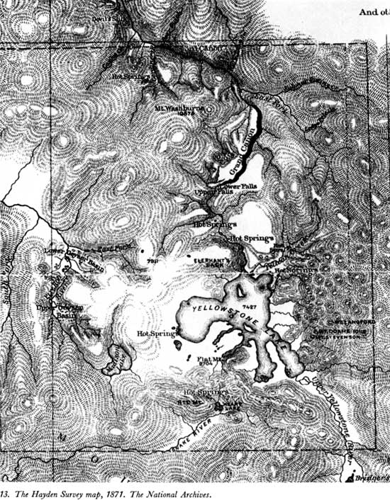
Captain Barlow's calamity was beyond remedy. The fire which leveled most of Chicago on October 8-11, 1871, also destroyed the headquarters of the Military Division of the Missouri, and with it much of the results of the expedition from which Barlow had just returned. In a letter to Hayden, he explained,
You will sympathize with me I know when I tell you that our great fire swept away all my photographic plates before prints were taken from them. Only 16 prints were made on Saturday previous to the fire, these 16 Mr. Hine had taken to his house & saved. I lost some of my notes also, though my journal was saved from which I can make a report. The map notes were up at St. Paul & Capt. Heap has sent me a sketch of our route. As we only partially surveyed the Lake (knowing that you were doing so with great care) I depended upon your work in that particular, & hope to receive a copy of your map very soon . . . I shall have to trust to our old friendship & your generosity, now, respecting an exchange of photographic views. I can only offer you 16 copies, instead of near 200, that I expected to have had. Not one single paper or other property was saved from my office. All my instruments, maps, books, & everything brought back from the Yellowstone, including specimens were consumed. I have had to begin all anew. [236]
Hayden was able to send 100 large prints and an equal number of stereoscopic views as samples, from which Captain Barlow was to pick the photographs he needed. It was necessary for the latter to deal directly with William H. Jackson to obtain his prints because the photographer had retained all the negatives as a condition of employment. [237] Captain Barlow desired the photographs for distribution with his report, [238] and for illustrating the several articles General Sheridan urged him to write.
But General Sheridan was not alone in urging an exposé; Thomas Moran's presence with the Hayden contingent was dictated by Scribner's need for illustrative material for yet another Yellowstone article by N. P. Langford (who had been expected to accompany the 1871 expedition in the interest of J. Cooke & Co.). However, Langford was either unable or unwilling, so editor R. W. Gildess found it necessary to write Hayden at Fort Hall, admitting they were "at sea for some literary accompaniment" for Moran's sketches (he had returned to the East early). The question put to Hayden was, "Can you do it for us?" The editor wanted something within a month; if that were not possible, "could you do it for us when you get back to Washington?" [239] It had to be the latter, and it was published in time to be very helpful in bringing the effort to establish Yellowstone Park to a successful conclusion.
The 1871 exploration received an immediate and enthusiastic notice in the press. As the Helena Daily Herald said, "The results of the observations and examinations of the late scientific expedition, will soon be given to the public by press, and through it excite a curiosity and interest, which the wonders of Vesuvius, Niagara, and the geysers of Iceland, have never yet caused to be felt." [240] Less than a week later the New York Times, while anticipating "trustworthy, exact, and comprehensive . . . information of one of the most wonderful tracts of the American continent," stated:
There is someting romantic in the thought that, in spite of the restless activity of our people, and the almost fabulous rapidity of their increase, vast tracts of the national domain yet remain unexplored. As little is known of these regions as of the topography of the sources of the Nile or the interior of Australia. They are enveloped in a certain mystery, and their attractions to the adventurous are constantly enhanced by remarkable discoveries. . . . Sometimes, as in the case of the Yellowstone Valley, the natural phenomena are so unusual, so startlingly different from any known elsewhere, that the interest and curiosity excited are not less universal and decided. [241]
Something of the persistent skepticism with which information concerning the Yellowstone region was received is evident in an item subsequently published in the same columns. Under the title, "The New Wonderland" (probably the first published use of the term "wonderland" to typify what is now the park), the Times made the following comment in regard to the information received from the expedition's artist, Henry Elliot:
The accounts of the Yellowstone country hitherto received, even when brought by authorities so respectable as Lieut. Doane, have been so extraordinary that confirmatory testimony has been anxiously looked for. Even now, and with every respect for the new witness, part of whose evidence we shall quote, the official narrative of the Hayden Expedition must be deemed needful before we can altogether accept stories of wonder hardly short of fairy tales in the astounding phenomena they describe. [242]
But regardless of the lingering skepticism, the information obtained in 1871 was reaching the reading public from one side of the Nation to the other. Comments and narratives stemming from expedition personnel appeared in the Boston Advertiser (Massachusetts), the Cleveland Herald (Ohio), the Omaha Herald (Nebraska), and the Sacramento Bee (California). Leslie's Illustrated for September 31, 1871, carried an article by Henry Elliot—spoken of as "our artist." [243]
However not all the publicity generated at this time originated with the Hayden and Barlow parties. Truman C. Everts' article in Scribner's Monthly (November, 1871) was a holdover from the expedition of 1870 [244] and a series of articles which appeared in the Deer Lodge New North-West (Montana) resulted from a visit by a party that entered the Yellowstone region from the west in August. [245] This group, which included U.S. Mining Commissioner R. W. Raymond; his assistant, a Mr. Eiler; A. F. Thrasher, a Virginia City photographer; J. S. Daugherty, an Indiana business man traveling for his health; C. C. Clawson, a reporter and author of the "Notes," and Gilman Sawtell, settler at Henry's Lake and guide, were the vanguard of that tourism which, a century later, swelled to more than 2 million persons annually.
There were other signs of the end of the period of definitive exploration, among them the appearance of settlers within the Yellowstone region. The Hayden and Barlow parties found intrusions at three points. On Gardner River, near the great outflow of hot water that had caused the prospectors to name it "Warm-Stream Creek," they found a haphazard encampment of invalids who called their rude spa "Chestnutville"—a place Matthew McGuirk claimed that fall and developed into "McGuirk's Medicinal Springs." [246] Upon the hot spring terraces then generally known as "Soda Mountain," two Bozeman men had laid claim to the hot springs and built a cabin. [247] They were Harry Horr, the same who had accompanied the springwagon sent up to Yankee Jim Canyon to convey the rescued Truman C. Everts out of the wilderness, and James C. McCartney. Jack Baronett, whose rescue of Everts had gained him nothing but the inspiration to build a toll bridge over the Yellowstone River on the road to the new mines on Clark Fork (the present Cooke City area), had control of a site at the mouth of Lamar River. His was the first bridge to span the Yellowstone River at any point. [248]
One of the men bathing at "Chestnutville" (Hot River) when Hayden and Barlow arrived was A. Bart Henderson, whose diary entry for July 24, 1871, notes:
Left camp at 9 o'clock & followed down the river. Arrived at Bottlers Ranch. Here I remained a few days, resting and viewing out a road which I located on the 12 day of Aug. 1871. It is to run from Bozeman to the Yellowstone Lake, by the Mammoth Hot Springs, built for the benefit of the travel to & from Wonderland, & to be a toll road. I soon commenced work on the same . . . [249]
Even before the explorers of 1871 turned homeward with their notes and specimens, the process of subduing the Yellowstone wilderness had been begun in the style of the American frontier—by raising cabins and building roads within its fastnesses, and surely it would have gone the way of many another pristine locality except for a letter that came to Dr. Hayden in the City of Washington.
|
|
Last Modified: Tues, Jul 4 2000 07:08:48 am PDT
haines/part2.htm