|
Cuyahoga Valley National Park Ohio |
|
 NPS photo | |
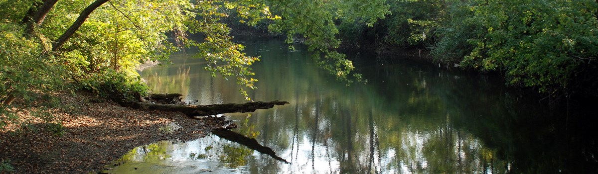
Along the Crooked River
Before the Cuyahoga River empties into Lake Erie in downtown Cleveland, it snakes through a green, welcoming valley. People have relied on the river for thousands of years. The lower Cuyahoga was part of early transportation networks. Later it powered industry and grew cities. It became infamous for its pollution, rallying the nation. Today a cleaner Cuyahoga River shows us how nature's renewal benefits the entire metropolitan area.
Cuyahoga Valley National Park protects the river between Akron and Cleveland. It is a patchwork of natural areas, villages, and small farms. Families stroll after dinner along the canal towpath. Water lilies part as a lone beaver swims across a marsh. Valley slopes teem with skiers and sledders in winter. Uplands offer forests, rock ledges, and waterfalls to inspire the spirit.
BOSTON HEART OF THE PARK Villages like Boston developed along the Ohio & Erie Canal in the early 1800s. By mid-century, Boston had boat yards, a lumber mill, a brickyard, and a warehouse.
Canal transport became obsolete in the 1880s, when the railroad arrived. Along tracks laid on the west side of the river. Valley Railway moved farm produce and goods faster, and at less cost.
One of the newer businesses built beside the tracks made roofing paper and paper sacks to hold flour. The factory's former company store is now Boston Mill Visitor Center. Here rangers and volunteers can help you plan a visit to suit your interests, time, and needs. The river, train, canal towpath, and scenic byway are only steps away.
SCENIC VIEWS Cuyahoga Valley has a long history as a place where people from Cleveland and Akron connect with nature. In the 1920s, community leaders established Bedford Reservation, which included Tinkers Creek Gorge, to protect upland scenery. Its deciduous forest offers spectacular color in fall.
RENEWAL In 1969 the Cuyahoga River fire in Cleveland focused national attention on water pollution. The fire led to environmental activism, new laws, and the realization that protecting water is a shared responsibility.
When water recovers, wildlife recovers. In 2007 a pair of bald eagles nesting near Station Road Bridge raised the first chick ever recorded in the valley. Visit the park to see people and nature working together.
WATERFALLS Visit the park's many falls in any season. Water tumbles over rocks formed when inland seas covered the continent. Delicate plant communities grow in these moist, cool areas. Brandywine Falls is near the remains of a lost village.
TRANSPORTATION Native Americans who canoed the lower Cuyahoga River found that it offered a favorable portage between the Great Lakes and the Mississippi River. In the 1700s European fur traders set up temporary trading posts along the lower river, where they exchanged cloth, metal, and guns for pelts.
In the early 1800s engineers diverted water from the lower Cuyahoga River for a canal that, for a few decades, was an important link in an inland shipping network.
The Ohio & Erie Canal connected heartland farms to East Coast ports, launched Cleveland and Akron as major cities, and helped build a national trade economy. Today the park preserves and adapts the Cuyahoga Valley's historic canal, and the railroad that supplanted it, for recreation.
PARKS TO THE PEOPLE Visitors from nearby cities took leisure rides to Cuyahoga Valley via the canal and railway. The Civilian Conservation Corps (CCC) and Works Progress Administration (WPA) built picnic shelters, lakes, play fields, and parking lots during the Depression. Ledges and Kendall Lake have examples. In the 1950s new roads and highways made possible larger-scale attractions like Blossom Music Center. Congress established Cuyahoga Valley National Park in 1974 as part of Parks to the People, a civil rights initiative to create national parks in metropolitan areas.
YOUTH OUTDOORS Three scout camps and Camp Mueller, run by the Phillis Wheatley Association (known as the "Black YWCA"), began in the 1930s. The park's overnight environmental education center serves schools and other groups. For student safety, these sites are closed to the public.
AGRICULTURE Native Americans farmed maize, beans, and squash here. Jonathan and Mercy Hale were among the first European American farmers in the valley. Experience their legacy at Hale Farm & Village, a living history museum. Countryside operates farmers' markets year-round and assists with park-leased farms.
WILDLIFE RETURNS Beavers were absent from Ohio for a century, but they began to return in numbers in the 1970s. They flooded a former auto salvage yard and created a marsh. Great blue herons and otters have also re-established, thanks to more wetlands and a cleaner river.
Visit the Valley
Experience nature, discover history, and pursue recreation in Cuyahoga Valley National Park. Four arteries—automobile byway, canal towpath, scenic railroad, and river—extend north and south. Country roads and trails branch east and west toward ravines, falls, forests, lakes, and farmsteads.
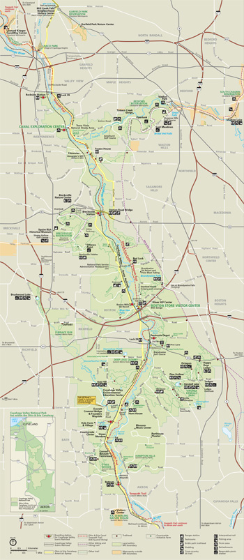 (click for larger map) |
Start at the heart of the park
Boston Mill Visitor Center is open daily, with hours that vary
seasonally. Rangers, volunteers, and exhibits can answer questions and
help orient you. If you arrive before or after hours, see the exhibits
in the courtyard.
The train drops passengers off at the station by the main parking lot. Cross the river (east) to reach the canal towpath and see the village of Boston. Find snacks and lunch at Trail Mix (store open seasonally). Relax at a shady table as you plan your time in the park.
ROAD
Ohio & Erie Canalway Byway Attend lock demonstrations in summer at
the Canal Exploration Center, a short drive north. Follow the byway
signs.
TRAIL
Ohio & Erie Canal Towpath Trail The popular trail is firm and flat.
Mules once walked here as they towed heavy boats.
RAIL
Cuyahoga Valley Scenic Railroad A scenic excursion ticket allows you to
hop on and off the train. Kayakers, cyclists, and through hikers can use
the seasonal one-way shuttle service.
RIVER
Cuyahoga River If you're a skilled paddler you can experience the
valley from your kayak or canoe. Travel through the national park on the
Cuyahoga River Water Trail at your own risk. Check cuyahogariverwatertrail.org first for important
safety information and current access points.
Soon after civic leaders in Cleveland and Akron created Ohio's first two county park systems, they acquired land in Cuyahoga Valley. The first parks in the valley were established in the 1920s. As development pressures grew, advocates called for federal protection. Success came in 1974 when Congress designated the national park.
Landscape Upland streams carve steep ravines into the valley's forested slopes. In the floodplain, the river winds with relative freedom for 20 miles, past natural features, small villages, and historic farmsteads. Restoring natural flow is vital to healthy waterways.
Wildlife Great blue herons gather in nesting colonies along Bath Road. Bald eagles soar above Station Road Bridge. Muskrats, beavers, and otters swim in Beaver Marsh. Turtles and snakes bask on logs in the canal.
Preservation Dive into local history. Some buildings represent the canal era of the early to mid-1800s. Mills, play fields, trails, lakes, camps, and an education center are the legacies of industry, philanthropy, and Depression-era federal programs.
Lodging and Events Spend the night at a historic house in the park, or camp at a state or county park. Visit forcvnp.org/lodging. To reserve a picnic shelter for your group, visit recreation.gov. Permits are required for weddings, special events, commercial photography, and filming. Use the "reserve" button at www.nps.gov/cuva.
Things to Do Pick up a free quarterly Valley Guide at the visitor center for a list of programs at over 50 locations within the park. Choose from leisurely or fast-paced ranger-led hikes, workshops, concerts, and other programs for all ages. The park has many trails, some open to horses and mountain bikes. Leashed pets are allowed on most trails.
National Heritage Area The park is part of the Ohio & Erie Canalway National Heritage Area. For information visit ohioanderiecanalway.com.
Partners Conservancy for Cuyahoga Valley National Park, Countryside, and Cuyahoga Valley Scenic Railroad
Accessibility We strive to make our facilities, services, and programs accessible to all. For information go to a visitor center, check the Valley Guide, visit our website, ask a ranger, or call.
Source: NPS Brochure (2019)
|
Establishment
Cuyahoga Valley National Park — October 11, 2000 |
For More Information Please Visit The  OFFICIAL NPS WEBSITE |
Documents
A Green Shrouded Miracle: The Administrative History of Cuyahoga Valley National Recreation Area (Ron Cockrell, 1992)
Archeological Investigations at Site 33SU121, Cuyahoga Valley National Park, Summit County, Ohio Midwest Archeological Center Technical Report Series No. 127 (Ann C. Bauermeister, 2010)
Archeological Investigations at The Savacoal Property In Boston Village, Cuyahoga Valley National Park, Summit County, Ohio Midwest Archeological Center Technical Report Series No. 128 (Ann C. Bauermeister, 2011)
Bedrock Geologic Map of Cuyahoga Valley National Park, Ohio (2020)
Compendium of the Oral History Project for the Cuyahoga Valley Administrative History (Ron Cockrell, 1991)
Cultural Landscape Report, Cuyahoga Valley National Recreation Area (Chester Hamilton, Edward Adelman and Steve Elkinton, December 1987)
Cultural Landscapes Inventory: Edmund Gleason Farm, Cuyahoga Valley National Park (March 2013)
Cultural Landscapes Inventory: Welon Farm (112-65), Cuyahoga Valley National Park (2012)
Deer Management in Cuyahoga Valley National Park: A Study of Local Residents' Attitudes Final Report (Erin M. Dougherty, David C. Fulton and David W. Lime, May 2001)
Foundation Document, Cuyahoga Valley National Park, Ohio (July 2013)
Foundation Document Overview, Cuyahoga Valley National Park, Ohio (July 2013)
Geologic Map of Cuyahoga Valley National Park, Ohio: Glacial (2020)
Geological Resources Inventory Report, Cuyahoga Valley National Park NPS Natural Resource Report NPS/NRSS/GRD/NRR-2020/2154 (Trista L. Thornberry-Ehrlich, July 2020)
Historic Structure Report: Ohio and Erie Canal, Cuyahoga Valley National Recreation Area, Ohio (Harlan Unrau and Nick Scrattish, August 1984)
Junior Ranger Handbook (Ages 7-12), Cuyahoga Valley National Park (Date Unknown; for reference purposes only)
Microbiological Water Quality in Relation to Water-Contact Recreation, Cuyahoga River, Cuyahoga Valley National Park, Ohio, 2000 and 2002 USGS Professional Paper 2003-4333 (Rebecca N. Bushon and G.F. Koltun, 2004)
National Register of Historic Places Nomination Forms
Abraham Ulyatt House (Carol Poh Miller, June 8, 1978)
Albert Cofta Farmstead (c2004)
Allen Welton House (Carol Poh Miller, June 5, 1978)
Barker Village Site (33-Su-32) (David R. Bush, November 12, 1975)
Boston Mills Historic District (Norma J. Stefanik and Jeff Winstel, November 1991)
The Botzum Farm (Jeff Winstel, April 1999)
Brown/Bender Farm ("Jim" Brown House Boundary Increase) (Jeff Winstel and Dean Dickerson, October 1989 and May 1992)
"Jim" Brown House (Carol Poh Miller, May 30, 1978)
Camp Chase Site (William H. Carlile, July 10, 1972)
Camp Manatoc Concord Lodge and Adirondacks Historic District (Gina Jeckering, June 1995)
Camp Manatoc Dining Hall (Jeffrey Winstel, June 1995)
Camp Manatoc Foresters Lodge and Kit Carson/Dan Boone Cabins Historic District (Jeffrey Winstel, June 1995)
Camp Manatoc Legion Lodge (Jeffrey Winstel, June 1995)
Charles B. Rich House (Carol Poh Miller, May 1, 1978)
Daniel Tilden House (Chester V. Hamilton and Edward H. Adelman, February 13, 1984, revised June 4, 1985)
Edmund Gleason Farm (boundary increase) (Jeff Winstel and Dean Dickerson, June 1989 and May 1992)
Edmund Gleason House (Carol Poh Miller, June 1, 1978)
Edward Cranz Farm (Jeff Winstel, Paulette Oswick and Melinda Campbell, May 1992, April 1990, August 1987)
Everett Historic District (Jeff Winstel, October 1992)
Everett Knoll Complex (33-Su-14) (David R. Bush, August 21, 1975)
George Stanford Farm (Carol Poh Miller, January 5, 1981)
Hunt/Wilke Farm (Jeff Winstel, Paulette Oswick and Melinda Campbell, May 1992)
Jaite Mill Historic District (Carol Poh Miller, August 28, 1978)
Jonas Coonrad House (Carol Poh Miller, May 8, 1978)
Jonathan Hale Homestead (Charles D. Willits, December 30, 1971)
Jyrovat Farmstead (Theresa Larkin, April 1994)
H. Karl Butler Memorial (Gina Jeckering, September 1994)
Lutz/Martin Farm (Sam Tamburro, April 2002, revised February 2003)
Michael Duffy Farm (Melinda Campbell, Paulette Oswick and Jeff Winsel, August 1987, April 1990 and May 1992)
Nathaniel Point Farm (Sam Tamburro, October 1998)
Ohio and Erie Canal Deep Lock (Eric Johannesen, October 1973)
Ohio and Erie Canal (Joseph S. Mendinghall, February 28, 1975)
Packard-Doubler House (Carol Poh Miller, June 12, 1978)
Peninsula Village Historic District (Eric Johannesen, November 1973)
Recreation and Conservation Resources of Cuyahoga Valley, 1870-1945 (Jeff Winstel and Kurt Mulhauser, October 3, 1994)
Richard Vaughn Farm (Jeff Winstel, April 13, 1992)
Russ and Holland Snow Houses (Carol Poh Miller, January 29, 1981)
South Park Site (33-Cu-8) (David R. Bush, September 8, 1975)
Station Road Bridge (Carol Poh Miller, April 26, 1978)
Stebbens Farm (Jeff Winstel, April 15, 1992)
Stephen Frazee House (John Hynton House) (Eric Johannesen, July 1975)
Terra Vista Archeological District (33-Cu-17 and 33-Cu-18) (David R. Bush, November 12, 1975)
Vaughn Site (33CU65 (Cathie Masters and Richard Rogers, April 6, 1987)
Virginia Kendall State Park Historic District (Jeffrey Winstel, June 1995)
Wallace Farm (Chester V. Hamilton, February 23, 1984)
William Burt House (Carol Poh Miller, May 23, 1978)
William and Eugene Cranz Farm (Jeff Winstel and Melinda A. Campbell, August 1987 and May 1992)
William H. Knapp House (Carol Poh Miller, May 8, 1978)
Natural Resource Condition Assessment Cuyahoga Valley National Park NPS Natural Resource Report NPS/CUVA/NRR—2021/2243 (David S. Jones, Roy Cook, John Sovell, Matt Ley, Hannah Pilkington, David Weinzimmer, Pamela Smith and Carlos Linares, March 2021)
Ohio and Erie Canal History and Historic Structure Assessment (Heberling Associates, Inc., June 2019)
Ohio Historical Inventory
"Jim" Brown Tavern (Carol Poh Miller, May 1976)
Furnace Run Aqueduct (Carol Poh Miller, April 1976)
Lock No. 26 (Pancake Lock) (Carol Poh Miller, April 1976)
Lock No. 27 (Johnny Cake Lock) (Carol Poh Miller, March 1976)
Lock No. 28 (Deep Lock) (Carol Poh Miller, March 1976)
Lock No. 29 (Peninsula Lock) and Aqueduct (Carol Poh Miller, April 1976)
Lock No. 30 and Feeder Dam (Carol Poh Miller, March 1976)
Lock No. 31 (Lonesome Lock) (Carol Poh Miller, March 1976)
Lock No. 32 (Carol Poh Miller, April 1976)
Lock No. 33 (Lost Lock) (Carol Poh Miller, April 1976)
Lock No. 34 (Red Lock) (Carol Poh Miller, April 1976)
Lock No. 35 (Carol Poh Miller, March 1976)
Lock No. 38 (12 Mile Lock) and Spillway (Carol Poh Miller, March 1976)
Paleontological Resource Inventory (Public Version), Cuyahoga Valley National Park NPS Science Report NPS/SR-2024/210 (Austin B. Shaffer, Vincent L. Santucci, Justin S. Tweet and John-Paul M. Hodnett, November 2024)
Park Newspaper (The Valley Guide): Winter/Spring 2021
Park Newspaper (The Valley Observer: A Guide to Cuyahoga Valley Scenic Railroad): Date Unknown
Social Conflict at Virginia-Kendall Park, Cuyahoga Valley National Recreation Area CPSU/UI S-81-3 (Gary E. Machlis, Richard S. Converse and Eric L. Jensen, 1981)
Surficial Geologic Map of Cuyahoga Valley National Park, Ohio (2020)
The Ohio & Erie Canal: The Evolution of a Name, 1825-1996 (Sam Tamburro, June 17, 2002)
The Tree with Many Names (Becky MacKay and Ryan Trimbath, September 18, 2020; updated June 9, 2021)
cuva/index.htm
Last Updated: 01-Jan-2025