|
EBEY'S LANDING
Ebey's Landing National Historical Reserve Reading the Cultural Landscape |

|
PRESERVATION PRINCIPLES
Introduction
The total cultural landscape of the reserve has been growing and changing as community needs and values shift over generations. Preservation principles are not intended to inhibit or stop growth, but serve as guides for understanding how much change and what kinds of change can occur before the cultural context and historic integrity of the landscape is lost.
This report has outlined historic settlement patterns, land uses, and resulting structures. It has identified natural and cultural resources in the landscape today and illustrated ways to describe critical landscape relationships among these individual resources. The preservation principles that follow are based on that information and patterned in the following manner.
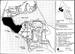
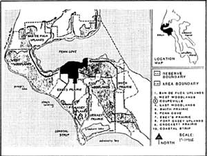
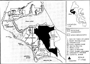
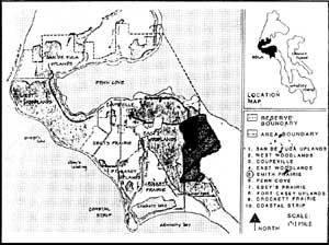
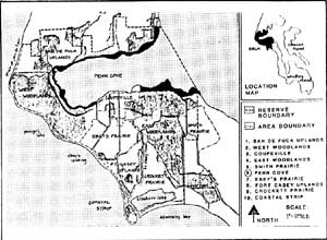
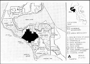
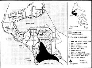
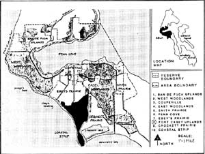
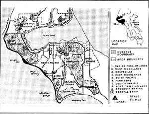
First, while the reserve as a whole is considered a single landscape, within it are ten distinct land units or character areas that can be used as a framework for evaluation and development of preservation principles. These ten areas are identified in the 1983 Building and Landscape Inventory and include all eighteen sites listed in the Comprehensive Plan (1980). The ten areas include: the San de Fuca Uplands, West Woodlands, Coupeville, East Woodlands, Smith Prairie, Penn Cove, Ebey's Prairie, Fort Casey Uplands, Crockett Prairie, and the Coastal Strip.

For each of the ten land areas an evaluation of landscape resources includes:
a description, including location and boundaries, general character and primary access;
a statement summarizing the historic patterns and significant elements that remain and contribute to an overall landscape integrity;
a set of principles to guide preservation of significant historic landscape patterns, features and structures as identified in this report and the 1983 Building and Landscape Inventory.
It is important to note that the landscape evaluation and the principles outlined in this report address preservation of the general landscape patterns that are historically significant. Guidelines for preservation of more discrete or site specific land units would require a more detailed evaluation.
Finally, in several of the preservation principles, reference is made to the visual quality or visual resource of a character area. A short discussion of these resources is included in the appendix and techniques for visual assessment can be found in the bibliography.
San de Fuca Uplands
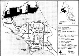
Location and Access
Located along the northernmost portion of the reserve, the San de Fuca Uplands are bounded by Penn Cove to the south and east, the Coastal Strip along the west and the reserve boundary on the north.
San de Fuca is characterized by the sweep of land up from Penn Cove which levels out to agricultural land broken by woodlots and residential subdivisions Primary access is along Highway 20, which slices through from north to south, and Scenic Heights Road which follows Penn Cove around the edge of the uplands.
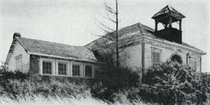
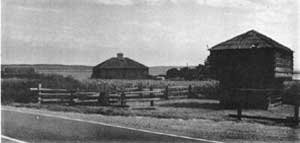
Old San de Fuca School (1903) on Zylstra Road.
Significance and Integrity
Archeological evidence suggests the Skagit Indians used portions of the upland areas bordering Penn Cove for cultivating and harvesting camus, fern and nettle.
White settlement began in 1850 when ten donation land claims were made in the uplands. Early land use patterns focused around the natural harbor of Penn Cove, and development of agriculture on the uplands. Although good soils existed in the uplands, large portions of the area were densely-wooded and many settlers turned their lands into less intensive agricultural crops and pasture areas. These patterns remain in several areas and are evidenced in a number of small cultivated lots and pasture lands between woodland stands.
Associated with the period of community development on the reserve, the town of San de Fuca was platted in the 1880s. Although the town did not survive into the twentieth century, the name did, and several of the seventeen historically significant buildings in the uplands are located in and around the town site.
Although several areas of the San de Fuca Uplands are still in agriculture, three newer residential subdivisions have significantly altered historic land use patterns and limited overall historic landscape integrity.
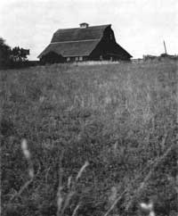
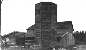
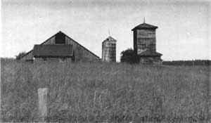
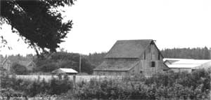
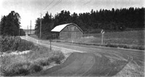
This barn (1918) is part of the Arnold farm complex
overlooking Penn Cove in San de Fuca.
Preservation Principles
Preservation principles for the San de Fuca Uplands encourage protection and maintenance of remaining significant and historic landscape patterns and features.
In order to preserve historic landscape patterns and visual quality in the uplands, maintain existing rural residential-agriculture land use designations and all significant historic structures.
Limit further intrusions on agricultural land by encouraging new residential development to occur within existing subdivisions.
In order to support visual quality in the area, any new structures should be carefully sited along the edges of open areas and sensitive in design, scale, mass, color and material to surrounding areas (see Design Considerations for Historic Properties, 1984).
Maintain existing hedgerows throughout the area as natural and cultural resources.
West Woodlands
Location and Access
The West Woodlands are located in the narrow neck of Whidbey Island, with the Coastal Strip forming the west boundary, Penn Cove on the east, San de Fuca Uplands on the north and Ebey's Prairie along the south.
The area is topographically diverse with the highest ridges on the reserve and the largest depressions, called kettles in excess of 200 feet. The forest cover is primarily second and third-growth Douglas Fir, western red cedar with alder, salal and rhododendron understory.
Primary access is limited to Highway 20 and a foot trail along the bluff.
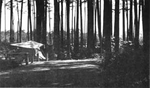
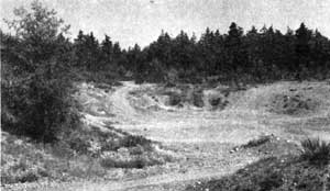
Camping area in Fort Ebey State Park.
Significance and Integrity
Densely-wooded and remote, this area remains a significant natural resource, reflecting the geological history of the reserve. The kettles, formed as huge chunks of ice melted, are unique on the island. Lake Pondilla in Fort Ebey State Park fills such a kettle hole.
From earliest human occupation, the inaccessible nature of the forest forced major settlement around the ridge or along its edges. Land speculators and logging interests eventually capitalized on the resource and by 1900 the forest had been cut at least once. However the forest has grown back and although some development is occurring in the interior portions including residential development and gravel extraction, the area as a whole remains a significant natural resource area.
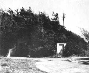
Remains of gun emplacements located on the west shoreline in Fort Ebey State Park.
Preservation Principles
Preservation principles for the West Woodlands focus on maintaining the natural resources of the area.
In order to protect the existing natural quality of the area, maintain forest-park land use designation for entire area.
Large residential developments within the woodlands are discouraged. However, where new development occurs, appropriate vegetative screening and the clustering of structures is strongly encouraged in order to minimize potential impacts on natural resources.
To maintain the visual quality of the woodlands, the wooded edges of the ridge must be maintained as visual buffers to the interior, especially along Ebey's Prairie, Highway 20, and the Coastal Strip.
Coupeville
Location and Access
The town of Coupeville is the commercial center of the reserve, occupying 740 acres of land stretching across Highway 20 to Prairie Center in Ebey's Prairie. Coupeville is bounded by Penn Cove on the north, Woodlands to the east and west, and Ebey's Prairie on the south.
Primary access into the town is along Main Street off of Highway 20, along Parker Road from the east , and Madrona Way from the west.
Significance and Integrity
Platted in 1881, the town of Coupeville grew quickly into the market and service center of the island. Front Street, along the waterfront, was the original center of town and still contains the oldest commercial buildings in Coupeville, including a number of false-front structures from the nineteenth century.
Neighborhoods surrounding the old commercial core also contain several older residences, many of which retain qualities from their original site designs. These designs include large, undivided lots, remnant orchards, gates, walls, walks and grounds that denote early patterns and development trends, as well as social values.
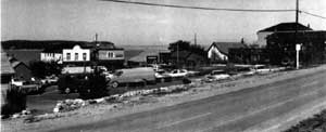
Prairie Center, in the southernmost portion of the city (south of Highway 20), developed as the military base at Fort Casey grew and centered around Pat's Place (now the Tyee Motel and Cafe) built in 1910.
Contemporary activities associated with tourism and recreation, including boating on Penn Cove and the dock at Coupeville's wharf, echo historic trends that lend regional importance to the town.
 |
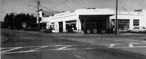 The Olympic building and the Tyee Motel and Cafe in Prairie Center. |
The Wharf in Coupeville, historically a major access
point for the movement of goods, now provides moorage for small boats.
Preservation Principles
Preservation principles for Coupeville encourage the continued maintenance of all historic structures and significant landscape patterns and features.
In order to preserve historic landscape patterns, maintain distinct and separate commercial districts and residential neighborhoods.
In order to maintain visual continuity and quality any new buildings in the area should be sympathetic in design, scale and material to surrounding structures, land forms, and views especially to the water (see Design Considerations for Historic Properties, 1984).
Maintain the cohesive visual and material quality of the town by encouraging attention to entry experiences, signage, building setback and scale, orientation of structures to each other and surroundings, and a general regard for the townscape as a whole.
East Woodlands
Location and Access
The East Woodlands are located along a ridge line on the eastern portion of the reserve. Smith Prairie and Keystone Road form the eastern boundary, Crockett Prairie, the southern edge; Ebey's Prairie and Coupeville, the western edge; and Penn Cove, the northern boundary
This area, like the West Woodlands, is largely remote and undeveloped with some residential development and Rhododendron Park located within.
Primary access is along Highway 20, which slices through the center of the woodlands, and Parker Road which follows the northern edge.
Significance and Integrity
Densely-wooded, this area remains a natural resource area. The inaccessible nature of the forest channeled early settlement around the large ridge into the prairies and along its edges.
More recent development, including scattered residential structures and recreational activities associated with park areas, have maintained the forest edge as a visual screen, and, as a whole, the area maintains its natural resources.
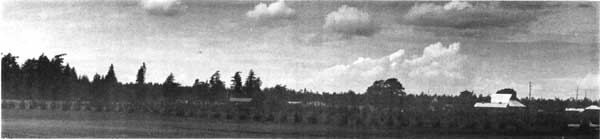
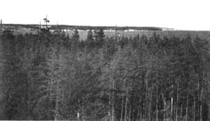 Views from the east woodlands looking north across Penn Cove. |
 Cleared area within woodlands is not visible from the road because of vegetation left along edges as physical screen. |
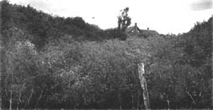
A complex in the interior portion of the woodlands
Preservation Principles
Preservation principles for the East Woodlands focus on maintaining the natural resources of the area.
In order to protect the remaining natural quality of the area, maintain forest land use designation for entire area.
Large residential developments within the woodlands are discouraged. However, where new development occurs, appropriate vegetative screening and the clustering of structures is strongly encouraged in order to minimize potential impacts on natural resources.
To maintain the visual quality of the woodlands, preserve wooded edges of the area as a visual buffer, especially as viewed from Highway 20 and Parker Road.
Smith Prairie
Location and Access
Divided by the reserve boundary, most of Smith Prairie is located outside the reserve. The small portion that is within the reserve is bounded on the west by the forest of the East Woodlands.
A 600-acre open area enclosed by forest, Smith Prairie is the primary south entry to the reserve. Access is along Highway 20, which cuts across the prairie.
Significance and Integrity
The early donation claims of Joseph Smith and John Kineth filled the small portion of the prairie land inside the reserve. One of the first roads on the reserve (1854) linked Ebey's claim and Smith's claim. The Kineth farm complex, located along the old wagon road from Coupeville to Langley, is in its original location with a number of original outbuildings remaining on the complex. The land itself, while used for agriculture, was never as productive as the other prairies, and as a result, less intensive pasture and grazing replaced market crop production. That pattern continues today and a variety agricultural land uses remain, including a tree farm, state game farm, feed crops, some pasture and natural open areas.
The presence of these land uses and the remaining farm complex reflects a continuity of land use that contributes to the historic integrity of the landscape.
Preservation Principles
Preservation principles for Smith Prairie focus on maintaining its naturally open and historically rural character.
In order to maintain the open nature and overall visual qualities of the prairie, maintain existing agricultural land use designation and existing historic structures.
In order to minimize other potential visual impacts on the prairie, any new structures not associated with existing complexes should be located along the edges of the prairie.
To support the historic and natural "low profile" of the prairie landscape, development of hedgerows along existing fence lines or in lieu of new fence materials is encouraged.
View of Smith Prairie looking northwest from Highway
20. Tree farm is in the foreground.
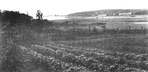
Penn Cove
Location and Access
The Penn Cove area includes the 4,000 acres of water that constitute the cove itself and the ten miles of shoreline along its edge.
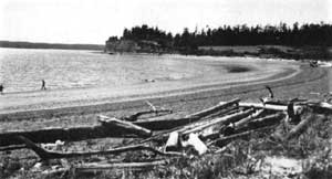
Exhibiting a distinct beach character the shoreline varies from high sandy cliffs to muddy tidelands, with points of land extending into the cove.
Primary access is along a series of shoreline roads which circle the cove including Parker Road, Front Street in Coupeville, Madrona Way and Scenic Heights Road.
Significance and Integrity
Occupied and used by Indians and white settlers for nearly 600 years, the lands surrounding Penn Cove are richly layered with cultural history.
The oldest known significant resources are the 34 archeological sites, including three permanent Salish villages.
White settlers also realized the value of the water resource and eleven original donation land claims were taken up along the shores of the cove.
The first trading post on the entire island located along the shores of Penn Cove on Captain Barstow's claim. An overland road, developed in 1854, linked the cove and Ebey's Prairie following portions of what is now Madrona Way.
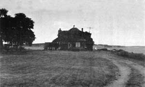
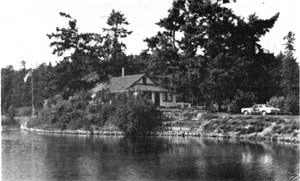
Nearby, and associated with the period of early settlement, the county seat was established at Coveland where it remained until 1881 when Coupeville became the primary service area for the region. Also in the vicinity of Coveland, a small resort area grew around the cove at the turn of the century. The Captain Whidbey Inn (1901) was built during this time, and it, along with several small cabins, echo the subsequent historic trends in recreation and tourism around the cove.
Today, similar recreation-related activities including the development of seasonal homes, boat launches, and beach areas, reflect the use of Penn Cove as a significant natural resource and recreational area on the reserve.
Seventeen contributing and historically significant structures remain on the shores of Penn Cove. Because of these structures, the thirty-four known archeological sites, and the cove itself, Penn Cove remains a valuable cultural and natural landscape area.
 A cottage on Snakelum Point built as a summer home for Seattle residents in the 1940s. |
 Several homes are located along the shores of Kennedy's Lagoon just across the road from Penn Cove. |
Preservation Principles
Preservation principles for Penn Cove focus on the protection of significant cultural and natural resources.
In order to protect known archeological sites around Penn Cove, archeological clearance from the state should be obtained before any new. construction occurs along the cove.
Maintain all significant historic structures as well as natural areas reflecting historic settlement patterns including Monroe's Landing, San de Fuca, Captain Whidbey Inn, Good Beach, Kennedy's Lagoon, the Coupeville waterfront, Long Point and Snakelum Point.
Maintain the visual quality of the cove by encouraging appropriate design and thoughtful and sensitive siting of new structures.
Maintain Penn Cove as a recreational resource by providing clear public access to the water.
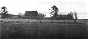
Ebey's Prairie
Location and Access
Ebey's Prairie is located in the central portion of the reserve, surrounded by the Coastal Strip on the southwest, the West Woodlands, Coupeville and Highway 20 along the north, and the East Woodlands.
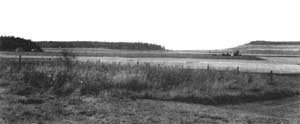
The large natural prairie is characterized by a gentle sweep of agricultural land and a patchwork of farms, fields, fences and hedgerows.
Primary access is along Highway 20, Ebey's Landing Road, Engle Road, and Hill Road.
Significance and Integrity
From the very earliest use by the Skagit Indians and subsequent settlement by white pioneers, the prairie land has been used for agriculture. Taking advantage of the open fields and fertile soils, early donation land claims by the Ebeys, Engles, Hills and others solidified settlement patterns on the prairie. Many of these claims remain remarkably intact today.
Early homes from this initial period of settlement are still standing in their original location (including the Jacob Ebey Saltbox, 1855), and are historically significant structures on the reserve. Other structures, including the cemetery, several barns and outbuildings, roads, and fencelines have remained the same for over a hundred years and reflect this same period of early settlement. Taken altogether, the stability and continuity of these broad patterns of settlement and land use, circulation, and structures, reflect a high degree of both natural landscape integrity and the history of a still-vital community.
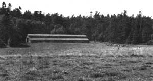
 |
 |
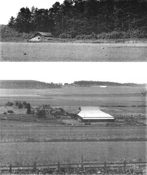
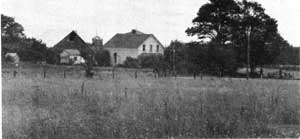
The sheep barn on the bluff overlooking the
prairie was probably part of Jacob Ebey's homestead (top, right).
The Gould house built in 1896 (bottom, right).
Preservation Principles
Preservation principles for Ebey's Prairie focus on protection of significant historic landscape patterns and features.
Protect both natural soils, historic landscape patterns and structures by maintaining an exclusive agricultural land use designation for the entire prairie.
New development or structures not associated with existing complexes should be carefully sited along the edges of the prairie (see #3 below).
In order to preserve the high degree of visual quality on the prairie, no structures, other than interpretive devices of small-scale, should be allowed on the bottom lands. Structures on the slopes should not intrude into the prairie or into the skyline when seen from local roads or viewpoints.
Maintenance and incorporation of existing fence lines and hedgerows into current land practices is strongly encouraged.
Crockett Prairie
Location and Access
A sloping triangle of land, Crockett Prairie funnels between the Fort Casey Uplands to the west, Admiralty Bay along the south, and the East Woodlands.
The prairie is a mix of both natural and cultural resources. It contains a significant natural marsh, Crockett Lake, Keystone Spit, the ferry landing, and the rich, fertile soils which cover much of the prairie.
Primary access is along Highway 20 on Keystone Spit, Wanamaker Road and Fort Casey Road.
Significance and Integrity
As one of three natural prairies on the reserve, several original donation land claims occurred here during the period of early white settlement, including five by the Crockett family alone. As was the case in other areas of the reserve, these initial claims structured historic settlement patterns and land use.
Agriculture, the dominant land use since 1850, remains viable today, due in large part to those early patterns and the excellent agricultural soils found on the prairie.
The area also retains a number of significant historic structures, including several historic buildings, barns and outbuildings, road locations, and the remains of a bridge over Crockett Lake which connected Keystone and Prairie Center in 1874.
Development of plats for the towns of Chicago and Brooklyn in the late nineteenth century coincided with the period of community growth on the reserve. Although no structures from those developments remain (reportedly only one hotel ever existed), several features and buildings from the military era remain in the landscape around the Keystone area, including the wharf and dock remnants.
Crockett Prairie is significant also for the natural resources of Crockett Lake, including the marsh vegetation, wildlife habitat, and the recreational use of the beach and waterfront along the spit.
Although newer residential development on the ridge east of the prairie and along its base has had a visual impact on the natural setting, the historic settlement patterns, historic and current land uses and significant structures still remain and contribute to an overall landscape integrity.
 Part of the Boyer farm, located on the original 1640 acre Hugh Crockett Donation Claim. |
 Crockett blockhouse and farm complex. |
View of Crockett Prairie, looking west.
Preservation Principles
Preservation principles for Crockett Prairie focus on protection of both natural and cultural resources and significant historic landscape patterns.
Protect both natural resources of soil and historic landscape patterns by maintaining agricultural land use designation.
New development or structures not associated with existing complexes should be carefully sited along edges of the prairie or within existing subdivisions.
In order to protect the visual quality and historic patterns in the prairie, small scale elements such as fence lines, hedgerows, and the bridge remains over Crocket Lake should be retained.
Fort Casey Uplands
Location and Access
The Fort Casey Uplands extend north from Admiralty Head between Ebey's and Crockett prairies. The Coastal Strip forms the southwest boundary.
The uplands are a mix of second-growth forests and scattered clearings of pasture or croplands.
Primary access is along Engle Road which cuts through the center of the area, Fort Casey Road along the east edge and Hill Road along the north.
Significance and Integrity
Five original donation land claims were taken in this upland area. Scattered throughout and tucked along edges of clearings are several historic buildings, barns, roads and other structures surviving from the period of early settlement. There are twelve contributing structures in the uplands including the complexes associated with Fort Casey and the military presence on the reserve over a fifty year period. Thirty buildings and structures from the military complex including gun emplacements, a light house (1901), barracks, officers' quarters, storage buildings, roads, paths, and stairways into empty fields remain in the contemporary landscape. As a whole, the remains of the complex are relatively intact, with portions under the jurisdiction of the state (Fort Casey State Park) and Seattle Pacific University (Camp Casey).
Open areas throughout the uplands are maintained to a large degree in agricultural use as they have been for a hundred years. With soils not as profitable as other areas on the reserve, smaller pastures and cropland areas developed between woodland stands and this structure influenced land use patterns. Although some new residential development is occurring and some forest areas have been cut, these basic land patterns remain.
Portions of the Fort Casey Uplands reflect historic patterns of early settlement and community development with a number of significant and contributing structures remaining in the landscape. The area as a whole retains enough of these elements to have integrity.
 |
 Squash barn on Engle Road, was built with lumber from the old grade school at Prairie Center. |
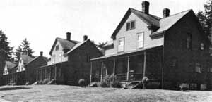
Once housing officers at Fort Casey, these historic
structures are still used as residences.
Preservation Principles
Preservation principles for the Fort Casey Uplands encourage protection and maintenance of remaining significant and historic landscape patterns and features.
In order to preserve historic landscape patterns and visual quality in the uplands, maintain the existing agricultural land use designation and all significant historic structures.
In order to support visual quality in the area, any new structures should be carefully sited along the edges of open areas and sensitive in design, scale and material to surrounding areas (see Design Considerations for Historic Properties, 1984).
Preserve and, when appropriate, incorporate into new development or interpretive features, historic remnants including old military structures, abandoned roads, and other small scale elements such as footpaths, lighting fixtures and plantings.
Coastal Strip
Location and Access
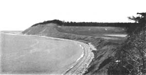
The Coastal Strip includes the beach, Peregos Lake, the shoreline and bluffs found along the eight-mile western boundary of the reserve. Elevations range from sea level to just over 200 feet. The bluffs are sparsely vegetated, relatively unstable and in a constant state of erosion.
Access to the area is limited to a state park trail, and the beach itself.
Significance and Integrity
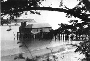
The fragile and unstable nature of the Coastal Strip has historically restricted human impacts with two significant exceptions; the landing area at Ebey's Prairie and the military emplacements associated with Fort Casey. Used over many years by the Salish Indians and early settlers, the ravine between the beach and low point along the bluff/prairie provided a natural landing and access area along the coast. Constructed in 1860 near the ravine, the Ferry house served pioneers arriving at the landing and traveling overland to Penn Cove. By 1865, a county road from the landing (and bisecting Isaac Ebey's claim) connected the shore with points north. As Penn Cove developed into a primary port area, and a ferry dock was built at Keystone, the use of Ebey's Landing area diminished. Today the Ferry house and road remain in their original locations and the landing area still serves as an access point for the state bluff trail and beach.
Military gun emplacements, including batteries, map rooms and bunkers, reflect the military presence on the reserve over a fifty-year period. Although never engaged in battle, these fortifications are significant examples of military installations during these years and remain intact. Finally, the variety of native plants and natural areas make the coastal strip a significant natural and recreational resource on the reserve.
 |
 View of Ferry house from the beach and landing area. |

Admiralty Head Lighthouse, looking north.
Preservation Principles
Preservation principles for the coastal strip focus on maintaining the natural resource of the area as a context within which significant cultural elements exist.
The Shoreline Management Plan which exists for all of Island County and protects natural resources of shoreline areas, should be observed.
Any new structures, including residential development along bluffs and interpretive structures, should be carefully sited in the natural context with sensitive regard to visual impact, materials, scale and color.
In order to protect the landing area, any regrading for vehicular circulation or construction of new access from the beach to Ebey's Prairie should be avoided. Footpaths may be appropriate if the bluff top becomes public land.
Cover | Preface | Introduction
Landscape Development and Settlement Patterns
Looking at Landscapes | Reading the Landscape | Preservation Principles
Appendix | Bibliography
rcl/rcl6.htm
Last Updated: 07-Dec-2015