|
Glen Canyon National Recreation Area Arizona-Utah |
|
 NPS photo | |
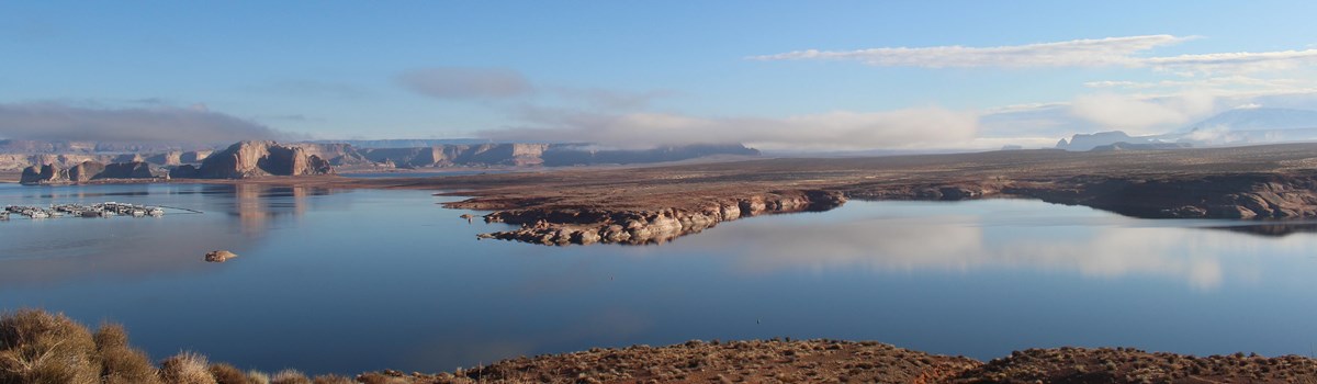
Throughout history humans have adapted their surroundings to better suit their needs. Glen Canyon National Recreation Area, established in 1972, provides a dramatic example of one of nature's most inspiring settings combined with an ambitious human project. Impounded behind the Bureau of Reclamation's Glen Canyon Dam, waters of the Colorado River and tributaries are backed up about 185 miles, forming Lake Powell. The lake and more than one million acres of desert-and-canyon country offer leisure-time activities for American and international visitors. Fishing and water sports are dominant activities. Exploring on foot can provide intimate contact with the natural and cultural features preserved here for the enjoyment of present and future generations. The Earth's forces shaped this topography, which now appears as talus slopes, buttes, mesas, canyons, and cliffs. Prehistoric human inhabitants occupied the area and left behind scattered indications of their presence.
Early Spanish explorers searching for an overland route to California left us a detailed account of their expedition. Major John Wesley Powell also chronicled the first expedition down the Colorado River. Powell named this stretch of the river Glen Canyon. Not long after his voyage, permanent settlements were established at the easiest and most reliable river crossings. An early writer about water issues and limits in this arid country, Powell was eventually honored by having the lake named for him. Born amid controversy and compromise, the dam fulfills its goals of water storage and power generation, and it provides major recreational opportunities. The resulting lake enables many people to view natural marvels and cultural features. Construction of the concrete arch dam began in 1956, and the final two generating units began providing power in 1966. The lake reached full pool level in 1980, 1983, and 1984. In 1983 and 1984 excess floodwater went over the spillways and through the diversion tunnels on each side of the dam. Lake Powell's presence in a desert landscape has modified the species of plants and animals that now inhabit Glen Canyon. Today, Lake Powell is one of the Southwest's finest lake recreation areas.
"A curious ensemble of wonderful features . . ."
—John Wesley Powell, 1869
The first human migration into North America from Asia may have occurred from 15,000 to 12,000 years ago. In small groups, these people dispersed throughout North and South America and lived in isolation for thousands of years. Tribes in this area, which we call the Desert Archaic people, were hunters and gatherers. Their continuing subsistence needs left little chance for development of higher cultural skills or for population growth. About 2,000 years ago a major cultural change—from causes about which we can only speculate—transformed these nomads into more stationary farmers, now called Basketmakers. Their weaving materials included cotton that was introduced to them by groups from the south. As they incorporated ideas from southern cultures, including above-ground houses, these Basketmaker people evolved into the culture we call Ancestral Puebloans, or Anasazi.
Exploration In 1776 two Spanish priests began an expedition that provided the first written record of Glen Canyon. Father Dominguez, Father Escalante, and their party set out from Santa Fe in July to pioneer an overland route to a military garrison on the California coast. After three months, having bypassed the canyon country, the party reached the Great Basin in Utah, where they decided to turn back before the onset of winter. On October 26, the party reached the Colorado River at the mouth of the Paria River. When crossing there proved nearly disastrous, the explorers climbed out of the river bottom and camped near today's Wahweap Marina. They spent four days searching for a way across the river. Finally, on November 7, they chopped steps into the sandstone wall at Padre Creek and safely led their pack stock to the banks of the Colorado. The Crossing of the Fathers today lies beneath Padre Bay.
Another journey of discovery began nearly 100 years after the Dominguez-Escalante expedition. Geologist John Wesley Powell set out to map the region and record its natural history. After a five-year study Powell was convinced that with careful planning the area could be settled, and his reports became the basis for reclamation in the west. In May 1869, Powell and his crew of nine men left Green River, Wyo., to follow the fabled Colorado. On July 28, they entered Glen Canyon and found its waters calm compared to the rapids of Cataract Canyon. Their trip eventually took them through the Grand Canyon and to the mouth of the Virgin River in Nevada.
Railroaders with visions of a line from Grand Junction, Colo., to the Gulf of California explored farther along the Colorado River. They declared the route feasible and said trains could be powered by electricity generated from the flow of the river; their bankers disagreed. Prospectors searched the area for riches. They discovered gold in the river's sands, but it was too fine to be mined commercially. Next came the pioneers, passing through in search of better lands. With them came the ferrymen, who were indispensable to that effort.
Settlement Although the Colorado River is accessible near the mouth of the Paria, as Dominguez and Escalante discovered it cannot be crossed easily. The Church of Jesus Christ of Latter-day Saints (Mormon Church), sent John D. Lee there to build and operate a ferry. He built the Lonely Dell Ranch for Emma Lee, his 17th wife. By 1873 Lee had built a ferryboat named the Colorado. Lee was executed in 1877 for his part in the 1857 Mountain Meadows Massacre, the attack by Mormons and Paiutes on California-bound settlers. The Mormon Church eventually bought the enterprise from Emma. The ferry ran continuously until 1928. It was replaced by the Navajo Bridge completed across Marble Canyon in 1929. Mormons colonizing the San Juan Valley created a river crossing at Hole-in-the-Rock, below the confluence of the Colorado and Escalante rivers. These pioneers blasted and fabricated a road 0.75 mile long that descended nearly 1,000 feet. Charles Hall later found a better crossing about 35 miles upstream. He ferried travelers at Halls Crossing until Cass Hite developed a more accessible crossing. The ferry and the town of Hite were active until flooded by the waters of Lake Powell.
Nature's Bold Work
Geology The spectacular landscape dominating this canyon country is the product of eons of geologic activity: shifting of continents, global rising and falling of sea levels, and creation of highlands now worn and redeposited. At times, desert dominated the landscape; sometimes, freshwater or saltwater seas invaded, leaving rivers to erode the most recently deposited layers. Prevailing winds abetted the process. Periods of erosion account for the missing rock strata and layers appearing elsewhere in sequence. The last uplift of the Colorado Plateau began about 10 million years ago. Uplift made meandering streams of the Colorado River run faster and cut the canyons that are Lake Powell's basin. Navajo sandstone, the dominant formation, is made of sand dunes hardened by ground water minerals. The deposits eventually wore away and exposed today's sandstone. Other layers contain sea-deposited sediments or fossils of land or marine organisms that lived millions of years ago. Petrified wood, fossils of dinosaur bones, and small sea creatures are found in several rock strata.
Ecology Plants and animals found here are typical desert species. Cactus, including prickly pear, blackbrush, and grasses dominate. Spring or summer moisture prompts the lupine and Indian paintbrush to bloom. Pinyon and juniper trees grow at higher elevations. Animals include coyotes, foxes, and many insects. Shaded spring-fed alcoves in side canyons provide habitat for deer and beaver, ferns and sedges, reeds and cattails, cottonwoods and willows. Eagles and owls live here. Listen for the unforgettable song of the canyon wren.
Places to Visit
Lees Ferry
Lees Ferry lies in the break between Glen, Marble, and Paria canyons,
downriver from Glen Canyon Dam. This natural corridor was the only place
a wagon road could be built to connect Utah and northeastern Arizona.
Lees Ferry was named for and settled by Mormon John D. Lee, who
established the first Colorado River crossing at the site. From 1873 to
1896, the ferry was run by Warren Johnson and his son. A stone fort,
built in 1874 in anticipation of conflict between the Navajo and
settlers, was used briefly as a trading-post. Trails at the fort, along
the Colorado River, and at the Lonely Dell Ranch in nearby Paria River
Valley offer glimpses of what life was like for early miners and Mormon
pioneers.
Today Lees Ferry has a ranger station, campground, launch ramp, dock, fish-cleaning station, and access to 15 miles of the Colorado River (upriver only). Navajo Bridge Interpretive Center at Marble Canyon on Highway 89A offers information, a bookstore, exhibits, and a pedestrian walkway over the Colorado River; open April through October. River trips through the Grand Canyon begin at Lees Ferry; permits are required and may be obtained from Grand Canyon National Park, Grand Canyon, AZ 86023-0129.
Carl Hayden Visitor Center, Wahweap, and Page
Carl Hayden Visitor Center, next to Glen Canyon Dam and Bridge, is open
daily except Thanksgiving, December 25, and January 1. Here you will
find information, exhibits, audio-visual programs, a relief map, free
dam tours, and a bookstore. Rangers can answer questions and help you
plan your visit.
Wahweap Marina, 5.5 miles from the visitor center along Lakeshore Drive, is the largest marina and lodging facility in the Glen Canyon National Recreation Area. The concessioner provides lodging, food services, gift shops, two campgrounds (one with hookups), laundry, showers, and a service station. The marina has full services, including slips, buoys, boat rentals, tours, repairs, dry storage, and fueling.
The National Park Service offers free summer ranger programs, a self-service ranger station, drinking water, restrooms, two free dump/pumpout stations, picnic area with grills, and a fish cleaning station.
The City of Page, Ariz., two miles from the dam and visitor center, has stores, motels, restaurants, churches, a hospital, and a museum. Page can be reached by surface roads year-round and by air from Phoenix.
Dangling Rope and Rainbow Bridge
Dangling Rope Marina, between buoys 40 and 43, is accessible only by
boat and has a ranger station, restrooms, free boat dump/pumpout
station, emergency medical services, boat fuel, minor boat repairs, and
a supply store. This floating marina, 40 miles uplake from Glen Canyon
Dam, replaces the former Rainbow Marina that was in Forbidding
Canyon.
Rainbow Bridge National Monument Marina is 15 miles above Dangling Rope Marina and about 50 miles by water from Wahweap, Bullfrog, or Halls Crossing. Rainbow Bridge, the world's largest natural bridge, spans 275 feet and is 290 feet high. The top is 42 feet thick and 33 feet wide. All of Rainbow Bridge is composed of Navajo sandstone, which stands on a bench of harder Kayenta formation. Rainbow Bridge may also be reached by trails across the Navajo Nation—permits are required.
Canyons of the Escalante
The canyons of the Escalante River and its tributaries long have been
favorites of modern-day explorers seeking the canyon country at its
wildest. The mouth of Escalante Canyon meets Lake Powell about 70 miles
uplake from Glen Canyon Dam. Some of its canyons can be explored from
small boats.
Hikers can reach the backcountry on foot by trails from the unpaved Hole-in-the-Rock road. Natural bridges, arches, narrow canyons, and dwellings of prehistoric inhabitants are just some of the region's attractions. Many people feel that the canyons of the Escalante are reminiscent of Glen Canyon before the dam was built. In recognition of their value, portions of the Escalante Canyons region have been recommended as and are managed as wilderness.
A permit (free) is required for all backcountry camping in the Escalante area. Travelers should inquire locally before beginning a trip. Minimal impact camping is essential; leave no trace of your stay. A visitor center in the town of Escalante, Utah, houses National Park Service, U.S. Forest Service, and Bureau of Land Management offices.
Halls Crossing and Bullfrog Bay
Halls Crossing, reached from Blanding, Utah, via state highways, offers
a ranger station, free boat dump/pumpout station, and launch ramp. The
concessioner provides lodging (housekeeping units), two campgrounds (one
with hookups), laundry, showers, store, and service station and has
marina services. The Cal Black Memorial Airport is located east of Halls
Crossing.
Bullfrog Bay, set amidst the beautiful Waterpocket Fold country on one side and the Henry Mountains on the other, can be reached by paved state highways from Hanksville, Utah. A visitor center offers information, exhibits about area human and natural history, a full-scale slot-canyon model, dioramas of the Ice Age environment; and a bookstore. During the summer, the National Park Service provides a medical clinic and limited ranger programs. Year-round facilities include a launch ramp, free boat dump/pumpout station, fish-cleaning station, picnic area, and paved aircraft landing strip. A concessioner provides lodging, food services, gift shop, stores, two campgrounds (one with hookups), laundry, showers, and service station and offers full marina services. A regularly scheduled ferry (fee) runs between Halls Crossing and Bullfrog Bay.
Hite
Cass Hite originally named this country Dandy
Crossing because it was the best ford in the Colorado above Lees Ferry.
Prehistoric people also used the crossing. Remains of their structures
can still be seen nearby. During the 1880s and 1890s, gold miners would
rendezvous here, for Hite had the only post office in Glen Canyon.
Today, Hite, the Dirty Devil River, and the upper stretches of Lake
Powell are reached by paved Utah Hwy. 95.
Many people find the region around Hite to be the most scenic in Glen Canyon National Recreation Area. Just uplake from the present site of Hite Marina, the Dirty Devil River meets the Colorado, making good catfish habitat, while the Colorado itself courses through scenic Narrow Canyon. The National Park Service offers a ranger station, launch ramp, free boat pumpout/dump station, and primitive camping. The concessioner provides lodging (housekeeping units), store, service station, and full marina services (except boat tours).
Activities
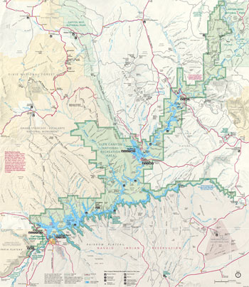 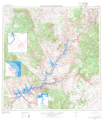 (click for larger maps) |
Water Sports Water dominates the activities at Glen Canyon National Recreation Area. Concessioners offer boat tours that last from one hour to all day and provide boat rentals at developed areas. Houseboats provide comfort at a relaxed pace, as well as a chance to sightsee beyond the developed areas. Canoes and kayaks give access to secluded areas in small canyons. Water in the lake is relatively warm from June through September, making swimming, snorkeling, SCUBA diving, and waterskiing enjoyable.
Camping There is excellent camping on flat sites along the lakeshore. You can supplement water sports with a hike in the desert side canyons on trails of your own choosing. Please use reasonable caution.
Backcountry Backcountry hiking requires advance planning and stamina, but the experience can outweigh the efforts of preparation and the exertion.
Mountain Biking Bicycles are restricted to traveling on vehicle roadways. Off-road travel is prohibited.
Fishing Fishing is rewarding all year. The primary game species are largemouth and striped bass, black crappie, catfish, bluegill, trout, and walleye. The cold water of the Colorado River below the dam provides excellent trophy trout habitat. Anglers frequently catch large rainbow trout upstream from Lees Ferry.
For a Safe Visit
Every year deaths result from simple mistakes made in this unfamiliar environment. Read the list of regulations, available in the park newspaper, at all marinas, fee stations, and launch ramps. See the safety exhibits at launch ramps and marinas. Learn how to protect yourself from danger.
Safety and Regulations
• Driving and Bicycling Motor vehicles and bicycles must
stay on roads in the park, except at Lone Rock, where off-road driving
is permitted in a limited, signed area, and on the Rim Trail where
bicycles are allowed on portions of the trail.
• Sand Digging a tunnel or cave in the sand is tempting, but sand can suddenly collapse, causing suffocation and death.
• Pets Pets must be on a leash at all times. Pets left in vehicles in hot weather even for a short time may suffer heat stroke and die.
• Weapons Possession or use of any loaded weapon except when legally hunting, violates federal law. Water balloon launchers are considered weapons, and their use is prohibited. Fireworks are illegal.
• Antiquities Federal law provides severe penalties for the removal or destruction of any cultural artifacts or sites. Sitting or walking on walls of prehistoric structures, walking off designated trails, even touching rock art degrades these treasures.
• Permits Permits required when hiking or camping on all Navajo Nation or BLM lands.
• Plants, Animals, Rocks, and Fossils All of these, including natural features, are protected within the park. Removing, disturbing, or destroying plants, animals, rocks, fossils, or natural features is illegal.
Water-related Activities
• Personal Watercraft Jet skis and all personal watercraft
are vessels; boating regulations govern their use. In Utah you must be
18 to operate a personal watercraft alone (unless you comply with state
personal watercraft operator conditions); in Arizona you must be 12.
• Personal Flotation Devices (PFDs) Every person on a vessel must have an accessible U.S. Coast Guard-approved PFD (life jacket) aboard. Children 12 and under must wear PFDs.
• Alcohol and Boating Boating under the influence of alcohol is dangerous and illegal. Many boating accidents are alcohol related.
• Speed All vessels must operate at wakeless speed when within 150 feet of another vessel, a waterskier, or a person in the water, and when in all signed marina areas.
• Bow Riding Federal regulations prohibit riding on the bow of a boat at speeds greater than wakeless.
• Waterskiing All boats towing a waterskier must have at least two people on board: a competent observer and the boat's operator. An orange or red flag must be held high when the skier is down in the water.
• Swimming Swim at your own risk. Never jump or dive from boats or cliffs. Invisible, submerged rocks make such activities extremely dangerous. There are no lifeguards in the recreation area.
Weather
The winter months have freezing temperatures. Summer months are very hot
with severe, daily thunderstorms that can flood side canyons quickly.
During severe weather, wait out storms in sheltered coves. Drink one
gallon of water daily during hot weather.
Camping
In developed areas camp only in designated campgrounds. Primitive
camping is allowed in designated sites only on the Colorado River below
the dam. At other locations in the recreation area you must be at least
100 feet from paved roads and outside of alcoves and archeological
sites. Stays are limited to 14 consecutive days, and a total of 30 days
per year. Permits are required to camp in the Orange Cliffs or along the
San Juan River above Clay Hills Crossing. On the Colorado River below
Glen Canyon Dam, fires are allowed only in grates. In the Escalante,
ground fires are prohibited.
Fishing and Hunting
Either an Arizona or Utah fishing license is required to fish on Lake
Powell. Both states sell reciprocal stamps to extend their license to
the other state. Licenses are sold at marinas and in nearby communities.
It is illegal to remove humpback or bonytail chub and razorback sucker.
Trapping and hunting are allowed; state laws apply.
Disposal of Human Waste
Anyone camping in the park within 14 mile of Lake Powell, the San Juan
River, or the Colorado River is required to carry and to use some device
for containing solid human wastes, unless toilets are available on the
beach. Use of plastic bags as receptacles for human waste is prohibited.
Containerized human wastes must be emptied at marina dump/pumpout
stations. Eight floating restroom/dump/pumpout stations are also
available.
Source: NPS Brochure (2000)
|
Establishment Glen Canyon National Recreation Area — April 18, 1958 |
For More Information Please Visit The  OFFICIAL NPS WEBSITE |
Documents
5,000 Cubic Feet Per Second Flow Study Glen Canyon Environmental Studies Phase II (Bureau of Reclamation, March 1990)
A Final Tabulation of Sites Recorded in the Greater Glen Canyon Area by the University of Utah During the Glen Canyon Project (Alan R. Schroedl and Daniel K. Newsome, extract from Utah Archaeology, Vol. 13 No. 1, 2000, ©Utah Statewide Archaeological Society and the Utah Professional Archaeological Council)
A Report on the History of Lee's Ferry, Arizona (C. Gregory Crampton and W.L. Rusho, January 1965)
Air Patrol Manual, Glen Canyon National Recreation Area (undated)
Annotated Checklist of the Birds of Glen Canyon National Recreation Area, Utah and Arizona (John R. Spence, Charles T. LaRue and John D. Grahame, October 10, 2005)
Archaeological Evaluation and Site Inventory in Glen Canyon National Recreation Area, 1978: Vol. I (Alan R. Schroedl, 1981)
Archaeological Evaluation and Site Inventory in Glen Canyon National Recreation Area, 1978: Vol. II (Alan R. Schroedl, 1981)
Archaeological sites in Grand Canyon National Park along the Colorado River are eroding owing to six decades of Glen Canyon Dam operations (Joel B. Sankey, Amy East, Helen C. Fairley, Joshua Caster, Jennifer Dierker, Ellen Brennan, Lonnie Pilkington, Nathaniel Bransky and Alan Kasprak, extract from Journal of Environmental Management, Vol. 342, May 12, 2023)
Archeological Research in Glen Canyon, 1977: Vol. I (Alan R. Schroedl, June 1981)
Archeological Research in Glen Canyon, 1977: Vol. II (Alan R. Schroedl, June 1981)
Archeological Research in Glen Canyon, 1977: Vol. III (Alan R. Schroedl, June 1981)
Assessment of Riparian Vegetation Patterns and Change Downstream from Glen Canyon Dam from 2014 to 2019 U.S. Geological Survey Open-File Report 2023-1026 (Emily C. Palmquist, Bradley J. Butterfield and Barbara E. Ralson, 2023)
Authorities for Water Resources Decision Making on the Colorado River Draft (April 1991)
Bacteria Water Quality Data Analysis and Interpretation, Glen Canyon National Recreation Area NPS Technical Report NPS/NRWRD/NRTR-95/46 (Barry A. Long and Rebecca A. Smith, July 1995)
Before Powell: Exploration of the Colorado River (Melvin T. Smith, extract from Utah Historical Quarterly, Vol. 55 No. 2, 1987; ©Utah State Historical Society)
Biological and Hydrological Surveys of Springs Along the Colorado River, Utah and Arizona: Surveys of Springs in the Colorado River Drainage in Arches National Park, Canyonlands National Park, Glen Canyon National Recreation Area, and Grand Canyon National Park — Part I Final Report (John R. Spence, February 2004)
Biological and Hydrological Surveys of Springs Along the Colorado River, Utah and Arizona: Surveys of Springs in the Colorado River Drainage in Arches National Park, Canyonlands National Park, Glen Canyon National Recreation Area, and Grand Canyon National Park — Part II - Appendices (A1-A5) Final Report (John R. Spence, February 2004)
Biological and Hydrological Surveys of Springs Along the Colorado River, Utah and Arizona: Surveys of Springs in the Colorado River Drainage in Arches National Park, Canyonlands National Park, Glen Canyon National Recreation Area, and Grand Canyon National Park — Part II - Appendices (A6) Final Report (John R. Spence, February 2004)
Biological and Hydrological Surveys of Springs Along the Colorado River, Utah and Arizona: Surveys of Springs in the Colorado River Drainage in Arches National Park, Canyonlands National Park, Glen Canyon National Recreation Area, and Grand Canyon National Park — Part II - Appendices (A7-A9) Final Report (John R. Spence, February 2004)
Breeding Birds Along the Colorado River Through Glen Canyon: The 1995 Report and an Historical Perspective (John D. Grahame and Clive A. Pinnock, September 1995)
Charles Kelly's Glen Canyon Ventures and Adventures (Gary Topping, extract from Utah Historical Quarterly, Vol. 55 No. 2, 1987; ©Utah State Historical Society)
Discovery of Glen Canyon, 1776 (David E. Miller, extract from Utah Historical Quarterly, Vol. 26 No. 3, 1958; ©Utah State Historical Society)
Diving Manual, Glen Canyon National Recreation Area (undated)
Draft Paleontology Resource Management Plan for Glen Canyon National Recreation Area, Southern Utah and Northern Arizona (Lex Newcomb and David D. Gillette, New Mexico Museum of Natural History & Science Bulletin 34, 2006, ©New Mexico Museum of Natural History and Science, all rights reserved)
Development Concept Plan: Lees Ferry, Environmental Assessment, Glen Canyon National Recreation Area, Arizona (December 1985)
Development Concept Plan, Environmental Assessment: Antelope Point, Glen Canyon National Recreation Area Final (March 1986)
Effects of Three High-Flow Experiments on the Colorado River Ecosystem Downstream from Glen Canyon Dam, Arizona USGS Circular 1366 (Theodore S. Melis, ed., 2011)
Effects of Varied Flow Regimes on Aquatic Resources of Glen and Grand Canyons Final Report (Henry R. Maddux, Dennis M. Kubly, James C. deVos, Jr., William R. Persons, Richard Staedicke and Rebecca L. Wright, May 1987)
Final Draft Historic Preservation Plan for Cultural Resources Affected by Glen Canyon Dam Operations (June 1997)
First Unambiguous Dinosaur Specimen From the Upper Triassic Chinle Formation in Utah (Xavier A. Jenkins, John R. Foster and Robert J. Gray, Geology of the Intermountain West, Volume 4, 2017, ©Utah Geological Association)
Fish management plan Glen Canyon National Recreation Area (April 1996)
Foundation Document, Glen Canyon National Recreation Area and Rainbow Bridge National Monument, Arizona-Utah (September 2014)
Foundation Document Overview, Glen Canyon National Recreation Area and Rainbow Bridge National Monument, Arizona-Utah (February 2015)
Geologic Resources Inventory Report, Glen Canyon National Recreation Area NPS Natural Resource Report NPS/NRPC/GRD/NRR-2016/1264 (J.P. Graham, August 2016)
Geology of the Circle Cliffs Area, Garfield and Kane Counties, Utah USGS Bulletin 1229 (E.S. Davidson, 1967)
Glen Canyon Bridge: Technical Record of Design and Construction (Bureau of Reclamation, November 1959)
Glen Canyon Dam: Long-Term Experimental and Management Plan/Environmental Impact Statement — Executive Summary Public Draft (December 2015)
Glen Canyon Dam: Long-Term Experimental and Management Plan/Environmental Impact Statement — Volume 1-Chapters 1-8 Public Draft (December 2015)
Glen Canyon Dam: Long-Term Experimental and Management Plan/Environmental Impact Statement — Volume 2-Appendices Public Draft (December 2015)
Glen Canyon Dam: Long-Term Experimental and Management Plan/Environmental Impact Statement — Executive Summary (October 2016)
Glen Canyon Dam: Long-Term Experimental and Management Plan/Environmental Impact Statement — Volume 1-Chapters 1-8 (October 2016)
Glen Canyon Dam: Long-Term Experimental and Management Plan/Environmental Impact Statement — Volume 2-Appendices A-N (October 2016)
Glen Canyon Dam: Long-Term Experimental and Management Plan/Environmental Impact Statement — Volume 3-Appendices O-Q (October 2016)
Glen Canyon Dam/Smallmouth Bass Flow Options Draft Environmental Assessment (Bureau of Reclamation, February 2023)
Glen Canyon Environmental Studies: Executive Review Committee Final Report (May 1988)
Glen Canyon Environmental Studies: Executive Studies of Technical Reports (October 1988)
Glen Canyon Environmental Studies Phase II Draft Integrated Research Plan: Volume 1 (August 1990)
Glen Canyon Environmental Studies Phase II Draft Integrated Research Plan: Volume 2 (August 1990)
Glen Canyon Institute Studies
Antique Plumbing & Leadership Postponed: How the Glen Canyon's Dam Archaic Design Threatens the Colorado River Water Supply (Utah Rivers Council, Glen Canyon Institute and Great Basin Water Network, August 2022)
Citizens' Environmental Assessment (CEA) on the Decomissioning of Glen Canyon Dam (December 2000)
Glen Canyon BioBlitz: 2019 (Larry Stevens, Steve Leavitt, Terry Griswold, Ronda Griswold, William Gray, Silvia Gray, John Spence, Grace Carpenter, Roy Morris, Tania Parra, Blake Wellard, Kendra Babitz, Tim Graham, Ronald J. Kass, Paul Dawson, Jeremy Webster, Lindi McIlwaine and Allison Jones, 2019)
Loss Rates from Lake Powell and Their Impact on Management of the Colorado River (Tom Myers, extract from Journal of the American Water Resources Association, February 20, 2013; ©American Water Resources Association)
Potential Legal Issues under the Law of the River Associated with the Fill Mead First Proposal (Larry MacDonnell, extract from The Water Report, Issue 112, June 15, 2013)
Preliminary biological research on plant species in restoring Glen Canyon tributaries (Marc Coles-Ritchie and Seth Arens, Date Unknown)
The Impact of the Loss of Electric Generation at Glen Canyon Dam (Thomas Power and Joel Brown, May 2015)
Glen Canyon Series (University of Utah)
1. The Glen Canyon Survey in 1957 (Robert H. Lister, University of Utah Anthropological Papers No. 30, March 1958)
2. Preliminary Report on Biological Resources of the Glen Canyon Reservoir (Angus M. Woodbury, et al., University of Utah Anthropological Papers No. 31, April 1958)
3. Mormon Towns in the Region of the Colorado (Leland H. Creer, University of Utah Anthropological Papers No. 32, May 1958)
4. The Activities of Jacob Hamblin in the Region of the Colorado (Leland H. Creer, University of Utah Anthropological Papers No. 33, May 1958)
5. Survey of Vegetation in Glen Canyon Reservoir Basin (Angus M. Woodbury, Stephen D. Durrant and Seville Flowers, University of Utah Anthropological Papers No. 35, January 1959)
6. The Glen Canyon Archeological Survey: Part I (Don D. Fowler, et al., University of Utah Anthropological Papers No. 39, May 1959)
6. The Glen Canyon Archeological Survey: Part II (Don D. Fowler, et al., University of Utah Anthropological Papers No. 39, May 1959; Note: Digital edition is incomplete)
6. The Glen Canyon Archeological Survey: Part III (Don D. Fowler, et al., University of Utah Anthropological Papers No. 39, December 1959)
7. Ecological Studies of Flora and Fauna in Glen Canyon (by Angus M. Woodbury, et al., University of Utah Anthropological Papers No. 40, June 1959)
8. The Coombs Site (Robert H. Lister and Florence C. Lister, University of Utah Anthropological Papers No. 41, July 1959)
8. The Coombs Site: Part II (Robert H. Lister and Florence C. Lister, University of Utah Anthropological Papers No. 41, 1960)
8. The Coombs Site: Part III, Summary and Conclusions (Robert H. Lister and Florence C. Lister, University of Utah Anthropological Papers No. 41, 1961) (Note: No digital edition available)
9. Outline History of the Glen Canyon Region 1776-1922 (C. Gregory Crampton, University of Utah Anthropological Papers No. 42, September 1959)
10. 1957 Excavations, Glen Canyon Area (James H. Gunnerson, University of Utah Anthropological Papers No. 43, 1959)
11. 1958 Excavations, Glen Canyon Area (William D. Lipe, University of Utah Anthropological Papers No. 44, 1960)
12. Historical Sites in Glen Canyon, Mouth of San Juan River to Lees Ferry (C. Gregory Crampton, University of Utah Anthropological Papers No. 46, 1960)
13. 1959 Excavations, Glen Canyon Area (William D. Lipe, Floyd W. Sharrock, David S. Dibble, Keith M. Anderson, Christy G. Turner II and Dee Ann Suhm, University of Utah Anthropological Papers No. 49, December 1960)
14. 1960 Excavations, Glen Canyon Area (Floyd W. Sharrock, Keith M. Anderson, Don D. Fowler, David S. Dibble, Christy G. Turner II and David M. Pendergast, University of Utah Anthropological Papers No. 52, May 1961)
15. The Hoskaninni Papers, Mining in Glen Canyon, 1897-1902 (Robert B. Stanton; C. Gregory Crampton and Dwight L. Smith, eds., University of Utah Anthropological Papers No. 54, 1961)
16. Carnegie Museum Collection From Southeast Utah (Floyd W. Sharrock and Edward G. Keane, University of Utah Anthropological Papers No. 57, 1962)
17. Historical Sites in Glen Canyon, Mouth of Hansen Creek to Mouth of San Juan River (C. Gregory Crampton, University of Utah Anthropological Papers No. 61, 1962)
18. 1961 Excavations, Glen Canyon Area (Floyd W. Sharrock, Kent C. Day, David S. Dibble, Erik K. Reed and John F. Lance, University of Utah Anthropological Papers No. 63, May 1963)
19. 1961 Excavations, Harris Wash, Utah (Don D. Fowler, University of Utah Anthropological Papers No. 64, 1963) (Note: No digital edition available)
20. 1961 Excavations, Kaiparowits Plateau, Utah (Don D. Fowler and C. Melvin Aikens, University of Utah Anthropological Papers No. 66, 1963) (Note: No digital edition available)
21. Southern Paiute Ethnology (Isabel T. Kelly, University of Utah Anthropological Papers No. 69, 1964) (Note: No digital edition available)
22. The San Juan Canyon Historical Sites (C. Gregory Crampton, University of Utah Anthropological Papers No. 70, 1964)
23. Kaiparowits Plateau and Glen Canyon Prehistory: An Interpretation Based on Ceramics (Florence C. Lister, University of Utah Anthropological Papers No. 71, July 1964)
24. Historical Sites in Cataract and Narrow Canyons, and in Glen Canyon to California Bar (C. Gregory Crampton, University of Utah Anthropological Papers No. 72, August 1964)
25. 1962 Excavations, Glen Canyon Area (Floyd W. Sharrock, University of Utah Anthropological Papers No. 73, 1964)
26. Notes on the Human Ecology of Glen Canyon (Angus M. Woodbury, University of Utah Anthropological Papers No. 74, May 1965)
27. Excavations in Southwest Utah (C. Melvin Aikens, University of Utah Anthropological Papers No. 76, 1965)
28. Southern Paiute Ethnohistory (Robert C. Euler, University of Utah Anthropological Papers No. 76, 1965)
29. Virgin-Kayenta Cultural Relationships (C. Melvin Aikens, University of Utah Anthropological Papers No. 78, April 1966)
30. Corn, Cucurbits and Cotton from Glen Canyon w/ A Tabular Summary of Plant and Animal Resources of the Glen Canyon Area (Hugh C. Cutler and Susan R. Clark, University of Utah Anthropological Papers No. 80, 1966)
31. Glen Canyon: A Summary (Jesse D. Jennings, University of Utah Anthropological Papers No. 81, June 1966)
Glen Canyon Series (©Museum of Northern Arizona)
1. An Inventory Of Prehistoric Sites On The Lower San Juan River, Utah (William Y. Adams, Nettie K. Adams, Museum of Northern Arizona Bulletin No. 31, 1959) (Note: No digital edition available)
2. Ninety Years of Glen Canyon Archaeology, 1869-1959 (William Y. Adams, Museum of Northern Arizona Bulletin No. 33, 1960)
3. Survey and Excavations in Lower Glen Canyon, 1952-1958 (William Y. Adams, A.J. Lindsay, Jr., and Christy G. Turner, II, Museum of Northern Arizona Bulletin No. 36, 1961)
4. Petrographs of the Glen Canyon Region: Styles, Chronology, Distribution, and Relationships from Basketmaker to Navajo (Christy G. Turner II, Museum of Northern Arizona Bulletin No. 38, 1971)
5. Survey and Excavations on Cummings Mesa, Arizona and Utah, 1960-1961 (J. Richard Ambler, Alexander J. Lindsay, Jr. and Mary Anne Stein, Museum of Northern Arizona Bulletin No. 39, 1964) (Note: No digital edition available)
6. Stratigraphic Sections and Records of the Springs in the Glen Canyon Region of Utah (Maurice E. Cooley, Museum of Northern Arizona Technical Series No. 6, 1965)
7. Archaeological Excavations in Lower Glen Canyon, 1959-1960 (Paul V. Long, Jr., Museum of Northern Arizona Bulletin No. 42, 1966)
8. Survey and Excavations North and East of Navajo Mountain, Utah, 1959-1962 (Alexander J. Lindsay, Jr., J. Richard Ambler, Mary Anne Stein and Philip M. Hobler, Museum of Northern Arizona Bulletin No. 45, 1968)
Glen Canyon Environmental Studies Final Report (January 1988)
Historic Structures Report: Lee's Ferry and Lonely Dell Ranch, Glen Canyon National Recreation Area, Arizona (Robert G. Graham and Douglas E. Kupel (Alliance Architects, LLC, September 2000)
Impacts of Visitor Spending on the Local Economy: Glen Canyon National Recreation Area, 2007 (Daniel J. Stynes, June 2009)
Implications of Early Bow Use in Glen Canyon (Phil R. Geib and Peter W. Bungart, extract from Utah Archaeology, Vol. 2 No. 1, 1989, ©Utah Statewide Archaeological Society and the Utah Professional Archaeological Council)
Junior Ranger Booklet, Glen Canyon National Recreation Area (2013; for reference purposes only)
Lee's Ferry at Lonely Dell (Juanita Brooks, extract from Utah Historical Quarterly, Vol. 25 Nos. 1-4, 1957; ©Utah State Historical Society)
Management/Development Concept Plans for Lake Powell's Accessible Shorelines: Glen Canyon National Recreation Area (November 1988)
Manual of Boat Operations, Glen Canyon National Recreation Area (undated)
Modern Landscape Processes Affecting Archaeological Sites along the Colorado River Corridor Downstream of Glen Canyon Dam, Glen Canyon National Recreation Area, Arizona U.S. Geological Survey Scientific Investigations Report 2017-5082 (Amy E. East, Joel B. Sankey, Helen C. Fairley, Joshua J. Caster and Alan Kasprak, 2017)
Monitoring Riparian Vegetation Composition and Cover Along the Colorado River Downstream of Glen Canyon Dam, Arizona U.S. Geological Survey Techniques and Methods 2-A14 (Emily C. Palmquist, Barbara E. Ralston, Daniel A. Starr and Taylor C. Johnson, 2018)
National Register of Historic Places Nomination Forms
Davis Gulch Pictograph Panel (Temple A. Reynolds, December 30, 1974)
Defiance House (Jim Dykman and Bruce Hawkins, July 12, 1978)
Hole-In-The-Rock (Temple A. Reynolds, December 10, 1974)
Hole-in-the-Rock Trail (A. Kent Powell, January 1979)
Hulk of Charles H. Spencer (James P. Delgado and Toni Carrell, January 31, 1989)
Lee's Ferry and Lonely Dell Ranch (Ann Huber, July 1997)
Lee's Ferry Historic District (Temple A. Reynolds, December 14, 1974)
Lonely Dell (Lonely Dell Ranch Historic District) (James A. Muhn, April 27, 1977)
Near-term Colorado River Operations: Revised Draft Supplemental Environmental Impact Statement (Bureau of Reclamation, October 2023)
Near-term Colorado River Operations: Final Supplemental Environmental Impact Statement (Bureau of Reclamation, March 2024)
Operation of Glen Canyon Dam Final Environmental Impact Statement: Summary (March 1995)
Park Newspaper: 1991 • 1999 • Summer 2005 • Spring 2006 • Summer 2006 • 2007 • 2008 • 2009 • 2010 • 2011 • 2012 • 2013 • 2014 • 2015 • 2016 • 2017
Piapaxa 'Uipi (Big River Canyon): Southern Paiute Ethnographic Resource Inventory and Assessment for Colorado River Corridor, Glen Canyon National Recreation Area, Utah and Arizona, and Grand Canyon National Park, Arizona (Richard W. Stoffle, David B. Halmo, Michael J. Evans and Diane E. Austin, June 1994)
Preliminary Report on the White Canyon Area, San Juan County, Utah USGS Circular Paper 217 (W.E. Benson, A.F. Trites, Jr., E.P. Beroni and J.A. Feeger, 1952)
Recent Vegetation Changes Along the Colorado River Between Glen Canyon Dam and Lake Mead, Arizona U.S. Geological Survey Professional Paper 1132 (Raymond M. Turner and Martin M. Karpiscak, 1980)
River and Dam Management: A Review of the Bureau of Reclamation's Glen Canyon Environmental Studies (National Academy Press, 1987)
Rock Formations in the Colorado Plateau of Southeastern Utah and Northern Arizona USGS Professional Paper 132-A (C.R. Longwell, H.D. Miser, R.C. Moore, Kirk Bryan and Sidney Paige, 1932)
Scientific Explorations in Southern Utah (Herbert E. Gregory, extract from American Journal of Science, Vol. 243, October 1945, reprint May 1950)
Search Manual, Glen Canyon National Recreation Area (Section 700, of the Glen Canyon NRA Ranger Manual, undated)
Soil Survey of Glen Canyon National Recreation Area, Arizona and Utah (2010)
Special Lake Powell Edition (Arizona Highways, Vol 58 No. 4, April 1982; ©Arizona Department of Transportation)
Statement for Management — Glen Canyon National Recreation Area: September 1985 • May 1989 • August 1991
Submerged Cultural Resources Site Report: Charles H. Spencer's Mining Operation and Paddle Wheel Steamboat Southwest Cultural Resources Center Professional Papers No. 13 (Toni Carrell, ed., James E. Bradford and W.L. Rusho, 1987)
Superintendent's Annual Reports: 2003
The Baker Ranch: A History, Glen Canyon National Recreation Area, Arizona-Utah (Lenard E. Brown, January 1, 1970)
The Colorado...River of the West (Utah Historical Quarterly, Vol. 28 No. 3, July 1960; ©Utah State Historical Society)
The Glen Canyon: A Multi-Discipline Project (Jesse D. Jennings and Floyd W. Sharrock, extract from Utah Historical Quarterly, Vol. 33 No. 1, 1965; ©Utah State Historical Society)
The Impact of the Loss of Electric Generation at Glen Canyon Dam (Donovan Power, 2016)
The John Wesley Powell Fossil Track Block: Theropod Tracks with Ornithopod-like Morphology from the Early Jurassic Navajo Sandstone, Glen Canyon National Recreation Area, Utah (Andrew R.C. Milner, Vincent L. Santucci, John R. Wood, Tylor A. Birthisel, Erica Clites and Martin G. Lockley, extract from Geology of the Intermountain West, Vol. 10, 2023)
The Lost World of Glen Canyon (P.T. Reilly, extract from Utah Historical Quarterly, Vol. 63 No. 2, 1995; ©Utah State Historical Society)
Topographic Map: Glen Canyon National Recreation Area, UT Scale: 1:250,000 (USGS, 1977)
Undiscovered to Undiscoverable: Gregory National Bridge (Jared Farmer, extract from Utah Historical Quarterly, Vol. 63 No. 2, 1995; ©Utah State Historical Society)
Vascular Plant Inventory of Glen Canyon National Recreation Area NPS Natural Resource Technical Report NPS/SCPN/NRTR—2009/264 (Mar-Elise Hill and Tina Ayers, November 2009s)
Water quality and quantity of selected springs and seeps along the Colorado River corridor, Utah and Arizona: Arches National Park, Canyonlands National Park, Glen Canyon National Recreation Area, and Grand Canyon National Park, 1997-98 USGS Open-File Report 2003-496 (Howard E. Taylor, John R. Spence, Ronald C. Antweiler, Kevin Berghoff, Terry I. Plowman, Dale B. Peart and David A. Roth, 2004)
Water Quality Monitoring Alternatives for the Glen Canyon National Monument Recreation Area Water Resources Management Plan Water Resources Report No. 86-3 (Mark D. Flora and Charles W. Wood, June 1986)
Water Quality of Springs and Seeps in Glen Canyon National Recreation Area NPS Technical Report NPS/NRWRD/NRTR-97/128 (Howard E. Taylor, Kevin Berghoff, Edmund D. Andrews, Ronald C. Antweiler, Terry I. Brinton, Christine Miller, Dale B. Peart and David A. Roth, July 1997)
Water Resources Management Plan Glen Canyon National Recreation Area Utah/Arizona (Charles W. Wood and Dan B. Kimball, April 1987)
glca/index.htm
Last Updated: 03-Feb-2025