|
POSSIBILITIES OF SHELTERBELT PLANTING IN THE PLAINS REGION
|
|
Section 12.—SOIL AND FOREST RELATIONSHIPS OF THE SHELTER BELTZONE
By F. A. HAYES, senior soil scientist, Division of Soil Survey, Bureau of Chemistry and Soils, and J. H. STOECKELER, junior forester, Lake States Forest Experiment Station, Forest Service
CONTENTS
General description of the soils
Outline of soil development
Northern section
Central section
Southern section
Prevailing features
Soil and tree relationships
Observations of tree roots
Depth of rooting of individual species
Variations of root habits in different soil types
Other factors that influence root habits of trees and shrubs
Description of major soil groups
Soils of the northern section
Soils of the central section
Soils of the southern section
Acknowledgments
Bibliography
What is the nature of the soils of the shelterbelt zone, and what types of tree growth, native or introduced, do the different soils now support? The answer to these questions will supply, to a very significant degree, the working data of afforestation projects in the area, on whatever scale they may be undertaken.
With a knowledge of the presence or absence of trees, with observation of the success or failure of previous plantings in thousands of localities, the soil map and the climatic data take on new meaning to the forester, offering definite guidance to the selection of vast acreages favorable to new growth.
To obtain the needed correlation between soil and forest types, a rapid survey was conducted in the entire region for which nationally sponsored tree shelterbelts were proposed.
The results of many years of work by the Bureau of Chemistry and Soils and the agencies of the several States were available in the form of either detailed county soil maps or soil-reconnaissance surveys over a considerable part of the area, and these were very fortunately supplemented by the reconnaissance soil erosion survey made by the Soil Conservation Service in the summer of 1934; consequently the main task was to make as thorough a canvass of the territory as possible in strictly limited time, carefully correlating soil-type classifications, observing kinds and conditions of tree growth, and referring each group of trees to its proper place on the soil map.
Field work included a study of the various tree and shrub species now planted or growing naturally in the region, particular attention being given to their age, height, vigor, and rooting habits in the various soils. In the 2 months allotted to the survey, 3 parties, traveling by automobile in the northern, central, and southern sections respectively, observed a total of about 10,000 plots or groups of trees within an area generally more than 100 miles wide extending from the Canadian boundary of North Dakota to Lubbock, Tex. Soil types were examined and many soil samples taken. With the assistance of farmers, 126 designated trees and shrubs were trenched and their root systems examined.
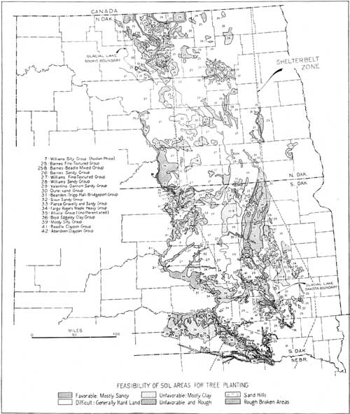
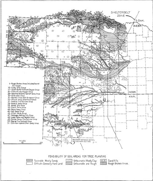
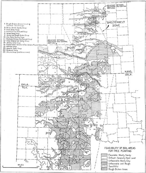
The data thus assembled may be considered fairly and definitely indicative of natural conditions broadly governing tree growth in the shelterbelt zone. The results of the survey are shown in simplified form in the maps (figs. 38, 39, and 40).
|
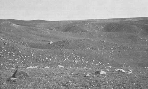
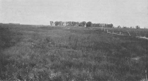
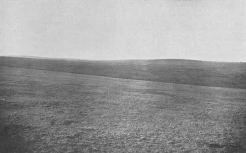
| FIGURE 36.—Rough morainic pasture land on Williams stony loam. Such land is unsuited to shelterbelt planting. Walworth County, S. Dak. (See text, p. 127.) |
|
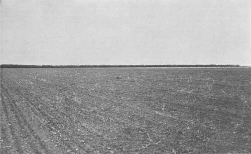
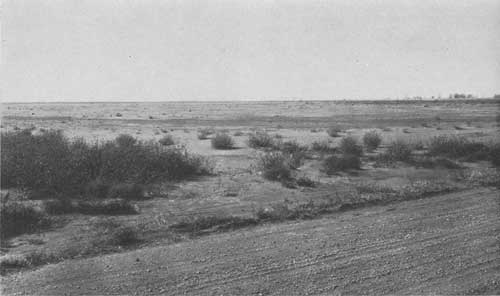
| FIGURE 37.—The Colby soils are among the most drought resistant of the finer textured upland soils. Most specie of trees do well on this type of soil in localities where the moisture supply is favorable. Typical undissected phase of Colby silt-loam soil in western Kansas, with green ash windbreak in background, 4 miles east of Goodland, Kans. (F296037) (See text, p. 142). |
|
| FIGURE 38.—Soil groups of the shelterbelt zone, northern section. (click on image for a PDF version) |
|
| FIGURE 39.—Soil groups of the shelerbelt zone, central section. (click on image for a PDF version) |
|
| FIGURE 40.—Soil groups of the shelterbelt zone, southern section. (click on image for a PDF version) |
Prevailing soil types are indicated on these maps by numbers placed within the respective soil boundaries, and upon the areas thus defined various crosshatchings are used to indicate the feasibility of growing trees on the different soil groups. The classification of the soils with respect to tree growth should not, however, be interpreted too literally on too small an area. The zone area amounts to tens of thousands of square miles and considerable variations of soil quality may be found within an area of one soil type as shown on the map. The variations may be favorable or unfavorable to tree growth. The purpose of the present mapping is, in short, to help to visualize general soil conditions. For actual planting, more detailed maps must be used to guide the work according to the actual site and the service to be rendered.
Within these limitations, the maps face us with certain broad realities.
(1) They indicate that tree belts cannot be created in any geometric pattern of uninterrupted, equidistantly spaced lines, but will have to be arranged more in accord with the dictates and habits of nature.
(2) The distribution of the soils, confirmed by observation of long-established plantings, indicates that successful tree growing can be expected over large areas throughout the zone. By "successful" tree growing is meant the reasonably easy establishment of groves of trees whose average life will be between 30 and 60 years and whose ultimate average height will range between 25 and 40 feet.
Estimates based on field conditions in the 115,000 square miles of the entire shelterbelt zone place the favorable, difficult and unfavorable soils at 56, 39, and 4 percent, respectively. In the 56 percent of the soils considered as favorable are included from 30 to 40 percent of those shown on the map as difficult. Certain soil types or groups, particularly loamy soils in the eastern half of the shelterbelt zone, receive enough precipitation to characterize them as favorable, but they grade off to the westward into the difficult class so gradually that it is not considered feasible to indicate their extent by definite crosshatchings on the map.
(3) Since the establishment of shelterbelts is a much more limited and selective project than the afforestation of an entire region, it is reasonable to suppose that the forester can change a considerable part of the difficult area to a favorable category and so successfully plant such sites by proper choice of species, careful ground preparation, listing, terracing, impounding water by dams, and by other water-conserving measures which are entirely practicable to undertake.
(4) The last and most important fact for our consideration is that the zone as shown on the map coincides with the area often referred to as the "bread basket of the Nation." The soil and topography of the area as a whole lend themselves admirably to the large-scale production of wheat, and much of the area is being so used. If this area is to be retained in a productive condition and its soils safeguarded against destructive wind erosion, shelterbelt planting, especially on certain critical soil types, seems at least a partial answer to the problem.
Among these critical types are sandy loam soils with sandy or gravelly subsoils. Such soils are much more subject to severe injury by wind erosion in a short time than other soil types, but at the same time they are among the most favorable in the Great Plains for tree planting; and it is entirely logical that the planting effort should be concentrated first and most intensively on them.
GENERAL DESCRIPTION OF THE SOILS
OUTLINE OF SOIL DEVELOPMENT
Geologic formations, through weathering, produce the parent materials of soils. The parent materials, largely inorganic, constitute the bulk of the soil complex and determine initially, and to a greater or less degree permanently, its physical characteristics.
From given parent materials soils have developed through processes involving the operation of climatic factors, the growth and decomposition of organic materials, the formation of new chemical compounds, the progressive disintegration and modification of less-resistant parent materials, the translocation of materials in the soil section, and the formation of a more or less layered profile.
The stage of development attained by the soil of a given region depends broadly on the climate and vegetation, but is influenced locally by the topographic and drainage conditions and by the resistance of parent materials. Soils which have developed for the longest periods under good drainage, without abnormal erosion, from parent materials easily affected by soil-forming processes are the most deeply and fully developed, and are commonly known as "mature soils." All of them in a given climatic, geologic, and vegetative region have the same number of well-developed layers or horizons, which occur in a definite order or succession and which differ from one another in one or more easily discernible features such as lime content, texture, structure, and compaction.
Most of the extensive soils of the shelterbelt zone are mature or are approaching maturity of development, although there are both large and small areas within the zone where development is regarded as immature on account of recent deposition as in bottom lands, or because of abnormal erosion, poor drainage, recent glacial action, or the resistant character of parent materials.34
34Not all immature soils are necessarily unfavorable to plant growth, as will be noted later in the case of important sandy areas.
To obtain the most general picture of the soils of the shelterbelt zone from the point of view of their origin and present development, it is convenient to block them out roughly under the three territorial sections of the zone—northern, central, and southern.
NORTHERN SECTION
The width of the shelterbelt zone as now delimited is everywhere 100 miles, measured along parallels of latitude. Its northern section is contained entirely in the States of North Dakota and South Dakota except for a minor overlap into Nebraska.
The soils over the greater part of this section, outside the alluvial river basins, have developed from highly calcareous glacial drift. A large proportion of them have been put under cultivation. They are friable (capable of being crumbled by the fingers) and, on the whole, are darker and more limy than any other upland soils within the zone. Most of them contain some pebbles and glacial boulders, and a few are composed largely of such materials.
Areas of wind-blown sandy soils with light-colored surface layers and low lime content occur in several places. The northern section also includes areas in which the soils have developed from heavy Cretaceous shales and are dense throughout. In addition there are numerous small basins in which standing water has produced heavy soils, and a few rather large areas in which alkali associated with periodically poor drainage has produced claypan soils.
CENTRAL SECTION
The central section of the shelterbelt zone adjoins the northern section at or near the north boundary of Nebraska and extends southwest through that State and thence south into north-central Kansas.
The greater part of the central section is covered by a level or gently sloping mantle of loess—a light-gray, limy, and floury silt, most of which has been deposited in the course of ages by winds blowing from a westerly direction. This material is very uniform in texture and color throughout the area of its distribution. From it soils have developed which owe their differences largely to variations in the luxuriance of the grass cover under which they have formed and in the amount of water to which they have been subjected. Most of them are friable, but a few have developed heavy claypan layers. They include the most productive upland soils of the section, and the greater part of the area occupied by them is under cultivation.
Much of the remainder of the central section is occupied by a large intruding area of the sand hills of north-central and southwest Nebraska. Derived largely from the disintegration of Tertiary sandstones but partly from late Pleistocene deposits, the sand over most of this area in times past has been whipped by the wind into the typical sand-hill topography. In the smoother areas and in poorly drained pockets and swales, the sandy soils have accumulated sufficient organic matter to have dark topsoils. Most of the land in the sand hills is used for grazing purposes or hay production.
North and east of the sand hills lies a considerable body of sandy and gravelly upland soils closely intermingled. These have accumulated much organic matter. The sandy soils, however, have the thicker top-soils and better moisture-holding capacity, and are more favorable to crop production. More than 50 percent of the gravelly soils are used only for grazing.
SOUTHERN SECTION
The southern section of the zone extends from north-central Kansas through western Oklahoma and the eastern part of the Texas Panhandle, and ends at about latitude 32°30" in northwest Texas. Most of the soils in this section have developed from parent materials which in the northern and central sections are absent, deeply buried, or present only as local outcrops.
A somewhat prominent feature of the southwestern Kansas area, which appears in the Oklahoma portion to a less extent, is the High Plains on which the soils have developed from fine-textured Tertiary and Quaternary materials containing considerable proportions of clay. Here the soils are deeply developed and are somewhat heavy, especially in their subsoil layers. They intrude into the shelterbelt zone on southeastward extensions of the extremely flat formation known further west as the "Llano Estacado" or "Staked Plains."
In Kansas and Oklahoma the soils of the High Plains have a wide range in textural features. Those formed from the most finely divided deposits have silty, brownish topsoils overlying lighter brown or yellowish silty clay subsoils. Those over the sandier deposits have developed into light-brown sandy soils with subsoils ranging from yellow or reddish-brown sandy loam to sandy clay loam. On the escarpment or breaks bordering the smooth High Plains, the soils are on rather severely eroded Tertiary deposits and have thin, poorly developed topsoil and subsoil layers.
East and south of the escarpment lies the rolling plain, forming the main portion of the shelterbelt zone in Oklahoma and Texas and a considerable portion in southern Kansas. It is occupied largely by red beds locally capped with Tertiary and Quaternary remnants. It has a great variety of soils, most of which are reddish and moderately to extremely sandy. In southwestern Oklahoma, however, some of the smoother lying soils on the rolling plain have dark silt loam or clay loam surface layers which are underlain by heavier subsoils. The latter, in places, are of claypan character.
In the extreme southern part of the zone, sandy material of reddish color thinly mantles fine-textured Tertiary deposits of the high plains formation, and here distinctly red or reddish-brown sandy soils are common.
PREVAILING FEATURES
None of the factors which contribute toward soil development is uniform throughout the proposed shelterbelt area. The semiarid climate and especially the grass vegetation have, however, given the soils of the area as a whole two outstanding features, namely, dark topsoils containing a greater or less proportion of black decomposed organic material, and a zone of calcification or lime enrichment at a comparatively shallow depth in their subsoils, marking in a general way the lower limit of water percolation from the surface. These features are present in varying degrees in the soils of 85 percent or more of the area.
DARK TOPSOILS
The darkest topsoils occupy situations where the grass growth is or has been luxuriant, where vegetal decay is relatively rapid, and where the topography favors accumulation of the decayed residue. In the shelterbelt zone such conditions occur in restricted areas such as bottom lands and terraces and in wet pockets on sandy land. On a larger scale they occur on the well-drained uplands across the northern end of the zone and along its eastern edge through Nebraska and the Dakotas, where the precipitation has been sufficient to support a dominantly tall-grass vegetation. The extensive root systems of the tall grasses, upon decaying, produce large amounts of black carbonaceous material which becomes intimately mixed with the mineral-soil constituents. This material, except in spots where erosion by wind or water has been especially severe, has imparted a very dark brown or almost black color to the topsoils, forming what are known as Chernozem (black soil) after nomenclature originally used in Russia. The color averages darkest in the Dakotas, as already noted.
Elsewhere throughout the shelterbelt zone the grass growth is less luxuriant. Tall grasses occur along the eastern edge of the zone in Kansas, Oklahoma, and Texas, but owing to their bunch habit of growth they do not supply as much carbonaceous material as the grasses farther north. Consequently the intensity of darkness in the topsoil layers here is less pronounced, the soils being designated generally as chestnut colored.
Westward across the zone, tall grasses gradually disappear, except on sandy lands or in unusually moist situations, and most of the soils have developed under a short-grass cover. Vegetal decay is relatively slow and incomplete, and the topsoils are lighter in color than those developed under the tall bunch-grass cover. The color may range from chestnut brown to reddish brown or even, in the extreme south, to red, the more reddish colors being imparted mainly by the parent Red-Bed formations.
ZONE OF LIME ENRICHMENT
The zone of lime enrichment is a product of the vegetation, climate, and parent soil material. Practically all the geological formations from which the soils of the shelterbelt area have developed contain lime. The roots of the grass plants bring the calcium and other basic compounds within reach to the surface horizons. Upon decay of the grass, these compounds are released and carried downward by moisture. Thus the topmost soil layers are gradually cleared of lime. But where precipitation is insufficient to penetrate the soil deeply, the soluble compounds are leached to a comparatively shallow level, where they are reprecipitated and gradually accumulate to a maximum concentration. Thus there is built up, under a topsoil practically free of lime, a layer of higher lime content than occurs elsewhere in the entire soil profile.
A zone of lime enrichment is not usually present in the more sandy soils of the region nor in the alluvial soils along drainage ways. Neither is it present in some of the soils occupying undrained upland basins where the moisture, accumulating from both precipitation and run-off, is sufficient to remove the lime to the water table.
In most of the soils, the depth or shallowness of the lime zone is a reliable indicator of the abundance or scarcity of the precipitation and of its ability to support trees and vegetative growth in general. This rule does not hold, however, over the greater part of the glaciated country in the Dakotas, where the lime lies nearer to the surface of the ground than the amount of precipitation would seem to warrant. This condition is ascribed to the lateness of the glacial epoch, insufficient time having yet elapsed for the precipitation to remove the lime from the upper part of the unusually calcareous parent material.
SAND AND GRAVEL SOILS
Aside from the dark color of topsoils and the layer of lime enrichment, which occur fairly generally throughout the zone, other soil features such as texture and degree of friability or compaction are far from uniform. They vary from place to place, according to the character of the parent material and the topographic and drainage conditions. Where the parent soil materials are coarse siliceous deposits, which are extremely resistant to weathering, most of the soils are of a sandy or gravelly nature. Within the zone boundaries, large areas of sandy soils exist, particularly in the glacial Lake Dakota Basin of South Dakota, in the sand hills of Nebraska, in southwest Kansas, and in the Panhandle sections of Texas and Oklahoma. Narrow strips of extremely sandy soils, usually associated with strips of finer textured soils, are common on the first bottoms and terraces of streams.
Owing to their resistant nature, few of the materials of high sand content have made much progress toward soil development. While they have generally accumulated more or less organic matter, the greater part are light colored, even at the surface, and show little change downward either in color or texture. Unless protected by adequate vegetative cover, they are subject to destructive wind erosion.
Nevertheless, the sandy soils of the zone as a whole rate high in the scale of vegetative capacity. Their greatest asset is their rapid absorbing power, which permits a higher percentage of retention from available precipitation, deeper penetration, lower wilting coefficient, and more even distribution of absorbed moisture than is the case in fine-textured soils. The largest areas of gravelly soils are those occurring north and east of the main sand-hill body in Nebraska and on hills, knobs, and ridges in parts of North Dakota and South Dakota. Terrace areas having coarse gravelly soils occur in several of the lake depressions and stream valleys of the Dakotas.
Gravelly soils, being more stable than sandy soils, have accumulated more organic matter. As a rule, they have rather dark colored but thin topsoils. Some of them, especially on the terraces, have zones of lime enrichment. They take up moisture at least as rapidly as sandy soils, but pass much of it to the under drainage, especially in localities where the surface soil is thin. These soils, except where the water table is shallow, are usually droughty.
"HEAVY" SOILS
A considerable area of very heavy soils developed from shale occurs north and south of the Dakota-Nebraska line within the shelterbelt zone. They have dark, clayey surface layers underlain by subsoils composed of dense clay. All of them have high moisture-holding powers but absorb water very slowly, losing much of the precipitation as run-off. During seasons of frequent rainfall such soils may be very productive, but in dry periods the topsoil moisture evaporates, the clay shrinks and cracks, and they become extremely droughty.
The soils of the High Plains of southwestern Kansas that have developed from the more finely divided Tertiary deposits are fairly heavy, and they probably absorb moisture only slowly. Yet they are not compact and are easily penetrated by roots.
Rather extensive areas of heavy soils developed from bedrock clays and shales of Permian and Triassic age occur in the Oklahoma and Texas portions of the shelterbelt zone. These soils have slightly lighter colored surface layers than those in Nebraska and the Dakotas, but have similar moisture relationships.
Heavy soils in lake beds and basins, some underlain by claypans, occupy small scattered bodies over nearly all parts of the shelterbelt zone. They are of little agricultural value, owing to their clayey nature and poor underdrainage. Locally they may be alkaline especially in the Dakotas.
Soils in which salts have contributed to the development of claypans are found at a number of places, particularly in South Dakota and Nebraska, but they comprise only a small part of the zone. They have been formed through the action of sodium carbonate, which, under certain chemical and moisture conditions replaces the flocculating calcium and magnesium salts and destroys the granular structure of the soil. The finer soil particles become mobile and are easily carried down by percolating water into the upper part of the subsoil, which they increase in thickness and density. In a few cases the sodium salts have caused the development of typical Solonetz soils, which mark a definite stage in the evolution of true alkali soils. These are characterized by dark and extremely dense claypans which break into prisms and vertical round-topped columns, the tops of which may be covered with a light-colored layer of loose siliceous material.
SOILS OF INTERMEDIATE TEXTURE
Between the extremes represented by sand and gravel on the one hand and clay on the other, the soils of the shelterbelt zone present a wide range in textural features and in the degree of compaction which they have attained, but over the greater part of the zone they are neither extremely sandy nor extremely clayey.
In the glaciated section of the Dakotas most of the upland soils, although more or less stony, range in texture from silt loam to fine sandy loam and are friable. The subsoils are only slightly heavier than the topsoils. The soils developed from loess, which occupy most of the uplands in southern Nebraska and northwest Kansas, are composed largely of silt (intermediate in fineness between sand and clay), and with few exceptions, are friable. They have rapid moisture-absorbing capacities, ranking almost as high in this respect as soils of a considerably more sandy nature, but they are more subject to water erosion than sandy soils, and along drainage ways the parent loess is exposed in numerous places.
The soils of the rolling plains of Texas, Oklahoma, and southern Kansas, while predominantly sandy, usually contain sufficient clay to hold the sand grains loosely. They have rapid moisture-absorbing capacities but erode easily.
SOIL AND TREE RELATIONSHIPS
The general aspect of the region in which the shelterbelt zone lies is that of a level to gently rolling plain devoid of native trees except along stream courses and in a few other favored localities. The landscape is, however, dotted here and there with shelterbelts and other farmstead tree plantings. These planted trees are growing with varying degrees of vigor on all but a few of the soil types found in the zone. Aside from a few species which show special soil adaptations, the vigor and the percentage of survival of trees throughout the well-drained uplands and terraces increases with the sand content of the soils and decreases with the clay content. This phenomenon is related to the available moisture supply in the sandy and clayey soils at all times, and especially during droughts.
The precipitation within the shelterbelt zone, although moderate, is probably everywhere sufficient to maintain tree growth if all, or even the greater part of it, were made available to the tree roots. Its effectiveness, however, in supplying soil moisture is rather low over most of the area occupied by fine-textured soils, especially in the western part of the zone, where the precipitation is lowest, and in the southern part, where evaporation is highest.
The relative ineffectiveness of the precipitation on the fine-textured soils is not due to any lack of water-holding capacity of such soils. Investigations have shown that a 6-foot column of silty or clay loam soil is able to carry more than twice as much water available to plants than an equal column of coarse sandy soil.35, 36 The decreased effectiveness of the finer textured soils under precipitation conditions encountered in the shelterbelt zone is to be attributed to their slow rate (rather than total potential volume) of moisture absorption, to the resulting relatively large run-off, to the retention of water mostly in the upper soil layers, and to the high wilting coefficient of the soil. That the first two characteristics mentioned reduce the effectiveness of the precipitation for vegetative growth is obvious. The third may favor some farm crops but is definitely unfavorable to trees, in a region of moderate precipitation, because it keeps much of the absorbed moisture near the surface of the ground, where evaporation is greatest and where the moisture is not available to the deeper tree roots.
35KING, F. H. SOIL MANAGEMENT. 311 pp., illus. New York. 1914.
36BURR, W. W., and RUSSELL, J. C. REPORT OF CERTAIN INVESTIGATIONS ON THE CENTRAL NEBRASKA SUPPLEMENTAL IRRIGATION PROJECT. Nebr. Dept. Pub. Works, Ann. Rept. 15: 199-240, illus. 1923-24.
The fourth characteristic relates to the amount of moisture retained by the soil at the time plants wilt beyond recovery. This is residual moisture which is unavailable, or too slowly available to sustain life. The amount is influenced somewhat by the character of the vegetation and also by atmospheric conditions, but it is controlled largely by the texture of the soil. It is small in the sandy soils, frequently as low as 4 percent, whereas in some of the fine-textured soils it may amount to more than 15 percent and in exceptional cases be as high as 30 percent. Although most of this unavailable moisture is a permanent soil feature, a certain amount of it, in the topsoil, is subject to evaporation, and the part so lost must be replaced by precipitation before any moisture can be come available to plants. Thus the effectiveness of light showers is likely to be much less on fine-textured than on sandy soils; in fact, a rainfall of less than one-half inch is of little benefit to vegetation on any of the fine-textured soils of the shelterbelt zone, unless it comes while the surface is still moist from a preceding rain. Below depths of 2 or 3 feet these soils never attain their field-carrying capacity, except possibly in years of highest precipitation.
The relative ineffectiveness of such soils in taking up precipitation and making it steadily available for plant growth is confirmed by such investigations as have been made to correlate precipitation and soil moisture in soils of the shelter-belt zone. In three series of studies which are of record, conducted on fine-textured crop soils in Oklahoma,37 Nebraska,38, 39 and North Dakota,40 it was found that the average proportion of annual precipitation stored in the soil and made available to plants ranged from 18 to 25.9 percent, with an exceptional low at one station of 14.2 percent. By reference to Weather Bureau precipitation records for the various stations it appears that the amount of water thus stored ranged from 3 to 4.7 inches.
37FINNELL, H. H. THE UTILIZATION OF MOISTURE ON THE HEAVY SOILS OF THE SOUTHERN GREAT PLAINS. Okla. Agr. Expt. Sta. Bull. 190, 24 pp. 1929.
38BURR, W. W. THE STORAGE AND USE OF SOIL MOISTURE. Nebr. Agr. Expt. Sta. Research Bull. 5, 88 pp., illus. 1914.
39ZOOK, L. L. DRY LAND CROP PRODUCTION AT THE NORTH PLATTE EXPERIMENTAL SUBSTATION. Nebr. Agr. Expt. Sta. Bull. 279, 49 pp., illus. 1933.
40THYSELL, J. C., MCKINSTRY, H. C., TOWLE, R. S., and OGAARD, A. J. DRY FARMING INVESTIGATIONS IN WESTERN NORTH DAKOTA. N. Dak. Agr. Com. Bull. 110: 159-207, illus. 1915.
Most of the preceding figures apply to points west of the shelterbelt zone, where the precipitation, and consequently the moisture actually absorbed by the soils, is lower than within the zone. Since it may be reasonably assumed, however, that the ratio between precipitation and moisture absorbed by similar soils remains fairly constant in a given latitude within the particular region, the data become significant in determining the probable effectiveness of the precipitation on the fine-textured soils in different parts of the zone.
As elsewhere indicated, the mean annual precipitation within the shelterbelt zone ranges from about 16 to about 28 inches. If 25 percent of this, which is not an unreasonable allowance, can be absorbed by the fine-textured soils, the effective moisture carried by such soils amounts to 7 inches per annum under the higher precipitation. Under the lower one it is 4 inches, and over the zone as a whole it averages 5.4 inches per annum.
The question naturally arises, Are these amounts of moisture sufficient to sustain vigorous tree growth, especially after the moisture stored in the deeper layers during some past rainfall cycle has been exhausted? This question, in the light of present information, cannot be answered. It can only be stated that the condition of the older trees, over much of the uplands occupied by fine-textured soils, indicates a severe moisture deficiency.
Drought has greatly affected a large percentage of the planted stand, particularly in the western part of the zone, where a very large percentage of the trees in many of the groves are dead or dying. The mortality has been greatest on the more clayey and least on the more silty types of the fine-textured soils.
It must be admitted, however, that few of these trees received adequate care after planting and that many of them are of species not best suited to their present soil and climatic environments. Fire, disease, insect pests, rodents, hail, and sleet have taken a heavy toll. Under good management, involving careful selection of trees and planting sites, proper precautions against damage, and the conservation of moisture through tillage, mulching, or through surface obstructions designed to utilize the run-off, the mortality can undoubtedly be lowered materially.
Most of the trees now growing on fine-textured upland soils within the zone seem to make fairly good growth during early life. Later, usually within a period of 20 years, growth, particularly in height, practically ceases. Whether the growth decline coincides with exhaustion of a previously stored subsoil moisture supply has not been determined for trees within the shelterbelt zone. Data indicating that such moisture has been exhausted in orchards in parts of southeastern Nebraska have been recently obtained by the horticulture department of the University of Nebraska.41
41WIGGANS, C. C. THE EFFECT OF ORCHARDS ON SUBSOIL MOISTURE. Nebr. State Hort. Soc. Rept. 1935. (In press.)
During droughts, trees on the finer-textured soils in the shelterbelt zone must depend almost entirely upon deeply stored moisture, usually of very small amount. Showers or light rains afford little benefit to these trees, aside from temporarily reducing the transpiration loss, because they do not appreciably replenish the soil-moisture supply. If the drought, which usually is accompanied by hot desiccating winds, is sufficiently prolonged, the trees on the finer soils rapidly reduce the supply of soil moisture to a point where it will no longer support them.
On sandy soils very few of the natural or planted species have succumbed to drought. This is true despite the fact that such soils are unable to store as much moisture as fine-textured types, that they occur in a region where the precipitation is not usually frequent, and that the water received during any single storm seldom exceeds the field-carrying capacity of a 6-foot section. But since a higher proportion of the stored moisture is available to plants during the intervals between replenishments, a closer balance is maintained than is usually supposed, and the under drainage loss is not great except in extremely coarse soil.
In sandy soils the moisture is evenly distributed to greater depths than in fine-textured soils, which encourages the development of deeper and wider root systems. Sandy soils permit little water to be lost by surface run-off and evaporation. In contrast to fine-textured soils their available moisture supply is appreciably replenished by light rains, even during droughts. These favorable factors enable them to supply a higher percentage of the total precipitation to the trees than is supplied by the heavier soils.
The only soils in the shelterbelt zone on which apparently little attempt has been made to grow trees occur on coarse gravel knobs and hills and in numerous poorly drained basins.
The gravelly soils occupy small areas, chiefly in the Dakotas. Their moisture content is too low to support more than a scant cover of short grasses and cacti.
The basin soils occur in poorly drained lake beds within the glaciated section of the Dakotas and in small undrained depressions on the more nearly level uplands and terraces throughout the remainder of the zone. They are periodically covered with water, sometimes for several weeks. These soils are composed largely of clay, which shrinks and cracks badly when the water evaporates. No trees seem able to adapt themselves consistently to this wide range in moisture conditions.
Alkaline areas occupy less than 1 percent of the land in the shelterbelt area. They occur chiefly in basin-like depressions and in claypan soils of the Dakotas. None of them are well suited to tree growth.
OBSERVATIONS OF TREE ROOTS
The root systems of 126 trees and shrubs occurring in the shelterbelt zone, 84 on fine-textured and 42 on sandy soils, were examined during the progress of the survey. They were studied from trenches or pits sunk close alongside the tree, 6 to 10 feet long, wide enough only for ample working room, and usually as deep as the deepest root exposed but seldom deeper than 10 feet. Where roots penetrated to an unusual depth, excavations were extended by means of augers, and the maximum root depth was roughly determined from fragments in the borings.
The roots were undermined on the pit wall nearest the tree by means of iron bars and ice picks. Their average spread was estimated or was determined by means of trenches which followed one of the main horizontal roots. Drawings or photographs were made of the exposed part of the root system, although in the drawings no attempt was made to indicate the more fibrous portions.
Data were also obtained on the location, history, species, age, height, diameter, vigor, class, spacing, and dominance of the tree; the soil profile was described and notes were taken concerning drainage conditions, topography, and the depth of the ground water. The soil was sampled by horizons for later study.
For present purposes, the point of chief interest is the depth of root penetration in the different soils. It was assumed at the beginning that the larger, older, and more drought-resistant trees would be found supported by a deeper root system than trees of the opposite description. Field observations indicate that this assumption is usually correct. Except in areas where the ground water lies high, the shallow-rooted trees of the shelterbelt zone are more subject to serious injury or death during periods of deficient precipitation. Many of the deeper rooted trees, however, were subject to considerable injury during the recent great drought, especially the older ones growing on fine-textured upland soils.
The data obtained seem to warrant the following general conclusions concerning the rooting habits of trees in soils of the shelterbelt zone.
1. Rooting is invariably deeper in sandy than in fine-textured soils in all localities where the water table is beyond the reach of tree roots.
2. Among the fine-textured upland soils, rooting is deeper in those developed from loess than in those developed from other geologic formations, that is, in the loess-derived soils of Nebraska and northwestern Kansas.
3. Rooting is shallowest in the fine-textured drift-derived soils of the Dakotas.
4. Rooting in the fine-textured soils of southwestern Kansas and the Texas Panhandle is intermediate in depth between that in the northern section (Dakotas) and the central section (Nebraska-Kansas) of the shelterbelt zone.
5. The roots of most trees are more numerous above the zone of lime enrichment, that is, within the upper 2 or 3 feet of the soil section where such factors as moisture, aeration, nutrients, temperature, and soil organisms are most favorable for growth.
DEPTH OF ROOTING OF INDIVIDUAL SPECIES
In addition to the above general observations, it was found that some species have a tendency to be shallow-rooted while others invariably showed strong, deep-penetrating root systems. The following list, based on the observation of 84 root systems of trees growing on fine-textured soils, indicates the relative rooting depths of the respective species under the condition regarded as critical. The other 42 trees, growing on sandy soils, were generally deeper rooted. The trees studied were usually between 20 and 40 years of age.
CLASSIFICATION OF TREES WITH RESPECT TO ROOTING DEPTH
Deep-rooted (10 to 20 feet in depth):
Ponderosa pine1
Hackberry2
Honeylocust1
Bur oak1
Mulberry1
Osage-orange1
Intermediate (5 to 10 feet in depth):
Green ash1
American elm2
Red cedar
Russian-olive
Caragana
Boxelder
Black locust1
Shallow-rooted (1 to 5 feet in depth):
Jack pine
Scotch pine2
Norway spruce
White willow
Cottonwood2
Catalpa
1Usually strongly taprooted.
2Occasionally strongly taprooted.
The species listed in the first and second groups, although more or less injured recently by a moisture deficiency, have survived the long drought much better than those listed in the third group. Most of the species of the latter group are not well suited to shelterbelt planting on fine-textured soils having low water tables. In general, they are relatively fast-growing species which require an abundance of moisture in the upper soil layers and are subject to early injury during periods of low precipitation. Trees of the first two groups, having deep or intermediate root systems, are not so soon affected by drought, especially if any deep soil moisture is available. It was also observed that trees of the same species were more likely to have a strongly developed taproot on the sandier soil.
There is apparently little difference in the drought resistance of species in the deep-rooted and inter mediate groups. The latter includes some species which, owing to their slow growth rate, use the sub-soil moisture very slowly and are as drought resistant as most of those in the first group. Observations indicate that the slower-growing trees of the shelterbelt zone have the greater life span.
VARIATIONS OF ROOT HABITS IN DIFFERENT SOIL TYPES
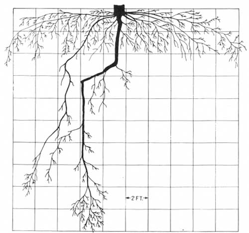
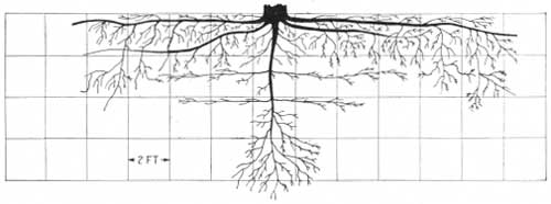
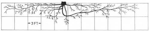
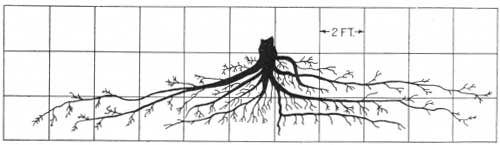
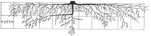
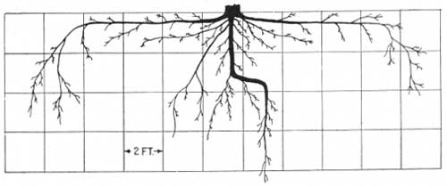
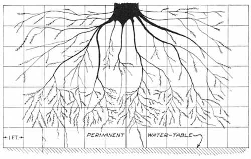
Although most species have a mode of rooting which is inherent, many of them show remarkable variations in their rooting habits, even within a limited area, depending on the texture of the soil, which, in turn, influences the moisture supply. Figures 41 and 42, which are drawings of the root systems of native (not planted) trees, are given as illustrations. Figure 41 represents the roots of a 30-year-old American elm growing on a small sand dune. The taproot, which is 20 feet long, extends to the water table. Figure 42 illustrates the root system of a 50-year-old tree of the same species growing on a heavy silty clay soil in the bottom land. It has little taproot, and the maximum depth of any root as exposed in the pit is about 6 feet.
|
| FIGURE 41.—Root system of 30-year-old native open-grown American elm in dune sand, McHenry County, N. Dak. Height of tree, 17 feet: diameter breast high, 6.3 inches; vigor, fair; care received during growth, none. Topography, strongly rolling; subsoil, fine sand; zone of lime enrichment, absent; depth of water table, 20 feet. |
|
| FIGURE 42.—Root system of 50-year-old native dominant American elm in Lamoure clay loam, McHenry County, N. Dak. Height of tree, 45 feet; diameter breast high, 11.8 inches; vigor, fair; care received during growth, none. Topography, level; subsoil, silty clay loam; zone of lime enrichment, 2.5 to 3.5 feet; depth of water table, about 15 feet. |
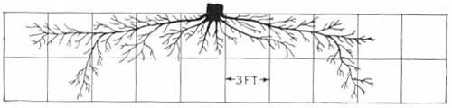
Roots of the same tree may react differently at various depths where pronounced changes occur in the physical composition of the soil. Figure 43 illustrates the root system of a planted 40-year-old American elm growing on a sandy soil in which two thin clay layers occur at depths of 3 and 4.2 feet, respectively. These layers temporarily check the downward movement of soil moisture, and strong laterals from the taproot have extended over them radially for distances of 4 to 6 feet.
|
| FIGURE 43.—Root system of 40-year-old codominant American elm (planted in Windbreak) in Sioux sandy loam, McHenry County, N. Dak. Height of tree, 40 feet; diameter, breast high, 9.4 inches; vigor, poor; care received during growth, fair. Topography, almost level; subsoil ranges from coarse sand to gravel; two thin clay layers (average thickness about 3 inches) at depths of 3.0 and 4.2 feet; zone of lime enrichment, not definite, some traces of lime at a depth of 4 feet; depth of water table, 10 feet. |
Generally, the trees observed on upland soils of high clay content, especially on claypan soils, were distinctly inferior in height, vigor, and longevity to trees on more friable soils in the same climatic region. This difference is probably due to some extent to poorer aeration in the heavier soils, in addition to their slower water-absorbing characteristic. In claypan soils the situation is extremely unfavorable. The "pans" lie at depths of 1 to 2 feet and are 6 to 16 inches thick. They undoubtedly interfere seriously with percolation, keeping most of the absorbed moisture in the upper soil layers, where it speedily evaporates.
As a rule, the trees examined on clayey and claypan soils were little if any shallower in their rooting habit than those on fine-textured associated soils of more friable character. An occasional tree, however, showed a decided aversion to deep-rooting in clayey soils, especially where a claypan was well developed. Figure 44 shows how the taproot of a 46-year-old green ash turned horizontally and stayed above the claypan, which was between depths of 0.6 and 2.0 feet. Doubtless a higher moisture supply above than within the claypan influenced the behavior of this root.
|
| FIGURE 44.—Root system of 46-year-old open-growth green ash (planted in windbreak) in Beadle silt loam (a claypan soil), Beadle County, S. Dak. Height of tree, 23 feet; diameter, breast high. 4.7 inches; vigor, poor; care received during growth, poor; land used as pasture for the last 20 years. Topography, almost level; subsoil, claypan at 0.6 to 2 feet, a dense tight clay; from 2 to 4 feet soil is clay loam, below 4 feet, silty clay; zone of lime enrichment, 2 to 4 feet; depth of water table, 30 to 40 feet. |
Figure 45 reveals the superficial character of the root system of a 38-year-old green ash growing in the clayey soil of a depression known locally as a "buffalo wallow." The tree was only 15 feet high. The soils in these depressions are particularly unfavorable to tree growth because of poor aeration and a wide periodic fluctuation of moisture, ranging from inundation to extreme dryness. Moreover, some of the basin soils are very alkaline.
|
| FIGURE 45.—Root system of 38-year-old codominant green ash, planted in windbreak in Fargo silty clay loam (undrained basin), Hyde County, S. Dak. Height of tree, 15 feet; diameter, breast high, 3.9 inches; vigor, poor; care received during growth, poor—grove has been used by livestock for the last 14 years. Topography, Slightly rolling, 1.5 percent slope; subsoil, silty clay; zone of lime enrichment, 2.8 to 4.3 feet; depth of water table, probably 8 or 10 feet. |
Before starting the root study, it was thought that the layer of lime accumulation or lime zone which has been described might inhibit the root growth of certain species because of its concentration of carbonates. The assumption was based partly on observations of several forest nurseries and of a few plantings on the Great Plains in which some seedlings become chlorotic and died. Death was attributed in most cases to an excess of carbonates and alkalis, which were thought to have toxic effects. However, none of the native or introduced trees which are best adapted to Plains planting seem to be seriously affected by the zone of lime accumulation in the soils. This zone in some fine-textured soils of the Dakotas contains 8 percent or more of calcium carbonate, but even in those soils the roots of most of the hardier native or near-native tree species and shrubs examined penetrated the limy layer quite readily. Such species, through long-continued adjustment, have probably become adapted to soils of relatively high lime content. In this connection it is logical to assume that seed from local sources should be used for planting in the shelterbelt zone.
Although the limy layer does not in itself inhibit root development of trees now growing on the Plains, it marks, except in some of the drift-derived soils, the average depth of moisture penetration. In other words, it marks the average depth to which the precipitation is effective in supplying soil moisture. For this reason the layer may appear to have influenced the root development of some trees, especially in localities where the precipitation has not penetrated below the top of the lime zone for several seasons.
Figure 46 illustrates the root system of a 32-year-old green ash that had grown on an upland loam soil in North Dakota. The taproot penetrated to, and then extended along, the top of the lime zone. The tree itself, near death, had been cut down. It had been surrounded by weeds and grasses, the roots of which assisted in absorbing any downward-moving water before it penetrated the lime zone. Had the land around the tree been tilled to prevent grass and weed competition, to promote deeper moisture penetration, and to conserve the moisture absorbed, it is highly probable that the taproot would have penetrated the lime zone and that the tree would have survived. Summer-fallowing the year before planting and the maintenance of either a dust or vegetative mulch until the trees have extended their roots well into the subsoil are essential, especially on the finer-textured soils of the Plains.
|
| FIGURE 46.—Root system of 32-year-old green ash, planted in wind break in Barnes sandy loam, McHenry County, N. Dak. Height unknown, tree having been cut several years ago; diameter, 6.5 inches at 1-1/2 feet aboveground; stump is sprouting with moderate vigor; care received during growth, fair at time of establishment, none later. Topography, almost level, 0.5 percent slope; subsoil, very fine sandy loam grading into a silt loam at 4.1 feet; zone of lime enrichment, from 2.7 to 3.4 feet; depth of water table, 30 feet. |
Figure 47 represents the root system of a 25-year-old American elm on an upland soil in North Dakota. The taproot of this tree turned horizontally when it reached the lime zone but later penetrated the zone gradually and also sent down a vertical branch in line with its original perpendicular course. The abnormal behavior of this taproot seems to indicate that the lime zone was too dry to allow root penetration during the early life of the tree but received more moisture at a later period.
|
| FIGURE 47.—Root system of 25-year-old dominant American elm, planted in windbreak in Barnes fine sandy loam, McHenry County, N. Dak. Height of tree. 26 feet; diameter breast high, 6.2 inches; vigor, fair; care received during growth, fairly good. Topography, slightly rolling; subsoil, clay loam to silty clay loam; zone of lime enrichment, 1.8 to 2.4 feet; depth of water table, 45 feet. |
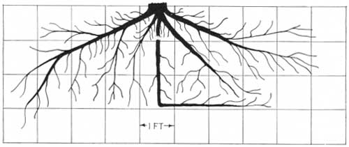
In figure 48, from a drawing of a 50-year-old bur oak root system, the taproot is seen to have developed in somewhat the same manner as that of the tree previously described. It is entirely possible that, with good care, a tree planted in a cycle of subnormal precipitation might find enough moisture to maintain life but would remain shallow-rooted until the seasons became more favorable.
|
| FIGURE 48.—Root system of 50-year-old native codominant bur oak in Lamoure clay loam, McHenry County, N. Dak. Height of tree, 40 feet; diameter breast high, 5.6 inches; vigor, fair; care received during growth, none. Topography, level; subsoil, silty clay loam; zone of lime enrichment, 2.5 to 3.5 feet; depth of water table, about 15 feet. |
Observations show that on encountering the water table the main roots usually end abruptly and send out numerous short, fibrous laterals just above the water line. Figure 49 is from a drawing of the root system of a vigorous 38-year-old cottonwood tree which illustrates this condition. An abundant moisture supply obviated the necessity of a wide-spreading root system.
|
| FIGURE 49.—Root system of 38-year-old codominant cottonwood, planted in windbreak in Sioux sandy loam (sandy subsoil phase), McHenry County, N. Dak. Height of tree, 70 feet; diameter breast high, 10.6 inches; vigor, good; care received during growth, fair. Topography, slight slope, 1 percent; subsoil, coarse sand; zone of lime enrichment, 2.0 to 3.0 feet; depth of water table, 7.0 feet. |
OTHER FACTORS THAT INFLUENCE ROOT HABITS OF TREES AND SHRUBS
Among other factors which appear to have influenced the root development of planted trees are the following:
METHOD OF PLANTING
Trees planted with ample room to place their roots in a normal position make the fastest initial growth and have the best chance of survival. Root systems which had been crowded into small holes and into narrow opening or slits in the ground could, in many instances, especially in fine-textured soils, be readily recognized by their abnormal development.
AGE OF STOCK
A small tree usually withstands transplanting better than a larger one, and its roots are more likely to develop naturally. The more numerous and longer roots of older plants are apt to be cramped into abnormal positions during planting. Extremely small stock, however, is probably not desirable for Plains planting, because very short root systems are more subject to injury when the surface soil becomes dry.
SPACING OF TREES
Closely spaced trees have less lateral root spread than those which are more widely spaced. On the other hand, they have also less crown spread and less leaf surface, factors which reduce the transpiration loss and which must be taken into account in shelterbelt plantings and investigations relating thereto.
TOPOGRAPHY
Trees on rolling or undulating areas of fine-textured soils usually have shallower root systems than those on similar soils of nearly level areas. This difference is probably due to the relative effectiveness of the precipitation in the two localities. The rolling land is more subject to run-off and is not moistened as deeply as the smoother land; consequently there is less stimulus to deep rooting.
CLASS (DOMINANCE IN STAND)
Suppressed and intermediate trees in a stand usually have shallower and less spreading root systems than vigorous dominant and codominant individuals.
DESCRIPTION OF MAJOR SOIL GROUPS
The principal soil types of the shelterbelt zone will now be briefly described by groups which accord with the numbering and locations shown on the maps (figs. 38, 39, and 40). Within each group the soils are fairly uniform in their major features and are about equally well suited to trees. Some of the less extensive soils classed within a given group may differ considerably from those giving character to the group. Several such cases are described which could not be mapped separately on the scale used in this survey. The maps indicate the general characteristics of soils both within and extending for various distances east and west of the shelterbelt zone, the map for the central section being the most extensive. In many cases the descriptions refer to sites which happen to lie well outside the present zone, but which are of interest in relation both to conditions in the zone and to plantings that may be undertaken in the future.
SOILS OF THE NORTHERN SECTION
The following counties in the northern section have been covered in detailed soil surveys and the maps published by the Bureau of Chemistry and Soils: Bottineau, McHenry, Lamoure, Dickey, and parts of Ramsey, Foster, and Stutsman Counties, N. Dak.; and Walworth, Hyde, Douglas, and Brown Counties, S. Dak. A reconnaissance soil map made by the same Bureau covers the western tier of counties within the section across North Dakota and areas adjacent to the zone within Lyman, Gregory, and Tripp Counties, S. Dak. The remainder of the northern section is included within the area covered by reconnaissance soil erosion maps42 made by the Soil Conservation Service during the past year. Free use has been made of all available soil and erosion maps in compiling the present one. Certain soil combinations and separations not shown on the original maps have been made in order to bring out the relationships between soils and trees. The reconnaissance soil maps of western North Dakota and South Dakota and the detail maps covering parts of Ramsey, Foster, and Stutsman Counties, N. Dak., were made prior to 1910. Some of the soil correlations shown on them are not recognized on the present map, which is made to conform to more recent developments in soil classification.
42Without these maps, which were kindly furnished by H. H. Bennett, Director, Soil Conservation Service, U. S. Department of Agriculture, it would have been impossible to complete the present map when needed.
The following groups of soils are recognized and mapped in the northern section (fig. 38):
| Number on map | ||
| Barnes fine-textured soil group | 25 | |
| Includes Barnes loam, silt loam, clay, clay loam, silty clay loam, and very fine sandy loam. | ||
| Barnes and Beadle mixed soil group | 25B | |
| Includes mixture of Barnes and Beadle silt loams. | ||
| Barnes sandy soil group | 26 | |
| Includes Barnes fine sandy loam, sandy loam, and loamy sand. | ||
| Williams fine-textured soil group | 27 | |
| Includes Williams loam, silt loam, clay loam, silty clay loam, and very fine sandy loam. | ||
| Williams sandy soil group | 28 | |
| Includes Williams fine sandy loam, sandy loam, and loamy sand. | ||
| Williams silty soil group (aeolian phase) | 7 | |
| Includes silty soils along Missouri River in northern South Dakota. | ||
| Moody silty soil group | 39 | |
| Includes Moody silt loam. | ||
| Bearden, Tripp, Hall, and Bridgeport soil group | 31 | |
| Only the Bearden and Tripp soils of this group occur in the northern section. | ||
| Boyd and Edgeley clay soil group | 36 | |
| Includes Boyd and Edgeley clay, clay loam, silty clay loam, and loam. | ||
| Beadle claypan soil group | 41 | |
| Includes Beadle silt loam and silty clay loam. | ||
| Aberdeen claypan soil group | 42 | |
| Includes Aberdeen silt loam, silty clay loam, clay loam, and clay. | ||
| Fargo, Rogers, and Maple heavy soil group | 34 | |
| Includes silt loam, silty clay loam, clay loam, and clay types of these soils. | ||
| Pierce gravelly and sandy soil group | 33 | |
| Includes Pierce loams, fine sandy loams, and gravelly loams. | ||
| Sioux sandy soil group | 32 | |
| Includes Sioux loamy sand, loam, fine sandy loam, and sandy loam. | ||
| Valentine and Gannett sandy soil group | 29 | |
| Includes the sand, loamy sand, and fine sandy loam types of these soils. | ||
| Dunesand group | 30 | |
| Includes hilly wind-blown sands. | ||
| Alluvial soils (undifferentiated) | 35 | |
Summarized data pertaining to the groups listed above are given in table 20.
TABLE 20.—General characteristics of soils of the northern section of the Shelterbelt Zone (North Dakota and South Dakota)
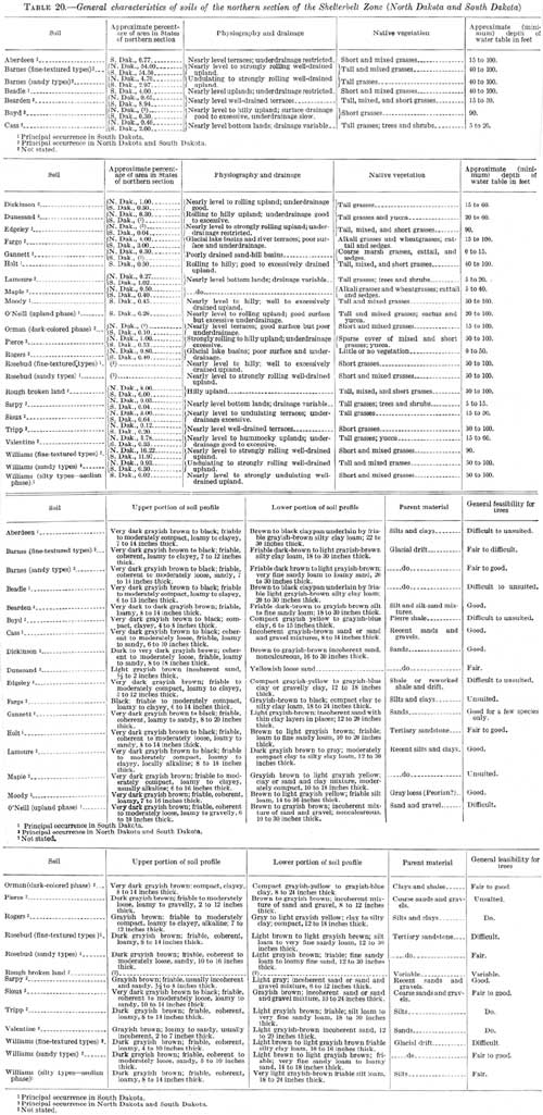
(click on image for a PDF version)
BARNES FINE-TEXTURED SOIL GROUP
The soils of the Barnes fine-textured soil group (fig. 50) are among the most extensive in the northern section. Their topsoils include a variety of textures but range mostly between silt loams and loams, there being no large areas in which they are sandy. The subsoils are composed largely of silt or silty clay. The entire soil is friable. These soils have developed under tall, sod-forming grasses. They have accumulated large amounts of black, well-decomposed grass remains, and are almost black to depths ranging from 7 to 12 inches. The subsoils are brown in the upper part and almost white in the lower. They have a well-developed zone of lime enrichment which lies at depths ranging from 12 to 24 inches and often contains as much as 8 percent of calcium carbonate. These soils have developed from unconsolidated, light-colored limy drift which usually lies at a depth of about 40 inches. The drift is extremely variable in texture but generally contains considerable amounts of coarse material, including gravel and boulders of various sizes, mixed with the more abundant silt and clay constituents.
|
| FIGURE 50.—Profile of one of the fine-textured Barnes soils of Dickey County, N. Dak. This soil differs from the Williams soil chiefly in that it has a darker topsoil; it has developed under a higher rainfall. Most trees do well on the soils of this group. |
The surface ranges from nearly level to hilly, the rougher areas occurring along the lines of glacial moraines where part of the land is too rough or too stony for cultivation. Surface and underdrainage is everywhere good. Some sheet erosion occurs on the steeper slopes where unprotected by vegetation.
The soils of this group have high moisture-holding power and where not too rough or stony for cultivation, are the most productive farming soils of the uplands. The water table, except in local areas, lies at depths exceeding 50 feet.
Nearly all trees commonly planted in the uplands of the Dakotas occur in one locality or another on the fine-textured Barnes soils. Most of the trees, however, root shallower, are a little more stunted and have a higher mortality than trees on the sandier Barnes soils. Cottonwood, willow, and boxelder show the highest mortality. Practically all of the golden willows have succumbed to drought on the soils of this group, especially in localities where the topsoils are shallow. Few of the cottonwood and boxelder more than 30 years old are alive.
Among the trees which seem to do best on the fine-textured Barnes soils are green ash, hackberry, Russian-olive, caragana, dwarf Asiatic elm, choke cherry, cedar, wild plum, and buckthorn.
In the Turtle Mountain section of Bottineau and Rolette Counties, N. D., the soils of this group are supporting thrifty stands of bur oak, aspen, American elm, paper birch, green ash, and willow trees. The heavy growth here is probably due to unusually favorable moisture conditions rather than to any feature of the soils.
BARNES SANDY SOIL GROUP
The soils of the Barnes sandy soil group (figs. 51 and 52) occur in close association with those of the Barnes fine-textured group, from which they differ only in that their topsoils and subsoils are more sandy. Most of them contain sufficient silt and clay mixed with the sand to give the soil material good "body" and high water-holding powers. They have developed from sandy glacial deposits and are much less extensive than the soils of the Barnes fine-textured group. In places they can be distinguished from the Valentine soils only by their higher lime content.
|
| FIGURE 51.—Barnes fine sandy loam on an extensive flat area 4 miles east of Forestburg, S. Dak., underlain by water table at no great depth. Excellent shelterbelts, chiefly of cottonwood, occur frequently over this flat. Field in foreground left fallow in 1934 and protected from blowing by weed growth (Russian thistles). Compare with figure 52. (F296016) |
|
| FIGURE 52.—Barnes fine sandy loam, under exactly the same conditions as shown in figure 51, illustrating the urgent need for shelterbelt planting on all such sandy soils in the Plains to protect them from complete destruction by wind. Dunes or drifts of soil from 1 to 3 feet in depth, such as seen in the foreground, are collected by the presence of a few weeds. (F250017) |
Most trees commonly planted in the uplands throughout the Dakotas do well on these soils.
WILLIAMS FINE-TEXTURED SOIL GROUP
The soils of the fine-textured Williams group (fig. 53) are characterized by dark-brown silty or loamy topsoils, 4 to 10 inches thick, and buff or almost white silty clay subsoils which rest at depths of 18 to 24 inches on unweathered limy drift. These soils occur on well-drained, undulating to hilly uplands and are friable throughout. They are distinguished from the fine-textured Barnes soils by their slightly thinner and lighter colored surface layers and by the shallower depths of their entire soil section. They occupy most of the western part of the shelterbelt zone in the Dakotas, where they support mixed short and tall grasses.
|
| FIGURE 53.—Profile of one of the fine-textured Williams soils, developed under rather arid conditions within the Altamont Moraine territory in western Wells County, N. Dak. The zone of lime concentration, with numerous small concretions, is plainly visible. Such soils must be planted to exceptionally drought-resistant shelterbelt species. (F259492) |
Owing to their rather fine texture and to the low precipitation of the region in which they occur, these soils are low in moisture. They are not as well suited for trees as the finer textured soils farther east or the sandy upland soils in either the eastern or western parts of the northern shelterbelt section. A large percentage of the trees planted on them have died during the recent prolonged drought. Exceptionally drought-resistant species such as caragana, green ash, hackberry, Russian-olive, choke cherry, and cedar, although rather stunted, have survived fairly well.
WILLIAMS SANDY SOIL GROUP
Soils mapped with the Williams sandy soil group are more sandy in both topsoil and subsoil than those of the Williams fine-textured group but are otherwise very similar to those soils and occur in close association with them. They resemble the sandy Barnes soils except that they have slightly thinner and lighter colored topsoils.
These soils are among the better tree soils of the uplands in the western part of the shelterbelt zone. Trees growing on them are not quite so thrifty as those on the sandy Barnes soils farther east, owing to a decrease in the precipitation westward, but are usually more thrifty than those on any of the fine-textured soils of either the Barnes or Williams groups. Few of the hardier native or planted trees have succumbed to the drought on the soils of this group (figs. 36 and 54).
|
| FIGURE 54.—Williams stony loam on Altamont Moraine south of Goldwin. N. Dak. This soil is rather porous. The shrubbery, buckbrush, and silverberry in foreground indicates that it is probably suited to trees. |
WILLIAMS SILTY SOIL GROUP (AEOLIAN PHASE)
The soils of the Williams silty soil group occupy a few large areas east of Missouri River in South Dakota. They have developed from light-colored loess or floury silt which thinly covers the glacial drift. The topsoils are brown to dark brown, and the subsoils, which are very limy, are light grayish yellow or almost white. The soils and parent material are friable.
These soils, except for the slightly lighter color of their topsoils, are identical with the friable loess-derived soils of southwestern Nebraska. In common with most soils developed from loess in the shelterbelt zone, they absorb water rather rapidly and have high moisture-holding capacities. They are more moist or drought resistant than any of those in the Williams fine-textured group and are more deeply penetrated by roots. Trees growing on them have survived the drought remarkably well, considering the low precipitation. Even cottonwood, which is poorly suited for most of the fine-textured upland soils in the western half of the zone, shows fairly good growth and survival. Ash, red cedar, ponderosa pine, Russian-olive, caragana, choke cherry, and honeylocust are all doing well on them.
MOODY SILTY SOIL GROUP
Soils belonging to the Moody silty soil group occupy only a few small bodies in the southern part of the northern section. They are described in connection with the central section, where they occur more extensively.
BEARDEN, TRIPP HALL, AND BRIDGEPORT SOIL GROUP
Only the Bearden and Tripp soils of this group occur in the northern section, where they occupy outwash flats and benches within the glaciated area. These soils are among the most productive farming soils in the Dakotas. They have thick topsoils which in the Bearden are very dark, often almost black, and in the Tripp are dark brown or chestnut brown in color. The topsoils have a wide textural range, but few of them contain sufficient amounts of coarse material to be droughty or of clay to prevent rapid water absorption. The subsoils are light colored and very limy. They range in texture from silts to fine sandy loams. These soils are friable throughout and have high moisture-holding powers. All of them have good surface and underdrainage. The water table lies within shallow depths in places.
For establishing successful groves, the soils of this group are among the best in the Dakotas. Fifty-year-old green ash trees, in good groves, have attained a maximum height of 70 and an average of 55 feet. Most trees on these soils are vigorous and have survived the severe drought remarkably well.
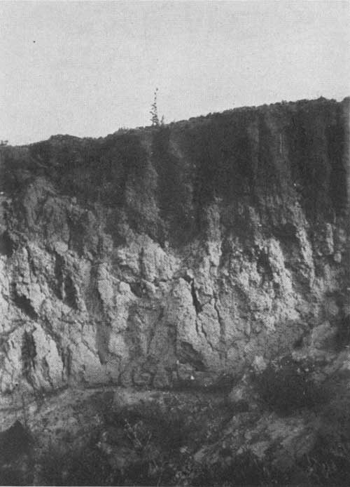
BOYD AND EDGELEY CLAY SOIL GROUP
The Boyd and Edgeley group (figs. 55 and 56), includes soils which have developed from dense bluish and grayish Pierre shales or from mixtures of drift and shale in which the latter material predominates. The largest developments within or near the shelterbelt zone are on the rolling uplands in Lyman, Gregory, and Tripp Counties, S. Dak., and in the Missouri River breaks. The soils occur locally in some of the northern Nebraska counties.
|
| FIGURE 55.—Boyd clay loam on the slightly dissected Missouri Plateau about 30 miles west of Pierre. S. Dak. The soil is locally known as "black gumbo", and the native sod here is largely grama grass. Shelterbelt establishment on this soil type will be exceedingly difficult because of the slow rate at which water is absorbed. (F289977) |
|
| FIGURE 56.—Rough type of Boyd clay loam, derived from the Pierre shale, at the mouth of White River a few miles south of Chamberlain, S. Dak. Such land is included in rough broken areas on the map (figs. 38-40). (F289979) |
The topsoils are very dark brown or almost black except where erosion has been unusually severe. They range in texture from clays to loams and are rather shallow, as the dense clay does not lend itself readily to weathering. The subsoils which lie at depths ranging from 6 to 14 inches, are composed mainly of clay and are extremely compact. The unweathered shale usually is within a 3-foot depth, even on the smoother areas. It outcrops in all eroded situations. The soils are often limy at the surface.
The Boyd and Edgeley soils probably have higher water-holding capacities than any of the other soils in the northern section, but owing to their extremely clayey nature absorb moisture very slowly. Most of the precipitation falling on them evaporates or runs off the land before it can be utilized by plants. In years of high and frequent rainfall these soils are very productive. In dry years the clay, of which they are so largely composed, becomes extremely dry, shrinks, and cracks, and leaves the soils very droughty.
Only a few groves, consisting mostly of green ash or honeylocust and scattered American elm, Russian-olive, and red cedar trees, were observed on these soils. Most of the trees are short and scrubby and in some of the groves 70 to 90 percent of them are dead. Red cedar and Russian-olive seem to have withstood the drought much better than the others. Dwarf Asiatic elm and caragana would probably do well, although neither species was observed. Considering the heavy nature and droughty character of these soils, shelterbelt planting on a large scale should not be attempted on them.
Associated with the Boyd and Edgeley soils but not located on the map are a few narrow terrace developments of Orman soils. These have developed from water-transported Pierre shale and are almost identical in all soil features to the Boyd, but owing to their lower topographic position are not quite as droughty. In places they support scattered native ash, hackberry, American elm, cottonwood, boxelder, and red cedar trees, which seem to have withstood the drought fairly well.
BEADLE CLAYPAN SOIL GROUP
Beadle silt loam occupies the greater part of the Beadle claypan soil group. It is found in nearly level undissected upland situations within areas of fine-textured Barnes soils. The most uniform bodies are in Beadle, Spink, Clark, and a few other counties of South Dakota. They are designated on the map by the number 41. Less uniform bodies, namely those in which the soil occupies numerous small patches within areas of Barnes soils are designated by the symbol (25B).
Beadle silt loam differs from the soils of the Barnes fine-textured group chiefly in that it has a much heavier and more compact upper subsoil layer. The top-soil, which is composed largely of silt, is friable and very dark brown or almost black. It rests at an average depth of 10 inches upon very dark brown, dense clay ranging in thickness from 4 to 12 inches. The dense layer, which is a true claypan, is underlain by friable limy and often alkaline silty clay. The silty clay is light-colored but is more or less splotched with rusty-brown stains indicating poor drainage. It contains gypsum in places.
Areas of this soil are not well suited to trees, probably owing to poor aeration beneath the claypan layer. Most of the trees observed are dead or dying, and practically all of them are shorter and less vigorous than on adjacent soil types. Even such hardy trees as green ash show serious decadence on Beadle soil after 25 to 30 years, whereas the same species remain quite vigorous for 40 to 50 years on the more friable associated soils. On the basis of present knowledge. it does not seem advisable to plant extensively on the Beadle soil.
ABERDEEN CLAYPAN SOIL GROUP
The Aberdeen claypan soil group as mapped includes the silt loam and silty clay loam types of the Aberdeen soils, which are chiefly in the dry bed of glacial Lake Dakota. These soils are identical in all features with the Beadle soils but occupy terrace positions, whereas the Beadle is on the uplands. They have almost black topsoils and dense claypan upper subsoils which overlie friable limy silt or silty clay.
Although the soils of this group have a claypan, they do not seem to be as inimical to trees as Beadle soil. Hurried field observations indicate that a few trees can be grown on them with moderate success, but that the choice of suitable species will be rather limited. In South Dakota the soils are supporting a few fairly good windbreaks of green ash, caragana, boxelder, and Russian-olive. The longevity and height of most trees on the Aberdeen soils are intermediate between those of trees on the Beadle and Barnes soils. Green ash in well-tended groves remains vigorous for about 50 years, but the trees average only about 30 to 35 feet in height at that age. Cottonwood makes good initial growth on the Aberdeen but becomes decadent when about 30 years old.
FARGO, ROGERS, AND MAPLE HEAVY SOIL GROUP
The soils of the Fargo, Rogers, and Maple heavy soil group occupy numerous poorly drained basins within areas of the finer textured upland and terrace soils in the Dakotas. Only the largest developments within the shelterbelt zone are shown on the map. These soils are periodically covered with water, often for several weeks. They are composed largely of clay to depths exceeding 3 or 4 feet. When the water evaporates from the basins the clay dries, shrinks, and cracks badly, and the soils become extremely droughty.
Fargo soils occupy most of the basins. They have deep, almost black topsoils composed largely of silt or clay. The subsoils are gray, very dark brown, or splotched gray and brown, and are very heavy although not true claypans. The soils are limy below a depth of 2 or 3 feet and in numerous places are calcareous at the surface. They seldom contain injurious amounts of alkali.
The Maple soils resemble the Fargo in most features but have thinner topsoils and lighter, often almost white, subsoils. They are alkaline. The Rogers soils have light-colored topsoils and are very alkaline. They occupy only a few of the basins (fig. 57).
|
| FIGURE 57.—Rogers clay loam in partially dry lake bed, north of Turtle Lake, McLean County, N. Dak. The Rogers soils are highly alkaline. The soil around the margin of the water in the background is covered with white alkali, chiefly CaSO4. |
Practically none of the soils of this group is suited to trees. Patches of the Fargo soils support plantings of cottonwood, green ash, caragana, and boxelder in localities where the moisture supply is unusually favorable, but the soils of the group as a whole are tree less. The Rogers soils support practically no vegetation.
PIERCE GRAVELLY AND SANDY SOIL GROUP
Pierce gravelly and sandy soils occur in widely scattered and usually small areas throughout the glaciated parts of the Dakotas. Only the larger areas are shown on the accompanying map.
These soils occupy gravel-covered knobs and ridges. They have thin though fairly dark-colored topsoils ranging in texture from loams to coarse gravelly loams. The subsoils in most places are composed of large and small water-worn stones mixed with an abundance of fine gravel and coarse sand but locally may consist almost entirely of sand (fig. 58).
|
| FIGURE 58.—Profile of Pierce gravelly loam; Kidder County, N. Dak. The Pierce soils differ from the Sioux chiefly in that they have thinner topsoils. They occur in the uplands, whereas the Sioux occupy terraces, and are very droughty. |
Owing to their high-gravel content, the soils of this group, as a whole, have very low moisture-holding powers and are unable to support satisfactory trees. The few localities in which the subsoils are sandy are fairly well suited to some of the hardier trees and shrubs.
SIOUX SANDY SOIL GROUP
The soils of the Sioux sandy soil group (figs. 59 and 60) are on the more sandy or gravelly outwash flats and benches within the glaciated part of the Dakotas. They have dark and often rather thick top-soils, which range widely in texture but usually contain more sand or gravel than fine material. The subsoils may consist of sand, gravel, or a mixture of the two. They are very limy. The water table is at shallow depths in many places.
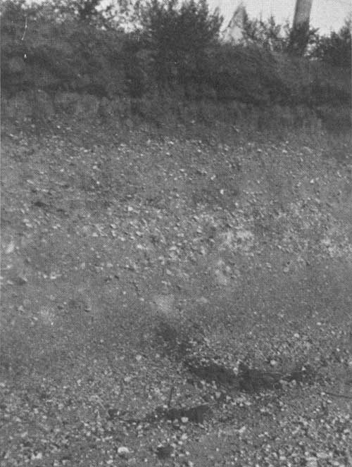
|
| FIGURE 59.—Profile of Sioux fine sandy loam; Kidder County, N. Dak. |
|
| FIGURE 60.—Field of Sioux sandy loam, showing accumulations of wind-blown sand around clumps of sandgrass. This field, about 10 miles southwest of Towner, N. Dak., has been practically ruined by wind erosion. Trees do poorly in localities where subsoil and substratum consist of coarse gravel to great depths. |
These soils, as a whole, are well suited to trees. Cottonwoods thrive where the water table is within 10 feet of the surface, often attaining a height of 60 or 70 feet in about 30 years. The only localities where trees do poorly are those in which the subsoil and substratum consist of coarse, dry gravel to great depths.
VALENTINE AND GANNETT SANDY SOIL GROUP
The Valentine and Gannett soils occur in extremely sandy areas having a strongly rolling or choppy surface (fig. 61). Usually the water table is within a depth of 10 feet. The largest developments of these soils, in the northern section, are in the Lake Souris Basin of Bottineau and McHenry Counties, N. Dak., and just outside the basin to the southeast. The Valentine soils, which occupy the higher and better-drained situations, are the more extensive. They have accumulated only small amounts of organic matter and have thin, brownish topsoils. The Gannett soils are in low, poorly drained pockets and swales where the grass growth is most luxuriant and decay is relatively rapid. Their topsoils are deep and almost black.
|
| FIGURE 61.—Valentine fine sand with a more or less general natural cover of aspen; Richland County, N. Dak. The Valentine soils differ from dune sand chiefly in topography—they are not hilly. These soils often support small patches of natural tree growth. (F250035) |
The Sioux soils have dark topsoils underlain by porous gravelly and limy subsoils. They are droughty except where underlain by high water tables.
The subsoil in both Valentine and Gannett types usually consists of gray, incoherent fine to medium sand, which in the former is very low in lime and in the ]atter is highly calcareous. Some of the Gannett soils contain thin clay layers and are water-logged a part of each year. Locally they may be alkaline.
These soils support a natural growth of aspen and willow, and in several places planted groves of cottonwood. The Valentine soils are well suited to a variety of trees in addition to those mentioned, including hackberry, boxelder, Russian-olive, American elm, choke cherry, wild plum, red cedar, and ponderosa pine.
The Gannett soils are a little too moist during average years for most tree species except cottonwood and willow.
DUNE-SAND GROUP
There are numerous small bodies of dune sand in the northern section, but few, if any, are sufficiently large to warrant showing on a map of the scale used in this survey. One of these is in the extreme northeast Corner of Brown County, S. Dak. Most of the bodies not shown on the map are associated with areas of Valentine soils. A few lie within sandy Barnes soil areas, as in the vicinity of Forestburg and Mound City, S. Dak., and south of Bergen, N. Dak.
Dune sand includes areas in which the wind has piled loose sand into high hills and ridges. The material differs from Valentine soils only in that it has a rougher surface and less topsoil. It is composed of gray, fine to medium sand from the surface downward. At present a negligible part of the dune sand is subject to active wind erosion because its native grass cover is good. The material is not calcareous.
Dune sand seems to have an adequate available moisture supply and is remarkably drought-resistant considering its loose, open structure. It supports in many places a natural growth of choke cherry, hack-berry, boxelder, American elm, bur oak, and aspen (fig. 62).
|
| FIGURE 62.—Dune sand within the basin of old Lake Souris, McHenry County, N. Dak., bearing a natural forest of bur oak, elm, and hackberry. This illustrates the much more favorable conditions for forest and shelterbelt planting on sand in the northern portion of the shelterbelt zone as compared with the southern portion, where light sands become very droughty. (F250000) |
ALLUVIAL SOILS UNDIFFERENTIATED
The undifferentiated alluvial soils have developed from sediments recently washed from the uplands and deposited on the flood plains along streams. They consist chiefly of various types of Lamoure soils, but include small amounts of Cass and Sarpy soils.
The Lamoure soils have formed from the finer textured sediments. They have deep, almost black topsoils, ranging in texture from clay loams to fine sandy loams. The subsoils, which consist largely of silt or a mixture of silt and clay, are light-colored and very limy. They frequently contain rusty brown splotches and streaks caused by imperfect drainage.
The Cass and Sarpy soils have developed from the coarser stream sediments and have sandy or gravelly subsoils. The Cass soils have accumulated considerable amounts of organic matter and have developed dark topsoils. The Sarpy soils are light-colored from the surface downward.
All the soils mapped with this group are subirrigated, the water table frequently lying within 6 or 8 feet of the ground surface. They are well suited to most trees commonly grown in the Dakotas. Native forests composed largely of boxelder, willow, and cottonwood occur on many of them.
ROUGH BROKEN AREAS
Areas of rough, broken land in the different soil groups are indicated on the soil map by diagonal cross-hatching. There is considerable variation in the relief within these areas, especially in those occupied by soils of the Boyd (fig. 55) and Edgeley group just east of the Missouri River in Hughes County, S. Dak., and in Emmons and Burleigh Counties, N. Dak. Here much of the land adjoining the river breaks is rolling, but since it is occupied by soils which are relatively poor for trees, it is included in this survey with rough and broken land. Aside from these rolling areas, the rough, broken land mapped in the northern section consists mainly of boulder-covered morainic hills and ridges within areas of the Barnes and Williams soils (figs. 51-54), and of severely eroded areas in stream valleys. More of the morainic areas might have been mapped as rough, so far as their usefulness for cultivation is concerned.
Except for local patches and part of the rolling areas previously mentioned, the rough, broken land is used for grazing purposes. It is practically devoid of trees, although clumps of choke cherry, green ash, buffalo-berry, red haw, and wild plum occur locally in pockets on the Pierre slopes along the Missouri River.
SOILS OF THE CENTRAL SECTION
Most of the central section of the proposed shelterbelt zone was mapped prior to 1912 in reconnaissance soil surveys43 that include the western parts of South Dakota, Nebraska, and Kansas. Practically all of the Nebraska counties within the section are mapped in detailed soil surveys.43 In addition, the section as a whole is covered by reconnaissance soil-erosion surveys44 made during the past year. Data from each of these surveys were used in compiling the present map of the central section, and because of their availability and the very pertinent soil facts that they record, this map has been extended far beyond the shelterbelt zone in Nebraska and Kansas. As in the northern section, soil combinations and correlations not appearing on the original maps have been made on the present draft.
43Bureau of Chemistry and Soils.
44Soil Conservation Service.
The following groups of soils are shown on the map of the central section (fig. 39):
| Number on map | ||
| Rosebud fine-textured soil group | 37 | |
| Includes Rosebud silt loam, very fine sandy loam, and loam. | ||
| Rosebud sandy soil group | 38 | |
| Includes Rosebud fine sandy loam and loamy sand. | ||
| Holt sandy soil group | 45 | |
| Includes Holt sandy loam, fine sandy loam, gravelly sandy loam, and loamy sand. | ||
| Dunlap and Dawes fine-textured soil group | 49 | |
| Includes all textures of these soils. | ||
| Epping fine-textured soil group | 50 | |
| Includes all textures of these soils. | ||
| Pierre heavy soil group | 44 | |
| Includes all textures of Pierre and Orman soils. | ||
| Dickinson and upland O'Neill sandy soil group | 51 | |
| Includes all textures of these soils. | ||
| O'Neill sandy soil group | 46 | |
| Includes sandy soils on terraces. | ||
| Prairie-Plains soil group | 43 | |
| Includes intricate mixture of Cass and Valentine soils and dune sand. | ||
| Bearden, Tripp, Hall, and Bridgeport soil group | 31 | |
| Includes friable fine-textured soils on terraces. | ||
| Hoidrege and Hastings silty soil group | 47 | |
| Includes all textures of Holdrege and Hastings soils. | ||
| Colby silty soil group | 16 | |
| Includes all textures of these soils. | ||
| Crete and Grundy claypan soil group | 21 | |
| Includes all textures of these soils. | ||
| Scott claypan soil group | 17 | |
| Includes Scott, Butler, and Fillmore soils. | 17 | |
| Moody silty soil group | 39 | |
| Includes all textures of these soils. | ||
| Soils of loess tables and canyons | 48 | |
| Include Colby, Holdrege, and Hastings soils intimately associated with their eroded phases. | ||
| Dune-sand group | 30 | |
| Includes dune sand and small bodies of Valentine and Gannett Soils. | ||
| Valentine, Anselmo, and Gannett sandy soil group | 20 | |
| Includes all textures of these soils. | ||
| Alluvial soils (undifferentiated) | 35 | |
Summarized data pertaining to the above groups are given in table 21.
TABLE 21.—General characteristics of soils of the central section of the Shelterbelt Zone (Nebraska and Kansas)
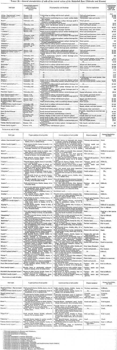
(click on image for a PDF version)
ROSEBUD FINE-TEXTURED SOIL GROUP
Areas in which the soils are composed chiefly of Rosebud silt loam, very fine sandy loam, or loam types are included in the Rosebud fine-textured soil group. These soils have developed from loosely cemented and very limy sandstone of Tertiary age. They are most extensive in northwestern Nebraska, where they cover the greater part of the nearly level to gently rolling and higher lying uplands. They also occupy rather large areas in several of the southwestern counties of Nebraska. All of them have formed under a short-grass cover.
The topsoils are brown to dark brown, range in thickness from 7 to 10 inches, and are composed largely of silt or mixtures of silt and the finer grades of sand. The subsoils are light grayish yellow and very limy. They consist mainly of silt, although they frequently contain enough sand to give them a gritty feel. The entire soil section is friable.
The fine-textured Rosebud soils have good water-holding powers but do not absorb as much of the precipitation as soils with a higher sand content. In dry years crops growing on them usually suffer more from drought than those growing on the more sandy Rosebud soils.
Only a few plantings of green ash, caragana, American elm, and boxelder were observed on these soils. Few of the trees exceed 20 feet in height, although many of them are more than 40 years old. A large percentage of them are dead or dying. The soils of this group are of doubtful value for shelterbelt planting on any large scale.
ROSEBUD SANDY SOIL GROUP
Most of the soils of the Rosebud sandy soil group surround or adjoin areas of Valentine soils and dune sand. The largest developments are in western Nebraska and northwestern Kansas. The topsoils consist of brown fine sandy loams to loamy fine sands. The subsoils, which are very light colored and highly calcareous, usually contain less sand and more silt than the topsoils. They rest at depths of 2 or 3 feet upon the soft limy sandstone from which the soils have developed. The high sand content of these soils is due in many places to admixtures of wind-blown sand from Valentine soils and dune-sand areas. In some of the soils of this group the surface layers are so sandy that they become unstable if the protective vegetation is destroyed.
Although occurring in a rather dry region, these soils are able to absorb practically all the precipitation. Their subsoils have high moisture-holding power, and most of the moisture absorbed is available to the vegetation. Even light rains are able to replenish the moisture supply appreciably, thus enabling the native grasses to remain green much longer during droughts than on the finer Rosebud soils.
The soils of this group are superior to the fine-textured Rosebud soils for trees. Scattered plantings of American elm, green ash, ponderosa pine, and honeylocust are making fairly good growth. Most of the trees are vigorous. Russian-olive and red cedar, although not observed on these soils, are probably well suited to them. All species would undoubtedly be more difficult to establish, especially during dry years, and would make slower growth here than on sandy soils farther east. Carefully selected species should survive well, however, provided they are given reasonable care.
HOLT SANDY SOIL GROUP
The soils of the Holt sandy soil group (fig. 63) are identical in texture with those of the Rosebud sandy soil group and in common with those soils have developed from loosely cemented calcareous sandstone. They lie farther east, however, in a region of higher rainfall and more luxuriant grass growth and have developed deeper and darker surface layers. All of them have highly calcareous subsoils.
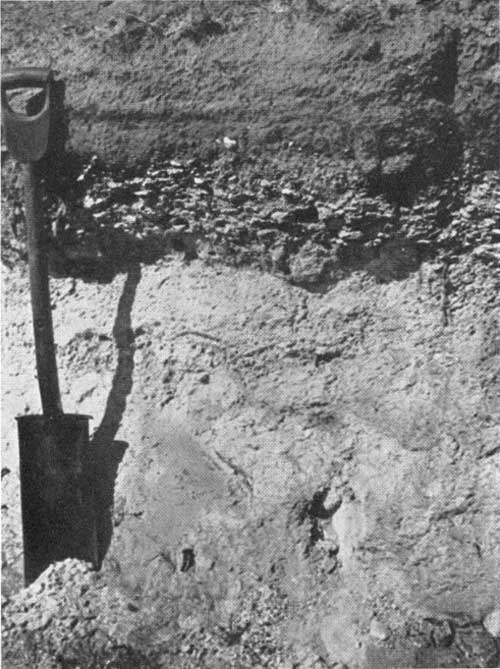
|
| FIGURE 63.—Profile of one of the finer textured Holt soils, Holt very fine sandy loam; Brown County, Nebr. The Holt soils differ from the Rosebud chiefly in that they have darker colored topsoils. They have developed from limy Tertiary sandstones. These soils are well adapted to a wide variety of trees and shrubs. |
These soils absorb moisture rapidly, have high water-holding capacities, and are well adapted to a variety of trees and shrubs, including honeylocust, red cedar, ponderosa pine, American elm, Russian-olive, green ash, choke cherry, and wild plum.
DUNLAP AND DAWES FINE-TEXTURED SOIL GROUP
The Dunlap and Dawes fine-textured soils occur in large and small bodies within areas of Rosebud soils throughout western Nebraska. They usually are in nearly level situations on the higher lying parts of the uplands, although the Dawes may be on long gradual slopes. Their topsoils are friable, are brown to dark brown, and are 10 to 14 inches thick. They range from silt loams to fine sandy loams, the silty textures predominating. The upper subsoils consist of moderately heavy, brown to very dark brown silty clay loam, 8 to 24 inches or more in thickness; those in the Dawes are thinner but darker and denser than those in the Dunlap and usually have a thin grayish subsurface layer which is not present in the Dunlap. The lower subsoils are composed of floury light-colored and limy silt, which rests on parent limy sandstone or on mixtures of sand and clay at a depth of 4 or 5 feet.
These soils have high water-holding capacities, but owing to their rather heavy character are unable to absorb much moisture from the light precipitation. Even during seasons of normal precipitation water does not often penetrate beyond the base of the upper subsoil layer. In dry years the topsoils are seldom wetted for their entire depth.
A few groves and scattered trees, chiefly ash, have been planted on some of the soils of this group. The majority of the trees observed are surviving fairly well, but all of them are short and scrubby.
EPPING FINE-TEXTURED SOIL GROUP
The Epping fine-textured soil group (fig. 64) occupies a few large areas in northwestern Nebraska. The soils are immature. Their topsoils are gray to light grayish brown and range between silt loams and fine sandy loams, the finer textures predominating. They seldom exceed 6 or 8 inches in thickness and usually rest directly upon the parent material, a pale flesh-colored or white clay belonging to the white river beds of Tertiary age.
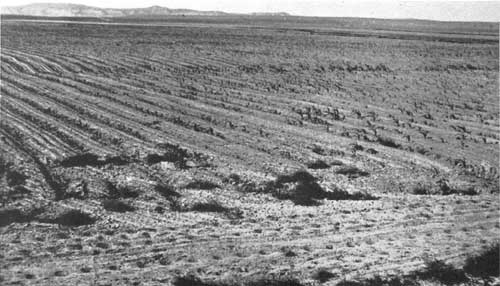
|
| FIGURE 64.—One of the few areas of uneroded Epping soils, showing the light color of topsoil; Banner County, Nebr. The Epping soils are normally unsuited to the growth of any but highly drought-resistant trees. |
Nearly all the Epping soils are rather steeply sloping. In numerous places the parent material is exposed and in local spots has been eroded into a badland topography.
The soils absorb moisture too slowly to support good vegetative growth in this region. They permit excessive water loss through run-off and remain rather droughty even during seasons of normal precipitation. Practically the entire area occupied by them is in pasture land. They are unsuited to trees, except very hardy and drought-resistant species, such as red cedar.
PIERRE HEAVY SOIL GROUP
This Pierre heavy soil group includes the Pierre and Orman soils of northwestern Nebraska. The soils have developed from the heavy Pierre shale formation and are similar in subsoil features to those of the Boyd and Edgeley clay soil group farther east but have lighter colored, thinner, and more limy topsoils.
The Pierre soils are on undulating to rolling uplands, whereas the Orman occupy narrow broken strips on stream terraces. The two are similar in profile features.
The topsoils consist of light-brown or grayish-brown clay or clay loam which rests on dense subsoil clay, usually within a 6-inch depth. The parent shale seldom lies more than 2 feet beneath the ground surface in the Pierre soils, but the substratum beneath the Orman consists of water-transported clays which may be several feet thick. The soils of this group are very limy from the surface downward and somewhat alkaline.
Owing to their high clay content, the Pierre and Orman soils absorb the precipitation very slowly and, in the rather dry region of their occurrence, are droughty. They support a sparse cover of bluestem and grama grasses. The Pierre soils are practically treeless. Narrow broken strips of native vegetation, including ash, cottonwood, American elm, hackberry, and boxelder, occur on the Orman soils, especially along drainage ways, where the subsoil drainage is good.
DICKINSON AND UPLAND O'NEILL SANDY SOIL GROUP
The Dickinson and upland O'Neill sandy soil group as mapped includes areas of nearly level to gently rolling uplands on which Dickinson and upland O'Neill soils are so intricately mixed that the individual bodies of each cannot be indicated legibly on the map. The soil mixture occupies rather large areas in the northeastern part of the central section, chiefly in Holt, Rock, Brown, and Keyapaha Counties, Nebr.
The upland O'Neill and the Dickinson soils are similar in that both have very dark topsoils and noncalcareous subsoils. Otherwise they differ greatly. The former are composed largely of gravel or mixtures of coarse sand and gravel and have rather shallow topsoils, whereas the latter consist mainly of fine or medium sands and have deep topsoils. These soils are about equally extensive in most of the areas where the group is mapped.
They absorb practically all precipitation as rapidly as it falls, but the Dickinson soils have higher moisture-holding powers and, as a whole, are more drought-resistant than the upland O'Neill, especially for crops. On the Dickinson soils most tree species commonly grown on the uplands of northern Nebraska do well, including green ash, hackberry, American elm, dwarf Asiatic elm, honeylocust, Russian-olive, choke cherry, mulberry, red cedar, and ponderosa pine.
Trees are difficult to establish on the upland O'Neill soils, and during the first few years many of them die owing to the droughty nature of the subsoil. As the roots extend downward, however, they are able to reach a ground-water moisture supply in some places. In general, the trees on the upland O'Neill soils are not as vigorous as those on the Dickinson soils, and the species which can be used successfully are more limited.
O'NEILL SANDY SOIL GROUP
The O'Neill sandy soil group includes all the sandy soils of the terraces in the central section that are in bodies of sufficient size to be indicated on the map. The group consists chiefly of the O'Neill, although it includes small patches of Sparta and Plainfield soils.
The O'Neill soils are characterized by deep, dark-colored topsoils ranging in texture from fine sandy loams to loamy sands. Their subsoils are composed largely of sand but contain considerable gravel in places. These soils are practically lime free. The Sparta and Plainfield soils, which are much alike, differ from the O'Neill only in having lighter colored and thinner topsoils.
The soils of this group have nearly level to gently undulating surfaces and are well drained. In places where gravel is especially abundant the underdrainage is excessive, and the soils are rather droughty, especially for farm crops. All of the sandy soils of the terraces, however, are favorably situated to receive run-off from higher levels, which gives them a greater moisture supply than occurs in upland soils of comparable texture. In many places they are subirrigated at depths within the reach of tree roots.
The group as a whole is well suited to a variety of trees and shrubs, including American elm, green ash, hackberry, honeylocust, boxelder, black walnut, Russian-olive, mulberry, choke cherry, wild plum, and red cedar. Cottonwood makes excellent height growth where the water table is within 10 or 12 feet of the surface.
PRAIRIE-PLAINS SOIL GROUP
The prairie plains of northeast Nebraska are occupied by an intricate mixture of sandy soils. Cass soils are the most extensive, but the area includes numerous small bodies of Valentine and Dickinson soils and dune sand.
The large prairie-plains area has many of the features of sandy bottom lands but is much larger than would seem possible were it formed by its present drainage system. A few permanently flowing streams occur in it, but they are small. Seepage from the vast sand-hill region to the west maintains the water table constantly within a depth of 4 or 5 feet in the Cass soils, and during the spring the water rises sufficiently to produce marshy spots. The other soils of the group have good surface and underdrainage, but the water table, except in dune sand, is nearly everywhere within a 20-foot depth. In the eastern part of the area the Cass soils are fairly continuous, covering in places entire townships within which the local relief seldom exceeds 5 feet. Westward these soils follow an intricate system of narrow lowland strips surrounding slightly elevated bodies of Dickinson and Valentine soils, or high hills and ridges of dune sand.
The soils of this group are extremely sandy from the surface downward. The Cass and Dickinson types have accumulated an abundance of organic matter and have thick, dark topsoils. Dune sand and the Valentine soils are low in organic matter and rather light colored even at the surface.
Planted groves and trees are more numerous in the prairie-plains area of Nebraska than in any other area of equal size in the proposed shelterbelt zone. Cottonwood trees comprise the bulk of the plantings, most of which are on the Cass soils. Numerous plantings are on the Valentine and Dickinson soils, however, and a few are on dune sand. On the Cass soils, cottonwood attains an average height of 60 to 80 feet in 30 or 40 years. Some of the green ash trees growing on these soils are 60 feet high. Willows thrive in many places. Russian mulberry, red cedar, American elm, Russian-olive, honeylocust, and choke cherry do well on most soils of the group. Catalpa is good, particularly on the heavier soils. Volunteer seedlings of red cedar are found in several localities.
BEARDEN, TRIPP, HALL, AND BRIDGEPORT SOILS GROUP
All soils of the Bearden, Tripp, Hall, and Bridgeport soils group are in the central section. The Bearden and Tripp, which occur also in the northern section, have been previously described. Since all soils of the group are fairly similar in their features and adaptabilities to trees, only those characteristics which apply to the group as a whole will be mentioned here.
The soils are on nearly level to gently undulating and well-drained terraces along the larger streams. They are characterized by clayey to loamy topsoils, which are underlain by light-colored, silty to moderately clayey and very limy subsoils. The entire soil section is friable and is easily penetrated by moisture, air, and roots.
Owing to their terrace position, these soils receive some water in the form of run-off from higher levels and are usually better supplied with moisture than the upland soils of the region. They include some of the most productive general farming soils of the central section. Practically the whole area occupied by them is under cultivation. A large part of it is irrigated. In places the water table is within a depth of 15 feet.
Many kinds of trees are growing successfully on these soils. Green ash, American elm, cottonwood, boxelder, honeylocust, hackberry, Russian-olive, choke cherry, and red cedar usually give good results. Dwarf Asiatic elm, catalpa, black locust, black walnut, bur oak, coffeetree, ponderosa pine, Austrian pine, Russian mulberry, Osage-orange, caragana, lilac, and wild plum have all been observed growing and surviving well.
HOLDREGE AND HASTINGS SILTY SOIL GROUP
The soils of the Holdrege and Hastings group have been developed on the thick loess mantle which is such a pronounced feature of the central section. They extend for almost the whole width of the zone in southern Nebraska and northern Kansas where they occupy nearly level to gently rolling and well-drained upland situations (fig. 65).
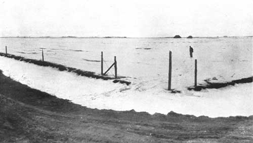
|
| FIGURE 65.—Winter view of an extremely flat, undissected area of Holdrege silt loam a few miles east and north of Holdrege, Nebr. For several miles in each direction this flat is interrupted only by about one drainage way per mile, not exceeding 8 feet in depth and not interfering with cultivation. Occasional undrained depressions occur in which the soil is more clayey and is classed as "Scott." (F298789) |
The topsoils range from 10 to 18 inches thick, have accumulated large amounts of well-decayed organic material, and are very dark (fig. 66). The subsoils are brown in the upper part and light gray in the lower. They are very limy below depths of 3 or 4 feet. The entire soil section is composed largely of silt. The Holdrege soils are friable throughout. The subsoils of the Hastings are slightly compact in the upper part but are easily penetrated by moisture, air, and roots.
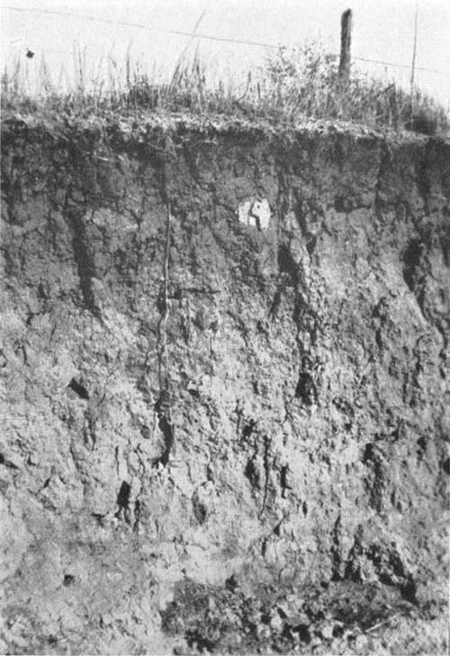
|
| FIGURE 66.—Profile of Holdrege silt loam, Gosper County, Nebr. This soil has a thick dark-colored topsoil and is friable to great depths. |
The Hastings and Holdrege soils have high moisture-holding powers but are unable to absorb as much of the precipitation as more sandy soils. Moreover, the absorbed moisture is held higher in the soil section than it is in sandy soils and is subject to greater evaporation loss. In the eastern part of the shelterbelt zone these soils receive enough rainfall to give them an adequate moisture supply except during the most prolonged droughts, but in the western part their available moisture is too low for good tree growth.
Most of the tree species and shrubs common to the uplands of central Nebraska are growing on the soils of this group, including honeylocust, American elm, green ash, mulberry, Osage-orange, hackberry, dwarf Asiatic elm, Russian-olive, lilac, wild plum, choke cherry, and red cedar. The trees are more vigorous in the eastern than in the western part of the zone, but few of them attain a height of 40 feet on any of the Holdrege or Hastings soils.
COLBY SILTY SOIL GROUP
The Colby soils as mapped in this survey occur in both the eastern and western parts of the central section. In recent surveys of Nebraska some of these soils are designated as "Keith." In the western part of their distribution, the Colby soils occur on the smooth loess-mantled plain of southwest Nebraska and northwest Kansas (fig. 37). Here they have developed in a region of light rainfall under a short-grass vegetation and in the absence of severe erosion. They resemble the Holdrege soils except that they have thinner and lighter colored topsoils and are more limy (fig. 67). In the eastern part of the shelterbelt zone, the soils mapped in this survey as Colby include areas in which Holdrege and Hastings soils have been so thinned and lightened by erosion in their surface layers that the resultant soil is essentially similar to the true Colby farther west. These areas have a strongly rolling to hilly surface but are not sufficiently broken to be classed as rough land.
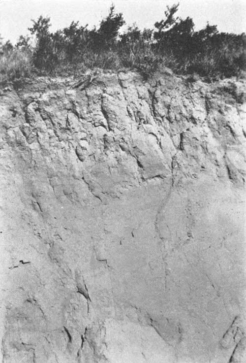
|
| FIGURE 67—Profile of Colby silt loam, Rawlins County, Kans. This soil differs from Holdrege in that it has a lighter colored topsoil. It has developed under rather arid conditions. |
The Colby soils do not differ essentially in their moisture-absorbing and holding capacities from the Holdrege and Hastings soils. They are among the most drought-resistant of the finer textured upland soils in the shelterbelt zone, but they are less resistant to drought than some of the sandier soils.
Most trees commonly grown on the uplands of central Kansas and Nebraska are making good growth on Colby soils in the eastern part of the zone. In the western part, only the most drought-resistant species are surviving. Few of the planted ash, honeylocust, or black locust growing on the western Colby soils exceed 20 feet in height, regardless of their age. There are practically no native trees growing on these soils in either the eastern or western parts of the zone. Much of the green ash and black locust on the Colby and associated soils of Nebraska and Kansas has suffered severely from borers.
CRETE AND GRUNDY CLAYPAN SOIL GROUP
Crete soils, which in some of the older county surveys were correlated as Grundy, extend into the shelterbelt zone in south-central Nebraska. These soils have developed on nearly level areas of the loessial uplands under a precipitation sufficient to support mixed tall and short grasses.
The topsoils, which extend to depths of 14 to 16 inches, are composed of friable silt intimately mixed with an abundance of black organic matter which gives them a very dark color. They overlie a brownish clay-pan 12 to 20 inches thick. The remainder of the section consists of loose, floury, and highly calcareous silt which rests on the parent loess at depths of 4 or 5 feet. The claypan has developed largely from clay carried into the subsoils by percolating waters. "Alkali" salts may have contributed to its development; none of the Crete soils, however, is now alkaline.
Although the soils of this group are underlain by claypan, they receive enough precipitation to give them a favorable moisture supply except during the most severe droughts. They do not seem to be particularly inimical to tree growth. Fairly good groves of honey-locust, American elm, mulberry, red cedar, green ash, Osage-orange, and ponderosa pine were observed on them in south-central Nebraska. It is possible that the claypan may be unfavorable to some species. No definite conclusion has as yet been drawn in this regard.
SCOTT CLAYPAN GROUP
Scattered throughout the finer textured and more nearly level upland soils in the central section are shallow basins or depressions occupied by claypan soils. They are comprised chiefly of the Scott claypan group but include correlated bodies of the Butler and Fillmore soils.
The basins, which are locally known as "buffalo wallows" or "lagoons", seldom exceed 500 acres and generally occupy less than 10 acres. There is usually one or more of them in each square mile throughout the uplands. Only the largest ones, as in Scott County, Kans., and Phelps County, Nebr., are shown on the map.
The Scott soils have thin, dark surface layers underlain by extremely dense, dark-gray claypans, ranging from about 18 inches to 4 feet or more in thickness. The Butler and Fillmore soils differ from the Scott mainly in that they have thicker topsoils and slightly thinner and darker claypans.
The claypans of the Scott, Butler, and Fillmore soils are almost impervious to water, and the basins in which they occur are occupied by shallow ponds for several weeks after rains. When the water evaporates the soils become extremely dry and shrink and crack badly. Most of the depressed areas are used for pasture land.
The soils of this group as a whole are unsuited to trees, owing largely to the wide range of moisture conditions to which they are subjected. In a few places green ash was observed growing on Butler soil, which occupies the shallower basins and has the thinner claypan.
MOODY SILTY SOIL GROUP
Moody soils are developed on the loess-mantled uplands in the northeastern part of the central section and occupy a few areas in the southern part of the northern section. They have nearly level to strongly rolling surfaces and are everywhere well drained.
These soils are somewhat similar to the loessal Holdrege soils of south-central Nebraska and northern Kansas but differ from them in having slightly thinner surface layers and more limy subsoils. Their outstanding feature, and the one which serves to distinguish them from all other loess-derived soils is a subsoil zone which is unusually rich in small lime concretions.
The Moody soils have high moisture-holding powers and are friable throughout. They are in a region where the precipitation is sufficient to give them a good moisture supply. All of them are well suited for the trees and shrubs mentioned in connection with the Holdrege group.
SOILS OF LOESS TABLES AND CANYONS
The group of loess table and canyon soils is mapped to include the soils of areas in which the smooth loess plains are dissected by erosion into a series of long, narrow, and flat-topped divides separated by steep-sided valleys or canyons (figs. 68 and 69). Few of the divides exceed 3 miles in width, and most of them are much narrower. They are occupied almost entirely by the silty Colby, Holdrege, and Hastings soils, all of which have been described. The canyons vary in width from a few rods to about a quarter of a mile. Many of them have flat floors on which the soils are rather dark, but unweathered loess is exposed on all of the slopes leading to the divides.
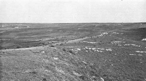
|
| FIGURE 68.—Eroded but rather gently sloping phase of Colby silt loam, Frontier County, Nebr. A wide variety of trees is suited for forest shelterbelt planting on the Colby silt-loam soils. |
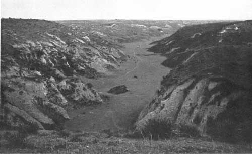
|
| FIGURE 69.—Characteristic topography of the loess tables and canyons, Frontier County, Nebr. Even this deep erosion may not go to the bottom of the loess deposit from which the Colby silt-loam soil is developed. |
None of the soils within areas belonging to this group is inimical to trees, although some of the areas lie in a region where the precipitation is too low to support any except the most drought-resistant species.
Hackberry, honeylocust, Russian-olive, dwarf Asiatic elm, American elm, mulberry, lilac, choke cherry, and red cedar have, with good care, given fair results in the western areas of this soil group. Green ash also does fairly well but is more or less subject to borer damage. Throughout their eastern distribution the soils of the loess tables and canyons are suited to all species mentioned in connection with the Holdrege and Hastings silty soil group.
DUNE-SAND GROUP
Areas belonging to the dune-sand group are mapped in the northern, central, and southern sections of the shelterbelt zone. The largest areas are in the central section, where they occupy several thousand square miles in the sand-hill regions of north-central and southwestern Nebraska.
Dune sand is not a soil. It occurs as a succession of sand hills and ridges, some of which rise 100 feet above their surroundings. Valleys, pockets, and swales are of frequent occurrence. The wetter of these are occupied by Gannett and the drier by Valentine soils, neither of which is in bodies of sufficient size to be shown on a small map.
The Forest Service has planted thousands of acres of ponderosa and jack pine in the Nebraska sand hills. Red cedar has also been planted and is increasing in favor. These species are growing well, although the pine is considerably handicapped by tip-moth injury. Some planted hardwoods, chiefly cottonwood and willow, thrive on the Gannett and Valentine soils where the water table is at shallow depths.
VALENTINE, ANSELMO, GANNETT SANDY SOIL GROUP
The soils of the Valentine, Anselmo, and Gannett group cover a large total area in the central section, where they occur as numerous bodies and strips within and around the edges of the sand hills. Most of the bodies are small. Only the larger ones are shown on the map.
The Valentine, Anselmo, and Gannett soils are composed largely of sand. The first two, which are the more extensive, occupy undulating to rolling well-drained areas. They have accumulated only small amounts of organic matter and have rather thin top-soils of brown or light-brown color. The subsoils are gray, those in the Valentine consisting almost entirely of loose sand, whereas the Anselmo subsoils contain sufficient silt to give them good body. The Gannett soils are in poorly drained pockets or basins throughout the sand hills. They have developed under conditions favorable to rapid vegetal growth and decay and have thick, almost black topsoils. Their subsoils are usually composed of loose gray sand but in local areas may contain a thin clay layer. Some of the Gannett soils are rather alkaline, especially in the western part of Nebraska.
The soils of this group, as a whole, are well suited to trees. Red cedar, ponderosa pine, mulberry, green ash, and cottonwood are surviving well on many of the farmsteads within Valentine soil areas. Scattered willow and cottonwood trees grow naturally within and around the edges of some of the Gannett soil bodies, which are generally too alkaline for pines. The Anselmo soils seem well adapted to honeylocust, American elm, boxelder, Russian-olive, choke cherry, mulberry, red cedar, and ponderosa pine.
ALLUVIAL SOILS UNDIFFERENTIATED
The alluvial soils of the central section comprise soils of the first bottom on flood plains along streams. Only the wider developments are shown on the map. These include various types of the Lamoure, Laurel, Minatare, Cass, and Sarpy soils. The first three named have developed from fine-textured stream sediments and have silty or clayey profiles. The Cass and Sarpy soils have developed over sandy or gravelly sediments. Aside from the Minatare and Sarpy, which are rather light-colored even at the surface, all soils of this group have accumulated an abundance of black humic material and have very dark topsoils. Locally the flood-plain soils may be alkaline.
The alluvial soils of the central section are well adapted to a variety of trees except in spots where alkali is sufficiently abundant to be injurious. Cottonwood, hackberry, willow, green ash, catalpa, black walnut, American elm, honeylocust, black locust, mulberry, Russian-olive, Osage-orange, red cedar, and several other trees do well on these soils. Coffeetree, sycamore, and silver maple occur in places.
ROUGH BROKEN AREAS
Rough broken land comprises several areas in the central section. They are indicated by diagonal cross-hatching on the map. Those composed of soils belonging to the same group are further indicated by the group number. Those composed of a mixture of soils belonging to several groups are indicated by the number (1).
Practically all of the rough broken land shown on the map of the central section is too rough or stony for farming. That in northwestern Nebraska includes Pine Ridge, Wildcat Range, and areas of extremely broken and stony land on the valley slopes along the Platte and Republican Rivers. In these localities erosion has exposed and deeply carved the basal Tertiary sandstone formation. Throughout the remainder of the section most of the rough broken areas are occupied by severely eroded loess, although some of them include Tertiary material.
Trees grow naturally in many of the rough broken areas. In the canyons of western Nebraska native American elm, hackberry, green ash, boxelder, cottonwood, red cedar, choke cherry, and wild plum occur in several places. In parts of Sheridan, Dawes, and Sioux Counties, Nebr., considerable areas of broken land are occupied by a natural growth of ponderosa pine. Red cedar, aspen, mountain-ash, dwarf maple, and narrowleaf cottonwood occur locally in Sioux County.
SOILS OF THE SOUTHERN SECTION
Most of the southern section of the shelterbelt zone has been covered by reconnaissance soil surveys,45 including those of western Kansas and the Panhandle section of Texas, which were made in 1910, and a similar survey45 of northwest Texas made in 1919. The Oklahoma portion of the southern section has had no reconnaissance surveys, although a detailed soil survey45 of Roger Mills County was made in 1914. Detailed soil surveys45 of a few Texas and Oklahoma counties within the southern section have been made during the past few years but as yet these are unpublished. The Oklahoma and Texas parts of the zone that had not been covered by soil surveys were mapped in a rapid reconnaissance46 and the boundaries of the general soil groups determined during the present survey.
45Bureau of Chemistry and Soils.
46This reconnaissance and the descriptions of the soil groups were prepared by W. T. Carter, inspector, southwestern district, Soil Survey Division, Bureau of Chemistry and Soils.
Each of the soil group areas shown on the map of the southern section includes a number of soils. In most of the areas the more extensive soils are similar in their broader characteristics and their adaptabilities for trees. Some of the areas are mapped entirely on the basis of their rugged surface features and may include a number of soils having widely divergent characteristics. The soil names used in this section are taken from recent correlations and in many instances differ from those used in the original surveys.
The following soil groups are recognized and shown on the map covering the southern section of the shelterbelt zone (fig. 40).
| Number on map | ||
| Richfield and Pullman fine-textured soil group | 11 | |
| Includes silty clay loam types of these Soils and small areas of Potter and Zita soils. Also includes Amarillo silty clay loam as mapped in the 1910 reconnaissance soil survey of the Panhandle section of Texas. | ||
| Richfield fine-textured soil group | 5 | |
| Includes Richfield silt loam, Greensburg silty clay loam and silt loam, Summit silt loam and silty clay loam, and small areas of Potter soils. | ||
| Zita and Potter shallow soil group | 10 | |
| Includes Zita and Potter loams and fine sandy loams and small areas of rough broken land. | ||
| Hamilton soil group | 15 | |
| Includes Hamilton silt loam and silty clay loam. | ||
| Amarillo sandy soil group | 20 | |
| Composed chiefly of Amarillo fine sandy loam. | ||
| Pratt sandy soil group | 4 | |
| Includes Pratt fine sandy loam, loamy fine sand, loamy sand, gravelly sandy loam, and coarse sandy loam, Richfield sands and sandy loams, and small bodies of Enterprise fine sand. Also includes some sandy Albion soils as mapped in Reno County, Kans. | ||
| Miles sandy soil group | 12 | |
| Includes Miles fine sand and fine sandy loam, small bodies of Abilene, Enterprise, and Vernon sandy soils, and dune sand. | ||
| Abilene sandy soil group | 13 | |
| Includes Abilene fine sands and fine sandy loams, also some bodies of Miles and Vernon sandy soils. | ||
| Vernon sandy soil group | 8 | |
| Includes Vernon, Mutual47, and Woodward47 fine and very fine sandy loams and Vernon clay loam. | ||
| Miles-Vernon sandy soil group | 3 | |
| Foard, Tiliman, Hollister, St. Paul, Abilene, and Roscoe heavy soil group | 14 | |
| Includes silt loam, clay loam, and silty clay loam types of these soils. | ||
| Alluvial soils undifferentiated | 35 | |
| Vernon soils and rough broken areas | 9 | |
| Includes areas in which rough broken land and tillable areas of Vernon soils are so intricately associated that they cannot be separately indicated on a small map. | ||
| Dune-sand group | 30 | |
| Consists Chiefly of Enterprise sand (dune phase). | ||
47Tentative correlations.
Summarized data pertaining to the above groups 5 are given in table 22.
RICHFIELD AND PULLMAN FINE-TEXTURED SOIL GROUP
The Richfield and Pullman fine-textured soil group consists almost entirely of Richfield and Pullman silty clay loam soils but includes also small areas of Potter and Zita clay loams and loams.
The Richfield silty clay loam consists of brown or dark brown silt loam overlying very dark brown moderately heavy, silty clay or clay. The material below a depth of 3 or 4 feet is highly calcareous and merges gradually downward into grayish-yellow marl, from which the soil has developed.
TABLE 22.—General characteristics of soils of the southern section of the Shelterbelt Zone (Texas and Oklahoma)
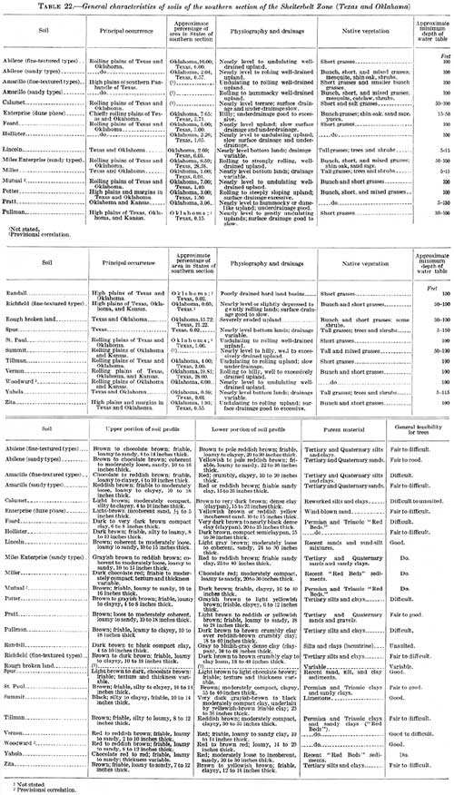
(click on image for a PDF version)
The Pullman silty clay loam differs from the corresponding texture of the Richfield soil chiefly in that it has a slightly lighter colored topsoil (fig. 70). Both soils are developed on nearly level surfaces, but the Richfield usually occupies the almost dead-level or slightly depressed situations, while the Pullman, in most places, has sufficient slope to permit water to run off slowly
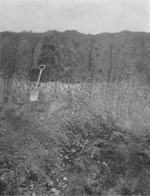
|
| FIGURE 70.—Profile of Pullman silty clay loam, showing a thick top soil and a well-developed zone of lime accumulation, Potter County, Tex. This soil is heavy but not compact. |
This soil group covers most of the smooth High Plains of the Texas Panhandle, the Richfield occurring more extensively north of Canadian River and in the eastern part of the High Plains south of that stream (fig. 71).
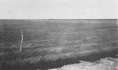
|
| FIGURE 71.—A typical stretch of Richfield silt loam, which, with the closely related Pullman soil, characterizes the surface of the slightly undulating High Plains of the western Texas Panhandle, a small portion of Oklahoma, and southwestern Kansas. This view, showing closely grazed buffalo grass sod, was taken 8 miles south of Dodge City, Kans. (F298779) |
The water table throughout most of the area lies at depths ranging from 100 to 300 feet, though in some localities of the Texas portion water can be obtained at depths of 30 to 70 feet.
Many small depressions or lake beds are within the areas mapped with this soil group. These contain water, often for several weeks, after heavy rains, but are dry most of the year. They are occupied by Randall clay, a dark-gray, dense formation several feet deep which has been thoroughly leached of its lime.
The Pullman and Richfield silty clay loams have high moisture-holding powers, and their smooth surfaces favor the collection and retention of water. They are in a region, however, where much of the precipitation falling on fine-textured soils evaporates before it can penetrate deeply and is rather ineffective in supplying the soils with sufficient moisture for good tree growth.
Few trees are making vigorous growth on the soils of this group. The species which seem to be surviving best are red cedar, desert-willow, lilac, tamarisk, Russian-olive, dwarf Asiatic elm, honeylocust, and hackberry. Few of these trees, except where artificially watered, exceed 20 feet in height, and most of them are lower. It is doubtful that extensive tree planting on the soils of this group will be successful, and the shelterbelt zone has been so delimited as to avoid them for the most part.
RICHFIELD FINE-TEXTURED SOIL GROUP
The Richfield fine-textured soil group, which consists chiefly of Richfield silt loam, comprises most of the High Plains occurring within the shelterbelt zone in southwest Kansas and northwest Oklahoma.
The group includes large areas of soils classed on the reconnaissance soil map of western Kansas as Greensburg and Summit silt loams and silty clay loams. From examination it appears that there is insufficient difference between them and true Richfield silt loam to warrant a separation for the present purpose.
The topsoil of Richfield silt loam is dark-brown, mellow silt loam about 10 inches thick. The upper subsoil is light-brown, moderately heavy clay loam which grades at a depth of about 26 inches into grayish-brown calcareous silty clay loam. The parent material is soft brownish-yellow marl. It is highly calcareous and lies within a depth of about 4 feet. The entire soil section is friable. The water table is 100 to 300 feet deep.
The surface of the Richfield silt loam ranges from nearly level to very gently rolling. All of the soil has adequate surface and underdrainage.
This group, as mapped, extends almost across the shelterbelt zone in southern Kansas and entirely across it in central Kansas. The soil has a high moisture-holding capacity but in the western part of its range is unable to absorb enough of the rather low precipitation to support good tree growth. In the eastern part of the zone it is fairly well adapted to dwarf Asiatic and American elm, hackberry, red cedar, Russian-olive, mulberry, lilac, and tamarisk, although practically none of these trees has made good height growth. Many black locust and green ash trees have been planted on this soil, but most of them have been injured by borers, especially in the western part of the zone.
ZITA AND POTTER SHALLOW SOIL GROUP
The Zita and Potter shallow soil group is composed mainly of loams and fine sandy loams. It also includes small scattered areas of rough broken land.
The Zita and Potter soils are developed on unconsolidated marl-like beds of the High Plains, under conditions of rather severe sheet erosion. They occupy gentle to fairly steep slopes within areas of the Richfield and Pullman soils and occur also on the escarpment leading down from the High Plains to the Rolling Plains on the east. Most of the areas shown on the map are in northern Texas and northwestern Oklahoma.
The Potter soils have thin top soils ranging in color from brown to grayish brown and in texture from loam to sandy loam. The subsoils are lighter in color than the topsoils. They usually consist of clay loam or loam but in many places are composed of gray chalky marl which has been little modified by weathering. Numerous outcrops of marl are characteristic.
The Zita soils differ from the Potter only in that they are a little better developed. They have slightly thicker topsoils and subsoils and occupy less steeply sloping surfaces.
The soils of this group are not well suited to trees, owing largely to unfavorable moisture conditions. Much of the precipitation is lost as run-off before it can penetrate the ground. Some of the smoother areas of the Zita soils have about the same tree adaptations as the Richfield and Pullman soils, but the more eroded areas are of little value for shelterbelt planting.
HAMILTON SOIL GROUP
The soils of the Hamilton group have no relation to the shelterbelt zone as it now exists. They occupy an upland area north of the Arkansas River in the extreme western part of Kansas. They appear to bear only scrubby tree growth and are considered unsuited to shelterbelt planting.
AMARILLO SANDY SOIL GROUP
The Amarillo sandy soil group is occupied chiefly by Amarillo fine sandy loam, which occurs on the High Plains of Texas considerably west of the extreme southern part of the shelterbelt zone. The soil lies adjacent to the heavier Pullman and Richfield soils. Should shelterbelt planting later be attempted on the High Plains of Texas, the soils of this group have better possibilities than any other of the finer textured upland soils. These possibilities are not encouraging, however, on account of the scanty rainfall of the section.
The topsoil is red or reddish-brown fine sandy loam, 10 or 15 inches deep. This grades below into friable red fine sandy clay or fine sandy loam, which becomes highly calcareous at an average depth of 3 feet. The subsoil rests on Plains marl.
PRATT SANDY SOIL GROUP
The soils of the Pratt sandy soil group occupy large areas in southern Kansas and northwestern Oklahoma and are locally developed in the northern part of the Texas Panhandle. They have developed from sandy materials, the greater part of which were probably produced through the weathering of sandy Tertiary formations—although in some areas of the Pratt soils they came from sandy shales of the "Red Beds." In most places the parent material has been so mixed and reassorted by the wind that it is impossible to make any definite statement in regard to its origin.
The Pratt soils as mapped in this survey are variable, but nearly all of them are sandy. The topsoils in most places have accumulated rather large amounts of organic matter and are brown or grayish brown. They range in texture from fine sandy loams to sands, the loamy sands predominating. The subsoils are composed largely of loose sand but may locally contain considerable amounts of clay. They are light brown or reddish brown. Some of them are calcareous.
The surface features of the Pratt soils have been produced largely by wind, which has whipped the loose sands into low rounded hummocks and ridges, creating a gently rolling or billowy topography. Locally, the surface, especially that of the coarser textured types, is somewhat dunelike.
The soils of this group absorb practically all of the precipitation and, considering their sandy character, have high moisture-holding powers. Those in southwestern Kansas do not receive enough moisture to insure satisfactory growth of any except the most drought-resistant trees and shrubs. Those in the shelterbelt zone, however, not only offer good chances of growth and survival to drought-resistant species but also are fairly favorable to such trees as boxelder, cottonwood, ponderosa and Austrian pine, wild cherry, tamarisk, silver maple, black walnut, coffee-tree, sycamore, and catalpa. The last four species mentioned seem much better adapted to the finer- than to the coarser-textured soils of the group.
MILES-ENTERPRISE SANDY SOIL GROUP
The Miles sandy soil group includes soils characterized by grayish-brown loose sand or fine sandy loam topsoils and friable red sand-clay subsoils. The top soils range from a few inches to about a foot in thickness. The subsoils are usually calcareous.
These soils have developed from water-laid sandy clays which thinly cap the "Red Beds" in places and which are probably of Tertiary or Quaternary age. They have undulating to hilly surfaces. Their top soils, being composed largely of loose sand, rapidly absorb the precipitation, and the sandy clay subsoils permit little or no moisture to be lost in the under drainage. Included with this group are some areas of Enterprise soils. These differ from the Miles chiefly in that their subsoils contain less clay, are less coherent, and have a lower lime content.
The soils of this group are very drought-resistant. All of them are well suited to trees. Much of the land occupied by them now supports thick growths of low shin oak. Hackberry, American and dwarf Asiatic elms, honeylocust, catalpa, soapberry, red cedar, mulberry, Osage-orange, lilac and desert-willow are all showing favorable growth. The following species are less extensively grown but seem to give fair results: Black locust, silver maple, coffeetree, sycamore, apricot, gum elastic, black walnut, little walnut, Austrian pine, Arizona cypress, Russian-olive, ponderosa pine, wild plum, wild cherry, and redbud.
ABILENE SANDY SOIL GROUP
The Abilene sandy soil group as mapped consists chiefly of sandy types of the Abilene soils, which occupy only a small area in the shelterbelt zone. Most of these soils are in Roger Mills County, Okla., where they were correlated as Richfield soils in an earlier survey. They have developed from Tertiary or Quaternary deposits which locally cover the "Red Beds."
The Abilene soils are characterized by grayish-brown sandy or loamy topsoils and yellowish-brown sandy clay subsoils. They resemble the Miles soils in topographic, drainage, and textural features but differ from them in subsoil color.
The soils of this group have rapid water-absorbing and high moisture-holding capacities. They are very drought-resistant and are well adapted to a variety of trees, including most of the species mentioned in connection with the soils of the Miles sandy soil group. Much of the area occupied by the Abilene soils is now covered by a rather thick growth of shinoak.
VERNON SANDY SOIL GROUP
The Vernon sandy soil group comprises a number of red and reddish-brown soils, largely of sandy texture, on the rolling "Red Bed" plains of western Oklahoma and the eastern part of the Texas Panhandle. These soils have developed from reddish-colored sandy shales or sandy clays. The group as provisionally correlated includes three principal soils, namely, Vernon, Woodward, and Mutual.
The Vernon soils are composed largely of fine or very fine sandy loam but locally contain considerable clay. They have no well-developed topsoil and subsoil layers. The sandy shales or sandy clays of the "Red Beds" from which they are forming are, in many places, within a depth of 2 or 3 feet. The Vernon soils are calcareous even at the surface, and have a bright-red or reddish-brown color. The topography, as a whole, ranges from gently rolling to hilly. These soils are very erosive and include numerous small areas in which the "Red Beds" have been deeply carved.
The Woodward soils are similar to Vernon but occupy smoother areas, have slightly thicker and darker topsoils, and are a little more deeply developed. Their subsoils are red and very limy.
The Mutual soils are on the more nearly level-lying areas of the rolling "Red Bed" plains and have well-developed profiles. Their topsoils are brown and are underlain by thick, friable clay loam or loam subsoils of reddish-brown color. Lime occurs at a depth of several feet.
The soils of this group are well enough watered in the shelterbelt area to support a variety of tree growth. Native growths of shin oak and mesquite occur on them in places. On the more level-lying areas, the following species have been planted and are growing with reasonable vigor: Honeylocust, Osage orange, green ash, hackberry, dwarf Asiatic elm, soapberry, Russian-olive, desert-willow, redbud, red cedar, Arizona cypress, apricot, and wild plum.
MILES-VERNON SANDY SOIL GROUP
The Miles-Vernon sandy soil group occupies areas in which sandy Miles and Vernon soils are so intimately mixed that separations are impracticable on a small map. Within these areas the parent soils materials consist of patchy remnants of Tertiary and Quaternary sandy clays which cap the "Red Bed" formations in numerous places. Practically all of the areas are in the north Texas portion of the shelter-belt zone. The individual soils are similar to those in other groups with which they are associated (figs. 72 and 73).
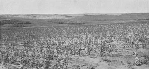
|
| FIGURE 72.—Miles loamy sand (cotton field in foreground) showing the shin oak cover which prevails more or less on this soil in western Oklahoma and the eastern portion of the Texas Panhandle. Location 7 miles north of Ramsdell, Wheeler County, Tex. |
|
| FIGURE 73.—View of the fine sandy phase of Vernon soil of the Rolling Plains of western Oklahoma in Harper County. The less droughty character of these soils, as compared with the Richfield of the High Plains (fig. 71) may be noted here. |
FOARD, TILLMAN, HOLLISTER, ST. PAUL, ABILENE, AND ROSCOE HEAVY SOIL GROUP
The group of Foard, Tillman, Hollister, St. Paul, Abilene, and Roscoe heavy soils cover a large area in southwestern Oklahoma and occur locally in the northwestern part of that State. They are found in nearly level to rolling situations on the "Red Bed" plains. The soils have moderately heavy silt loam or clay loam surface layers underlain in most places by heavy clay subsoils which vary in their physical features. All soils of this group have developed mainly from "Red Bed" materials and have highly calcareous subsoils.
The Foard soils have nearly level surfaces. They have light-brown to dark-brown silty clay loam topsoils underlain by brown dense claypan upper subsoils.
The Tillman soils are on undulating surfaces. They have brown topsoils and reddish-brown, heavy but not claypan subsoils.
Hollister soils are dark brown in the upper layers and have dark-colored semiclaypan subsoils, ranking between the Foard and Tillman in claypan tendencies.
St. Paul soils have uniformly rich-brown surface layers overlying brown, thick subsoils which are only moderately compact.
The Abilene soils belonging to this group are much heavier than those of the Abilene sandy group. Here they differ from the St. Paul soils chiefly in origin; the Abilene is developed on materials from Tertiary or Quaternary deposits, whereas the St. Paul are formed largely on older formations.
Roscoe soils have black or very dark-brown topsoils overlying moderately compact dark-gray or brown subsoils. They differ from the Foard soils chiefly in that their subsoils are less compact.
Although the soils of this group have high clay content and slow moisture-absorbing powers, they lie in a region where the precipitation is sufficiently abundant to offset the latter disadvantage in large degree, especially on the less clayey members. Time did not permit a study of the trees on these soils.
ROUGH BROKEN AREAS
Rough broken land is extensive in the southern section and is indicated on the map in the same manner as in the northern and central sections. It comprises areas of steeply sloping lands or breaks which are so severely eroded that they are of no value for farming except in local patches. Large developments occur on the escarpments bordering the High Plains areas in Texas, where erosion has cut through thick Tertiary deposits and has greatly dissected the underlying "Red Beds." Large developments also occur on the rolling "Red Bed" plains in western Oklahoma.
Considerable areas of these breaks can be advantageously planted to conserve run-off and prevent erosion. Red cedars grow naturally in many places.
ALLUVIAL SOILS UNDIFFERENTIATED
The soils of the first bottoms or flood plains occupy narrow strips in the southern section. Only the wider developments are indicated on the map, and the width of these is perhaps exaggerated in many places.
The widest strips of alluvium are along the Arkansas River, where they are occupied chiefly by the friable, fine-textured Laurel soils. The sandy brown soils of the narrow bottom lands in the rolling "Red Bed" plains are classed as Lincoln soils. Some of these soils along the Cimarron River and the north fork of Canadian River contain alkali. Red alluvial soils occur in narrow strips along streams passing through "Red Bed" formations on the Rolling Plains. Those composed largely of silts and clays are classed as Miller, while those of a sandy character are correlated as Yahola soils. Narrow strips of Spur soils, having chocolate-brown topsoils and slightly lighter colored subsoils, occur along some of the drainage ways in the High Plains. The Spur soils vary little in texture from the surface downward.
Practically all the soils in the bottom lands of the southern section are well adapted to trees. Most of them are underlain by a water table within the reach of tree roots. Cottonwood, hackberry, and American elm grow naturally and attain considerable size on these soils. Native willows, soapberry, gum elastic walnut, mulberry, and wild plum also occur. Among the planted trees and shrubs, dwarf Asiatic elm, honeylocust, catalpa, black locust, coffeetree, ailanthus, apricot, red cedar, Russian-olive, lilac, desert-willow, and redbud are well adapted to most of these soils.
VERNON SOILS AND BOUGH BROKEN AREAS
The group of Vernon soils and rough broken areas includes areas in which the Vernon and Potter soils and rough broken land occur in such small and intricately associated bodies that separations are not practical in a reconnaissance survey
The Vernon soils, chiefly Vernon fine sandy loam, cover the greater part of the area included in the group. They are found on rolling to hilly land and are associated with Potter fine sandy loam, especially in localities where the "Red Beds" are capped by thin Tertiary remnants. Narrow strips and small, irregular-shaped bodies of rough broken land occur where erosion has deeply carved the Tertiary and "Red Bed" deposits.
The species listed as giving the best results on the soils of the Miles group are equally well adapted to the sandier Vernon soils of this group. Planting of drought-resistant trees can be done advantageously even on the Potter soils and rough broken land, especially as a water-conservation and erosion-control measure.
DUNE-SAND GROUP
Dune sand in the southern section is usually browner than that in the northern and central sections and generally has a reddish tinge not present in the more northern dune sand. It is classed in detailed soil surveys as Enterprise fine sand, dune phase. Aside from color, the material is almost identical with that of the Nebraska sand hills. The surface features are similar to those in the more northern sand-hill areas.
Dune sand covers several rather large areas in the southern section. Most of it is on the rolling "Red Bed" plains near the Red River-Panhandle angle of Texas and Oklahoma. Although very dunelike, it is protected from blowing in most places by a sparse cover of grasses. Practically all of it is included in grazing land. No shelterbelt planting is contemplated on this material, although in places extensive forest planting would be a possibility.
ACKNOWLEDGMENTS
The maps and data for the report covering this investigation were compiled jointly by the writers and by W. T. Carter, J. E. Lapham, and W. I. Watkins, of the Bureau of Chemistry and Soils. P. J. Watterberg, O. J. Grace, F. E. Wilder, and W. D. Griggs assisted in the field work.
The writers are indebted to G. E. Condra, director of the conservation and Survey division of the University of Nebraska, for providing the Survey headquarters with office, drafting, and library accommodations, and for making available the assistance of L. A. Brown, E. H. Tyner, and B. J. Abashkin in the preparation of data.
As noted in the report, H. H. Bennett, of the Soil Conservation Service, supplied erosion maps of the shelterbelt area. Various soil and geologic data were furnished by H. L. Walster, J. G. Hutton, R. I. Throckmorton, and N. E. Winters.
BIBLIOGRAPHY
The following references, among others, were consulted in preparing the descriptions and maps included in the preceding report:
BODE, I. T.
1920. THE RELATION OF SMALLER FOREST AREAS IN NON-FORESTED
REGIONS TO EVAPORATION AND MOVEMENT OF SOIL MOISTURE. Iowa Acad. Sci.,
Proc. 27: 137-157, illus.
BOWMAN, ISAIAH
1911. FOREST PHYSIOGRAPHY: PHYSIOGRAPHY OF THE U. S. AND PRINCIPLES OF
SOILS IN RELATION TO FORESTRY. 759 pp., illus. New York, John Wiley
& Sons, Inc.
BROWN, I. C., RICE, T. D., AND BYERS, H. G.
1933. A STUDY OF CLAYPAN SOILS. U. S. Dept. Agr. Tech. Bull. 399, 43
pp.
CARTER, W. T.
1931. THE SOILS OF TEXAS. Tex. Agr. Expt. Sta. Bull. 431,
192 pp., illus.
CONDRA, G. E.
1920. THE SOIL RESOURCES OF NEBRASKA. Nebr. Univ. Conserv. and Soil
Survey Bull. 15, 76 pp., illus.
______
1934. GEOGRAPHY, AGRICULTURE, INDUSTRIES OF NEBRASKA.
307 pp., illus. Lincoln, Nebr., University Publishing Co.
DARTON, N. H.
1909. GEOLOGY AND UNDERGROUND WATERS OF SOUTH DAKOTA.
U. S. Geol. Survey Water-Supply Paper 227, 156 pp., illus.
DAVIS, R. O. E., AND BENNETT, H. H.
1927. THE GROUPING OF SOILS ON THE BASIS OF MECHANICAL
ANALYSIS. U. S. Dept. Agr. Circ. 419, 15 pp., illus.
GAUGER, A. W., LEONARD, A. G., CHANDLER,
E. F., SIMPSON, H. E., AND BUDGE, W. E.
1930. GEOLOGY AND NATURAL RESOURCES OF NORTH DAKOTA.
N. Dak. Univ. Bull. 11, 64 pp., illus.
GOULD, C. N.
1905. GEOLOGY AND WATER RESOURCES OF OKLAHOMA. U. S.
Geol. Survey Water Supply and Irrig. Paper 148.
178 pp., illus.
______
1906. THE GEOLOGY AND WATER RESOURCES OF THE
EASTERN PORTION OF THE PANHANDLE OF TEXAS. U. S. Geol. Survey
Water Supply and Irrig. Paper 154, 64 pp., illus.
______
1907. THE GEOLOGY AND WATER RESOURCES OF THE
WESTERN PORTIONS OF THE PANHANDLE OF TEXAS. U. S. Geol.
Survey Water Supply and Irrig. Paper 191, 70 pp., illus.
HAYES, F. A.
1928. REVISION OF THE GRUNDY SERIES OF NEBRASKA. Amer.
Soil Survey Assoc. Rept. 8, Bull. 9: 86A-99.
JOHNSON, W. D.
1900. THE HIGH PLAINS AND THEIR UTILIZATION. U. S. Geol.
Survey Ann. Rept. 21, pt. 4, pp. 601-741, illus.
KELLOGG, C. E.
1930. PRELIMINARY STUDY OF THE PROFILES OF THE PRINCIPAL SOIL TYPES OF
WISCONSIN. Wis. Geol. and Nat. Hist. Survey Bull. 77A, 112 pp.,
illus.
______
1934. MORPHOLOGY AND GENESIS OF THE SOLONETZ SOILS OF WESTERN NORTH DAKOTA.
Soil Sci. 38: 483-501, illus.
______
1935. SOIL BLOWING AND DUST STORMS. U. S. Dept. Agr.
Misc. Pub. 221, 11 pp., illus.
KINCER, J. B.
1922. ATLAS OF AMERICAN AGRICULTURE. PART II, CLIMATE; SEC. A,
PRECIPITATION AND HUMIDITY. 48 pp., illus. Washington, D. C.
______
1923. CLIMATE OF THE GREAT PLAINS AS A FACTOR
IN THEIR UTILIZATION. Amer. Geographers' Assoc. Ann. 13:
67-80, illus.
MARBUT, C. F.
1923. SOILS OF THE GREAT PLAINS. Amer. Geographers' Assoc. Ann. 13:
41-66, illus.
RUSSELL, J. C., and BURR, W. W.
1925. STUDIES ON THE MOISTURE EQUIVALENT OF SOILS. Soil Sci. 19:
251-266, illus.
SHANTZ, H. L.
1923. THE NATURAL VEGETATION OF THE GREAT PLAINS REGION.
Amer. Geographers' Assoc. Ann. 13: 81-107, illus.
______ and ZON, RAPHAEL
1924. ATLAS OF AMERICAN AGRICULTURE. PART I, SEC. E,
NATURAL VEGETATION. U. S. Dept. Agr. Bur. Agr. Econ.,
29 pp., illus.
SMITH, S. D.
1914. FORESTATION A SUCCESS IN THE SAND HILLS OF
NEBRASKA. Soc. Amer. Foresters Proc. 9: 388-395, illus.
STEVENS, J. C.
1909. SURFACE WATER SUPPLY OF NEBRASKA. U. S. Geol.
Survey Water-Supply Paper 230, 251 pp., illus.
THROCKMORTON, R. I.
1933. KANSAS SOILS AND SOIL MAP. Kans. State Bd. Agr.
Bien. Rept. 28: 91-102, illus.
TODD, J. E.
1896. THE MORAINES OF THE MISSOURI COTEAU AND THEIR
ATTENDANT DEPOSITS. U. S. Geol. Survey Bull. 144, 71 pp., illus.
______
1899. THE MORAINES OF SOUTHEASTERN SOUTH DAKOTA
AND THEIR ATTENDANT DEPOSITS. U. S. Geol. Survey Bull.
158, 171 pp., illus.
______
1900. GEOLOGY AND WATER RESOURCES OF A PORTION OF
SOUTHEASTERN SOUTH DAKOTA. U. S. Geol. Survey Water Supply and Irrig.
Paper 34, 34 pp., illus.
______ and HALL, C. M.
1904. GEOLOGY AND WATER, RESOURCES OF PART OF THE
LOWER JAMES RIVER VALLEY, SOUTH DAKOTA. U. S. Geol. Survey Water Supply
Paper 90, 47 pp., illus.
The following detailed county surveys and reconnaissance soil surveys of the and Soils, United States Department of Agriculture, were consulted in whole or in part:
North Dakota—Bottineau, McHenry, Lamoure, and Dickey Counties, Cando area, Jamestown area; reconnaissance soil survey of western North Dakota.
South Dakota.—Walworth, Hyde, Douglas, Beadle, and Brown Counties; reconnaissance soil survey of western South Dakota.
Nebraska—Sioux, Dawes, Sheridan, Box Butte, Scotts Bluff, Banner, Morrill, Garden, Kimball, Cheyenne, Deuel, Keith, Perkins, Lincoln, Chase, Dundy, Hitchcock, Red Willow, Furnas, Harlan, Franklin, Webster, Adams, Kearney, Phelps, Dawson, Buffalo, Hall, Howard, Custer, Nance, Boone, Madison, Pierce, and Antelope Counties; Frontier County (field Work in progress); surveys, completed but not published, of Hayes, Gosper, Sherman, Valley, Greeley, Wheeler, Garfield, Loup, Holt, Rock, Brown, Keyapaha, Boyd, and Knox Counties.
Kanses—Reno County; reconnaissance soil survey of southwestern Kansas.
Oklahoma—Roger Mills, Texas, Kiowa, Tillman, Greer, and Woodward Counties; Washita County (field work in progress).
Texas—Potter, Dickens, and Lubbock Counties; Randall and Wheeler Counties (not yet published); reconnaissance soil surveys of Panhandle region of Texas and of northwest Texas.
Other maps consulted were the following:
Land classification map of the central Great Plains, 1931, cooperation Department of the Interior with Department of Agriculture.
Reconnaissance soil erosion survey maps, Soil Conservation Service, Department of Agriculture (transferred from the Department of Interior, April 1935), covering the shelter-belt zone through North Dakota, South Dakota, Colorado, Nebraska, Kansas, Oklahoma, and Texas (not published).
Nebraska land classification surveys, Nebraska Conservation and Survey Division, Lincoln (not published).
| <<< Previous | <<< Contents>>> | Next >>> |
|
shelterbelt/sec12.htm Last Updated: 08-Jul-2011 |