|
Blue Ridge Parkway North Carolina-Virginia |
|
 NPS photo | |
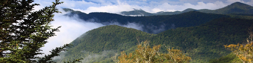
The Blue Ridge Parkway extends 469 miles along the crests of the southern Appalachians and links two eastern national parks—Shenandoah and Great Smoky Mountains.
Parkway Information
How To Use Your Brochure Major points of interest along the parkway are listed by milepost from the northern end in Virginia to the southern end in North Carolina.
Trees are everywhere. In spring, the tulip trees and serviceberry produce showy blooms. In fall, leaves burst into color. Dogwood, sourwood, and blackgum turn deep red. Tulip trees and birches turn yellow, sassafras a vivid orange, and red maples add a multicolored brilliance. Berries of the mountain ash turn bright red and are food for wintering birds. Oaks put on a dash of russet and maroon. Evergreens include the Virginia pine, white pine, hemlock, spruce, and fir.
Flowering shrubs put on a springtime show that rivals the trees' fall display. Because of the range of elevation, from 649 to 6,047 feet, blooming peaks at different times and places—somewhat earlier in Virginia than in North Carolina. Flame azalea is at its best south of Roanoke to Rocky Knob about mid-May and in the high mountains west of Asheville in mid-June. Mountain laurel blooms along Otter Creek in mid-May and elsewhere on the parkway in the first half of June. Dense thickets of catawba rhododendron turn purple north of Peaks of Otter to Onion Mountain and along the bluffs of Doughton Park the first week of June and in Craggy Gardens and through the Balsams after mid-June. Many wildflowers begin to bloom in April and continue through fall.
The southern Appalachian Mountains' diverse history and culture are described at many overlooks and facilities along the parkway, including Humpback Rocks, Peaks of Otter, Mabry Mill, Blue Ridge Music Center, Brinegar Cabin, Northwest Trading Post, and the Parkway Craft Center at Moses H. Cone Memorial Park.
In the Asheville area, stop at the Folk Art Center for craft demonstrations and at the Destination Center for general parkway information and planning your trip.
The parkway follows the Appalachian Mountain chain for seemingly endless views of parallel ranges connected by cross ranges and scattered hills. From Shenandoah National Park the parkway follows the Blue Ridge, eastern rampart of the Appalachians, for 355 miles. For the remaining 114 miles it first skirts the southern end of the massive Black Mountains, named for the dark green spruce and fir that cover them. Then it weaves through the Craggies, the Pisgahs, the Balsams to end up in the Great Smokies.
Wildlife is a delight along the parkway. When the Sun is high groundhogs sit erect, and chipmunks and squirrels chitter and chatter. At night skunks, foxes, opossums, and raccoons are seen along roadsides. Look for white-tailed deer, turkeys, and black bears in early morning or evening. Salamanders—less conspicuous but often more colorful—thrive in this moisture-rich environment. Over 100 bird species may be seen during the spring migration.
Parkway Highlights in Virginia
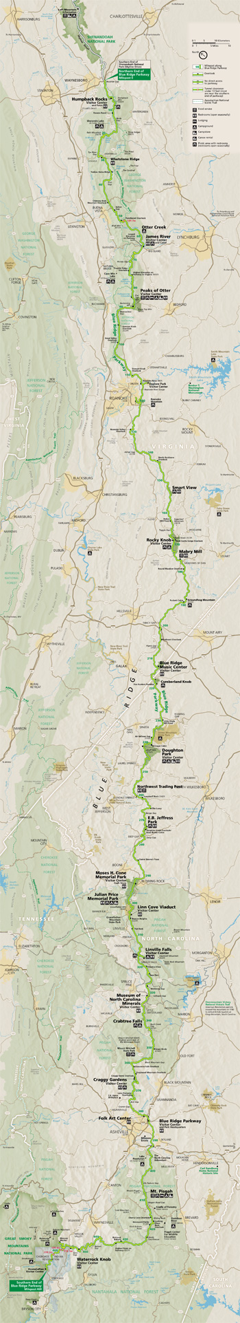 (click for larger map) |
Mile 0 Rockfish Gap near Waynesboro, Va., is the northern end of the Blue Ridge Parkway. To the north the parkway connects directly to Skyline Drive, which winds 105 miles north through Shenandoah National Park. U.S. 250 and I-64 take you to Charlottesville to the east or Staunton to the west.
5 to 9.3 Humpback Rocks has a self-guiding trail through a collection of old Appalachian farm buildings. A hiking trail from the parking area (at mile 6.1) leads 0.75 mile to The Rocks, whose humped appearance gives the area its name. Greenstone self-guiding trail (8.8).
10.7 Ravens Roost offers vistas of Torry Mountain and Shenandoah Valley to the west.
16 Sherando Lake is a recreation area in George Washington National Forest 4.5 miles from the parkway via Va. 814. Swimming, picnicking, and camping. Fees charged.
29 Whetstone Ridge gave many a mountain man a fine-grained sharpening stone.
34.4 Yankee Horse Ridge is where a hard-riding Union soldier's horse fell and supposedly had to be shot. Walk to Wigwam Falls to see a reconstructed spur of an old logging railroad.
58 to 63.6 Otter Creek tumbles 10 miles down the Blue Ridge to the James River. Otter Lake (63.1), fishing, trail.
63.8 James River and the Kanawha Canal is where a footbridge leads across the river to the restored canal locks and exhibits. A self-guiding trail follows the river bluff.
71 Petites Gap is named for a local family. The road to the west goes to Cave Mountain Lake, seven miles away, in Jefferson National Forest. Swimming, picnicking, camping.
83.4 Fallingwater Cascades can be seen along a 1.6-mile loop trail.
84 to 87 Peaks of Otter's spectacular views have been popular since the days of Thomas Jefferson. A shuttle bus provides service to Sharp Top. Fee charged.
114.9 Roanoke River Gorge opens before you from the overlook, after a 10-minute walk.
115.1 Virginia's Explore Park celebrates the state's role in Westward Expansion. Historic buildings, exhibits, and demonstrations. Fee charged.
120.4 Roanoke Mountain is a 3.7-mile side trip. The one-way loop road takes you over the mountain for impressive views. Steep grades; towed vehicles prohibited.
129.6 Roanoke Valley Overlook gives a view of the largest community along the parkway. Reach the city via U.S. 220 (at milepost 121), Va. 24 (at 112), and U.S. 460 (at 105).
154.5 Smart View is just that; go to the Trail Cabin built in the 1890s and you'll see "a right smart view," especially in early May when the dogwood trees bloom.
167 to 174 Rocky Knob rises like the cresting of a wave to overlook Rock Castle Gorge.
176.1 Mabry Mill was run by E.B. Mabry from 1910 to 1935. A trail leads you to his gristmill, sawmill, and blacksmith shop and to other exhibits. Old-time skills are demonstrated in the summer and fall.
188.8 Groundhog Mountain is a good place to see different kinds of rural fences: snake, post and rail, picket, and buck. Picnic grounds and observation tower.
213 Blue Ridge Music Center celebrates Blue Ridge music and musicians, a significant strand of American musical culture alive and thriving in the region. Includes a visitor center, museum, outdoor amphitheater, and trails. For program listings visit www.blueridgemusiccenter.org.
The Blue Ridge Parkway crosses the North Carolina-Virginia state line at mile 216.9. The 1749 party that surveyed the boundary included Peter Jefferson, father of Thomas.
Parkway Highlights in North Carolina
Mile 217.5 Cumberland Knob, at 2,885 feet, is a delightful spot to walk through fields and woodlands.
218.6 Fox Hunters Paradise, a 10-minute walk, is where hunters could listen to their hounds baying in the valley below.
238.5 Brinegar Cabin was built by Martin Brinegar about 1880 and lived in until the 1930s when the homestead was purchased from his widow for the parkway. The original cabin stands here today.
238.5 to 244.7 Doughton Park was named for Congressman Robert L. Doughton, a staunch supporter and neighbor of the parkway. One of the best places to see deer. Campground.
258.6 Northwest Trading Post offers crafts from North Carolina's northwestern counties.
260.6 Jumpinoff Rock, at the end of a short woodland trail, offers a beautiful vista.
264.4 The Lump provides sweeping views of the forested foothills.
272 E.B. Jeffress Park has a self-guiding trail to the Cascades. Another trail goes to the old cabin and church.
285.1 Daniel Boone's Trace, which Boone blazed to the West, crosses near here.
292 to 295 Moses H. Cone Memorial Park has hiking and horse trails. Flat Top Manor houses the Parkway Craft Center. Fishing.
295.1 to 298 Julian Price Memorial Park, an insurance executive's former retreat, offers a variety of short trails and a lake.
304.4 Linn Cove Viaduct, a design and engineering marvel, skirts the side of Grandfather Mountain. Visitor center and trails.
308.3 Flat Rock is well worth the walk for the superb view of Grandfather Mountain and Linville Valley.
316.3 Linville Falls roars through a dramatic, rugged gorge. Trails to overlooks.
320.7 Chestoa View trail provides outstanding scenery.
331 Museum of North Carolina Minerals interprets the state's mineral wealth with interactive exhibits.
339.5 Crabtree Meadows Walk to Crabtree Falls. Campground.
355.4 Mount Mitchell State Park, reached via N.C. 128, has a picnic area, lookout tower, and the highest point east of the Mississippi River.
363.4 to 369.6 Craggy Gardens seem to be covered with purple rhododendrons in mid- to late June. Craggy Pinnacle Trail and other trails (364.1 and 364.6); road to picnic area and trails (367.6).
382 The Folk Art Center offers sales and exhibits of traditional and contemporary crafts of the Appalachian region. Interpretive programs, gallery, and library.
384 Destination Center offers a film, exhibits, and overview of the Blue Ridge National Heritage area and the parkway.
408.6 Mount Pisgah was part of the Biltmore Estate. The estate became the home of the first forestry school in America as well as the nucleus of the Pisgah National Forest.
422.4 Devils Courthouse is a rugged, exposed mountaintop rich in Cherokee traditions. A walk to its bare rock summit rewards you with a spectacular view of Pisgah National Forest.
431 Richland Balsam self-guiding trail takes you through a remnant spruce-fir forest. The highest point on the parkway, 6,047 feet. Indigo bunting
451.2 Waterrock Knob affords a panorama of the Great Smokies. Visitor center, trail, comfort station, exhibits.
458.2 Heintooga Overlook spur road takes you to a mile-high overlook 1.3 miles from the parkway.
Mile 469 Southern End of the Blue Ridge Parkway intersects U.S. 441 in the Great Smoky Mountains National Park and the Cherokee Reservation.
Visiting the Park
Most services are available late May through October. Winter snow or ice may close sections of the parkway.
Lodging Concessionaire service is provided spring to fall along the parkway and year-round at Peaks of Otter Lodge. Reservations are recommended. Nearby communities offer lodging and other travel services.
For lodging and reservations information contact: Peaks of Otter Lodge, Rocky Knob Cabins, Bluffs Lodge, or Pisgah Inn.
Walks and Talks Be sure to take advantage of the campfire programs and conducted walks at points of interest. Activities are listed on Visitor Activities bulletin boards and in The Parkway Milepost, free at visitor centers.
Camping The nine campgrounds are open mid-May through October or early November, as weather allows. Facilities are limited in winter. Fees are charged, and lengths of stay may be limited. Camping is permitted only in designated campgrounds. There are drinking water and restrooms but no shower or laundry facilities. Campgrounds have trailer sites and sanitary dumping stations but no utility connections. Each campsite has a table and fireplace. You can buy limited supplies at most parkway camp stores. For campground reservations visit www.recreation.gov.
Trails Trails start at many overlooks. Some take 10 minutes roundtrip, others 30 minutes or more. Miles of trails explore the Peaks of Otter, Rocky Knob, Doughton Park, and Cone and Price memorial parks. The Appalachian Trail roughly parallels the parkway from mile 0 at Rockfish Gap to mile 103. Trail maps are available at visitor centers.
Picnic Areas Picnic grounds have tables, fireplaces, drinking water, and comfort stations. Many parking overlooks have picnic tables.
Regulations and Safety Tips
ENJOY THE VIEW.
WATCH THE ROAD.
Drive carefully. The maximum speed limit is 45 miles per hour. Mountain terrain and sightseeing may require slower speeds. Allow 30 miles per hour to figure actual travel time. Report accidents to a park ranger. • Commercial vehicles are prohibited. • Fasten seat belts. • Parking on shoulders is permitted only if safe and where doing so won't damage the turf or plants.
• Fires, including charcoal, are permitted only in campgrounds and picnic areas. • All plants and animals on the parkway are protected. Please watch for animals as you drive. You may gather edible fruits, nuts, and berries for your personal consumption only. Hunting is prohibited. • Pets must be kept on a leash or under physical control. • Do not litter; use trash containers and recycling bins at parking and picnic areas. • Do not swim in parkway lakes and ponds. Swimming areas are available in nearby U.S. Forest Service recreation areas, state parks, and resorts. • Only boats without motors or sails are permitted on Price Lake.
Source: NPS Brochure (2008)
|
Establishment
Blue Ridge Parkway — September 11, 1987 (construction completed) |
For More Information Please Visit The  OFFICIAL NPS WEBSITE |
Documents
2022 Socioeconomic Research of Natchez Trace Parkway: Report on 2022 Data Collection NPS Natural Resource Report NPS/NATR//NRR-2023/2579 (Otak Inc., RRC Associates and University of Montana, October 2023)
A Cultural Landscape Report: Mt. Pisgah, Blue Ridge Parkway (Suzanne Turner Associates, 2017)
A Long Road: How Jim Crow Affected the Design and Development of Recreational Areas Along the Blue Ridge Parkway (©Stephanie Heher, Master's Thesis Savannah College of Art and Design, May 2018)
A Socioeconomic Atlas for Blue Ridge Parkway and its Region (Jean E. McKendry, Adam J. Novak and Gary E. Machlis, 2003)
Blue Ridge Parkway Scenic Experience Project Final Report (Susan B. Kask, Leah Greden Mathews, Steve Stewart and Laura Rotegard, August 26, 2002)
Blue Ridge Parkway Scenic Experience Project Phase 2 Final Report (Leah Greden Mathews, Steve Stewart and Susan B. Kask, December 2003)
Blue Ridge Parkway Scenic Experience Project Results Synthesis: Phase I Southwest Virginia and Phase II Northern North Carolina (Kate Fuller, April 2004)
Cultural Landscape Report: Crabtree Falls Recreation Area, Blue Ridge Parkway (Sand County Studios, February 2017)
Cultural Landscape Report: Doughton Park and Sections 2A, B and C, Blue Ridge Parkway (The Jaeger Company, 2006)
Cultural Landscape Report for Guardrails, Blue Ridge Parkway (The Jaeger Company, November 2003)
Cultural Landscape Report: Moses H. Cone Memorial Park, Blue Ridge Parkway (Ian J. Firth, Karen G. Rehm, ed., August 1993)
Cultural Landscapes Inventory: Bluffs Coffee Shop and Service Station, Blue Ridge Parkway (Updated 12/13/2022)
Cultural Landscapes Inventory: Bluffs Lodge, Blue Ridge Parkway - Highlands District (2001)
Cultural Landscapes Inventory: Bluffs Lodge, Blue Ridge Parkway (Draft 12/13/2022)
Cultural Landscapes Inventory: Bluffs Picnic Area, Blue Ridge Parkway - Highlands District (2001)
Cultural Landscapes Inventory: Bluffs Picnic Area, Blue Ridge Parkway (Updated 12/13/2022)
Cultural Landscapes Inventory: Brinegar Cabin, Blue Ridge Parkway (Updated 12/13/2022)
Cultural Landscapes Inventory: Doughton Park, Blue Ridge Parkway-Highlands District (Updated 12/14/2022)
Cultural Landscapes Inventory: Doughton Park, Blue Ridge Parkway-Highlands District (1998)
Cultural Landscapes Inventory: Doughton Park Campground, Blue Ridge Parkway - Highlands District (2001)
Cultural Landscapes Inventory: Doughton Park Campground, Blue Ridge Parkway - Highlands District (Updated 12/14/2022)
Cultural Landscapes Inventory: Doughton Park Maintenance Area, Blue Ridge Parkway - Highlands District (Updated 12/14/2022)
Cultural Landscapes Inventory: Moses H. Cone Memorial Park, Blue Ridge Parkway (March 2014)
Cultural Landscapes Inventory: Moses H. Cone Memorial Park, Blue Ridge Parkway (Updated 12/13/2022)
Developed Area Management Plan/Environmental Assessment, Moses H. Cone Memorial Park (January 2015)
Directory & Travel Planner (©Blue Ridge Parkway Association): 2010 (61st ed.) • 2011 (62nd ed.) • 2012 (63rd ed.) • 2013 (64th ed.) • 2014 (65th ed.) • 2015 (66th ed.) • 2016 (67th ed.) • 2017 (68th ed.) • 2018 (69th ed.) • 2019 (70th ed.) • 2020 (71st ed.) • 2021 (72nd ed.)
Driving Through Time: The Digital Blue Ridge Parkway
Ecological History and Historical Ecology of the Blue Ridge Mountains Final Research Report 68-1 (E.J. Wilhelm, Jr., 1968)
Environmental Assessment Information Guide For Right-of-Ways, Blue Ridge Parkway (Suzette Molling, David Anderson and Allen Hess, August 1, 2003)
Final General Management Plan / Environmental Impact Statement, Blue Ridge Parkway, Virginia and North Carolina (January 2013)
Foundation Document, Blue Ridge Parkway, North Carolina-Virginia (October 2016)
Foundation Document Overview, Blue Ridge Parkway, North Carolina-Virginia (February 2016)
Geologic Resources Inventory Report, Blue Ridge Parkway NPS Natural Resource Report NPS/NRSS/GRD/NRR-2020/2194 (Trista L. Thornberry-Ehrlich, November 2020)
Historic Resource Study: African Americans and the Blue Ridge Parkway (Rebecca Jones, August 2009)
Historic Resource Study, Brinegar Cabin (Barry M. Buxton, June 16, 1988)
Historic Resource Study, Davey Farm (Barry M. Buxton, February 1990)
Historic Resource Study, Moses H. Cone Estate, Blue Ridge Parkway (Barry M. Buxton, April 1987)
Historic Resources Study, Blue Ridge Parkway Incomplete Draft (Ian J.W. Firth, June 1992)
Historic Resources Study: The Johnson Farm at Peaks of Otter, Historic Structures Report (Jean Haskell Speer, Frances H. Russell and Gibson Worsham, 1990)
Historic Structure Report: Bluffs Coffee Shop, Doughton Park, Blue Ridge Parkway (Joseph K. Oppermann-Architect, 2018)
Historic Structures Report: Bluffs Lodge, Blue Ridge Parkway (Panamerican Consultants, Inc. and Wiss, Janney, Elstner Associates, Inc., August 2024)
Historic Structure Report: Mabry Mill (2005)
Historic Structure Report: Saunders Farm, Blue Ridge Parkway (June 2005)
Integrating Visual Resource and Visitor Use Management Planning: A Case Study of the Mose H. Cone National Historic District, Blue Ridge Parkway (Gary W. Johnson, 2018)
Mountains and Meadowlands Along the Blue Ridge Parkway (William A. Blake, 1975)
National Register of Historic Places Nomination Form
Brinegar Cabin (John B. Wells, III, July 28, 1971)
Blue Ridge Parkway (Stephen Olausen, Melissa J. Andrade, Jill Miller, Jill Chin, Jacqueline Bass, Susan Cianci Salvatore and Ian Firth, March 2022; designated: December 13, 2024)
Natural Resource Condition Assessment for Blue Ridge Parkway NPS Natural Resource Report NPS/BLRI/NRR-2013/699 (Gary Sundin, Luke Worsham, Nathan P. Nibbelink, Michael T. Mengak and Gary Grossman, August 2013)
Oral History Project, Blue Ridge Parkway Final (Philip E. Coyle, January 2006)
Park Newspaper (Outdoor Guide): 2018
Park Newspaper (Parkway Milepost): Spring-Summer 2005
Project Numbers on the Blue Ridge Parkway (Construction Chronology) (c2003)
Rock Castle Gorge Special History Study, Rocky Knob Recreation Area, Blue Ridge Parkway (Anita Puckett and Leslie Shelor Allen, December 31, 2018)
Survey and Assessment, Blue Ridge Parkway, Virginia and North Carolina (Wiss, Janney, Elstner Associates, Inc., February 2016)
The Blue Ridge Parkway (Stanley Abbott, American Forests, Vol. 46 No. 6, June 1940)
The Kelley School (Pate/Ware Store) Historic Resources Study with Appendices and Historic Structure Report, Volumes 1 - 3 (Jean Haskell Speer and Frances H. Russell, 1989)
Visual Character of the Blue Ridge Parkway, Virginia and North Carolina (1996)
Visual Preferences of Travelers Along the Blue Ridge Parkway Scientific Monograph Series No. 18 (Francis P. Noe and William E. Hammitt, eds., 1988)
blri/index.htm
Last Updated: 01-Jan-2025