|
Katmai National Park and Preserve Alaska |
|
 NPS photo | |
Katmai was declared a national monument in 1918 to preserve the living laboratory of its cataclysmic 1912 volcanic eruption, particularly the Valley of Ten Thousand Smokes. Since then most surface geothermal features have cooled, but protecting brown bears has become an equally compelling charge. To protect these magnificent animals and the varied habitat, the boundaries were extended over the years, and in 1980 the area was designated a national park and preserve. Katmai looms so vast that the bulk of it must elude all but a few persistent visitors. To boat its enormous lakes and island-studded bays, to float rushing waterways, to hike wind-whipped passes of imposing mountains, or to explore its Shelikof Strait coastline requires great effort and careful logistical planning.
This unseen Katmai lies beyond our usual experiences of fishing from Brooks Camp, walking up to Brooks Falls, and riding the bus out to the Valley of Ten Thousand Smokes. We come to Katmai to sample but an edge of its enormous raw natural force, a sampling itself constituting a rare and endangered opportunity.
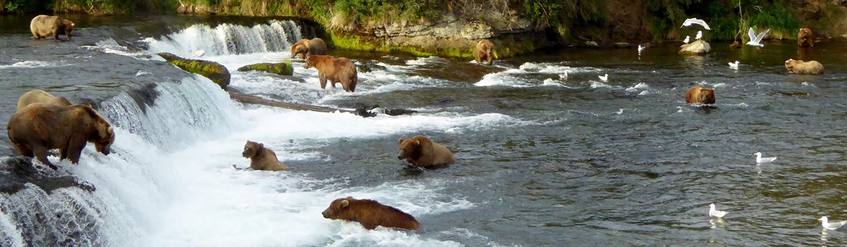
Katmai's awesome natural powers confront us not only as volcanics but as brown bears. In summer, North America's largest land predators gather at streams to feast on salmon runs, build weight from this wealth of protein and fat, and prepare for the coming long winter. Alaska's brown bears and grizzlies are now considered one species. Generally, grizzlies are those living 100 miles or more inland. Browns are bigger than grizzlies thanks to their rich fish diet. The Kodiak brown bear is a subspecies geographically isolated on Kodiak Island in the Gulf of Alaska. Mature male bears in Katmai may weigh up to 900 pounds.
Mating occurs from May to mid-July, with the cubs born in dens in mid-winter. Up to four cubs may be born, at a mere one pound each. Cubs stay with the mother for two years, during which she does not reproduce. The interval between litters is usually three years. Brown bears dig a new den each year, enter it in November, and emerge in April. About half of their lifetimes is spent in dens. Because each bear is an individual, how that bear will act in given situations cannot be predicted with any precision. These great and awe-inspiring bears symbolize the wildness of today's Katmai.
Volcanics
The 15 active volcanoes lining Shelikof Strait make the park and preserve one of the world's most active volcanic centers. These Aleutian Range volcanoes are like pipelines into the fiery cauldron beneath Alaska's southern coast, a cauldron that extends down both Pacific Ocean shores. This Pacific Ring of Fire boasts over four times more volcano eruptions above sea level than elsewhere in historic times.
Nearly 10 percent of the 400-plus eruptions took place in Alaska; less than two percent in the rest of North America. Plate tectonics theory attributes this to collisions of the plates making up the Earth's crust. The ring of fire marks edges where crustal plates bump against each other. A map of earthquake activity superimposed on a map of active volcanoes will show violent earth changes ringing the Pacific Ocean from South America around to and down the Indonesian archipelago.
Major eruptions deposited ash across the Katmai area at least 10 times in the past 7,000 years. Under the now quiet floor of the Valley of Ten Thousand Smokes, and deep beneath mountains around it, molten rock is still present. The most visible clues to this are the steam plumes rising occasionally from Mounts Mageik and Martin and Trident Volcano. The plumes show the potential for new eruptions to occur. Trident erupted in 1968, and Four-peaked Mountain awoke from 10,000 years of dormancy in fall 2006.
A volcanic eruption capable of bringing major change could occur at any time in this dynamic landscape. Since the great 1912 eruption, the resulting massive deposits of volcanic ash and sand have consolidated into tuff, a type of rock. In the valley, streams rapidly cut through these ash deposits to form steep-walled gorges. The thousands of fantastic smoking fumaroles that greeted the scientists entering the Valley of Ten Thousand Smokes after that powerful eruption have now cooled and ceased their ominous smoking. But the fiery cauldron—whose intense heat and pressure can be forcefully released to alter the landscape in mere hours—still lurks near the surface in the park's part of the volcanic Aleutian Range.
Wildlife
Another predictable eruption takes place each year as salmon burst from the northern Pacific Ocean into park waters. Sockeye (red) salmon return from the ocean—where they have just spent two or three years—to the headwater gravel beds of their birth. Their size averages five to seven pounds, varying proportionally to how long they have spent feeding at sea.
The salmon run begins in late June. By the end of July a million fish may have moved from Bristol Bay into the Naknek system of lakes and rivers. Salmon stop feeding when they enter fresh water, and body changes lead to their distinctive red color, humped back, and the elongated jaw they develop when they spawn—in August, September, and October. Stream bottoms must have the correct texture of loose gravel for eggs to develop. The stream must flow freely through winter to aerate the eggs. By spring the young fish, called fry, emerge from the gravels and move into the larger lakes, to live there two years. Then the salmon migrate to sea, returning in two or three years to repeat the cycle. Salmon are food for bears, bald eagles, rainbow trout, and—directly or indirectly—for other creatures who forage along these streams. They also have been important to Katmai people for several thousand years, and commercial fishing—outside the park—still anchors the local economies today.
Lake edges and marshes are nesting sites for tundra swans, ducks, loons, grebes, and a 20,000-mile annual commuter, the arctic tern. Sea birds abound along the coast, grouse and ptarmigan live in uplands, and some 40 songbird species summer here. Seacoast rock pinnacles and lakeshore treetops are nest sites for bald eagles, hawks, falcons, and owls. Brown bears and moose live in both coastal and lake regions. Moose feed on willows, water plants, and grasses. Caribou, red fox, wolf, lynx, wolverine, river otter, mink, marten, weasel, porcupine, snowshoe hare, red squirrel, and beaver all live here. At the coast are sea lions, sea otters, and hair sea ls, with beluga, orca, and gray whales sometimes using Shelikof Strait.
People
People have been coming to the place we call Katmai or thousands of years. Some found a good life in the heart of the park near the present-day Brooks River. Others made their lives on islands and shores of the rugged Shelikof Strait. The Alaska Peninsula's rich natural resources brought these people to this land of fierce storms, high seas, and steaming volcanoes.
Streams filled with salmon, tundra plains covered with migrating caribou, and ocean shores teeming with life were the attraction. Some came to stay, building partially underground homes to protect them from the howling winds and frigid winter temperatures. Others came to take advantage of rich summer salmon runs, building summer shelters but retreating from the mountains for winter. Many traveled through the park, crossing from the east side of the peninsula to Bristol Bay. The trail over Katmai Pass was not only a link between peoples but a route that gave access to a greater variety of food sources and to a rich sharing of both stories and cultures.
For over 9,000 years people have called Katmai home. Concentrations of prehistoric sites in the Brooks River and Amalik Bay areas are recognized as national historic landmarks. Several other prehistoric and historic sites are listed on the National Register of Historic Places, including the Savonoski Archeological District. Today the abundant natural resources of Katmai National Preserve provide critical food supplies for descendants of those earliest inhabitants. Native Alaskans who live a subsistence lifestyle harvest fish and game here, intimately linking their lives with the life of this land.
Eruption! And the Valley of Ten Thousand Smokes
It was apparently a nameless valley when the 20th century's most dramatic volcanic episode happened. Robert Griggs, exploring the volcano's aftermath for the National Geographic Society four years later, stared awestruck off Katmai Pass across the valley's roaring landscape riddled by thousands of steam vents. And so Griggs named it The Valley of Ten Thousand Smokes.
The June 1912 eruption of Novarupta Volcano dramatically altered the Katmai area. Severe earthquakes rocked the area for a week before Novarupta exploded with cataclysmic force. Enormous quantities of hot, glowing pumice and ash were ejected from Novarupta and nearby fissures. This material flowed over the terrain, destroying all life in its path. Trees upslope were snapped off and carbonized by blasts of hot wind and gas.
For several days ash, pumice, and gas were ejected. A haze darkened the skies over most of the Northern Hemisphere. When the eruptions subsided, over 40 square miles of once lush green land lay buried by volcanic deposits that were up to 700 feet deep. In nearby Kodiak, for two days you could not sea lantern held at arm's length. Acid rain caused clothes to disintegrate on the clothesline in distant Vancouver, Canada. The eruption was over 10 times stronger than the eruption of Mount Saint Helens in 1980. Eventually Novarupta fell dormant again. In the formerly lush valley, gas and steam escaped from the countless small holes and cracks in the volcanic ash deposits.
"The whole valley as far as the eye could reach was full of hundreds, no thousands—literally, tens of thousands—of smokes curling up from its fissured floor," Robert Griggs wrote in 1916. A thousand steam vents reached 500 feet in the air, with some reaching over 1,000 feet.
Just two eruptions in historic time—Greece's Santorini in 1500 BCE (Before Common Era) and Indonesia's Mount Tambora in 1815—displaced more volcanic matter than Novarupta. The 1883 eruption of Krakatoa, also in Indonesia, belched out just over half as much yet killed 35,000 people. The vastly isolated Novarupta's eruption killed no one. Had it occurred on New York City's Manhattan Island, Robert Griggs calculated, people in Chicago would hear it plainly. The fumes would tarnish brass in Denver. Acidic raindrops would burn your skin in Toronto. In Philadelphia the ash would lie nearly as deep as this brochure is wide. Manhattan would have zero survivors.
Today you can make the trip from Brooks Camp out to the Valley of Ten Thousand Smokes, where a turbulent Ukak River and its tributaries are still at work cutting deep gorges in accumulated volcanic ash. The landscape slowly recovers. In the natural world of stupendous Earth forces, destruction often leads to creation of new life and new landscapes.
What Blew?
Robert Griggs thought Mount Katmai had blown—he found its new crater lake. But it was Novarupta Volcano that blew. A deeper source of magma intersected Mount Katmai's older magma chamber and the surface, so that both erupted through Novarupta ("new eruption")—and caused Mount Katmai's summit to collapse.
Access and Information
Katmai National Park and Preserve lies on the Alaska Peninsula 290 miles southwest of Anchorage. Scheduled flights connect Anchorage with King Salmon daily, six miles from the park's west boundary. Commercial float planes go daily between King Salmon and Brooks Camp, June-September. Year-round air charters are available in King Salmon. The nonprofit Alaska Geographic Association sells books and maps at www.akgeo.org and at the Brooks Camp and King Salmon visitor centers.
Private Lands Private inholdings and Native village corporation lands exist in the park and preserve. You must get owner permission before using these lands. Of special concern are properties at the Kukaklek Lake outlet, the head and upper end of the Alagnak River, and the outlet area of Naknek Lake.
Weather Be prepared for storms and some sunshine. Summer days range from the mid-50s to mid-60s°F; average low is 44. Strong winds often sweep the area. Skies are clear 20 percent of the summer. Light rain can last for days.
Accessibility We strive to make our facilities, services, and programs accessible to all. For information go to a visitor center, ask a ranger, call, or check our website.
Firearms Hunting, or discharging any weapon, is prohibited in the national park. Hunting—under Alaska State law—and carrying firearms are allowed in the national preserve only. For firearms regulations check the park website.
Accommodations and Services
A concessioner offers meals and lodging at Brooks Camp from about June 1 to mid-September (lodging reservations required). Private lodges offer meals and lodging in King Salmon. Limited camping and food supplies and fishing tackle are sold at Brooks Lodge. Commercial operators provide air taxi, flightseeing, backpacking, canoe, and fishing guide services in the park and preserve. Visit the park's website for a list. The National Park Service conducts guided walks and evening programs at Brooks Camp in summer.
Seeing Katmai A 23-mile dirt road leads from Brooks Camp to the Valley of Ten Thousand Smokes. A foot trail descends to the valley from road's end. A concessioner's bus makes daily round-trip excursions to the valley from Brooks Camp. Charter aircraft at King Salmon, Homer, Kodiak, and Brooks Camp offer scenic flights. In good weather you may see bays, fjords, and waterfalls on the coast, glacier-clad mountains' steaming volcanic peaks, and island-studded lakes. You may fly over the Valley of Ten Thousand Smokes and site of the 1912 eruption.
Backcountry Travel Katmai's rugged wilderness requires reasonable precautions. Be well prepared and equipped. There are several good short routes and unlimited opportunities for long trips. Katmai has few trails, but passable routes are found along river bars, lakeshores, and gravel ridges. For overnight Valley hikes, arrange a bus drop-off and pick-up.
Hiking Safety Cold winds and icy waters are hazards. Your gear must withstand blowing rain and high winds of 50-60 mph. Carry extra dry clothing. Read up on hypothermia symptoms and their treatment. Be prepared to wait out storms: carry matches, a first aid kit, and emergency food. Rains or melting glaciers can make stream crossings impossible. You need sneakers and hiking boots here. Be extremely cautious when crossing muddy waters. Streams rise quickly with rainstorms or heavy glacial melt.
Camping Backcountry users must store food properly. Bear-resistant containers are available in limited supply at Brooks Camp Visitor Center or King Salmon. There are no improved campsites or food caches in the backcountry. Brooks Camp Campground (fee charged; reservations required in advance of arrival) has water, vault toilets, a food storage cache with limited space, and picnic tables. Cooking is allowed on camp stoves only. The concessioner sells white gas for stoves. Meals are available at Brooks Lodge; otherwise bring all your food with you.
Regulations and Safety
 (click for larger map) |
Camping and Food Storage Within 1.5 miles of Brooks River Falls camping is allowed only in the established campground. All food and gear must be secured in a building or in an approved bear-resistant container. Within Brooks Camp, picnicking (the consuming of food) is permitted in designated areas only.
Fishing An Alaska fishing license is required; all state rules apply. Sport fishing is allowed in the park using only artificial lures; fly fishing only from Lake Brooks to the Brooks River foot bridge. Release a fish or cut your line when a bear approaches. For current information and special regulations, please refer to the official State of Alaska fishing regulations or ask at the visitor center.
Boating Safety State and federal boating regulations apply. Water conditions change rapidly with little warning. Kayaks or canoes are safer traveling near shore. Watch the weather and stay ashore in rough water conditions.
Bears and Other Large Mammals Persons may not intentionally approach or remain within 50 yards of a bear or any large mammal, except when on the bear-viewing platforms.
Bear Warming Katmai is a wildlife sanctuary. Bears, moose, and other animals are unpredictable and can be dangerous. Read and study the park leaflet about bears. Ask any ranger about special precautions for backcountry camping, fishing, camping, and hiking. Do not continue to fish near bears. At Katmai brown bears may come very close to you. The safety of yourself, others, and the bears depends upon you.
Source: NPS Brochure (2018)
|
Establishment
Wilderness — December 2, 1980 |
For More Information Please Visit The  OFFICIAL NPS WEBSITE |
Documents
2011 Katmai National Park Butterfly Surveys: Brooks Camp and Lake Camp NPS Natural Resource Data Series NPS/AKR/NRDS—2012/411 (Sherri Anderson and Carissa Turner, December 2012)
A Biological Survey of Katmai National Monument (Victor H. Cahalane, Smithsonian Miscellaneous Collections, Vol. 138 No. 5, August 20, 1959)
A Chemical Study of the Fumaroles of the Katmai Region National Geographic Society Katmai Series No. 2 (E.T. Allen and E.G. Zies, 1923)
A Naknek Chronicle: Ten Thousand Years in a Land of Lakes and Rivers and Mountains of Fire, Katmai National Park and Preserve (Don E. Dumond, September 2005)
Acoustic Bat Monitoring in Alaska National Parks 2016-2018 NPS Natural Resource Report NPS/AKRO/NRR-2020/2096 (Paul A. Burger, March 2020)
Acoustic Inventory 2015-2017: Katmai National Park and Preserve NPS Natural Resource Report NPS/NRSS/NSNSD/NRR-2020/2080 (Davyd Halyn Betchkal, February 2020)
An Inventory of Paleontological Resources from Katmai National Park and Preserve, Southwest Alaska (Robert B. Blodgett, Vincent L. Santucci and Justin S. Tweet, from New Mexico Museum of Natural History and Science Bulletin No. 74, 2016, ©New Mexico Museum of Natural History and Science, all rights reserved)
Assessment of Coastal Water Resources and Watershed Conditions at Katmai National Park and Preserve (Alaska) NPS Natural Resource Technical Report NPS/NRWRD/NRTR-2007/372 (Sonia Nagorski, Ginny Eckert, Eran Hood and Sanjay Pyare, June 2007)
At the Heart of Katmai: An Administrative History of the Brooks River Area with Special Emphasis on Bear Management in Katmai National Park and Preserve 1912-2006 NPS Resource/Resource - Management Report NPS/AR/CRR/2013-77 (Katherine Ringsmuth, 2013)
Bear Management Plan, Katmai National Park and Preserve (1986)
Bears of Brooks River: A Guide to Their Identification, Lives, and Habits — 2010 • 2014 • 2015 • 2016 • 2017 • 2018 • 2019 • 2021 • 2022
Bridge Traffic Monitoring 2011, Katmai National Park NPS Natural Resource Data Series NPS/KATM/NRDS—2013/590 (Sherri A. Anderson, Carissa N. Turner and Troy R. Hamon, November 2013)
Brooks River Area: Final Development Concept Plan/Environmental Impact Statement (July 1996)
Brooks River Visitor Access: Final Environmental Impact Statement (January 2013)
Brown Bears of Brooks Camp (Roy Wood, 2012)
Building in an Ashen Land: Historic Resource Study of Katmai National Park and Preserve (HTML edition) (Janet Clemens and Frank Norris, 1999)
Buried Dreams: The Rise and Fall of a Clam Cannery on the Katmai Coast (Katherine Johnson, December 2002)
Coastal Observations of Seabird Mortality in Katmai National Park, Alaska: 2012-2021 NPS Natural Resource Report NPS/KATM/NRR-2023/2563 (Rylee Jensen, Ellisif Cline and Kelsey Griffin, September 2023)
Cultural Landscape Report: Valley of Ten Thousand Smokes Road Historic District, Katmai National Park and Preserve, King Salmon, AK (David T. Gilbert, MIG. Inc., September 2022)
Distributions of Fishes in Fresh Water of Katmai National Monument, Alaska, and Their Zoogeographical Implications Special Scientific Report--Fisheries No. 590 (William R. Heard, Richard L. Wallace and Wilbur L. Hartman, October 1969)
Earth Movements Accompanying the Katmai Eruption (Clarence N. Fenner, extract from The Journal of Geology, Vol. 33 No. 2, February-March 1925)
Earth Movements Accompanying the Katmai Eruption. II (Clarence N. Fenner, extract from The Journal of Geology, Vol. 33 No. 3, April-May 1925)
Ecological Land Survey and Soils Inventory for Katmai National Park and Preserve, 2016-2017 NPS Natural Resource Report NPS/KATM/NRR-2021/2298 (Aaron F. Wells, Tracy Christopherson, Gerald V. Frost, Matthew J. Macander, Susan L. Ives, Robert W. McNown and Erin K. Johnson, August 2021)
Embattled Katmai: A History of Katmai National Monument (John A. Hussey, August 1971)
Eruption of Trident Volcano, Katmai National Monument, Alaska, February-June 1953 (HTML edition) USGS Circular 318 (George L. Snyder, 1954)
Evaluation of the Bear Viewing Experience and Associated Thresholds at Katmai National Park and Preserve and Lake Clark National Park and Preserve: 2017-2020 (Matthew T.J. Brownlee and Ryan L. Sharp, 2020)
Foundation Statement, Katmai National Park and Preserve, Alaska (December 2009)
Foundation Document Overview, Katmai National Park and Preserve, Alaska (January 2016)
Fure's Cabin, Historic Structure Report, Bay of Islands, Naknek Lake Katmai National Park & Preserve (HTML edition) (Joaqlin Estus, Harvey M. Shields and David E. Snow, 1984)
Historic Structure Report: Fure's Cabin (FFA Architecture and Interiors, Inc., 2024)
Geodetic Studies in the Novarupta Area, Katmai National Park, Alaska, 1990 to 1995 USGS Professional Paper 1574 (Julie A. Dumoulin and John E. Gray, 1997)
Geologic Map of the Katmai Volcanic Cluster, Katmai National Park, Alaska USGS IMAP 2778 (Wes Hildreth and Judy Fierstein, 2002)
Geologic Resources Inventory Report, Katmai National Park and Preserve and Alagnak Wild River NPS Natural Resource Report NPS/NRSS/GRD/NRR-2016/1314 (Chad P. Hults and Judy Fierstein, September 2016)
Geology of the Mount Katmai area, Alaska USGS Bulletin 1058-G (A. Samuel Keller and Hillard N. Reiser, 1959)
Historic Structure Report: Field Laboratory — Brooks Lake, Alaska (Kathleen Wackrow, 2018)
Hot Springs of the Valley of Ten Thousand Smokes (E. G. Zies, extract from The Journal of Geology, Vol. 32 No. 4, May-June 1924)
Interactions of Brown Bears, Ursus arctos, and Gray Wolves, Canis lupus, at Katmai National Park and Preserve, Alaska (Tom S. Smith, Steven T. Partridge and John W. Schoen, extract from The Canadian Field-Naturalist, Vol. 118 No. 2, 2004, ©The Ottawa Field-Naturalists' Club)
Invasive Species Management for Katmai National Park & Preserve
Invasive and Exotic Species Management for Katmai National Park & Preserve: 2010 Summary Report NPS Natural Resource Data Series NPS/KATM/NRDS—2010/107 (Crystal Shepherd and Devin Bartley, November 2010)
Invasive Species Management in Katmai National Park & Preserve: 2011 Summary Report NPS Natural Resource Data Series NPS/KATM/NRDS—2011/222 (Peter Frank and Arielle Woods, December 2011)
Invasive Species Management for Katmai National Park & Preserve, Alagnak Wild River, and Aniakchak National Monument & Preserve: 2012 Summary Report NPS Natural Resource Data Series NPS/KATM/NRDS—2013/429 (Allison Connealy and Claire Parker, January 2013)
Invasive Species Management for Katmai National Park & Preserve, Alagnak Wild River, and Aniakchak National Monument & Preserve: 2013 Summary Report NPS Natural Resource Data Series NPS/KATM/NRDS—2014/672 (Nicole Landry and Aleksandra Voznitza, June 2014)
Invasive Species Management for Katmai National Park & Preserve, Alagnak Wild River, and Aniakchak National Monument & Preserve: 2014 Summary Report NPS Natural Resource Data Series NPS/KATM/NRDS—2015/747 (Victoria Anderson and Alex Lindsey, January 2015)
Invasive Species Management for Katmai National Park & Preserve, Alagnak Wild River, and Aniakchak National Monument & Preserve: 2015 Summary Report NPS Natural Resource Report NPS/KATM/NRR—2015/1096 (Jordon C. Tourville and Melissa S. Armstrong, December 2015)
Invasive Species Management for Katmai National Park & Preserve, Alagnak Wild River, and Aniakchak National Monument & Preserve: 2016 Summary Report NPS Natural Resource Report NPS/KATM/NRR—2016/1349 (Christine A. DeVries and Nicole E. Zampieri, December 2016)
Invasive Species Management for Katmai National Park & Preserve, Alagnak Wild River, and Aniakchak National Monument & Preserve: 2017 Summary Report NPS Natural Resource Report NPS/KATM/NRR—2018/1624 (Stephen B. Caron and Jessica L. Westbrook, April 2018)
Invasive Species Management for Katmai National Park & Preserve, Alagnak Wild River, and Aniakchak National Monument & Preserve: 2018 Summary Report NPS Natural Resource Report NPS/KATM/NRR—2020/2094 (Kayla Sherman and Thomas Hatton, March 2019)
Invasive Species Management for Katmai National Park & Preserve, Alagnak Wild River, and Aniakchak National Monument & Preserve: 2019 Summary Report NPS Natural Resource Report NPS/KATM/NRR—2020/2130 (Lillian Setters and Shayla Ramos, May 2020)
Isolated Paradise: An Administrative History of the Katmai and Aniakchak NPS Units, Alaska (HTML edition) (Frank B. Norris, 1996)
Journeys at Katmai: An Activity Book for Not-So-Junior-Rangers (Date Unknown; for reference purposes only)
Junior Ranger Adventures, Katmai National Park (Date Unknown; for reference purposes only)
Katmai National Park and Preserve landcover mapping project final report NPS Natural Resource Technical Report NPS/KATM/NRTR—2003/002 (K. Stumpf, 2003)
Katmai National Park and Preserve Visitor Study: Summer 2006 Park Studies Unit Visitor Services Project Report 182 (Margaret A. Littlejohn and Steven J. Hollenhorst, University of Idaho, June 2007)
Katmai National Park & Preserve Visitor Study: Summer 2014 SESRC Technical Report 15-023 (Matthew Strawn and Yen Le, Washington State University, 2015)
Lake Temperature Monitoring in Southwest Alaska Parks: A Synthesis of Year-Round, Multi-Depth Data from 2006 through 2018 NPS Natural Resource Report NPS/SWAN/NRR-2020/2191 (Krista K. Bartz and Paul W.C. Gabriel, November 2020)
Landcover classes, ecoregions and plant associations of Katmai National Park and Preserve NPS Natural Resource Technical Report NPS/KATM/NRTR—2003/001 (K. Boggs, et al., 2003)
Landcover Mapping Project: Final Report, Katmai National Park and Preserve NPS Natural Resource Technical Report NPS/KATM/NRTR—2003/002 (Ken Stumpf, June 2003)
Long-Range Interpretive Plan, Katmai National Park and Preserve, Aniakchak National Monument and Preserve, Alagnak Wild River (December 2009)
Long-term Ecological Monitoring Proposal, Katmai National Park and Preserve, Alaska (Rick Potts, October 1993)
Mammals of the Katmai National Monument, Alaska (Everett L. Schiller and Robert Rausch, extract from Arctic, Vol. 9 No. 3, 1956)
Marine Debris Presence on Beaches in Katmai National Park and Aniakchak National Monument and Preserve NPS Natural Resource Report NPS/KATM/NRR-2023/2527 (Rylee Jensen, Ellisif Cline and Kelsey Griffin, June 2023)
Mesozoic Macrofossil Locality Information for the Mount Katmai and Part of the Afognak Quadrangles, Alaska USGS Open-File Report 93-713 (William P. Elder and John W. Miller, 1993)
Modeling the Effects of Hunan Activity on Katmai Brown Bears (Ursus arctos) through the Use of Survival Analysis (Tom S. Smith and B. Alan Johnson, extract from Arctic, Vol. 57 No. 2, June 2004)
Monitoring Coastal Salt Marshes in the Lake Clark and Katmai National Parklands of the Southwest Alaska Network NPS Natural Resource Technical Report NPS/SWAN/NRTR—2010/338 (M. Torre Jorgenson, Gerald V. Frost, Amy E. Miller, Page Spencer, Michael Shephard, Buck A. Mangipane, Claudette Moore and Charles Lindsay, June 2010)
Monitoring Responses to Climate Change in Southwest Alaska (February 2010)
Monitoring Vegetation Change in Coastal Marshes of Southwest Alaska, 2007-2018 NPS Natural Resource Report NPS/SWAN/NRR-2020/2202 (Michael P. Hannam, Amy E. Miller and James K. Walton, December 2020)
National Park Service Katmai landcover mapping spectral database modeling and final map compilation NPS Natural Resource Technical Report NPS/KATM/NRTR—2003/003 (J. Grunblatt, 2003)
National Register of Historic Places Nomination Forms
Archeological Site 49 Af 3 (Charles P. Bohannon, September 11, 1975)
Archeological Site 49 Mk 10 (Charles P. Bohannon, September 10, 1975)
Brooks River Archeological District (49 MK 1) (Charles P. Bohannon, August 25, 1975)
Fure's Cabin (Bonnie Stevens Houston, November 21, 1988)
Kaguyak Village Site (49 Af 4) (Charles P. Bohannon, August 29, 1975)
Kukak Cannery Archeological Historic District (Katherine Johnson, June 24, 2002)
Kukak Village Site (49 Mk6 ) (Charles P. Bohannon, c1976)
Old Savonoski (49 Mk 2) (Charles P. Bohannon, September 18, 1975)
Savonoski River Archeological District (Charles P. Bohannon, September 10, 1975)
Savonoski River Archeological District (boundary increase) (Rachel Myron, December 27, 2001)
Takli Island Archeological District (Charles P. Bohannon, September 5, 1975)
Natural Resource Condition Assessment, Katmai National Park and Preserve and Alagnak Wild River NPS Natural Resource Report NPS/SWAN/NRR-2015/1095 (Jacob Zanon, Mike R. Komp, Jon Sopcak, Kevin M. Benck, Kathy Allen, Kevin J. Stark, Lonnie J. Meinke, Andrew Robertson and Barry Drazkowski, December 2015)
Orthorectification of Historic Imagery for Lake Clark National Park and Preserve and Katmai National Park and Preserve NPS Natural Resource Technical Report NPS/SWAN/NRTR-2014/864 (Andrew Robertson, Jeffrey Knopf, David Johnson and Bonnie Maffitt, April 2014)
Park Newspaper (The Novarupta): 2007 • c2009 • 2014 • 2016 • 2017 • 2018 • 2019 • 2021 • 2022
Preliminary Volcano-Hazard Assessment for the Katmai Volcanic Cluster, Alaska USGS Open-File Report 2000-489 (Judy Fierstein and Wes Hildreth, 2000)
Principal facts for 63 gravity stations in the vicinity of Katmai National Park, Alaska USGS Open-File Report 92-310 (R.W. Saltus, 1992)
Refining Monitoring Protocols to Survey Brown Bear Populations in Katmai National Park and Preserve and Lake Clark National Park and Preserve NPS Natural Resources Technical Report NPS/AR/NRTR/2007-66 (Tamara L. Olson and Judy A. Putera, November 2007)
Resource Management News: 2012 • 2013 • 2014 • 2015 • 2016 • 2017 • 2018 • 2019 • 2020 • 2021 • 2022
Spatio-Temporal Distribution of Coastal Brown Bears and Visitors in Katmai National Park, Alaska NPS Natural Resource Report NPS/KATM/NRR-2021/2216 (Kelsey R. Griffin, January 2021)
Story of a House (Don E. Dumond, October 2008)
The Fumarolic Incrustations in the Valley of Ten Thousand Smokes National Geographic Society Katmai Series No. 3 (E.G. Zies, 1924)
The Economic Contribution of Bear Viewing to Southcentral Alaska (Taylor B. Young and Joseph M. Little, May 2019)
The Katmai Region, Alaska, and the Great Eruption of 1912 (Clarence N. Fenner, extract from The Journal of Geology, Vol. 28 No. 7, October-November 1920)
The Origin and Mode of Emplacement of the Great Tuff Deposit of the Valley of Ten Thousand Smokes National Geographic Society Katmai Series No. 1 (Clarence N. Fenner, 1923)
The Valley of Ten Thousand Smokes (Robert F. Griggs, 1922)
Tourism in Katmai Country: A History of Concessions Activity in Katmai National Park and Preserve (Frank B. Norris, 1992 w/2004 corrections)
Tree-ring Reconstruction of Historic Insect Outbreaks in Lake Clark and Katmai National Parks and Preserves: Final Report NPS Natural Resource Technical Report NPS/SWAN/NRTR—2011/482 (Rosemary Sherriff and Ed Berg, August 2011)
Water Resources Information and Issues Overview Report: Katmai National Park and Preserve, Alagnak Wild River NPS Natural Resource Technical Report NPS/NRPC/WRD/NRTR—2007/057 (Jenny Biggs, Rusty Myers, Page Spencer, Linda Stromquist, Don Weeks and Jeff Bennett, October 2007)
Wildlife Monitoring Plan, Katmai National Park and Preserve (1984)
Wildlife Observations 2011 Katmai National Park & Preserve, Alaska NPS Natural Resource Data Series NPS/KATM/NRDS—2011/615 (Sherri Anderson and Troy Hamon, February 2014)
Witness: Firsthand Accounts of the Largest Volcanic Eruption in the Twentieth Century (Jeanne M. Schaaf, 2004)
katm/index.htm
Last Updated: 01-Jan-2025