|
Redwood National Park & State Parks California |
|
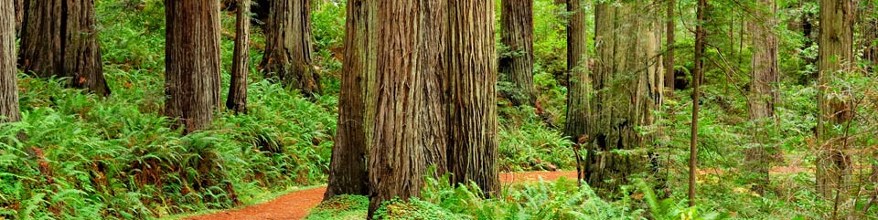 NPS photo | |
World's tallest living tree—monarch of the North Coast—living link to the Age of Dinosaurs. Redwoods grow from seeds the size of a tomato seed yet can weigh 500 tons and stand taller than the Statue of Liberty. Its foot-thick bark makes the tree all but impervious to fire and insects. Archibald Menzies first noted the coast redwood for western science in 1794. Its scientific name. Sequoia sempervirens (ever living), probably honors Cherokee leader Sequoyah. In 1918 paleontologists wanting to save this living link to our evolutionary past campaigned nationally to protect the trees. Three California redwoods state parks resulted: Prairie Creek (1923), Del Norte (1925), and Jedediah Smith (1929). To preserve the trees' natural Coast Range setting and associated plants and animals. Redwood National Park was created in 1968 and expanded in 1978. The national park boundary encircled the three state parks to better protect superlative ancient redwood forests. In 1994 the National Park Service and California Department of Parks and Recreation began managing the parklands cooperatively, aiming to manage the parks the same. That's why you see rangers in state and national park uniforms anywhere in the parks, working for the same mission. The parks' designation as a World Heritage Site and part of the California Coast Ranges Biosphere Reserve reflects their worldwide recognition as irreplaceable treasures. Here, the diversity of life is protected for you and for future generations. Help us safeguard this special place by treating it with care and respect.
From Exploration to Preservation
In 1800 redwood forests probably covered two million acres. As mid-1800s gold fever subsided here, redwood fever replaced it. Seeming endless at first, the trees soon fell to determined logging. The State of California preserved some key groves in the 1920s. Congress created Redwood National Park in 1968 to protect the world's tallest trees and Redwood Creek's salmon fishery.
The 1978 park expansion provided a buffer zone between the park and logging upstream on private lands and a watershed restoration program to remove logging roads and rehabilitate thousands of acres of cut-over land. Redwood National and State Parks protect nearly 40,000 acres of ancient forest, almost half of all that remain.
Jedediah Strong Smith
Lacking good deep harbors, the redwood coast drew little attention until fur trapper Jed Smith arrived overland in 1828. Smith sought a better route between the Rockies and Pacific. Gold miners opened this area to settlement in the 1850s.Mining and Logging
California's northern coast was largely ignored by non-Indians until gold was discovered on Gold Bluffs Beach in 1850. Mining profits were marginal. Revived during the Civil War, the mines closed at the war's end. Various methods were tried later, but operations ceased by 1920. A few remains of mining operations still exist on Gold Bluffs Beach.Logging began in redwood country in 1851. At first small logs were floated to small mills or dragged by oxen on skid roads. Railroads were used in the 1870s, then the steam donkey in 1882 and bull donkey 10 years later. Bulldozers were used by the 1920s, trucks by the 1940s. Redwood lumber built some of San Francisco's great Victorian homes.
The Coast Redwood
Coast redwoods tower over all other trees in the world. Trees over 370 feet tall have been recorded across the region. Redwood forests develop the world's greatest reported volume of living matter per unit of land surface. Giant sequoias grow to larger diameters and bulk but do not grow as tall.Coast redwoods can live to about 2,000 years old; they average 500 to 700 years old. They have no known killing diseases and do not suffer significant insect damage.
Merely to stand in a redwood grove inspires many visitors to champion these trees' preservation.
Age: To 2,000 years
Bark: To 12 in. thick
Base: To 22 ft. diam.
Reproduce: By seed or sprout
Seed size: Like a tomato seed
Cone size: Like a large olive
Age: To 3,200 years
Bark: To 31 in. thick
Base: To 40 ft. diameter
Reproduce: By seed only
Seed size: Like an oat flake
Cone size: Like a chicken eggFrom Seed and Sprout
Redwood-like trees grew over much of the Northern Hemisphere in the Age of Dinosaurs. Later climate change reduced redwood habitat to this narrow, fog-bound coastal corridor.Coast redwoods reproduce by seed and by stump and basal sprouting. Seeds slightly bigger than a pinhead are released from mature cones that ripen in August and September. If a redwood is felled or is badly burned, a ring of new trees often sprouts from burls around the trunk's base. These so-called "family groups" are common. Saplings use the parent tree's root system.
Redwoods have no taproot; their roots penetrate only 10 t o 13 feet deep but spread out 60 to 80 feet.
Treasures of Nature and Culture
From sea level to 3,200 feet in elevation in the Coast Range, a mild, moist climate assures the parks an abundant diversity of wildlife. Elusive to visitors, many mammals, birds, amphibians, and insects live in the mature redwood forest. They depend on it for food and for shelter. Prairies form natural islands of grasslands, where wildlife abounds.
Roosevelt elk favor prairie and other open lands but seek forests for cover and shade. The parks' largest land mammals, elk may exceed 1,000 pounds.
Much bigger antlers distinguish them from black-tailed deer. Good places to see Roosevelt elk are Elk Prairie campground and Gold Bluffs Beach. Look for them along the Bald Hills and Davison roads, too. Be alert for elk crossing highways.
Prairies and Waterways
Prairies and rivers reflect the changing of seasons far better than redwood groves do.In springtime, prairie wildflowers burst with color that gives way in the dry summer to the grasslands' amber glow. Prairies are the realm of raptors, the predatory red-tailed hawk, kestrel, and great horned owl, and their prey of gophers and meadow mice.
Mountain lions, bobcats, coyotes, foxes, elk, and black-tailed deer frequent prairies kept free of trees by prescribed fire and grazing elk.
Acorn-bearing Oregon white oaks edge prairies at the higher elevations. Oaks provided protein-rich food for Indians, who cleared the understory with fire. Prairies make good birding spots. There you may see the goldfinch, junco, quail, or raven.
The parks' rivers are world-renowned for fishing and loved for recreation and their sheer beauty. The Smith River, named for Jedediah Smith, arises in the Siskiyou Mountains and then flows through the parks' northern section. It is now California's last major free-flowing river and is famous for salmon and steelhead.
The Klamath River, also a salmon and steelhead stream, crosses the midsection of the parks.
Redwood Creek flows through the parks' southern part. Salmon and steelhead populations were severely diminished by past logging in the Redwood Creek watershed.
Black Bears
Seldom seen, black bears roam these parks. Most haven't lost their fear of humans. Fond of acorns, bears travel far to harvest them. To prevent wild bears from becoming problem bears we must keep human food away from them. Use sound food storage practices. Counter-balance all food, scented items—soap, toothpaste, lotion—and garbage in a tree 200 feet from camp; 12 feet up and 10 feet out from the trunk; and five feet down from the branch. Ask a park ranger about how to store your food.Remember: A bear seeking food from human camps can be aggressive and may have to be destroyed. Please keep wildlife wild.
Watershed Protection
Congress expanded the national park in 1978 and directed the National Park Service to rehabilitate logged-over lands. Bulldozers re-contoured hillsides and stream channels to restore conditions that favor return of natural vegetation. Congress also created a 30,000-acre protection zone upstream from the park in Redwood Creek's watershed. This limits effects of the timber harvesting there on the park downstream.
Indians of the Redwood Coast
American Indians have lived along the redwood coast for thousands of years. Belonging to several different groups, they speak different languages, despite living in a relatively small area. Before non-Indian people arrived in the 1850s, Indian villages, with their split-plank structures, dotted the coast and lined major rivers.
Travel was by redwood dugout canoes on waterways and by foot on an elaborate trail system. Foods varied with the seasons. They fished ocean and rivers, hunted land and marine mammals, and gathered nuts, seeds, and berries. American Indians today live on and off reservation lands and represent five to 10 percent of the local population. Groups are represented by sovereign governments and many traditions continue.
Some members still speak the languages. Traditional ceremonies are held, hunting and fishing are still important, and the traditional arts and crafts are kept alive.
Life Along the Seacoast
Even apart from the Coast Range and its lofty forests, the coastline here would justify national or state park status. Rugged and largely unaltered by humans, the coastline features stretches of steep and rocky cliffs broken by rolling slopes. Generally rocky, its tidal zone can be tough to traverse. Gold Bluffs Beach is an exception, with its seven-mile stretch of dunes and sandy beach. On the coastline you may discover a rich mix of forms of life that live in the distinct habitats illustrated below.
Many of the parks' animal species thrive along the coast. Brown pelicans are summer visitors. Cormorants take to lagoon or river and shore waters. Willets and sanderlings work the beach. Offshore may be Pacific gray whales in migration, seals, sea lions, dolphins, porpoises, and orca whales. In the intertidal areas the cycle of rising and falling tides has produced tightly zoned layers of life. To help protect these animals, the national park boundary extends one-quarter mile offshore.
Offshore
Between shore and the deep ocean here an average surface acre is as
productive as an acre of fertilized agricultural land. The basic wealth
lies in phytoplankton, single-celled plants.
Sea lions feed beyond the surf and haul out on shore or on sea stacks. Harbor seals swim in the surf and haul out in sheltered coves. Sea birds nest offshore on rocks.
The California Current flows south. It works with offshore winds to draw nutrients up from deep waters, providing food for many coastal creatures. Moisture-laden air off the California Current condenses as low clouds over cold water near shore.
Intertidal Zone
Tides rise and fall twice daily on a 25-hour lunar cycle. In the zone
between high and low tide, life forms arrange themselves vertically
based on tolerance for exposure to air and/or water and to heat and wave
shock. Other biological limits are predators and competition for food
and space.
A splash zone above high tide is home for periwinkle snails and beach hoppers that can withstand episodic wetting and wave shock. Splash zone species are transitional but more attuned to life on land than in the sea. Mussels cling to rocks in the high-tide zone, covered by water only at high tide. Shells let them tolerate temporary exposure to air and direct sunlight.
Seaweeds provide oxygen, food, and shelter for intertidal zone residents. Some kelp, anchored in deep water, with built-in floats, are tall as redwood trees.
Tidepools shelter life in rocky beach outcroppings. Tidepool dwellers cope with great changes in water temperature, salinity, and oxygen content. Here are barnacles, limpets, nudibranchs, ochre sea stars, sea urchins, and erect sea palms anchored by rootlike hold-fasts.
Beaches
Life on sandy beaches observes wet and dry zones, too, because of tides
and waves. The lower beach is often wetted while upper beaches are like
deserts between sea and lush coastal forest. Clams and mole crabs burrow
in wet lower beaches. Sanderlings follow retreating wave lines to forage
on washed-up organisms.
From Ocean to Forest
A marbled murrelet is a robin-sized seabird that flies deep into the
old-growth forest to lay its egg high in treetops on a large
moss-covered limb. Unfortunately, its ancient habitat has been greatly
reduced by forest fragmentation.
Most murrelets left in California nest in Redwood National and State Parks, but predators like ravens, jays, and crows are eating murrelet eggs and chicks. While circling the forest looking for food scraps at campgrounds, they find the murrelet's nest instead. Please help protect this rare bird—keep a clean campsite and avoid feeding any wildlife.
Sea Cliffs
Northern park beaches tend to be rocky and backed by sea cliffs.
Southern beaches tend to be backed by bluffs. Over half of the parks'
birds are marine species. Some nest—often as crowds—in sea
cliffs: murres, cormorants, puffins, auklets, gulls, and pigeon
guillemots.
The Role of Fog
As air warmed by inland heat passes over the cold, near-shore waters,
fog forms—in summer almost daily. Fog helps to approximate the
mild, moist climate that prevailed during the Age of Dinosaurs, when
redwood-like species grew over much of North America.
Fog brings the redwood forests relief from the dry summer, too. It reduces the loss of water through leaf surfaces. Fog collects on trees and then its precious moisture drops to the forest floor. Fog is not essential to redwoods, but its absence would reduce their range.
Woodlands
The Coast Range's west slope forests benefit from being close to the
ocean—for fog, rainfall, and moderated climate. Redwoods favor the
moist, north-facing slopes where sunlight's effects are less drying.
Rivers near sea level also provide hospitable flats for these big trees.
Redwood National Park is one of over 400 parks in the National Park
System.
Exploring the Redwood Coast
Redwood National and State Parks represent a cooperative management effort of the National Park Service and the California Department of Parks and Recreation. This includes Redwood National Park, Jedediah Smith Redwoods State Park, Del Norte Coast Redwoods State Park, and Prairie Creek Redwoods State Park. Together these parks are a World Heritage Site and an International Biosphere Reserve that protect resources cherished by citizens of many nations. Information in this brochure can help you decide what to see and do during the time you have to visit the parks. Services and facilities are also listed or described.
Emergencies call 911
Accessibility We strive to make our facilities, services, and programs accessible to all; call or check our website.
Hiouchi Area
Hiouchi Visitor Center
The visitor center, open year-round, offers a good place to begin your
visit to the national and state parks if you are approaching the north
end of the parks on US 199. Exhibits and interpretive publications tell
about the parks, their trees and coastline, and other related topics.
Trail maps are available.
Jedediah Smith Redwoods State Park
Here you can camp, picnic, hike, fish, swim, and float the Smith River.
There are no lifeguards. Interpretive exhibits and publications are
available at the visitor center. Interpretive walks and talks are
offered in summer.
Howland Hill Road, an alternate route to Crescent City, is an unpaved, narrow, scenic drive through the redwood forest. It provides entry to Stout Grove, hiking trails, a horseback riding trail, and the Howland Hill Outdoor School. Motor homes and trailers are not advised on this road. Walker Road, an unpaved scenic road through redwood forest, provides entry to Smith River and short hiking trails.
Crescent City Area
Park Headquarters
The headquarters for Redwood National and State Parks is at 1111 Second
Street in Crescent City. Information and interpretive publications are
available here year-round. Nearby attractions are the Battery Point
Lighthouse, Del Norte County Historical Museum, and the harbor at
Citizens Dock. You can get information about commercial attractions and
private campgrounds at the Chamber of Commerce on Front Street, across
the street from park headquarters.
Crescent Beach
Picnicking and walking on the beach are popular activities at Crescent
Beach, just two miles south of Crescent City off Enderts Beach Road.
Enderts Beach Road
The road leads to Crescent Beach Overlook, a good place to watch whales,
have a picnic, or just take in the scenery. A section of the Coastal
Trail (1.2 miles round-trip) follows tall bluffs, then drops to the
sandy Enderts Beach. The hike-in Nickel Creek backcountry camp (0.5
mile) just above the beach offers five sites with beach access. Free
permits required, available year-round from Crescent City Information
Center and Kuchel Visitor Center. Picnic tables, grills, and a pit
toilet are provided. There is no water. In summer 2- to 2.5-hour
tidepool or seashore walks are conducted, tides permitting. They begin
at the parking area, descend to the beach, and explore rocky tidepools
at its southern end.
Coastal Trail
Multiple sections of the Coastal Trail explore beaches, bluffs,
grasslands, former farm land, and redwood and other forests. With
substantial road links and other trails, the Coastal Trail enables you
to backpack nearly the length of the parks, from Enderts Beach Road in
the north to the Tall Trees Grove in the south. Backcountry camps are
provided at (north to south) Nickel Creek, DeMartin, and Flint Ridge.
There is a campground at Gold Bluffs Beach. Free backcountry permits are
required for all backcountry campsites. They are available from Kuchel
Visitor Center and Crescent City Information Center. For more
information on the Coastal Trail, ask at park information centers for
maps and publications.
Del Norte Coast Redwoods State Park
Here you can camp, hike, and backpack. Interpretive walks and talks are
offered in summer. Mill Creek campground is open in summer.
Klamath Area
False Klamath Cove
False Klamath Cove lies five miles north of the Klamath River. A
protected beach and picnic area are located at the mouth of Wilson
Creek.
Lagoon Creek
Picnic and enjoy the beach. The Yurok Loop Trail (one mile, one hour)
gradually climbs to the top of the sea bluffs for panoramic ocean views.
Look for wildflowers in season and, perhaps, views of sea mammals.
Requa Road
Requa Road leads from US 101 up to the Klamath River Overlook, some 600
feet above the estuary at the Klamath River's mouth. There the Coastal
Trail leads down to a spur trail leading to another overlook some 200
feet above the ocean. Whale-watching can be good in this area.
Coastal Drive
This narrow, scenic, partially paved drive (connect with Alder Camp Road
for an eight-mile, 30-minute, loop drive) winds through stands of
redwood, offering close looks at the Klamath River and breathtaking
views of crashing surf and the expansive Pacific Ocean. Don't miss the
World War II radar station. It looks like a farmhouse and barn—that
was its disguise in the 1940s. The smaller structure housed the power
supply. The operations building housed an oscilloscope and radar
technicians. Near the junction with Alder Camp Road the High Bluff
picnic area provides panoramic views of the coast from its location atop
the bluff. Another point of interest is the old Douglas Memorial Bridge
that was destroyed by flooding in 1964. Access sections of the Coastal
Trail from Coastal Drive or Alder Camp Road; find camping at Flint Ridge
backcountry camp. The Coastal Drive is a narrow and mostly unpaved road
with steep grades and sharp curves. Vehicles with trailers and motor
homes are prohibited.
Prairie Creek Area
Prairie Creek Redwoods State Park
From US 101 you can reach the park via the Newton B. Drury Scenic
Parkway, an eight-mile stretch of the original Redwood Highway that
provides one of the parks' most scenic drives through old-growth redwood
forest. You will find park information, exhibits, and interpretive
publications at the Prairie Creek Visitor Center. Camping is available
at Elk Prairie campground. Cal-Barrel Road is an unpaved scenic drive
through the redwood forest (trailers prohibited).
Davison Road provides entry to the Elk Meadow Day Use Area and Gold Bluffs Beach. Elk Meadow Day Use Area has picnicking, mountain biking, and hiking, including the 2.5-mile loop (1.5 hours) Trillium Falls Trail. Beyond Elk Meadow, Davison Road is narrow and unpaved. Trailers and trailer-vehicle combinations longer than 24 feet or wider than 8 feet are prohibited. Gold Bluffs Beach offers wildlife viewing, hiking, picnicking, camping, and entry to the beach and Fern Canyon. Watch out for elk herds. Danger: Elk are wild and unpredictable. Do not approach them on foot.
Lost Man Creek
Take the short, unpaved, scenic drive through the redwood forest.
Trailers are not advised. This area offers hiking and mountain
biking trails and picnicking facilities. Lost Man Creek Trail leads past
the World Heritage Site dedication area and on to a cascade on Lost Man
Creek. Continue past old-growth forest and into second-growth habitat,
11 miles one-way.
Orick Area
Bald Hills Road
Do not take trailers or motor homes on the steep—15
percent—grade here. Parking for trailers is available at the
Redwood Creek trailhead and Kuchel Visitor Center.
Walk the Lady Bird Johnson Grove self-guiding loop trail (1.5 miles, one hour), reached from Bald Hills Road. It threads through mature forest to the grove and site at which Lady Bird Johnson dedicated the national park in 1968.
A limited number of permits for private vehicles are issued on a first-come, first-served basis to reach the trailhead for the Tall Trees Grove. The free permits are available at Kuchel Visitor Center and Crescent City Information Center. Allow four hours round-trip from US 101 for driving to the trailhead and then hiking down to the grove (3.4 miles total: 1.3 miles down; an 0.8-mile loop at the bottom; 1.3 miles back up). The trail is steep, descending 726 feet into the grove where some of the world's tallest trees grow.
Redwood Creek Trail
The first 1.5 miles are accessible. Here you can combine hiking and
backcountry camping. Take an eight-mile hike to Tali Trees Grove, where
some of the world's tallest trees grow on the flats of Redwood Creek.
This involves two creek crossings. Caution: Bridges are provided in
summer only. During the rainy season high waters make stream crossings
dangerous. For current information on getting to Tall Trees Grove via
this route, ask a park ranger at an information station. Camping is
allowed only on gravel bars along Redwood Creek, and only upstream from
the confluence of McArthur Creek, 1.5 miles from the Redwood Creek
trailhead. Camping is not permitted within 0.25 mile of the Tall Trees
Grove. Free permits are required for camping along Redwood Creek. They
are available from Kuchel Visitor Center and Crescent City Information
Center.
Kuchel Visitor Center
If you are approaching the parks from the south, make this your first
stop. View the exhibits and browse publications that tell about the
area, its trees, coastline, and related topics. Trail maps are
available.
General Information
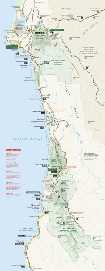 (click for larger map) |
Camping Facilities Developed campgrounds in Jedediah Smith Redwoods and Del Norte Coast Redwoods state parks have hot showers, restrooms, and disposal stations. Prairie Creek Redwoods State Park campgrounds provide heated showers and restrooms, but no disposal stations. Trailers up to 24 feet long and motor homes up to 27 feet are allowed, except at Gold Bluffs Beach where trailers are prohibited and motor homes up to 24 feet long are allowed. There are no trailer hookups in the parks. There are several primitive backcountry campgrounds for backpackers; some can also accommodate bicyclists, horses, and/or pack animals.
Reservations are usually necessary in summer. The nearest group campgrounds are at Jedediah Smith Redwoods and Patrick's Point state parks. Other public campgrounds are located in Six Rivers National Forest: Grassy Flat, Big Flat, and Patrick Creek are closed in winter. Reservations can be made at some national forest campgrounds.
Outdoor Education Outdoor education is available at two sites in the parks. Howland Hill Outdoor School and Wolf Creek Education Center are available for educational programming and conferences on a reservation system only.
Bike Trails Several trails are designated for bicycle use. Check at any information center. Pick up the bicycle handout. Look closely at trailhead signage.
Safety and Management Tips On the beach be aware of tidal fluctuations. Swimming is hazardous because of cold water and strong rip currents. • Be cautious while climbing or walking near edges of high, rocky bluffs. • Watch for poison oak and deer ticks (which carry Lyme disease), particularly in coastal areas. • Roosevelt elk are wild and unpredictable—do not approach them on foot. • Do not feed bears or wild animals. Follow park regulations regarding bears and food storage; all food and scented personal care items should be secured and hidden from view in vehicles, placed in bear-proof lockers, or hung from trees. Garbage should be properly disposed of in bear-proof garbage cans. • Mountain lions may also be found in the parks. Check at park information centers for brochures and updates on mountain lion behavior. • Water from natural sources must be treated before drinking. If you are not familiar with proper water treatment techniques, ask a ranger for help.
Road Conditions Watch for trucks and other heavy vehicles. Use turnouts to let faster traffic pass. Drive cautiously in fog. Do not take trailers or motor homes on roads other than main highways without first finding out whether those roads can handle them.
Park Regulations Redwood National and State Parks are managed under special regulations to protect park resources and you. • All plants and animals are protected; mushroom gathering is prohibited. You may gather fruits and berries for your personal consumption. • California fishing licenses are required for freshwater and ocean fishing. California Department of Fish and Game fishing regulations apply to all waters within the parks. • Tidepools are fragile environments, and collecting is not permitted. • Do not hunt, trap, or carry loaded firearms on park lands; for firearms regulations check the park website. • Keep pets restrained at all times; pets are prohibited on all park trails. • Camp and build fires only in areas designated for such uses. • Damaging or removing any government structure, sign, or marker is prohibited. • Help keep the park clean and litter-free; take out what you bring in. • Horseback riding and mountain biking are allowed only on certain designated trails. Information centers can provide you with more detailed information on trails. If you have questions, check at an information center or ask a patrolling park ranger.
For Your Protection Always lock your unattended car and place all valuables out of sight in the trunk or, preferably, carry them with you. If you are the victim of a theft, or if you witness vandalism, call the nearest law enforcement officer or information center.
FOR YOUR SAFETY
High Tide
Check the tide tables before walking on the beaches. Rising water can
trap you against a cliff with no possibility of escape.
Tsunami Hazard Zone
If you feel an earthquake, think "tsunami!" Goto high ground or inland
and stay there.
Heavy Surf
Very large, powerful "sneaker" waves can occur at any time. They will
quickly pull you into the water and survival is unlikely. Never turn
your back on the ocean.
Steep Cliffs
Cliffs are likely to crumble and slide. Climbing on them or walking near
the edge invites catastrophe. Because of falling rocks, walking below
cliffs is dangerous. Keep away!
Falling Limbs
Tree limbs can fall during high winds, especially in old-growth forests.
Source: NPS Brochure (2017)
|
Establishment
Redwood National Park & State Parks — May 1994 |
For More Information Please Visit The  OFFICIAL NPS WEBSITE |
Documents
A Summary of Cultural Resources Projects, Redwood National Park (Janet P. Eidsness, July 1988)
Accessibility Self-Evaluation and Transition Plan Overview, Redwood National Park, California (January 2016)
An Analysis of the Buffers and the Watershed Management Required to Preserve the Redwood Forest and Associated Streams in the Redwood National Park (Edward C. Stone, Rudolf F. Grah and Paul J. Zinke, Stone and Associates, April 30, 1969)
An Archeological Overview of Redwood National Park Western Archeological Center Publications in Anthropology No. 8 (Michael J. Moratto, 1980)
An Evaluation of Experimental Rehabilitation Work, Redwood National Park Redwood National Park Watershed Rehabilitation Technical Report 19 (William E. Weaver, Mary M. Hektner, Danny K. Hagans, Lois J. Reed, Ronald A. Sonnevil and Gregory J. Bundros, July 1987)
Assessment of Coastal and Marine Resources and Watershed Conditions at Redwood National and State Parks (California) NPS Natural Resource Technical Report NPS/NRWRD/NRTR-2007/368 (Jeffry C. Borgeld, Greg Crawford, Sean F. Craig, Emily D. Morris, Bryann David, David G. Anderson, Cara McGary and Vicki Ozaki, April 2007)
Assessment of Natural Resource and Watershed Condition, Redwood National and State Parks, Whiskeytown National Recreation Area, Oregon Caves National Monument NPS Natural Resource Report NPS/NRPC/WRD/NRR-2011/335 (Richard T. Golightly, Christine D. Hamilton and Sharon H. Kramer, March 2011)
Aktivitäten-Heft (4 Jahre and älter), Redwood National and State Parks (2014; for reference purposes only)
Backcountry Trail Plan: Redwood and Skunk Cabbage Creeks, Redwood National Park (March 1984)
Backcountry Trip Planner: 2014 • 2018
California's National Parks in Peril: The Threats of Climate Disruption (Stephen Saunders and Tom Easley, ©The Rocky Mountain Climate Organization and Natural Resources Defense Council, October 2010, all rights reserved)
Chronology: Establishment of the Redwood National Park (Willard E. Pratt, undated)
Cultural Landscape Report: Prairie Creek Fish Hatchery, Redwood National and State Parks, California (Robert Z. Melnick and Hannah Six, June 2020)
Cultural Landscapes Inventory, Camp Lincoln, Redwood National Park (2018)
Cultural Landscapes Inventory, Howland Hill Road, Redwood National Park (2017)
Cultural Landscapes Inventory, Lady Bird Johnson Grove Historic District, Redwood National Park (2021)
Cultural Landscapes Inventory, Lyons Ranches Historic District, Redwood National Park (2004)
Cultural Landscapes Inventory, Old Redwood Highway Historic District (2021)
Cultural Landscapes Inventory, Prairie Creek Fish Hatchery, Redwood National Park (2011)
Cultural Landscapes Inventory, Radar Station B-71, Redwood National Park (2014)
Cultural Landscapes Inventory, Tall Trees Grove, Redwood National Park (2021)
Data on the solute concentration within the subsurface flows of Little Lost Man Creek in response to a transport experiment, Redwood National Park, northwest California USGS Open-File Report 86-403-W (Gary W. Zellweger, V.C. Kennedy, K.E. Bencala, R.J. Avanzino, A.P. Jackman and F.J. Triska, 1986)
Davison Property: History of the Davison Ranch, Evaluation of National Register Eligibility (Susie Van Kirk, March 1992)
Element baselines for Redwood National Park, California; composition of the epiphytic lichens Hypogymnia enteromorpha and Usnea spp. USGS Open-File Report 87-169 (L.P. Gough, L.L. Jackson, J.L. Peard, E.E. Engleman, P.H. Briggs and J.A. Sacklin, 1987)
Enjoy the View — Visual Resources Inventory Report, Redwood National and State Parks (NPS Natural Resource Report NPS/REDW/NRR-2017/1456 (Mark E. Meyer, Ksienya Taylor and Karin Grantham, June 2017)
Evaluation of Stream Temperature Regimes for Juvenile Coho Salmon in Redwood Creek Using Thermal Infrared (California) NPS Technical Report NPS/NRWRD/NRTR-2005/331 (Vicki Ozaki and David G. Anderson, March 2005, rev. January 2008)
Final Longterm Monitoring Protocol for Rocky Intertidal Communities of Redwood National and State Parks, California NPS Natural Resource Report NPS/KLMN/NRR—2008/034 (Karah Ammann and Peter Raimondi, March 2008)
Foundation Document, Redwood National and State Parks, California (September 2016)
Foundation Document Overview, Redwood National and State Parks, California (January 2016)
General Management Plan, Draft Environmental Statement: Summary, Redwood National Park (August 1979)
General Management Plan, Redwood National Park (August 1980)
Geologic Map of Redwood National and State Parks, California (Northern Portion) (May 2021)
Geologic Map of Redwood National and State Parks, California (Southern Portion) (May 2021)
Geologic Resources Inventory Report, Redwood National and State Parks NPS Natural Resource Report NPS/NRSS/GRD/NRR-2021/2314 (Katie KellerLynn, October 2021)
Geomorphic Processes and Aquatic Habitat in the Redwood Creek Basin, Humboldt County, California U.S. Geological Survey Professional Paper 1454-B (Susan M. Cashman, Harvey M. Kelsey and Deborah R. Harden, 1995)
1454-A Summary of Research in the Redwood Creek Basin, 1973-83 (K.M. Nolan, H.M. Kelsey, and D.C. Marron)
1454-B Geology of the Redwood Creek Basin, Humboldt County, California (S.M. Cashman, H.M. Kelsey, and D.R. Harden)
1454-C History of Timber Harvest in the Redwood Creek Basin, Northwestern California (D.W. Best)
1454-D A Comparison of Flood-Producing Storms and Their Impacts in Northwestern California (D.R. Harden)
1454-E Rate and Mechanics of Progressive Hillslope Failure in the Redwood Creek Basin, Northwestern California (D.N. Swanston, R.R. Ziemer, and R.J. Janda)
1454-F Movement and Sediment Yield of Two Earthflows, Northwestern California (K. M. Nolan and R.J. Janda)
1454-G Mass Movement in the Redwood Creek Basin, Northwestern California (D.R. Harden, S.M. Colman, and K.M. Nolan)
1454-H Surface Erosion by Overland Flow in the Redwood Creek Basin, Northwestern California, Effects of Logging and Rock Type (D.C. Marron, K.M. Nolan, and R.J. Janda)
1454-I Magnitude and Causes of Gully Erosion in the Lower Redwood Creek Basin, Northwestern California (W.E. Weaver, D.K. Hagans, and J.H. Popenoe)
1454-J Geomorphic Analysis of Streamside Landslides in the Redwood Creek Basin, Northwestern California (H.M. Kelsey, M. Coghlan, J. Pitlick, and D. Best)
1454-K Sediment Routing in Tributaries of the Redwood Creek Basin, Northwestern California (J. Pitlick)
1454-L Impacts of Logging on Stream-Sediment Discharge in the Redwood Creek Basin, Northwestern California (K.M. Nolan and R.J. Janda)
1454-M Role of Fluvial Hillslope Erosion and Road Construction in the Sediment Budget of Garrett Creek, Humboldt County, California (D.W. Best, H.M. Kelsey, D.K. Hagans, and M. Alpert)
1454-N History, Causes, and Significance of Changes in the Channel Geometry of Redwood Creek, Northwestern California, 1926-82 (K.M. Nolan and D.C. Marron)
1454-0 Changes in Channel-Stored Sediment, Redwood Creek, Northwestern California (M.A. Madej)
1454-P Effects of Large Organic Debris on Channel Morphology and Sediment Storage in Selected Tributaries of Redwood Creek, Northwestern California (E.A. Keller, A. MacDonald, T. Tally, and N.J. Merrit)
1454-Q Effects of Channelization on Sediment Distribution and Aquatic Habitat at the Mouth of Redwood Creek, Northwestern California (C.L. Ricks)
1454-R Aquatic Biology of the Redwood Creek Basin, Redwood National Park, California (R.C. Averett and R.T. Iwatsubo)
1454-S Compositional Variations with Season and Logging History in Streams of the Redwood Creek Basin, Redwood National Park, California (W.L. Bradford)
1454-T Interchange of Surface and Intragravel Water in Redwood Creek, Redwood National Park, California (P.F. Woods)
1454-U Summer Cold Pools in Redwood Creek near Orick, California, and Their Relation to Anadromous Fish Habitat (E.A. Keller, T.D. Hofstra, and C. Moses)
1454-V Long-Term Effects of Clearcutting and Short-Term Impacts of Storms on Inorganic Nitrogen Uptake and Regeneration in a Small Stream at Summer Base Flow (F.J. Triska, V.C. Kennedy, R.J. Avanzino, and K.C. Stanley)
Historic Resources Study: Lost Man and Little Lost Man Watersheds (Susie Van Kirk, June 1999)
Historical Information on Redwood Creek (Susie Van Kirk, March 1994)
History Basic Data, Redwood National Park (HTML edition) (Edwin C. Bearss, September 1, 1969)
History on the Road: Carl Alwin Schenck Grove, Prairie Creek Redwoods State Park, California (James G. Lewis, extract from Forest History Today, Spring/Fall 2014)
History Resource Study: Hoopa-Yurok Fisheries Suit, Hoopa Valley Indian Reservation, Del Norte and Humboldt Counties, California (Edwin C. Bearss, 1989)
Integrated Aquatic Community and Water Quality Monitoring of Mountain Ponds and Lakes in the Klamath Network — Annual Data Report: 2013 results from Lassen Volcanic National Park, Crater Lake National Park, and Redwood National Park NPS Natural Resource Data Series NPS/KLMN/NRDS—2016/1055 (Eric C. Dinger, September 2016)
Integrated Aquatic Community and Water Quality Monitoring of Wadeable Streams in the Klamath Network — Annual Report: 2012 Results from Oregon Caves National Monument, Redwood National and State Parks, and Crater Lake National Park NPS Natural Resource Report NPS/KLMN/NRR—2015/1015 (Eric C. Dinger, September 2015)
Klamath Network Landbird Monitoring Annual Report: 2008 results from Oregon Caves National Monument, Lava Beds National Monument, and Redwood National and State Parks NPS Natural Resource Technical Report NPS/KLMN/NRTR—2009/191 (Jaime L. Stephens, John D. Alexander and Sean R. Mohren, March 2009)
Klamath Network Landbird Monitoring Annual Report: 2011 Results from Oregon Caves National Monument, Lava Beds National Monument, and Redwood National and State Parks NPS Natural Resource Data Series NPS/KLMN/NRDS—2012/317 (Jaime L. Stephens and Sean R. Mohren, May 2012)
Klamath Network Landbird Monitoring Annual Report: 2014 Results from Oregon Caves National Monument, Lava Beds National Monument, and Redwood National and State Parks NPS Natural Resource Data Series NPS/KLMN/NRDS—2015/816 (Jaime L. Stephens, August 2015)
Junior Park Ranger Activity Booklet (Ages 4 and up), Redwood National and State Parks (2014; for reference purposes only)
Junior Park Ranger Activity Booklet (Chinese, Redwood National and State Parks) (2014; for reference purposes only)
Junior Park Ranger Activity Booklet (German, Redwood National and State Parks) (2014; for reference purposes only)
Junior Park Ranger Activity Booklet (Korean), Redwood National and State Parks (2014; for reference purposes only)
Junior Park Ranger Activity Booklet (Russian), Redwood National and State Parks (2014; for reference purposes only)
Junior Park Ranger Activity Booklet (Vietnamese), Redwood National and State Parks (2014; for reference purposes only)
Long-Range Interpretive Plan, Redwood National and State Parks (2003)
Land Protection Plan, Redwood National Park (revised May 1987)
Librito de actividades (4 y más años), Redwood National and State Parks (2014; solo para fines de referencia)
Master Plan, Redwood National Park, California (1973)
Monitoring of Rocky Intertidal Communities of Redwood National and State Parks, California
Monitoring of Rocky Intertidal Communities of Redwood National and State Parks, California: 2008 Annual Report NPS Natural Resource Report NPS/KLMN/NRTR—2011/434 (Karah Ammann, Peter Raimondi and David Lohse, February 2011)
Monitoring of rocky intertidal communities of Redwood National and State Parks, California: 2009 Annual Report NPS Natural Resource Report NPS/KLMN/NRTR—2012/521 (Karah Ammann, Peter Raimondi and David Lohse, January 2012)
Monitoring of Rocky Intertidal Communities of Redwood National and State Parks, California: 2010 Annual Report NPS Natural Resource Technical Report NPS/KLMN/NRTR—2012/554 (Karah Ammann, Peter Raimondi and David Lohse, March 2012)
Monitoring of Rocky Intertidal Communities of Redwood National and State Parks, California: 2011 Annual Report NPS Natural Resource Technical Report NPS/KLMN/NRTR—2014/855 (Karah Ammann, Peter Raimondi and David Lohse, March 2014)
Monitoring of Rocky Intertidal Communities of Redwood National and State Parks, California 2012 Annual Report NPS Natural Resource Report NPS/KLMN/NRR—2015/1083 (Karah Ammann, Peter Raimondi and David Lohse, November 2015)
Rocky Intertidal Monitoring: 2017-2018 Results from Redwood National and State Parks NPS Natural Resource Report NPS/KLMN/NRR—2022/2425 (Karah Ammann, Eric C. Dinger and David Lohse, July 2022)
Rocky Intertidal Monitoring: 2019-2020 Results from Redwood National and State Parks NPS Natural Resource Report NPS/KLMN/NRR—2023/2608 (Karah N. Ammann, Eric C. Dinger and David P. Lohse, December 2023)
Monitoring Vegetation Composition, Structure, and Function in Lava Beds National Monument and Redwood National and State Parks: Fiscal Year 2011 Annual Report NPS Natural Resource Data Series NPS/KLMN/NRDS—2013/447 (Sean B. Smith and Daniel Sarr, February 2013)
Monitoring Vegetation Composition, Structure, and Function in Lava Beds National Monument and Redwood National and State Parks: Fiscal Year 2014 Annual Report NPS Natural Resource Report NPS/KLMN/NRR—2015/1011 (Sean B. Smith, August 2015)
Museum Management Plan, Redwood National and State Parks, Lassen Volcanic National Park, Whiskeytown-Shasta-Trinity National Recreation Area (Jonathan Bayless, Mary Benterou, Steve Floray, Kirsten Kvam, James O'Barr and Brigid Sullivan, 2008)
National Register of Historic Places Nomination Forms
Bald Hills Archaeological District (Ann G. Smith and Polly McW. Bickel, September 1980)
Bald Hills Archaeological District Extension (Ann King Smith, January 1985)
Lyons Ranches Historic District (Denise Bradley and Michael Corbett, June 27, 2017)
Prairie Creek Fish Hatchery (Michael R. Corbett, November 20, 1996)
Radar Station B-71 / Trinidad Radar Station / Klamath River Radar Station (Gordon Chappell, June 7, 1977)
Redwood Highway (California State Highway #1) (James Delgado and Gordon Chappell, June 30, 1978)
Native Stories of Earthquake and Tsunamis, Redwood National Park (Deborah H. Carver, September 1998)
North Coast California: A Stewardship Report (Save-the-Redwoods League and Bureau of Land Management, November 2001)
Park Newspaper (Visitor Guide):
Fall-Winter-Spring 1987-88 •
Winter-Spring 1993-1994 •
1996-1997 • 1999 • Summer 2000 •
Summer 2001 • 2002 • 2003 •
2004-05 • 2006 •
2007 • 2008 •
2009 • 2010 •
2011 • 2012
2014: English • French •
German • Italian • Japanese •
Korean • Spanish
2015 • 2016 •
2017 • 2016 •
2018 • 2019 •
2020 • 2021 •
2022 • 2023
Port-Orford-Cedar Management in Redwood National and State Parks, Del Norte County, California: Environmental Assessment (October 2004)
Prairie Creek Redwoods State Park: A History (Susie Van Kirk, September 2015)
Rangewide climatic sensitivities and non-timber values of tall Sequoia sempervirens forests (Stephen C. Sillett, Marie E. Antoine, Allyson L. Carroll, Mark E. Graham, Alana R.O. Chin and Robert Van Pelt, extract from Forest Ecology and Management, v526, October 18, 2022)
Redwood: A Guide to Redwood National and State Parks, California Official National and State Parks Handbook (David Rains Wallace, Malinee Crapsey and Ed Zahniser, 1998)
Redwood Creek Integrated Watershed Strategy (June 22, 2006)
Redwood Creek — Progress Report on Erosion Control Work and Sediment TMDL (Greg Gundros and Darci Short, June 20, 2011)
Redwood Creek Symposium Proceedings, Watershed Condition & Needs Report, Orick, California, December 10, 2014 (Laura Bridy, comp., 2014)
Redwood Creek Watershed Analysis (March 1997)
Redwood Highway Flora (1939)
Redwood National Park Studies, Data release number 1, Redwood Creek, Humboldt County, California: September 1, 1973 - April 10, 1974 USGS Open-File Report (Rick T. Iwatsubo, K. Michael Nolan, Deborah R. Harden, G. Douglas Glysson and Richard J. Janda, December 1975)
Redwood National Park Studies; Data release number 2, Redwood Creek, Humboldt County, and Mill Creek, Del Norte County, California: April 11, 1974-September 30, 1975 USGS Open-File Report 76-678 (Rick T. Iwatsubo, K.M. Nolan, D.R. Harden and G.D. Glysson, 1976)
Results of the 1997 Museum Management Strategy, Redwood National & State Parks (c1998)
Soil Survey of Redwood National and State Parks, California (2008)
Statement for Management, Redwood National Park (1976)
Statement for Management, Redwood National Park (rev. February 1987)
Statement for Management, Redwood National Park (1992)
Sudden Oak Death at Redwood National and State Parks? (undated)
Summary Results Concerning the Effectiveness and Cost-Effectiveness of Labor Intensive Erosion Control Practices Used in Redwood National Park, 1978-1979 Memorandum Report (William Weaver and Mark Seltenrich, December 1980)
Tenth Annual Report to Congress on the Status of Implementation of the Redwood National Park Expansion Act of March 27, 1978 (Robert Belous, c1988)
The Ecology of the Coastal Redwood Forest and the Impact of the 1964 Floods Upon Redwood Vegetation (Rudolf W. Becking, August 15, 1971)
The Redwood National Park Watershed Rehabilitation Program: A Progress Report and Plan for the Future (June 1984)
The Redwood State Parks (Frederick A. Meyer and Brenda Boswell, June 1973)
The Redwoods: A National Opportunity for Conservation and Alternatives for Action (1964)
The Road Inventory for Redwood National Park (February 2000)
Upper Redwood Creek Watershed Road Assessment: Updated Summary Report (Greg Bundros, Darci Short and Van Hare, March 10, 2004)
Using LiDAR to Assess Forest Structure and Fuels at the Whiskeytown National Recreation Area, Oregon Cave National Monument and Preserve, and Redwood National and State Parks (Miles LeFevre and Van Kane, Date Unknown)
Watershed Park: Administrative History Redwood National and State Parks (Mark David Spence, 2011)
Watershed Rehabilitation in Redwood National Park and Other Pacific Coastal Areas Proceedings of a symposium held August 24-28, 1981 (R.N.Coats, ed., 1981)
Watershed Rehabilitation Plan, Redwood National Park (April 1981)
redw/index.htm
Last Updated: 14-Jan-2025