|
Yukon-Charley Rivers National Preserve Alaska |
|
 NPS photo | |
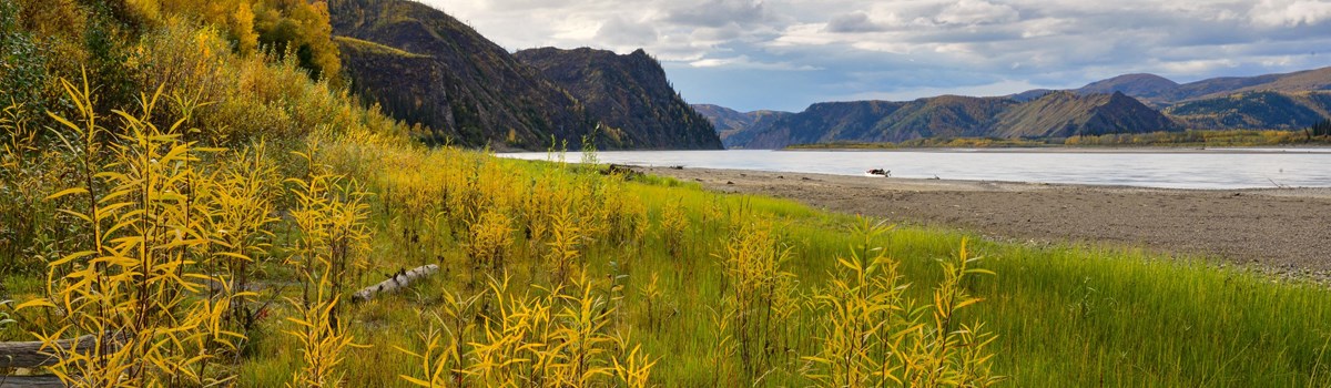
Timeless Rivers of Interior Alaska
Deep in Interior Alaska the great Yukon River strikes through bluffs and mountains of an ancient landscape to unmask rocks whose histories reach back a billion years to life's beginnings on Earth. Axis of the region, the silt-laden Yukon here flows constricted and swift through a great geologic fault. Side-streams tumble from the hinterlands—further passageways long inviting human traffic. Chief among these crystal rivers are the Charley, Kandik, and Nation. Flowing first through upland valley, then through stream-cut valley, and finally onto mature floodplain, the Charley River offers spectacular unspoiled wilderness scenery.
Arising at 4,000 feet of elevation, the Charley empties into the Yukon 700 feet above sea level, for an average gradient of 31 feet per mile and average current of four to six miles per hour. Side-streams have worn away old heights, softening the shapes of all but a few alpine peaks. The 2.5-million-acre Yukon-Charley Rivers National Preserve includes all 106 river miles of the Charley and encompasses its entire 1.1-million-acre watershed. Eons have passed here without catastrophic change. Today Yukon-Charley persists as a haven largely untouched by glaciation and mostly free of human imprint. Here are prime breeding grounds of the endangered peregrine falcon, calving grounds of the Fortymile caribou herd, choice paleontological sites, superb recreational waters, and the timeless presence of the mighty and historic Yukon River. The preserve lies between the communities of Eagle and Circle, Alaska. New Jersey with its 7.5 million residents would fit between these towns, but there are only 20 year-round residents here. Truly isolated, the preserve is wilder and less populated now than it was 50 or 80 years ago. The late-1800s Klondike and Nome gold rushes turned Circle—2000 population 100—into the Paris of the North, boasting an opera house. Pokes of gold were legal tender. This was the stuff of Jack London's stories and Robert Service's poetry. Eagle's population—about 130 in 2000—was 800. Fort Egbert had electric lights and hot-and-cold running water. Circle and Eagle were south-bank trade centers on the great Yukon River thoroughfare that bisects Alaska east to west for 1,250 river miles and stretches for 1,979 river miles from its headwaters near Whitehorse, in Canada's Yukon Territory, to its mouth at the Bering Sea. When not choked with stupendous, lethal spring and fall ice floes. the Yukon serves as summer waterway or frozen winter highway. Ancient hunters had traveled through the unglaciated Yukon corridor. Those who stayed probed the uplands for game via the stream-carved valleys. Forays upland took them first through thickets of willow and alder, through stands of white spruce and cottonwood screening the rivers, then across boggy flats punctuated by stunted black spruce. Mixed white spruce, birch, and aspen gave way to brush as the hunters climbed toward dry tundra on the ridges. Above them loomed always the barren mountains scored by scree slopes and topped by granite pinnacles.
What scientists think may be remnant Ice Age vegetation occurs as patches of arctic steppe on sun-drenched benches and bluffs. Now, winter's darkness and cold conspire to isolate this land abutting the Arctic Circle. Animals go to ground or migrate, or, like the mountain sheep, stand hunched against arctic winds. Rivers and streams freeze over. Deprived of silt from these frozen sources, the winter Yukon runs clear under as much as 6 feet of ice. But the sun returns. The rivers break. Bird calls herald spring. Peregrine falcons refurbish old cliff eyries, and the swift flight and stoop of these winged hunters take their toll on migrating birds. Salmon begin their runs, first the big kings and then the dog salmon. Here, 1,200 miles from the sea but with many miles left to swim, the powerful fish are still firm of flesh. And as they have for centuries, people gather at fish camps along the Yukon.
People who stayed after the glory days of gold faded—Han Indians already home and recent arrivals who had found a home—settled back into a slower pace, trapping, hunting, fishing, gardening. With easily exploited placer deposits of gold exhausted, mining, too, changed from a rush to long toil. Even today along the Yukon a fish camp may lie just around the bend—fishwheel or net in the water, fish drying on streamside racks. Hunters track moose and caribou, and trappers test their mettle against the unforgiving land. Life, in all its flintiness, persists here as it has for ages, and a few hardy souls still pit their fortunes against a true frontier wilderness.
Map Warning
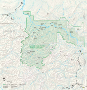 (click for larger map) |
Do not use this folder map for backpacking or navigation purposes. U.S. Geological Survey topographic maps for Eagle, Circle, Charley River, and Big Delta cover the national preserve at a scale of 1:250,000 and are available at preserve headquarters or by mail from the nonprofit Alaska Natural History Association at the park address (see More Information), this scale is the minimum practical for on-the-ground use. Maps at larger scales are available from U.S.G.S. outlets.
Note: Areas of private land exist within the preserve boundary. Respect private landowners' rights. Contact preserve headquarters for details on private land ownership.
Logistics
Scheduled air taxis serve Eagle and Circle all year. The Taylor and Steese highways, maintained gravel roads, connect Eagle and Circle with the Alcan Highway (161 miles) and Fairbanks (160 miles). Air taxis out of Fairbanks, Tok, and Circle Hot Springs make the Charley River easily accessible. There are several boat charter services that also provide transportation into the preserve along the Yukon River. (Please call the preserve for information on permitted air taxis and boat charters.)
Taylor Highway is usually closed by snow from October 15 to April 15. There are no roads, maintained trails, or maintained public airstrips in the national preserve. Most people boat or float via the Yukon River and its tributaries to reach the park.
Accommodations and services Several public-use cabins in the preserve are managed on a first-come, first-served basis, with no fees or reservations. The Coal Creek Dredge, Slaven's Roadhouse, and Coal Creek Mining Camp (restored) and airstrip are open to the public. In summer, Eagle and Circle offer food service; basic groceries and supplies, including gasoline; limited lodgings; campgrounds; public boat landings; and charter boat and air services. Near Circle, Central, and Circle Hot Springs there are lodgings, food service, stores, and gasoline. Authorized commercial guides provide hunting, camping, fishing, rafting, and kayaking guide services. Write to the preserve for a list.
Special note Local residents carry on subsistence activities in the preserve with camps, fishnets, and other equipment. Respect their property and privacy.
Weather
Extreme cold holds sway from late November to mid-March as temperatures sometimes plunge to -70°F. Snow accumulates except where winds scour the land. Breakup in mid-May and freezeup in mid-October may maroon travelers.
Summer brings extremes, too: freezing nights may follow daytime temperatures of 90°F. Thunderheads breed cloudbursts, and high winds produce squalls and whitecaps on the Yukon and wild fluctuations in water levels on smaller rivers. See Boating Safety for additional precautions.
Clothing, Food, and Gear
Self-sufficiency in all respects must be your guiding rule for wilderness travel here. Schedules will probably go awry because of weather or equipment failures in some remote place. Bring emergency food stocks—more than your scheduled time will require. If aircraft will pick you up at a remote location, prepare for being weathered in by bringing food for a couple of extra days.
Quality clothing (plenty of wool) that can be layered for changing conditions, sturdy camping and rain gear, and good insect repellent are essentials. Tents should have rain flies and insect netting and be designed to withstand strong winds.
What to See and Do
Deep Interior Alaska lies locked in ice, cold, and darkness most of the year. Winter visitors to Yukon-Charley must be expedition-equipped for survival. Yet when the rivers freeze and the black spruce bogs congeal, the land is open to cross-country travel. Returning light and moderating temperatures in March and early April invite experienced winter travelers to explore where human tracks are rare or absent.
Most visitors to the preserve float the Yukon or Charley rivers. The Charley is a premier clear-water float with fine scenery. The glacier-fed Yukon provides recreational opportunities for motorized and non-motorized watercraft of many sizes. Rafts and canoes, with or without motors, allow the greatest flexibility during the average 5- to 10-day float between Eagle and Circle. Floaters camp on open beaches and river bars, where winds keep down the insects.
Motorized boats may start from Circle and go upriver against the stiff Yukon current. A few people fly with bush pilots to the Charley headwaters or other tributary streams and float down to the Yukon and out of the area. Others line their boats up the sidestreams. Upland hiking is good in the mountainous regions. Exposed geological features, historic relics, expansive scenery, magnificent summer skyscapes, and, in less frequented canyons and uplands, the abundant wildlife fill your days with experiences to be treasured.
As a national preserve Yukon-Charley is open to both sport fishing and hunting under state and federal laws.
Eagle and Circle are historic places whose style of life and weathered buildings recall Athapascan Indian history, gold rush days, the riverboat era, and the frontier spirit. Eagle offers tours of its historic district and Fort Egbert in summer.
More information
Yukon-Charley Rivers National Preserve
P.O. Box 167
Eagle, AK 99738
www.nps.gov/yuch
Purchase maps from the Alaska Natural History Association, 750 W. Second Ave., Anchorage AK 99501.
Precautions
Harsh weather, high winds, and rain buffet the preserve. Guard against hypothermia. River water temperatures are cold and mid-channel spills can be lethal. Once you leave the well-traveled Yukon River corridor in this vast country you are completely on your own. Boil drinking water at least one minute to prevent Giardia problems. Know and test your gear before you arrive. You must possess good backcountry skills for wilderness survival.
Leave your itinerary with someone and notify that person when you complete your trip.
Bears and moose Respect all wild animals. Moose and bears, especially, should always be considered dangerous. Get and read a free bear pamphlet before you set out; write to the preserve address for a copy. This information about handling wildlife encounters could save your life. Be sure to keep food supplies separate from your campsite and equipment and make noise while hiking so that you do not startle bears or moose.
Winter travel is recommended only to those experienced in cold weather camping and survival techniques.
Boating Safety
Novice boaters have no business confronting rapids and the hazards of sweepers—trees that have fallen into a stream and lodged perpendicular to its current—on these wilderness rivers. Know your boat or other watercraft and its operation before you launch. All federal and state boating regulations apply. Carry signal equipment and a personal survival kit, including temporary shelter, warm clothing, and extra food. File a float plan with a responsible person and notify that person when you complete your trip. River water temperatures are cold; mid-channel spills can be lethal. Head for shore if you have equipment problems or if the weather worsens. Do not overload your craft.
Source: NPS Brochure (2005)
|
Establishment
Yukon-Charley Rivers National Preserve — December 2, 1980 |
For More Information Please Visit The  OFFICIAL NPS WEBSITE |
Documents
A History of National Park Service Clean-up Efforts at the Historic Coal Creek Mining District, Yukon-Charley Rivers National Preserve NPS Natural Resource Report NPS/YUCH/NRR-2015/1099 (Chris Allan, December 2015)
A Re-evaluation of Triassic Invertebrate Type Specimens of Craton-Bound Strata from the Lower Part of the Glenn Shale, Yukon-Charley Rivers National Preserve, East-Central Alaska (Robert B. Blodgett, Vincent L. Santucci, Howard R. Feldman and Valeryi V. Baranov, extract from Fossil Record 9, New Mexico Museum of Natural History and Science Bulletin, Vol. 94, 2023)
A River's Many Faces: Depictions of Life on the Yukon River by Charles O. Farciot and Willis E. Everette, 1882-1885, Yukon-Charley Rivers National Preserve Eyewitness Series No. 5 (Chris Allan, 2021)
Aerial Dall Sheep Survey, Yukon-Charley Rivers National Preserve, Alaska: July 2009 Survey Report NPS Natural Resource Technical Report NPS/CAKN/NRTR-2010/367 (John Burch, August 2010)
Aerial Moose Survey in Yukon-Charley Rivers National Preserve, November 2015 NPS Natural Resource Report NPS/YUCH/NRR—2016/1150 (Mathew S. Sorum and Kyle Joly, March 2016)
Aerial Survey of Dall's Sheep, Yukon-Charley Rivers National Preserve NPS Natural Resource Report NPS/YUCH/NRR-2015/1020 (Kyle Joy, September 2015)
American Peregrine Falcon (Falco peregrinus anatum) Monitoring along the Upper Yukon River in Yukon-Charley Rivers National Preserve, Central Alaska NetworkL 2007 NPS Natural Resource Report NPS/CAKN/NRTR—2008/079 (Melanie J. Flamme, John Burch, Robert (Skip) E. Ambrose, Chris Florian and Nikki Guldager, November 2007)
American Peregrine Falcon (Falco peregrinus anatum) Monitoring along the Upper Yukon River in Yukon-Charley Rivers National Preserve, Central Alaska Network: 2008 Report NPS Natural Resource Report NPS/CAKN/NRTR-2008/138 (Robert (Skip) E. Ambrose, Chris Florian, John Burch and Melanie Flamme, November 2008)
An Overview and Assessment of Prehistoric Archaeological Resources within Yukon-Charley Rivers National Preserve, Alaska NPS Research/Resources Management Report AR-15 (Kristen P. Griffen and E. Richard Chesmore, November 1988)
Annual Climate Monitoring Report for Denali National Park and Preserve, Wrangell-St-Elias National Park and Preserve and Yukon-Charley Rivers National Preserve (Pamela J. Sousanes, 2005)
Annual Report on Vital Signs Monitoring of Moose (Alces alces) Distribution and Abundance in Yukon-Charley Rivers National Preserve, Central Alaska Network: November 2012 Survey Report NPS Natural Resource Technical Report NPS/CAKN/NRTR-2012/772 (John Burch, July 2013)
Annual Report on Vital Signs Monitoring Of Wolf (Canis lupus) Distribution and Abundance in Yukon-Charley Rivers National Preserve, Central Alaska Network: 2008 Report NPS Natural Resource Technical Report NPS/CAKN/NRTR-2008/149 (John Burch, August 2008)
Annual Report on Vital Signs Monitoring Of Wolf (Canis lupus) Distribution and Abundance in Yukon-Charley Rivers National Preserve, Central Alaska Network: 2009 Report NPS Natural Resource Technical Report NPS/CAKN/NRTR-2009/228 (John Burch, July 2009 updated June 2010)
Annual Report on Vital Signs Monitoring of Wolf (Canis lupus) Distribution and Abundance in Yukon-Charley Rivers National Preserve, Central Alaska Network: 2010 Report NPS Natural Resource Technical Report NPS/CAKN/NRTR-2011/468 (John Burch, June 2011)
Annual Report on Vital Signs Monitoring of Wolf (Canis lupus) Distribution and Abundance in Yukon-Charley Rivers National Preserve, Central Alaska Network: 2011 Report NPS Natural Resource Technical Report NPS/CAKN/NRTR-2011/485 (John Burch, September 2011)
Annual Report on Vital Signs Monitoring of Wolf (Canis lupus) Distribution and Abundance in Yukon-Charley Rivers National Preserve, Central Alaska Network: 2012 Report NPS Natural Resource Technical Report NPS/CAKN/NRTR-2012/736 (John Burch, May 2013)
Annual Reports: 2003 • 2005 • 2006 • 2007 • 2008 • 2009 • 2010 • 2011 • 2012
Burning for Yukon Gold: The Hidden World of Underground Placer Mining in Alaska and the Klondike, 1898-1901, Yukon-Charley Rivers National Preserve (Chris Allan, ed., 2022)
Cultural Landscapes Inventory: Coal Creek Historic Mining District (2002)
Determination of Eligibility: Civil Aeronautics Administration Quarters (Chris Allan, 2023)
Determination of Eligibility: Coal Creek Open-Cut Mining Landscape, 1965-1985 (Chris Allan, January 27, 2025)
Eagle Development Concept Plan & Environmental Assessment, Yukon-Charley Rivers National Preserve, Alaska (July 1994)
Environmental Impact Statement: Cumulative Impacts of Mining, Yukon-Charley Rivers National Preserve, Alaska Draft (1989)
Environmental Overview and Analysis of Mining Effects, Yukon-Charley Rivers National Preserve, Alaska (July 1982)
Foundation Statement, Yukon-Charley Rivers National Preserve, Alaska (July 2012)
Foundation Document Overview, Yukon-Charley Rivers National Preserve, Alaska (January 2017)
Geologic Map of Yukon-Charley Rivers National Preserve, Alaska (December 2023)
Geologic Resources Inventory Report: Yukon-Charley Rivers National Preserve NPS Natural Resource Report NPS/NRSS/GRD/NRR-2023/2600 (Amanda Lanik, November 2023)
Gold, Steel & Ice: A History of Mining Machines in Yukon-Charley Rivers National Preserve (Chris Allan, 2015)
Golden Places: The History of Alaska-Yukon Mining (William R. Hunt, 1990)
Historic Structure Report: Coal Creek Camp, Yukon-Charley Rivers National Preserve, Alaska (Hennebery Eddy Architects and KPFF, April 2022)
Historic Structure Report: Flank Slaven's Roadhouse, Coal Creek, Yukon-Charley Rivers National Preserve, Alaska (Steven N. Peterson and Linda A. Cook, March 1990)
Historic Structure Report Update: Slaven's Roadhouse, Yukon-Charley Rivers National Preserve, Alaska (Hennebery Eddy Architects, April 2022)
In the Shadow of Eagle Bluff: A Pictorial History of the U.S. Army's Fort Egbert at Eagle, Alaska, 1899-1902 (Chris Allan, ed., 2021)
Invasive and Exotic Species Management for Yukon-Charley Rivers National Preserve: 2010 Summary Report NPS Natural Resource Data Series NPS/YUCH/NRDS-2010/103 (Chelsy Passmore and M. Susan Sherman, November 2010)
Invasive Plant Management in Yukon-Charley Rivers National Preserve and Gates of the Arctic National Park & Preserve: 2011 Summary Report NPS Natural Resource Data Series NPS/YUGA//NRDS-2012/228 (Matt Schultheis, January 2012)
Investigation of an Oil Shale Fire at Windfall Mountain: An Initial Assessment of an In-Situ Formation Fire NPS Natural Resource Data Series NPS/YUCH/NRDS-2014/733 (Linda Stromquist, November 2014)
Long-Range Interpretative Plan, Yukon-Charley Rivers National Preserve (May 2001)
Managing Historic Mining Artifacts on the Landscape (Anne Worthington, Logan Hovis, Abby Sue fisher, George Teague and Doug Beckstead, March 2002)
Middle Holocene Alluvial History of the Frank Slaven Roadhouse Site (CHR-0030), Yukon-Charley Rivers National Preserve, Alaska (Ian Buvit, Jillian Richie and Steven Hackenberger, June 2015)
Moose (Alces alces) population survey in Yukon-Charley Rivers National Preserve, November 2015 NPS Natural Resource Report NPS/YUCH/NRR-2016/1150 (Matthew S. Sorum and Kyle Joy, March 2016)
Moose (Alces alces) population survey in Yukon-Charley Rivers National Preserve, November 2019 NPS Natural Resource Report NPS/YUCH/NRR-2020/2127 (Matthew S. Cameron and Dylan T. Schertz, May 2020)
National Register of Historic Places Nomination Forms
Coal Creek Historic Mining District (Roderick Johnson and Ann Bischoff Kain, December 8, 1994)
Ed Biederman Fish Camp (undated)
Frank Slaven Roadhouse (undated)
George McGregor Cabin (undated)
Woodchopper Roadhouse (undated)
Yukon River Lifeways (Alison K. Hoagland and Sandra M. Faulkner, March 30, 1987)
Natural Resource Condition Assessment, Yukon-Charley Rivers National Preserve NPS Natural Resource Report NPS/YUCH/NRR-2012/527 (Kevin Stark, Kathy Kilkus, Eric Norton, Andy Nadeau, Lindsey Danielson, Shannon Amberg and Eric Iverson, June 2012)
Of Gold and Gravel: A Pictorial History of Mining Operations at Coal Creek and Woodchopper Creek, 1934-1938, Yukon-Charley Rivers National Preserve Eyewitness Series No. 4 (Chris Allan, 2021)
Orthorectification of Historic Imagery for Yukon Charley Rivers National Preserve NPS Natural Resource Report NPS/CAKN/NRTR-2014 (Andrew Robertson, Jeffrey Knopf, David Johnson, Bonnie Mafitt and Kyle Good, February 2014)
Plant associations and post-fire vegetation succession in Yukon-Charley Rivers National Preserve Natural Resource Technical Report. NPS/YUCH/NRTR—2005/001 (K.W. Boggs and M. Sturdy, 2005)
Soil Survey of Yukon-Charley Rivers National Preserve Area, Alaska (Nathan Parry, November 2013)
State of the Park Report, Yukon-Charley Rivers National Preserve, Alaska State of the Park Series No. 48 (2017)
The American Side of the Line: Eagle City's Origins as an Alaska Gold Rush Town As Seen in Newspapers and Letters, 1897-1899 (Chris Allan, ed., 2019)
The World Turned Upside Down: A History of Mining on Coal Creek and Woodchopper Creek, Yukon-Charley Rivers National Preserve (HTML edition) (Douglas Beckstead, 2003)
Upper Triassic Fossil Fauna from Craton-bound Strata of the Eastern Part of the Yukon-Charley Rivers National Preserve, East-Central Alaska (Robert B. Blodgett, Vincent L. Santucci, Jeffrey T. Rasic and Justin S. Tweet, extract from Alaska Geology: Newletter of the Alaska Geological Society, Vol. 53 No. 5, January 2023)
White Sweet Clover Reconnaissance, Summery Trip Report: Yukon-Charley Rivers National Preserve (Danielle Knapp, August 2020)
Wolf Monitoring Protocol for Denali National Park and Preserve, Yukon-Charley Rivers National Preserve and Wrangell-St. Elias National Park and Preserve NPS Natural Resource NPS/CAKN/NRR-2009/168 (Thomas J. Meier and John W. Burch, December 2004 revised August 2009)
Yukon Frontiers: Historic Resource Study of the Proposed Yukon-Charley National River (HTML edition) Occasional Paper No. 8 (Melody Webb Grauman, November 1977)
yuch/index.htm
Last Updated: 18-Mar-2025