|
John Day Fossil Beds National Monument Oregon |
|
 NPS photo | |
Fossil: Evidence of Past Life Preserved by Geologic Processes
Within the hills and valleys of eastern Oregon is one of the richest fossil beds on Earth, an ancient record spanning most of the Age of Mammals. Though the fossil organisms are long gone, their descendants may be living in our own backyards.
Named for the nearby river, the John Day Fossil Beds expose extraordinarily well preserved specimens. Also remarkable is the great number and variety of fossils: entire communities have been uncovered. There are remnants of past soils, rivers, ponds, mudslides, ashfalls, trackways, middens, prairies, and forests. This record occurs in an ordered sequence well interspersed with datable rock layers.
Science is ongoing here, and the discoveries do more than add to the list of fossils. They uncover an amazing array of evolutionary events: global and local changes in the distant past, climate fluctuations, extinctions, and life forms new to science. The John Day Fossil Beds reveal clues to our past and a glimpse of what our future could hold.
In Search of Lost Worlds
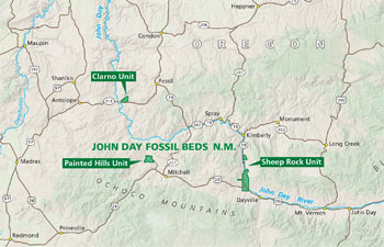 (click for larger map) |
Eastern Oregon was first recognized as an important paleontological region in the 1860s, thanks to the young frontier minister, Thomas Condon. Paleontology, the study of ancient life, was still a new science at the time. Condon's discoveries spurred scientific interest. By the late 1800s, scientists from Yale, Princeton, and the Smithsonian Institution had acquired tons of fossil specimens from the area, which they classified and presented to the scientific community.
This early work set the stage for field paleontologists like John C. Merriam of the University of California, who in 1899 began placing the John Day fossils into their geological, chronological, and paleoecological context. His work helped preserve these fossil resources. John Day Fossil Beds National Monument was established in 1975.
Exploration and study continue today. Each year hundreds of specimens are added to the collections. Most are mere fragments—a few teeth, for instance—but each is accompanied by a wealth of field data: geographical location, stratigraphic position, and other facts about its recovery. This information, as well as that gained as the fossils are prepared and studied in the lab, becomes part of the global paleontological record.
The John Day Fossil Beds are dispersed across 20,000 square miles of eastern Oregon. The beds have yielded such a wealth of information that scientists can assemble and reconstruct ancient ecosystems.
Eight of these "assemblages" are re-created in the museum gallery of the Thomas Condon Paleontology Center. They are summarized below.
Deep Time in the John Day Fossil Beds
      (click for larger maps) |
RATTLESNAKE ASSEMBLAGE
Scientists have found more fossils here of grazing animals than browsers. These animals lived in a relatively cool, semi-arid climate dominated by grasslands. Forests grew around lakes and rivers and at the higher elevations.
Many of these fossilized animals are very familiar to North America today: one-toed horses, pronghorn, beavers, ground squirrels, dogs, and true cats. Others, like elephants, rhinos, camels, and ground sloths, seem out of place, though they flourished in t e Rattlesnake's prairie environment.
MASCALL FORMATION Sufficient rainfall and fertile soil fostered the growth of lush, nutritious grasses and mixed hardwood forests much like those found today from Illinois to Ohio. This savanna-like landscape had broad floodplains with scattered lakes.
The grass and forest environment was home to swift, long-legged, hoofed animals like early grazing horses and camels that more resemble their modern relatives. The Mascall environment also attracted new-comers: true cats crossed over from Asia, along with four-tusked elephants called gomphotheres.
As forests receded and competitors changed, some groups like oreodonts headed toward extinction.
HAYSTACK VALLEY ASSEMBLAGE
Similar to the Mascall, this timespan featured cottonwood trees, alders, shrubs, and shallow rivers. These trees and leafy plants fed rhinos and chalicotheres—large, clawed creatures related to horses, tapirs, and rhinos. They were joined by open habitat species like camels and horses, more suited to the developing grasslands.
Daphoenodon, a beardog the size of a wolf, was a common predator. Bear-dogs are extinct today.
KIMBERLY ASSEMBLAGE
Geologic evidence suggests that large amounts of soft, ashy soils laid down during the Kimberly time allowed tiny burrowing animals to be fossilized. The number and variety of burrowing rodent fossils reflect more open habitat.
The habitat was forest and field, with elm, birch, oak, maple, fir, spruce, pine, and smaller plants and shrubs. Grasses may have just started to appear in the region. A very diverse population of oreodonts browsed the forests and fields along with three-toed horses and rhinos.
TURTLE COVE ASSEMBLAGE
During the Turtle Cove time, the climate continued to cool and dry. Hardwood forests similar to those growing in the eastern United States today were inundated with ash and pumice from abundant volcanic eruptions. The habitat was primarily woodland. Three-toed horses, mouse-deer, burrowing beavers, and oreodonts browsed on the many leafy plants.
Prey were hunted by dogs, bear-dogs, nimravids—saber-toothed, catlike animals of varied sizes—and entelodonts, creatures that looked like giant pigs and were as tall as bison.
BRIDGE CREEK FLORA
The Bridge Creek Flora shows evidence of one of Earth's cooling trends. As the region gradually became cooler and drier, it had forests, lakes, and swamps that resembled the parts of the southeastern United States.
Many trees in this ancient forest are related to modern alders, elms, maples, and oaks. The deciduous conifer Metasequoia, or dawn redwood, was widespread. Metasequoia is Oregon's state fossil.
The Bridge Creek Flora has fossils of leaves, fish, amphibians, birds, and insects preserved like pressed flowers in a book. Mammal fossils, like a rare bat, are unusual in these ashy lakebed sediments.
HANCOCK MAMMAL QUARRY
Picture the scene of a warm, humid forest; the plants are vaguely familiar. A scalding volcanic mudflow (lahar) has recently torn through the jungle-like foliage. Dozens of beasts gather in the newly opened area, the mud littered with plant and animal remains.
Mammals include Haplohippus, a small four-toed horse, huge rhino-like animals called brontotheres, an early rhino Teletaceras, and Plesiocolipirus, an early tapir.z
A variety of animal remains was preserved at this site, which is probably a former bend in a stream with high sedimentation.
CLARNO NUT BEDS
This was a wet, lush, semitropical forest with many vines and creepers—similar to Panama's jungles today.
Over 300 plant species have been found here—175 species of fruits and nuts alone, including chestnuts, walnuts, bananas, and moonseeds. Early magnolias and palms were common. These plant fossils are more than just leaf impressions, evidenced by one of the most diverse collections of petrified wood found anywhere.
Browsing mammals, like early four-toed horses and brontotheres, inhabited the forest. The catlike creodont Patriofelis was a major predator.
Your Guide to John Day Fossil Beds
John Day Fossil Beds National Monument encompasses 14,000 acres in three separate units: Painted Hills, Sheep Rock, and Clarno. Driving routes between units pass by stunning scenery, colorful geological features, and abundant wildlife.
The best place to start your visit and to see fossils is the Thomas Condon Paleontology Center, the park visitor center. It is open daily year-round; in winter it is closed on federal holidays.
Trails and picnic facilities are open year-round. Drinking water is available year-round at the paleontology center, and from Memorial Day to Labor Day at Cant Ranch, Painted Hills picnic area, and Clarno picnic area.
Camping, lodging, food, gas, RV parks, and other services are available near the park units. All park roads and parking areas allow bus and trailer access.
ACCESSIBILITY
We strive to make our
facilities, services, and programs accessible to all. For more
information, ask a ranger, check at the visitor center, or visit the
park website.
STAY SAFE, PROTECT THE PARK
Fossil
collecting is strictly prohibited. Researchers may collect fossils only
with a valid research permit issued by the park superintendent, and must
carry permit at all times. Federal law protects all fossils and
other natural and cultural features in the park. Do not collect, dig, or
disturb them in any way.
When hiking, please stay on trails and wear appropriate footwear and sun protection. Carry plenty of water. • Watch out for rattlesnakes, ticks, scorpions, black widow spiders, and puncture vine. Don't put your hands or feet where you cannot clearly see what's there.
Fishing requires a valid Oregon fishing license. • For firearms regulations, contact the park staff or visit the park website. • There is private property within the park boundary. Please respect posted warnings. • Pets must be on a 6-foot leash under the owner's control. Pets are allowed on park trails, overlooks, and roads. They are not allowed in buildings, off-trail, or off-leash.
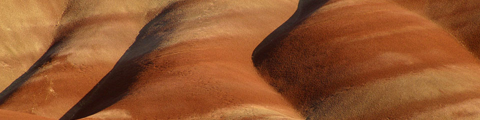
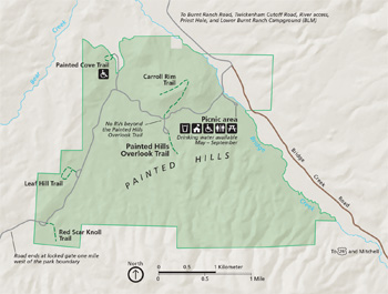
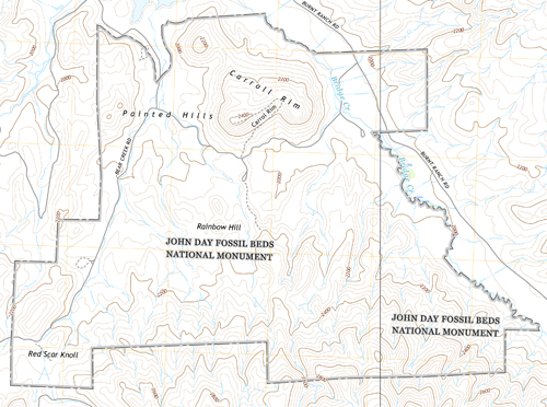
PAINTED HILLS UNIT
Painted Hills Unit, 9 miles northwest of Mitchell, OR, off US 26, has restrooms, water (summer only), shaded picnic tables, exhibits, and trails. Roads in the unit are dirt and gravel.
Painted Hills Overlook and Trail Best seen in the hours before sunset. Take in spectacular views of color-splashed hills, part of the lower John Day Formation. The short, 0.5-mile trail is one of the park's most picturesque.
Carroll Rim Trail A moderate climb, this 1.5-mile trail leads to an outstanding overview of the Painted Hills landscape and Sutton Mountain to the east.
Leaf Hill Trail is a 0.25-mile loop around a hill where thousands of fossils have been excavated, giving us our first glimpse of the Bridge Creek Flora. Hiking and collecting fossils on Leaf Hill itself are strictly prohibited.
Painted Cove Trail This short, 0.25-mile trail winds through yellow, crimson, and lavender hills, giving you a close view of the popcorn-textured claystones that distinguish the Painted Hills. Part of the trail is accessible by boardwalk.
Red Scar Knoll Trail This short, 0.25-mile trail ends at a strikingly bisected hill of tan and red claystone.
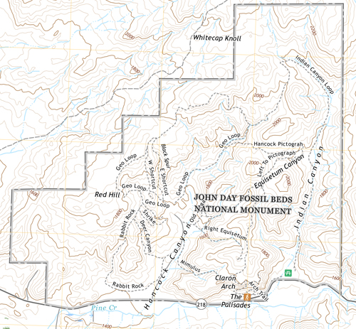
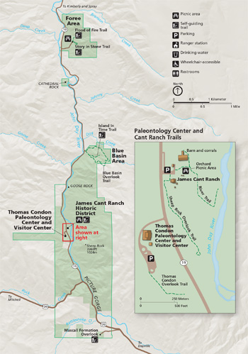
SHEEP ROCK UNIT
Sheep Rock Unit is at the intersection of OR 19 and US 26. The trails and overlook offer interpretive exhibits and restrooms.
Foree Area A picnic site and two short trails, each under 0.5 mile, offer views of sculpted green claystone capped by volcanic flows.
Cathedral Rock This roadside stop highlights a colorful greenish outcrop of the John Day Formation, capped with reddish ignimbrite.
Blue Basin The Island In Time Trail, an easy 1.3-mile walk, leads you into colorful banded badlands layers deposited 28-31 million years ago. The 3.25-mile Overlook Trail climbs high to the rim of the basin and rewards you with valley vistas. Off-trail hiking in Blue Basin is strictly prohibited.
Goose Rock These cliffs are made up of material that flowed into the ocean about 90 million years ago.
Picture Gorge These imposing lava layers are part of the Picture Gorge Basalt, a subgroup of the Columbia River flood basalt group spread over the Pacific Northwest.
Mascall Formation Overlook The view from this point takes in the upper John Day Valley, Strawberry Mountain Range, Picture Gorge, and the Mascall and Rattlesnake formations.
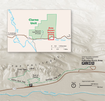
CLARNO UNIT
Clarno Unit is 18 miles west of Fossil, OR, off OR 218. There is a picnic area and restrooms. This unit also has two significant fossil sites not open to the public: Clarno Nut Beds and Hancock Mammal Quarry
Trails Three short trails with interpretive displays let you explore the towering Palisades. These craggy cliffs looming up to 150 feet over the valley were formed when a succession of ash-laden mudflows (lahars) swept through a forested landscape 45 million years ago. A jumble of fossils is embedded in the rocks.
The 0.25-mile Trail of the Fossils allows you to see actual fossils embedded in rock. The Clarno Arch Trail is a 0.5-mile climb to a natural arch in The Palisades.
Hancock Field Station Operated by the Oregon Museum of Science and Industry, this camp offers educational programs on geology, paleontology, and ecology. Please visit by appointment only. For additional information, visit www.omsi.edu.
THOMAS CONDON PALEONTOLOGY CENTER
Located in the Sheep Rock Unit, the Thomas Condon Paleontology Center is a National Park Service research facility dedicated to the John Day Fossil Beds. It is also the park visitor center and fossil museum. Picture windows let you view the working laboratory and collections room with over 60,000 specimens.
In the fossil museum gallery, you can walk through nearly 50 million years of the Age of Mammals. Hundreds of fossil specimens are displayed, along with eight large murals depicting plants and animals of the time. Each display explains the geology then and now.
JAMES CANT RANCH
The dry hills of eastern Oregon provided ideal grazing land for livestock, mainly sheep and cattle. James and Elizabeth Cant, Scottish immigrants, bought this land in the early 1900s. The Cant family operated the ranch until the National Park Service purchased it in the 1970s.
The 1917 ranch house has been renovated to host park headquarters and a museum telling the human story of the area, from the first native inhabitants through to the sheep and cattle ranchers of the 20th century. The 0.6-mile River Trail passes by the barn and historic orchard. The 0.5-mile Sheep Rock Overlook Trail offers views of the John Day River.
Source: NPS Brochure (2018)
|
Establishment John Day Fossil Beds National Monument — October 26, 1974 |
For More Information Please Visit The  OFFICIAL NPS WEBSITE |
Documents
2003 Study of Bat Roosts, John Day Fossil Beds National Monument (Thomas J. Rodhouse and R. Gerald Wright, September 1, 2004)
A Framework for Ecologically-based Invasive Plant Management: John Day Fossil Beds National Monument NPS Natural Resource Report NPS/UCBN/NRR—2015/911 (Shirley Hoh, Thomas J. Rodhouse, Dan Esposito, Roger Sheley and Brenda Smith, February 2015)
A Landscape of Memory, Uncovered (John F. Fiedor, c2000)
A mafic dike system in the vicinity of Mitchell, Oregon, and its bearing on the timing of the Clarno-John Day volcanism and early Oligocene deformation in central Oregon (Edward M. Taylor, extract from Oregon Geology, Vol. 43 No. 8, August 1981)
A Report to the National Park Service on the Significance, History of Investigation, and Salient Paleontological Features of the Upper John Day Basin, Wheeler and Grant Counties, Oregon (HTML edition) (J. Arnold Shotwell, 1976)
A Socioeconomic Atlas for John Day Fossil Beds National Monument and its Region (Jean E. McKendry, Cynthia A. Brewer and Joel M. Staub, 2004)
A Survey of Butterflies of the John Day Fossil Beds National Monument (Sue Anderson, 2004)
Accessibility Self-Evaluation and Transition Plan Overview, John Day Fossil Beds National Monument, Oregon (September 2018)
Acoustical Monitoring Report 2014: John Day Fossil Beds National Monument NPS Natural Resource Report NPS/JODA/NRR—2014/976 (Ashley R. Pipkin, June 2015)
Age of the plant-bearing tuffs of the John Day Formation at Fossil, Oregon, based upon 40Ar/39Ar single-crystal dating (William C. McIntosh, Steven R. Manchester and Herbert W. Meyer, extract from Oregon Geology, Vol. 59 No. 1, January/February 1997)
Ancient Life and Landscapes (2000)
Cant Ranch Historic District, Cultural Landscapes Inventory (2009)
Clarno Nut Beds (undated)
Clinoptilolite Tuff from the John Day Formation, Eastern Oregon (Richard V. Fisher, extract from The Ore Bin, Vol. 24 No. 12, December 1962)
Common Fossils, Wheeler High School Fossil Beds, Bridge Creek Member, John Day Formation (Date Unknown)
Coyotes and Mule Deer of John Day Fossil Beds National Monument: A Management Report (HTML edition) Cooperative Studies Unit Report 80-2 (Brad Griffith, 1980)
Cultural Landscape Report: Cant Ranch Historic District (Terri Taylor and Cathy Gilbert, September 1996)
Cultural Landscapes Inventory: Cant Ranch Historic District (2009)
Distribution and Status of Endemic and Non-Native Plant Species at the Painted Hills Unit of John Day Fossil Beds National Monument (Arne Buechling, December 2008)
Distribution, Foraging Behavior, and Capture Results of the Spotted Bat (Euderma maculatum) in Central Oregon (Thomas J. Rodhouse, Maureen F. McCaffrey and R. Gerald Wright, extract from Western North American Naturalist, Vol. 65 No. 2, 2005)
Draft General Management Plan/Environmental Assessment, John Day Fossil Beds National Monument (July 2008)
Early Oligocene paleoenvironment of a paleosol from the lower part of the John Day Formation near Clarno, Oregon (Aberra Getahun and Gregory J. Retallack, extract from Oregon Geology, Vol. 53 No. 6, November 1991)
Enabling Legislation (1974, 1978)
First mesonychid from the Clarno Formation (Eocene) of Oregon, USA (Selina V. Robson, Nicholas A. Famoso, Edward Byrd Davis and Samantha S.B. Hopkins, extract from Palaeontologia Electronica, Vol. 22, 2019)
Floating in the Stream of Time: An Administrative History of John Day Fossil Beds National Monument (HTML edition) (Stephen R. Mark, 1996)
Fossil Flora of the John Day Basin Oregon (HTML edition) USGS Bulletin 204 (Frank Hall Knowlton, 1902)
Fossil plants of the Eocene Clarno Nut Beds (Steven R. Manchester, extract from Oregon Geology, Vol. 43 No. 6, June 1981)
Fossil Species List (partial) (2000)
Foundation Document, John Day Fossil Beds National Monument, Oregon (March 2017)
Foundation Document Overview, John Day Fossil Beds National Monument, Oregon (January 2017)
Freshwater Fish Remains from the Clarno Formation, Ochoco Mountains of North-Central Oregon (Ted M. Cavender, extract from The Ore Bin, Vol. 30 No. 7, July 1968)
General Management Plan, John Day Fossil Beds National Monument, Oregon (October 1979)
General Management Plan, John Day Fossil Beds National Monument (May 2009)
Geochronology of the Clarno Igneous Activity in the Mitchell Quadrangle, Wheeler County, Oregon (Harold E. Enlows and Donald J. Parker, extract from The Ore Bin, Vol. 34 No. 6, June 1972)
Geologic framework of the Clarno Unit, John Day Fossil Beds National Monument, Central Oregon (E.A. Bestland, P.E. Hammond, D.L.S Blackwell, M.A. Kays, G.J. Retallack, and J. Stimac, Oregon Geology, Vol. 61 No. 1, January/February 1999; courtesy of Oregon Department of Geology and Mineral Industries)
Geologic, Paleontologic, and Contemporary Introduction to John Day Fossil Beds National Monument (undated)
Geologic Reconnaissance of the Antelope-Ashwood Area, North-Central Oregon USGS Bulletin 1161-D (Dallas L. Peck, 1964)
Geologic Resources Inventory Report, John Day Fossil Beds National Monument NPS Natural Resource Report NPS/NRPC/GRD/NRR-2014/846 (J.P. Graham, August 2014)
Geology and Paleoenvironments of the Clarno Unit: John Day Fossil Beds National Monument (Erik A. Bestland and Gregory J. Retallack, June 28, 1994)
Geology of the John Day Country, Oregon (Margaret L. Steere, extract from The Ore Bin, Vol. 16 No. 7, July 1954)
Geology Road Log (Painted Hills to Sheep Rock Visitor Center) (undated)
Guide to some Volcanic Terranes in Washington, Idaho, Oregon, and Northern California USGS Circular 838 (David A. Johnston and Julie Donnelly-Nolan, 1981)
Impacts of Visitor Spending on the Local Economy: John Day Fossil Beds National Monument, 2004 (Daniel J. Stynes, June 2006)
Indians of Eastern Oregon (HTML edition) (Kathyrn Lee, 1977)
John Day Fossil Beds: A Study (Preliminary) (HTML edition) (1967)
John Day River Wild and Scenic River Study (Final, September 1979)
Junior and Senior Ranger — Discovering John Day Fossil Beds, John Day Fossil Beds National Monument (Date Unknown; for reference purposes only)
Land Protection Plan, John Day Fossil Beds National Monument, Oregon (February 1984)
Late Eocene fossil plants of the John Day Formation, Wheeler County, Oregon (Steven R. Manchester, extract from Oregon Geology, Vol. 62 No. 3, July 2000
Long-Range Interpretive Plan, John Day Fossil Beds National Monument (March 2010)
Major Turtle Cove Member (John Day Formation) (2000)
Map: Sutton Complex - Painted Hills National Monument Proposal (October 27, 2021)
Mercury and uranium mineralization in the Clarno and John Day Formations, Bear Creek Butte area, Crook County, Oregon (R. Matthew Wilkening and Michael L. Cummings, extract from Oregon Geology, Vol. 49 No. 9, September 1987)
Microtomography of an enigmatic fossil egg clutch from the Oligocene John Day Formation, Oregon, USA, reveals an exquisitely preserved 29-million-year-old fossil grasshopper ootheca (Jaemin Lee, Nicholas A. Famoso and Angela Lin, extract from Park Stewardship Forum, Vol. 40 No. 1, 2024)
Monitoring Sagebrush-steppe Vegetation in the UCBN: October 2008 • October 2009 • October 2010
Monitoring Sagebrush-steppe Vegetation in the Upper Columbia Basin Network, 2008 Annual Monitoring Report, City of Rocks National Reserve, Hagerman Fossil Beds National Monument, John Day Fossil Beds National Monument NPS Natural Resource Technical Report NPS/UCBN/NRTR-2009/182 (Thomas J. Rodhouse, March 2009)
Museum Management Plan, John Day Fossil Beds National Monument (Carola DeRooy, Greg McDonald, Steve Floray, Herbert W. Meyer, Ted Fremd, Diane L. Nicholson and Sally Shelton, 2008)
National Register of Historic Places Nomination Form
James Cant Ranch Historic District (Stephanie Toothman, 1983)
Natural Resource Condition Assessment, John Day Fossil Beds National Monument NPS Natural Resource Report NPS/UCBN/NRR-2010/174 (Jack Bell and Dustin Hinson, January 2010)
Novel analysis of locality data can inform better inventory and monitoring practices for paleontological resources at John Day Fossil Beds National Monument Oregon, USA (Anne E. Kort and Nicholas A. Famoso, extract from Paleontologica Electronica, Vol. 23 No. 1, 2020)
Oligocene fossil plants of the John Day Formation, Fossil, Oregon (Steven R. Manchester and Herbert W. Meyer, extract from Oregon Geology, Vol. 49 No. 10, October 1987)
Paleontological Resource Inventory and Monitoring, Upper Columbia Basin Network NPS TIC# D-259 (Jason P. Kenworthy, Vincent L. Santucci, Michaleen McNerny and Kathryn Snell, August 2005)
Plant Fossils in the Clarno Formation, Oregon (Herbert L. Hergert, extract from The Ore Bin, Vol. 23 No. 6, June 1961)
Preliminary assessment of the extent of the leaf fossil beds at Wheeler High School, Fossil, Wheeler County, Oregon (Mark L. Ferns, Jason D. McClaughry and Ian P. Madin, extract from Oregon Geology, Vol. 68, No. 1, Fall 2007)
Preliminary observations on fossil soils in the Clarno Formation (Eocene to early Oligocene) near Clarno, Oregon (Greg Retallack, extract from Oregon Geology, Vol. 43 No. 11, November 1981)
Preliminary Report on Fossil Fruit and Seeds from the Mammal Quarry of the Clarno Formation, Oregon (Thomas M. McKee, extract from The Ore Bin, Vol. 32 No. 7, July 1970)
Raptors of John Day Fossil Beds National Monument (HTML edition) Cooperative Studies Unit (Stewart Janes, 1977)
Reconstructions of Eocene and Oligocene Plants and Animals of Central Oregon (Gregory J. Retallack and Erick A. Bestland, Oregon Geology, Vol. 53 No. 3, May 1996; courtesy of Oregon Department of Geology and Mineral Industries)
Re-evaluating hypertragulid diversity in the John Day basin, Oregon, USA (Nicholas A. Famoso and Lana K. Jewell, extract from Acta Palaeontologica Polonica, Vol. 69 No. 3, 2024)
Revegetation With Native Plant Species on the John Day Fossil Beds National Monument CPSU/OSU 84-8 (R.F. Miller, M. Haferkamp, A. Evenden and B. Youtie, 1984)
Revegetation With Native Plant Species on the John Day Fossil Beds National Monument CPSU/OSU 88-9 (Marshall R. Haferkamp and Richard F. Miller, October 1, 1988)
Rocks & Hard Places: Historic Resources Study (HTML edition) (Stephen Dow Beckham and Florence K. Lentz, 2000)
Sagebrush Steppe Vegetation Monitoring in Craters of the Moon National Monument and Preserve, Hagerman Fossil Beds National Monument, John Day Fossil Beds National Monument, and Lake Roosevelt National Recreation Area: 2009 Annual Report NPS Natural Resource Technical Report NPS/UCBN/NRTR-2010/302 (Thomas J. Rodhouse, March 2010)
Sagebrush Steppe Vegetation Monitoring in John Day Fossil Beds National Monument, 2011 Annual Report NPS Natural Resource Report NPS/UCBN/NRDS-2012/226 (Jeffrey J. Yeo and Thomas J. Rodhouse, January 2012)
Sagebrush Steppe Vegetation Monitoring in John Day Fossil Beds National Monument, 2014 Annual Report NPS Natural Resource Report NPS/UCBN/NRDS-2015/797 (Dan M. Esposito and Thomas J. Rodhouse, May 2015)
Sagebrush Steppe Vegetation Monitoring in the Blue Basin Area of the John Day Fossil Beds National Monument, 2018 Annual Report NPS Natural Resource Report NPS/UCBN/NRR-2019/1868 (Melissa M. Nicolli, February 2019)
Sagebrush Steppe Vegetation Monitoring in the Clarno Unit of the John Day Fossil Beds National Monument, 2012 Annual Report NPS Natural Resource Report NPS/UCBN/NRDS-2012/396 (Kelly J. Smith, Alephair F. Bylund, Ellen Robson and Erik Maass, December 2017)
Sagebrush Steppe Vegetation Monitoring in the Clarno Unit of the John Day Fossil Beds National Monument, 2013 Annual Report NPS Natural Resource Report NPS/UCBN/NRDS-2013/546 (Thomas J. Rodhouse, September 2013)
Sagebrush Steppe Vegetation Monitoring in the Clarno Unit of the John Day Fossil Beds National Monument, 2017 Annual Report NPS Natural Resource Report NPS/UCBN/NRR-2017/1571 (Dan M. Esposito, Devin S. Stucki and Thomas J. Rodhouse, October 2012)
Sagebrush Steppe Vegetation Monitoring in the Blue Basin Area of the John Day Fossil Beds National Monument, 2018 Annual Report NPS Natural Resource Report NPS/UCBN/NRR-2019/1868 (Melissa M. Nicolli, February 2019)
State of the Park Report, John Day Fossil Beds National Monument, Oregon State of the Park Series No. 9 (December 2013)
Statement for Management — John Day Fossil Beds National Monument (Benjamin L. Ladd, 1992)
Structure and Orogenic History of the Southwestern Part of the John Day Uplift, Oregon (H.J. Buddenhagen, extract from The Ore Bin, Vol. 29 No. 7, July 1967)
Subduction-related origin of the volcanic rocks of the Eocene Clarno Formation near Cherry Creek, Oregon (Jeffrey B. Noblett, extract from Oregon Geology, Vol. 43 No. 7, July 1981)
Survey of Historic and Prehistoric Resources in the John Day Fossil Beds National Monument (Wilbur A. Davis, May 1977)
The Discovery of a New Fossil Tapir in Oregon (Wm. J. Sinclair, extract from The Journal of Geology, Vol. 9 No. 8, November-December 1901)
The first records of Sinclairella (Apatemyidae) from the Pacific Northwest, USA (Joshua X. Samuels, extract from PaleoBios, Vol. 38, 2021)
The Fossil Record / Paleonews
Vol. I No. I (undated)
Vol. I No. II (undated)
Primate Molar Emerges From Fossil Beds (Jennifer Chapman, 1998)
Prospecting at Sheep Rock (Jennifer Chapman, 1998)
"Terminator Pigs" of Eastern Oregon (Ted Fremd, 1999)
Entelodon Legacy (Tonia Seebart, 1999)
Return to Rhino Hill (Delda Findeisen, 1998)
Oregon Condor (Ted Fremd, 1996)
Galloping Over the Graves of Their Ancestors (Ted Fremd, 1998)
The Beast of Frank's Creek (Ted Fremd, 1998)
Twickenham (Ted Fremd, 1998)
Saber-toothed Salmon (Ted Fremd, c1998)
1997: Summer
1998: Spring
2011: Spring • Fall-Winter
2002: Spring
2003: Summer • Fall-Winter
2004: Summer-Fall
2005: Fall-Winter
The Geologic Setting of the John Day Country, Grant County, Oregon USGS Information Circular (Thomas P. Thayer, 1972)
The Geologic Setting of the John Day Country, Grant County, Oregon USGS Information Circular (Thomas P. Thayer, 1977)
The Geologic Setting of the John Day Country, Grant County, Oregon (HTML edition) USGS Information Circular (Thomas P. Thayer, 1972, reprint 1990)
The Geology and Mineral Resources of the John Day Region (Arthur J. Collier, Mineral Resources of Oregon, Vol. 1 No. 3, March 1914)
The Oligocene Bridge Creek Flora of the John Day Formation, Colorado University of California Publications in Geological Sciences Vol. 141 (Herbert W. Meyer and Steven R. Manchester, October 1997, ©The Regents of the University of California)
The Peoples of John Day: An Ethnographic and Ethnohistoric Overview of John Day Fossil Beds National Monument (Douglas Deur, Rochelle Bloom, Katie Wynia, Tricia Gates Brown, and the Traditionally Associated Tribes of John Day Fossil Beds, 2023)
Thomas Condon (Chester W. Washburne, extract from The Journal of Geology, Vol. 15 No. 3, April-May 1907)
Updated Biostratigraphy of the Turtle Cove Member (John Day Formation) in the John Day Basin, Oregon (Nicholas A. Famoso, Joshua X. Samuels, Samantha S.B. Hopkins, Meaghan M. Emery and Edward Byrd Davis, Date Unknown)
Water availability and flood hazards in the John Day Fossil Beds National Monument, Oregon USGS Open-File Report 79-1487 (Frank J. Frank and E.A. Oster, 1979)
Zeolite-Rich Beds of the John Day Formation, Grant and Wheeler Counties, Oregon (Richard V. Fisher, extract from The Ore Bin, Vol. 25 No. 11, November 1963)
Behind the Scenes of Fossil Discoveries Duration: 5:18 (Argentine Productions, April 21, 2020)
John Day Fossil Beds (NPS)
Layers of Life: Stories of Ancient Oregon Duration: 20:51 (Argentine Productions, April 21, 2020)
One Park, Three Units Duration: 2:02 (NPS, March 27, 2020)
Your Guide to Painted Hills Duration: 3:09 (NPS, May 16, 2020)
joda/index.htm
Last Updated: 01-Jan-2025