|
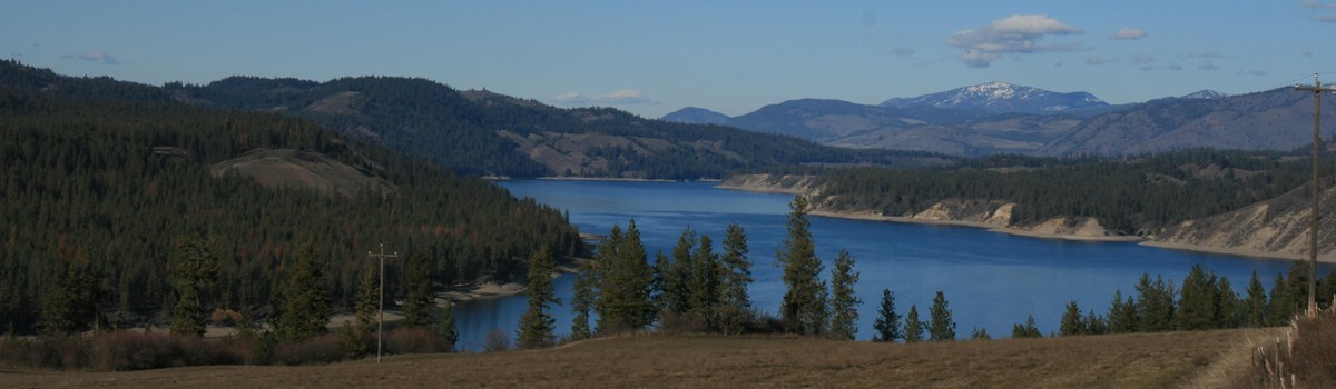
Lake Roosevelt National Recreation Area Washington |
|
 NPS photo | |
The river now becomes deeply encañoned.... the bluffs are many-colored.... To this must be added the green of the trees.... the old gold of the bunch-grass shining in the sunlight.... forming one of the grandest, most beautiful sights in the universe.
—Lt. Thomas W. Symons, Columbia River Navigation Survey, 1881
The Mighty Columbia...
For tens of thousands of years the Columbia River flowed wild and free. The untamed waters made their way to the Pacific—changing channels, skirting glaciers, suddenly flooding—controlled only by what nature dictated. Nomadic Indians moved with the seasons and followed their sources of food. Various Salishan tribes in the north whose lives centered around the Columbia River called it Swah-netk'-qhu—Big Water. Indians knew the river for its rich salmon runs. In the 1800s traders and settlers knew it as a transportation route that brought supplies upriver and delivered furs and crops downriver. In the mid-1900s the building of dams harnessed the river as never before. People now experienced the river in new ways. Dams provided electricity and irrigation water and protected homes from flooding. Construction of Grand Coulee Dam led to the creation of Lake Roosevelt, in 1946 the area was federally designated a national recreation area.
Today sagebrush and golden bunchgrass adorn the shores along the southern half of the lake. Lichens on basalt cliffs add splashes of yellow, red, and green. The northern half of the park reveals cooler mountains forested with ponderosa pine, Douglas fir, and western larch. As Lieutenant Symons did in 1881, you can marvel at the landscape—it is still a grand and most beautiful sight.
READING THE ROCKS
During the last ice age a massive glacial lobe moved down from Canada, creating an ice dam that blocked the natural courses of rivers. Rivers backed up. Huge lakes formed, including Lake Missoula. The increasing level of the water behind the ice dam caused it to float and burst. Sudden, massive walls of water—some thought to be 400 feet high with speeds approaching 65 miles per hour flushed across central Washington. This cycle, glaciers advancing and retreating, floods caused by ice dams forming and bursting, repeated many times. The water carried gravel and debris, icebergs and boulders, scouring bedrock into the bizarre landscape we call channeled scablands and gouging steep-walled gorges called coulees.
River of Life, River of Dreams
TRIBES AND RESERVATIONS
American Indians have lived here for over 9,000 years—fishing, hunting animals, and collecting wild fruits and vegetables. Each year tribes gathered at the river to catch salmon, trade goods and ideas, and socialize.
Life began to change in the early 1800s as vastly different cultures arrived—fur traders, missionaries, settlers, and soldiers. Encroachment on traditional native lands led to tensions between Indians and newcomers, culminating in a brief war, treaties, and the establishment of reservations. Eventually the Spokane and Colville tribes moved to land allotted along the Columbia. In the 1930s, with the building of dams, traditional fishing ended. The upper river was blocked to salmon; homes and sacred sites flooded. As a native explained, "The river we had known was destroyed.... The salmon came no more, and with the disappearance of the salmon, our traditional economy was lost forever." Today the Columbia is still alive, and Spokane and Colville elders tell stories of the river to their children.
KETTLE FALLS
Kettle Falls once was an annual gathering place for Indian tribes who came to fish. Here huge, angled slabs of rock straddled the river, forcing the water over a series of falls. The waterfalls produced a natural barrier for migrating salmon, making fish easier to catch. Indians speared and netted thousands of salmon—enough to provide half of their families' diet for the coming year.
In the early 1800s fur trappers came to trade, and missionaries came to baptize. The Hudson's Bay Company established Fort Colvile in 1825, a self-sufficient trading post with homes, farms, shops, and buildings for storing furs. The fort's location at Kettle Falls made it a prime spot for collecting and sending valuable pelts—beaver, bear, mink, lynx, and wolf—downstream for shipment east. Missionaries, like fur traders before them, had considerable impact on local tribes. Priests introduced a new religion, promoted farming and a sedentary life (over traditions of fishing, hunting, and gathering), and built churches, including St. Paul's Mission.
The falls and the site of Fort Colvile are now submerged, but the Indians still gather annually—praying for return of the salmon.
FORT SPOKANE
Fort Spokane, established in 1880, was one of the last frontier forts built in the West. Ownership of land became a problem as the area filled with entrepreneurs seeking the agricultural opportunities promoted by the Northern Pacific Railroad. Keeping the semi-nomadic Spokane and Colville tribes within reservation boundaries—and keeping land-hungry settlers out—was potentially a difficult job. The fort's strategic location at the confluence of the Columbia and Spokane rivers allowed a small peace-keeping force of infantry and cavalry troops to keep an eye on the Indians and the settlers. Fortunately this was a time of relative peace. The troops at Fort Spokane saw little action aside from routine drills, parades, and patrol duty.
In 1898 most troops left for duty in Cuba after the outbreak of the Spanish-American War. The post was decommissioned and transferred to the Bureau of Indian Affairs. The fort opened as an Indian boarding school in 1900, but declining enrollments closed the school in 1908. The fort served on and off as a tuberculosis sanatorium and Indian hospital until its final closure in 1929.
GRAND COULEE DAM
The decision to build Grand Coulee Dam was not made casually. For decades politicians, private companies, landowners, and the public argued about the dam's location, design, and purpose. Was it to provide hydroelectric power, irrigation, flood control? The election of Franklin Delano Roosevelt (FDR) in 1932 ended the debate. FDR was convinced that building large, public infrastructure projects would revive the economy and get people back to work. Roosevelt was especially interested in projects in the Columbia Basin.
The U.S. Bureau of Reclamation began construction in 1933. When completed in 1942 Grand Coulee Dam was the largest masonry structure ever built, breaking a record, set by Egypt's Great Pyramid, that stood for 47 centuries. Today the dam is the largest producer of hydroelectric power in the United States and third largest hydroelectric facility in the world. Grand Coulee provides electricity for hundreds of cities and supplies irrigation water for over 500,000 acres of cropland.
INDIANS
For centuries Indians fished in the river that carried life-sustaining salmon. Loss of fisheries above the dam changed their lives forever.
Then God put fish in the rivers.... When the Creator gave us Indians life, we awakened and as soon as we saw the fish and the game we knew that they were made for us.—Colville and Okanogan Chiefs, 1925
FUR TRADERS
Traders like Jaco Finlay ventured here in the early 1800s. Rivals Hudson's Bay Company and North West Company bartered with Indians for pelts in exchange for blankets, cloth, mirrors, tobacco, ammunition, and rifles. Traders exchanged a $6 rifle for 20 beaver skins, each worth $50. In 1832 a HBC employee wrote, "We made an enormous profit on the Indian trade."
DAVID THOMPSON
The first explorer to document his travels here was fur trader and mapmaker David Thompson in 1811. He had two motives: build trading posts and chart the Columbia from its headwaters to its mouth. (Lewis and Clark traveled the lower river in 1805.) Thompson's party reached Kettle Falls on June 19, in time to see Indians from many tribes harvesting salmon.
MISSIONARIES
In the mid-1830s missionaries began visiting the upper Columbia region, hoping to convert Indians to Christianity and improve their lives. In 1841 Father DeSmet spent 10 days at Fort Colvile (near Kettle Falls), preaching and baptizing. Father Ravalli built the first Indian chapel at Kettle Falls in 1845. Two years later St. Paul's Mission was built above the falls.
FORTUNE SEEKERS
Gold discovered near Kettle Falls! In 1854 a Hudson's Bay Company employee found gold on the sandbars of the upper Columbia. When the news leaked out a wave of fortune seekers flooded the region. Miners found relatively little gold, but their presence—as they rushed from one reported gold strike to the next—created demands for new businesses and settlements.
CHINESE
Chinese were the first Asians to arrive in eastern Washington in large numbers. By the mid-1860s hundreds of men worked placer mines along the Columbia, from China Bend to the river's mouth. By 1870 Chinese miners outnumbered American-born miners two-to-one. They built mining camps, laundries, and stores, providing services for nearby towns.
SETTLERS
In the 1870s settlers established permanent homes and businesses in the area. Some ran supply boats on the river, others farmed wheat or harvested and sold lumber. The completion of railroads in the 1880s brought a new influx of settlers. The railroads gave farmers and businesses a new way to get orchard crops, grains, and livestock to market.
SOLDIERS
The presence of troops at Fort Spokane in the 1880s pacified settlers moving into the area and helped keep peace among Indian tribes as they saw their traditional hunting, farming, and homelands shrink. At the height of U.S. Army occupation over 300 soldiers plus their families and other civilians lived at Fort Spokane.
FRANKLIN D. ROOSEVELT
Roosevelt (FDR) promised a New Deal for the American people during his presidential campaign. When FDR took office in 1933 he quickly launched programs to create jobs and bring the U.S. out of the Depression. The new Public Works Administration oversaw construction of housing, bridges, and dams, including Grand Coulee. Today the lake bears FDR's name.
DAM BUILDERS
During the peak of dam construction over 8,000 people worked in various jobs. Engineers and surveyors determined the exact placement of the dam and location of new roads and railroads. Laborers cleared trees from the reservoir area, excavated the dam site, built towns on each side of the river, rerouted the river temporarily, and poured tons of concrete.
PARK AND PARTNERS
The creation of Lake Roosevelt led to the establishment of the national recreation area in 1946. Today the lake, shoreline, and surrounding federal lands are managed by the National Park Service, Bureau of Reclamation, Bureau of Indian Affairs, Colville Confederated Tribes, and Spokane Tribe—five partners protecting resources of the lake.
PARK VISITORS
Water, cool water. Most visitors come to Lake Roosevelt for its refreshing water and its premier opportunities for boating, watersports, and fishing. But there is more here than the lake. You can camp, picnic, hike, visit historic Fort Spokane and St. Paul's Mission, and join ranger-led activities, offered seasonally.
Exploring Lake Roosevelt
Enjoying the Lake and Shore
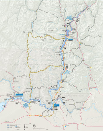 (click for larger map) |
Lake Roosevelt National Recreation Area stretches north 129 miles, from Grand Coulee Dam to Onion Creek, 13 miles from the U.S-Canadian border. It embraces the lower reaches of many streams, including the Spokane and Kettle rivers.
Boating Docks, launches, water, and sewage dump stations are available at developed areas. Maps showing lake depths, contours, and surrounding topography are sold at visitor centers. For safe boating know the federal and state regulations and the boating traffic signs.
Camping Camping at 26 campgrounds is available on a first-come, first-served basis. Sites at some campgrounds may be reserved: www.reserveusa.com.
Many park campgrounds can be reached by boat. Campgrounds have tables and restrooms; most have water and fire grills. No showers or utility hookups are provided. Reservations are required for all group sites.
Fees and Permits Fees are charged year-round at the National Park Service boat launches for all types of boats and at campgrounds (boat-in campsites are free). Check with the Tribes concerning permits to camp, fish, and hunt on Indian reservations.
Fishing and Hunting Walleye, rainbow trout, kokanee, and smallmouth bass are popular catches. In season hunters take deer, black bear, turkey, pheasant, quail, goose, duck, and other small animals. State licenses are required.
Tribal fishing licenses may be required if crossing reservations to access Lake Roosevelt. Check with the Washington Department of Fish and Wildlife and the Colville or Spokane tribes. Tribal hunting regulations apply on reservations; check with the tribes.
Fort Spokane The visitor center located in the guardhouse is open mid-June through Labor Day. It has information, permits, exhibits, and a bookstore. Exhibits on the fort's Indian Boarding School history were created with the help of the Colville and Spokane tribes. A one-mile trail around the fort is open year-round. For hours see www.nps.gov/laro.
Kettle Falls and St. Paul's Mission An information station near Kettle Falls campground is open seasonally. It has publications, permits, and a bookstore. Nearby St. Paul's Mission is one of the oldest churches in Washington. Signs along the ¼-mile Mission Point Trail explain the history of the falls, the Mission, and the Hudson's Bay Company's influence on the area. For hours see www.nps.gov/laro.
Scenic Drives If you enjoy backroads the Lake Roosevelt area is a great place to explore. You can make a small loop along roads that include Wash. 25, a mid-lake ferry crossing, and Wash. 21 through the Colville reservation. Or try a big loop that includes Republic, an old gold-mining town, and Wash. 20 over Sherman Pass, the highest year-round Washington State highway pass.
Ride a Free Ferry Keller Ferry links Wash. 21 on the lake's north and south shores. Free, operates year-round. Gifford Ferry connects with Wash. 25 near Inchelium (about mid-lake). Free, operates based on water level.
Colville Confederated Tribes For camping information, fishing and hunting permits and regulations see www.colvilletribes.com.
Spokane Tribe For camping, fishing, and hunting permits, information and regulations see www.spokanetribe.com.
More Information Check bulletin boards campgrounds and at boat launches. Contact the park, and check www.nps.gov/laro.
Planning Your Visit? Use the Park's Newspaper and Website The free park newspaper, Lake Roosevelt Visitor Guide, and website have up-to-date information on activities, facilities, fees, safety, and regulations. Get the newspaper at visitor centers or contact www.nps.gov/laro.
Area Services Plan ahead! Be prepared for limited services. Food, lodging, gas, boating and fishing gear rentals, and other services are available in Coulee Dam, Grand Coulee, Kettle Falls, Colville, and Northport. There are small stores at Keller Ferry, Seven Bays, Two Rivers, McCoys, and Daisy.
WARNING—Lake Levels Vary Water levels in the lake fluctuate often—even overnight. Low water may make some boat launches unusable at times. The maximum lake level is 1,290 feet above sea level. For a lake level forecast call 800-824-4916.
Safety and Regulations Regulations differ among areas managed by federal, state, and tribal agencies. Read bulletin boards, ask rangers, and know the rules. • Beware of navigational hazards like deadheads (protruding logs and snags), sandbars, and floating debris. • Always wear a life vest (PFD) when on the lake. • Never ride on the bow of a boat. • There are no lifeguards; swim at your own risk. Do not swim alone. • Dispose of human waste in proper sanitation containers. Do not use plastic bags. Use dump stations and floating pumpout stations. Marine sanitation devices (MSD) are required when shoreline camping. • Pets are not allowed on developed swim beaches or in picnic areas. • Protect yourself from the sun and drink plenty of water. • Please watch your children. • Collecting artifacts is strictly prohibited. All plants, animals, rocks, historic areas, and submerged town sites are protected by federal law. • Emergencies call 911.
Source: NPS Brochure (2012)
|
Establishment
Lake Roosevelt National Recreation Area — January 1, 1997 |
For More Information Please Visit The  OFFICIAL NPS WEBSITE |
Documents
Abbreviated Final General Management Plan / Environmental Impact Statement, Lake Roosevelt National Recreation Area (September 1999)
Accessibility Self-Evaluation and Transition Plan Overview, Lake Roosevelt National Recreation Area, Washington (August 2018)
An Assessment of Riparian and Upland Conditions on Grazing Allotments at Lake Roosevelt National Recreation Area, Washington NPS Technical Report NPS/NRWRD/NRTR-2005/329 (Joel Wagner, Pete Biggam, Michael Martin and Ben Bobowski, April 2005)
Analysis of the Kettle Falls Culture Chronology Temporal Gaps (John Oliver Pouley, extract from Archaeology in Washington, Vol. 14, 2008)
Archaeological Investigations in the Coulee Dam National Recreation Area, Spring 1968 Washington State University Laboratory of Anthropology Report of Investigations No. 45 (David G. Rice, 1968)
Archaeological Survey of Coulee Dam National Recreation Area — Part 2: Spring Draw-Down of 1967 Washington State University Laboratory of Anthropology Report of Investigations No. 42 (David H. Chance, 1967)
Archaeological Survey of Grand Coulee Dam National Recreation Area — Part 1: Lincoln County Above Normal Pool Washington State University Laboratory of Anthropology Report of Investigations No. 38 (Edward McM. Larrabee and Susan Kardas, 1966)
Clarence Dill's West: Building Dams and Dreams (Kerry E. Irish, extract from Columbia: The Magazine of Northwest History, Vol. 16 No. 3, Fall 2002; ©Washington State Historical Society)
Classification of the Plant Communities of Lake Roosevelt National Recreation Area, Washington NPS Natural Resource Report NPS/LARO/NRR—2017/1465 (Steven K. Rust, June 2017)
Coulee Dam — Ethnohistorical Background and Summary of Legislation Regarding the Lower Spokane Indians, with reference to the Upper and Middle Spokane and the Confederated Tribes of the Colville (John G. Herron, March 1979)
Currents and Undercurrents: An Administrative History of Lake Roosevelt National Recreation Area (HTML edition) (Kathryn L. McKay and Nancy F. Renk, January 2002)
Draft General Management Plan / Environmental Impact Statement, Lake Roosevelt National Recreation Area (September 1998)
Ethnographic Overview and Assessment of Federal and Tribal Lands in the Lake Roosevelt Area Concerning the Confederated Tribes of the Colville Indian Reservation (Lillian A. Ackerman, November 1996)
Excavations at Spokane House-Fort Spokane Historic Site 1962-1963 Washington State University Report of Investigations No. 29 (John D Coombs, 1964)
Fire Management Plan/Environmental Assessment, Lake Roosevelt National Recreation Area (August 2014)
Foundation Document, Lake Roosevelt National Recreation Area, Washington (August 2015)
Foundation Document Overview, Lake Roosevelt National Recreation Area, Washington (2015)
Foundation Document Overview, Lake Roosevelt National Recreation Area, Washington (January 2017)
Geology of the Franklin D. Roosevelt Reservoir Shoreline: Glacial Geology, Terraces, Landslides, and Lineaments (Eugene P. Kiver and Dale F. Stradling, U.S. Bureau of Reclamation, April 1995)
Geology of the Grand Coulee (Joseph G. McMacken, 1936)
Grand Coulee in History (Edmond S. Meany, extract from The Washington Historical Quarterly, Vol. 15 No. 2, April 1924)
Grand Coulee of Washington: The Grand Coulee in Picture and Story and Columbia Basin Irrigation Project (Joseph G. McMacken, 1942)
Inventory and Mapping of Aquatic Plants at Lake Roosevelt National Recreation Area NPS Natural Resource Report NPS/UCBN/NRTR-2008/076 (Mark Sytsma and Rich Miller, January 2008)
Land cover classifications for Big Hole National Battlefield, Whitman Mission National Historic Site, and Lake Roosevelt National Recreation Area using ASTER imagery NPS Natural Resource Technical Report (Gina M. Wilson, September 2006)
Lake Roosevelt and the Case of the Channeled Scablands (E.K. Peters, undated)
Legislative History for Coulee Dam National Recreation Area 1980-1990 (Gloria Kraft, comp., 1990)
Long-Range Interpretive Plan, Lake Roosevelt National Recreation Area (2001)
Monitoring Sagebrush-steppe Vegetation in the UCBN: October 2008 • October 2009 • October 2010
More Power to You: Columbia River Development in the 1930s (Richard Lowitt, extract from Columbia: The Magazine of Northwest History, Vol. 12 No. 4, Winter 1998-99; ©Washington State Historical Society)
National Register of Historic Places Nomination Form
Fort Spokane Military Reserve (Stephanie Toothman and Cathy Gilbert, December 30, 1986)
Kettle Falls District (Thomas E. Herbeck, October 8, 1973)
Natural Resource Condition Assessment, Lake Roosevelt National Recreation Area NPS Natural Resource Report NPS/UCBN/NRR-2009/106 (Jack Bell and Dustin Hinson, May 2009)
Paleontological Resource Inventory and Monitoring, Upper Columbia Basin Network NPS TIC# D-259 (Jason P. Kenworthy, Vincent L. Santucci, Michaleen McNerny and Kathryn Snell, August 2005)
Park Newspaper: June 2005 to May 2006 • June 2006 to May 2007 • June 2009 to May 2010 • August 2013
Rufus Woods: The Communications Battle for Grand Coulee Dam (Rebecca Smith, extract from Columbia: The Magazine of Northwest History, Vol. 22 No. 2, Spring 2008; ©Washington State Historical Society)
Sagebrush Steppe Vegetation Monitoring in Craters of the Moon National Monument and Preserve, Hagerman Fossil Beds National Monument, John Day Fossil Beds National Monument, and Lake Roosevelt National Recreation Area: 2009 Annual Report NPS Natural Resource Technical Report NPS/UCBN/NRTR-2010/302 (Thomas J. Rodhouse, March 2010)
Sagebrush Steppe Vegetation Monitoring in Lake Roosevelt National Recreation Area: 2011 Annual Report NPS Natural Resource Data Series NPS/UCBN/NRDS-2012/231 (Jeffrey J. Yeo and Thomas J. Rodhouse, January 2012)
Sagebrush Steppe Vegetation Monitoring in Lake Roosevelt National Recreation Area: 2014 Annual Report NPS Natural Resource Data Series NPS/UCBN/NRDS-2015/803 (Daniel M. Esposito and Thomas J. Rodhouse, June 2015)
Sentinel of Silence: A Brief History of Fort Spokane (David H. Chance, 1981, ©Pacific Northwest National Parks Association)
Shoreline Management Plan Environmental Assessment, Lake Roosevelt National Recreation Area (September 2009)
Spokane House as it probably appeared in 1810 (Old National Bank, undated)
Sturgeon Fisheries Report: 1986 (Rose Chilcoat, 1986)
The Columbia Basin Grand Coulee Project (Spokane Chamber of Commerce, 1937)
The Columbia Basin Project Farmers (Paul C. Pitzer, extract from Columbia: The Magazine of Northwest History, Vol. 10 No. 1, Spring 1996; ©Washington State Historical Society)
The Grand Coulee (Henry Landes, extract from The Washington Historical Quarterly, Vol. 15 No. 2, April 1924)
The Grand Coulee Dam and the Columbia Basin Reclamation Project (1937)
The Grand Coulee of Washington: The Grand Coulee and Dry Falls in Picture and Story also Grand Coulee Dam and Columbia Basin Irrigation Project (Joseph G. McMacken, 1950)
The Historic Landscape of Fort Spokane: A Preliminary Study (Cathy Ann Gilbert, 1984)
The Mystique of Grand Coulee Dam and the reality of the Columbia Basin Project (Paul C. Pitzer, extract from Columbia: The Magazine of Northwest History, Vol. 4 No. 2, Summer 1990; ©Washington State Historical Society)
The Story of the Columbia Basin Project (1964)
Upper Columbia Basin Network Sagebrush Steppe Vegetation Monitoring Protocol: Narrative Version 1.0 NPS Natural Resource Report NPS/UCBN/NRR-2009/142 (Jeffrey J. Yeo, Thomas J. Rodhouse, Gordon H. Dicus, Kathryn M. Irvine and Lisa K. Garrett, August 2009)
Upper Columbia Basin Network Sagebrush Steppe Vegetation Monitoring Protocol: Standard Operating Procedures Version 1.0 NPS Natural Resource Report NPS/UCBN/NRR-2009/142 (Jeffrey J. Yeo, Thomas J. Rodhouse, Gordon H. Dicus, Kathryn M. Irvine and Lisa K. Garrett, August 2009)
Upper Columbia Basin Network Trip Report - Kettle River Mussel Survey: Lake Roosevelt National Recreation Area (LARO) NPS Natural Resource Data Series NPS/UCBN/NRDS—2015/780 (Eric Starkey, April 2015)
Vacation Cabin Environmental Assessment, Lake Roosevelt National Recreation Area (February 2011)
Vanessa Helder and Grand Coulee Dam (Larry Schoonover, extract from Columbia: The Magazine of Northwest History, Vol. 2 No. 1, Spring 1988; ©Washington State Historical Society)
Vegetation Inventory Project: Lake Roosevelt National Recreation Area NPS Natural Resource Report NPS/UCBN/NRR—2011/434 (John A. Erixson, Dan Cogan and Jim Von Loh, August 201)
Vertebrate Inventory of Lake Roosevelt National Recreation Area 2003 NPS Natural Resource Technical Report NPS/UCBN/NRTR-2010/283 (Maureen McCaffrey, Thomas J. Rodhouse and Lisa Garrett, January 2010)
Water Resources of the Columbia River Basin: Columbia River in Canada, Appendix I to Report to the International Joint Commission United States and Canada (International Columbia River Engineering Board, 1959)
Water Resources of the Columbia River Basin: Kootenay Basin, Appendix II to Report to the International Joint Commission United States and Canada (International Columbia River Engineering Board, 1959)
Water Resources of the Columbia River Basin: Clark Fork - Pend Oreille Basin, Appendix III to Report to the International Joint Commission United States and Canada (International Columbia River Engineering Board, 1959)
Water Resources of the Columbia River Basin: Okanogan - Similkameen Basin, Appendix IV to Report to the International Joint Commission United States and Canada (International Columbia River Engineering Board, 1955)
Water Resources of the Columbia River Basin: Columbia River in the United States, Appendix V to Report to the International Joint Commission United States and Canada (International Columbia River Engineering Board, 1959)
Water Resources of the Columbia River Basin: Economic Studies, Appendix VI to Report to the International Joint Commission United States and Canada (International Columbia River Engineering Board, 1959)
laro/index.htm
Last Updated: 24-Mar-2025