|
Wrangell-St. Elias National Park & Preserve Alaska |
|
 NPS photo | |
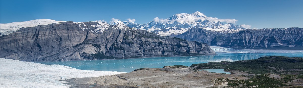
Preeminent Mountain Wilderness
Incredible. You must see Wrangell-St. Elias National Park and National Preserve to believe it. Number and scale loom large here, magnified by splendid isolation. The largest U.S. national park, it equals six Yeliowstones, with peaks upon peaks and glaciers after glaciers. Follow any braided river or stream to its source and you will find either a receding or advancing glacier. You can view representative Alaska wildlife as well as historic mining sites. Hike its mountains, float its rivers, ski its glaciers, or fly over this landscape, and you witness living geology. You sense discovery, the feeling you might be the first to see such sights.
The peaks' sheer numbers quickly quell your urge to learn their names. Just settle back and appreciate their beauty, mass, and rugged grandeur. That roads are few means many travelers will not enter the park itself, but major peaks—Blackburn, Sanford, Drum, and Wrangell—are seen from nearby highways. Or position yourself in one spot and watch sun, clouds, and storms play hide and seek with single peaks or ridges. Watch moods change by the minute here. Four major mountain ranges meet in the park, which includes nine of the 16 highest peaks in the United States. The Wrangells huddle in the northern interior. The Chugach guard the southern coast. The St. Elias Mountains rise abruptly from the Gulf of Alaska to thrust northward past the Chugach on toward the Wrangells. The eastern end of the Alaska Range—mapped as the Nutzotin and Mentasta mountains—forms part of the preserve's northern boundary.
The Wrangells are volcanic in origin, but only Mount Wrangell remains active—last reported erupting in 1900—with vents of steam near its summit. With adjoining Kluane National Park in Canada, all these ranges form North America's premier mountain wilderness. Covered year-round with snow, the highcountry stands cloaked with icefields and glaciers. Near the coast, North America's largest subpolar icefield, Bagley Icefield, spawns huge glaciers like the Tana, Miles, Hubbard, and Guyot.
The Malaspina Glacier flows out of the St. Elias Range between Icy and Yakutat bays in a mass larger than the state of Rhode Island. So much glacial silt rides it that plants and trees take hold on the glacier's extremities and grow to maturity only to topple over the edge when it melts. Flowing from glaciers are multitudes of meandering rivers and braided streams. Largest is the Copper River, forming the park's western boundary. The Copper rises in the Wrangells and empties into the Gulf of Alaska in Chugach National Forest. In the early 1900s the Kennecott Mining Co. transported copper from its mines near McCarthy by railroad along the Chitina and Copper rivers to ships at Cordova. Ore was extracted from these productive mines between 1911 and 1938 and lured many people to the area. Gold was extracted from the Nabesna area then, too. Mining still takes place on private lands in the park, and evidence of earlier mining includes ruins of the Kennecott mines, now listed on the National Register of Historic Places. In mining's heyday the Alaska native villages expanded and several new towns sprang up. Copper Center, Chitina, Gulkana, and Chistochina are near the old Athabascan settlements. The town of Yakutat is a traditional Tlingit fishing village.
While vegetation may appear sparse, especially in the interior, the park is home to a variety of wildlife. Mountain slopes have a diversity of plants, dwarf shrubs, and grasses where Dall sheep and mountain goats patrol the craggy peaks. Interior and coastal spruce forests are home to shrubs. like blueberry and prickly rose. Caribou feed on lichens and sedges on the slopes of the Wrangells. Moose browse in the sloughs and bogs of the forested lowlands, while bears roam throughout the park. Many rivers, streams, and lakes provide spawning grounds for salmon and other fish. The Copper River drainage marks major flyways for migratory birds and provides nesting sites for trumpeter swans. Coastal areas are habitat for marine mammals, including sea lions and harbor seals.
Wrangell-St. Elias, Kluane National Park in Canada, Glacier Bay National Park and Preserve, and Tatshenshini-Alsek Provincial Park in British Columbia are together a World Heritage Site—at 24 million acres one of the world's largest internationally protected areas—recognized for exceptional interest and universal value. At over 9.6 million acres, the park's designated wilderness represents nearly 10 percent of the entire National Wilderness Preservation System. Nor do superlatives end here! Explore the park and discover others for yourself.
Exploring Wrangell-St. Elias
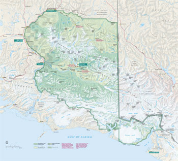 (click for larger map) |
Land Distinctions
Some areas in Wrangell-St. Elias, including McCarthy townsite and Native corporation lands, are private. Native lands may be entered by permit only. Respect the privacy of owners. Most private land lies along frequently used roads. Stick to these roads and to the trails, so you do not trespass. See maps at park headquarters or ranger stations.
In 1980 Wrangell-St. Elias was established as a national park and national preserve of 13.2 million acres. See Activities for the differences between hunting and trapping regulations for the national park and national preserve portions.
Travel Logistics
The park can be reached from Anchorage via Glenn Highway (Alaska 1). At Glennallen, Glenn Highway meets the Richardson Highway (west of the park boundary) en route to the coastal city of Valdez, which is served by the Alaska Ferry. The Tok Cutoff coming south from the Alaska Highway borders the northwestern corner.
From these highways two unpaved roads penetrate the park. The McCarthy Road extends 61 miles from Chitina to the Kennicott River, just west of McCarthy, by the old Copper River and Northwestern Railway route. This road is not regularly maintained—ask about current conditions before you start out. The trip takes about three hours and ends up at the Kennicott River, where you take a foot bridge across the river to McCarthy and the historic Kennecott Mines National Historic Landmark.
The northern park area is reached via the Nabesna Road. From Slana on the Tok Cutoff, it extends 45 miles to Nabesna, a privately owned but inactive mining camp. Check on road conditions at the ranger station at Slana.
Airplanes may be used within the boundary except in support of subsistence hunting in the park. Charters and flightseeing are available in most communities, including Anchorage, Fairbanks, Valdez, Cordova, Glennallen, Tok, and Yakutat. Cordova and Yakutat have daily commercial jet service.
Buses run between Anchorage and Valdez in summer, with stops in Glennallen. A number of companies offer river and backcountry guide services in the greater area.
Lodging, Services
Check on accommodations and make reservations in advance. Services are few, and seasons vary. Motels, restaurants, and roadhouses offer usual tourist services in major communities on highways near the park and also in the coastal communities of Yakutat, Valdez, and Cordova. Write to the park for a list of privately operated fishing camps, guide cabins, and lodges with full service that offer rustic accommodations within the park.
The Bureau of Land Management and the state of Alaska run campgrounds along the Tok Cutoff and Richardson and Edgerton highways.
Activities
This is a park for wilderness-oriented activities. Travel services and facilities are limited. You are mostly on your own and must be highly self-motivated and self-sufficient.
Some major activities besides sightseeing are backpacking, camping, hiking, fishing, hunting, mountaineering, river running, kayaking along the coast, and crosscountry skiing. No matter what you do, please read Precautions.
Backpackers and day hikers generally set out from points along the Nabesna or McCarthy roads. Trails are few; most hiking is across what may look like untraversed terrain. You may tent-camp anywhere within the park boundary except on private property. There are places for primitive camping along the McCarthy and Nabesna roads.
The park's glaciers, icefields, rivers, and steep rock walls present endless challenges for mountaineers. Mounts Sanford, Drum, Blackburn, and St. Elias attract climbing expeditions each spring.
The Copper and Chitina rivers offer excellent rafting and kayaking. The 77 miles down the Copper from Chitina to the Gulf of Alaska boast some of the park's most rugged terrain. Kayakers explore the bays, inlets, and coast in the Yakutat and Icy bay areas. March, April, and May—after the severe cold weather but with the lowlands still snow-covered—are best for cross-country skiing.
In the national park, local rural residents may carry out traditional subsistence hunting, fishing, and trapping activities. This policy recognizes rural Alaska's longstanding reliance on wildlife, fish, and plant materials.
In the national preserve, local subsistence uses are permitted, as are sport hunting, trapping, and fishing for nonresidents. Alaska licenses are required. Please do not trespass on private property.
Weather
As in most of interior Alaska, summers here are cloudy and cool, but clear, hot days are not uncommon in July, the warmest month. August and September tend to be cool and wet, with fewer mosquitoes than July. Fall can be delightfully clear, but it is a short season. Winters are cold and dark; temperatures drop to -50°F. Winter averages two feet, but days are often clear. Spring's clear skies, lengthening days, and warming temperatures break winter's hold on the land with dramatic quickness.
The weather can change by the minute and make your trip longer—plan for delays.
Precautions, Notes, Information
Help may be days away in this vast region; be extraordinarily careful. You must have proper survival gear and skills to handle mountainous terrain.
Backcountry hikers must be self-sufficient, carry enough food to cover a delay, and be prepared for wilderness. Rain gear and wool or pile clothing are essential. Ask rangers or area residents about weather conditions and if you should try to reach certain points—they know the weather and terrain from experience.
Walking over spruce muskeg with a pack can take more time than you expect. From a distance what looks like scrub lands tests endurance. You can be knee deep in water or flat on your back before you know it.
Hikers must be familiar with safe techniques for crossing streams and rivers. Many are impassable, even for experts. Others change quickly from trickling creeks to raging torrents. Be cautious. Only those with expertise in cold weather camping and with survival techniques should attempt winter camping.
Horses and dog teams may be used for backcountry travel. Snowmachines, with adequate snow cover, may be used for traditional activities. Backcountry permits are not required, but travelers are encouraged to complete a Backcountry Itinerary, available at park offices.
Source: NPS Brochure (2010)
|
Establishment
World Heritage Site — Oct. 24, 1979 |
For More Information Please Visit The  OFFICIAL NPS WEBSITE |
Documents
2014 Chisana Moose Survey Final Report (2018)
A History of the Chisana Mining District, Alaska, 1890-1990 NPS Resources Report NPS/AFARCR/CRR-96/29 (Geoffrey T. Bleakley, 1996)
A Geologic Guide to Wrangell-Saint Elias National Park and Preserve, Alaska: A Tectonic Collage of Northbound Terranes USGS Professional Paper 1616 (Gary R. Winkler, E. M. with contributions by MacKevett Jr., George Plafker, D.H. Richter, D.S. Rosenkrans and H.R. Schmoll, 2000)
A History of the Valdez Trail (Geoffrey Bleakley, April 14, 2015)
A Master Plan: Wrangell-St. Elias National Park, Alaska (December 1973)
Access and Transportation Study Work Program, Wrangell-St. Elias National Park and Preserve (Robert Peccia & Associates, June 1994)
Acoustic Bat Monitoring in Alaska National Parks 2016-2018 NPS Natural Resource Report NPS/AKRO/NRR-2020/2096 (Paul A. Burger, March 2020)
Ahtna and Wrangell-St. Elias National Park and Preserve: An Ethnographic Overview and Assessment (William E. Simeone and Odin T.W. Miller, 2024)
An Annotated Bibliography of Wrangell St. Elias National Park CPSU B-81-1 (R. Gerald Wright, 1981)
An Ecological Survey for Landcover Mapping of Wrangell-St. Elias National Park and Preserve NPS Natural Resource Technical Report NPOS/WSTR/NRTR-2008/094 (M. Torre Jorgenson, Joanna E. Roth, Patricia F. Loomis, Erik R. Pullman, Timothy C. Cater, Michael S. Duffy, Wendy A. Davis and Matthew J. Macander, March 2008)
An Ethnohistory of the Chisana River Basin (Norman Alexander Easton, 2021)
An Inventory of the Vascular Flora, Wrangell-St. Elias National Park and Preserve, Alaska NPS Natural Resource Technical Report NPS/CAKN/NRTR-2007/067 (Mary B. Cook, Carl A. Roland and Patricia A. Loomis, December 2007)
Annual Climate Monitoring Report for Denali National Park and Preserve, Wrangell-St-Elias National Park and Preserve and Yukon-Charley Rivers National Preserve (Pamela J. Sousanes, 2005)
Archaeological Resources in Wrangell-St. Elias National Park and Preserve, Alaska: An Overview and Assessment NPS Resources Report NPS/ARRCR/CRR-98/32 (February 1998)
Assessment of Coastal Water Resources and Watershed Conditions at Wrangell-St. Elias National Park and Preserve, Alaska NPS Natural Resource Technical Report NPS/NRWRD/NRTR-2006/346 (Eran Hood, Ginny Eckert, Sonia Nagorski and Carrie Talus, January 2006)
At Work in the Wrangells: A Photographic History, 1895-1966 (Katherine J. Ringsmuth, 2016)
Big Business in Alaska: The Kennecott Mines, 1898-1938 National Park Service Occasional Paper No. 1 (Melody Webb Grauman, March 1977)
Climate Change Scenario Planning for Southeast Alaska Parks: Glacier Bay, Klondike, Sitka, and Wrangell-St. Elias NPS Natural Resource Report NPS/AKSO/NRR—2014/831 (Robert Winfree, Bud Rice, John Morris, Don Callaway, Don Weeks, Jeff Mow, Nancy Fresco and Lena Krutikov, July 2014)
Community Newsletter: April 2019 • June 2020 • Spring 2021 • August 2021 • Fall 2021
Comprehensive Radar Mapping of Malaspina Glacier (Sít Tlein), Alaska—The World's Largest Piedmont Glacier—Reveals Potential for Instability (B.S. Tober, J.W. Holt, M.S. Christoffersen, M. Truffler, C.F. Larsen, D.J. Brinkerhoff and S.A. Mooneyham, extract from JGR Earth Surface, Vol. 128 Issue 3, March 2023)
Contested Ground: An Administrative History of Wrangell-St. Elias National Park and Preserve, Alaska, 1978-2001 (Geoffrey T. Bleakley, 2002)
Copper River Native Places: A report on culturally important places to Alaska Native tribes in Southcentral Alaska BLM Alaska Technical Report 56 (James Kari and Siri Tuttle, December 2005)
Cultural Landscape Inventory: Kennecott Aerial Tramways (2015)
Cultural Landscape Inventory: Kennecott Cemetery (2010)
Cultural Landscape Report: Bremner Historic District, Wrangell-St. Elias National Park and Preserve, Alaska (Paul J. White, March 2000)
Cultural Landscape Report: Kennecott Mill Town, Wrangell-St. Elias National Park and Preserve (Cathy Gilbert, Paul White and Anne Worthington, 2001)
Element concentrations and baselines for moss, lichen, spruce, and surface soils, in and near Wrangell-Saint Elias National Park and Preserve, Alaska USGS Open-File Report 93-14 (J.G. Crock, K.A. Beck, D.L. Fey, P.L. Hageman, C.S. Papp and T.R. Peacock, 1993)
Environmental geochemical studies of selected mineral deposits in Wrangell-St. Elias National Park and Preserve, Alaska USGS Professional Paper 1619 (Robert G. Eppinger, Paul H. Briggs, Danny Rosenkrans and Vanessa Ballestrazze, 2000)
For the Love of Freedom: Miners, Trappers, Hunting Guides, and Homesteaders: An Ethnographic Overview and Assessment, Wrangell-St. Elias National Park and Preserve (Karen Brewster, 2018)
Foundation Document, Wrangell-St. Elias National Park and Preserve, Alaska (Draft, August 2009)
Foundation Document Overview, Wrangell-St. Elias National Park and Preserve, Alaska (January 2017)
General Management Plan, Environmental Assessment, Land Protection Plan, Wilderness suitability Review: Wrangell-St. Elias National Park and Preserve, Alaska Draft (March 1985)
Geochemical data for environmental studies of mineral deposits at Nabesna, Kennecott, Orange Hill, Bond Creek, Bremner, and Gold Hill, Wrangell-St. Elias National Park and Preserve, Alaska USGS Open-File Report 99-342 (R.G. Eppinger, P.H. Briggs, D.S. Rosenkrans, Vanessa Ballestrazze, Jose Aldir, Z.A. Brown, J.G. Crock, W. M. d'Angelo, M.W. Doughten, D.L. Fey, P.L. Hageman, R.T. Hopkins, R.J. Knight, M.J. Malcolm, J.B. McHugh, A.L. Meier, J.M. Motooka, R. M. O'Leary, B.H. Roushey, S.J. Sultley, P.M. Theodorakos and S.A. Wilson, 1999)
Geologic Map of the Wrangell-Saint Elias National Park and Reserve, Alaska USGS Scientific Investigations Map 2877 (Donald H. Richter, Cindi C. Preller, Keith A. Labay and Nora B. Shew, 2006)
Glaciation on the North Side of the Wrangell Mountains, Alaska (Stephen R. Capps, extract from The Journal of Geology, Vol. 18 No. 1, January-February 1910)
Glacier Monitoring in Denali and Wrangell-St. Elias National Park and Preserve, 2016-2021 (Michael G. Loso, January 2022)
Glacier Monitoring in Denali and Wrangell-St. Elias National Park and Preserve, 2022-2024 (Michael G. Loso, December 2024)
Guide to the Volcanoes of the Western Wrangell Mountains, Alaska; Wrangell-St. Elias National Park and Preserve USGS Bulletin 2072 (Donald H. Richter, Danny S. Rosenkrans and Margaret J. Steigerwald, 1995)
Hazardous Waste Inventory and Sampling, Wrangell-St. Elias National Park and Preserve Standard Operating Procedure (Kit Mullen, June 1985)
High-Resolution Permafrost Modeling in Wrangell-St. Elias National Park and Preserve NPS Natural Resource Technical Report NPS/CAKN/NRTR-2014/861 (Santosh K. Panda, Sergey S. Marchenko and Vladimir E. Romanovsky, April 2014)
Historic American Engineering Record
Kennecott Mines HAER No. AK-1 (Melody Web Graumann, 1984)
Kennecott Copper Corporation, West Bunkhouse HAER No. AK-1-B (undated)
Kennecott Copper Corporation, Concentration Mill (Addendum) HAER No. AK-1-D (undated)
Kennecott Copper Corporation, Leaching Plant HAER No. AK-1-E (undated)
Kennecott Copper Corporation, Machine Shop HAER No. AK-1-G (undated)
Green Butte Copper Company HAER No. AK-9 (Sandra M. Faulkner, July 28, 1986)
Historic Structure Report: Ed. S. Orr Stage Company Superintendent's Residence (Steven M. Peterson and Douglas Beckstead, May 1991)
Hydrologic and Mass-movement Hazards near McCarthy Wrangell-St Elias National Park and Preserve, Alaska USGS Water-Resources Investigations Report 93-4078 (S.H. Jones and R.L. Glass, 1993)
Hydrologic Conditions and Hazards in the Kennicott River Basin, Wrangell-St. Elias National Park Preserve, Alaska USGS Water-Resources Investigations Report 96-4296 (R.L. Rickman and D.S. Rosenkrans, 1997)
Interpretive Concept Plan: Kennecott Mines National Historic Landmark (September 2011)
Invasive Plant Management in Wrangell-St. Elias National Park and Preserve
Invasive and Exotic Species Management for Wrangell-St. Elias National Park and Preserve: 2009 Summary Report NPS Natural Resource Data Series NPS/WRST/NRDS—2010/023 (Miranda N. Terwilliger, Lilian M. Gilmore, Katie M. Laushman, Joseph M. Donohue and Tamara E. Harper, February 2010)
Invasive Plant Management for Wrangell-St. Elias National Park & Preserve: 2010 Summary Report NPS Natural Resource Data Series NPS/WRST/NRDS—2011/128 (AnnMarie Lain, Nicole M. Liette and Miranda L. N. Terwilliger, January 2011)
Invasive Plant Management in Wrangell-St. Elias National Park & Preserve: 2011 Summary Report NPS Natural Resource Data Series NPS/WRST/NRDS—2012/230 (AnnMarie Lain, January 2012)
Invasive Plant Management in Wrangell-St. Elias National Park & Preserve: 2012 Summary Report NPS Natural Resource Data Series NPS/WRST/NRDS—2013/433 (AnnMarie Lain and Miranda L. N. Terwilliger, January 2013)
Invasive Plant Management in Wrangell-St. Elias National Park and Preserve: 2014 Summary Report NPS Natural Resource Data Series NPS/WRST/NRDS—2015/748 (Megan Weidman and Peter A. Frank, January 2015)
Invasive Plant Management in Wrangell-St. Elias National Park and Preserve: 2015 Summary Report NPS Natural Resource Report NPS/WRST/NRR—2016/1126 (Peter A. Frank, February 2016)
Invasive Plant Management in Wrangell-St. Elias National Park and Preserve: 2016 Summary Report NPS Natural Resource Report NPS/WRST/NRR—2016/1362 (Jacob DeKraai and Natalie Balkam, December 2016)
Invasive Plant Management in Wrangell-St. Elias National Park and Preserve: 2017 Summary Report NPS Natural Resource Report NPS/WRST/NRR—2018/1596 (Kate Lusby and Jason Waddington, February 2018)
Inventorying Forest Resources, Standard Operation Procedures, Wrangell-St. Elias National Park and Preserve (Kathryn Anna Beck, September 1987)
Junior Ranger Activity Book (Web Quest), Wrangell-St. Elias National Park and Preserve (Date Unknown; for reference purposes only)
Kennecott, Alaska Historic American Engineering Record Recording Project (Robert L.S. Spude and Sandra McDermott Faulkner, 1987)
Kennecott Kids: Interviews with the Children of Kennecott, Volume 1 (2005)
Kennecott Kids: Interviews with the Children of Kennecott, Volume 2 (2005)
Kennecott Kids: Oral History Project (Ann Kain, ed., June 1991)
Kennecott Mill Town Cultural Landscape Report (Cathy Gilbert, Paul White and Anne Worthington, 2001)
Kennecott Mines NHL: Graphic Layout Record Document — Rev 1 (AldrichPears Associates, September 14, 2016)
Kennecott Mines National Historic Landmark Management Strategy Draft (July 2024)
Kennicott National Monument (Proposed) (1938-1942)
Kennecott Operations and Management Plan (Draft) (2023)
Landcover Mapping Project: Wrangell-St. Elias National Park and Preserve NPS Natural Resource Technical Report NPS/WRST/NRTR-2008/095 (Kenneth Stumpf, December 2007)
Long-Range Interpretive Plan, Wrangell-St. Elias National Park and Preserve (September 2005)
Managing Historic Mining Artifacts on the Landscape (Anne Worthington, Logan Hovis, Abby Sue fisher, George Teague and Doug Beckstead, March 2002)
Malaspina Glacier (Israel C. Russell, extract from The Journal of Geology, Vol. 1 No. 3, April-May 1893)
McCarthy Road Scenic Corridor Plan (November 1997)
Mineral Resources of the Chisana-White River District U.S. Geological Survey Bulletin 622-F (Stephen R. Capps, extract from Mineral Resources of Alaska, report on progress of investigations in 1914, 1915)
Monitoring Bald Eagles in Wrangell-St. Elias National Park and Preserve, Central Alaska Network, Data Quality Standards Version 1.0 NPS Natural Resource Report NPS/CAKN/NRR-2018/1753 (Judy Putera, September 2018)
Monitoring Hazardous Fuel Reduction in Wrangell-St. Elias National Park & Preserve: Lessons Learned from the Chokosna Fuels Reduction Project NPS Natural Resource Data Series NPS/AKRO/NRDS—2013/484 (Jennifer M. McMillan and Jennifer L. Barnes, May 2013)
Monitoring Passerine Birds in the Central Alaska Network: 2015 and 2016 Summary Report for the Central Alaska Network Inventory and Monitoring Program NPS Natural Resource Report Series NPS/CAKN/NRR—2017/1478 (Laura M. Phillips, Carol L. McIntyre, Jeremy D. Mizel, Emily J. Williams and Greg M. Colligan, July 2017)
Mountain Wilderness: Historic Resource Study for Wrangell-St. Elias National Park & Preserve (William R. Hunt, 1991)
National Register of Historic Places Nomination Forms
Bremner Historic Mining District (Geoffrey T. Bleakley, February 5, 2000)
Chisana Historic District (Robert L. Spude and Michael Lappen, May 1984)
Chisana Historic Mining Landscape (Geoffrey T. Bleakley, November 15, 1997)
Historic Properties Associated with Mineral Development in Wrangell-St. Elias National Park and Preserve, Alaska, 1898-1942 (Geoffrey T. Bleakley, February 6, 2000)
Historic Properties Associated with the Valdez Trail, 1898-1943 (Geoffrey T. Bleakley, September 25, 1996)
Valdez Trail (Copper Bluff Segment) (Geoffrey T. Bleakley, August 15, 1996)
National Wetlands Inventory (NWI) Standard Mapping of the Gold Hill Mining District in Wrangell-St. Elias National Park & Preserve NPS Natural Resource Data Series NPS/WRST/NRDS—2015/750 (Andrew Robertson, John Anderson and Bonnie Maffitt, January 2015)
Natural Resource Condition Assessment, Wrangell-St. Elias National Park and Preserve NPS Natural Resource Report NPS/NRSS/WRD/NRR-2011/406 (Barry Drazkowski, Kevin Stark, Michael Komp, Greta Bernatz, Chip Brownn, Courtney Lee, Chad Richtman, Andrew Robertson and Kyle Slifka, June 2011)
Orthorectification of Historic Imagery for the Nabesna Area of Wrangell-St. Elias National Park and Preserve (GeoSpatial Services and Saint Mary's University of Minnesota, Date Unknown)
Park Newspaper (The K'ełt'aeni): 2004 • 2006 • 2007 • 2008 • 2009 • 2010 • 2011 • 2012 • 2013 • 2014 • 2015 • 2016 • 2017 • 2018 • 2019 • 2020 • 2021 • 2022 • 2023 • 2024
Preliminary Assessment Report: Kennecott Mill Site, Wrangell-St. Elias National Park and Preserve (Charles Hand, March 29, 2018)
Preliminary integrated geologic map databases for the United States: digital data for the geology of Wrangell-Saint Elias National Park and Preserve, Alaska (HTML edition) USGS Open-File Report 2005-1342 (Frederic H. Wilson, Keith A. Labay, Nora B. Shew, Cindi C. Preller, Solmaz Mohadjer and Donald H. Richter, 2005)
Protocol Development and Biological and Physical Characterization of Streams in Wrangell-St. Elias National Park and Preserve: Results of the 2006 Central Alaska Network flowing waters pilot study NPS Natural Resource Technical Report NPS/CAKN/NRTR-2009/217 (Trey Simmons, May 2009)
Report on the 1997 activity of Shrub mud volcano, Wrangell-St. Elias National Park and Preserve, southcentral Alaska USGS Open-File Report 98-128 (D.H. Richter, R.B. Symonds, D.S. Rosenkrans, R.G. McGimsey, William C. Evans and R.J. Poreda, 1998)
Quantifying bear numbers and bear-human conflicts in the Kennicott Valley of Wrangell St. Elias National Park and Preserve, Alaska Research Summary (James Wilder and R. Gerald Wright, Date Unknown)
Some Ethnographic and Historical Information on the Use of Large Land Mammals in the Copper River Basin (William E. Simeone, August 2006)
Southeast Alaska Network Freshwater Water Quality Monitoring Program
Southeast Alaska Network Freshwater Water Quality Monitoring Program: 2010 Annual Report NPS Natural Resource Technical Report NPS/SEAN/NRTR—2012/547 (Christopher J. Sergeant, William F. Johnson and Brendan J. Moynahan, February 2012)
Southeast Alaska Network Freshwater Water Quality Monitoring Program: 2011 Annual Report NPS Natural Resource Technical Report NPS/SEAN/NRTR—2012/561 (Christopher J. Sergeant, William F. Johnson and Brendan J. Moynahan, March 2012)
Southeast Alaska Network Freshwater Water Quality Monitoring Program: 2012 Annual Report NPS Natural Resource Technical Report NPS/SEAN/NRTR—2013/706 (Christopher J. Sergeant and William F. Johnson, March 2013)
Southeast Alaska Network Freshwater Water Quality Monitoring Program: 2013 Annual Report NPS Natural Resource Technical Report NPS/SEAN/NRTR—2014/840 (Christopher J. Sergeant and William F. Johnson, January 2014)
Southeast Alaska Network Freshwater Water Quality Monitoring Program: 2014 Annual Report NPS Natural Resource Report NPS/SEAN/NRR—2015/927 (Christopher J. Sergeant and William F. Johnson, February 2015)
Southeast Alaska Network Freshwater Water Quality Monitoring Program: 2015 Annual Report NPS Natural Resource Report NPS/SEAN/NRR—2016/1131 (Christopher J. Sergeant and William F. Johnson, February 2016)
Southeast Alaska Network Freshwater Water Quality Monitoring Program: 2016 Annual Report NPS Natural Resource Report NPS/SEAN/NRR—2017/1383 (Christopher J. Sergeant, William F. Johnson, February 2017)
Southeast Alaska Network Freshwater Water Quality Monitoring Program: 2017 Annual Report NPS Natural Resource Data Series NPS/SEAN/NRDS—2018/1144 (Christopher J. Sergeant, William F. Johnson, January 2018)
State of the Park Report, Wrangell-St. Elias National Park and Preserve, Alaska State of the Park Series No. 37 (2016)
Submarine Deposition of a Subaerial Landslide in Taan Fiord, Alaska (P.J. Haeussler, S.P.S. Gulick, N. McCall, M. Walton, R. Reece, C. Larsen, D.H. Shugar, M. Geertsema, J.G. Venditti and K. Labay, extract from Journal of Geophysical Research: Earth Surface, vol. 123, October 11, 2018)
Subsistence Harvests and Uses of Wild Resources in Kenny Lake/Willow Creek, Gakona, McCarthy, and Chitina, Alaska, 2012 (Robbin La Vine and Garrett Zimpelman, eds., December 2014)
Surficial Geology and Proglacial Lake Change at Sít' Tlein (Malaspina Glacier), Wrangell-St. Elias National Park and Preserve, Alaska NPS Natural Resource Repport NPS/WRST/NRR-2024/2620 (Anna C. Thompson, Michael G. Loso, Sydney A. Mooneyham, Brandon S. Tober, Christopher F. Larsen and John W. HOlt, January 2024)
Tanada Lake Trail Integrated Terrain Unit Mapping and Permafrost Surveys, Wrangell-St. Elias National Park and Preserve, Alaska, 2012 (Aaron Wells, January 2013)
Terminal Pleistocene human occupation of the upper Copper River basin, southern Alaska: Results of test excavations at Nataeł Na' (John T. White, Auréade Henry, Stephen Kuehn, Michael G. Loso and Jeffrey T. Rasic, extract from Quaternary International, vol. 640, September 18, 2022)
That's The Way We Live: Subsistence in the Wrangell-St. Elias National Park and Preserve Cooperative Park Studies Unit Occasional Paper No. 34 (Holly Reckord, 1983)
The 2015 landslide and tsunami in Taan Fiord, Alaska (Bretwood Higman, Dan H. Shugar, Colin P. Stark, Göran Ekström, Michele N. Koppes, Patrick Lynett, Anja Dufresne, Peter J. Haeussler, Marten Geertsema, Sean Gulick, Andrew Mattox, Jeremy G. Venditti, Maureen A. L. Walton, Naoma McCall, Erin Mckittrick, Breanyn MacInnes, Eric L. Bilderback, Hui Tang, Michael J. Willis, Bruce Richmond, Robert S. Reece, Chris Larsen, Bjorn Olson, James Capra, Aykut Ayca, Colin Bloom, Haley Williams, Doug Bonno, Robert Weiss, Adam Keen, Vassilios Skanavis and Michael Loso, extract from Scientific Reports, vol. 8 art. 12993, September 6, 2018)
The Chisana-Gold Hill Landscape: A Cultural Landscape Report (1998)
The Machine Shop at Kennecott: A Collection Plan (Mary Ann Sweeney, June 1, 2000)
The Malaspina Glacier Region of Alaska (Lawrence Martin, extract from The Journal of Geology, Vol. 17 No. 7, October-November 1909)
The Mineral Resources of the Mount Wrangell District, Alaska U.S. Geological Survey Professional Paper No. 15 (Walter C. Mendenhall and Frank C. Schrader, 1903)
Trends in abundance of common passerine species in Wrangell-St. Elias National Park and Preserve, 1997-2019 NPS Natural Resource Report NPS/CAKN/NRR-2021/2282 (Jeremy Mizel and Jared Hughey, July 2021)
Tunnel Vision: The Life and Times of a Copper Prospector in the Nizina Mining District (Katherine Ringsmuth, 2012)
Upper Tanana Ethnographic Overview and Assessment, Wrangell St. Elias National Park and Preserve (Terry L. Haynes and William E. Simeone, July 2007)
Visual Communication Guidelines: Kennecott Mines National Historic Landmark, Wrangell-St. Elias National Park and Preserve, Alaska (September 14, 2016)
Water Resources Scoping Report, Wrangell-St. Elias National Park and Preserve, Alaska NPS Natural Resource Technical Report NPS/NRWRD/NRTR-2003/315 (Don P. Weeks, August 2003)
Wolf Monitoring Protocol for Denali National Park and Preserve, Yukon-Charley Rivers National Preserve and Wrangell-St. Elias National Park and Preserve NPS Natural Resource NPS/CAKN/NRR-2009/168 (Thomas J. Meier and John W. Burch, December 2004 revised August 2009)
Yakutat Tlingit and Wrangell-St. Elias National Park and Preserve: An Ethnographic Overview and Assessment (Douglas Deur, Thomas Thornton, Rachel Lahoff and Jamie Hebert, 2015)
Yakutat Tlingit and Wrangell-St. Elias National Park and Preserve: An Ethnographic Overview and Assessment — Appendix A: Annotated Bibliography (Rachel Lahoff, Thomas Thornton and Douglas Deur, August 2015)
wrst/index.htm
Last Updated: 08-Jan-2025