
|
Geological Survey Professional Paper 669
The Colorado River Region and John Wesley Powell |
GEOLOGIC HISTORY OF THE COLORADO RIVER
By
Charles B. Hunt
GEOLOGICAL SURVEY PROFESSIONAL PAPER 669—C
Thirty million years of changes in the rivers and canyons that Powell was first to explore.
TABLE OF CONTENTS
(A) John Wesley Powell: Pioneer statesman of Federal science, by Mary C. Rabbitt
(B) Stratified rocks of the Grand Canyon, by Edwin D. McKee
(C) Geologic history of the Colorado River, by Charles B. Hunt
Abstract
Introduction
The problem
Setting
Previous work
Acknowledgments
Descriptive geology
Upper Colorado River basin—above the Green River
Green and Yampa Rivers
Canyons south of the Uinta Basin
Significance of unconformities
San Juan and Little Colorado Rivers Grand Canyon—grand problem
Grand Canyon to the Gulf of California
Some conclusions
Bibliography
(D) The rapids and the pools—Grand Canyon, by Luna B. Leopold
|
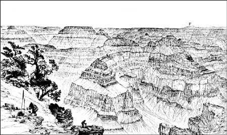
| Grand Canyon, as sketched by W. H. Holmes of the Powell Survey and published in Dutton's monograph (1882) on Grand Canyon. View is about southeast along the axis of the Kaibab upwarp. In the distant skyline, right, is San Francisco Mountain (F) and other volcanoes in the volcanic field south of Grand Canyon. The plateau surface is Permian limestone (Kaibab Limestone); the canyon walls seen in this view are mostly Permian, Pennsylvanian, and Mississippian formations. Altitude of the rim here is about 8,200 feet; bottom of the canyon (out of sight) is below 3,000 feet. San Francisco Mountain, about 70 miles away, is above 12,600 feet. |
ILLUSTRATIONS
FIGURE
28. Topographic map of the Colorado River basin
29. Physiographic diagram of the Colorado River basin
30. Map showing annual precipitation in the Colorado River basin and average annual discharge of the principal rivers
31. Geologic map of the Colorado River basin
32. Physiographic map of the Colorado River above Grand Junction
33. Map showing ancestral drainage into the Uinta basin and present drainage
34-37. Photographs:
34. Middle Park
35. Gore Canyon
36. Colorado River valley in structural basin of the State Bridge syncline
37. East flank of the White River Plateau
38. Geologic map of the Colorado River basin the Rocky Mountains
39. Photograph of glacial valley at head of Roaring Fork
40. Profiles of the Colorado River
41. Topographic map of Gore Canyon and the wind gap south of it
42. Geologic map and section of the Gunnison River valley
43. Structure contour map along the Gunnison River valley drawn at base of Tertiary lavas
44. Photograph of Black Canyon of the Gunnison River
45. Physiographic diagram showing drainage changes on the north side of the Black Canyon of the Gunnison River
46. Physiographic diagram showing Taylor Park and Taylor River Canyon
47. Topographic map of the Grand Junction area
48. Photograph of Unaweep Canyon
49. Geologic map of Unaweep Canyon area
50. Diagrams showing drainage changes in the Grand Junction area
51. Profiles across the valleys of the Gunnison and Colorado Rivers above Grand Junction
52. Photograph of Colorado River valley above Grand Junction
53. Map showing faulted anticlines and the courses of the Dolores and Colorado Rivers
54. Physiographic diagram of the Dolores River drainage basin
55. Photograph of the Colorado River at The Loop
56. Cross-valley profile of the Green and Colorado River Canyons
57. Photograph of Green River valley at Gates of Lodore
58. Geologic map of the Yampa River valley
59. Photograph of the Yampa River emerging from Cross Mountain
60. Geologic cross section of the Uinta basin
61. Map of the eastern part of the Uinta Mountains showing distribution of Browns Park Formation
62. Structure contour map on the Kaibab Limestone in the Colorado Plateau
63. Diagram showing suggested drainage system into the Henry Mountains structural basin
64. Topographic map showing meander patterns of the Colorado, Green, and Dirty Devil Rivers
65. Photograph of Cataract Canyon
66. Topographic map showing cutoff meander at the Rincon in Glen Canyon
67. Photograph of Glen Canyon
68. Geologic map of the Four Corners area
69. Map showing probable drainage lines in Arizona during late Miocene and Pliocene time
70. Geologic section of the Defiance upwarp
71. Topographic map of Chaco River where it loins the San Juan at The Hogback
72. Geologic section of the Mogollon Rim
73. Structure contour map of the base of the Bidahochi Formation, and probable course of ancestral Little Colorado River
74. Topographic map of Grand Canyon region
75. Geologic map and diagrammatic section of the Grand Canyon region showing the several plateaus
76. Photograph of the Grand Wash Cliffs at the foot of Grand Canyon
77. Cross sections of the dry canyon at Peach Springs and of Grand Canyon along the Hurricane fault zone
78. Map showing inferred drainage pattern in Grand Canyon area when the Bidahochi Formation was deposited
79. Physiographic diagram of basins and ranges west of Grand Canyon and possible ancestral course of the Colorado River
80. Cross section of the Big Sandy and Chino River valleys
81. Aerial photograph of the canyon of the Colorado River in the Black Mountains
82. Topographic map and cross sections of the Colorado River valley between Hoover Dam and Davis Dam
83. Photograph of fanglomerate bluffs and flood plain near Parker Ariz
84. Map showing contrasts in drainage systems east and west of the Colorado River in Arizona and Colorado
85. Map showing distribution of earthquake epicenters in southwestern United States
TABLES
TABLE
1. Principal interpretations of process and age for various parts of the Colorado River system
2. Geologic history of the Colorado River
| <<< Previous | <<< Contents >>> | Next >>> |
pp/669/secc.htm
Last Updated: 22-Jun-2006